GNSS Signal Quality in Forest Stands for Off-Road Vehicle Navigation
Abstract
1. Introduction
2. Material and Methods
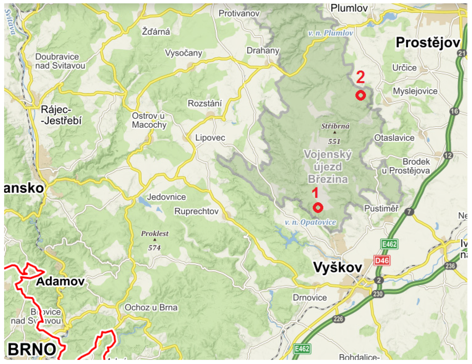
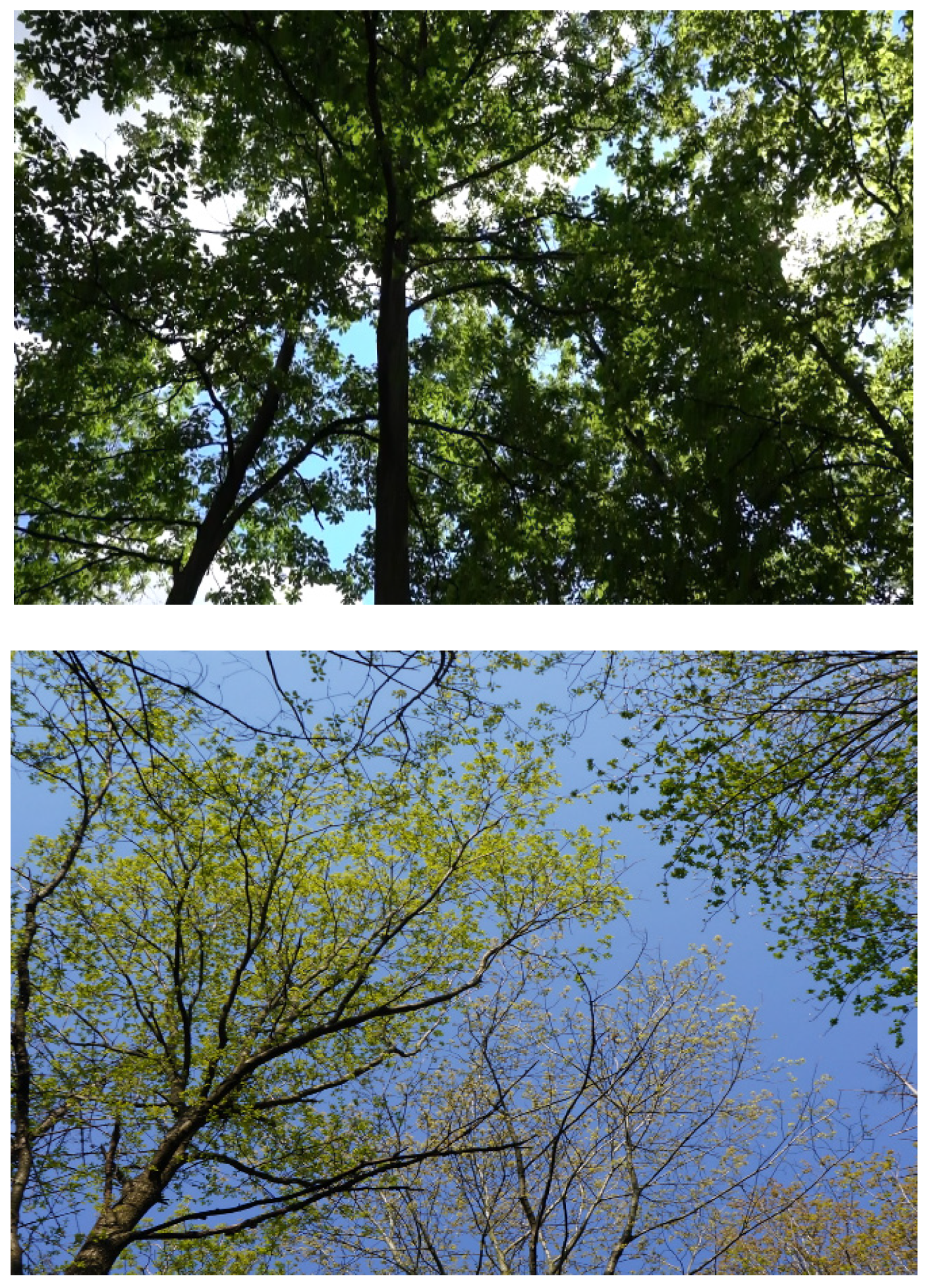
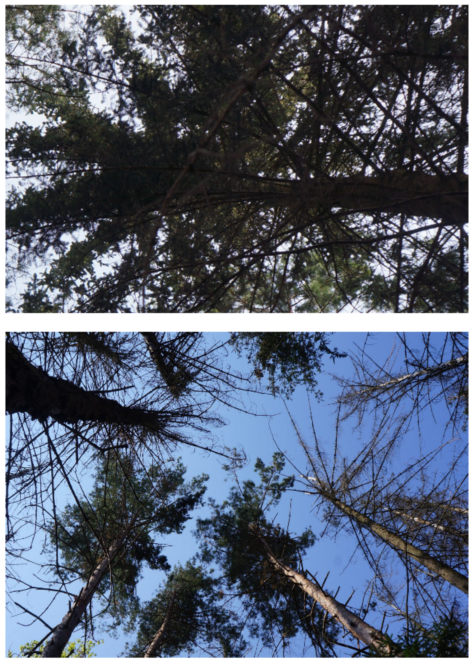
2.1. Characteristics of Localities No. 1 and No. 2
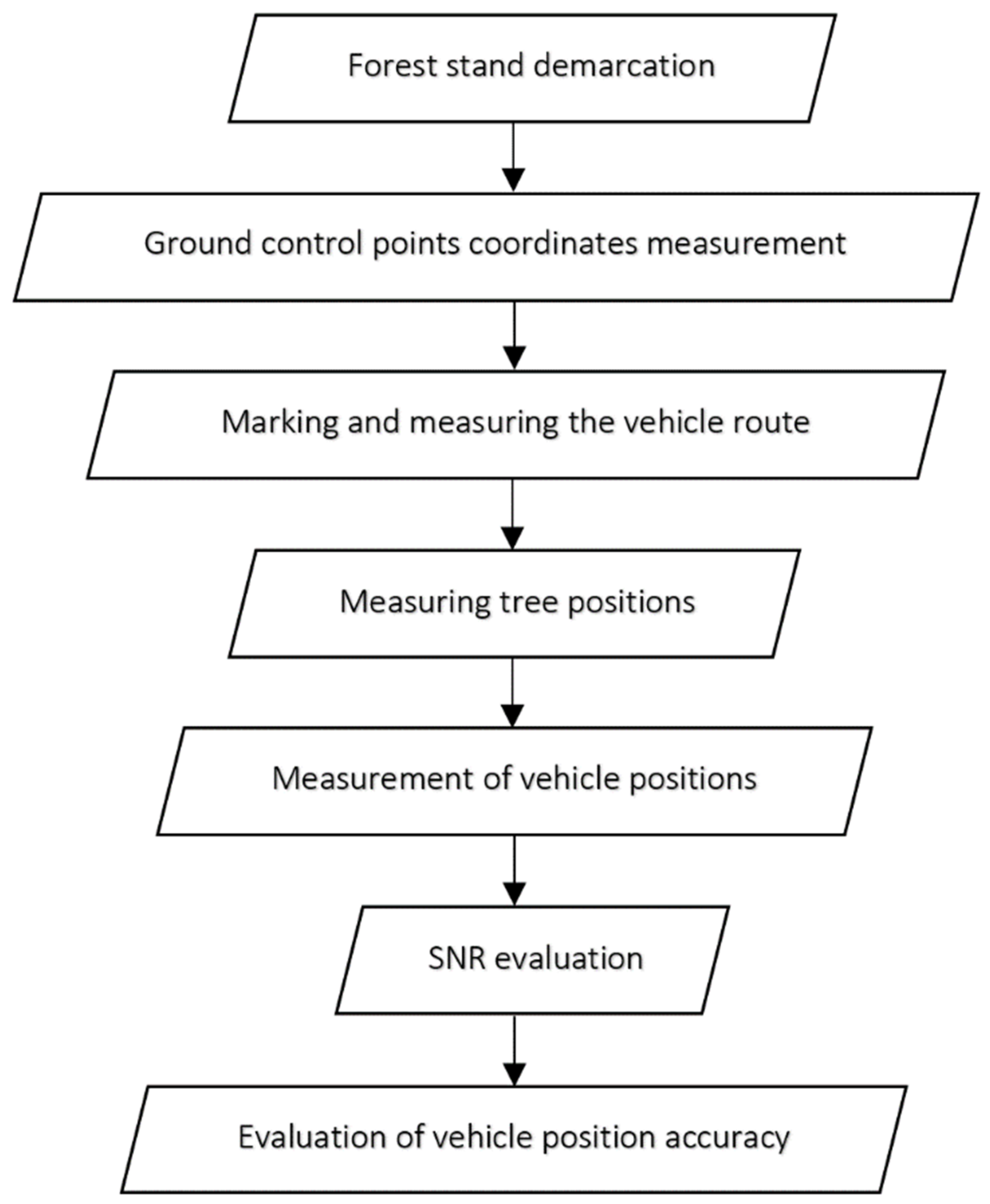
2.2. Measurement Methodology
- Demarcation of forest stand for testing with a focus on finding a relatively homogeneous part of the forest in which there were representative tree types of stand;
- Surveying the coordinates of the reference ground control points around the forest and in the middle of the forest (places not covered by vegetation) using the GNSS, Trimble Geo XR with Zephyr model 2 Geo XR antenna, the Trimble Geo 7X cm version with antenna, Tornado pro 7X devices with 2–3 cm estimated position error, and using the real time VRS (virtual reference station) method. Selected parameters of receiver Geo 7X were: firmware GNSS: 4.50.8.; software GNSS: Terra Sync version 5.86.; number of channels: 142 (max. 220); GNSS types: GPS L1/L2 (L1E, L2C), GLONASS G1/G2, Galileo E1, and BeiDou B1; SBAS types: WAAS and EGNOS;
- For field measurements, the GNSS receiver was set as: measurement mode: 1; external GNSS: 2; SBAS: 3; autonomous mode; logging interval: 1 s; elevation mask: 5°; PDOP mask: 99; signal to noise ratio (SNR): 12; and height of the external antenna location: 1 m;
- The number of reference ground control points depended on the density of forest stands;
- Measuring tree positions using tachymetry. The measurement was performed from reference ground control points, from which there was good visibility to the surrounding trees. First, the distance was measured on a pole with a surveying prism touching the tree from the side. Then the pole was moved in front of the center of the tree and the azimuth was measured. This avoided measuring eccentricities, i.e., diameter at breast high (DBH) measurement. During the measurement, the surveying prism was placed at a height of 1.3 m above the ground surface;
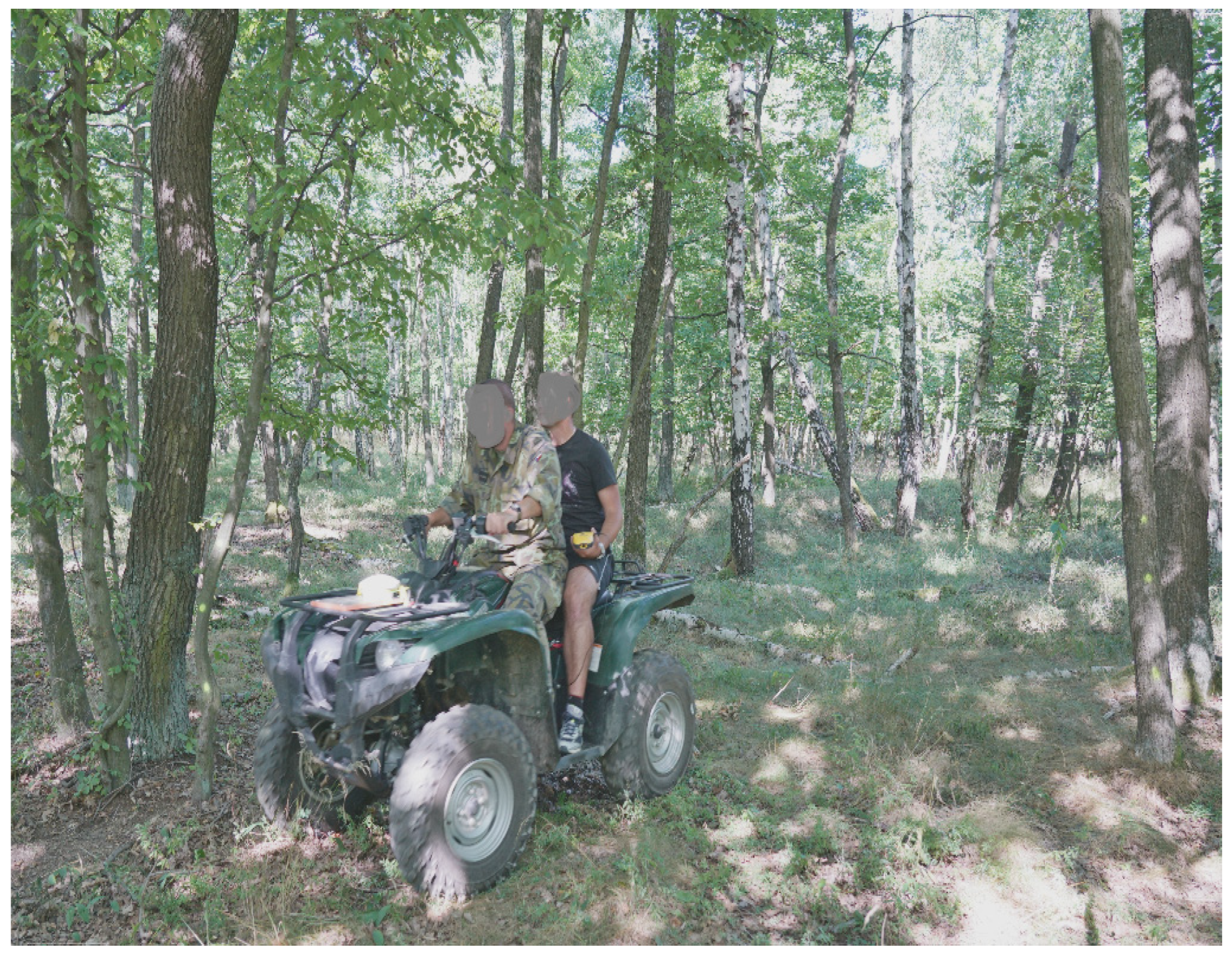
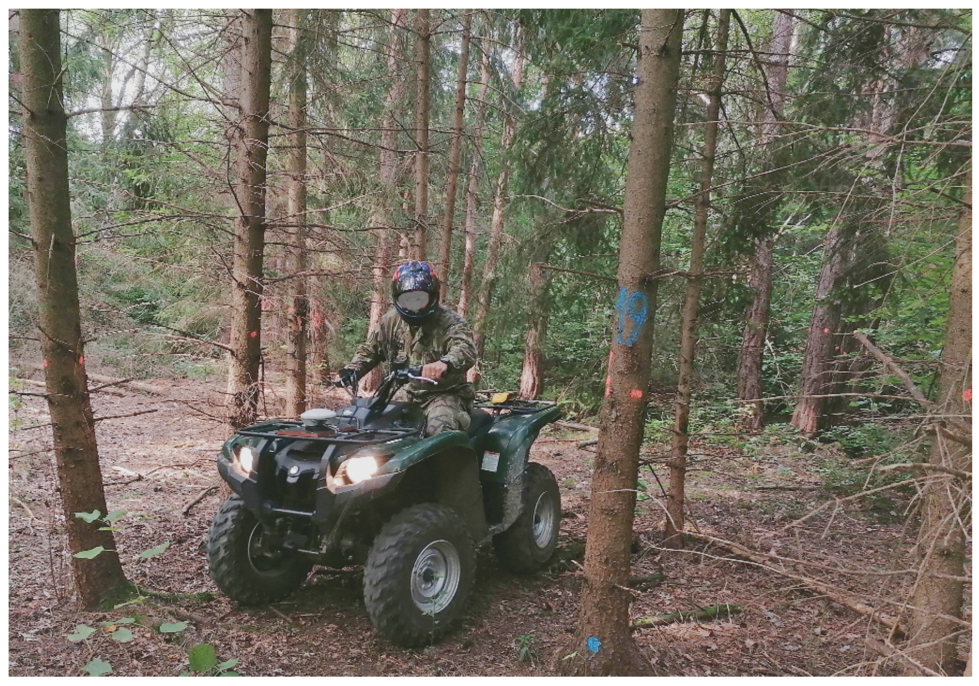
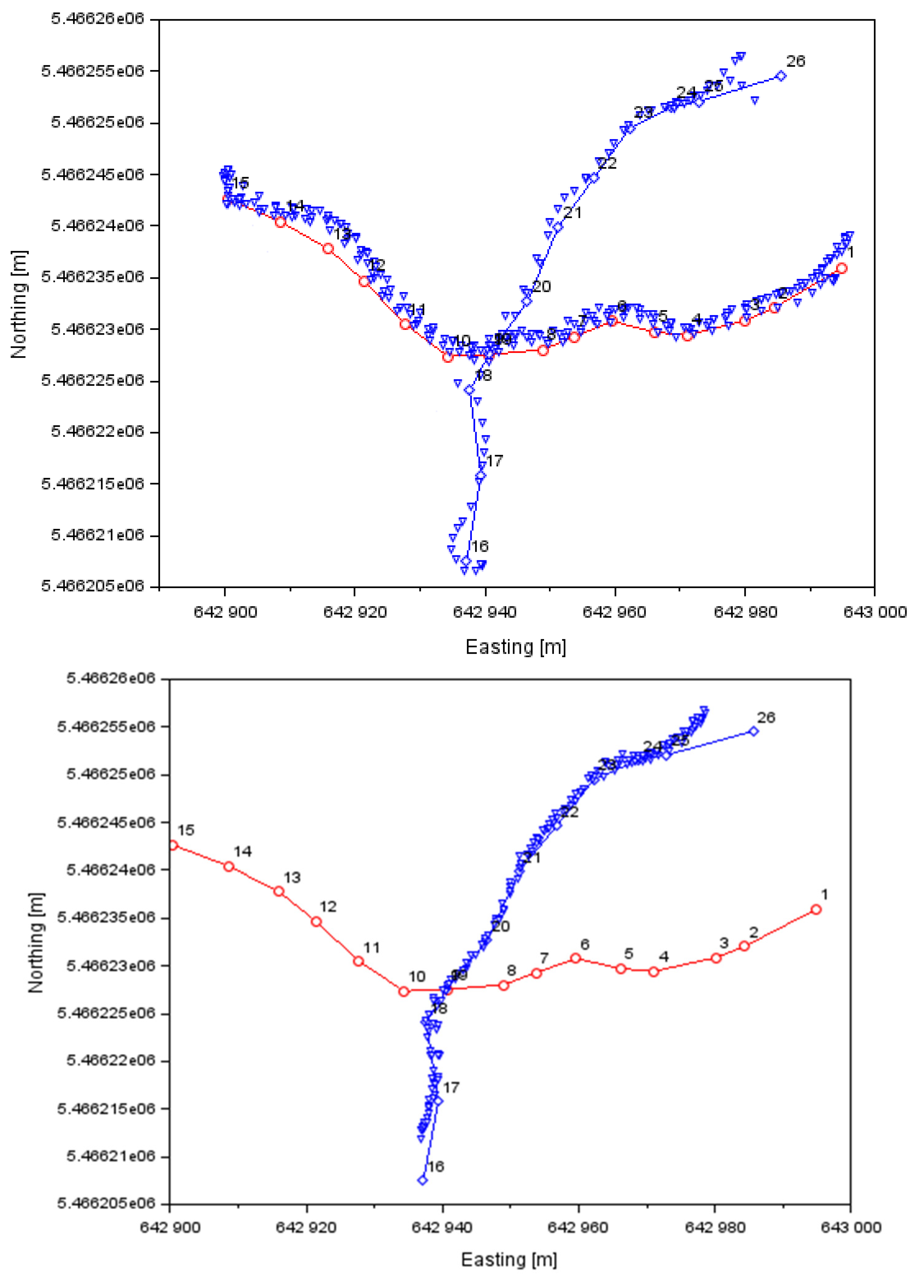
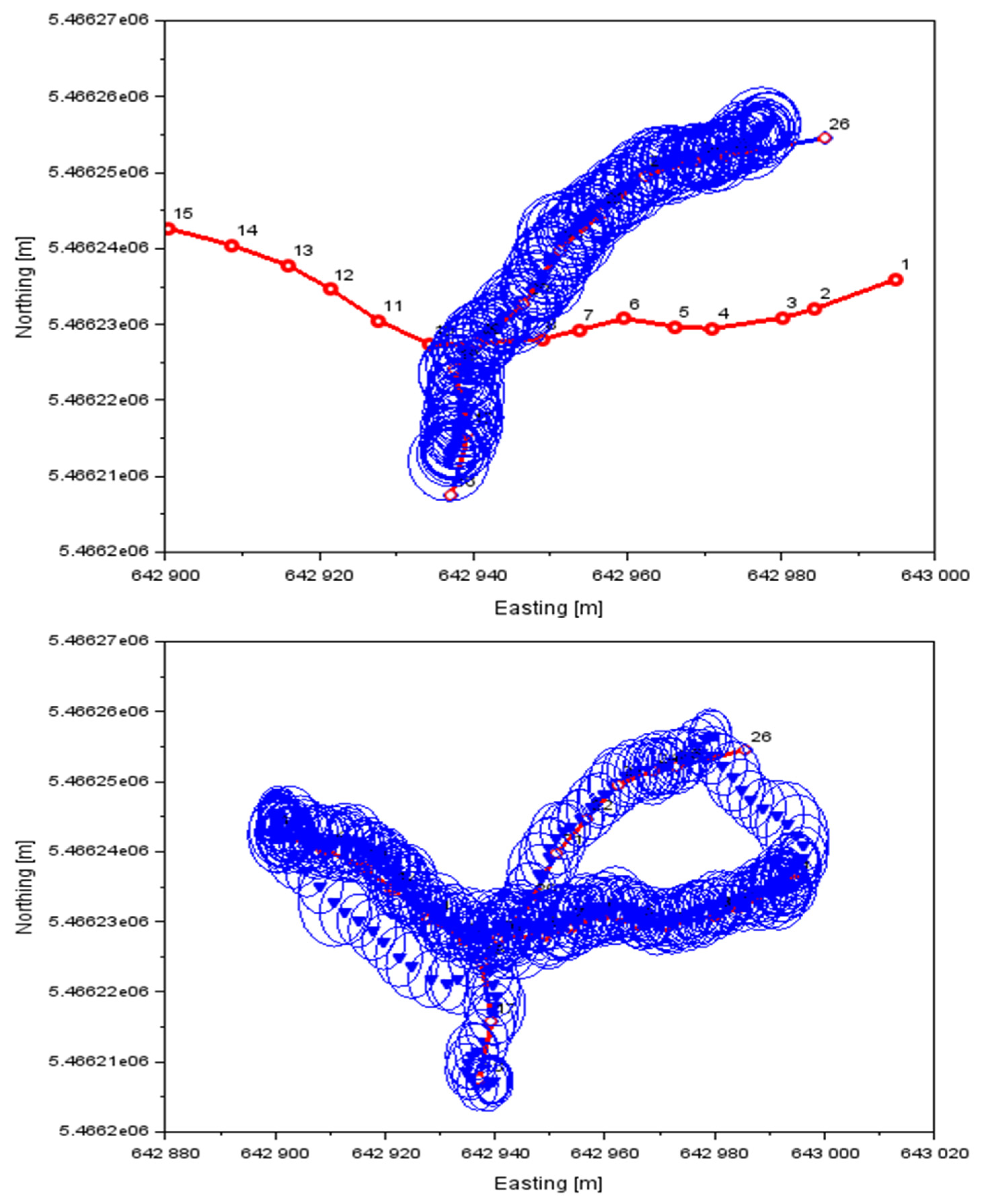
- Measurement of vehicle positions while driving between pre-marked trees. The GNSS Tornado pro 7X antenna of the Geo 7X receiver and the device itself were attached to the front of the vehicle body at a height of 1.0 m. The vehicle was moving between reference trees for which position coordinates had previously been measured on a route previously targeted by the tachymetric method. Before the actual testing, the route along which the vehicle was moving was also marked with a spray. This route was also measured using tachymetry in order to determine the deviations between the reference route and the routes located using the GNSS method. Deviations of vehicle movement from the reference marked path depended on the terrain configuration and vegetation density. The speed of the moving vehicle was 3–5 km·h−1, the distances between the trees were 3 m to 5 m, the height of the trees was approximately 15 m. For most of the vehicle’s path, the sky was obscured by tree branches. The receiving of satellite signals was characterized by frequent short-term outages;
- Evaluation of signal-to-noise ratio (SNR) as a function of the influence of vegetation density on the quality of the received GNSS signal;
- Evaluation of the position accuracy of a moving vehicle, determined by a GNNS receiver and compared with the coordinates of a pre-targeted vehicle route.
3. Results
3.1. Tachymetric Determination of Tree Positions
3.2. GNSS Signal Quality Evaluation
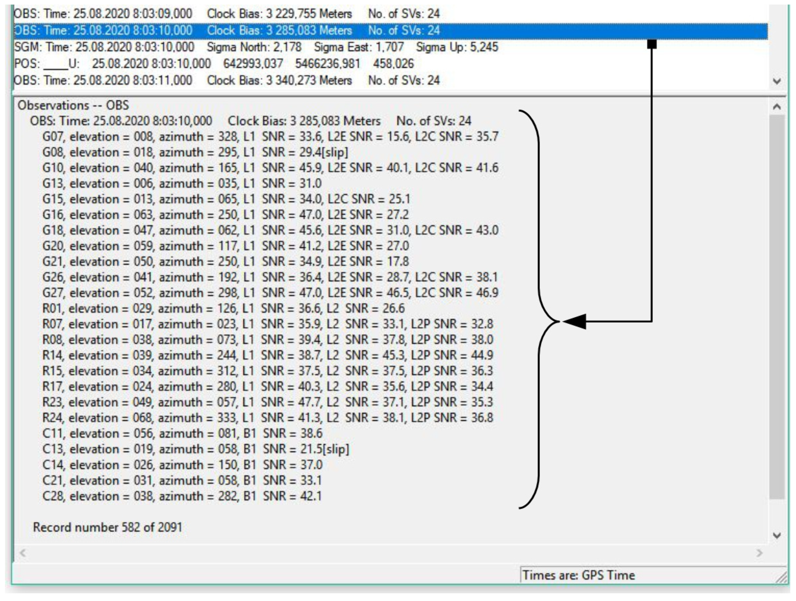
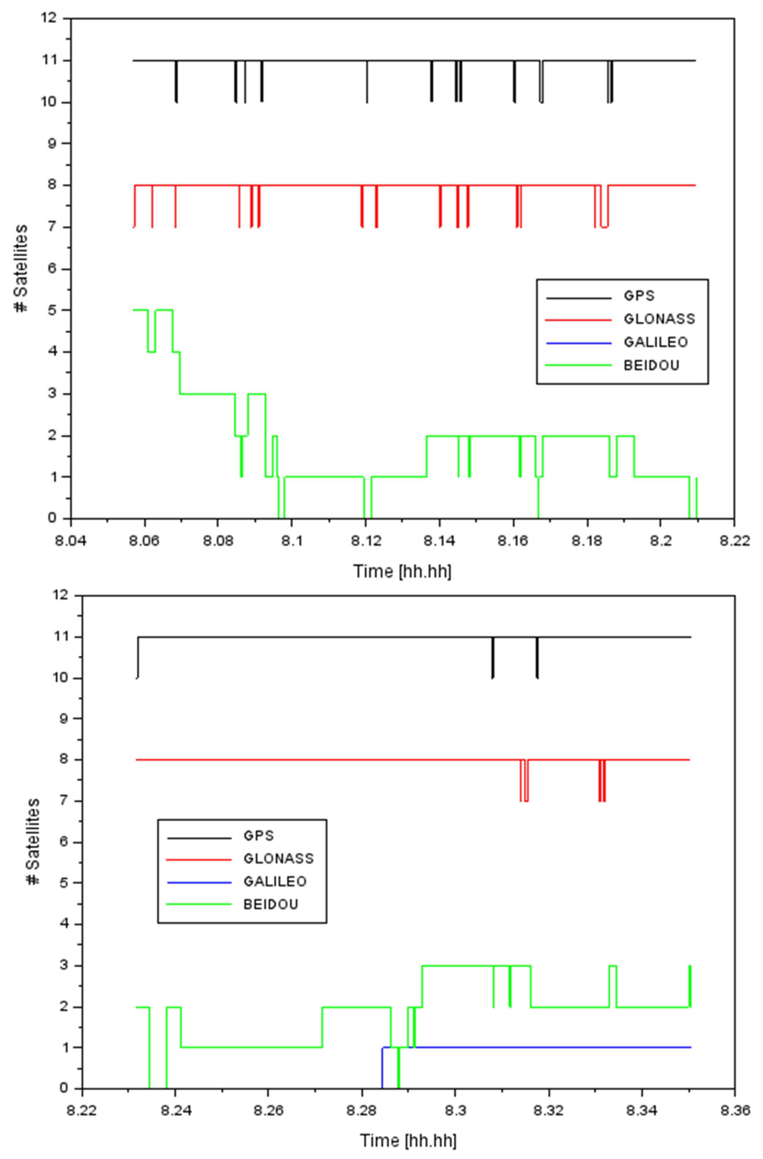
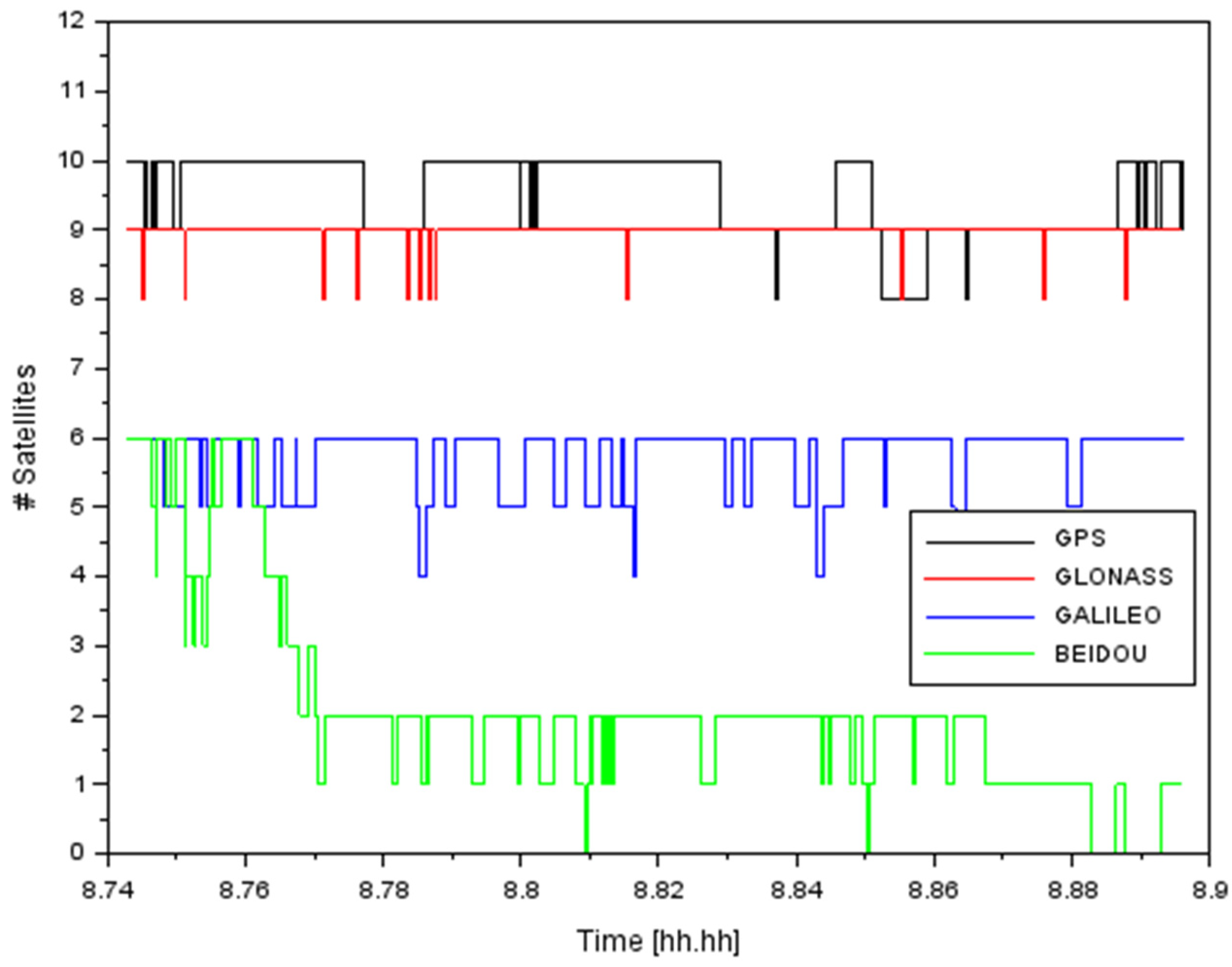
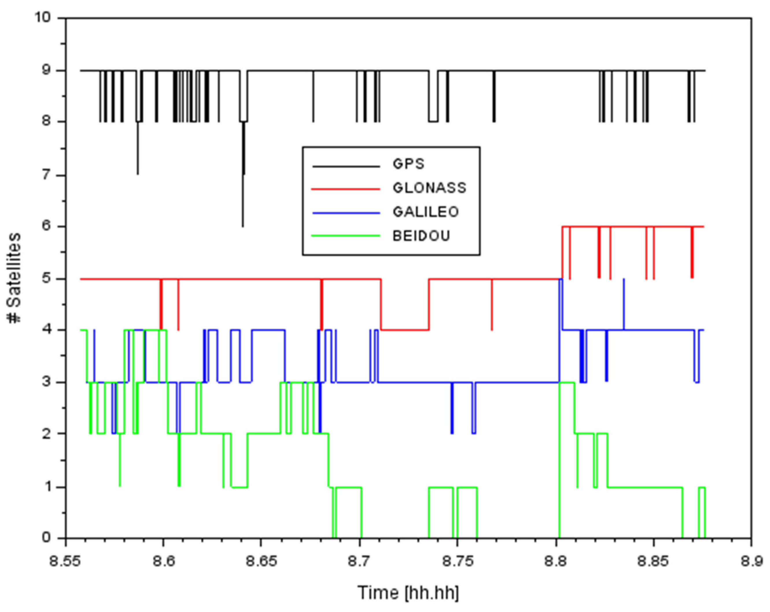
- Number of satellites of individual GNSS types;
- GNSS receiver antenna coordinates in 1 s intervals;
- Accuracy estimates (standard deviations) of coordinates in the direction “north-south”—sigma north “east-west”—sigma east , and height—sigma up;
- Average values of PDOP and SNR of satellite signals during measurement;
- GPS connection time to all records.
3.3. Accuracy of Vehicle Positioning Using the GNSS Method
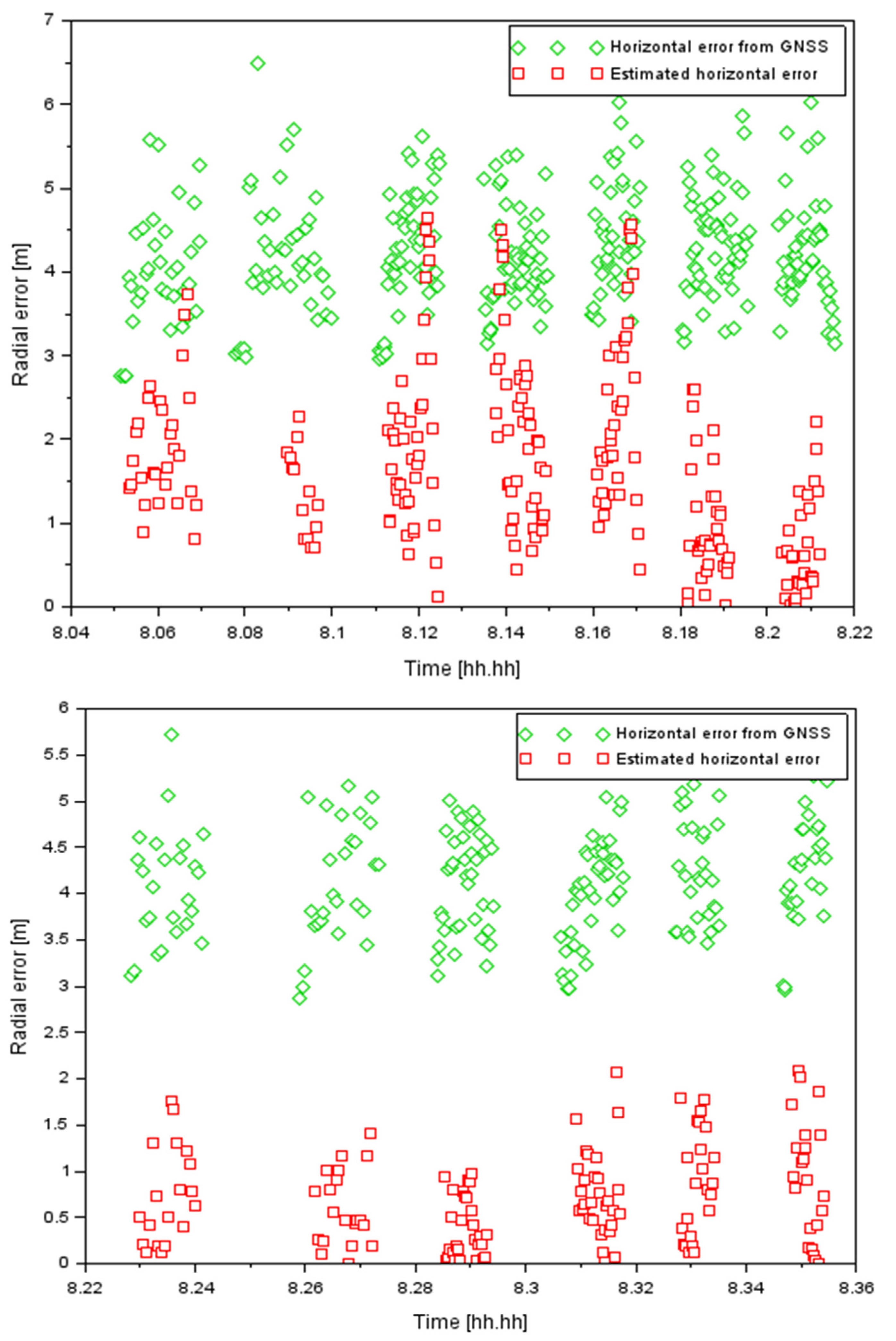
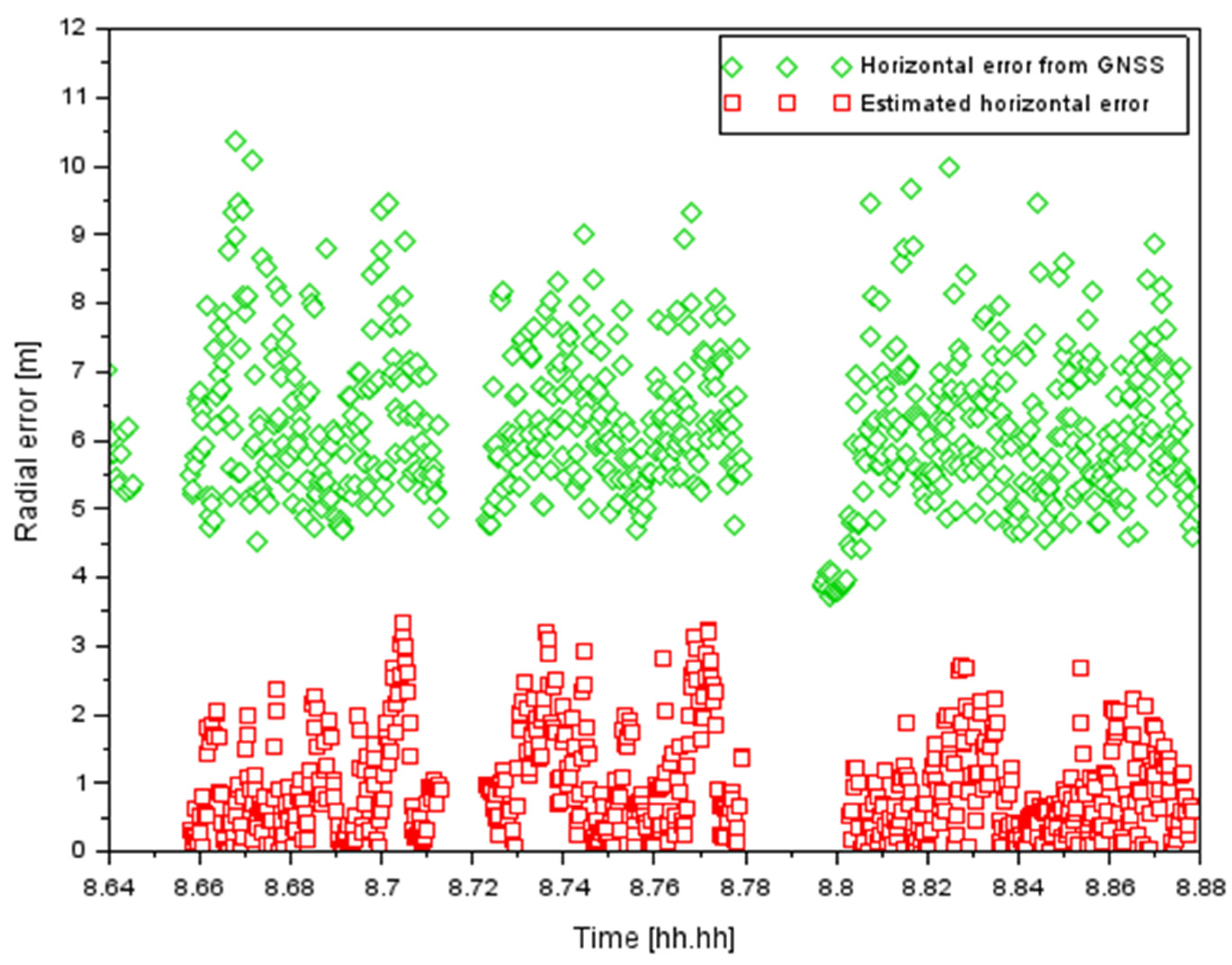
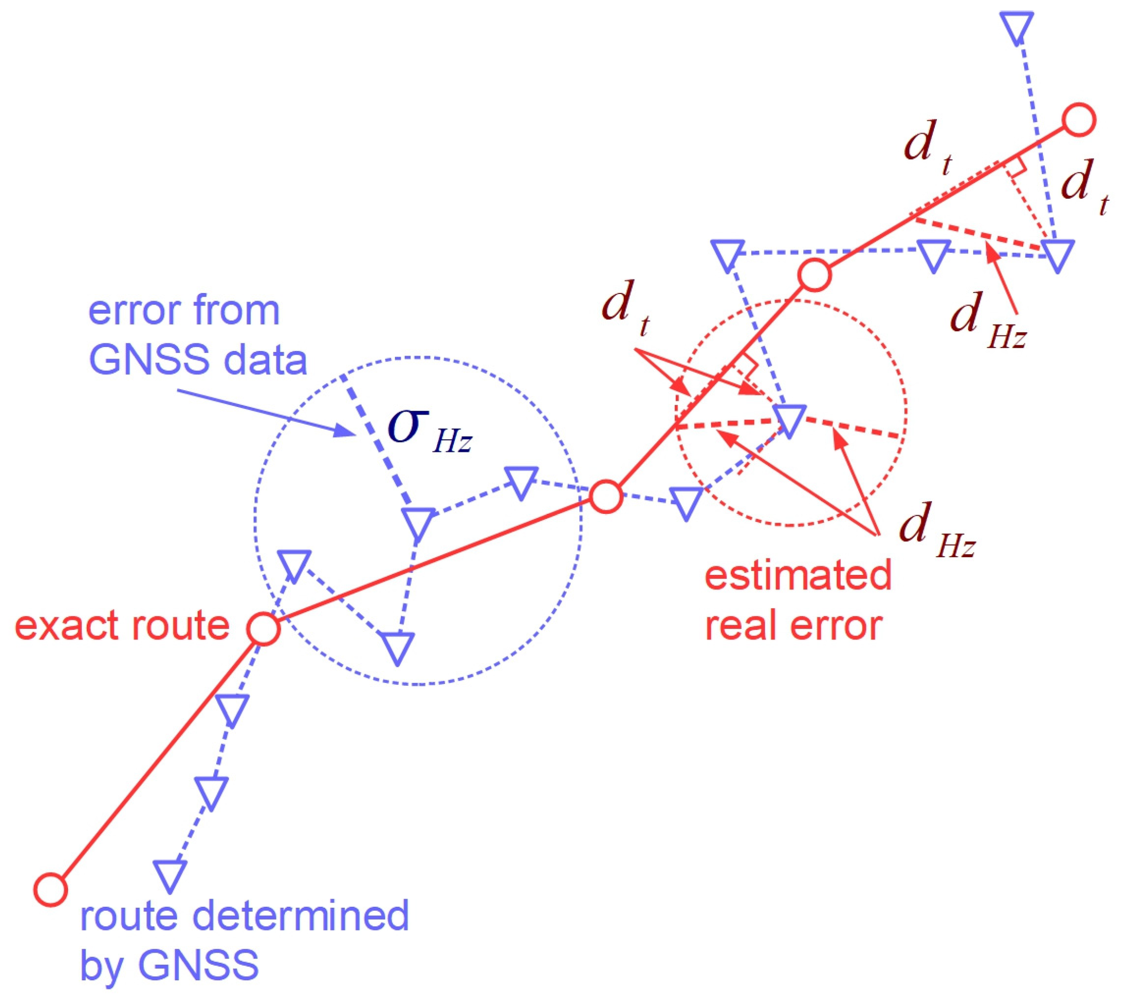
- Square mean of radial (horizontal) deviations:
- 2.
- Percentiles of values and . Two percentile levels were chosen: 63%, which theoretically corresponded to the value , and 95%, theoretically corresponding to the value .
4. Discussion
5. Conclusions
Author Contributions
Funding
Institutional Review Board Statement
Informed Consent Statement
Data Availability Statement
Acknowledgments
Conflicts of Interest
References
- Rada, J.; Rybansky, M.; Dohnal, F. The Impact of the Accuracy of Terrain Surface Data on the Navigation of Off-Road Vehicles. ISPRS Int. J. Geo-Inf. 2021, 10, 106. [Google Scholar] [CrossRef]
- Rada, J.; Rybansky, M.; Dohnal, F. Influence of Quality of Remote Sensing Data on Vegetation Passability by Terrain Vehicles. ISPRS Int. J. Geo-Inf. 2020, 9, 684. [Google Scholar] [CrossRef]
- Rybansky, M.; Hofmann, A.; Hubacek, M.; Kovarik, V.; Talhofer, V. Modelling of cross-country transport in raster format. Environ. Earth Sci. 2015, 74, 7049–7058. [Google Scholar] [CrossRef]
- Rybansky, M. Determination the ability of military vehicles to override vegetation. J. Terramechan. 2020, 91, 129–138. [Google Scholar] [CrossRef]
- Pokonieczny, K.; Rybansky, M. Method of Developing the Maps of Passability for Unmanned Ground Vehicles. In Proceedings of the IOP Conference Series: Earth and Environmental Science, 9th IGRSM International Conference and Exhibition on Geospatial & Remote Sensing (IGRSM 2018), Kuala Lumpur, Malaysia, 24–25 April 2018; pp. 1–9. [Google Scholar]
- Stodola, P.; Drozd, J.; Nohel, J.; Michenka, K. Model of Observation Posts Deployment in Tactical Decision Support System. In Artificial Intelligence and Lecture Notes in Bioinformatics; Lecture Notes in Computer Science (Including Subseries Lecture Notes); Springer: Berlin/Heidelberg, Germany, 2020; Volume 11995 LNCS, pp. 231–243. [Google Scholar] [CrossRef]
- Nohel, J.; Stodola, P.; Flasar, Z. Combat UGV Support of Company Task Force Operations. In Artificial Intelligence and Lecture Notes in Bioinformatics; Lecture Notes in Computer Science (Including Subseries Lecture Notes); Mazal, J., Fagiolini, A., Vasik, P., Turi, M., Eds.; Springer: Cham, Switzerland; Science and Business Media Deutschland GmbH: Baden-Wuerttemberg, Germany, 2021; Volume 12619 LNCS, pp. 29–42. ISBN 978-3-030-70739-2. [Google Scholar] [CrossRef]
- Dawid, W.; Pokonieczny, K. Analysis of the Possibilities of Using Different Resolution Digital Elevation Models in the Study of Microrelief on the Example of Terrain Passability. Remote Sens. 2020, 12, 4146. [Google Scholar] [CrossRef]
- Dawid, W.; Pokonieczny, K. Methodology of Using Terrain Passability Maps for Planning the Movement of Troops and Navigation of Unmanned Ground Vehicles. Sensors 2021, 21, 4682. [Google Scholar] [CrossRef]
- Drozd, J.; Stodola, P.; Křišťálová, D.; Kozůbek, J. Experiments with the UAS Reconnaissance Model in the Real Environment. In Modelling and Simulation for Autonomous Systems; Springer International Publishing: Cham, Switzerland, 2018; pp. 340–349. ISBN 978 3 319 76071 1. [Google Scholar]
- Heštera, H.; Pahernik, M. Physical-geographic factors of terrain trafficability of military vehicles according to Western World methodologies. Hrvat. Geogr. Glas. Geogr. Bull. 2018, 80, 5–31. [Google Scholar] [CrossRef]
- Hoskova-Mayerova, S. Geospatial Data Reliability, Their Use in Crisis Situations. In Proceedings of the 21st International Scientific Conference on The Knowledge-Based Organization (KBO), Sibiu, Romania, 15–17 June 2023; pp. 694–698. [Google Scholar]
- Hoskova-Mayerova, S.; Talhofer, V.; Otrisal, P.; Rybansky, M. Influence of Weights of Geographical Factors on the Results of Multicriteria Analysis in Solving Spatial Analyses. ISPRS Int. J. Geo-Inf. 2020, 9, 489. [Google Scholar] [CrossRef]
- Raši, R. State of Europe’s Forests 2020; Ministerial Conference on the Protection of Forests in Europe—FOREST EUROPE: Zvolen, Slovakia, 2020; Available online: https://foresteurope.org/wp-content/uploads/2016/08/SoEF_2020.pdf (accessed on 15 October 2022).
- European Union. Forestry in the EU and the World; Publications Office of the European Union: Luxembourg, 2011.
- Hyyppä, J.; Inkinen, M. Detecting and estimating attributes for single trees using laser scanner. Photogramm. J. Finl. 1999, 16, 27–42. [Google Scholar]
- Persson, A.; Holmgren, J.; Söderman, U. Detecting and measuring individual trees using an airborne laser scanner. Photogramm. Eng. Remote Sens. 2002, 68, 925–932. [Google Scholar]
- Peuhkurinen, J.; Maltamo, M.; Malinen, J.; Pitkänen, J.; Packalén, P. Preharvest measurement of marked stands using airborne laser scanning. For. Sci. 2007, 53, 653–661. [Google Scholar]
- Zheng, J.; Wang, Y.; Nihan, N.L. Quantitative Evaluation of GPS Performance under Forest Conopies; Department of Civil and Environmental Engineering, University of Washington: Seattle, WA, USA, 2002. [Google Scholar]
- Piedallu, C.; Gégout, J.C. Effect of forest environment and survey protocol on GPS accuracy. Photogramm. Eng. Remote Sens. 2005, 71, 1071–1078. [Google Scholar] [CrossRef]
- Valbuena, R.; Mauro, F.; Rodriguez-Solano, R.; Manzanera, J.A. Accuracy and precision of GPS receivers under forest canopies in a mountainous environment. Span. J. Agric. Res. 2010, 8, 1047–1057. [Google Scholar] [CrossRef]
- Galán, C.O.; Rodríguez-Pérez, J.R.; Torres, J.M.; García Nieto, P.J. Analysis of the influence of forest environments on the accuracy of GPS measurements by using genetic algorithms. Math. Comput. Model. 2011, 54, 1829–1834. [Google Scholar] [CrossRef]
- Bastos, A.S.; Hasegawa, H. Behavior of GPS signal interruption probability under tree canopies in different forest conditions. Eur. J. Remote Sens. 2013, 46, 613–622. [Google Scholar] [CrossRef]
- Ucar, Z.; Bettinger, P.; Weaver, S.; Merry, K.L.; Faw, K. Dynamic accuracy of recreation-grade GPS receivers in oak-hickory forests. Forestry 2014, 87, 504–511. [Google Scholar] [CrossRef]
- Brach, M.; Zásada, M. The effect of Mounting Height on GNSS Receiver Positioning Accuracy in Forest Conditions. Croat. J. For. Eng. 2014, 35, 245–253. [Google Scholar]
- Bakula, M.; Przestrzelski, P.; Kazmierczak, R. Reliable Technology of Centimeter GPS/GLONASS Surveying in Forest Environments. IEEE Trans. Geosci. Remote Sens. 2015, 53, 1029–1038. [Google Scholar] [CrossRef]
- Luengo, H.C.; Amèzaga, A.; Vidal, D.; Olivé, R.; Munoz, J.F.; Camps, A. First Polarimetric GNSS-R Measurements from a Stratospheric Flight over Boreal Forests. Remote Sens. 2015, 7, 13120–13138. [Google Scholar] [CrossRef]
- Næsset, E.; Gjevestad, J.G. Performance of GPS precise point positioning under conifer forest canopies. Photogramm. Eng. Remote Sens. 2008, 74, 661–668. [Google Scholar] [CrossRef]
- Camps, A.; Alonso-Arroyo, A.; Park, H.; Onrubia, R.; Pascual, D.; Querol, J. L-Band Vegetation Optical Depth Estimation Using Transmitted GNSS Signals: Application to GNSS-Reflectometry and Positioning. Remote Sens. 2020, 12, 2352. [Google Scholar] [CrossRef]
- Lamprecht, L.; Hill, A.; Stoffels, J.; Udelhoven, T. A Machine Learning Method for Co-Registration and Individual Tree Matching of Forest Inventory and Airborne Laser Scanning Data. Remote Sens. 2017, 9, 505. [Google Scholar] [CrossRef]
- Jensen, K.; McDonald, K.; Podest, E.; Rodriguez-Alvarez, N.; Horna, V.; Steiner, N. Assessing L-Band GNSS-Reflectometry and Imaging Radar for Detecting Sub-Canopy Inundation Dynamics in a TropicalWetlands Complex. Remote Sens. 2018, 10, 1431. [Google Scholar] [CrossRef]
- Wright, W.; Wilkinson, B.; Cropper, W., Jr. Development of a GPS Forest Signal Absorption Coefficient Index. Forests 2018, 9, 226. [Google Scholar] [CrossRef]
- Nevalainen, P.; Li, Q.; Melkas, T.; Riekki, K.; Westerlund, T.; Heikkonen, J. Navigation and Mapping in Forest Environment Using Sparse Point Clouds. Remote Sens. 2020, 12, 4088. [Google Scholar] [CrossRef]
- Čerňava, J.; Mokroš, J.; Tuček, J.; Antal, M.; Slatkovská, Z. Processing Chain for Estimation of Tree Diameter from GNSS-IMU-Based Mobile Laser Scanning Data. Remote Sens. 2019, 11, 615. [Google Scholar] [CrossRef]
- Qian, C.; Liu, H.; Tang, J.; Chen, Y.; Kaartinen, H.; Kukko, A.; Zhu, L.; Liang, X.; Chen, L.; Hyyppä, J. An Integrated GNSS/INS/LiDAR-SLAM Positioning Method for Highly Accurate Forest Stem Mapping. Remote Sens. 2017, 9, 3. [Google Scholar] [CrossRef]
- Kaartinen, H.; Hyyppä, J.; Vastaranta, M.; Kukko, A.; Jaakkola, A.; Yu, X.; Pyörälä, J.; Liang, X.; Liu, J.; Wang, Y.; et al. Accuracy of Kinematic Positioning Using Global Satellite Navigation Systems under Forest Canopies. Forests 2015, 6, 3218–3236. [Google Scholar] [CrossRef]
- Gao, B.; Hu, G.; Gao, S.; Zhong, Y.; Gu, C. Multi-sensor Optimal Data Fusion for INS/GNSS/CNS Integration Based on Unscented Kalman Filter. Int. J. Control. Autom. Syst. 2018, 16, 129–140. [Google Scholar] [CrossRef]
- Dai, H.-F.; Bian, H.-W.; Wang, R.-Y.; Ma, H. An INS/GNSS integrated navigation in GNSS denied environment using recurrent neural network. Defence Technol. 2020, 16, 334–340. [Google Scholar] [CrossRef]
- Gao, G.; Gao, B.; Gao, S.; Hu, G.; Zhong, Y. A Hypothesis Test-Constrained Robust Kalman Filter for INS/GNSS Integration with Abnormal Measurement. IEEE Trans. Veh. Technol. 2023, 72, 1662–1673. [Google Scholar] [CrossRef]
- Xiong, H.; Bian, R.; Li, Y.; Du, Z.; Mai, Z. Fault-Tolerant GNSS/SINS/DVL/CNS Integrated Navigation and Positioning Mechanism Based on Adaptive Information Sharing Factors. IEEE Syst. J. 2020, 14, 3744–3754. [Google Scholar] [CrossRef]
- Rybansky, M. Determination of Forest Structure from Remote Sensing Data for Modeling the Navigation of Rescue Vehicles. Appl. Sci. 2022, 12, 3939. [Google Scholar] [CrossRef]
- Hu, G.; Gao, S.; Zhong, Y.; Gao, B.; Subic, A. Matrix weighted multisensor data fusion for INS/GNSS/CNS integration. Proc. Inst. Mech. Eng. Part G J. Aerosp. Eng. 2016, 230, 1011–1026. [Google Scholar] [CrossRef]
- Zhang, P.; Qi, W. Distributed Weighting Fusion and Covariance Intersection Fusion Kalman Smoother for Systems with Colored Measurement Noises. In Proceedings of the International Conference on Intelligent Control and Computer Application (ICCA), Zhengzhou, China, 16–17 January 2016. [Google Scholar] [CrossRef]
- Gao, G.; Zhong, Y.; Gao, S.; Gao, B. Double-Channel Sequential Probability Ratio Test for Failure Detection in Multisensor Integrated Systems. IEEE Trans. Instrum. Meas. 2021, 70, 3514814. [Google Scholar] [CrossRef]



| Area 1 | Area 1 | Area 2 | |||
|---|---|---|---|---|---|
| [m] | [m] | [m] | [m] | [m] | [m] |
| 4.3 | 2.0 | 4.2 | 0.9 | 6.3 | 1.2 |
| Area 1 | Area 1 | Area 2 | ||||||
|---|---|---|---|---|---|---|---|---|
| Percentile | [m] | [m] | Percentile | [m] | [m] | Percentile | [m] | [m] |
| 63% | 4.4 | 1.9 | 63% | 4.4 | 0.8 | 63% | 6.4 | 1.0 |
| 95% | 5.5 | 4.0 | 95% | 5.1 | 1.8 | 95% | 8.4 | 2.4 |
Disclaimer/Publisher’s Note: The statements, opinions and data contained in all publications are solely those of the individual author(s) and contributor(s) and not of MDPI and/or the editor(s). MDPI and/or the editor(s) disclaim responsibility for any injury to people or property resulting from any ideas, methods, instructions or products referred to in the content. |
© 2023 by the authors. Licensee MDPI, Basel, Switzerland. This article is an open access article distributed under the terms and conditions of the Creative Commons Attribution (CC BY) license (https://creativecommons.org/licenses/by/4.0/).
Share and Cite
Rybansky, M.; Kratochvíl, V.; Dohnal, F.; Gerold, R.; Kristalova, D.; Stodola, P.; Nohel, J. GNSS Signal Quality in Forest Stands for Off-Road Vehicle Navigation. Appl. Sci. 2023, 13, 6142. https://doi.org/10.3390/app13106142
Rybansky M, Kratochvíl V, Dohnal F, Gerold R, Kristalova D, Stodola P, Nohel J. GNSS Signal Quality in Forest Stands for Off-Road Vehicle Navigation. Applied Sciences. 2023; 13(10):6142. https://doi.org/10.3390/app13106142
Chicago/Turabian StyleRybansky, Marian, Vlastimil Kratochvíl, Filip Dohnal, Robin Gerold, Dana Kristalova, Petr Stodola, and Jan Nohel. 2023. "GNSS Signal Quality in Forest Stands for Off-Road Vehicle Navigation" Applied Sciences 13, no. 10: 6142. https://doi.org/10.3390/app13106142
APA StyleRybansky, M., Kratochvíl, V., Dohnal, F., Gerold, R., Kristalova, D., Stodola, P., & Nohel, J. (2023). GNSS Signal Quality in Forest Stands for Off-Road Vehicle Navigation. Applied Sciences, 13(10), 6142. https://doi.org/10.3390/app13106142


