1. Introduction
Since 2009, significant oil and gas discoveries have been continuously made in the ocean regions of Mozambique and Tanzania in East Africa, with a success rate of drilling up to 60%, indicating good exploration prospects for deep-water oil and gas in the passive continental margin of East Africa [
1]. Compared to other popular areas in the South Atlantic and the Gulf of Mexico, exploration in the passive continental margin basins along the East African coast is relatively low. The majority of oil and gas discoveries have occurred in the northern block of the Rovuma Basin and the southern block of Tanzania. Other blocks, such as the southern sea of Mozambique, Madagascar, and the Somali Ocean region, remain open. Previous research in this domain has primarily focused on regional geology [
2,
3,
4,
5,
6,
7,
8] and continental rift sequences [
9,
10,
11,
12,
13,
14]. Less attention has been given to the evolution of basin formation, architecture, sedimentary filling, and hydrocarbon accumulation characteristics of the entire basin group [
15,
16,
17]. In this study, the lithofacies and paleogeography of this study area was restored, the structural differences and sedimentary filling differences of different basins were analyzed by the two-dimensional seismic interpretation method, and different accumulation models were established for different types of basins combined with the discovered oil and gas reservoirs. The favorable accumulation combinations and future exploration directions in the basins were also analyzed.
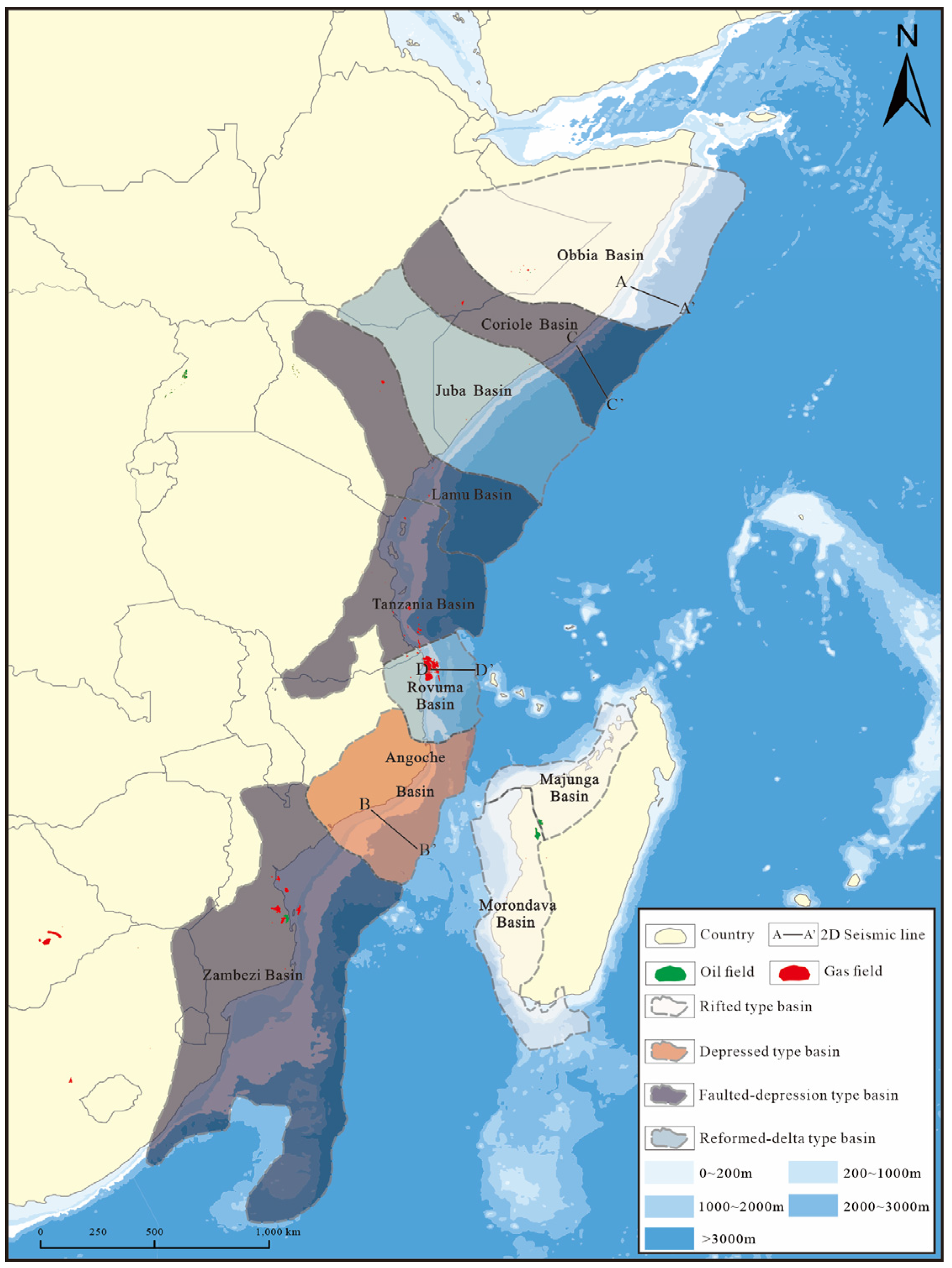
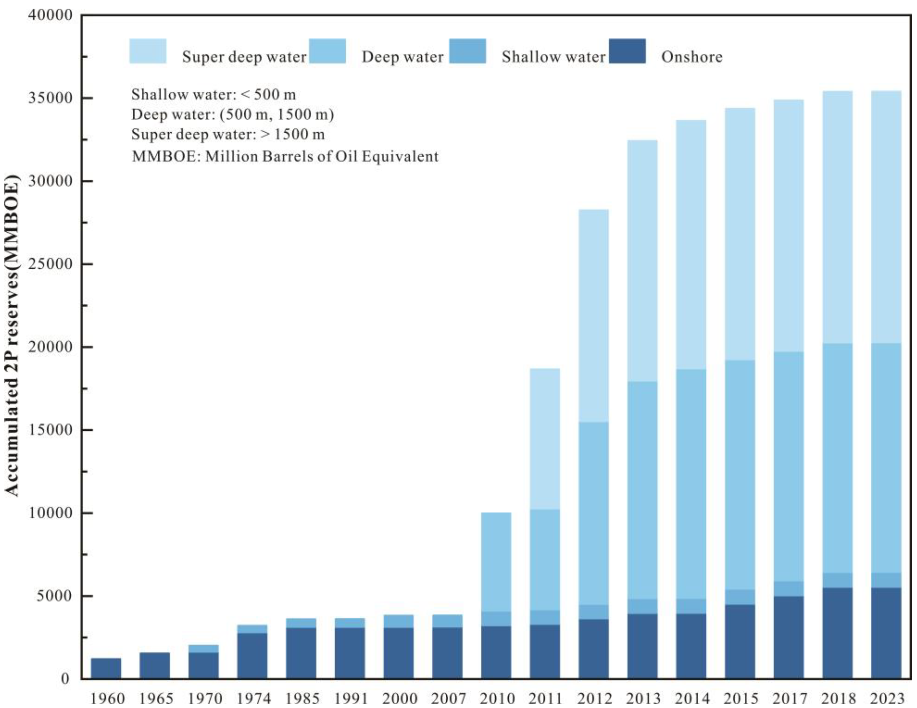
2. Exploration Overview in This Study Area
The passive continental margin basins in East Africa are located on the western margin of the Indian Ocean. They are a series of basins generated by the breakup of East Gondwana and the formation of the Indian Ocean since the Mesozoic period (
Figure 1). Geographically, they are from northernmost Somalia and Ethiopia to Kenya, Tanzania, Mozambique, and the periphery of Madagascar southwards, mainly including Obbia, Coriole, Juba, Lamu, Tanzania, Rovuma, Angoche, Zambezi, Morondava, and Majunga Basins, with a total sedimentary area of more than 3.7 × 10
6 km
2, of which 1.51 million km
2 is under 200 m water depth. These basins have a clear two-layer structure: the lower rift sequences include the Upper Carboniferous, Permian, Triassic, and Jurassic, mainly filled with terrestrial sediments; the upper depression sequences consist of the Cretaceous and Cenozoic strata, all of which are filled with marine sediments.
Exploration activities along the coast of East Africa started in the 1950s. Drilling activity began in 1958, and until 2010, a total of 232 wells had been drilled. However, the drilled wells in this stage were limited to onshore and shallow-water regions with a depth of less than 100 m, and the success rate of drilling was extremely low. A total of 33 large and medium-sized oil and gas fields were discovered in onshore and shallow-water areas in the Obbia Basin, Coriole Basin, Juba Basin, Zambezi Basin, Tanzania Basin, and Rovuma Basin, with a total of 2 P recoverable reserves of 1.43 billion barrels of oil and 48 TCF of natural gas. The Tsimiroro and Bemoolanga heavy oil and oil sand deposits were found onshore in the Morondava Basin, with estimated geological reserves of 2 billion barrels and 11 billion barrels, respectively. In August 2010, drilling began in the deep-water region, and 25 large and medium-sized gas fields were discovered in Blocks 1 and 4 of the Rovuma Basin and Blocks 1, 2, 3, and 4 of the Tanzania Basin, with a total of 143 TCF of new 2 P recoverable reserves, all located in deep and super-deep-water regions. Despite this, the exploration degree in the area is still very low, with all discoveries concentrated in the northern part of the Rovuma Basin and the slope of the Tanzania Basin. There are only 15 blocks with exploration wells at water depths greater than 200 m, with a total area of 130,000 km
2, accounting for less than 10% of the entire deep-water exploration area (
Figure 2).
4. Differences in Basin Architecture and Sedimentary Evolution
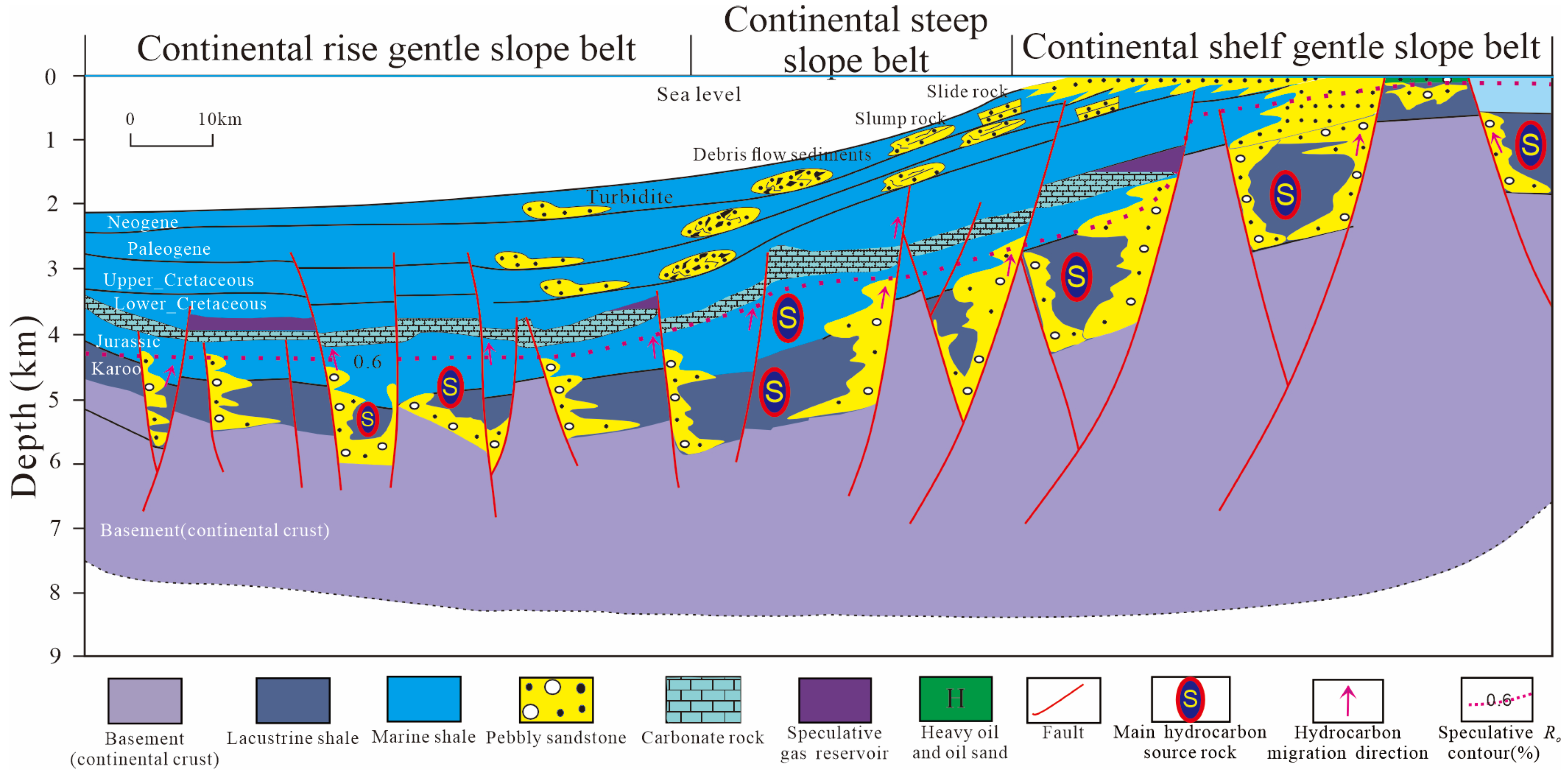
The passive continental margin basin generally has a basin architecture of “lower-rift and upper-depression,” that is, a sedimentary basin superimposed by the rift lacustrine basin sedimentation in the early rift period and the marine wedge-shaped “prism” sedimentation in the late passive drift period [
23]. Affected by the development characteristics of underlying rifts, the provenance topography of overlying depressions, and the sedimentary filling rate, the structural architecture characteristics of different basins vary greatly, and the sedimentary filling characteristics vary largely [
24]. “Differences in basin architecture and sedimentary evolution.” “This paper selects two-dimensional seismic profiles of different basins in this study area and selects a tectonically representative seismic profile for each type of basin. Based on this, the passive continental margin basins of East Africa are further divided into four subtypes: rifted type, depressed type, faulted depression type, and reformed delta type” (
Table 1). The following is an explanation of typical basins.
4.1. Rifted Basins
Rifted basins exhibit a “lower-rift and upper-depression” architecture, characterized by a basin architecture with thicker underlying rift sequences and thin overlying depression sequences. Taking the Obbia Basin as an example (
Figure 4), its overall characteristics are vertical stratification and horizontal zoning. There is a significant difference between the two sets of sequences (lower-rift and upper-depression) in the vertical direction: the underlying Karoo-Jurassic rift sequences are widely developed, with a thickness of over 3500 m; the extensional faults control the formation of alternated horst-graben structural features. The seismic reflection quality in the middle-lower parts of the rift sequences is generally poor, the basement reflection is not clear, and the “hill-shaped” seismic reflection characteristics above the upper horst-style fault block belong to carbonate sedimentary formation. Drilling reveals that the upper part is a continental fluvial-delta-lacustrine sedimentary system [
9]. The depression sequences overlying the rift sequences have obvious “wedge-shaped” characteristics, with underdeveloped faults and a regional angular unconformity contact with the underlying strata. The maximum total sedimentary thickness is less than 4000 m. The seismic reflection characteristics at the stratigraphic boundary are obvious: the seismic reflections in the lower part of the depression sequences exhibit weak amplitude and near-blank reflection architecture, and the major deposits during the transgression period are fine-grained sediments in deeper water. From the continental slope to the abyssal plain, multiple sets of small wedge-shaped seismic reflection architectures are developed in the middle and upper strata; the thickness from near-shore to far-shore changes from thinner to thicker, and the amplitude changes from stronger to weaker, belonging to the small delta-deepwater gravity flow sedimentary system.
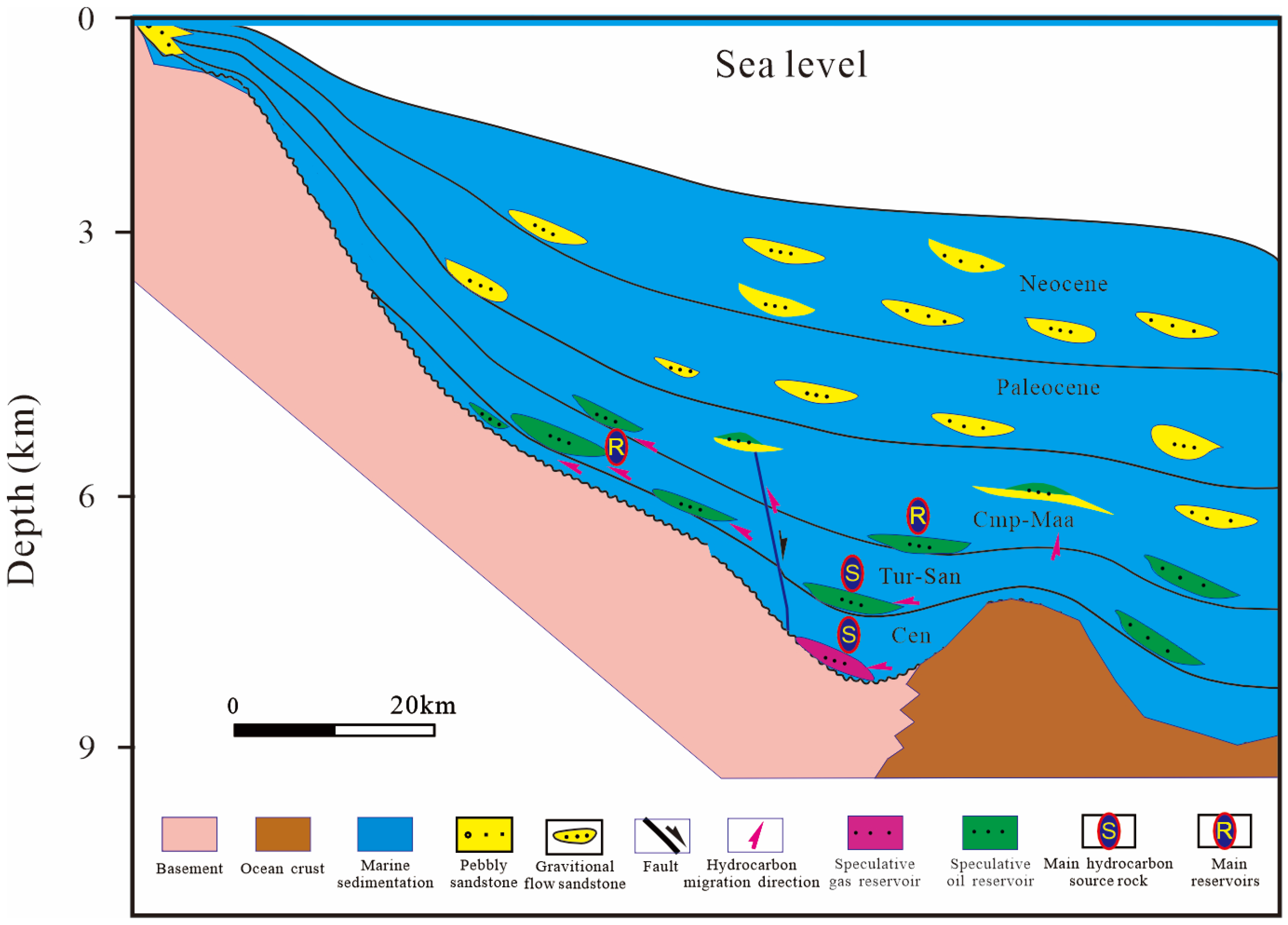
4.2. Depressed Basins
Compared with other types of basins, the formation of depressed basins is controlled by strike-slip transform faults with a unique architecture. Vertically, the development and distribution range of rift sequences are narrow, and the thickness of depression sequences is large. Horizontally, it displays the characteristics of a “narrow continental shelf and steep continental slope.”
Taking the Angoche Basin as an example (
Figure 5), the extension—strike-slip stress transformation caused by the Late Jurassic seafloor spreading made the East Gondwana and Madagascar separate from Africa along the SN-trending Davie Ridge and Mozambique Ridge and other transform faults, forming rifted basins with steep-dip boundary faults. After the evolution of rifts and passive continental margins, the Angoche Basin was formed under the control of strike-slip faults with steep dip angles. The Karoo-Jurassic rift sequences are narrow and deep, mainly filled with clastic deposits, and the overlying depression sequences of the drift period are thick, mainly filled with clastic deposits. Seismic data reveal that graben and half-graben units are distributed between rift and depression sequences, filled with wedge-shaped sediments. The seismic reflections in the rift sequences exhibit weak amplitude and near-blank architecture, and gravity flow deposits such as submarine fans are easily formed at the continental slope and continental uplift in the depression sequences. They are formed by the sand deposits on the basin coast collapsing along the steep slope under the disturbance of earthquakes, tsunamis, and other factors. It is speculated that they belong to the deep-water slip-collapse-debris flow-turbidity current sedimentary system [
25].
Horizontal east-west zoning: from west to east, according to the current stratigraphic dip, it can be divided into an upper gentle slope belt (less than 1°), a middle steep slope belt (1–4°), and a lower gentle slope belt (less than 2°), roughly corresponding to the continental shelf, continental slope, continental rise, and abyssal plain. The continental shelf area has the smallest sedimentary thickness and more faults, while the continental slope area has the largest sediment thickness, and the sedimentary characteristics of wedge-shaped deep-water gravity flow are obvious. Hence, it is speculated that slip-collapse-debris flow sediments are mainly distributed in this tectonic environment, and faults are not developed. The continental rise area has a larger sedimentary thickness, flat strata, and undeveloped faults. It is mainly characterized by parallel reflection architectures and is speculated to be dominated by turbidite, fine sandstone, and shale deposits.
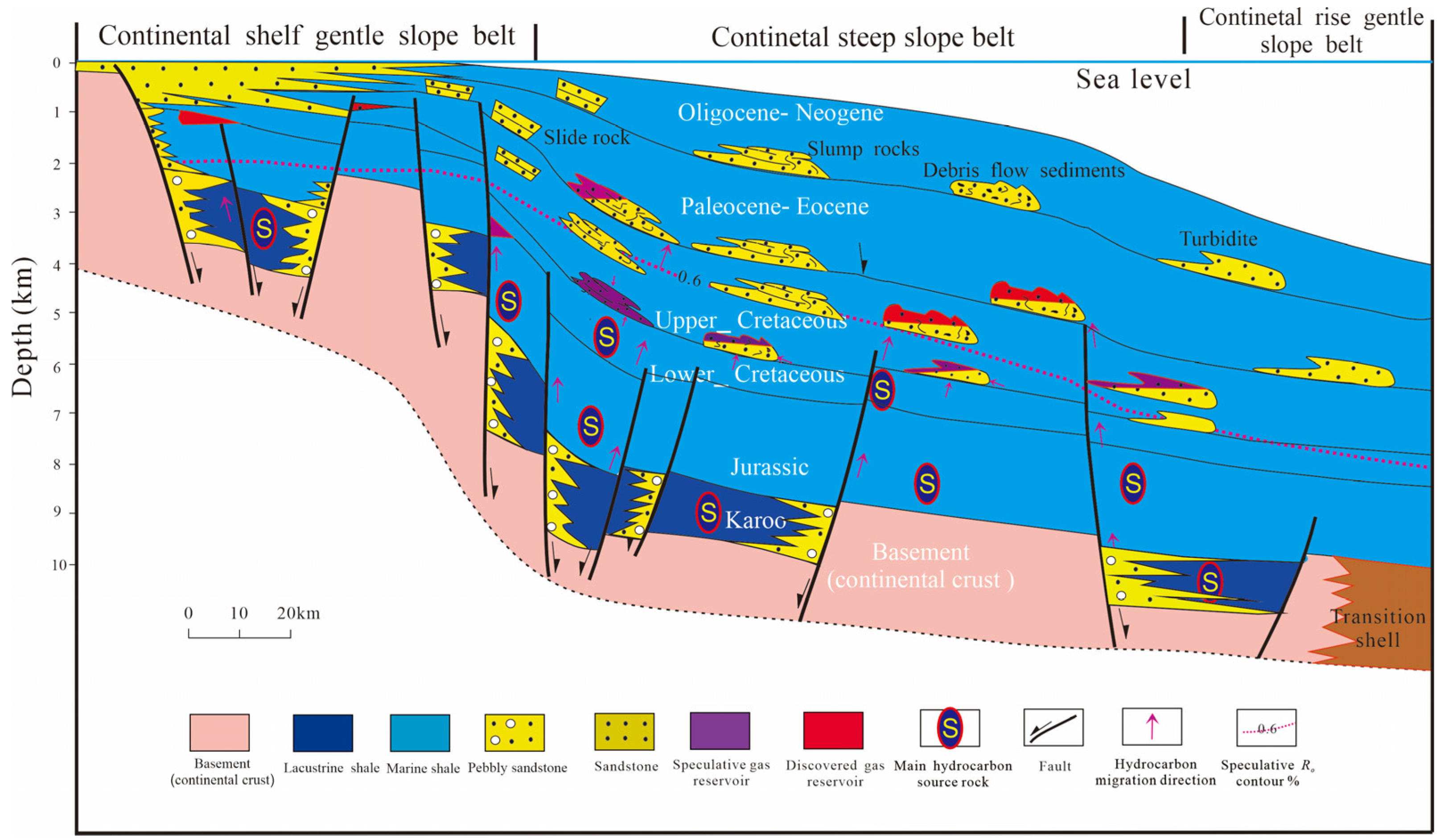
4.3. Faulted Depression Basins
The typical feature of a faulted depression basin is that both the rift sequences and depression sequences are well developed, and the thickness in the depocenter is relatively large. Taking the Coriole Basin as an example (
Figure 6), the overall structural architecture characteristics of the basin are similar to those of the Obbia Basin, and the characteristics of the lower intracontinental-intercontinental rift sequences are the same. The differences include: ① The overall thickness of the depression sequences during the upper drift period in the Coriole Basin is large, with a depocenter thickness exceeding 4000 m. ② Controlled by syngenetic dextral strike-slip faults, multiple sets of negative flower faults are developed at the continental slope and continental uplift regions. ③ During the depression period at the continental slope, faults inherit from the basement faults and are developed through the rift sequences. The extensional faults at the stratigraphic boundary control the formation of a structure with alternate graben and horst. ④ The overall characteristics from the continental shelf to the continental slope revealed by seismic facies are: the amplitude changes from stronger to weaker, the continuity changes from better to worse, the frequency changes from higher to lower, and the overall wedge-shaped characteristics are obvious. The upper continental slope is mainly massive transport and filling, while the lower continental slope is mainly composed of fan-shaped turbidite sand bodies [
26]. Since the Late Cretaceous, the wedge-shaped and lens-shaped strong reflection architectures reflecting deep-water sedimentary systems on the wide and gentle slope zone have increased in number and scale.
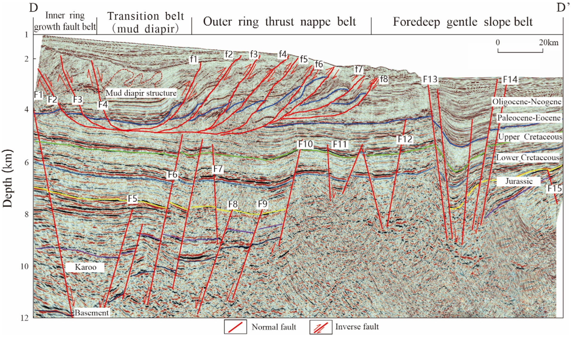
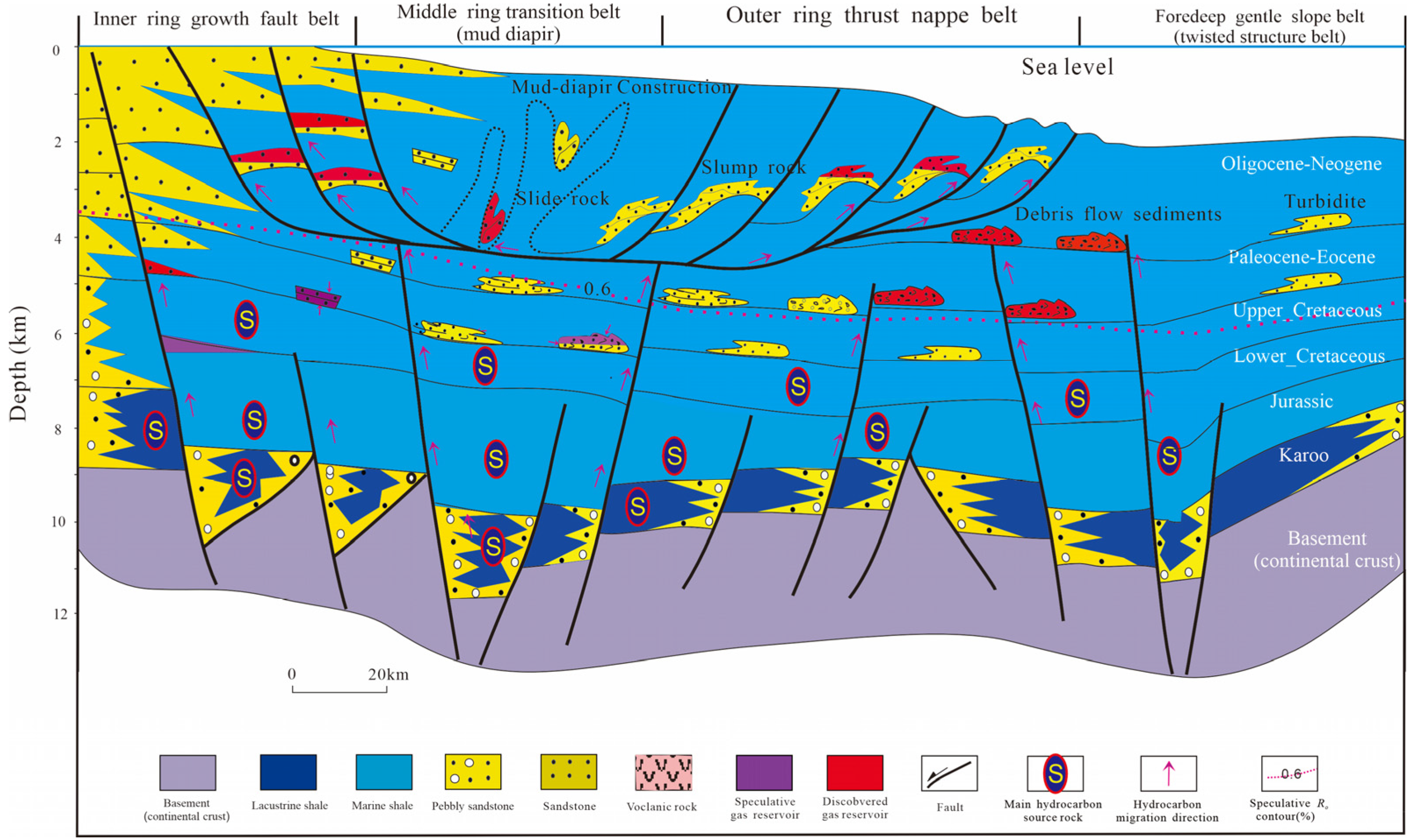
4.4. Reformed Delta Basins
The reformed delta basin is a passive continental margin basin with a ring structure belt after highly constructive delta reformation since the Miocene. It not only has a large sedimentary thickness; however, its own strata can form independent tectonic—sedimentary characteristics; and it has also reformed the original basin architecture.
Taking the Rovuma Basin as an example, this type of basin has the obvious characteristics of “vertical stratification and horizontal zoning” (
Figure 7). Vertically, it includes three sets of sequences, namely the lower rift sequences, the middle depression sequences, and the upper reformed delta sequences. The seismic reflection and sedimentary filling characteristics of the first two sequences are basically the same as those of the faulted depression basins. Since the Miocene, highly constructive deltas have developed in the upper part, and four ring structural belts, namely, the growth fault belt, plastic diapir belt, thrust fold belt, and foredeep gentle slope belt, are formed from onshore to offshore. Among them, the growth fault belt develops large-scale sand bodies in delta front subfacies, while the plastic diapir belt, the thrust fold belt, and the foredeep gentle slope belt are mainly gravity flow-induced collapse bodies, waterways, and submarine fans.
Since the Oligocene, with the decrease in global sea level, the supply of deposit sources in the continental shelf area has been sufficient, and the delta front sand bodies have gradually thickened. Moreover, the highly constructive progradation toward the sea led to an increase in the stratum slope. After the sedimentary sand bodies fall off vertically under the action of gravity, they expand downward along the slope. With the continuous progradation of the delta sand bodies, an inner ring growth fault belt can be formed on the foredeep facies belt, where the delta sand bodies are highly developed. Due to the increase in slope towards the sea, the sand bodies undergo gravity-sliding along the mudstone of the lower front delta. If the slope is large enough, the sand bodies will collapse and be transported in block form to the foot of the slope. During the transportation process, the uneven compaction of the lower mudstone forms a plastic diapir belt. Other sand bodies continue to move downward under the influence of gravity, forming thrust fold belts after the kinetic energy decreases [
14,
27]. A small amount of sand bodies are not captured by the thrust fold belt and deposited in the delta front gentle slope belt.
5. Hydrocarbon Accumulation Rules
Based on the above analysis, by integrating the architectural differences and sedimentary filling characteristics of the four types of basins, the hydrocarbon accumulation rules of each type of basin are further analyzed (
Table 2).
5.1. Rifted Basins
Rifted basins can form a “single-source structure type” hydrocarbon accumulation model (
Figure 8). In the Late Carboniferous-Triassic Karoo rift sequences, the source rocks of the onshore Tsimiroro heavy oil and Bemoolanga oil sands in the Morondava Basin have been confirmed to be lacustrine shale and swamp coal-bearing sequences, with the organic matter mainly of Type II and Type III, TOC value generally of 1–6%, hydrogen index (HI) of 17–750 mg/g, and the reservoir mainly of fluvial and delta clastic sandstone, with porosity generally of 12–30% [
20]. The source rocks of the Calub gas field and the Hilala gas field discovered in the Obbia Basin are mainly developed in two sets of rift sequences: ① Karoo Bokh shale has a high organic matter abundance, with a TOC value ranging from 0.5% to 17% and reaching a maximum of 27%. It is developed from medium to overly mature, with a maximum thickness of 450 m and a Ro of 1–1.3%. The organic matter is Type II, mainly generating gas; ② Lower Jurassic mudstone: it has a thickness of 50–120 m and organic matter of Type II and Type III. The reservoirs consist of Karoo fluvial-delta sand bodies and Jurassic lagoon carbonate rock, of which the grainstone and dolomite have better physical properties, with porosity between 10 and 26%. The source rocks of these two gas reservoirs mainly migrated vertically through faults and accumulated in the fault block traps of the Jurassic rift series. Since the Cretaceous, the sedimentary filling thickness in depressions has generally been less than 2500 m. Because the geothermal gradient is usually less than 35 °C/km, the source rocks have not yet entered the main hydrocarbon generation period, and they mainly act as regional cap rock, dominated by shale in the lake transgression period. The Late Cretaceous was the main period of hydrocarbon migration.
The only heavy oil and oil sands found in the Morondava Basin are located in the Karoo rift sequences, which belong to structural traps or structural-stratigraphic composite traps that were damaged during the late rising process. The common feature of oil and gas discoveries in the Morondava Basin and the Obbia Basin is that their source rocks and reservoirs belong to the Triassic lacustrine sedimentary sequences, and hydrocarbons are accumulated in faulted blocks or fault-stratigraphic composite traps on the slope belt of the faulted depression through vertical (fault) and horizontal (reservoir) migration paths. In addition to the faulted block gas reservoir formed by self-generation and self-storage during the Karoo period, the Jurassic gas reservoir also has oil and gas generated by the lower Karoo strata that migrate and accumulate vertically along faults, forming faulted block traps [
14]. Although the Cretaceous system itself does not have the ability to generate hydrocarbons, it cannot be ruled out that the hydrocarbons generated by the underlying two stages of rift sequences migrate along inherited faults into the Cretaceous gravity flow sand bodies (slip-collapse-debris flow), forming stratigraphic traps. This widely distributed inheriting fault provides the channel for upward migration of oil and gas vertically but destroys the connectivity of oil and gas migration and accumulation horizontally and limits the trap size. The Dohar and Shillabo gas fields in the Obbia Basin are also faulted block traps that generated hydrocarbons from the Karoo strata and migrated to the Jurassic strata.
The main exploration target of this type of basin is the structural play of two stages of rift sequences. Post-Cretaceous stratigraphy and composite traps can be considered in the presence of fracture verticals communicating with oil sources. Calub, Hilala, Shillabo, and Dohar gas fields in the Obbia Basin, and large Tsimiroro heavy oil and Bemoolanga oil sands discovered in the Morondava Basin, indicate that the rift sequences in this area have good exploration prospects. Moreover, Jurassic salt rock is developed in the northern Majunga Basin, and the structural plays of offshore subsalt rift sequences deserve attention. Overall, regardless of whether it is offshore or onshore, the main exploration targets for this type of basin are the structural traps (such as faulted blocks and anticlines) formed by the underlying two stages of rifts, as well as the stratigraphic traps of the depression stage, where faults communicate oil sources.
5.2. Depressed Basins
The depressed basins form a “single-source fan group type” hydrocarbon accumulation model (
Figure 9). The Karoo rift sequences in the Angoche Basin are not developed. The source rock is the Upper Jurassic—Upper Cretaceous strata; mainly marine mudstone and marine shale. The organic matters are Type II and Type III, with high organic matter abundance, TOC between 2 and 18%, geothermal gradient between 25 and 35 °C/km, and the major thermal model of 35 °C/km. In terms of reservoir, it has been confirmed that the onshore and shallow-water regions mainly develop Upper Cretaceous coastal and shallow sea sandstone, while the deep-water regions mainly develop sandstone and a small amount of carbonate rock. Benefiting from the development of modern water systems, the erosion of the Precambrian basement provides sufficient provenance. Two sets of deep-water gravity-flow sandstone reservoirs from the Cretaceous, Paleogene, and Neogene are developed in the deep-water region. Seismic data reveal that deep-water sedimentation is dominated by channels, slope fans, and basin floor fans. It is speculated that the traps of the Angoche Basin are mainly lithologic-structural composite traps, and the Cretaceous and Paleogene deep-water sandstone plays are generally developed in the basin. Due to the lack of inherited growth faults in the lower rifts, both the upper and lower transverse rifts and the upper depressions have good oil and gas connectivity.
The main exploration target of this type of basin is mainly the depression sequences since the Cretaceous, and the main target is the large lithologic plays formed by the deep-water gravity flow sand bodies of the Upper Cretaceous.
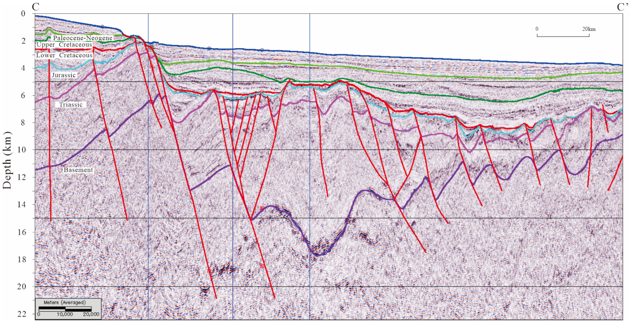
5.3. Faulted Depression Basins
Faulted depression basins can form a “double-source and double-combination type” hydrocarbon accumulation model (
Figure 10). In addition to the structural plays formed in rift sequences, the hydrocarbons generated by marine source rock in depression sequences can directly migrate to the stratigraphic traps related to deep-water gravity flow sand bodies to accumulate, and the upper and lower sets of source rocks can supply hydrocarbons to the sand bodies of the same depression sequence to form reservoirs.
Taking the Tanzanian Coast Basin as an example, in addition to the two stages of rifting source rocks that have been confirmed to be the same as those in the above rifted basins, there is effective source rock in the Lower Cretaceous in the depression sequences. At present, it is confirmed that the Lower Cretaceous source rock is mainly of Type III, with a TOC value between 1–7.4%, a HI value of 17–688 mg/g, and a Ro value of 1.2%. The reservoir is mainly composed of shallow sea, delta, and gravity flow clastic sandstones, with porosity generally between 12 and 30%. The cap rock is transgressive shale, and the traps include faulted blocks and composite traps. The source rock of the onshore EI Kuran gas field discovered in the Coriole Basin is Jurassic Hamanlei shale, which is generally less than 3 m thick. It reached the peak of hydrocarbon generation during the Oligocene. Most structures had been formed during the Late Cretaceous—Paleogene. It is speculated that hydrocarbons had been generated at this time, and the geothermal gradient was generally lower (<15 °C/km). Its reservoir is the Middle-Upper Jurassic Hamanlei carbonate rock, in which the grainstone and dolomite have good physical properties. The Hamanlei reservoir is sealed by the shales of the Hamanlei and Uarandab Formations, with good regional scope and sealing capacity.
In terms of hydrocarbon accumulation characteristics, the only effective source rock in the gentle slope belt of the upper shelf (onshore—shallow water) was deposited during the rift period. If the faults are connected, various related faulted block traps can be formed in the rift sequences and depression sequences. The discovered Song Song gas field has confirmed that hydrocarbons from the Jurassic source rock migrated along faults to the lower Cretaceous shore-shallow sea sandstone, forming a faulted block trap. It is speculated that larger slip-collapse-related stratigraphic traps can be formed in the upper part of the continental steep slope belt; in the lower part of the continental steep slope belt, the major traps are stratigraphic and composite traps related to deep-water gravity flow sedimentation (presumably dominated by clastic flow rocks). At present, 10 gas fields discovered in Blocks 1–4 of Tanzania, ranging from the Upper Cretaceous to the Miocene, all belong to the lower composite trap of the steep slope belt. At present, there are no drilled wells on the gentle slope of the lower continental rise. Seismic data reveal that there are more submarine fans (mainly turbidite deposits), thus it has the conditions to form large-scale lithologic traps. Due to the stable geological environment and abundant source supply in the passive continental margin of East Africa, the clastic flow rock deposits (mainly sandstone) eventually developed into large and medium-sized fans, which can be used as high-quality oil and gas accumulation zones. Because the fault of the lower rift layer does not break through the upper depression, the oil and gas connectivity of the rift layer is poor, and the oil and gas connectivity of the depression sequences is good.
Different trap types can be found in different structural belts of such basins. The onshore-shallow-water area is dominated by structural traps of rift sequences. The main exploration target in the continental slope area is slope fans formed by large-scale sliding collapses. The lower part of the continental slope should focus on lithologic traps formed by fans in mature source rocks. The main exploration target in the continental rise area is the submarine fan, which is connected to the source rock by a fault and has good hydrocarbon accumulation conditions.
5.4. Reformed Delta Basins
Due to its unique structural architecture characteristics, this type of basin has a “multi-source and multi-combination type” hydrocarbon accumulation model (
Figure 11). Taking the Rovuma Basin as an example, the passive continental margin drift stage since the Cretaceous is characterized by the formation of open sea. The continental coast rivers with varying sizes bring terrestrial organic matter to the sea to be rapidly deposited and preserved, forming the organic matter dominated by Type III kerogen, with HI generally lower than 250 mg/g and TOC between 0.3 and 12.2%. In addition to the drift sequences rich in organic matter that mainly generate gas, the source rocks of the underlying two periods of rift sequences still mainly supply natural gas upwards due to the large overlying sedimentary thickness (generally 4000–7000 m) and high geothermal gradient (average more than 30 °C/km), with thermal evolution at the highly mature to overly mature stage. The reservoirs consist of marine clastic rock and carbonate rock. The former reservoirs are sand bodies in coast, delta, and turbidite channel facies with good physical properties and a maximum porosity of up to 30%. The latter reservoirs have been confirmed to be a few dolomite reservoirs. The cap rocks have been confirmed to be all marine shale, among which the interlayer shale in the Paleogene is the main cap rock for discovered deep-water oil and gas, and the thick rock salt of the Lower Jurassic can serve as a potential cap rock [
17]. In addition to the widely developed effective source rocks in the underlying two periods of rift sequences and the Lower Cretaceous, the marine source rocks of the Upper Cretaceous—Paleogene have also basically entered the oil generation threshold. In terms of reservoir types, except for the same type as the “faulted depression type” basins mentioned above, the delta sedimentary sequences and the foredeep gravity flow sand bodies are all high-quality reservoirs, and transgressive shale can effectively seal hydrocarbons regionally.
In addition to the rift and depression sequences that can form the same plays as “faulted depression type” basins, the four major ring structural belts formed on the plane of the delta sequences have unique hydrocarbon accumulation characteristics. Taking the Rovuma Basin as an example, multiple sets of ultra-large gas-rich gravity flow sedimentary sand bodies are developed in the ultra-deep-water region of the basin. One faulted block trap has been found on the inner ring growth fault belt, and a large traction anticline gas reservoir has been discovered in the outer thrust fold belt. While in the foredeep gentle slope belt, 11 large gas fields have been found in the slope fan that may belong to debris flow, with recoverable reserves of more than 130 TCF, mainly distributed in the Paleogene. Its offshore exploration degree is relatively higher, and several commercial gas fields (such as Golfinho, Atum, and Tubarao Tigre) have been successively discovered. The Windjammer well encountered 23 m and 146 m of gas layers in Paleocene and Oligocene, respectively, and the reason for such rich oil and gas is due to its favorable accumulation conditions. The source rocks of the three prototype basins may provide oil and gas sources, and the resources are abundant. Large delta sand bodies and turbidite sand bodies not only form excellent reservoirs but also large traps such as rolling anticline, compressive anticline, and stratigraphic structure, which can develop into extremely thick Marine drift layers over a long period of time. Due to the formation and regression of the sea, multiple sets of favorable reservoir-cap assemblages can be formed, and the preservation conditions are obviously better than the two underlying rifts, and oil and gas enrichment is inevitable.
In addition to the Rovuma Basin, the East African sea area also develops the Juba Basin in the south of Somalia. This basin has a low exploration degree; however, it has the same stratigraphic filling as the Coriole Basin in the north. It is speculated that they have similar hydrocarbon accumulation conditions. Paleogeographic research shows that there are more Paleocene—early Pliocene—delta and turbidite sand bodies in the sea area of the Juba Basin. Because there have been more delta sand bodies with large thickness since the Oligocene, which is equivalent to the Niger Delta Basin in West Africa, the favorable exploration direction of this type of basin is the four types of structural belts formed by the delta sequences.