
The Influence of Vegetation Cover on the Settlement Behavior of Permafrost Subgrade in the Greater Khingan Mountains Forest Region

Abstract
:1. Introduction
2. Materials and Methods
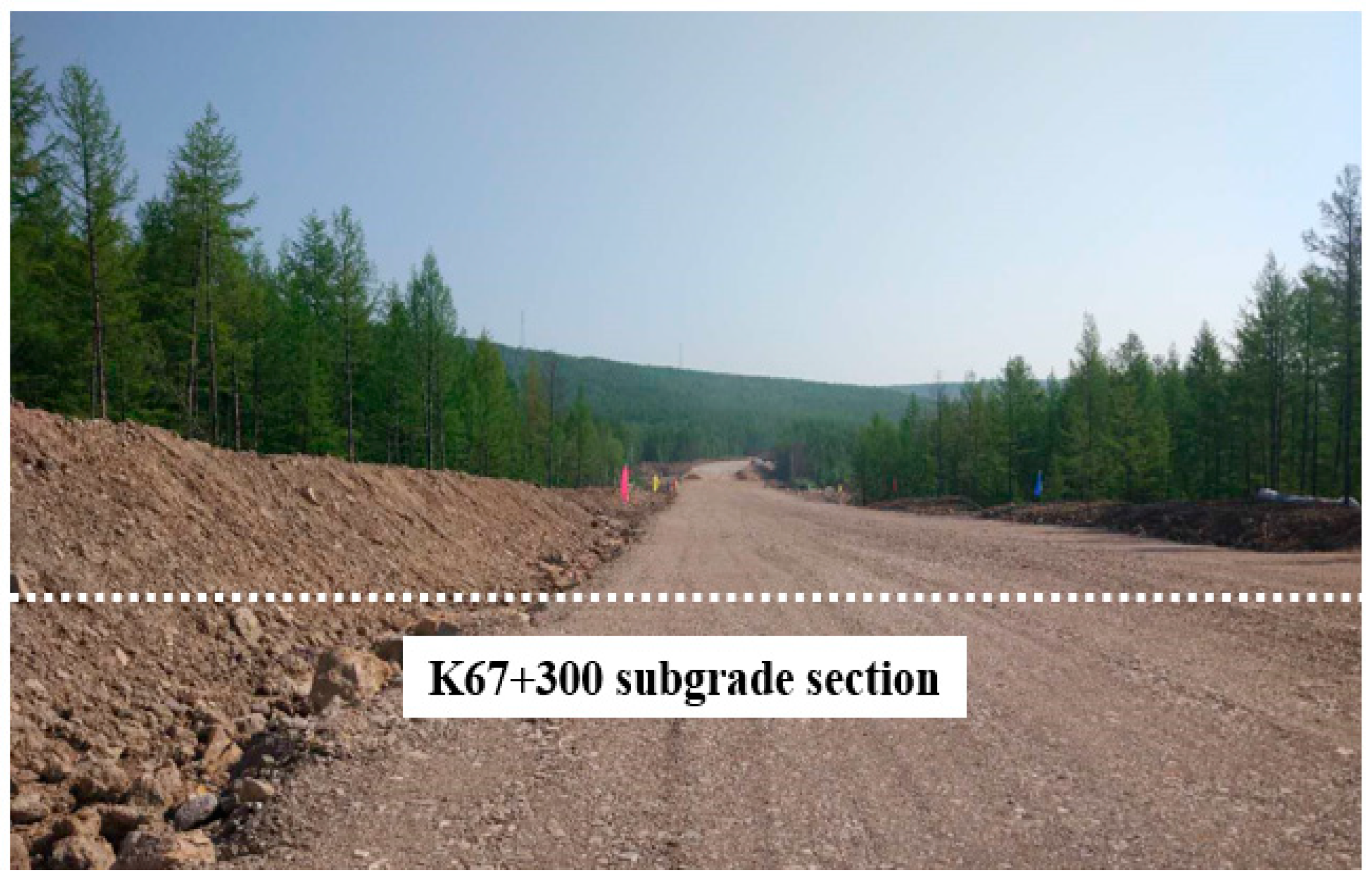
2.1. Study Region
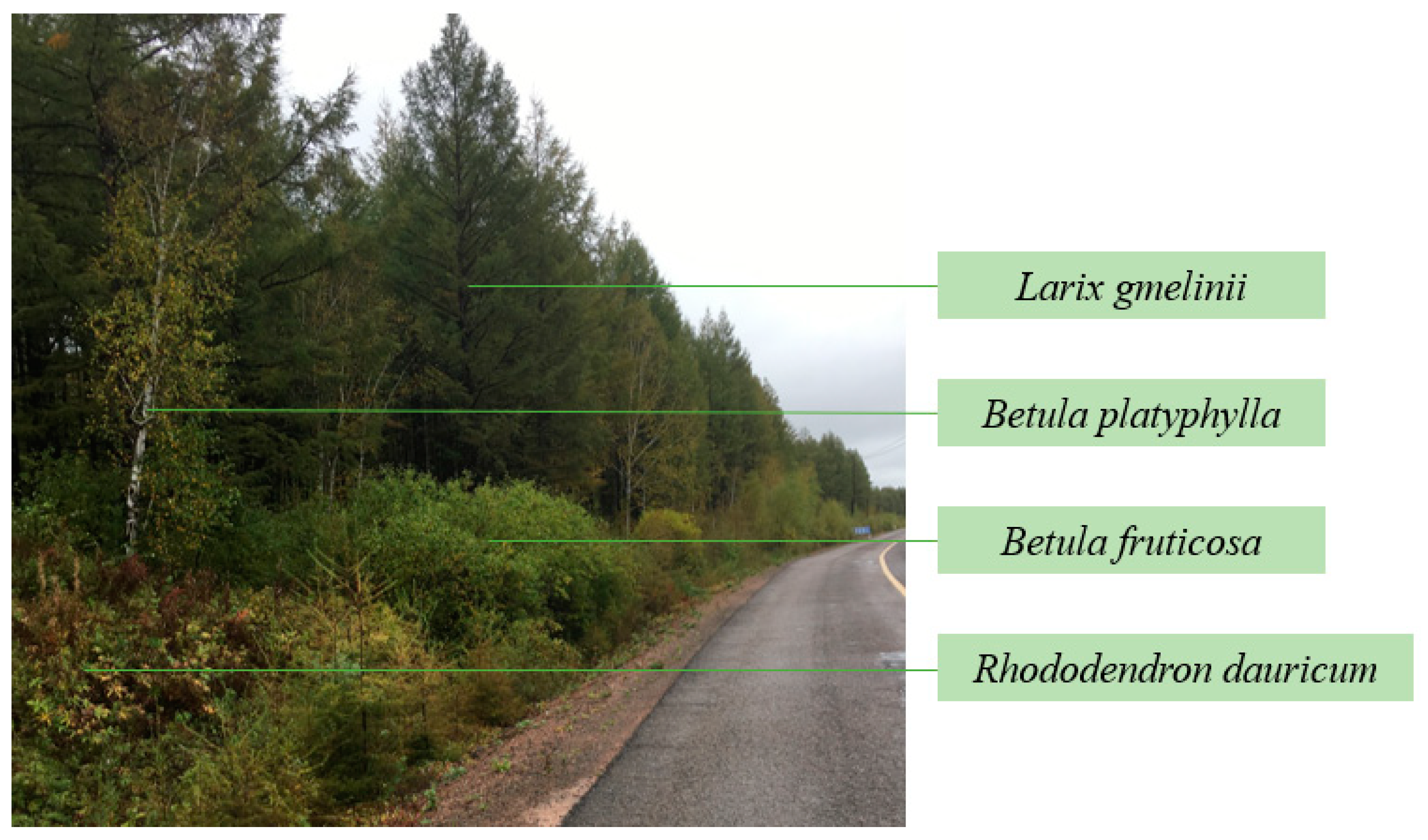
2.2. Vegetation
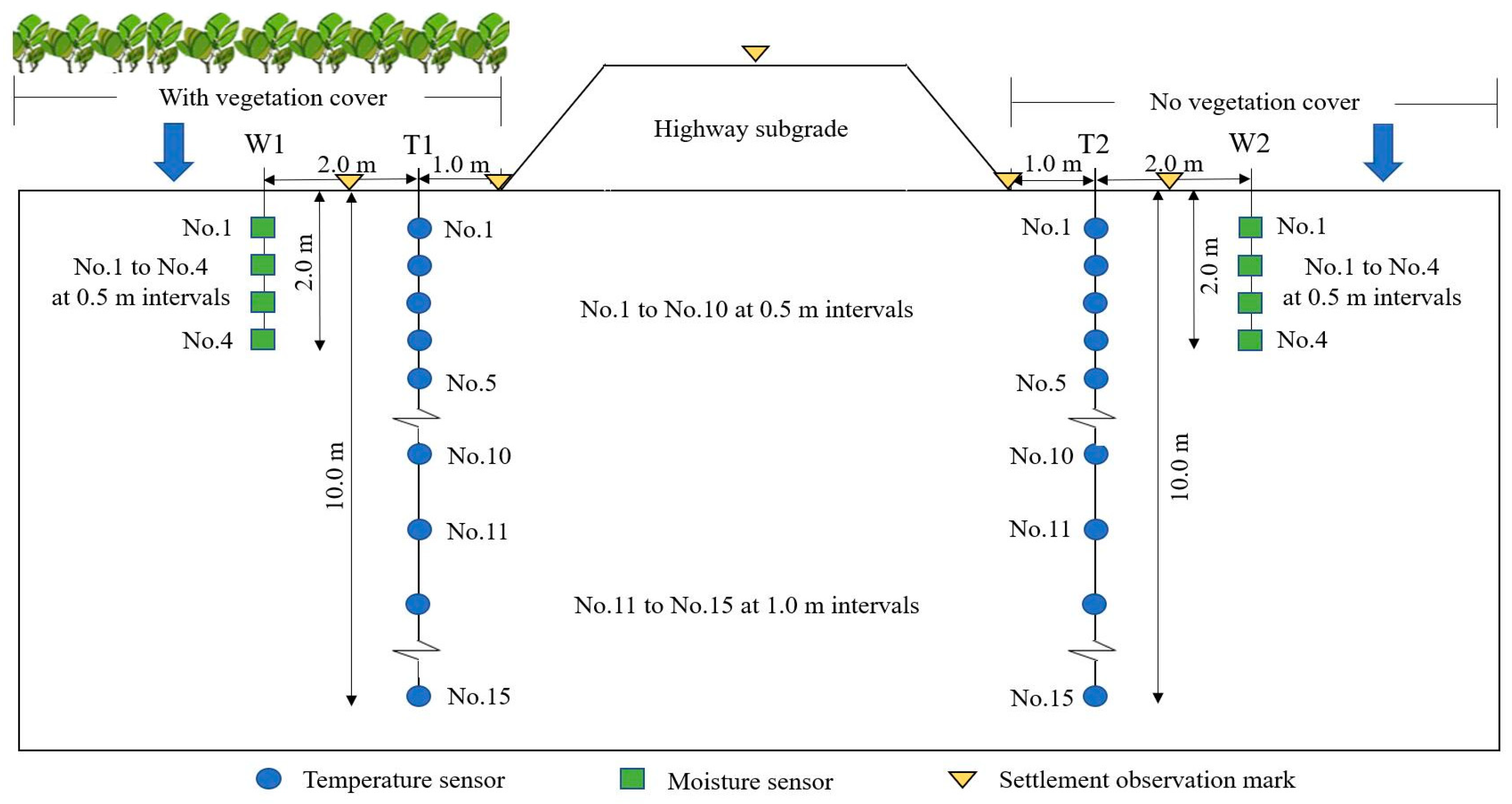
2.3. Field Observation Methods
2.4. Establishment of Permafrost Subgrade Model in ABAQUS
3. Results
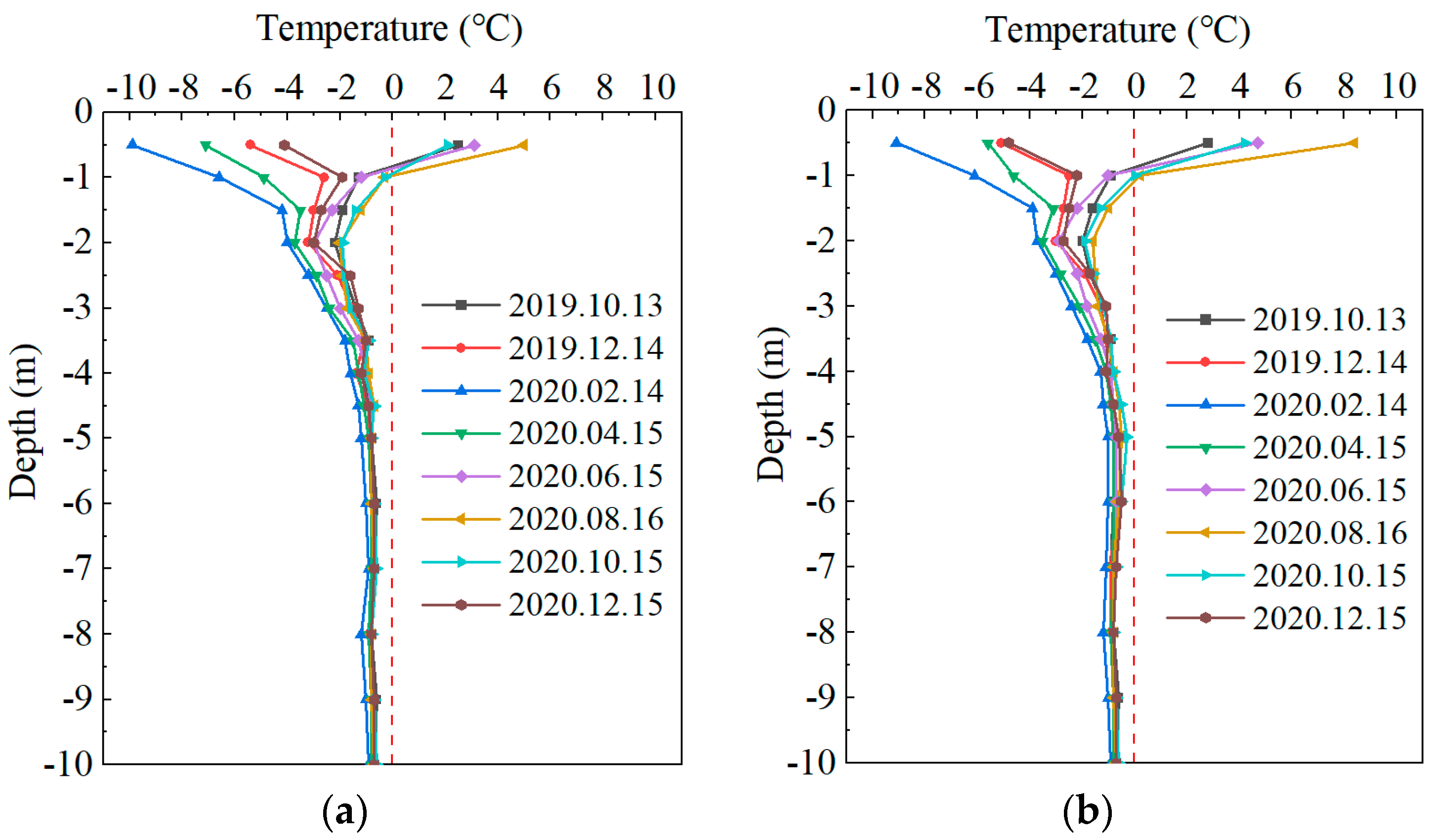
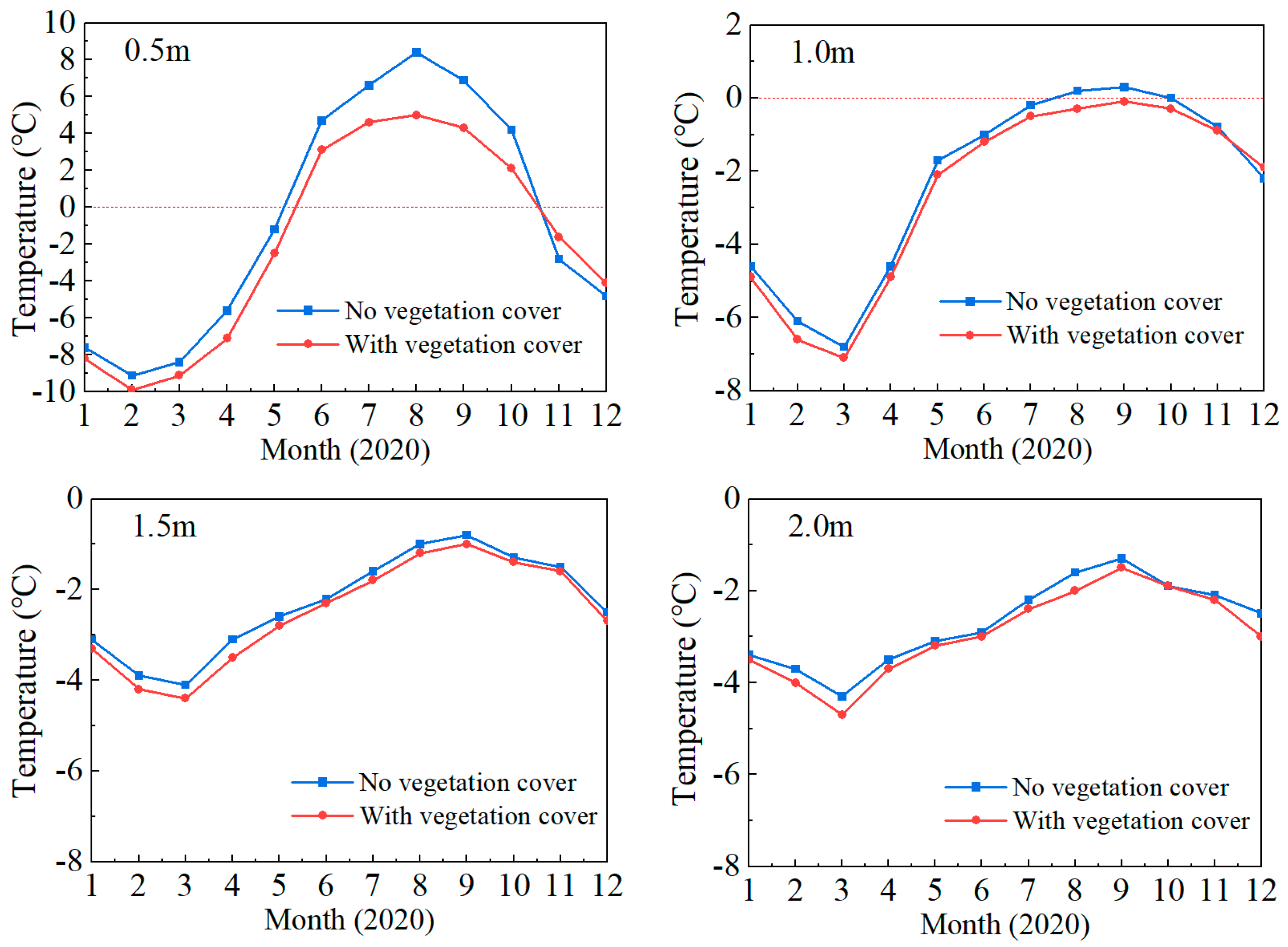
3.1. Temperature Variation Regularity of K67+300 Subgrade Section
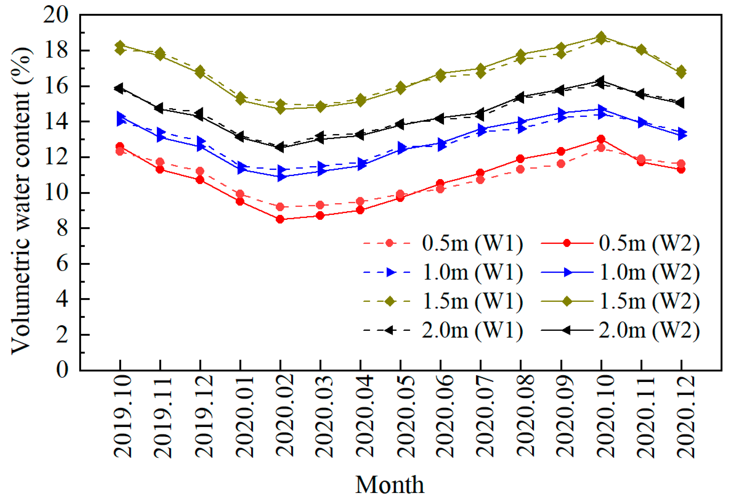
3.2. Moisture Variation Regularity of K67+300 Subgrade Section
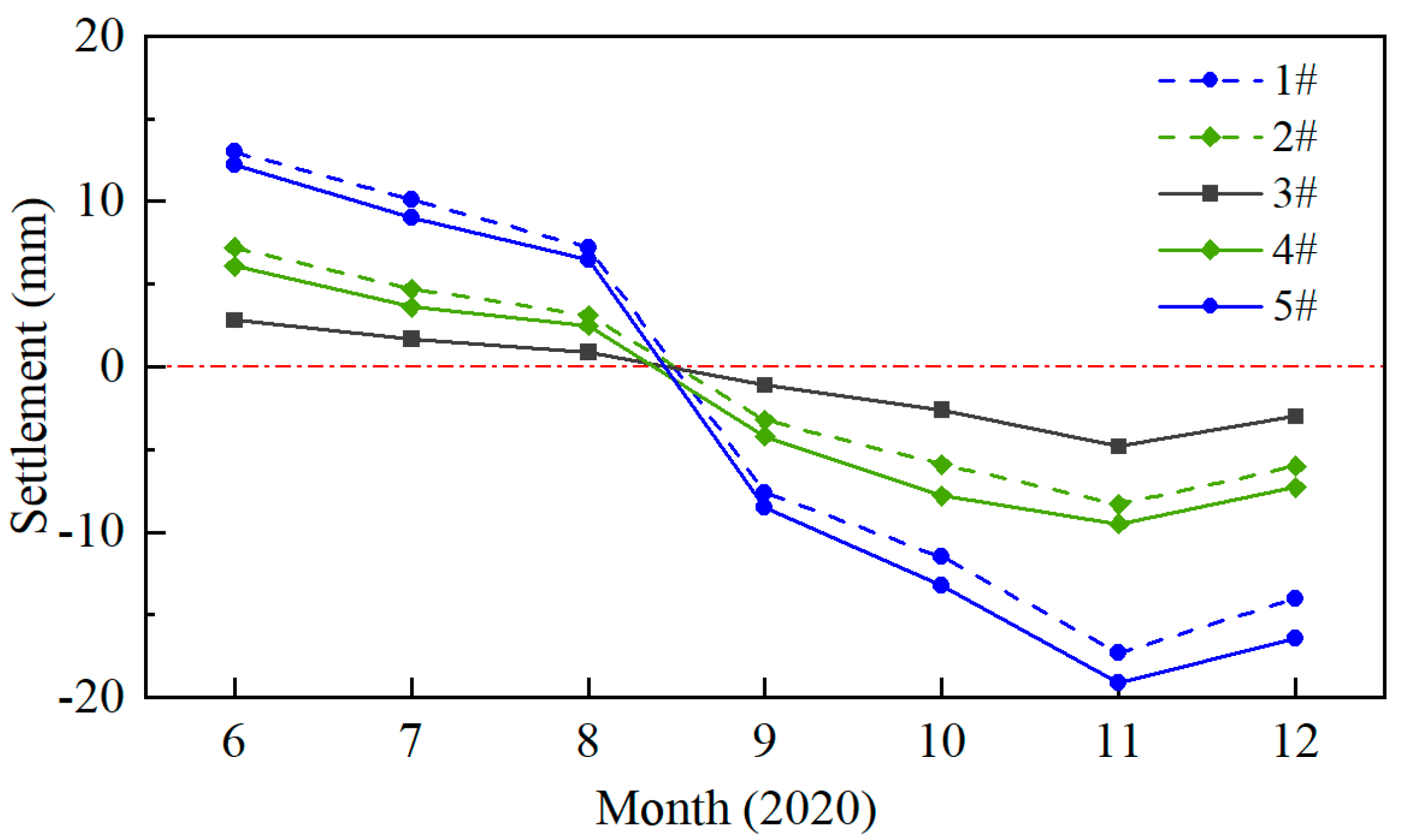
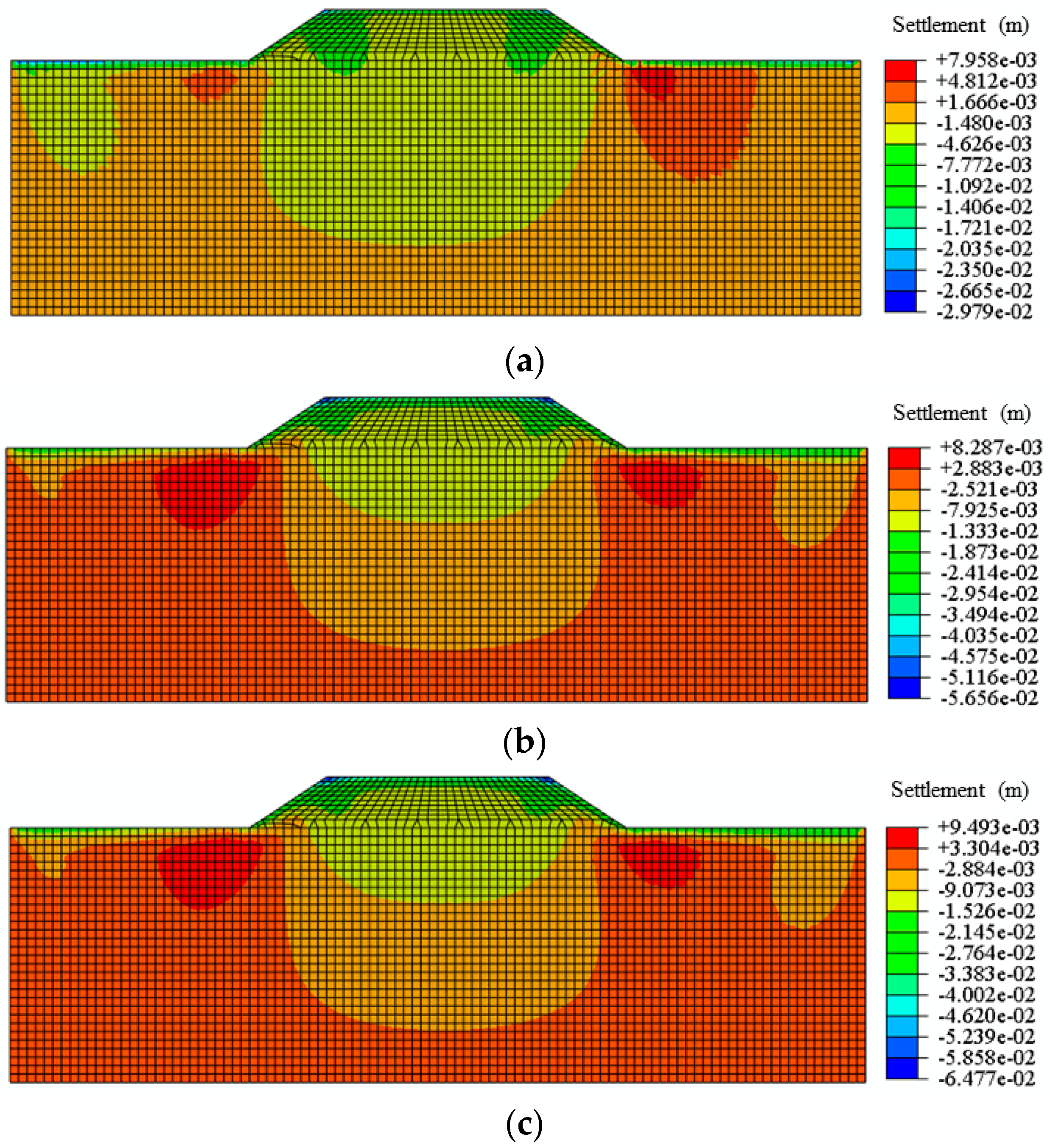
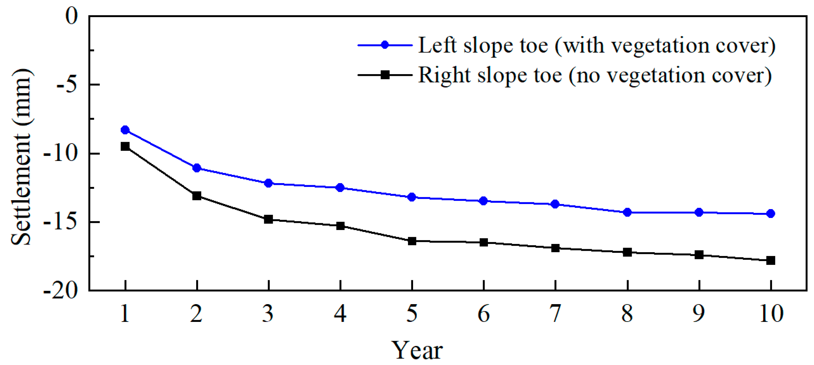
3.3. Settlement Variation Regularity of K67+300 Subgrade Section
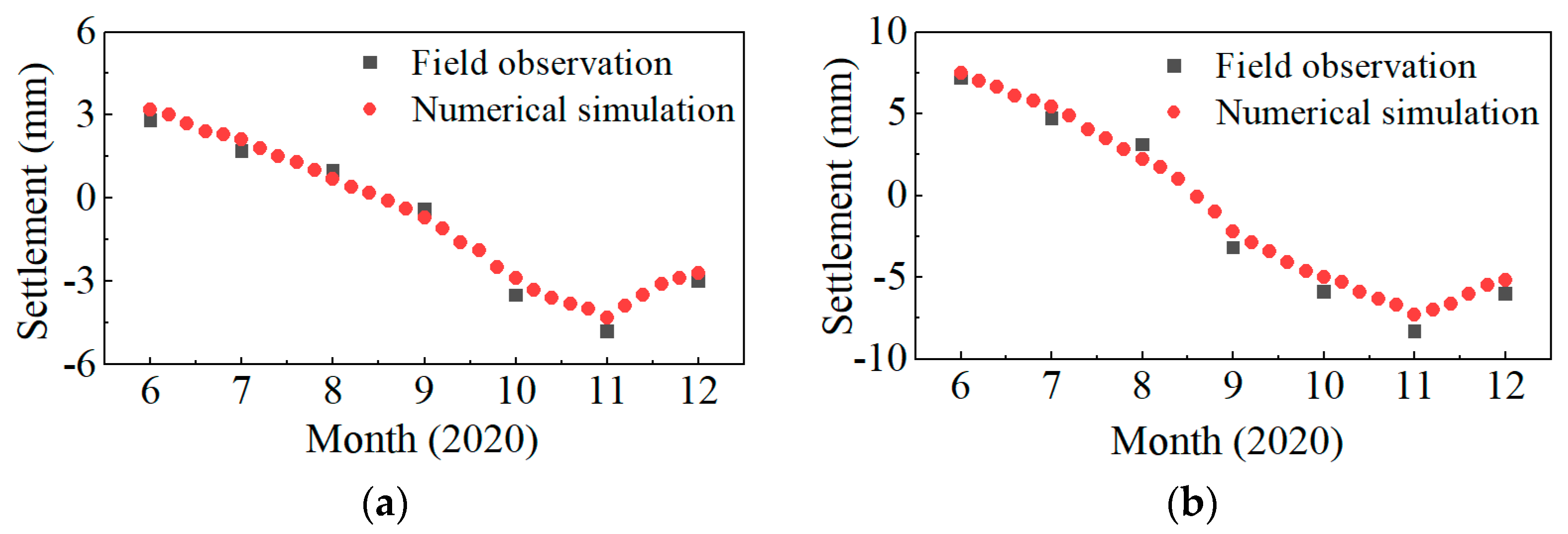
3.4. Numerical Model Validation
4. Discussion
5. Conclusions
- (1)
- In the forest region of the Great Khingan Mountains, the underground temperature reaches its lowest value in March and the highest value in September. Vegetation cover mainly influences the seasonal active layer temperature of permafrost and its cooling effect on permafrost in the warm season is more significant compared with the warming effect in the cold season.
- (2)
- The volumetric water content of underground rock and soil mass reaches the maximum when the underground depth is 1.5 m. At the same depth, the volumetric water content of the subgrade with vegetation cover is greater than that without vegetation cover in the cold season. The situation is just the opposite in the warm season.
- (3)
- The closer to the center of the subgrade, the smaller the magnitude of subgrade freeze–thaw deformation. The damage to the subgrade is mainly reflected in the settlement caused by the thawing of frozen soil. The maximum settlement of the subgrade with and without vegetation cover is 8.3 mm and 9.5 mm at the foot of the subgrade slope, respectively. After construction, the settlement behavior of the permafrost subgrade will undergo a degradation period of 3 years, a restoration period of 2 years, and finally, tend to be stable.
Author Contributions
Funding
Institutional Review Board Statement
Informed Consent Statement
Data Availability Statement
Acknowledgments
Conflicts of Interest
References
- Dobinski, W. Permafrost. Earth Sci. Rev. 2011, 108, 158–169. [Google Scholar] [CrossRef]
- Liu, G.; Zhang, B.; Wang, L.; Wu, X. Permafrost region and permafrost area in the Globe and China. Earth Sci. 2022, 1–18. [Google Scholar] [CrossRef]
- Jiang, H.; Niu, F.; Ma, Q.; Jiang, W.; Hu, H.; Wang, E.; Jiao, C. Thermal characteristics investigation of a high-speed railway tunnel by field monitoring in Northeast of China. Transp. Geotech. 2021, 30, 100615. [Google Scholar] [CrossRef]
- Gao, H.; Sa, C.; Meng, F.; Luo, M.; Wang, M. Temporal and spatial characteristics of permafrost on Mongolian Plateau from 2003 to 2019. J. Arid Land Resour. Environ. 2022, 36, 99–106. [Google Scholar] [CrossRef]
- Gong, T.; Gao, B.; Ji, Z.; Cao, H. Variation of active layer thickness of permafrost in the Qinghai-Tibetan Plateau based on MODIS temperature product. Sci. Geogr. Sin. 2022, 42, 1848–1856. [Google Scholar] [CrossRef]
- Zhang, Y.; Tie, N.; Chang, X. Effects of permafrost activity on growth and undergrowth of larch in the Greater Khingan Mountains. For. Resour. Manag. 2021, 137–144. [Google Scholar] [CrossRef]
- Zhao, Y.; Feng, J.; Liu, K.; Wu, Q.; Wang, L.; Liu, H. Freeze-thaw stability analysis of the high-ice content soil-rock cutting slope: A case study in Oroqen Autonomous Banner, North China. Geofluids 2020, 2020, 8825007. [Google Scholar] [CrossRef]
- Dong, X.; Liu, C.; Li, M.; Ma, D. Variations in active layer soil hydrothermal dynamics of typical wetlands in permafrost region in the Great Hing’an Mountains, northeast China. Ecol. Indic. 2021, 129, 107880. [Google Scholar] [CrossRef]
- Rui, D.; Ji, M.; Nakamur, D.; Suzuki, T. Experimental study on gravitational erosion process of vegetation slope under freeze–thaw. Cold Reg. Sci. Technol. 2018, 151, 168–178. [Google Scholar] [CrossRef]
- Nitzbon, J.; Westermann, S.; Langer, M.; Martin, L.C.P.; Strauss, J.; Laboor, S.; Boike, J. Fast response of cold ice-rich permafrost in northeast Siberia to a warming climate. Nat. Commun. 2020, 11, 2201. [Google Scholar] [CrossRef]
- Park, K.; Kim, Y.; Lee, K.; Kim, D. Development of a Shallow-Depth Soil Temperature Estimation Model Based on Air Temperatures and Soil Water Contents in a Permafrost Area. Appl. Sci. 2020, 10, 1058. [Google Scholar] [CrossRef]
- Schuur, E.A.G.; McGuire, A.D.; Schädel, C.; Grosse, G.; Harden, J.W.; Hayes, D.J.; Hugelius, G.; Koven, C.D.; Kuhry, P.; Lawrence, D.M.; et al. Climate change and the permafrost carbon feedback. Nature 2015, 520, 171–179. [Google Scholar] [CrossRef]
- Fedorov, A.N.; Konstantinov, P.Y. Response of permafrost landscapes of Central Yakutia to current changes of climate, and anthropogenic impacts. Geogr. Nat. Resour. 2009, 30, 146–150. [Google Scholar] [CrossRef]
- Turetsky, M.R.; Abbott, B.W.; Jones, M.C.; Anthony, K.W.; Olefeldt, D.; Schuur, E.A.G. Permafrost collapse is accelerating carbon release. Nature 2019, 569, 32–34. [Google Scholar] [CrossRef] [PubMed]
- Wen, L.; Guo, M.; Huang, S.; Yu, F.; Zhong, C.; Zhou, F. The response of vegetation to the change of active layer thickness in permafrost region of the north Greater Khingan Mountains. J. Glaciol. Geocryol. 2021, 43, 1531–1541. [Google Scholar] [CrossRef]
- Chang, X.; Tie, L.; Jin, H.; He, R.; Li, X.; Wang, Y. The features of permafrost in Xinlin forest area on eastern slope of the Greater Khingan Mountains. J. Glaciol. Geocryol. 2020, 42, 823–833. [Google Scholar] [CrossRef]
- Guo, W.; Liu, H.; Anenkhonov, O.A.; Shangguan, H.; Sandanov, D.V.; Korolyuk, A.Y.; Hu, G.; Wu, X. Vegetation can strongly regulate permafrost degradation at its southern edge through changing surface freeze-thaw processes. Agric. For. Meteorol. 2018, 252, 10–17. [Google Scholar] [CrossRef]
- Liu, Z.; Chen, B.; Wang, S.; Wang, Q.; Chen, J.; Shi, W.; Wang, X.; Liu, Y.; Tu, Y.; Huang, M.; et al. The impacts of vegetation on the soil surface freezing-thawing processes at permafrost southern edge simulated by an improved process-based ecosystem model. Ecol. Modell. 2021, 456, 109663. [Google Scholar] [CrossRef]
- Jia, Y.; Chen, S.; Wu, M.; Gu, Y.; Wei, P.; Wu, T.; Shang, Z. Improved permafrost stability by revegetation in extremely degraded grassland of the Qinghai-Tibetan Plateau. Geoderma 2023, 430, 116350. [Google Scholar] [CrossRef]
- Szymański, W.; Jagi, K.; Drewnik, M.; Musielok, Ł.; Stolarczyk, M. Impact of tundra vegetation type on topsoil temperature in central Spitsbergen (Svalbard, High Arctic). Geoderma 2022, 428, 116196. [Google Scholar] [CrossRef]
- Zhao, Y.; Liu, K.; Liu, H.; Xu, H. Study on stability analysis of soil-rock-mixture slopes under freeze-thaw erosion in Greater Khingan Mountains. Lithosphere 2022, 2022, 6936421. [Google Scholar] [CrossRef]
- Yan, B.; Cheng, R.; Xie, H.; Zhang, X. Temperature load mode of bridge in permafrost region of Qinghai–Tibet railway. Appl. Sci. 2022, 12, 4377. [Google Scholar] [CrossRef]
- Permyakov, P.P.; Zhirkov, A.F.; Varlamov, S.P.; Skryabin, P.N.; Popov, G.G. Numerical Modeling of Railway Embankment Deformations in Permafrost Regions, Central Yakutia. In Transportation Soil Engineering in Cold Regions, Volume 2: TRANSOILCOLD 2019; Springer: Singapore, 2020; pp. 93–103. [Google Scholar] [CrossRef]
- Xu, L.; Kang, H.; Pan, M.; Han, F.; Shen, Y.; Yu, W.; Zhang, X. Characteristics analysis of extremely cold weather in the Greater Khingan Mountains region. J. Glaciol. Geocryol. 2022, 44, 1748–1756. [Google Scholar] [CrossRef]
- Guo, J.; Han, F.; Bu, R.; Hu, Y.; Ma, J.; Nie, Z.; Zhu, J.; Ren, B. Classification of plant communities and species diversity responses to changes in the permafrost depths of the north slope of the Great Khingan Mountain valley of Northeast China. Acta Ecol. Sin. 2016, 36, 6834–6841. [Google Scholar] [CrossRef]
- Guo, D.; Wang, H. Permafrost degradation and associated ground settlement estimation under 2 °C global warming. Clim. Dyn. 2017, 49, 2569–2583. [Google Scholar] [CrossRef]
- Shan, W.; Ma, M. Numerical analysis of the influence of block-stone embankment filling height on the water, temperature, and deformation distributions of subgrade in permafrost regions. Water 2022, 14, 1382. [Google Scholar] [CrossRef]
- Chen, Z.; Li, S.; Xia, J.; Zhang, X.; Gui, C. Calculation of frozen soil thermal parameters considering unfrozen water content. Rock Soil Mech. 2017, 38, 67–74. [Google Scholar] [CrossRef]
- Luan, X.; Han, L. Variation mechanism and prediction of soil–water characteristic curve parameters of low-liquid-limit silty clay under freeze–thaw cycles. Appl. Sci. 2022, 12, 10713. [Google Scholar] [CrossRef]
- Peng, H.; Ma, W.; Mu, Y.; Jin, L.; Zhu, D. Analysis of disease investigation and long-term deformation characteristics of common fill embankment of the Qinghai-Tibet Highway. Rock Soil Mech. 2015, 36, 2049–2056. [Google Scholar] [CrossRef]


| Material | (kg/m3) | (%) | (m/s) | (Mpa) | (Mpa) | |
|---|---|---|---|---|---|---|
| Gravel | 2010 | 17 | 7.2 × 10⁻⁴ | 0.29 | 2.35 | 90 |
| Rubble | 2400 | 10 | 1.1 × 10⁻² | 0.30 | 2.65 | 130 |
| Clay | 1700 | 23 | 1.5 × 10⁻⁸ | 0.23 | 2.05 | 58 |
| Gravel soil | 1950 | 15 | 6.9 × 10⁻³ | 0.25 | 2.20 | 70 |
| Material | (W/(m·°C)) | (W/(m·°C)) | (J/(kg·°C)) | (J/(kg·°C)) |
|---|---|---|---|---|
| Gravel | 2010 | 17 | 7.2 × 10⁻⁴ | 2.35 |
| Rubble | 2400 | 10 | 1.1 × 10⁻² | 2.65 |
| Clay | 1700 | 23 | 1.5 × 10⁻⁸ | 2.05 |
| Gravel soil | 1950 | 15 | 6.9 × 10⁻³ | 2.20 |
Disclaimer/Publisher’s Note: The statements, opinions and data contained in all publications are solely those of the individual author(s) and contributor(s) and not of MDPI and/or the editor(s). MDPI and/or the editor(s) disclaim responsibility for any injury to people or property resulting from any ideas, methods, instructions or products referred to in the content. |
© 2023 by the authors. Licensee MDPI, Basel, Switzerland. This article is an open access article distributed under the terms and conditions of the Creative Commons Attribution (CC BY) license (https://creativecommons.org/licenses/by/4.0/).
Share and Cite
Xu, Z.; Wang, G.; Chen, W. The Influence of Vegetation Cover on the Settlement Behavior of Permafrost Subgrade in the Greater Khingan Mountains Forest Region. Appl. Sci. 2023, 13, 5036. https://doi.org/10.3390/app13085036
Xu Z, Wang G, Chen W. The Influence of Vegetation Cover on the Settlement Behavior of Permafrost Subgrade in the Greater Khingan Mountains Forest Region. Applied Sciences. 2023; 13(8):5036. https://doi.org/10.3390/app13085036
Chicago/Turabian StyleXu, Zhibo, Guihe Wang, and Wu Chen. 2023. "The Influence of Vegetation Cover on the Settlement Behavior of Permafrost Subgrade in the Greater Khingan Mountains Forest Region" Applied Sciences 13, no. 8: 5036. https://doi.org/10.3390/app13085036