Abstract
This paper investigates the utilisation of heritage building information modelling (BIM) in order to improve the architectural heritage documentation process at Ad Deir, a significant historical building within the UNESCO World Heritage site of Petra, Jordan. Ad Deir, also known as ‘The Monastery’, requires accurate and complete documentation for its preservation and effective management. Traditional documentation methods, such as manual surveys and 2D drawings, frequently fail to obtain the intricate details and complexity of heritage structures. This study proposes the use of heritage BIM, which involves creating a digital representation of Ad Deir by combining various data types such as geometric, material, and historical information. Laser scanning technology is used to capture the site in three dimensions, providing a precise representation of its current state. The point clouds are exported to the BIM workflow once they have been processed. The longitudinal and cross-sections of the point clouds revealed the dimensions of regular and irregular elements, which were then traced and modelled accurately. This digital model serves as a platform for future data integration, which may include historical documentation, architectural plans, and construction details. Creating accurate heritage BIM, which involves various levels of knowledge, improves quality control during conservation work and aids in informed decision-making.
1. Introduction
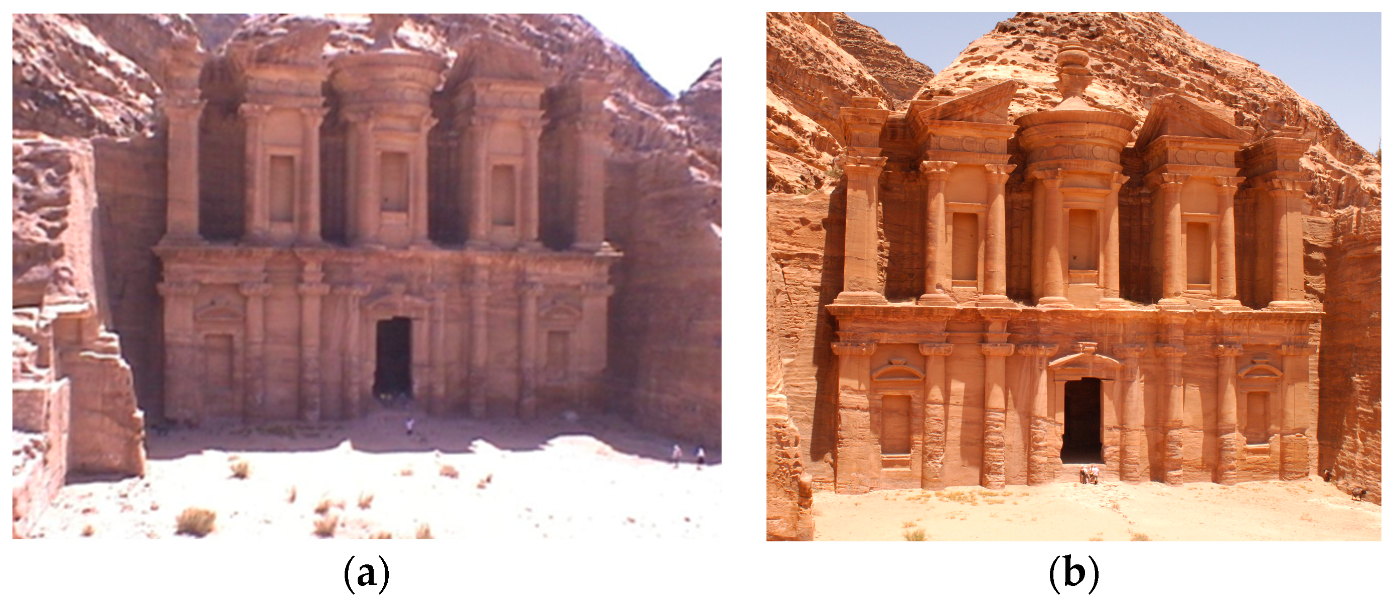
Ad Deir, also known as ‘The Monastery’, is a remarkable archaeological site located in the ancient city of Petra, a UNESCO World Heritage site in Jordan, depicted in Figure 1. This magnificent monument stands as a testament to the ingenuity and architectural brilliance of the Nabateans, an ancient Arab civilization that thrived in the region over two thousand years ago [1]. Ad Deir, depicted in Figure 2, is not only a significant historical landmark but also an important cultural heritage site that draws tourists and researchers from around the world [2]. Moreover, in 2007, Petra, the ancient city that served as the Nabataean empire’s capital between 400 BC and AD 106, gained recognition as one of the ‘New Seven Wonders of the World’. This city showcases a remarkable assortment of temples, tombs, theatres, and other edifices, all meticulously carved into the rosy-hued sandstone cliffs spread across a sprawling 400 square mile area. Recognizing its immense cultural value, UNESCO inscribed Petra into the World Cultural Heritage list in 1985. Unfortunately, many of its monuments have experienced rapid deterioration in recent years [3], In 1998, Petra was listed among the top one hundred most imperilled architectural ensembles by the World Monuments Fund. Furthermore, located in south-western Jordan, Petra faces significant weathering and erosion challenges. The porous nature of the inorganic materials comprising the monuments, combined with uncontrolled environmental conditions, contributes to these problems. The primary force affecting the stone structures is the potential salt damage resulting from weathering [4,5].
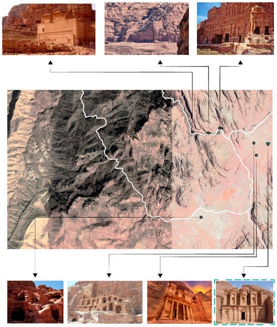
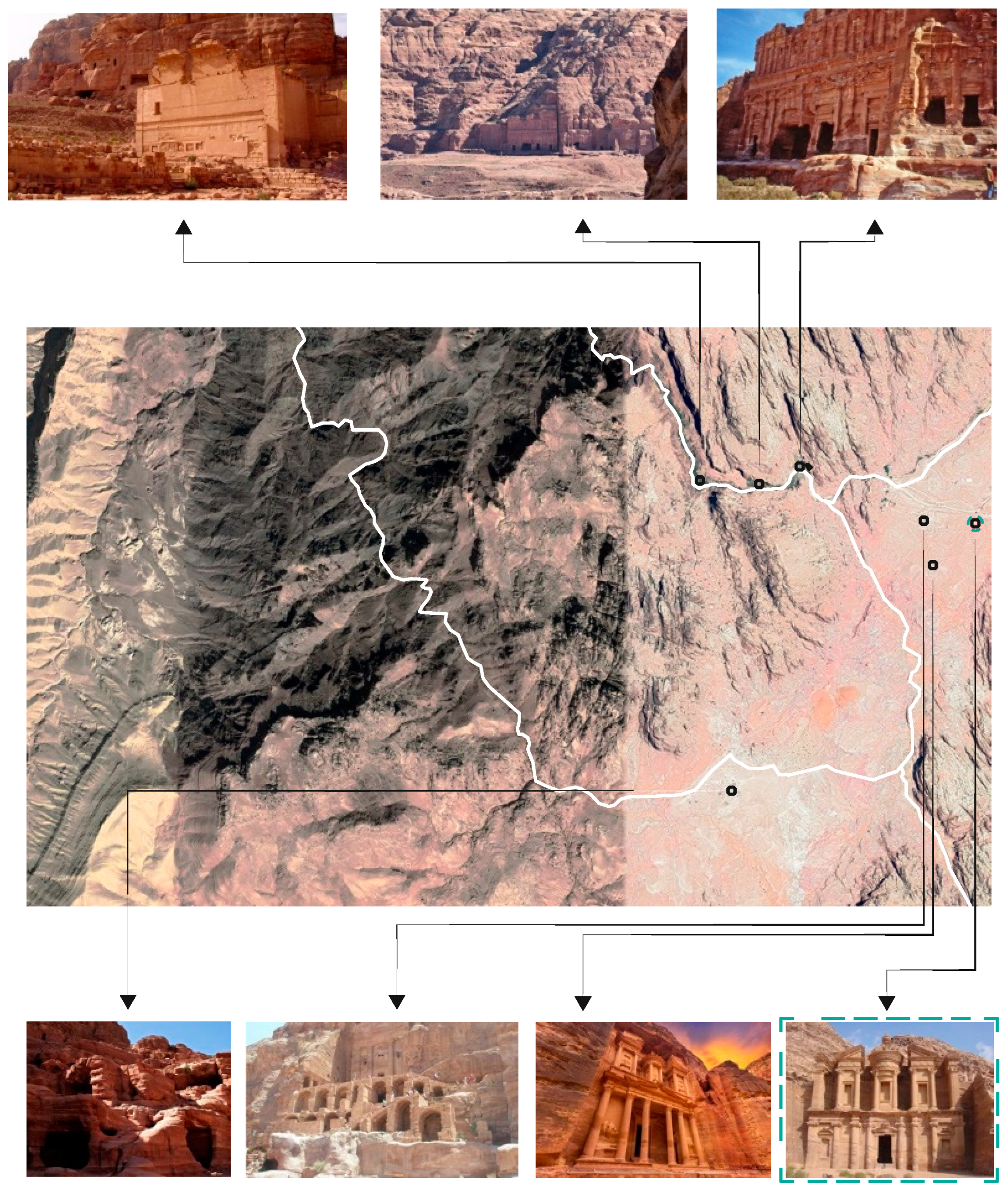
Figure 1.
Locations, roads, and areas surrounding the Tomb.
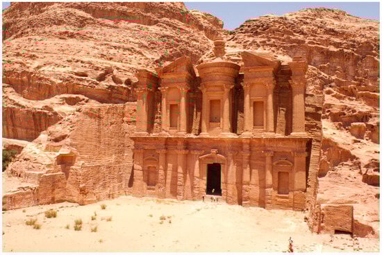
Figure 2.
Al-Deir Tomb, Petra, Jordan.
Until recently, reliable monitoring of weathering had been lacking for most of the monuments in ancient Petra due to the absence of reference archive documents on past weathering damage [6,7]. However, in recent years, a plethora of digital investigation methods has emerged, offering dependable, straightforward, and rapid surveying of large-scale monuments, even those difficult to access. By integrating these modern techniques with laboratory analysis, it becomes possible to quantitatively record, document, and evaluate complete monuments in a comprehensive manner. Furthermore, previous studies on architectural documentation of heritage sites have mainly relied on traditional surveying techniques and manual documentation, which may be time-consuming and prone to human error. Some researchers have investigated the application of 3D laser scanning and photogrammetry techniques. for heritage documentation for examples [1,8], but the integration of BIM technology into these processes remains limited. This paper builds upon these previous works and investigates the potential of heritage BIM for Ad Deir’s architectural documentation.
The research in [1] shows that uncontrolled environmental factors and elevated salt content have emerged as the principal factors contributing to the deterioration of the Al-Deir monument situated within the ancient city of Petra, Jordan. Consequently, there arose a pressing need for a comprehensive investigation and thorough documentation of the monument’s condition. The scientific study adopted a thorough methodology, which involved mapping weathering forms in 2D and creating 3D models using laser scanning and photogrammetry methods. Notably, 3D laser scanning technology played a pivotal role in acquiring precise spatial data pertaining to the monument. The data obtained from these methods facilitate a meticulous assessment of the restoration requirements. In instances of structural damage, the provision of highly detailed, high-resolution 2D images, as well as the meticulous texturing of 3D models of the monument serve to not only depict the stone’s texture but also offer insight into the spatial distribution of weathering phenomena, thereby aiding in the elucidation of the mechanisms and rates of weathering-related issues. Furthermore, this study encompassed laboratory analyses and a correlation study between the salt content and surface weathering damage, both of which constitute the primary mechanisms responsible for the stone’s degradation within the monument. This investigation enables a deeper comprehension of the underlying deterioration processes and causative factors. Additionally, the assessment of salt distribution revealed a distinct correspondence between observable zoning patterns of weathering damage and varying salt concentrations. Moreover, in [8], the multi-image panoramas serve as valuable tools for creating virtual tours and documenting cultural heritage due to their convenience and comprehensiveness. Additionally, they possess metric capabilities that enable the three-dimensional evaluation of objects when at least two panoramas are available [8]. While the procedure is well-established and highly efficient, it is important to note that both the orientation phase and the plotting phase still require manual intervention. The photogrammetric techniques are employed for surveying and representing architecture in three dimensions, with accuracy on par with monoscopic multi-image low-cost approaches. The advantages of employing this method are manifold: it significantly simplifies the photogrammetric process by replacing multiple individual shots with each panorama, allowing for a comprehensive documentation of the object. Moreover, it offers rapid execution and ease of plotting, even for non-expert technicians. However, one notable limitation of this approach lies in the challenging identification of corresponding points, which is relatively straightforward when dealing with sharp points and corners but becomes difficult or even impossible due to the absence of stereoscopy, particularly on rough and uneven surfaces such as rocks or irregular blocks or curved walls commonly encountered in archaeology. To tackle this challenge, the proposed method involves interactively editing a wireframe model derived from the original plot, focusing on specific points deemed appropriate. This editing process is facilitated by projecting oriented panoramas within the 3D environment of 3ds Max®. This projection relies on the known orientation of each panorama, including the projection centre’s three coordinates and three rotation angles. Using computer-aided design (CAD) tools, adjustments can be made to the model’s points and surfaces until they align with the image projection. This approach was applied to the Ad-Deir temple in Petra, Jordan, where certain stone elements, known for their soft texture, had experienced erosion, resulting in irregular shapes. Vector plotting was confined to a few easily identifiable points, from which a wireframe was constructed. This wireframe was then used to generate a surface model, which underwent further refinement and completion by back projecting the three original panoramas used for plotting. Additionally, the image projection was applied as a texture to the surfaces, yielding a satisfactory result.
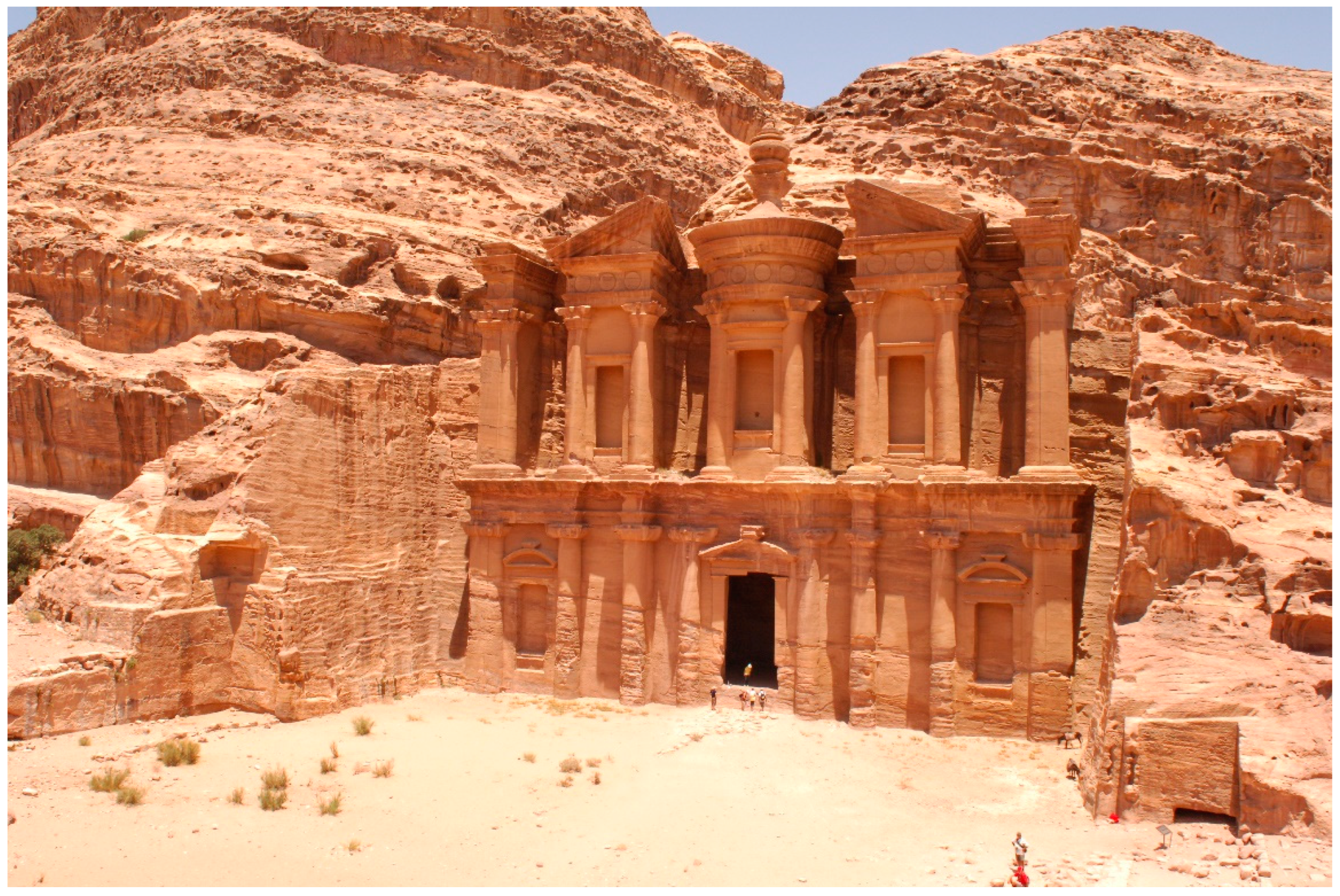
Furthermore, the primary objectives of this research are to develop and demonstrate a methodology for heritage building information modelling (HBIM) that can be broadly applied to the documentation and preservation of cultural heritage architecture [9,10,11,12], to use Ad Deir as a case model, depicted in Figure 3, to illustrate how HBIM can enhance architectural documentation, structural analysis, virtual restoration, and long-term environmental impact modelling, and to facilitate collaboration among multidisciplinary teams, including architects, historians, archaeologists, and engineers, by utilizing HBIM for effective preservation and restoration projects.
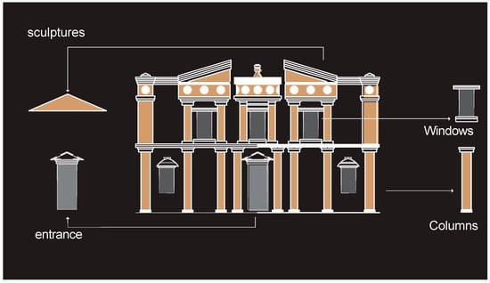
Figure 3.
The main architectural parts of the Ad Deir.
The process leading to these objectives begins with background research and literature review, analysing existing digital documentation methods and previous studies on Ad Deir and other heritage sites. This is followed by data collection and analysis using advanced 3D laser scanning and photogrammetry to gather precise spatial data from Ad Deir, which are then integrated into the HBIM framework to create a detailed and accurate digital model. The absence of parametric library objects in BIM software programs that can be utilized for historical buildings is currently one of the limitations of heritage BIM. When compared to standard BIM, this task is more difficult because historic buildings are composed of irregular and unique structures. Thanks to research in the field of 3D modelling and the primary 3D survey techniques, such as terrestrial laser scanners (TLS) and photogrammetry, it is now possible to generate informative models useful for various types of analysis [13].
The next step involves developing a comprehensive HBIM methodology that incorporates the collected data, ensuring it is adaptable to other heritage sites and addressing challenges such as identifying corresponding points on rough and irregular surfaces through advanced computer vision techniques. The methodology can be then applied and validated by creating a detailed HBIM model of Ad Deir, comparing it with existing documentation, and assessing its effectiveness in structural analysis, virtual restoration, and environmental impact simulation. Finally, collaboration among architects, historians, archaeologists, and engineers is fostered, integrating their expertise into the HBIM process to facilitate informed decision-making and proactive conservation planning [14].
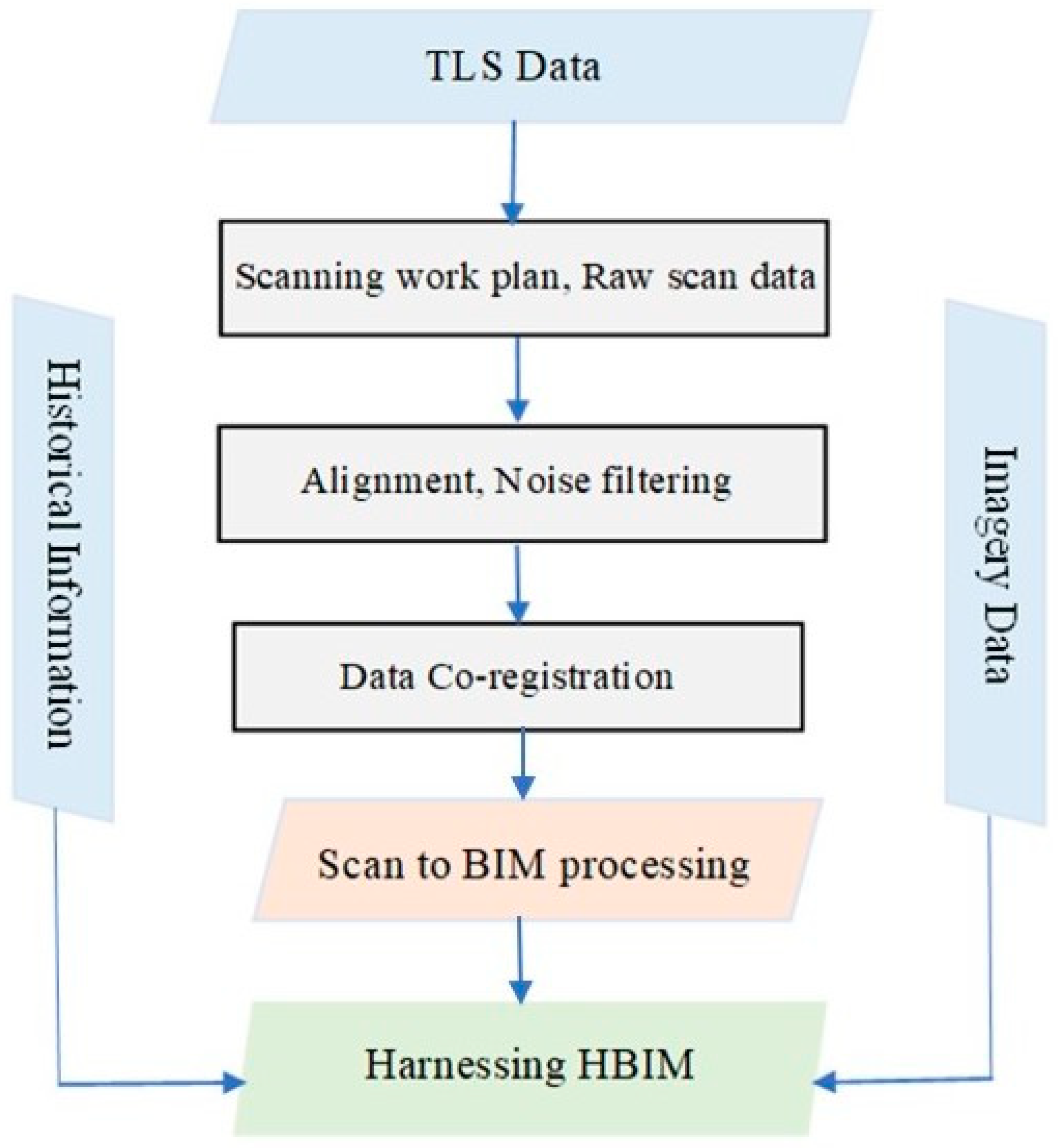
By employing heritage BIM in the documentation of Ad Deir, we can ensure the preservation of this extraordinary architectural marvel for future generations. This comprehensive digital record not only enhances our understanding of the site but also assists in the development of effective conservation strategies. The method and the work flow of HBIM can be shown in Figure 4. Moreover, the digital models created through Heritage BIM can be shared with the public, allowing visitors to experience the site virtually and appreciate its historical and cultural significance even if they cannot visit it in person [15]. Furthermore, the integration of Heritage BIM in the architectural documentation of Ad Deir and other heritage sites revolutionizes the preservation and study of our architectural past. By harnessing advanced technologies, we can create immersive digital representations that capture the essence of these structures, providing invaluable resources for research, conservation, and public engagement.
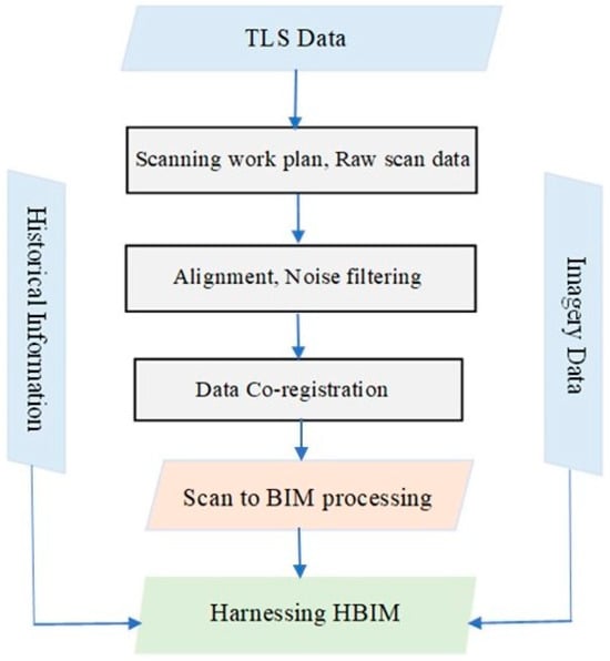
Figure 4.
Harnessing HBIM workflow.
Furthermore, collaboration among conservators, architects, engineers, historians, and other stakeholders is essential to ensure that the enriched BIM model is useful and accurate. Facilitating collaboration among these diverse stakeholders involves several key aspects. For example, effective communication channels are established to facilitate dialogue among different disciplines. Also, information from various sources, such as archival records, historical documents, surveys, and scientific analysis, is integrated into the heritage BIM model. This comprehensive dataset provides a holistic view of the heritage site and its condition. Moreover, the collaboration is an iterative process wherein feedback from different stakeholders is incorporated into the BIM model. This ensures that the model remains accurate and up to date throughout the conservation process [16].
Likewise, the utilization of the information in the heritage BIM model by different disciplines involves various applications. This can be via utilizing BIM to assess the condition of heritage structures, plan conservation interventions, and monitor erosion over time and incorporate heritage data into architectural designs, renovations, and adaptive reuse projects while ensuring compliance with conservation principles as well as analyze structural integrity, perform risk assessments, and develop mitigation strategies based on the information provided by the BIM model and access historical documentation and contextual information embedded in the BIM model to conduct research and interpret the site’s significance. Moreover, we can reap benefits from the collaborative efforts by gaining access to accurate and comprehensive information for decision-making, policy development, and public engagement initiatives [17].
The Aim
The aim of this paper is to develop and demonstrate a methodology for heritage building information modelling (HBIM) that can be broadly applied to the documentation and preservation of cultural heritage architecture. Using Ad Deir, a significant historical structure in Petra designated as a UNESCO World Heritage Site, as a case model, this research illustrates how HBIM can enhance architectural documentation, structural analysis, virtual restoration, and long-term environmental impact modelling. This methodology facilitates collaboration among multidisciplinary teams, including architects, historians, archaeologists, and engineers, for effective preservation and restoration projects across various cultural heritage sites.
2. Literature Review
The architectural preservation and documentation of cultural heritage sites stand out as paramount endeavours in safeguarding the legacy of our past. Within this realm, the integration of innovative technologies has significantly revolutionized the methodologies and precision employed in capturing and conserving these invaluable treasures. This literature review delves into the convergence of two pivotal realms—3D reality capture approaches and building information modelling (BIM)—within the domain of heritage documentation. Focused on the context of Petra’s iconic Ad Deir, this paper scrutinizes the efficacy of harnessing heritage BIM as a means to enhance the architectural documentation process. Through a comprehensive exploration of these domains, this review aims to elucidate the synergistic potential, challenges, and transformative impact when these technologies converge in the preservation and understanding of cultural heritage.
2.1. 3D Reality Capture Approaches in Heritage
This 3D reality capture technique in heritage preservation, utilizing 3D laser scanning and data processing, represents a revolutionary approach to documenting and conserving our cultural legacy. Three-dimensional laser scanning, a non-invasive and high-precision technology, allows for the rapid and accurate acquisition of detailed 3D point cloud data from heritage sites and artifacts [18]. These data serve as a foundation for the creation of comprehensive and lifelike 3D models, preserving the intricate details of historical structures and objects. Advanced data processing techniques, including registration, filtering, and mesh generation, play a pivotal role in refining the raw point cloud data into precise and visually appealing reconstructions [19]. By harnessing the benefits of 3D reality capture, heritage preservation efforts can maintain the integrity of sites, minimize physical intrusion, enhance documentation accuracy, and facilitate research and virtual visualization, ensuring our cultural heritage is safeguarded for future generations. Although some challenges exist, such as equipment cost and data volume, continuous technological advancements and research will undoubtedly propel the field of 3D reality capture further, revolutionizing the way we approach heritage conservation and research [20].
The 3D reality capture approaches can be categorized into two main methods. The first method is 3D laser scanning, which entails the utilization of a 3D laser scanner to capture intricate 3D data of the building’s surface geometry, including its roof, walls, windows, and other features. This process involves emitting a laser beam from the scanner, which reflects off the surfaces of the building. The scanner’s sensor then records the reflection and measures the distance from the scanner to each point on the building’s surface [14]. Moreover, terrestrial laser scanning is an automated measurement method used to determine the 3D surface coordinates of a selected object. The output data from the laser scan is displayed as a point cloud, with each point comprising x, y, and z coordinates indicating the scanned surface. Currently, there are several laser scanning systems offered on the engineering market, each employing one of three different scanner methods: time-of-flight, triangulation, and phase comparison [21]. These methods can be advantageous for metric heritage studies. The variation between these scanner systems lies in how they compute 3D coordinate measurements. For instance, in the case of the triangulation type, the scanner employs laser beam points on the object’s surface, which are captured using one or more cameras [22]. The second approach is photogrammetry, which is a powerful 3D reality capture approach that has found numerous applications in the heritage and cultural preservation sector. It involves the use of photographs or images to create accurate and realistic 3D models of real-world objects or environments. In the context of heritage, photogrammetry is particularly valuable for documenting and preserving historical sites, artifacts, and buildings [20]. Furthermore, photogrammetry is used to capture detailed 3D models of archaeological sites, allowing researchers to preserve the site’s condition at a specific point in time. These models can be used for analysis, virtual reconstructions, and dissemination of information to the public. Moreover, it can be noted that historic buildings and structures are at risk of deterioration over time. Photogrammetry can be used to create accurate 3D models of these buildings, serving as a record of their original state, and supporting restoration efforts [23]. Additionally, photogrammetry-generated 3D models allow users to experience heritage sites or artifacts in immersive VR or AR environments. This enhances educational opportunities and visitor engagement [24]. It is important to note that photogrammetry does have certain requirements for optimal results. High-quality cameras, proper lighting, and accurate camera positioning are crucial for obtaining accurate and detailed 3D models. Additionally, post-processing software is used to align and stitch the images together, generating the final 3D representation. The ultimate results can be utilized to generate detailed engineering drawings, maps, and other visual representations of the building’s structure, encompassing its geometry, dimensions, and surface characteristics [14].
2.2. Building Information Modelling (BIM) in Cultural Heritage
HBIM, abbreviated from ‘heritage building information modelling’, is an advanced process that entails constructing a digital portrayal of a heritage building or structure through the utilization of building information modelling (BIM) technology and tools. This digital model contains comprehensive information about the building’s architecture, construction, materials, and historical significance. Additionally, it includes data about the current condition of the structure and its maintenance requirements. The application of heritage BIM extends to supporting preservation, restoration efforts, and ongoing management of these valuable heritage buildings [25]. Heritage BIM relies on an interactive engineering 3D model, typically based on a combination of terrestrial laser scanning data (TLS), architectural photogrammetry, and cultural heritage data [26]. Through this approach, heritage BIM can automatically generate technical drawings and orthographic views, sections, and 3D models of the heritage buildings. In the context of the heritage conservation and preservation sectors, heritage BIM proves to be immensely beneficial. Firstly, it enhances the understanding of heritage site and their historical context. This technology enables researchers and experts to gain insights into the building’s materials, construction techniques, structural aspects, and even any existing pathologies [14]. Heritage BIM facilitates a thorough analysis of proposed renovations and changes before final decisions are made as well as ensuring that any interventions are carefully planned to preserve the building’s authenticity and historical significance. It also assists with ongoing maintenance, as it provides valuable information for budgeting repairs and maintenance activities. Additionally, by using free viewer applications, heritage BIM allows for a broader public engagement, as models can be accessed and explored remotely from various locations [25]. Introducing cultural heritage information about the Petra heritage site further enriches the heritage BIM process [25,26]. This enables the development of detailed insights into the building’s construction methods and material compositions. By employing various program platform management techniques, prototypes of libraries with parametric objects can be seamlessly integrated into the photogrammetry and point cloud data, enhancing the overall heritage BIM process [14]. Heritage building information modelling (HBIM) represents a cutting-edge approach to preserving and managing heritage buildings. By combining advanced technologies and cultural heritage data, HBIM not only helps to safeguard these architectural treasures but also facilitates informed decision-making, efficient maintenance, and wider public engagement with our rich heritage.
Indeed, BIM plays a key role as a BIM as a game-changer in heritage preservation. For example, BIM offers several advantages that make it a powerful tool for heritage preservation [27,28,29,30], which can be described as ‘comprehensive documentation’. BIM enables the creation of detailed and accurate digital representations of heritage structures, capturing not only their physical dimensions but also their historical context, materials, and construction techniques. This comprehensive documentation is essential for understanding, preserving, and managing cultural heritage sites. The use of BIM facilitates precise measurements, analysis, and simulations, allowing researchers to assess the structural integrity of heritage buildings, analyze deterioration, and develop informed conservation strategies. BIM models provide valuable insights into the condition of heritage structures, helping to prioritize conservation efforts and ensure their long-term preservation.
Moreover, BIM fosters collaboration among multidisciplinary teams involved in heritage preservation, including architects, historians, archaeologists, conservators, and engineers. By providing a common platform for data sharing and communication, BIM facilitates the integration of diverse expertise and perspectives, leading to more effective conservation outcomes [31].
Furthermore, today huge quantities of software support BIM. For example, Autodesk Revit is a widely used BIM software in the building industry [32]; other tools like 3DS MAX also offer powerful capabilities for creating 3D models and visualizations [33,34]. In the context of heritage BIM, the choice between Revit and 3DS MAX can impact the workflow, capabilities, and outcomes of the study. In fact, Revit is specifically designed for building design and construction, offering advanced BIM functionalities such as parametric modelling, data interoperability, and collaboration tools. Its seamless integration with other Autodesk software and BIM standards makes it well-suited for heritage preservation projects where BIM processes are employed. On the other hand, 3DS MAX, while capable of producing high-quality visualizations, may require additional steps for data conversion and integration with BIM workflows [34]. Moreover, Revit’s parametric modelling capabilities enable users to create intelligent 3D models with detailed information about building components and relationships. This facilitates data enrichment and analysis, essential for heritage documentation and conservation [35]. In contrast, 3DS MAX is primarily focused on visualization and may lack the parametric modelling features required for generating intelligent BIM models. Additionally, Revit’s native file format and support for industry foundation classes (IFC) ensure interoperability with other BIM software and data exchange standards, facilitating collaboration among stakeholders [36]. While 3DS MAX offers compatibility with various file formats, interoperability with BIM platforms may require additional effort and may not support the seamless exchange of intelligent BIM data.
2.3. Enhancing the User Interaction Experiences in Heritage Site
One of the most interactive experiences for heritage sites can be via virtual tours. Three-dimensional models created from laser scanning and photogrammetry can be integrated into virtual tour platforms, allowing users to explore Ad Deir in a highly immersive manner. Visitors can navigate through the site from the comfort of their homes, experiencing the monument from different perspectives and angles [15]. Also, heritage BIM data can enhance virtual tours by providing interactive elements within the 3D model. Users can click on specific architectural features or historical artifacts to access additional information, such as historical context, construction techniques, or conservation efforts [37]. This interactive approach fosters engagement and deepens users’ understanding of the site’s significance. Moreover, virtual tours can incorporate guided narratives or audiovisual presentations, offering curated experiences led by experts or historians [38]. These narratives can provide insights into the historical context of Ad Deir, highlighting key architectural features, cultural significance, and stories behind the monument’s creation.
Three-dimensional models and heritage BIM data can serve as valuable educational resources for students and educators [39]. Schools and universities can integrate these digital assets into their curricula, allowing students to engage with cultural heritage in a dynamic and interactive manner [40]. Educational modules can cover topics such as archaeology, architecture, history, and conservation, providing a holistic understanding of Ad Deir and its place in history. Moreover, the educational applications can enable students to interact with 3D models of Ad Deir, encouraging hands-on exploration and experimentation. Virtual labs or workshops can simulate archaeological excavations, architectural analysis, and conservation practices, empowering students to become active participants in heritage preservation efforts. Furthermore, gamified experiences can make learning about cultural heritage more engaging and enjoyable. Educational applications can incorporate game elements, challenges, and quizzes based on Ad Deir’s history and architecture. By gamifying the learning process, these applications can capture the attention of younger audiences and instil a sense of curiosity and appreciation for cultural heritage [41].
2.4. Maintaining the Heritage BIM Database: Strategies and Frameworks
To ensure the regular update and maintenance of the heritage BIM database for Ad Deir in Petra, Jordan, detailed strategies and technical frameworks are essential. Firstly, this can be via implement a version control system to track changes made to the heritage BIM database over time. This system should record who made the changes, when they were made, and what specific modifications were implemented. Moreover, through utilising version control software such as Git v. 2.45.1. or SVN v. 1.14.7 (Subversion) to manage revisions effectively. These tools allow for branching, merging, and tagging of database versions, facilitating collaboration among team members, and ensuring data integrity while establishing clear protocols and workflows for updating the database, incorporating guidelines for reviewing, and approving changes before implementation. This approach ensures consistency and accuracy in the data [17].
Secondly, these tools allow for the selection of a reliable storage solution for the heritage BIM database, ensuring scalability, security, and redundancy. Cloud-based storage services like Amazon S3, Microsoft Azure, or Google Cloud Storage offer scalable and secure options for storing large datasets as well as the implementation of regular backup procedures to prevent data loss in case of hardware failure, system errors, or security breaches. Backups should be performed frequently and stored in geographically diverse locations to mitigate the risk of data loss. Sensitive encrypted data should be stored in the database to protect it from unauthorized access or data breaches. Strong encryption algorithms and secure access controls should be used to safeguard the confidentiality and integrity of the data [42].
Thirdly, access control policies can regulate who can view, edit, and delete data in the heritage BIM database. Role-based access control (RBAC) can be used to assign permissions based on users’ roles and responsibilities within the project team. Authentication mechanisms, such as username/password authentication or multi-factor authentication (MFA), can be implemented to verify the identity of users accessing the database. This helps prevent unauthorized access and unauthorized changes to the data. User activity should be monitored and database access logs audited to detect any suspicious or unauthorized behaviour. Access control settings and user permissions should be regularly reviewed to ensure compliance with security policies and regulatory requirements [43].
Finally, a change management process should be established to document and track proposed changes to the heritage BIM database. This process should include steps for submitting change requests, assessing their impact, obtaining approvals, and implementing the changes. A change log or change register should be maintained to record details of all approved changes, including the rationale for the change, the affected database components, and the individuals responsible for implementing the change. Regular reviews and audits of the database should be performed to identify potential issues, discrepancies, or data inconsistencies. Any identified issues should be addressed promptly and corrective actions taken to maintain data quality and reliability should be documented [44].
3. Scan for Heritage BIM Processing for Ad Deir Tomb
The study employs a heritage BIM method for the Ad Deir Tomb in Petra, which includes data acquisition via 3D laser scanning followed by BIM processing of architectural elements using Revit Autodesk software v.23.0. The rich and complex architectural features of ad Deir necessitated multi-sensor recording to trace and accurately model the features at detailed levels. The heritage BIM model is then enhanced with historical context based on the extensive research and archaeological evidence [45].
3.1. Data Collection and Preprocessing
Data collection and pre-processing involved the utilization of the Mensi GS100 Laser Scanner to acquire the surface point cloud data for our investigation. This advanced scanner boasts a remarkable maximum capture range of 100 m, a wide 360-degree by 60-degree field of view, and an impressive precision of 6 millimetres. Concurrently with data collection, the scanner’s attached camera captured calibrated video snapshots at a resolution of 768 × 576 pixels, seamlessly integrating them with the corresponding point measurements [46]. Given the scale and complexity of the structure, a single laser scan proved insufficient to cover the entirety of Al-Deir tomb. Consequently, five distinct viewpoint scans were meticulously conducted to address occlusions and obstructions, resulting in the acquisition of nearly 6 million points with a ground sampling distance (GSD) of 3 cm.
The 3D terrestrial laser scanning process involved the emission of laser pulses from the scanner, which bounce off surfaces and return to the scanner, allowing for precise measurements of distance and elevation. This methodology ensures not only geometric accuracy but also captures detailed texture and color information, providing a comprehensive representation of the scanned object. In the case of Al-Deir tomb, the scanner’s ability to capture texture alongside geometric data enabled the creation of highly detailed models that accurately depict the monument’s visual appearance.
Moreover, the versatility of TLS allows for the scanning of large-scale structures with intricate details. However, due to the limitations of line-of-sight and potential occlusions, multiple scans from different viewpoints are often necessary to comprehensively capture the entire structure. This meticulous approach ensures that even obscured areas are accounted for, resulting in a comprehensive and accurate representation of the architectural features.
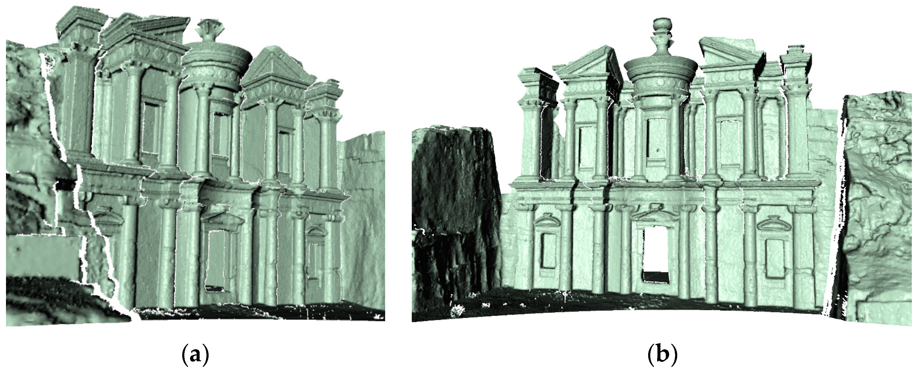
Following data acquisition, post-processing steps are undertaken to refine and enhance the collected point cloud data. This includes noise reduction to eliminate any extraneous data points and alignment of multiple scans to create a seamless, unified model. Through the integration of advanced software tools like Cloud Compare v. 2.11.3, the individual scans are aligned into a single coordinate system, ensuring spatial coherence and accuracy across the dataset. Figure 5 depicts Ad Deir’s completed model as a coloured point cloud. Figure 6 depicts the monument’s mesh model.
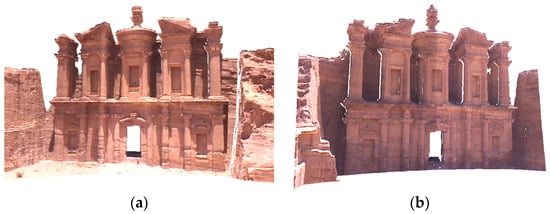
Figure 5.
The 3D point cloud data for Ad Deir tomb. (a) shows the right side of the tomb; (b) shows the left side of the tomb.
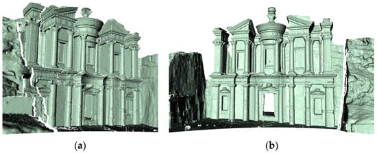
Figure 6.
The 3D mesh model of the monument. (a) shows the left side of the tomb; (b) shows the right side of the tomb.
3.2. HBIM Implantation Using TLS and Imagery Data
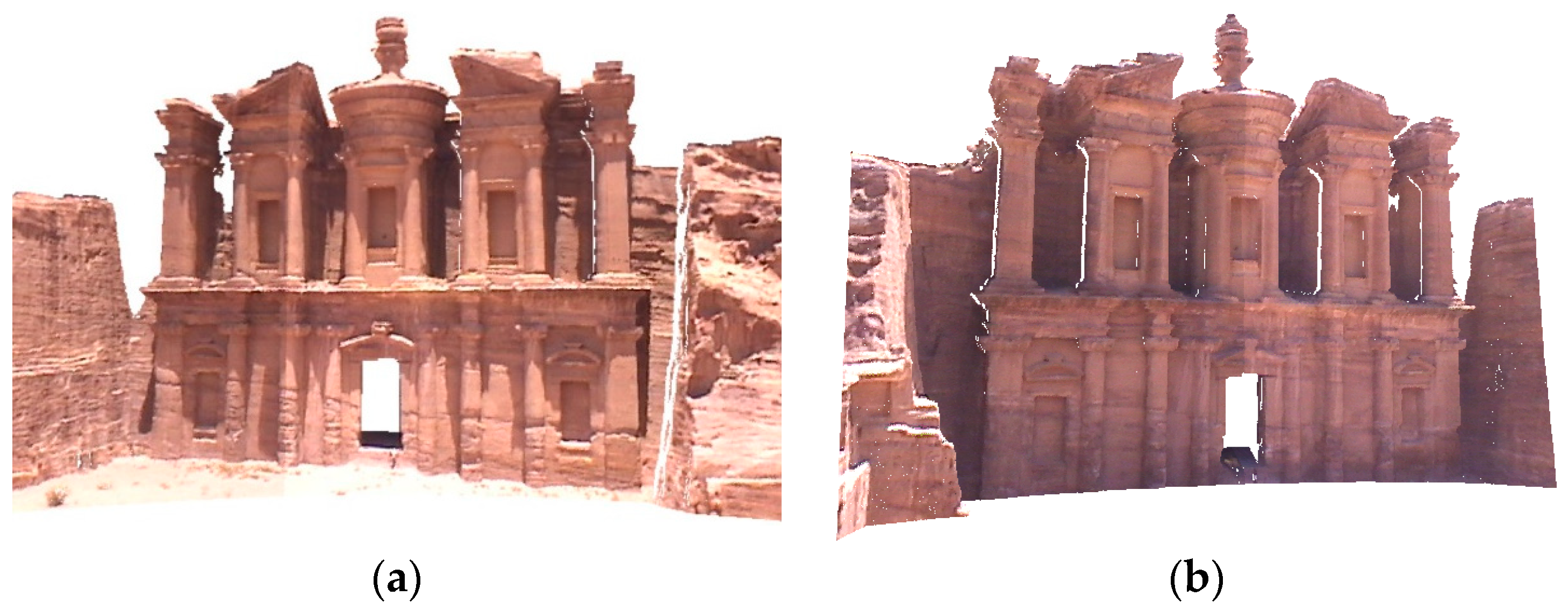
HBIM implementation using TLS and imagery data presents both advantages and challenges. While the laser scanner captures surface geometry directly, resulting in a high-density and consistent 3D point cloud representation, it encounters limitations in capturing cloud colors effectively. Particularly outdoors, the positioning of the scanner relative to the attached camera may be suboptimal, leading to variations in lighting conditions between scans and resulting images, as illustrated in Figure 7a. These inconsistencies can compromise the accuracy and reliability of the scan-to-BIM technique, especially in representing surface features of complex structures like the Ad Deir tomb. However, strategically captured images, taken at ideal positions and moments, offer a more precise representation of color and facade features, as demonstrated in Figure 7b. To address these challenges in our methodology, both datasets were imported into the BIM platform. The TLS-registered point cloud serves as the basis for modeling uniform and regular components such as walls and columns. Meanwhile, the irregular Nabatean elements are traced and modeled using independent imagery sources, ensuring a comprehensive representation of the monument’s intricate features, as depicted in Figure 8. This hybrid approach leverages the strengths of both TLS and imagery data to overcome the limitations inherent in each, ultimately enhancing the accuracy and fidelity of the HBIM model for the Ad Deir tomb. In the HBIM process, additional steps are taken to integrate historical context and archaeological evidence. This involves extensive research to understand the cultural significance of the structure and its components. Historical data, including photographs, drawings, and written records, are incorporated into the model to enrich its informational value. By contextualizing the architectural elements within their historical and cultural framework, the HBIM model becomes more than just a digital representation; it becomes a tool for preserving and interpreting heritage assets for future generations.
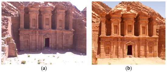
Figure 7.
(a) Imagery from laser scanner. (b) One of the independent images used for accurate BIM tracing.
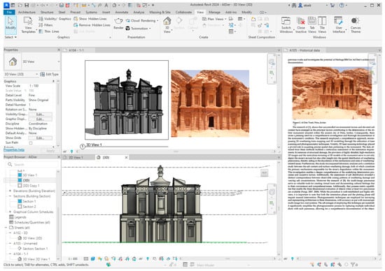
Figure 8.
Import scanning data and imagery for BIM tracing and modeling of Ad Deir architectural elements.
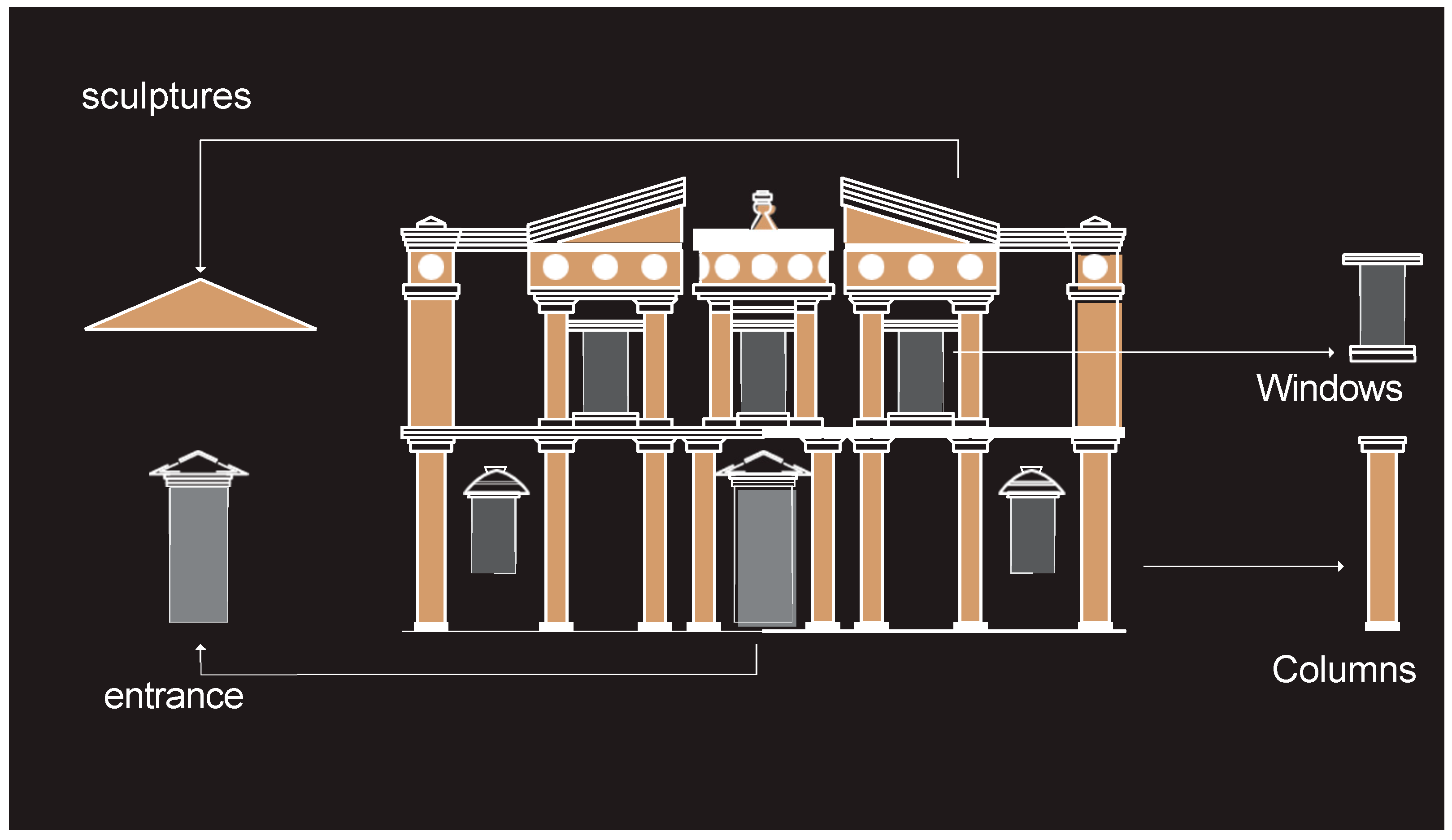
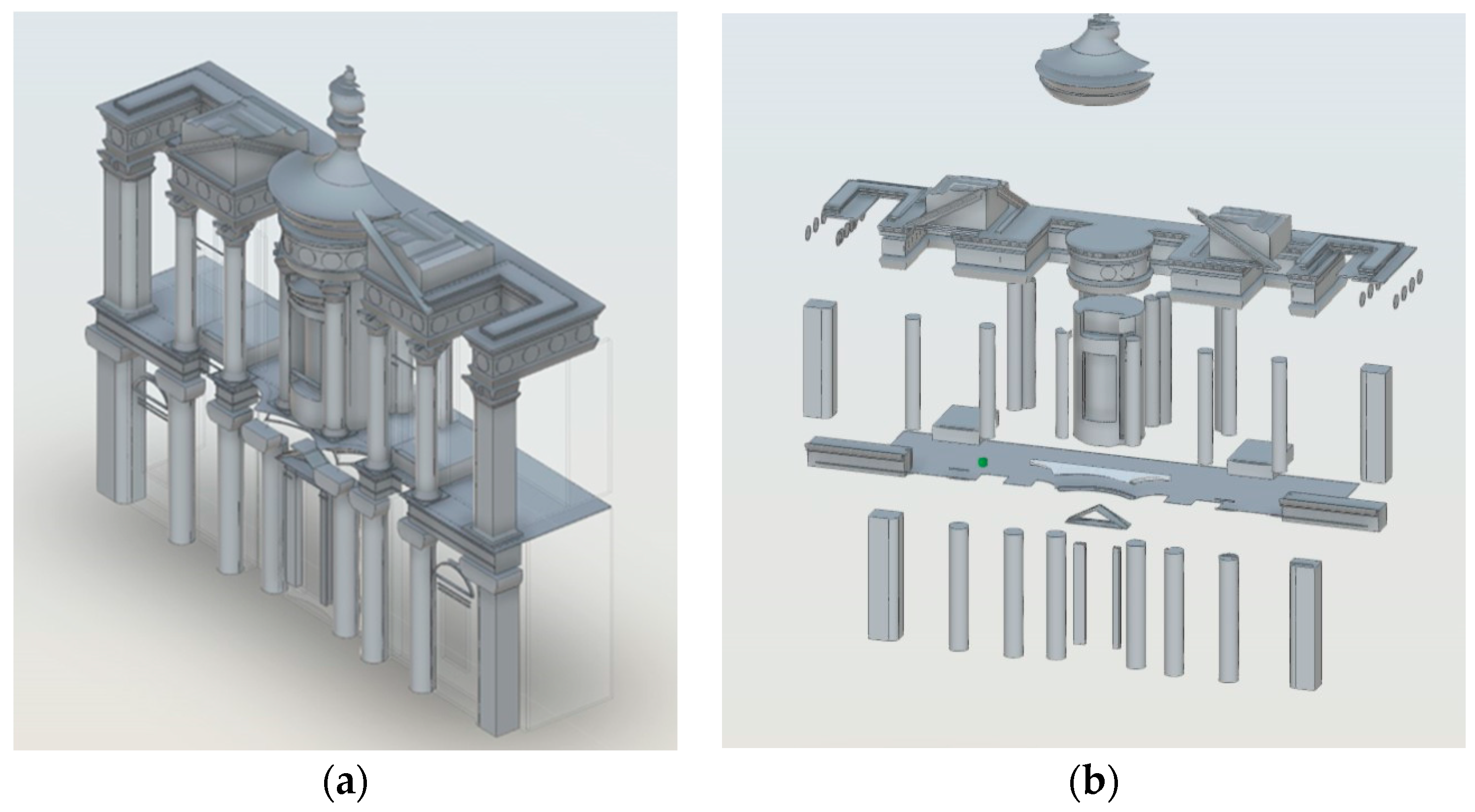
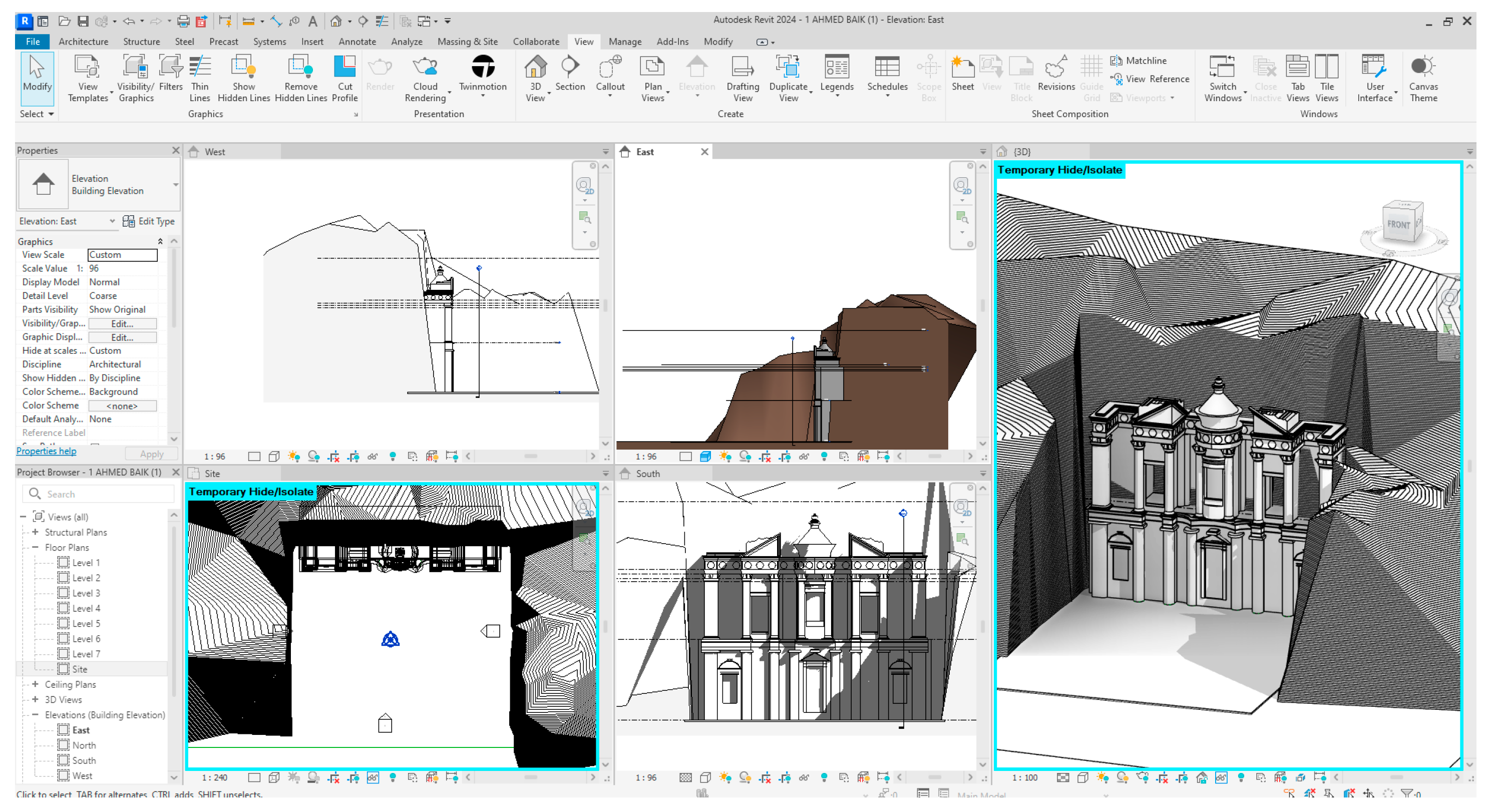
When moved into Autodesk Revit, the HBIM model of the Ad Deir tomb is further refined and detailed. Utilizing Revit’s robust capabilities, a family library specific to the architectural elements of the tomb is created, as depicted in Figure 9a. This library includes a wide range of parametric families tailored to accurately represent the unique features of the structure, such as intricate carvings, ornamental motifs, and structural components, depicted in Figure 9b. Each family is meticulously crafted to ensure accuracy and consistency throughout the model. Within Revit, the TLS-registered point cloud data serves as a reference for modeling the overall structure, providing precise dimensions and spatial relationships. The Revit families from the created library are then strategically placed and aligned within the model, adhering to the layout and composition observed in the point cloud data. This iterative process involves careful adjustment and validation to ensure that the HBIM model faithfully reflects the architectural intricacies of the Ad Deir tomb, as depicted in Figure 10. Moreover, Revit’s parametric modeling capabilities enable dynamic adjustments to the HBIM model, facilitating scenario analysis and adaptive reuse planning. By creating parametric families with adjustable parameters, stakeholders can explore different design alternatives and preservation strategies within the context of the historical structure. This interactive approach fosters collaboration and informed decision-making, ensuring that the HBIM model not only preserves the past but also informs future interventions and conservation efforts.
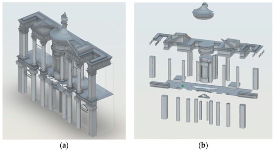
Figure 9.
Creating family blocks in BIM software. (a) inserting the family into the model, and (b) exporting the family out of the model.
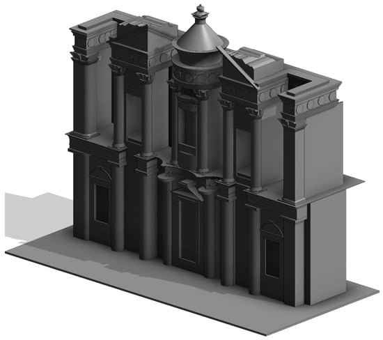
Figure 10.
The 3D HBIM of Al-Deir tomb.
The novelty of this research lies In Its comprehensive approach to heritage preservation and documentation, combining advanced technologies such as TLS and BIM with traditional archaeological methods. By integrating multiple datasets and leveraging cutting-edge software tools, the study achieves a level of detail and accuracy previously unattainable. This interdisciplinary approach not only enhances our understanding of the Ad Deir tomb but also establishes a methodology that can be applied to other heritage sites worldwide, contributing to the global efforts in cultural heritage conservation and management.
4. Results and Discussion
The application of heritage BIM to Ad Deir has yielded promising results. The 3D BIM model provides a highly accurate as well as detailed representation of the monument, enabling researchers and conservationists to explore various aspects of the structure remotely. The model facilitates the identification of deterioration and potential conservation strategies, supporting the preservation efforts of this heritage site. Additionally, the interactive BIM model allows visitors to experience Ad Deir in virtual reality, promoting public engagement and educational opportunities.
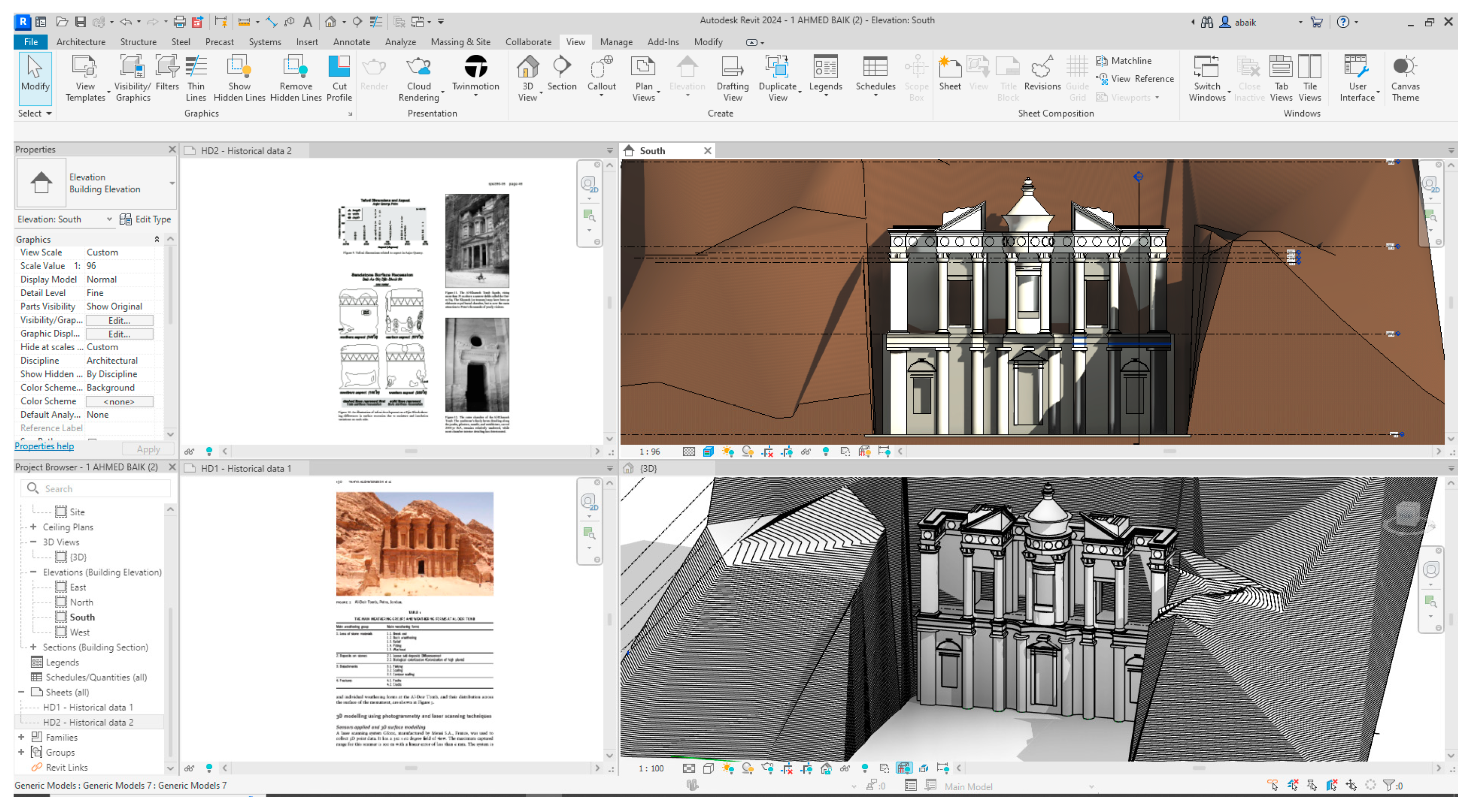
The application of heritage BIM for the enhanced architectural documentation of Ad Deir Tomb in Petra has yielded promising results and can directly provide the engineering drawings and historical information. This can be shown in Figure 11 and Figure 12. Through the integration of various data sources and technologies, a comprehensive 3D digital documentation and heritage BIM model of the monument were successfully created. This section discusses the key findings and implications of this endeavour. The 3D digital documentation of Ad Deir Tomb incorporated data from diverse sources, including laser scanning, photogrammetry, and architectural surveys. These data sources provided a holistic representation of the monument, capturing both geometric and textural details. The integration of data was seamless, resulting in a highly accurate and detailed 3D model. This approach aligns with the principles of heritage BIM, which emphasize the importance of multi-source data integration for a comprehensive understanding of heritage structures [35]. Heritage BIM offers an immersive and visually rich representation of the Ad Deir Tomb. Researchers, conservationists, and the public can explore the monument virtually, gaining insights into its architectural intricacies. The model facilitates the interpretation of historical and architectural features, supporting educational and research initiatives. This aligns with the goals of cultural heritage preservation, as it enhances accessibility and engagement with heritage sites [47]. One of the significant advantages of heritage BIM is its ability to assess the structural condition of the Ad Deir Tomb. The 3D model enables a detailed analysis of deterioration, damage, and deformation. By comparing the current state of the monument to historical records, researchers can identify areas of concern and prioritize conservation efforts [48]. This analytical capability is invaluable for long-term preservation strategies.
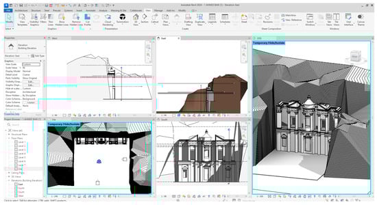
Figure 11.
Providing engineering information via Revit.
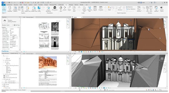
Figure 12.
The integration of Historical data within HBIM model.
On the other hand, during the project, several numbers of technical limitations and challenges were associated with the ‘scan to heritage BIM’ methodology. Several factors need consideration. First are the data collection challenges. One significant hurdle in utilizing 3D laser scanning and photogrammetry for data acquisition is the complexity of capturing data from rough and irregular surfaces. The Ad Deir Tomb, being an ancient structure, likely poses challenges in obtaining accurate data due to its diverse surface characteristics. Manual intervention may be necessary to identify corresponding points on such surfaces, increasing the time and effort required for data collection. Second are the computational demands. Processing large-scale data acquired through 3D laser scanning can be computationally intensive. The sheer volume of data, especially when dealing with millions of point clouds, necessitates powerful computing resources and efficient algorithms for data processing and registration. This can lead to increased processing time and resource requirements, potentially limiting the scalability of the methodology, especially in resource-constrained environments. Finally are the software limitations. While BIM platforms offer capabilities for data integration and modeling, not all platforms may be well suited for modeling heritage projects with irregular and unique elements [16]. Existing family libraries within BIM software may not adequately represent the architectural nuances of heritage structures like theAd Deir Tomb, necessitating the creation of custom families. This process adds complexity and may require specialized expertise in BIM modeling.
Moreover, to address these technical challenges, several strategies can be employed.
First are advanced computer vision techniques. Exploring advanced computer vision techniques, such as feature extraction algorithms and surface reconstruction methods, can improve the accuracy and efficiency of data acquisition and processing. These techniques can help automate the identification of corresponding points on irregular surfaces, reducing the need for manual intervention and streamlining the data collection process. Second is high-performance computing. Investing in high-performance computing infrastructure can accelerate data processing and registration tasks, reducing the computational burden associated with large-scale data sets. Parallel processing and distributed computing architectures can be leveraged to efficiently handle the processing demands of 3D laser scanning data. Finally are custom BIM libraries. Developing custom BIM libraries tailored to heritage projects can address the limitations of existing family libraries within BIM software [26]. These custom libraries can include predefined templates and components specifically designed to represent the unique architectural elements found in heritage structures like Ad Deir Tomb. Collaborative efforts among heritage practitioners, BIM experts, and software developers can facilitate the creation of comprehensive BIM libraries optimized for heritage conservation projects.
Furthermore, heritage BIM serves as a foundational tool for documentation as well as the conservation planning. It facilitates the identification of areas with high salt content, a common issue in Petra’s sandstone monuments [49]. Understanding the spatial distribution of salts within the monument is crucial for devising targeted conservation strategies. Additionally, the model aids in identifying vulnerable structural elements, such as eroded surfaces and unstable sections, which can inform preservation decisions [10].
5. Conclusions
This scientific paper demonstrates the effectiveness of heritage building information modelling (HBIM) in enhancing the architectural documentation and preservation of cultural heritage sites. Using Ad Deir in Petra, Jordan as a case model, we have illustrated how the integration of BIM technology with heritage documentation practices can yield significant advantages, such as data accuracy, comprehensive analysis, and immersive visualization. These benefits underscore the potential of HBIM methodologies to be broadly applied across various culturally significant sites worldwide. The research contributes to the growing body of knowledge on heritage BIM methodologies, showcasing its ability to create highly accurate and detailed 3D digital documentation and HBIM models. These models serve as foundational tools for preservation and conservation planning, enabling the identification of areas of deterioration, vulnerability, and salt content. By facilitating informed decision-making processes and supporting ongoing maintenance and management efforts, HBIM empowers conservationists, architects, historians, and other stakeholders to safeguard and promote the architectural heritage of culturally significant sites like Ad Deir.
While the study has yielded promising results, such as the creation of a detailed HBIM model for Ad Deir, it is important to acknowledge the challenges, including the manual identification of corresponding points on rough and irregular surfaces. Future research could explore advanced computer vision techniques to address these challenges and further refine the HBIM process. Additionally, ongoing monitoring and periodic updates of HBIM models are essential to track changes in the condition of heritage structures over time. This approach facilitates adaptive conservation strategies and ensures long-term preservation. The integration of HBIM with 3D digital documentation techniques has provided a robust framework for enhanced architectural documentation, aiding in conservation planning and promoting public engagement with cultural heritage. The theoretical implications of this study extend beyond architectural documentation to broader discussions on heritage preservation and digital heritage. By introducing the concept of the ‘scan to heritage BIM’ methodology, this research contributes to the evolving discourse on innovative approaches to heritage conservation. The integration of diverse data sources into a cohesive HBIM model enriches our understanding of heritage structures and fosters interdisciplinary research collaboration. From a practical standpoint, the findings of this study have significant implications for heritage practitioners, conservationists, and policymakers. The creation of a highly accurate and detailed HBIM model of Ad Deir enables proactive conservation planning and informed decision-making processes. Conservationists can leverage the model to prioritize conservation efforts and ensure the long-term sustainability of the monument.
Looking ahead, future research could leverage advanced technologies such as AI, deep learning, and machine learning to further enhance HBIM model of Ad Deir. By training algorithms on large datasets of historical and structural information, AI models could automate the process of data integration, feature extraction, and anomaly detection within the HBIM framework. Deep learning techniques could be employed to analyse complex patterns in the structural deterioration of Ad Deir, providing valuable insights into the underlying causes and informing targeted conservation strategies. Moreover, the integration of AI, deep learning, and machine learning into HBIM model of Ad Deir holds tremendous potential to revolutionize heritage conservation practices. By leveraging these advanced technologies, we can develop proactive and da-ta-driven approaches to preserving our architectural heritage for future generations.
Author Contributions
Conceptualization, A.B. and Y.A.; methodology, A.B. and Y.A; software, A.B. and Y.A; validation, A.B; formal analysis, A.B. and Y.A; investigation, A.B.; resources, A.B. and Y.A.; data curation, A.B. and Y.A.; writing—original draft preparation, A.B. and Y.A.; writing—review and editing, A.B. and Y.A.; visualization, A.B. and Y.A. All authors have read and agreed to the published version of the manuscript.
Funding
This research received no external funding.
Institutional Review Board Statement
Not applicable.
Informed Consent Statement
Not applicable.
Data Availability Statement
The original contributions presented in the study are included in the article, further inquiries can be directed to the corresponding author.
Conflicts of Interest
The authors declare no conflicts of interest.
References
- Alshawabkeh, Y.; Bal’awi, F.; Haala, N. 3D Digital Documentation, Assessment, and Damage Quantifi Cation of the Al-Deir Monument in the Ancient City of Petra, Jordan. Conserv. Manag. Archaeol. Sites 2010, 12, 124–145. [Google Scholar] [CrossRef]
- Petra, S.C. Middle East and Africa; Routledge: London, UK, 2014; pp. 578–581. [Google Scholar]
- Bumbaru, D. Heritage at Risk: ICOMOS World Report 2000 on Monuments and Sites in Danger; KG Saur: Munich, Germany, 2000; Volume 36, ISBN 3-598-24240-9. [Google Scholar]
- Fitzner, B.; Heinrichs, K. Damage Diagnosis at Stone Monuments-Weathering Forms, Damage Categories and Damage Indices. Acta-Univ. Carol. Geol. 2001, 1, 12–13. [Google Scholar]
- Gruen, A.; Remondino, F.; Zhang, L. Reconstruction of the Great Buddha of Bamiyan, Afghanistan. Int. Arch. Photogramm. Remote Sens. Spat. Inf. Sci. 2002, 34, 363–368. [Google Scholar]
- Heinrichs, K. Diagnosis of Weathering Damage on Rock-Cut Monuments in Petra, Jordan. Environ. Geol. 2008, 56, 643–675. [Google Scholar] [CrossRef]
- Kühlenthal, M.; Fischer, H. Petra-Die Restaurierung Der Grabfassaden-the Restoration of the Rockcut Tomb Façades: Deutsch-Jordanisches Projekt Zum Aufbau Eines Konservierungszentrums Für Petra. ICOMOS-Hefte Dtsch. Natl. 2000, 34, 89–109. [Google Scholar]
- d’Annibale, E.; Fangi, G. Interactive Modelling by Projection of Oriented Spherical Panorama–Ad Deir, Petra, Jordan. In Proceedings of the ISPRS International Workshop on 3D Virtual Reconstruction and Visualization of Comprex Architectures (3D-Arch’2009), Trento, Italy, 25–28 February 2009. [Google Scholar]
- Bacci, G.; Bertolini, F.; Bevilacqua, M.G.; Caroti, G.; Martínez-Espejo Zaragoza, I.; Martino, M.; Piemonte, A. HBIM Methodologies for the Architectural Restoration. The Case of the Ex-Church of San Quirico All’olivo in Lucca, Tuscany. Int. Arch. Photogramm. Remote Sens. Spat. Inf. Sci. 2019, 42, 121–126. [Google Scholar] [CrossRef]
- Celli, S.; Ottoni, F. Managing Information to Improve Conservation: The HBIM of the Wooden Chain of Santa Maria Del Fiore. Sensors 2023, 23, 4860. [Google Scholar] [CrossRef] [PubMed]
- Matrone, F.; Colucci, E.; Iacono, E.; Ventura, G.M. The HBIM-GIS Main10ance Platform to Enhance the Maintenance and Conservation of Historical Built Heritage. Sensors 2023, 23, 8112. [Google Scholar] [CrossRef] [PubMed]
- Rocha, G.; Mateus, L.; Fernández, J.; Ferreira, V. A Scan-to-BIM Methodology Applied to Heritage Buildings. Heritage 2020, 3, 47–67. [Google Scholar] [CrossRef]
- Wang, W.; Zhao, W.; Huang, L.; Vimarlund, V.; Wang, Z. Applications of Terrestrial Laser Scanning for Tunnels: A Review. J. Traffic Transp. Eng. Engl. Ed. 2014, 1, 325–337. [Google Scholar] [CrossRef]
- Baik, A.H. Heritage Building Information Modelling for Implementing UNESCO Procedures: Challenges, Potentialities, and Issues; Routledge: London, UK, 2020; ISBN 1-00-007960-0. [Google Scholar]
- Baik, A. The Use of Interactive Virtual BIM to Boost Virtual Tourism in Heritage Sites, Historic Jeddah. ISPRS Int. J. Geo.-Inf. 2021, 10, 577. [Google Scholar] [CrossRef]
- Di Stefano, F.; Gorreja, A.; Malinverni, E.S.; Mariotti, C. Knowledge Modeling for Heritage Conservation Process: From Survey to HBIM Implementation. Int. Arch. Photogramm. Remote Sens. Spat. Inf. Sci. 2020, 44, 19–26. [Google Scholar] [CrossRef]
- Jordan-Palomar, I.; Tzortzopoulos, P.; García-Valldecabres, J.; Pellicer, E. Protocol to Manage Heritage-Building Interventions Using Heritage Building Information Modelling (HBIM). Sustainability 2018, 10, 908. [Google Scholar] [CrossRef]
- Little, C.; Bec, A.; Moyle, B.D.; Patterson, D. Innovative Methods for Heritage Tourism Experiences: Creating Windows into the Past. J. Herit. Tour. 2020, 15, 1–13. [Google Scholar] [CrossRef]
- Ch’ng, E.; Chapman, H.; Gaffney, V.; Wilson, A.S. Visual Heritage: Digital Approaches in Heritage Science; Springer: Berlin/Heidelberg, Germany, 2022; ISBN 3-030-77028-1. [Google Scholar]
- Alshawabkeh, Y.; Baik, A.; Miky, Y. Integration of Laser Scanner and Photogrammetry for Heritage BIM Enhancement. ISPRS Int. J. Geo.-Inf. 2021, 10, 316. [Google Scholar] [CrossRef]
- Murphy, M. Historic Building Information Modelling—Adding Intelligence to Laser and Image Based Surveys of European Classical Architecture. ISPRS J. Photogramm. Remote Sens. 2013, 76, 89–102. [Google Scholar] [CrossRef]
- Baik, A. Documentation of the Nasif Historical House, in Historical Jeddah, Saudi Arabia, Using Terrestrial Laser Scanning and Image Survey Methods. In Proceedings of the Eighth Saudi Students Conference in the UK, London, UK, 31 January–1 February 2016; World Scientific: Singapore, 2016; pp. 767–780. [Google Scholar]
- Remondino, F. Heritage Recording and 3D Modeling with Photogrammetry and 3D Scanning. Remote Sens. 2011, 3, 1104–1138. [Google Scholar] [CrossRef]
- Fanani, A.Z.; Hastuti, K.; Syarif, A.M.; Harsanto, P.W. Challenges in Developing Virtual Reality, Augmented Reality and Mixed-Reality Applications: Case Studies on a 3D-Based Tangible Cultural Heritage Conservation. Int. J. Adv. Comput. Sci. Appl. 2021, 12, 219–227. [Google Scholar] [CrossRef]
- Baik, A.; Boehm, J.; Robson, S. Jeddah Historical Building Information Modeling “JHBIM” Old Jeddah—Saudi Arabia. ISPRS—Int. Arch. Photogramm. Remote Sens. Spat. Inf. Sci. 2013, XL-5/W2, 73–78. [Google Scholar] [CrossRef]
- Baik, A.; Alitany, A.; Boehm, J.; Robson, S. Jeddah Historical Building Information Modelling “JHBIM”–Object Library. ISPRS Ann. Photogramm. Remote Sens. Spat. Inf. Sci. 2014, 2, 41. [Google Scholar] [CrossRef]
- Castellazzi, G.; Cardillo, E.; Lo Presti, N.; D’Altri, A.M.; de Miranda, S.; Bertani, G.; Ferretti, F.; Mazzotti, C. Advancing Cultural Heritage Structures Conservation: Integrating BIM and Cloud-Based Solutions for Enhanced Management and Visualization. Heritage 2023, 6, 7316–7342. [Google Scholar] [CrossRef]
- Piaia, E.; Maietti, F.; Di Giulio, R.; Schippers-Trifan, O.; Van Delft, A.; Bruinenberg, S.; Olivadese, R. BIM-Based Cultural Heritage Asset Management Tool. Innovative Solution to Orient the Preservation and Valorization of Historic Buildings. Int. J. Archit. Herit. 2021, 15, 897–920. [Google Scholar] [CrossRef]
- Yang, X.; Grussenmeyer, P.; Koehl, M.; Macher, H.; Murtiyoso, A.; Landes, T. Review of Built Heritage Modelling: Integration of HBIM and Other Information Techniques. J. Cult. Herit. 2020, 46, 350–360. [Google Scholar] [CrossRef]
- Pocobelli, D.P.; Boehm, J.; Bryan, P.; Still, J.; Grau-Bové, J. BIM for Heritage Science: A Review. Herit. Sci. 2018, 6, 1–15. [Google Scholar] [CrossRef]
- FRANCO, P.M.D.S. Developing Support For The Heritage Digital Twin In Conservation. Master’s Thesis, NOVA University Lisbon, Lisbon, Lisbon, 2023. [Google Scholar]
- Shick Alshabab, M.; Vysotskiy, A.; Petrichenko, M.; Khalil, T. BIM-Based Quantity Takeoff in Autodesk Revit and Navisworks Manage. In Proceedings of the International Scientific Conference on Energy, Environmental and Construction Engineering, St. Petersburg, Russia, 19–20 November 2019; Springer: Berlin/Heidelberg, Germany, 2019; pp. 413–421. [Google Scholar]
- Kota, S.; Haberl, J.S.; Clayton, M.J.; Yan, W. Building Information Modeling (BIM)-Based Daylighting Simulation and Analysis. Energy Build. 2014, 81, 391–403. [Google Scholar] [CrossRef]
- Chae, H. Architectural Visualization of a BIM-Based Model: 3D Modelling and Visualization. Bachelor’s Thesis, Helsinki Metropolia University of Applied Sciences, Helsinki, Finland, 2017. [Google Scholar]
- Fai, S.; Filippi, M.; Paliaga, S. Parametric Modelling (BIM) for the Documentation of Vernacular Construction Methods: A BIM Model for the Commissariat Building, Ottawa, Canada. In Proceedings of the International CIPA Symposium, Strasbourg, France, 2–6 September 2013; II-5/W1. [Google Scholar]
- Nguyen, T.V.; Amoah, E.A. An Approach to Enhance Interoperability of Building Information Modeling (BIM) and Data Exchange in Integrated Building Design and Analysis. In Proceedings of the 36th International Symposium on Automation and Robotics in Construction (ISARC 2019), Banff, AB, Canada, 21–24 May 2019; pp. 21–24. [Google Scholar]
- Banfi, F.; Stanga, C.; Brumana, R. A Digital Workflow for Built Heritage: From Scan-to-BIM Process to the vr-Tour of the Basilica of Sant’ambrogio in Milan. In Proceedings of the Digital Heritage. Progress in Cultural Heritage: Documentation, Preservation, and Protection: 7th International Conference, EuroMed 2018, Nicosia, Cyprus, 29 October–3 November 2018; Proceedings, Part I 7. Springer: Berlin/Heidelberg, Germany, 2018; pp. 334–343. [Google Scholar]
- El Barhoumi, N.; Hajji, R. HBIM and Extended Reality for Cultural Mediation of Historical Heritage: A Review. Int. Arch. Photogramm. Remote Sens. Spat. Inf. Sci. 2024, 48, 125–132. [Google Scholar] [CrossRef]
- Baik, A.; Alitany, A. From Architectural Photogrammetry toward Digital Architectural Heritage Education. Int. Arch. Photogramm. Remote Sens. Spat. Inf. Sci. 2018, 42, 49–54. [Google Scholar] [CrossRef]
- Al-Sakkaf, A.; Ahmed, R. Applicability of BIM in Heritage Buildings: A Critical Review. Int. J. Digit. Innov. Built Environ. IJDIBE 2019, 8, 20–37. [Google Scholar] [CrossRef]
- D’Agostino, P.; Antuono, G.; Elefante, E. Management and Dissemination for Dismissed Religious Architecture. An Approach Fusing HBIM and Gamification. In Proceedings of the Congreso Internacional de Expresión Gráfica Arquitectónica, Porto, Portugal, 2–4 June 2022; Springer: Berlin/Heidelberg, Germany, 2022; pp. 399–407. [Google Scholar]
- Diara, F.; Rinaudo, F. IFC Classification for FOSS HBIM: Open Issues and a Schema Proposal for Cultural Heritage Assets. Appl. Sci. 2020, 10, 8320. [Google Scholar] [CrossRef]
- Alshammari, K. Access Management for Digital Twins in the Built Environment. Ph.D. Thesis, Cardiff University, Cardiff, Wales, 2021. [Google Scholar]
- Molinero Sánchez, J.G.; Gómez-Blanco Pontes, A.; Rivas López, E.J. BIM Methodology in Heritage Management. In Proceedings of the Graphic Imprints: The Influence of Representation and Ideation Tools in Architecture, Alicante, Spain, 30 May–1 June 2018; Springer: Berlin/Heidelberg, Germany, 2019; pp. 835–843. [Google Scholar]
- Alshawabkeh, Y.; Baik, A.; Fallatah, A. As-Textured As-Built BIM Using Sensor Fusion, Zee Ain Historical Village as a Case Study. Remote Sens. 2021, 13, 5135. [Google Scholar] [CrossRef]
- Kersten, T.P.; Sternberg, H.; Mechelke, K. Investigations into the Accuracy Behaviour of the Terrestrial Laser Scanning System Mensi GS100. Opt. 3-D Meas. Tech. VII 2005, 1, 122–131. [Google Scholar]
- Guidi, G.; Remondino, F.; Russo, M.; Menna, F.; Rizzi, A. 3D Modeling of Large and Complex Site Using Multi-Sensor Integration and Multi-Resolution Data. In Proceedings of the VAST, Columbus, OH, USA, 19–24 October 2008; pp. 85–92. [Google Scholar]
- Gleason, D. Laser Scanning for an Integrated BIM; Trimble Navigation, Ltd.: Westminster, CO, USA, 2013. [Google Scholar]
- Heinrichs, K.; Azzam, R. Investigation of Salt Weathering on Stone Monuments–the ‘petraSalt’Research Project. In Proceedings of the 19. Tagung für Ingenieurgeologie, München, Deutschland, 13–16 March 2013. [Google Scholar]


Disclaimer/Publisher’s Note: The statements, opinions and data contained in all publications are solely those of the individual author(s) and contributor(s) and not of MDPI and/or the editor(s). MDPI and/or the editor(s) disclaim responsibility for any injury to people or property resulting from any ideas, methods, instructions or products referred to in the content. |
© 2024 by the authors. Licensee MDPI, Basel, Switzerland. This article is an open access article distributed under the terms and conditions of the Creative Commons Attribution (CC BY) license (https://creativecommons.org/licenses/by/4.0/).