Article

Analysis of Inundation Flow Characteristics and Risk Assessment in a Subway Model Using Flow Simulations

1
Department of Civil and Environmental Engineering, Gachon University, 1342, Seongnam Daero, Sujeong-gu, Seongnam-si 13120, Republic of Korea
2
Korea Institute of Civil Engineering and Building Technology, 283, Goyangdae-ro, Ilsanseo-gu, Goyang-si 10223, Republic of Korea
3
Department of Civil Engineering, Seoul National University of Science and Technology (SeoulTech), 232, Gongneung-ro, Nowon-gu, Seoul 01811, Republic of Korea
*
Author to whom correspondence should be addressed.
Appl. Sci. 2024, 14(17), 8096; https://doi.org/10.3390/app14178096
Submission received: 15 August 2024 / Revised: 4 September 2024 / Accepted: 7 September 2024 / Published: 9 September 2024
(This article belongs to the Section Civil Engineering)

Abstract

:
Subway station platforms are vulnerable to flood damage. Thus, an investigation of inundation in subway platforms is required to ensure the safety of citizens against flooding. This study analyzed and validated the inundation characteristics and safety areas in a subway station model using experimental inundation depth measurements and numerical simulations. Then by using the simulation, the effects of increased inflow to water velocity and depth were analyzed, and its impact on human models was found by using risk assessments which included specific force ( M 0 ), Flood Hazard Degree (FD), Flood Intensity Factors (FIF), toppling velocity, and sliding velocity. The flood risk assessment analysis results show that assessments using M 0 could increase uncertainty by broadening the evaluation of risky areas compared to other indices. Also, the drag force applied to the human models was calculated using the simulations, which provided inundation risk values to people in subway stations. Overall, the risk assessments would provide a criterion for flood situations in subway stations.

1. Introduction

With the expansion of urban areas, shopping malls, parking lots, roads, and subways are increasingly developed in underground spaces. However, these underground spaces are vulnerable to flooding, especially during extreme rainfall events driven by climate change, raising significant concerns about potential loss of life. As a critical component of public transportation, which often operates in crowded conditions, subways must be prepared for such flood events. Notably, in July 2021, a heavy rainfall event in Zhengzhou, China, led to subway flooding and subsequent fatalities. Similarly, in August 2022, subway operations in Seoul, Republic of Korea, were suspended due to flooding. It has been reported that when floodwater levels exceed 0.3 m, doors may become difficult to open, and rising water levels in confined spaces could result in fatalities [1]. Thus, rapid evacuation before flood conditions worsen is imperative. However, the presence of floodwaters significantly impacts pedestrian walking speed and safety, necessitating careful consideration during evacuation. This is particularly critical for the elderly, who are more vulnerable to instability when walking in flood conditions, underscoring the need for an assessment of walking stability on flooded subway platforms.
Underground spaces, such as subways, are more vulnerable to inundation than above-ground structures, even in similarly low-lying areas. Furthermore, due to their enclosed nature, inundation depth can rise more quickly in these spaces, increasing the risk of flooding. Moreover, the limited evacuation routes in underground environments further heighten the danger for evacuees [2]. Research has been conducted to assess the flood risk in subway systems, taking these unique characteristics into account. For instance, Wang et al. [3] evaluated the flood risk in the Beijing subway system by categorizing it into hazard, exposure, and vulnerability factors, identifying land subsidence as a significant contributor to the increased flood risk. Gong et al. [4] emphasized the importance of considering the network between stations, passenger exposure, and flooding risk when analyzing the flood risk of subway stations. Jiang et al. [5] developed a combined model linking extreme rainfall, surface runoff, and water intrusion into the subway, analyzing how changes in rainfall affect the rate of flood inflow. While these studies provide valuable insights for managing the flood vulnerability of subway systems from a macro perspective, there is a need for an evacuation risk assessment that considers the characteristics of flood flow and the structural features of subway platforms. Given that flooding can significantly impede evacuation speed, the importance of conducting thorough pedestrian risk assessments is underscored [6,7].
Flood risk assessment indices for evaluating pedestrian instability in flood conditions have been developed using human body models and pedestrian evaluation experiments. These experiments have measured hydraulic conditions that define the walking limits in floodwaters, proposing empirical formulas for flood intensity ( h U ), calculated using the product of water depth ( h ) and flow velocity ( U ), and adjusted for human body weight and height [8,9]. Based on these findings, a flood hazard index that evaluates walking stability within specific ranges of h and U has been proposed [10,11,12,13]. Further theoretical analyses of instability mechanisms in simplified human body shapes have been conducted, which suggest moment and friction instability boundaries [14]. Xia et al. [15] developed incipient velocity formulas that trigger sliding and toppling based on experimental results from human body models and theoretical analyses of instability mechanisms. Using the incipient velocity formulas proposed by Xia et al. [15], Musolino et al. [16] compared the results of the flood hazard risk analysis results with the flood hazard indices based on h U . Zhu et al. [17] proposed instability boundaries derived from experiments using human models that account for various ages and genders, analyzing differences in walking stability based on the distribution of multiple evacuees. Martínez-Gomariz et al. [18] suggested h U thresholds of 0.4 and 0.6 m2/s as instability boundaries for children and adults, respectively, based on real pedestrian experiments. In addition to flood intensity, other indicators for evaluating pedestrian stability have been proposed. Ishigaki et al. [19] introduced the specific force ( M 0 ), representing the sum of hydrostatic and hydrodynamic forces, and demonstrated through real pedestrian experiments that safe evacuation is possible when M 0 is less than 0.125. Arrighi et al. [20] proposed a dimensionless mobility parameter as an alternative to h U , analyzing the effects of the Froude number and submergence on walking stability. Lazzarin et al. [21] proposed a lumped impact parameter for evaluating human instability based on floods’ total head and momentum.
Recent studies have used these stability indicators to assess pedestrian stability in floodwaters on a basin scale. Arrighi et al. [22] assessed the complex flood safety in urban areas, using the Froude number and submergence to evaluate pedestrian stability. Nakasaka and Ishigaki [23] analyzed time variations in safe evacuation zones based on specific force calculations from two-dimensional flood flow simulations in underground shopping malls. Shirvani and Kesserwani [6] simulated evacuation scenarios by calculating walking speeds using specific force and evaluating pedestrian stability using the flood hazard index. Liu et al. [24] presented pedestrian stability assessment results using critical flow velocity derived from flood flow simulations within a watershed. The stability indicators have also been applied to enhance the safety of structures. Musolino et al. [25] evaluated areas vulnerable to flooding based on two-dimensional flow analysis results and the incipient velocity criterion, and suggested retrofitting approaches to enhance pedestrian safety at the test site. Lin et al. [26] analyzed the effects of rest platforms on safety in inundated staircases. Liang et al. [27] suggested staircase designs that consider human instability by modifying the step heights and lengths. Zhong et al. [28] analyzed the effectiveness of flood barriers in mitigating flood risk using computations of specific force based on flow analysis results.
While these studies provide valuable insights into pedestrian stability in extensive inundated areas, they do not focus on local flow characteristics around the human body for evaluating instability. Given that stairways are key evacuation routes during floods, it is essential to analyze the impact of flood flow on people evacuating via stairs. To address this, detailed analyses of flood flow impacts around the human body on stairs have been conducted using three-dimensional simulations. Li et al. [29] analyzed flood flow impacts on stairs, revealing that jet flow occurring on stairs can influence toppling instability in the human body. Despite the numerous indicators proposed and utilized to evaluate pedestrian stability in floodwaters, it is crucial to recognize that flood risk assessment outcomes may vary depending on the choice of indicator [2,30]. Furthermore, given that flood flow is an unsteady phenomenon, changes in stability assessment results over time should be considered.
This study conducted three-dimensional flood flow simulations on a subway platform, including stairs, using OpenFOAM ver. 2312. A human body model representing a 60-year-old female, identified as a vulnerable age group, was placed near the stairway—a major evacuation facility—to analyze local flood flow variations around the body. The analysis based on the simulation results focused on: (1) comparing the evaluation of flood risk zones according to different flood risk assessment indices; (2) comparing the external force variations due to local flood flow around the human body depending on position; (3) analyzing temporal changes in pedestrian stability assessment results. Through these analyses, this study aims to evaluate both local and extensive flood risk to enhance the reliability of pedestrian stability assessments in flood conditions.

2. Methodology

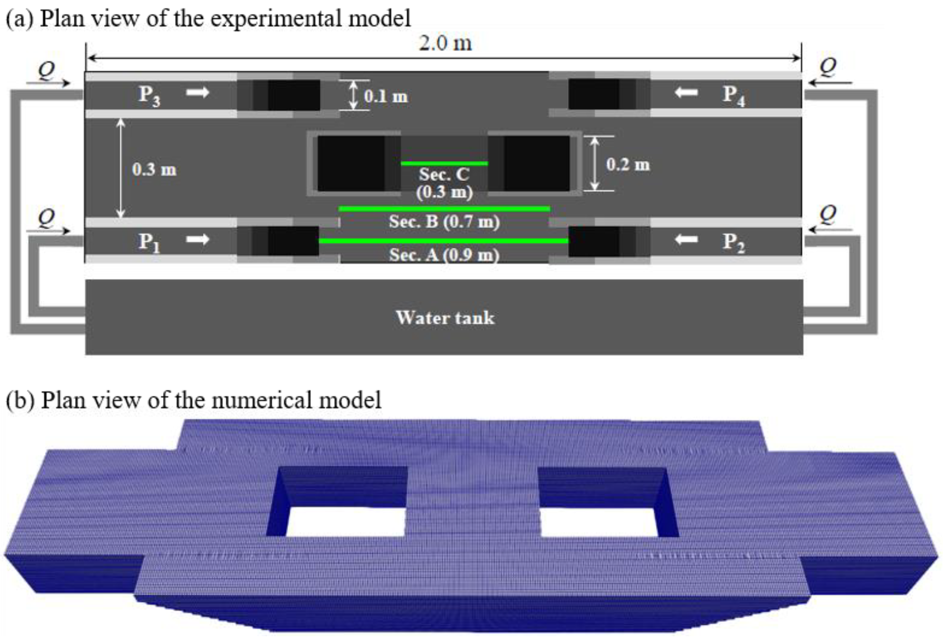
2.1. Numerical Model Description

In this research the OpenFOAM (Open Field Operation and Manipulation) model was utilized, which is an open-source computational fluid dynamics (CFD) program widely used in academia and industry to solve complex fluid dynamics problems through numerical methods. It provides a versatile collection of libraries that reproduces the simulation of fluid flow, turbulence, heat transfer, and other related physical processes. OpenFOAM offers various solvers and utilities that can be customized to address specific problems, making it a flexible and powerful tool in the field of computational engineering. For turbulent flow modeling by OpenFOAM, one of the primary approaches that is used frequently is solving the Reynolds-Averaged Navier–Stokes (RANS) equations. The RANS methodology simplifies the complex, instantaneous Navier–Stokes equations under turbulent conditions by decomposing the velocity and pressure fields into mean and fluctuating components. This results in a set of equations that describe the flow in terms of these averaged quantities. The RANS model adopts the Reynolds approximation of continuity and momentum equations as the following.
U i x i = 0 ,
U i t + U j U i x j = 1 ρ P x i + x j [ ν ( U i x j + U j x i ) ] x j u i u j ¯ ,
where U i is the time -averaged velocity in the Cartesian coordinate; P is the pressure; ρ is the fluid density; ν is the kinematic viscosity; u i j is the velocity fluctuation; and u i u j ¯ is the Reynolds stress. The k-ε model has been widely used in previous turbulence modeling, but it known to struggle in accurately simulating flows with adverse pressure gradients and leading to imprecise results in separated flows or strong curvature flows. Later, the k-w model addressed the limitations of the k-ε model by providing more accurate simulations of boundary layers. However, both the k-ε and k-w models are inadequate in modeling separated flows under strong adverse pressure gradients [31,32,33]. To address these shortcomings, the k-ω SST model proposed by Menter [34] has been used for the turbulence model, which uses the robust capabilities of the k-ω model for the near-wall regions and the k-ε model for the free flow regions. It has been shown that in complex geometric arrangements such as the subway model in this research, the k-ω SST model can reliably calculate flow characteristics which was the main reason for its utilization in this study.

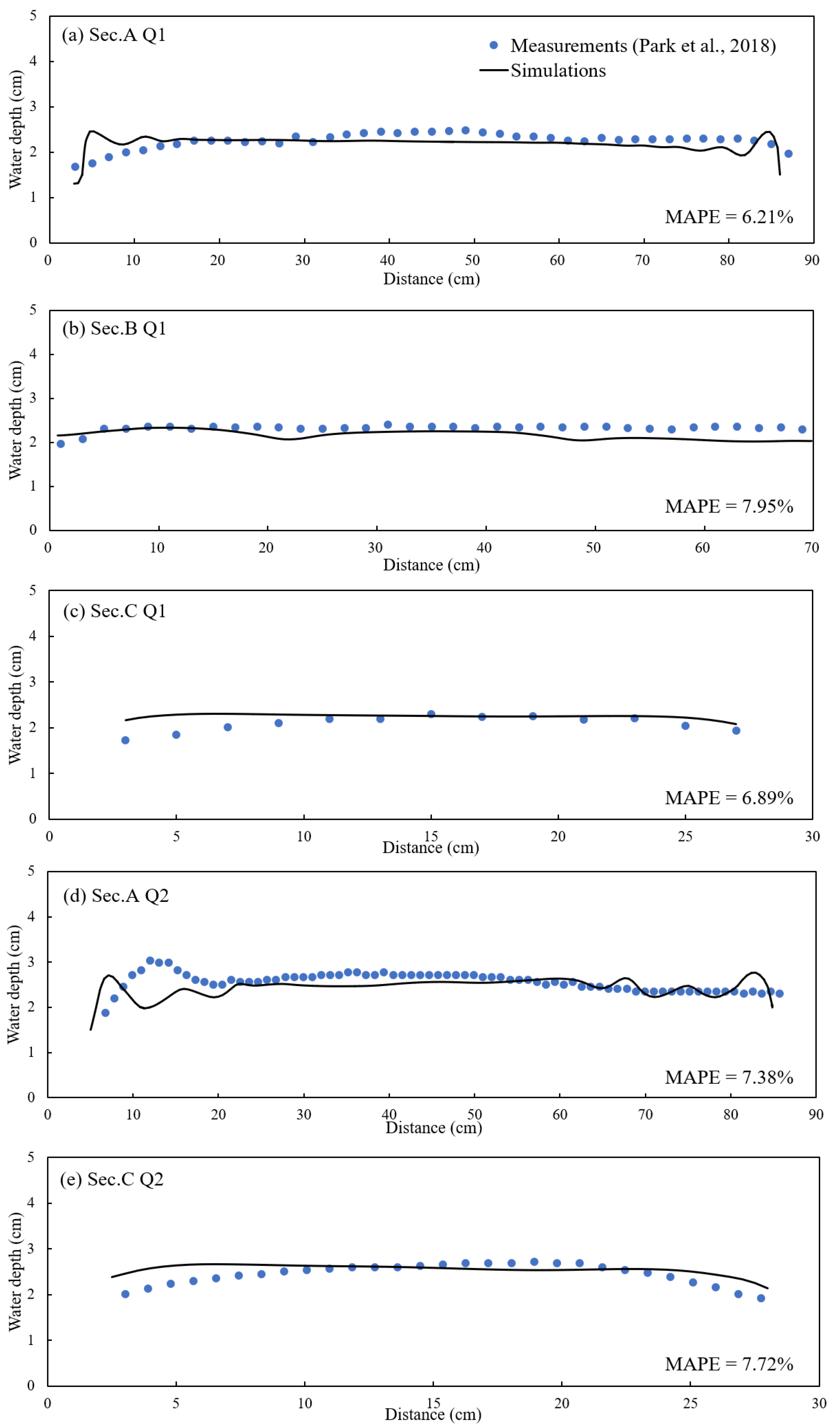
2.2. Model Setting and Validation

For the model setting, experiment results from former research were used for the validation of the model. Previously, the parameters of a typical subway platform were analyzed for the experimental model which was scaled down to 1/20 of the actual platform [35]. The underground subway station model that was used to measure the level of inundation in a flood situation is depicted in Figure 1a. Stairs from the ground to B1F are shown as P1234, two staircases to B2F are at the center of the model, and a flow supply device to simulate the rainwater inflow make up the experimental subway model. The total length of the model was 2.0 m and the width were 0.5 m, with the staircases leading to B1F having a width of 0.1 m and the staircases to B2F having a width of 0.2 m. Since typical subway station entrances are immediately connected to ground level, it was assumed in the creation of this experimental model that precipitation from urban roads would enter directly through the staircases.
For the numerical simulations, the OpenFOAM model with RANS was used to run the two-phase flow using a Volume of Fluid (VOF) method to capture the interface between the two fluids which are air and water. The VOF method is used to track the interface between two immiscible fluids. It involves solving a transport equation for the volume fraction of one of the phases typically denoted as alpha. The volume fraction alpha varies between 0 and 1, where 0 indicates pure air and 1 indicates pure water. The momentum equation is solved to update the velocity field U, which handles the coupling between velocity and pressure through the PIMPLE (merged PISO-SIMPLE) algorithm to ensure numerical stability and convergence.
For the mesh setup, the former experiment was recreated with the same size with mesh resolution size at 5 to 10 mm, consisting of the top stairways to the B1F area shown in Figure 1b. This accounted for the cells to be a find grid resolution (340 × 100 × 26), which discretization satisfies that the dimensionless wall height between 39.1 and 78.1 falls within 30 < z+ <200, which condition is prerequisite for using wall function for the solid-fluid boundaries of sidewalls and a channel bed. z + = z b τ w / ρ / ν is the dimensionless wall distance, where τ w is the wall shear stress, and z b is the distance from the walls and channel bed to the center of the first grid cell from these wall boundaries.
For this research, the flowrate of 3.78 × 10⁻⁴ m3/s for Q1 discharge and 4.92 × 10⁻⁴ m3/s for Q2 discharge that was used in the former experiment was used for the boundary conditions for the inlet for the comparison and validation of the numerical model. The measurement sections (Sec. A, Sec. B, and Sec. C) in Figure 1 are indicated by green lines which used the digital point gauge (PH-340, KENEK, Tokyo, Japan) to measure the water depth in the former experiment. These lines were chosen in order to examine the flooding characteristics of the subway station model for comparison between the experiment and the simulation. The boundary conditions for the numerical model used the specified flow rate above for the inlet, and the outlet for the central stairways which originally led to B2F used a zero-gradient boundary condition for the velocity and turbulence properties, and the pressure outlet boundary condition was assigned to be zero. At the walls, a non-slip boundary condition and wall functions were used for the velocity and turbulence variables, respectively. The time step was set to maintain the Courant number ( C r = U i Δ t / Δ x i ) to be less than 0.5, and for model validation, the flow simulations ran until the variables of flow velocity and depth converged to a steady-state condition.
The comparison between the measured inundation water depth values using digital point gauges in the experiment and the numerical simulation showed a good match overall shown in Figure 2, with the mean absolute percentage error being an average of 7.02% for Q1 discharge for the measured sections, and 7.55% for Q2 discharge, respectively. These results indicated that the simulated values were accurate enough for model validation in inundation modeling.

2.3. Safety Index

Safety indices were used to evaluate pedestrian stability during inundation flows. Most of these indices have been developed based on flood depth and flow velocity [36]. The indices from previous studies can be categorized into the following approaches [37]: (1) mechanical analysis-based formulas calibrated with experiments [8,14,15,16,17,18]; (2) empirical or semi-quantitative formulas [10,11,12,13,19,20]. The empirical or semi-quantitative formulas are also classified into flood intensity-based ( h U ) and momentum-based formulas ( h U 2 ) [18]. Considering these classifications for flood risk assessment, the following indicators were adopted to analyze pedestrian safety: critical velocity derived from mechanical analysis [15], specific force indicating the boundary value for walking safety [19], and two categorical indicators [11,12].
The risk of flooding can be assessed by evaluating the walking stability of the human body based on mechanical analysis. In a flood flow, friction, drag, gravity, buoyancy, and normal force act on the human body. The five forces caused by flood flow affect the walking stability of the human body and can be divided into a flood risk analysis method that considers sliding stability due to friction force and toppling stability due to moments [15]. Slip accidents occur when the drag generated by water flow is greater than the friction force between the feet of the human body and the ground surface and toppling accidents occurs when the moment generated by drag force by water is greater than the resisting moment due to the body weight [14]. Xia et al. [15] developed a calculation formula for the critical flow velocity ( U c ) at which sliding and toppling accidents can occur through experiments using a human body model. Equations (3) and (4) are the calculation formulas for the limit flow speeds for slipping and toppling accidents, respectively.
U c s = α ( h h p ) β m p ρ h p h ( a 1 h h p + b 1 ) ( a 2 m p + b 2 ) h p 2
U c t = α ( h h p ) β m p ρ h 2 ( a 1 h p 2 + b 1 h h p ) ( a 2 m p + b 2 )
where m p and h p are the target’s height (m) and weight (kg), respectively, and ρ is the density of water. If the actual water velocity is higher than the calculated critical flow velocity, there is a high chance of slipping and toppling accidents occurring. The coefficients for the above equation are shown in Table 1.
Ishigaki et al. [19] proposed specific force ( M 0 ) per unit width as an index for evacuating evacuation safety and suggested boundary values for the safety based on experimental results. The marginal specific force is calculated as the following equation with the sum of dynamic and hydrostatic pressure:
M 0 = U 2 h g + h 2 2 ,
where U is the depth-averaged velocity; h is the inundation depth; g is the gravitational acceleration. Ishigaki et al. [19] also proposed a specific force range in which safe evacuation is possible and suggested that safe evacuation is possible when M0 < 0.125 m2 for adult men, M0 < 0.1 m2 for elderly men, and M0 < 0.08 m2 for elderly women.
A categorical indicator based on flood intensity has been proposed to evaluate the risk of inundation flows using more detailed criteria. Defra and EA [11] presented the following equation to calculate Flood Hazard Degree (FD) using flood depth and flow velocity:
F D = h ( U + 0.5 ) .
The flood risk assessment method using FD is classified into 4 levels: “Low” for FD ≤ 0.75, “Moderate” for 0.75 < FD ≤ 1.25, “Significant” for 1.25 < FD ≤ 2.0, and “Extreme” for 2.0 < FD. Kreibich et al. [12] analyzed the risk of flooding by proposing the Flood Intensity Factor (FIF).
F I F = h 2 U .
The flood risk assessment method using FIF is classified into three stages: “Attention” if FIF ≤ 0.5, “Alert” if 0.5 < FIF ≤ 1.5, and “Serious” if 1.5 < FIF. These various flood risk assessment methods will be calculated using the inundation simulation results for detailed analysis.

3. Results

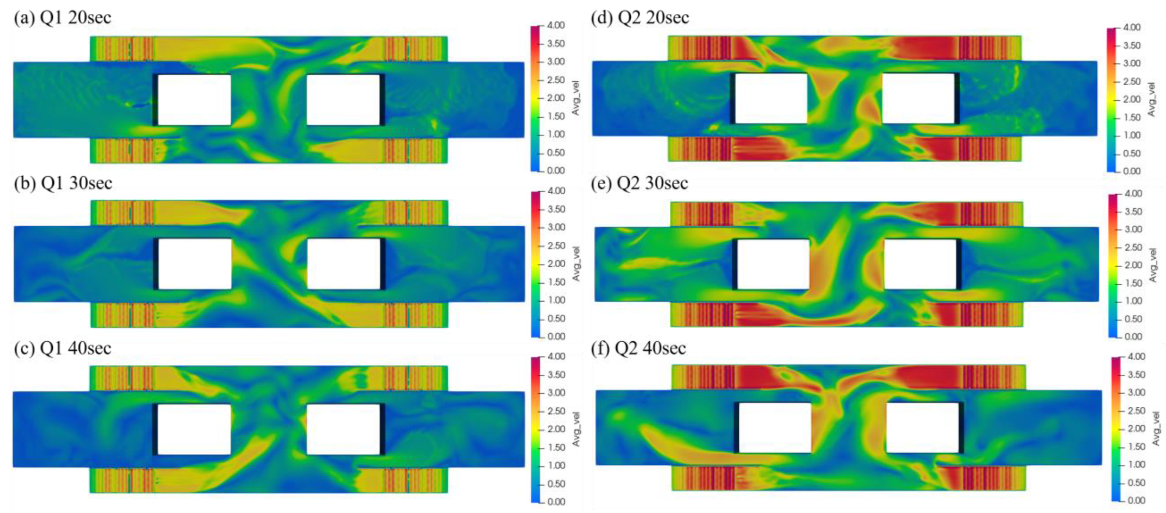
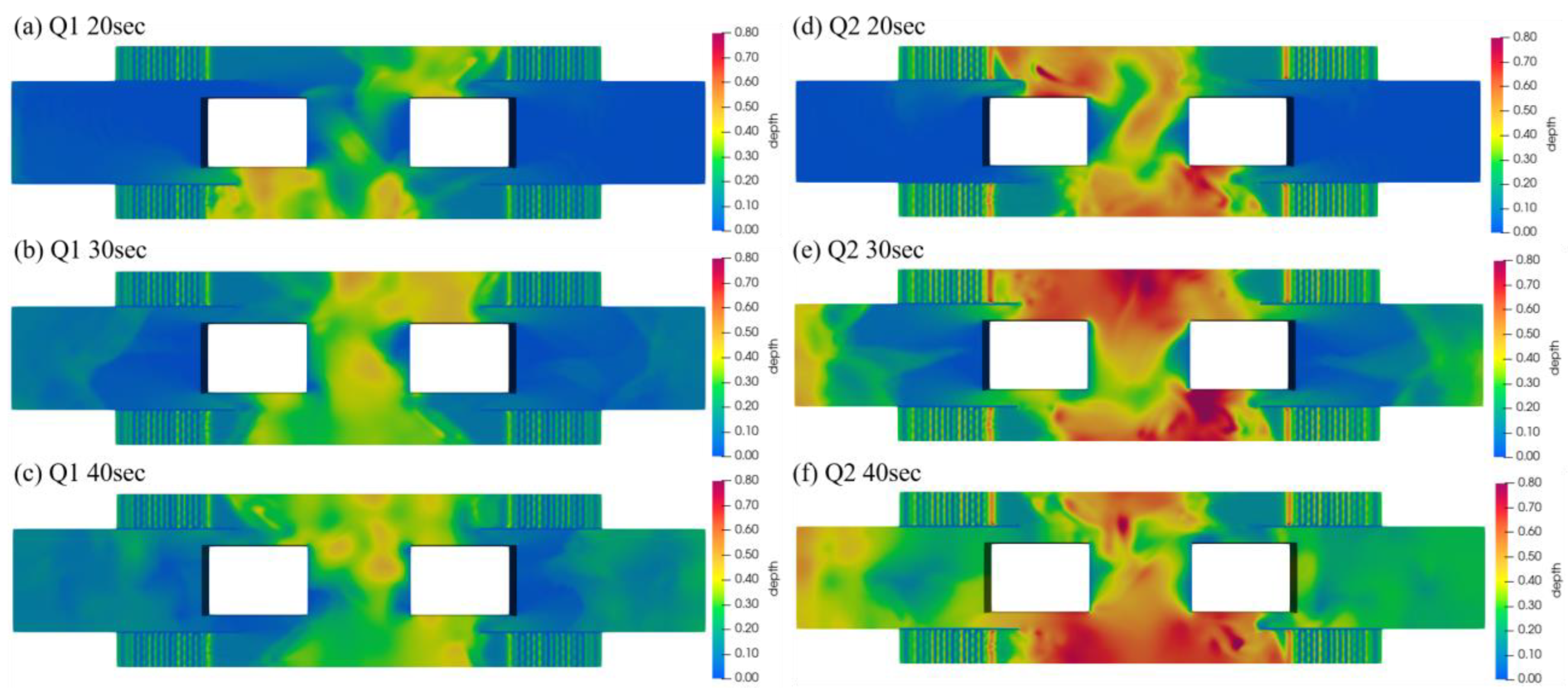
3.1. Simulation Results

The simulation using OpenFOAM for various flood cases for the model in full size instead of the 1/20 in the experiment for the underground station was performed for continuous inundation analysis. The original simulation discharge values were changed to 0.67 m3/s as discharge Q1 by using the law of similitude, which was the original inflow discharge value of the prototype. Additional simulation conditions were set assuming inflow coming in through the ground stairs, and as the overflow depth of rainwater was assumed to be 0.4 and 0.5 m, the flowrate of 1.35 and 1.88 m3/s for discharge Q2 and Q3 was determined through the weir formula assuming a falling flow [23].
Q = C d b g H 1.5 .
where C d is the discharge coefficient, H is the overflow depth from the top stairs, and b is the width of the water flow from the stairs leading to B1F. Coefficient C d was assumed to be 0.85 using the coefficient values in situations where rainfall at the roads entered into the underground that were changed to discharge values [23]. The assumed maximum overflow depth of 0.5 m is at the knee height of an adult.
To analyze the effect of flood inundation and its drag force on the human body, additional human models, which depicted 60-year-old females who would be considered feeble to inundation situations were employed in the numerical simulation. To find the flooding effect at the underground stations, the location of human models was placed in 3 locations, which were the middle of the stairs leading to B1F, a location right below the stairs, and a location which was positioned at a distance from the stairs (Figure 3).
First, the simulation results depicting the entire model were analyzed. Figure 4 shows the depth-averaged velocity of the results of the simulation with discharge inflow of Q1 and Q2 which are 0.67 and 1.33 m3/s flowing through all the stairs. The results are shown from 20 to 40 s after the inflow starts from the four stairs, and the inundation level continues to rise as varying velocities of the fluid are shown as it flows around the stairs into the outflow area located at the center of the model. The non-simulated areas at the center would be where the stairs leading to B2F were located in the original experimental model. The highest velocity occurred at the bottom of the stairs with over 3 m/s up to 4 m/s velocity, and the central passage was flooded with high velocities up to 2.5 m/s. Since the flow came through all the stairs, the flow propagation would collide at the center of the model, and the inundation depth would show an instantaneous increase and then later decrease into a lower depth value, as the accumulated water flows to the outflow area in the center. This is displayed in Figure 5e,f as the inflow time changes from 30 s to 40 s where some areas show inundation depth decreasing as the flow continued to 40 s the water reached the outflow region out of the model.

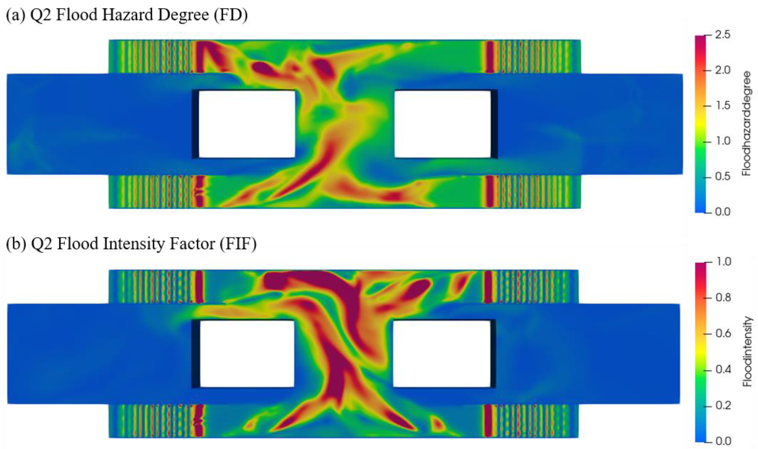
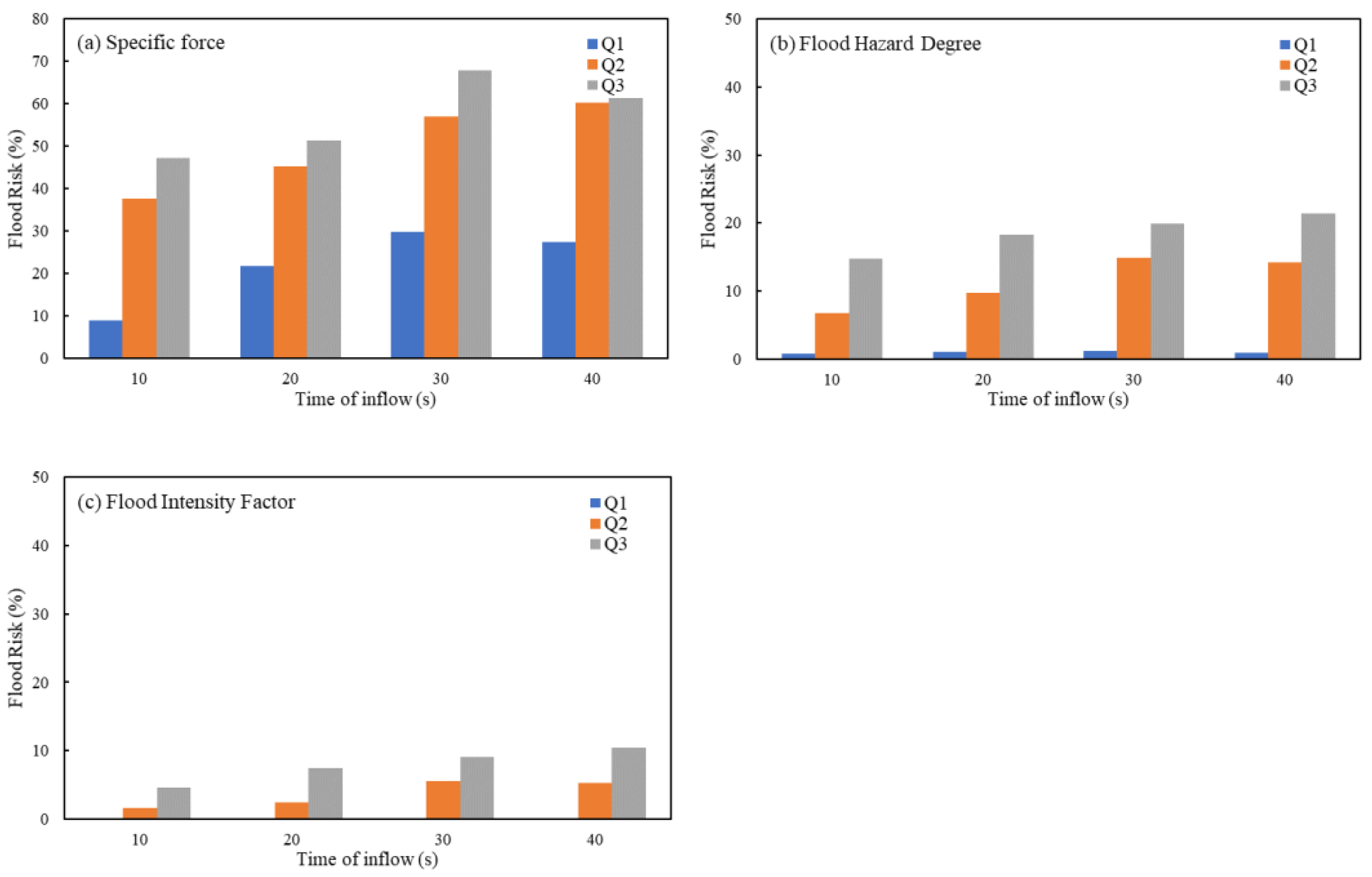
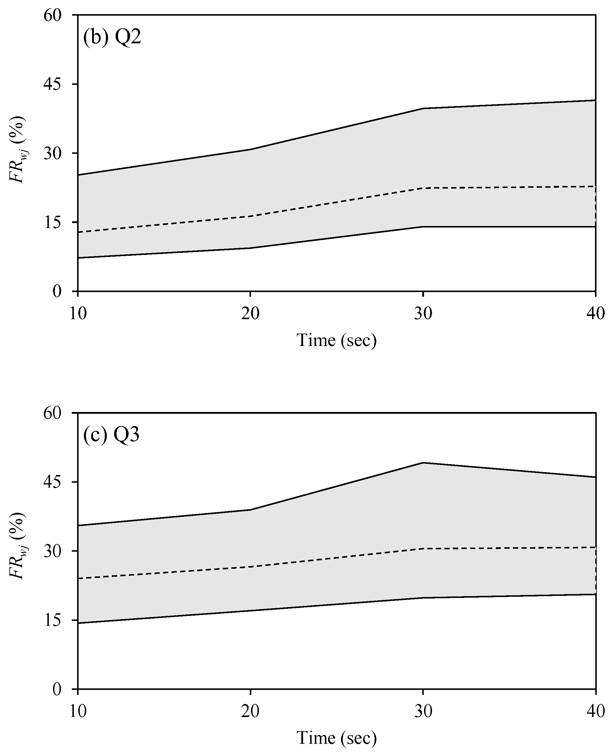
3.2. Flood Hazard Area Analysis

To analyze where dangerous and safe areas in the model are located and their degree of safety, various indices have been used to evaluate how safe certain areas are. Figure 6 shows the result of the estimation of specific force from the Q1 and Q2 inflow cases. In the lower inflow case, the specific force had high values over 0.125 m2 nearby and below the stairs which is a value that causes difficulty in evacuation. As the flow increased by almost two times in Figure 6b compared to Figure 6a, the areas considered unsafe by specific force criteria have enlarged showing most of the area near the flooded stairs and areas reaching the outflow area are over the limit of 0.125 m2 and reach values near 0.4, showing the effects of higher flowrate to specific force estimated values.
Other safety criteria such as the Flood Hazard Degree (FD) and Flood Intensity Factor (FIF) were also applied to the Q2 inflow case in Figure 7. Flood Hazard Degree values over 2.0 are known to be ‘Extreme’ hazards and values of FD over 2 are shown right below the stairs and into the central area in Figure 7a. Flood Intensity Factors over 1.5 are considered ‘serious’ hazards which are shown clearly in the central areas of Figure 7b. For the evaluation of safety in the entire model, a method using the ratio (%) of the flooding risk for each simulation case compared to the maximum risk in Figure 8 by time of inflow was adopted. The calculated and normalized values were compared using a single value; in the case of a specific force in Figure 8a, areas above values of 0.125 m2 were considered to be flood risk areas, and the ratio of the flood risk areas divided by the total area was calculated. In the case of FD, it used an evaluation method where after assigning the safety interval states with 0 to 3 points (0 for “Low”, 1 for “Moderate”, 2 for “Significant”, 3 for “Extreme”), the sum of the points times the assigned area was divided by the maximum risk which was 3 points for all the areas. FIF was evaluated in a similar way; after evaluating the intervals in 3 states from 0 to 2 points, the maximum risk value of 2 points for all areas was divided. This method assumes the risk ratio value compared to the highest danger situation in the evaluation area.
Figure 8 shows flood risk values increasing by the time of inflow in most situations, however, some cases such as Q3 specific force in Figure 8a and Q2 FD and FIF in Figure 8b,c showed that some flood risk values increased until 30 s but became lower in 40 s. This result somewhat matches the velocity and depth results shown in Figure 4 and Figure 5, where the flow would collide at the center of the model, and the inundation depth would show an instantaneous increase and then later converge into a lower steady state as the water would reach the center area for outflow. This shows some insight that continuous inflow does not directly lead to lower safety in underground stations, since some structures such as the model used in this study have the flow leading to the outflow (originally stairs to the lower floor B2F) causing lower inundation depth as time passes. This could be a characteristic of underground subway stations with certain types of stairways and passages.
Additional safety criteria using the risk of sliding and toppling stability using Equations (3) and (4) according to former research [9] are estimated in Figure 9 and Figure 10. The variables for height and weight used average values targeting 60-year old females. Figure 9a shows the estimated value of sliding critical velocity minus simulated velocity at Q3. This shows that as the value is above 0, it is considered safe as the simulated velocity value was below the estimated sliding critical velocity value. Figure 9b is similar, except it used toppling critical velocity minus simulated velocity. Figure 10 shows the percentages of flood risk increase as inflow time changed, and while most cases had higher flood risk with higher inflow time, cases in Q2 showed the sliding and toppling flood risks decreased from 30 s to 40 s, showing similar tendencies with the results using specific force, FD and FIF.

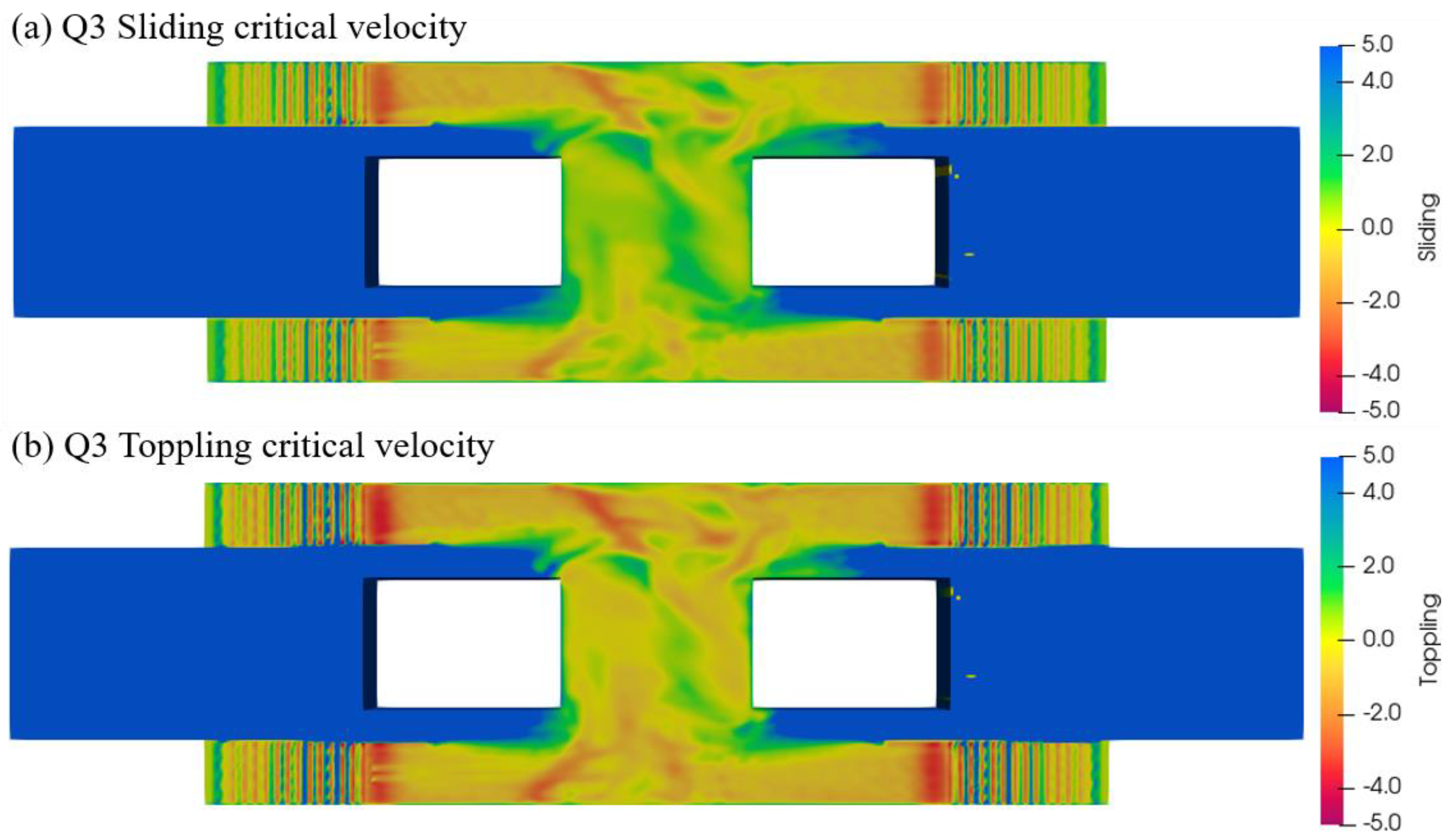
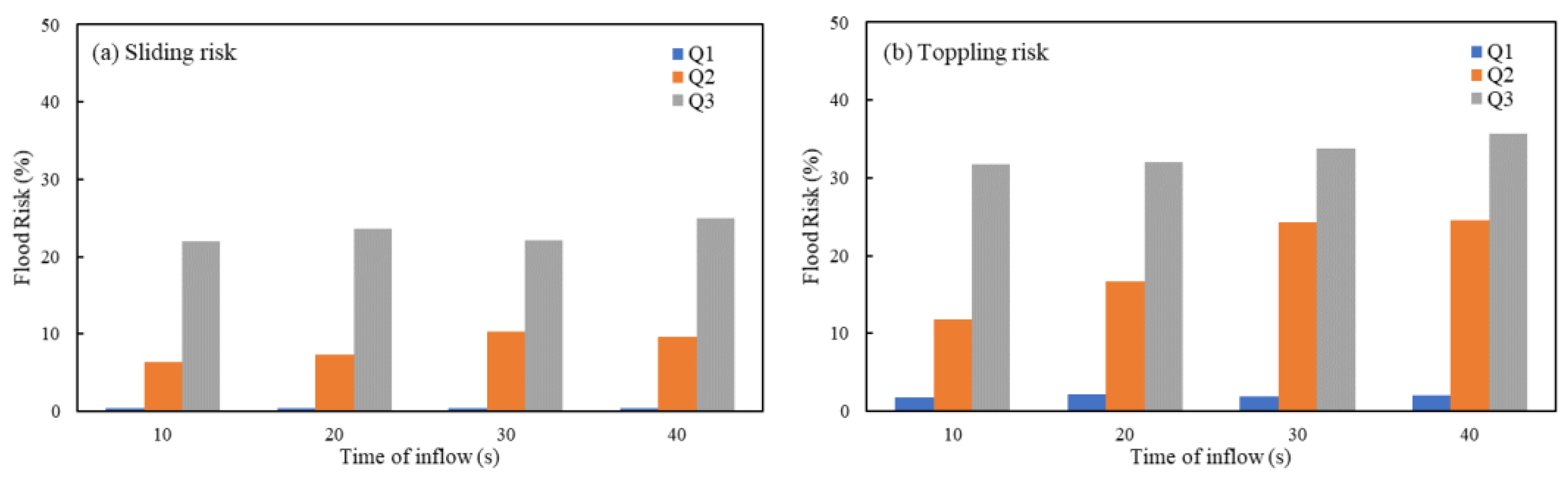
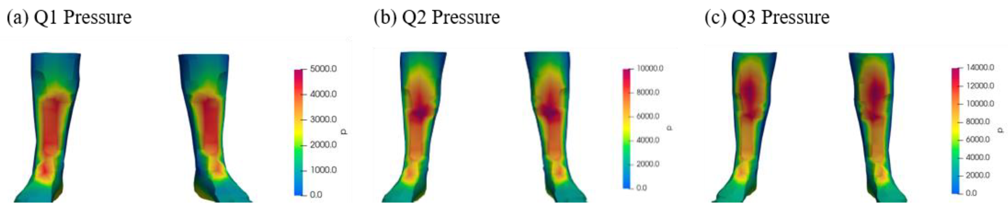
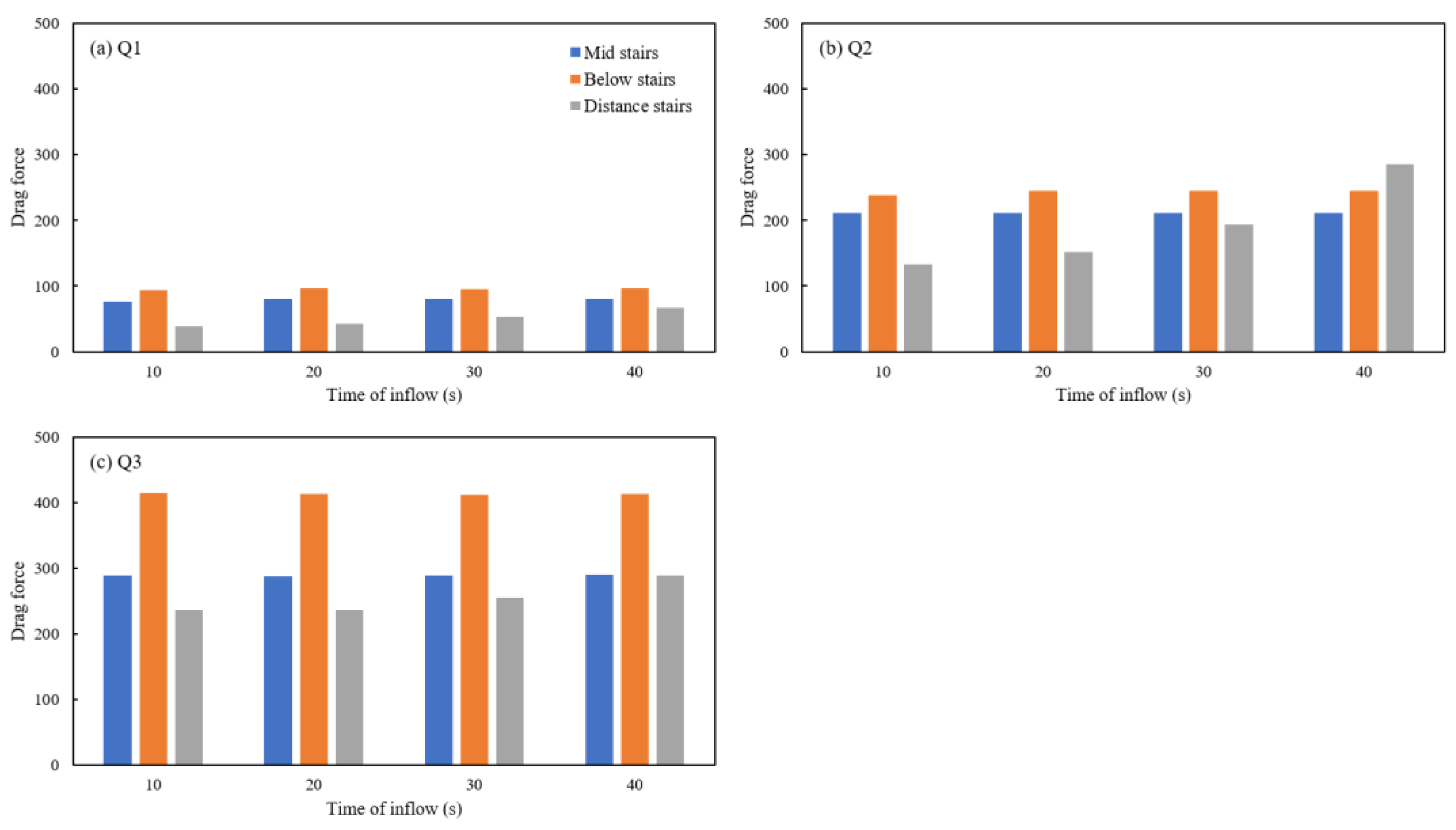
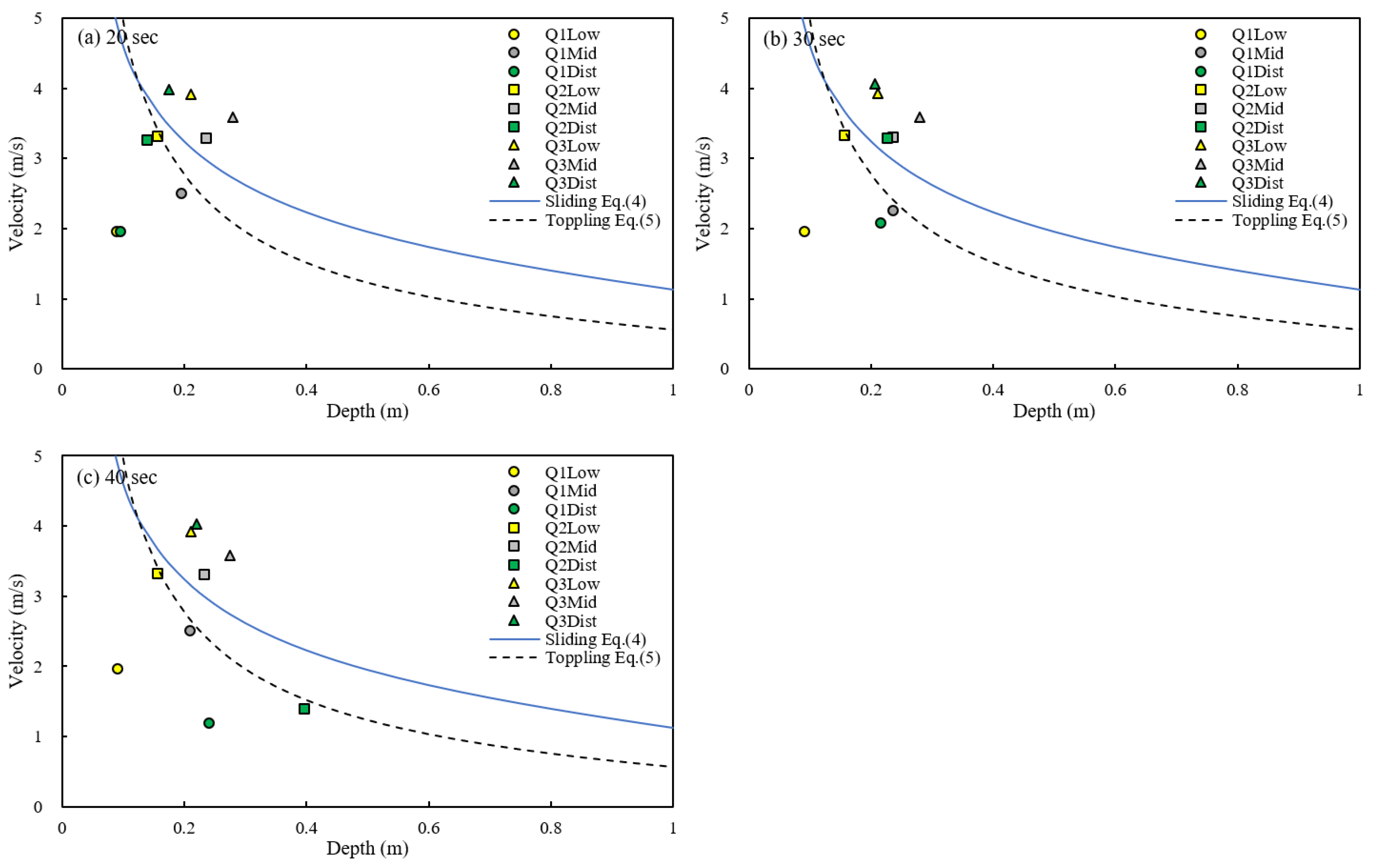
3.3. Flow Analysis and Drag Force at Human Models

When underground space is flooded, stairs can become a major evacuation facility but also can cause flood flow with strong momentum, which can affect walking stability. Therefore, we analyzed the effect on safety by analyzing the time change in drag force caused by flood flow for people trying to evacuate by stairs. For analysis using human models to specific areas near and on the stairs, the changes to the external force to the human body due to flow changes were investigated.
Pressure changes occurring in the lower body of the human model according to changes in water depth and flow rate were analyzed. Figure 11 shows the pressure from the water flow applied to the lower legs of the human model in the various flood simulations of Q1, Q2, and Q3. The maximum pressure location is shown, which depends on the flowrate and depth of the water flow. Depending on the flowrate, the pressure from the inundation shows the pressure forming from the ankles to the calf area, and higher flowrate shows higher values that reach maximum values near the knee, as the inundation depth also increases in higher flow rates. Lower flowrates of Q1 with 0.67 m3/s showed maximum pressure occurring around 0.16 m in depth, while higher flowrates of Q3 with 1.88 m3/s had the maximum pressure at about 0.28 m in depth with higher inundation depth.
Then, the changes to the velocity and depth near the 3 models located in different places near and on the stairs were analyzed. Figure 12 shows the simulated velocity result and water surface near the 3 models each located below the stairs, middle of the stairs, and distance from the stairs. For the model right below the stairs in Figure 12a–c, the velocity reached up to 6.4 m/s, while the depth was about 0.4 m. Figure 12d shows the model in the middle of the stairs, where the nearby velocity was 4 m/s, and the depth was 0.1 m. The velocity would eventually increase up to 4.6 m/s and 0.37 m in depth in Figure 12f. Finally, in Figure 12g–i, the model located distance from the stairs showed the velocity increasing up to 2.9 m/s, and the depth was 0.65 m. This depicts the hydraulic changes near the models in different locations of the underground station.
As a result of the pressure change in the lower body of the human model according to changes in the flowrate in Figure 13, the size of the drag force increased by approximately 304%, as the flow increased by about 176% on average. This shows the effect of flow rate conditions on the size of the drag force on the human model. Higher drag force values are seen below the stairs than the mid-stairs, which is due to the gravitational acceleration being applied to the flow coming downstairs. This conforms to former research where jet flow below stairs would affect human stability [29]. Also, the drag force changes timewise for different human model locations were analyzed. It showed that as the human model was located at a certain distance from the stairs, the drag force would increase accordingly to the time of inflow, but values of drag force at the center of stairs and below stairs did not have difference timewise, due to the fact that high flow would have instantaneous effect of drag force, as the flood flow propagation ended within 10 s within the stairs, so there was almost no change in drag force over time. On the other hand, for the model located at a distance from the stairs, the drag force gradually increased up to 40 s.

4. Discussions

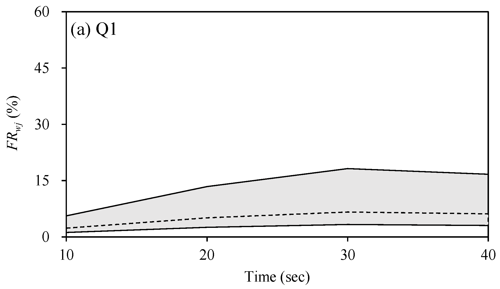
4.1. Temporal Variations of Pedestrian Safety near Staircase

Flooding is an unsteady phenomenon and the flood hazard needs to be assessed according to time [36]. Thus, DEFRA and EA [11] recommend considering the spatial and temporal variations of flood depth and velocity. In this research, the human body models in the simulation were used to determine the velocities at various water depths to determine the instability for both sliding and toppling in the three areas for a time span as seen in Figure 10. For additional analysis, instead of showing the percentage of risk to the entire model area, the results adjacent to human models for each simulation were plotted as a graph using the relations between the critical velocity and simulated velocity and water depth shown in Figure 14 using simulated data from 20 to 40 s. The critical velocity related to sliding or toppling accidents depends on the water depth after the depth stabilizes; the critical velocity causing instability is related according to depth in former research [15]. Figure 14 shows the results of the nine case simulations with three discharge conditions and three human model locations that were carried out to determine the relations to sliding and toppling instability compared to the estimated critical velocity from Equations (3) and (4). Results with Q1 cases were usually plotted below the estimated critical velocity equations showing stability, and Q3 cases were plotted above the critical velocity equations showing instability. In the Q2 distance case, the simulated values showed changes to the stability with inflow time changes shown in green boxes in the figures. In that case, the velocity would show a slight increase from 20 to 30 s and then decrease greatly at 30 s to 40 s, which resulted in the plots being positioned over the sliding critical velocity in Figure 13b, and then becoming lower than the critical velocity shown in Figure 13c. Although these plots only show results adjacent to the human model, it has some concurrency with the results of Figure 10, where the sliding and toppling risk increased from 20 to 30 s, then decreased at 30 to 40 s. This shows that hydrodynamic characteristics in a flooding subway area can alter over time, so the risk that floodwaters pose to humans can vary according to time and location.
These temporal risk changes indicate that pedestrians located at a distance from the stairs could face dangerous situations as the flow conditions exceed the sliding and toppling criteria due to flow propagation. However, pedestrians encounter safer conditions after the flood wave has passed and the flow depth has stabilized as displayed in the Q2 distance case. Usually, the main escape routes for pedestrians are stairs, but approaching them can be hazardous when the flood waves first occur at the beginning of inundation in real-world subways. In such disaster situations, accurate supporting information enhances evacuation efficiency [38]. Therefore, control by emergency response teams or management is necessary when flooding first begins, so there would be robust safety measures and evacuation strategies that inform and control people who are escaping that they should not rush right away and should evacuate only after the flood wave has stabilized.

4.2. Evaluations of Uncertainty in Flood Hazard Assessments According to Safety Indices

To ensure the safe evacuation of citizens in the event of underground station flooding, it is essential to conduct a comprehensive flood risk assessment across the entire facility. The flood risk assessment results lie in their applicability to subway flooding disasters, and their potential to aid in determining pedestrian evacuation routes. Haghani and Yazdani [38] demonstrated that while information supporting evacuation choices can improve evacuation efficiency, inefficient or incorrect information may have a more substantial negative impact on effectiveness. Additionally, they found that simple and actionable instructions can further enhance evacuation efficiency [39]. These findings suggest that providing a single, accurate indicator is more advantageous for making evacuation route decisions than relying on multiple safety indices, which could cause confusion for evacuees or subway platform managers.
In this study, flood hazard indices based on the empirical or semi-quantitative formulas ( M 0 , F D , and F I F ) were utilized for flood risk assessment within the subway platform (Figure 8). Additionally, areas exceeding the toppling and sliding velocities ( U c p and U c t ) were calculated to classify risky regions for flooding (Figure 10). Figure 8 and Figure 10 demonstrate that the flood risk assessment results vary depending on the chosen assessment index. F I F tends to underestimate the flood hazard area compared to other indices, while M 0 tends to overestimate it. Consequently, in case Q1, the flood hazard area determined by the M 0 criterion was estimated to be 8.9% to 29.7% over time, whereas the results from the F I F assessment indicated that the entire area was safe. The use of momentum is influenced predominantly by flow velocity when water depth is low [12]. Therefore, there is a risk of overestimating or underestimating flood hazards depending on the assessment indices used, underscoring the importance of considering multiple indices to arrive at a comprehensive conclusion.
Figure 15 presents the flood risk assessment results based on considering all possible weighting scenarios for the five flood hazard assessment indices used in this study ( M 0 , F D , F I F , U c t , and U c s ) according to the following formula:
F R w j = i = 1 5 w i j F R i ,
where F R i is the flood risk value for the i flood risk analysis index; w i j is the weighting value for the jth weighting scenario; F R w j is the weighted flood risk value. Since a reliable objective criterion for determining the appropriate weights for these indices was insufficient, 45 weighting scenarios were generated to address potential bias in the assignment of w i j [40]. These scenarios were created by combining weighting values ranging from 0.1 to 0.6 for each index, ensuring that the summation of w i j in each scenario equals one. In Figure 15, the upper and lower limit lines are the maximum and minimum values of the weighted average flood hazard risk ( F R w j ), and the dashed line is the averaged values of F R w j for 45 weighting scenarios. The maximum values of F R w j were 6.6%, 22.8%, and 30.8% in Cases Q1, Q2, and Q3, respectively. The standard deviation of weighted average values in Case Q1 ranged from 0.9 percentage points to 3.34 percentage points over time. This range broadened in Cases Q2 and Q3, with standard deviations of 3.7 to 5.7 percentage points and 4.2 to 5.8 percentage points, respectively, indicating increased uncertainty in the flood risk assessment results. The upper limit was obtained when M 0 had the maximum weighting value of 0.6, while the lower limit appeared when F I F had the maximum weighting. The upper limit is farther from the average value of F R w j than the lower limit, indicating an increase of uncertainty when using M 0 . The averaged F R w j indicates that the rate of flood risk increase accelerates until 30 s after flood occurrence, after which the rate begins to decrease. These averaged values of F R w j was close to the assessment results using U c t compared to other indices, with an average difference of 27.3% between the averaged values of F R w j and U c t across all cases. It implies that U c t provides reasonable safety analysis results compared to other indices. These results are in line with Musolino et al. [25] and Kvočka et al. [41], where the mechanical analysis based on physical analysis is preferred over empirical formulas for analyzing evacuation safety.
To evaluate pedestrian safety during underground space flooding, various safety indices have been used. These indices have shown that even under the same flooding conditions, they can yield different results. This study aimed to reduce the uncertainty associated with each evaluation indicator by employing a weighted average approach. As a result, it was demonstrated that the weighted average value is closest to the value of U c t . Other uncertainties lie in the comparison of experiment results to simulation results. The experimental data and its measurement contain uncertainty as there are scale effects, measurement errors, boundary condition representation, and challenges in reproducing and generalizing results from controlled lab environments to actual real-world subway systems. Also, the simulations have model assumptions, data limitations, and uncertainty from numerical methods. These factors can lead to errors and discrepancies between simulated and real-world inundation scenarios.

5. Conclusions

In this study, the investigation of inundation in subway platforms was conducted to find the safety criteria for citizens against flooding. The inundation characteristics and safety areas were analyzed and validated in a subway station model using experimental inundation depth measurements and numerical simulations. Then, by utilizing five risk evaluation indices—including specific force ( M 0 ), Flood Hazard Degree (FD), Flood Intensity Factors (FIF), toppling velocity ( U c t ), and sliding velocity ( U c s )—the effects of increased inflow on water velocity and depth were studied using the simulation. The flood risk assessment analysis results show that assessments using M 0 could increase uncertainty by broadening the evaluation of risky areas compared to other indices. The effects on human models on and near the stairways using pressure and drag force were also presented. With this research, simulations with various conditions showed that hydrodynamic characteristics and their effects on human stability in a flooding subway area can alter over time. Overall, these risk assessments would provide a criterion for flood situations in subway stations.
The utilization of inundation simulation results of subways in this research can be used by engineers for identifying vulnerable points in the subway infrastructure. By understanding how water could flow and accumulate during floods, engineers can design better drainage systems for the subways. Also, city planners can plan risk mitigation strategies by using inundation simulations for comprehensive flood risk management plans. Emergency response teams could use simulation models to predict the progression of flooding and make informed decisions on how to manage evacuations and prepare detailed plans for emergency personnel deployment. The advantages of the proposed simulation and research are that 3D models can accurately capture the complex flow patterns within subway systems, especially in vertical areas such as stairs. Also, using human models based on real data can allow better prediction of force applied to humans in flooding situations. 3D models can handle complex interactions between water and air in underground systems, which is particularly useful for simulating scenarios where water levels change rapidly such as fast flooding. However, the simulation results presented in this study have the limitation of only analyzing one human model due to the computation time and complexity of the geometry setup. In actual disaster situations, evacuation by crowds occurs, so flood risk analysis for these situations is necessary.
Future research could involve using laboratory experiments for risk assessment on crowd evacuation and temporal/spatial variation of flood risk evaluation and its simulation validation. Also, additional analysis on uncertainty regarding flood risk assessment and evacuation time could be conducted.

Author Contributions

Conceptualization, J.S., D.S.R. and I.P.; methodology, J.S. and I.P.; software, J.S.; validation, J.S. and I.P.; writing—original draft preparation, J.S., D.S.R. and I.P.; writing—review and editing, J.S. and I.P.; project administration, I.P. and J.S.; funding acquisition, I.P. All authors have read and agreed to the published version of the manuscript.

Funding

This research was supported by the Korea Agency for Infrastructure Technology Advancement (KAIA) grant funded by the Ministry of Land, Infrastructure and Transport (Grant No. RS-2023-00238018).

Institutional Review Board Statement

Not applicable.

Informed Consent Statement

Not applicable.

Data Availability Statement

The data presented in this study will be shared by the authors if requested.

Acknowledgments

This research was supported by the Korea Agency for Infrastructure Technology Advancement (KAIA) grant funded by the Ministry of Land, Infrastructure and Transport.

Conflicts of Interest

The authors declare no conflicts of interest.

References

  1. Joo, J.; Kim, T.-H. An experimental study on evacuation ability during underground space inundation. J. Korean Soc. Hazard Mitig. 2015, 15, 189–196. (In Korean) [Google Scholar] [CrossRef]
  2. Shin, E.; Kim, H.J.; Rhee, D.S.; Eom, T.; Song, C.G. Spatiotemporal flood risk assessment of underground space considering flood intensity and escape route. Nat. Hazards 2021, 109, 1539–1555. [Google Scholar] [CrossRef]
  3. Wang, G.; Liu, Y.; Hu, Z.; Zhang, G.; Liu, J.; Lyu, Y.; Gu, Y.; Huang, X.; Zhang, Q.; Liu, L. Flood Risk Assessment of Subway Systems in Metropolitan Areas under Land Subsidence Scenario: A Case Study of Beijing. Remote Sens. 2021, 13, 637. [Google Scholar] [CrossRef]
  4. Gong, Y.; Xu, X.; Tian, K.; Li, Z.; Wang, M.; Li, J. Subway station flood risk management level analysis. J. Hydrol. 2024, 638, 131473. [Google Scholar] [CrossRef]
  5. Jiang, Y.; Gao, Y.; Yuan, Q.; Li, X.; Sun, K.; Sun, L. Simulation and Risk Assessment of Flood Disaster at the Entrance to a Rail Transit Station under Extreme Weather Conditions—A Case Study of Wanqingsha Station of Guangzhou Line 18. Water 2024, 16, 2024. [Google Scholar] [CrossRef]
  6. Shirvani, M.; Kesserwani, G. Flood–pedestrian simulator for modelling human response dynamics during flood-induced evacuation: Hillsborough stadium case study. Nat. Hazards Earth Syst. Sci. 2021, 21, 3175–3198. [Google Scholar] [CrossRef]
  7. Cao, S.; Wang, M.; Zeng, G.; Li, X. Simulation of Crowd Evacuation in Subway Stations Under Flood Disasters. IEEE Trans. Intell. Transp. Syst. 2024, 25, 11858–11867. [Google Scholar] [CrossRef]
  8. Abt, S.R.; Wittler, R.J.; Taylor, A.; Love, D.J. Human stability in a high flood hazard zone. J. Am. Water Resour. Assoc. 1989, 25, 881–890. [Google Scholar] [CrossRef]
  9. RESCDAM. The Use of Physical Models in Dam-Break Flood Analysis: Rescue Actions Based on Dam-Break Flood Analysis; Final Report of Helsinki University of Technology; Helsinki University of Technology: Helsinki, Finland, 2000. [Google Scholar]
  10. Penning-Rowsell, E.C.; Floyd, P.; Ramsbottom, D.; Surendran, S. Estimating injury and loss of life in floods: A deterministic framework. Nat. Hazards 2005, 36, 43–64. [Google Scholar] [CrossRef]
  11. Department of the Environment, Food and Rural Affairs (DEFRA) and Environment Agency (EA). Flood Risks to People (Phase 2): Methodology; DEFRA: London, UK, 2006.
  12. Kreibich, H.; Piroth, K.; Seifert, I.; Maiwald, H.; Kunert, U.; Schwarz, J.; Merz, B.; Thieken, A.H. Is flow velocity a significant parameter in flood damage modelling? Nat. Hazards Earth Syst. Sci. 2009, 9, 1679–1692. [Google Scholar] [CrossRef]
  13. Mani, P.; Chatterjee, C.; Kumar, R. Flood hazard assessment with multiparameter approach derived from coupled 1D and 2D hydrodynamic flow model. Nat. Hazards 2014, 70, 1553–1574. [Google Scholar] [CrossRef]
  14. Jonkman, S.N.; Penning-Rowsell, E. Human instability in flood flows. J. Am. Water Resour. Assoc. 2008, 44, 1208–1218. [Google Scholar] [CrossRef]
  15. Xia, J.; Falconer, R.A.; Wang, Y.; Xiao, X. New criterion for the stability of a human body in floodwaters. J. Hydraul. Res. 2014, 52, 93–104. [Google Scholar] [CrossRef]
  16. Musolino, G.; Ahmadian, R.; Falconer, R.A. Comparison of flood hazard assessment criteria for pedestrians with a refined mechanics-based method. J. Hydrol. X 2020, 9, 100067. [Google Scholar] [CrossRef]
  17. Zhu, Z.; Zhang, Y.; Gou, L.; Peng, D.; Pang, B. On the physical vulnerability of pedestrians in urban flooding: Experimental study of the hydrodynamic instability of a human body model in floodwater. Urban Clim. 2023, 48, 101420. [Google Scholar] [CrossRef]
  18. Martínez-Gomariz, E.; Gómez, M.; Russo, B. Experimental study of the stability of pedestrians exposed to urban pluvial flooding. Nat. Hazards 2016, 82, 1259–1278. [Google Scholar] [CrossRef]
  19. Ishigaki, T.; Asai, Y.; Nakahata, Y.; Shimada, H.; Baba, Y.; Toda, K. Evacuation of aged persons from inundated underground space. Water Sci. Technol. 2010, 62, 1807–1812. [Google Scholar] [CrossRef]
  20. Arrighi, C.; Oumeraci, H.; Castelli, F. Hydrodynamics of pedestrians’ instability in floodwaters. Hydrol. Earth Syst. Sci. 2017, 21, 515–531. [Google Scholar] [CrossRef]
  21. Lazzarin, T.; Viero, D.P.; Molinari, D.; Ballio, F.; Defina, A. Flood damage functions based on a single physics- and data-based impact parameter that jointly accounts for water depth and velocity. J. Hydrol. 2022, 607, 127485. [Google Scholar] [CrossRef]
  22. Arrighi, C.; Pregnolato, M.; Dawson, R.J.; Castelli, F. Preparedness against mobility disruption by floods. Sci. Total Environ. 2019, 654, 1010–1022. [Google Scholar] [CrossRef]
  23. Nakasaka, Y.; Ishigaki, T. Vulnerability to mega underground inundation and evacuation assuming devastating urban flood. J. Disaster Res. 2021, 16, 321–328. [Google Scholar] [CrossRef]
  24. Liu, F.; Ren, C.; Chen, Y. Flood risk investigation of pedestrians and vehicles in a mountainous city using a coupled coastal ocean and stormwater management model. J. Flood Risk Manag. 2024, 17, e12979. [Google Scholar] [CrossRef]
  25. Musolino, G.; Ahmadian, R.; Xia, J. Enhancing pedestrian evacuation routes during flood events. Nat. Hazards 2022, 112, 1941–1965. [Google Scholar] [CrossRef]
  26. Lin, Z.; Hu, S.; Lin, H. Flow pattern and escape hazards of people from flood intrusion into the staircase of underground spaces with multiple rest platforms. Buildings 2024, 14, 941. [Google Scholar] [CrossRef]
  27. Liang, C.; Guo, K.; Guan, M. Computational hydraulics and hazard assessment of flooding on underground staircases. Tunn. Undergr. Space Technol. 2024, 144, 105511. [Google Scholar] [CrossRef]
  28. Zhong, J.; Li, D.; Jiang, K. Assessment of urban underground spaces inundation during extreme rainfall events. Water Sci. Technol. 2024, 89, 2851. [Google Scholar] [CrossRef]
  29. Li, Q.; Xia, J.; Xie, Z.; Zhou, M.; Deng, S. Hazard and vulnerability in urban inundated underground space: Hydrodynamic analysis of human stability for stairway evacuation. Int. J. Disaster Risk Reduct. 2022, 70, 102754. [Google Scholar] [CrossRef]
  30. Musolino, G.; Ahmadian, R.; Xia, J.; Falconer, R.A. Mapping the danger to life in flash flood events adopting a mechanics based methodology and planning evacuation routes. J. Flood Risk Manag. 2020, 13, e12627. [Google Scholar] [CrossRef]
  31. El-Behery, S.M.; Hamed, M.H. A comparative study of turbulence models performance for separating flow in a planar asymmetric diffuser. Comput. Fluids 2011, 44, 248–257. [Google Scholar] [CrossRef]
  32. Kim, J.S.; Baek, D.; Park, I. Evaluating the impact of turbulence closure models on solute transport simulations in meandering open channels. Appl. Sci. 2020, 10, 2769. [Google Scholar] [CrossRef]
  33. Versteeg, H.K.; Malalasekera, W. An Introduction to Computational Fluid Dynamics the Finite Volume Method; Pearson Education: London, UK, 2007. [Google Scholar]
  34. Menter, F.R. Two-equation eddy-viscosity turbulence models for engineering applications. AIAA J. 1994, 32, 1598–1605. [Google Scholar] [CrossRef]
  35. Park, I.; Seong, H.; Ryu, Y.; Rhee, D.S. Measuring inundation depth in a subway station using the laser image analysis method. Water 2018, 10, 1558. [Google Scholar] [CrossRef]
  36. Maranzoni, A.; D’Oria, M.; Rizzo, C. Quantitative flood hazard assessment methods: A review. J. Flood Risk Manag. 2022, 16, e12855. [Google Scholar] [CrossRef]
  37. Xia, J.; Falconer, R.A.; Lin, B.; Tan, G. Numerical assessment of flood hazard risk to people and vehicles in flash floods. Environ. Model. Softw. 2011, 26, 987–998. [Google Scholar] [CrossRef]
  38. Haghani, M.; Yazdani, M. How simple behavioural modifications can influence evacuation efficiency of crowds: Part 1. Decision making of individuals. Transp. Res. Part C 2024, 166, 104763. [Google Scholar] [CrossRef]
  39. Haghani, M.; Yazdani, M. How simple behavioural modifications can influence evacuation efficiency of crowds: Part 2. Physical movement of individuals. Transp. Res. Part C 2024, 166, 104762. [Google Scholar] [CrossRef]
  40. Lyu, H.M.; Yin, Z.Y.; Zhou, A.; Shen, S.L. MCDM-based flood risk assessment of metro systems in smart city development: A review. Environ. Impact Assess. Rev. 2023, 101, 107154. [Google Scholar] [CrossRef]
  41. Kvočka, D.; Falconer, R.A.; Bray, M. Flood hazard assessment for extreme flood events. Nat. Hazards 2016, 84, 1569–1599. [Google Scholar] [CrossRef]
Figure 1. Plan view of the experimental and numerical model.
Applsci 14 08096 g001
Figure 2. Comparison results for the measured data and simulations [35].
Applsci 14 08096 g002
Figure 3. Model implementation of human figures into simulation.
Applsci 14 08096 g003
Figure 4. Temporal variations of depth-averaged velocity results from simulation.
Applsci 14 08096 g004
Figure 5. Temporal variations of inundation depth results from simulation.
Applsci 14 08096 g005
Figure 6. Spatial variations of specific force calculated from simulation.
Applsci 14 08096 g006
Figure 7. Result of estimation of Flood Hazard Degree and Flood Intensity.
Applsci 14 08096 g007
Figure 8. Risk percentage changes of specific force and flood hazard by time of inflow.
Applsci 14 08096 g008
Figure 9. Result of estimation of sliding and toppling critical velocities.
Applsci 14 08096 g009
Figure 10. Risk percentage changes of sliding and toppling by time of inflow.
Applsci 14 08096 g010
Figure 11. Result of calculation of pressure changes due to discharge.
Applsci 14 08096 g011
Figure 12. Simulated velocity near the human models.
Applsci 14 08096 g012
Figure 13. Drag force estimation from inundation by location and time.
Applsci 14 08096 g013
Figure 14. Comparison with critical velocity near human models with simulated data.
Applsci 14 08096 g014
Figure 15. Flood risk range according to safety indices: the solid lines represent the range of minimum and maximum values, while the dashed line indicates the average value.
Applsci 14 08096 g015aApplsci 14 08096 g015b
Table 1. Coefficients for the toppling and sliding critical velocities.
Instability α β a 1 b 1 a 2 b 2 Ref.
Toppling3.4720.1880.6330.3670.00102−0.0049Xia et al. [15]
0.6952−1.064Zhu et al. [17]
Sliding7.9750.0180.6330.3670.00102−0.0049Xia et al. [15]
Disclaimer/Publisher’s Note: The statements, opinions and data contained in all publications are solely those of the individual author(s) and contributor(s) and not of MDPI and/or the editor(s). MDPI and/or the editor(s) disclaim responsibility for any injury to people or property resulting from any ideas, methods, instructions or products referred to in the content.

