


Quadcopters in Smart Agriculture: Applications and Modelling


Abstract
:1. Introduction
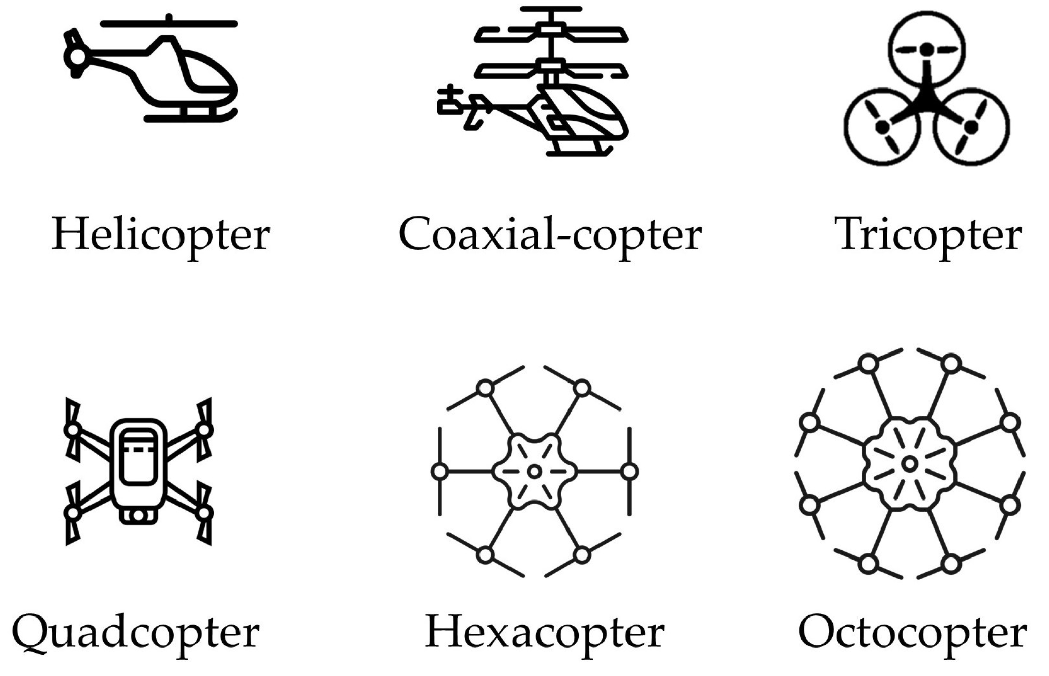
2. Types of Quadcopters
- Quadcopters support heavier payloads by generating a higher lift force through increased thrust from its rotors. The increased lift helps balance the extra weight, allowing quadcopters to stay stable and fly properly while carrying heavier loads;
- Hovering is a key feature that allows quadcopters to maintain a stable position in the air without moving. This capability is achieved when the four rotors generate thrust equal to the gravitational force acting on the quadcopter;
- Quadcopters have a simple body structure, which allows for ease of control and modelling. As a result, users can easily customize and optimize their quadcopters for various applications, enhancing overall performance;
- Quadcopters are easy to assemble. This user-friendly assembly process not only reduces setup time but also allows users to easily upgrade or replace parts, enhancing the quadcopters’ adaptability for various applications;
- Quadcopters are defined by their compact design, which not only makes them easy to transport but also enhances their versatility for use in a wide range of environments;
- Quadcopters are simple to control, allowing users to operate them with minimal training, which makes them accessible for a variety of applications;
- Quadcopters possess high maneuverability, enabling them to execute precise movements with ease. This capability arises from their rotors configuration, which allows for the independent control of each rotor’s speed and thrust, facilitating navigation through tight and complex spaces;
- Quadcopters do not require runways for operation due to their Vertical Take-Off and Landing (VTOL) capabilities. This feature allows them to ascend and descend vertically, making them suitable for use in a variety of environments;
- Quadcopters are designed for easy pre-flight setup, allowing users to prepare them for flight quickly and efficiently;
- Quadcopters are lower in cost compared to other types of UAVs, making them more accessible to a wider range of users.
2.1. Commercial Quadcopters
2.1.1. 3DR Iris+
2.1.2. DJI Phantom 3 Standard

| Type | Weight | Battery | Maximum Flight Time | Maximum Speed | Camera | Release Year | Reference |
|---|---|---|---|---|---|---|---|
| 3DR Iris+ | 1282 g (including battery) | 5100 mAh LiPo 3S | 16 min to 22 min | 11 m/s | GoPro camera | 2014 | [49] |
| DJI Phantom 3 Standard | 1216 g (including battery and propellers) | 4480 mAh LiPo 4S | 25 min | 16 m/s | 12 MP camera capturing 2.7K videos at 24/25/30 fps | 2015 | [50] |
| DJI Matrice 100 | 2355 g (including TB47D battery) or 2431 g (including TB48D battery) | TB47D 4500 mAh LiPo 6S or TB48D 5700 mAh LiPo 6S | 13 min to 40 min | 22 m/s | Not applicable | 2015 | [51] |
| DJI Inspire 1 Pro | 2870 g (including propellers and battery) | 4500 mAh LiPo 6S | 15 min | 18 m/s | 16 MP camera capturing 4K videos at 24/25/30 fps | 2016 | [52] |
| DJI Phantom 4 | 1380 g (including battery and propellers) | 5350 mAh LiPo 4S | 28 min | 20 m/s | 12.4 MP camera capturing 4K video at 24/25/30 fps | 2016 | [53] |
| DJI Matrice 210 | 3840 g (including two TB50 batteries) or 4570 g (including two TB55 batteries) | Two TB50 4280 mAh LiPo 6S or two TB55 7660 mAh LiPo 6S | 13 min to 27 min (with TB50) or 24 min to 38 min (with TB55) | 23 m/s | Supports: Zenmuse X4S, Zenmuse X5S, Zenmuse Z30, Zenmuse XT, Zenmuse XT2, SLANTRANGE 3PX, and Sentera AGX710 | 2017 | [54] |
| DJI Mavic 2 Pro | 907 g | 3850 mAh LiPo 4S | 31 min | 20 m/s | 20 MP camera capturing 4K videos at 24/25/30 fps | 2018 | [55] |

2.1.3. DJI Matrice 100
2.1.4. DJI Inspire 1 Pro
2.1.5. DJI Phantom 4
2.1.6. DJI Matrice 210
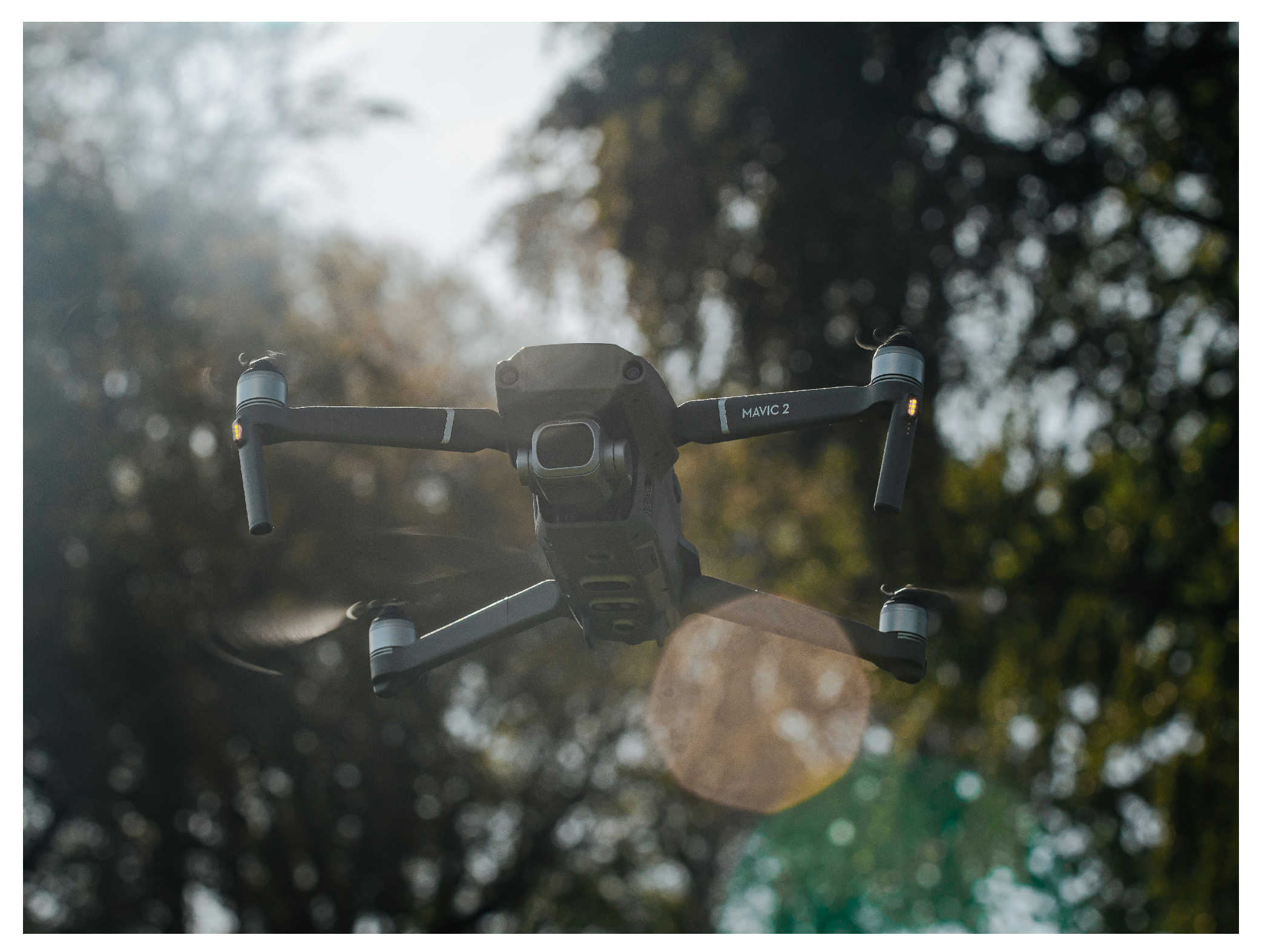
2.1.7. DJI Mavic 2 Pro
2.2. Custom-Built Quadcopters
| Quadcopter Description | University or Organization | Year | Agricultural Mission | References |
|---|---|---|---|---|
| Quadcopter built from Scarab Recon frame | University of Southern Queensland, Toowoomba, Australia | 2016 | Detecting water in furrow irrigation for better water management in a cotton field | [96] |
| Agriculture Aid to Seed Cultivation (AASC) quadcopter built with a seed planting unit | Amity University Uttar Pradesh, Noida, India | 2016 | Planting seeds in uncultivated and inaccessible areas for better field cultivation | [97] |
| Quadcopter equipped with an Arduino Uno board | BMS College of Engineering, Bengaluru, India | 2018 | Identifying irrigated areas in a farmland and determining irrigation levels | [98] |
| Quadcopter with an aluminum metal frame and a spraying mechanism | Vignans Foundation for Science Technology and Research, Guntur, Andhra Pradesh | 2019 | Designing a quadcopter for semi-autonomous pesticide spraying in smart agriculture | [99] |
| Quadcopter equipped with a seed canister system | Drone Research Initiative for Environmental Project, Indonesia | 2019 | Development of a quadcopter for dropping Tamarindus indica seeds for aerial revegetation | [100] |
| Quadcopter equipped with a seed container and seed-dispersing mechanism | Kumaraguru College of Technology, Coimbatore, India | 2020 | Designing a quadcopter for seed sowing in forests and roadside areas | [101] |
| Quadcopter equipped with a smart herbicide sprayer | University of Johannesburg, Johannesburg, South Africa | 2021 | Detecting weeds in farmland and spraying herbicides based on the weed type | [102] |
| Two carbon-fiber quadcopters: UAV-L and UAV-R | South China Agricultural University, Guangzhou, China | 2022 | Quality evaluation of close formation spraying in smart agriculture | [103] |
| Quadcopter equipped with a pneumatic seed-planting mechanism | University of KwaZulu-Natal Durban, South Africa | 2022 | Dispensing seedpods at different planting depths and spacing | [104] |
| Quadcopter with two landing gears and an Orange-Cyan-NearInfrared camera | Universitas Kristen Maranatha Bandung, Indonesia | 2023 | Capturing aerial images in a rice field and analyzing the obtained data for improved precision agriculture | [105] |

3. Agricultural Applications of Quadcopters
3.1. Chemical Spraying
3.2. Irrigation
3.3. Crop Mapping and Monitoring
3.4. Planting and Seeding
3.5. Plant Health Assessment
- DJI Phantom 4:
- -
- It was used in [76] to take multispectral images and assess the health status of olive trees by evaluating different parameters such as nutritional values, biometric features, and vegetative status.
- -
- It was employed in [77] to assess soil health by counting rice plants in an agricultural area in Tando Adam, Sindh, Pakistan.
- -
- It was selected in [78] to capture multispectral images and identify banana areas infected with Panama disease, specifically “Fusarium wilt”. This monitoring enables early treatment and improvements in planting methods.
- -
- Its Pro version was implemented in [79] to capture high-resolution images to monitor the health of Eucalyptus pellita, detecting any infestations from pests and viruses.
- -
- The authors in [80] used it to demonstrate that aerial images can serve as a cost-effective alternative to traditional field measurements for assessing citrus diseases such as Huanglongbing and Phytophthora, leading to improved crop production management.
- Co-Axial Quadcopter: it was implemeted in [113] to show how multispectral images can assist satellite data in detecting stress in trees and monitoring forest health.
- DJI Matrice 100: it was paired in [62] with a camera to capture multi-band images for detecting orchard apple trees and evaluating vegetation parameters for better health assessment.
- DJI Inspire 2: it was selected in [114] to evaluate plant vegetation and rice crop damage, resulting in improved crop monitoring.
- DJI Phantom 3 Standard: two of these drones were used in [115] to take multispectral images to assess the health of Capsicum annuum crops for better field productivity.
- UX4: it was implemeted in [116] to capture hyperspectral images to identify trees affected by citrus gummosis, the predominant fungal disease in Brazil, facilitating more effective management of plant health.
4. Modelling of Quadcopters
4.1. Configurations
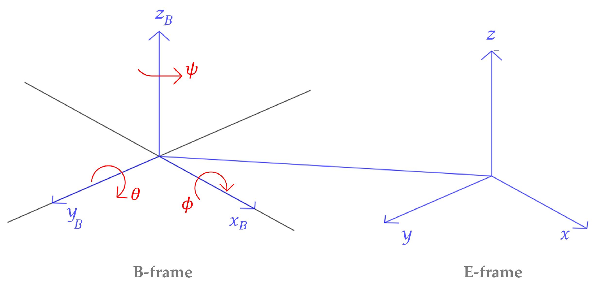
4.2. Reference Frames
4.3. Movements
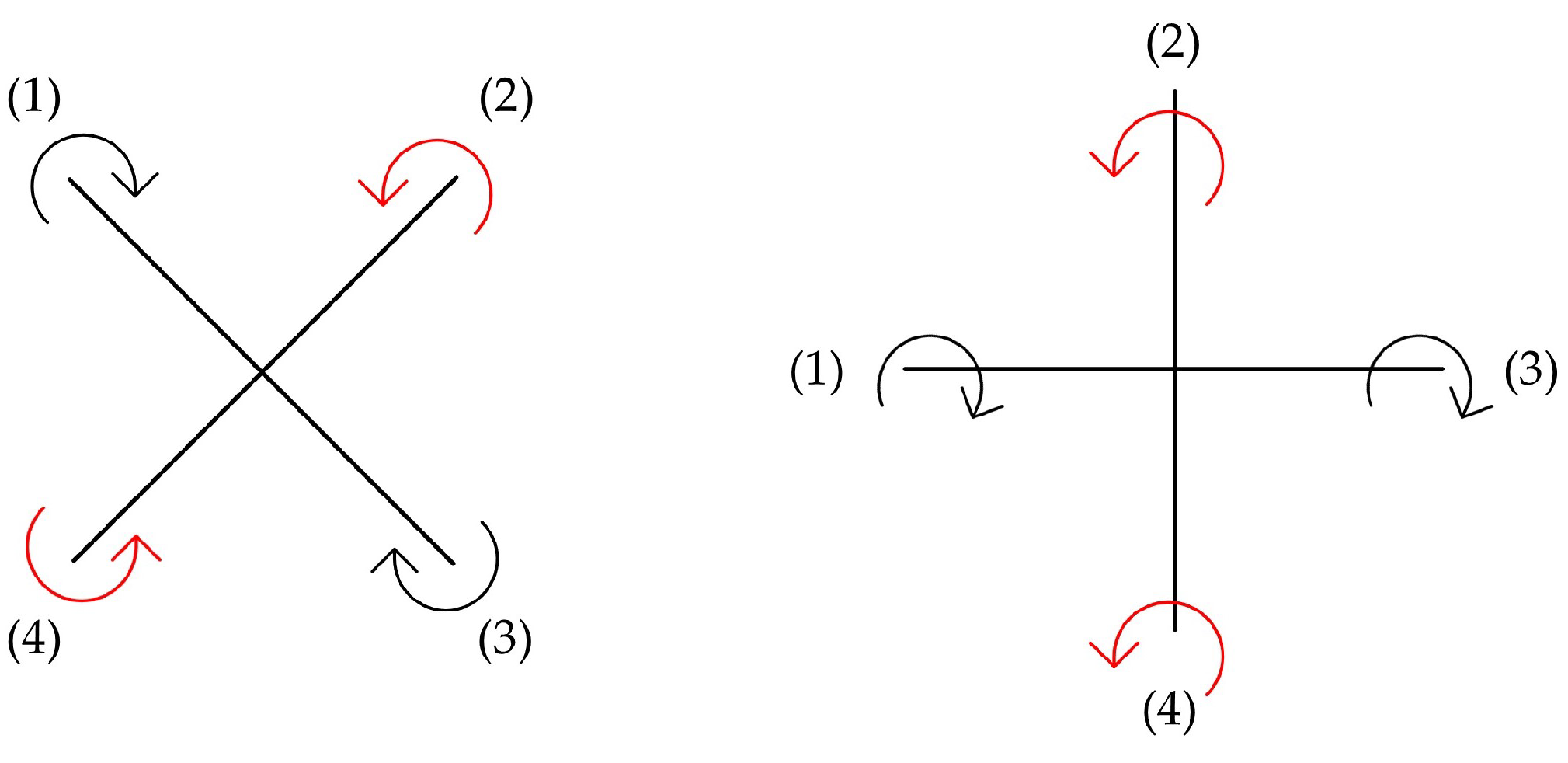
- Thrust: this movement occurs when all the rotor speeds are decreased or increased by the same value, causing the quadcopter to raise or lower its altitude;
- Roll: This movement occurs when increasing the speed of rotor 1 and decreasing the speed of rotor 3 or vice versa, while keeping rotors 2 and 4 at the same speeds. This creates a torque around the x-axis with respect to the B-frame, as shown in Figure 11, causing the quadcopter to roll;
- Pitch: This movement occurs when increasing the speed of rotor 4 and decreasing the speed of rotor 2 or vice versa, while keeping rotors 1 and 3 at the same speeds. This generates a torque around the y-axis with respect to the B-frame, as shown in Figure 11, causing the quadcopter to pitch;
- Yaw: This movement occurs by increasing the speed of rotors 2 and 4 and decreasing the speed of rotors 1 and 3 or vice versa. This creates a torque around the z-axis with respect to the B-frame, as shown in Figure 11, causing the quadcopter to yaw.
4.4. Universal Assumptions
- The quadcopter’s body structure is considered rigid;
- The quadcopter’s body frame is symmetric, leading to a diagonal inertia matrix;
- The drag and thrust factors are proportional to the square of the rotors’ speeds;
- The center of gravity and the quadcopter’s body mass are considered unified. However, this assumption might be affected by the load distribution on the quadcopter; therefore, the load should be distributed symmetrically;
- The quadcopter’s principal body axes and body frame are aligned.
4.5. Motion Equations
4.5.1. Kinematics
4.5.2. Dynamics
4.5.3. Aerodynamics
- Gyroscopic torque: it affects only the angular terms and can be generated when the roll or pitch values are non-zero. Additionally, it is produced when the propellers rotate, with one pair rotating clockwise and the other pair rotating counter-clockwise. Consequently, if the total speed of propellers is non-zero, an imbalance will occur [120,126,127,129,131,132,133,134,135,138,142,143];
- Forces and torques: they are generated by the quadcopter’s movements, as mentioned in Section 4.3, where drag and thrust factors are also included in their corresponding equations. Additionally, quadcopters may face different external disturbances, such as wind, which can cause a blade-flapping effect that affects the motor force equations. This flapping effect can be categorized into two types: low-amplitude, known as Vortex Ring State (VRS), and high-amplitude, known as Turbulence Wake State (TWS). These fluctuations can be attenuated by increasing the quadcopter’s horizontal speed [31,32,117,120,126,129,130,131,132,133,134,135,136,138,139,142,143].
5. Challenges and Future Directions
5.1. Consumption of Resources
5.1.1. Challenges
5.1.2. Future Directions
5.2. Data Processing
5.2.1. Challenges
5.2.2. Future Directions
5.3. Environmental Factors and Dynamic Obstacles
5.3.1. Challenges
5.3.2. Future Directions
5.4. Security Threats
5.4.1. Challenges
5.4.2. Future Directions
6. Conclusions
Author Contributions
Funding
Institutional Review Board Statement
Data Availability Statement
Conflicts of Interest
Appendix A
| Objective | Agricultural Mission | Limitations | Suggestions | Reference |
|---|---|---|---|---|
| Development of a high-accuracy machine-learning system with high computational speed for distinguishing between spray and non-spray areas in UAV-based spraying applications | Chemical spraying | The proposed machine learning system had limitations in identifying sprayed and non-sprayed areas in the complex canopies of crop fields. |
| [48] |
| Development of an automated machine vision algorithm for processing thermal imagery captured by UAV over a cotton field to monitor the progress of furrow irrigation across large field areas | Irrigation | False-positive readings in darkened areas of the image, a lower accuracy of water detection in images taken at higher altitudes, and camera performance affected by wind. |
| [96] |
| Creating regional-scale crop maps by utilizing both satellite and UAV-based ground truth data | Crop mapping and monitoring | Limited site selection where UAV may have difficulty flying at certain elevations and slope, lower accuracy in intercropping or mixed lands, and limited training data size |
| [63] |
| Designing a seed-sowing UAV system with payload calculation for tree planting | Planting and seeding | Reliable communication is needed to ensure a continuous link between the UAV and ground station. Static waypoints are adopted, which can cause the system to be affected by dynamic conditions. Environmental challenges, such as obstacles or weather conditions, may also impact the UAV. |
| [101] |
| Detecting pests and diseases through images of canopy foliage captured by UAV for early health monitoring of Eucalyptus pellita plantation | Plant health assessment | The 30 min UAV flight duration used in this study may limit its applicability to larger field areas. Also, the proposed algorithm was not reliable for detecting trees with smaller crown sizes and faced difficulties in densely planted areas. |
| [79] |
References
- Rehman, A.; Saba, T.; Kashif, M.; Fati, S.M.; Bahaj, S.A.; Chaudhry, H. A revisit of internet of things technologies for monitoring and control strategies in smart agriculture. Agronomy 2022, 12, 127. [Google Scholar] [CrossRef]
- Delavarpour, N.; Koparan, C.; Nowatzki, J.; Bajwa, S.; Sun, X. A technical study on UAV characteristics for precision agriculture applications and associated practical challenges. Remote Sens. 2021, 13, 1204. [Google Scholar] [CrossRef]
- Eicher, C.K.; Staatz, J.M. International Agricultural Development; JHU Press: Baltimore, MA, USA, 1998. [Google Scholar]
- Karam, K.; Mansour, A.; Khaldi, M.; Clement, B.; Ammad, M. A Survey for Unmanned Aerial Vehicles in Smart Agriculture: Types and Modelling Perspectives. In Proceedings of the 2024 IEEE 7th Advanced Information Technology, Electronic and Automation Control Conference (IAEAC), Chongqing, China, 15–17 March 2024; pp. 807–818. [Google Scholar]
- Darwin, B.; Dharmaraj, P.; Prince, S.; Popescu, D.E.; Hemanth, D.J. Recognition of bloom/yield in crop images using deep learning models for smart agriculture: A review. Agronomy 2021, 11, 646. [Google Scholar] [CrossRef]
- Martinho, V.J.P.D.; Guine, R.d.P.F. Integrated-smart agriculture: Contexts and assumptions for a broader concept. Agronomy 2021, 11, 1568. [Google Scholar] [CrossRef]
- Ciruela-Lorenzo, A.M.; Del-Aguila-Obra, A.R.; Padilla-Meléndez, A.; Plaza-Angulo, J.J. Digitalization of agri-cooperatives in the smart agriculture context. proposal of a digital diagnosis tool. Sustainability 2020, 12, 1325. [Google Scholar] [CrossRef]
- Haseeb, K.; Ud Din, I.; Almogren, A.; Islam, N. An energy efficient and secure IoT-based WSN framework: An application to smart agriculture. Sensors 2020, 20, 2081. [Google Scholar] [CrossRef]
- Quy, V.K.; Hau, N.V.; Anh, D.V.; Quy, N.M.; Ban, N.T.; Lanza, S.; Randazzo, G.; Muzirafuti, A. IoT-enabled smart agriculture: Architecture, applications, and challenges. Appl. Sci. 2022, 12, 3396. [Google Scholar] [CrossRef]
- Ayaz, M.; Ammad-Uddin, M.; Sharif, Z.; Mansour, A.; Aggoune, E.H.M. Internet-of-Things (IoT)-based smart agriculture: Toward making the fields talk. IEEE Access 2019, 7, 129551–129583. [Google Scholar] [CrossRef]
- Almalki, F.A.; Soufiene, B.O.; Alsamhi, S.H.; Sakli, H. A low-cost platform for environmental smart farming monitoring system based on IoT and UAVs. Sustainability 2021, 13, 5908. [Google Scholar] [CrossRef]
- Islam, N.; Rashid, M.M.; Pasandideh, F.; Ray, B.; Moore, S.; Kadel, R. A review of applications and communication technologies for internet of things (Iot) and unmanned aerial vehicle (uav) based sustainable smart farming. Sustainability 2021, 13, 1821. [Google Scholar] [CrossRef]
- Tsouros, D.C.; Bibi, S.; Sarigiannidis, P.G. A review on UAV-based applications for precision agriculture. Information 2019, 10, 349. [Google Scholar] [CrossRef]
- Popescu, D.; Stoican, F.; Stamatescu, G.; Ichim, L.; Dragana, C. Advanced UAV–WSN system for intelligent monitoring in precision agriculture. Sensors 2020, 20, 817. [Google Scholar] [CrossRef] [PubMed]
- Ghazbi, S.N.; Aghli, Y.; Alimohammadi, M.; Akbari, A.A. Quadrotors unmanned aerial vehicles: A review. Int. J. Smart Sens. Intell. Syst. 2016, 9, 309–333. [Google Scholar] [CrossRef]
- Sarris, Z.; Atlas, S. Survey of UAV applications in civil markets. In Proceedings of the IEEE Mediterranean Conference on Control and Automation, Dubrovnik, Croatia, 27–29 June 2001; p. 11. [Google Scholar]
- Gupte, S.; Mohandas, P.I.T.; Conrad, J.M. A survey of quadrotor unmanned aerial vehicles. In Proceedings of the 2012 IEEE Southeastcon, Orlando, FL, USA, 15–18 March 2012; pp. 1–6. [Google Scholar]
- Gupta, S.G.; Ghonge, D.M.; Jawandhiya, P.M. Review of unmanned aircraft system (UAS). Int. J. Adv. Res. Comput. Eng. Technol. (IJARCET) 2013, 2, 1646–1658. [Google Scholar] [CrossRef]
- Shraim, H.; Awada, A.; Youness, R. A survey on quadrotors: Configurations, modeling and identification, control, collision avoidance, fault diagnosis and tolerant control. IEEE Aerosp. Electron. Syst. Mag. 2018, 33, 14–33. [Google Scholar] [CrossRef]
- Lv, F.; He, W.; Zhao, L. An improved nonlinear multibody dynamic model for a parafoil-UAV system. IEEE Access 2019, 7, 139994–140009. [Google Scholar] [CrossRef]
- Tanaka, M.; Tanaka, K.; Wang, H.O. Practical model construction and stable control of an unmanned aerial vehicle with a parafoil-type wing. IEEE Trans. Syst. Man Cybern. Syst. 2017, 49, 1291–1297. [Google Scholar] [CrossRef]
- Liu, Z.; Wang, X.; Shen, L.; Zhao, S.; Cong, Y.; Li, J.; Yin, D.; Jia, S.; Xiang, X. Mission-oriented miniature fixed-wing UAV swarms: A multilayered and distributed architecture. IEEE Trans. Syst. Man Cybern. Syst. 2020, 52, 1588–1602. [Google Scholar] [CrossRef]
- Velusamy, P.; Rajendran, S.; Mahendran, R.K.; Naseer, S.; Shafiq, M.; Choi, J.G. Unmanned Aerial Vehicles (UAV) in precision agriculture: Applications and challenges. Energies 2021, 15, 217. [Google Scholar] [CrossRef]
- Shakhatreh, H.; Sawalmeh, A.H.; Al-Fuqaha, A.; Dou, Z.; Almaita, E.; Khalil, I.; Othman, N.S.; Khreishah, A.; Guizani, M. Unmanned aerial vehicles (UAVs): A survey on civil applications and key research challenges. IEEE Access 2019, 7, 48572–48634. [Google Scholar] [CrossRef]
- Tripathi, V.K.; Kamath, A.K.; Behera, L.; Verma, N.K.; Nahavandi, S. An adaptive fast terminal sliding-mode controller with power rate proportional reaching law for quadrotor position and altitude tracking. IEEE Trans. Syst. Man Cybern. Syst. 2021, 52, 3612–3625. [Google Scholar] [CrossRef]
- Xiong, J.J.; Guo, N.H.; Mao, J.; Wang, H.D. Self-tuning sliding mode control for an uncertain coaxial octorotor UAV. IEEE Trans. Syst. Man Cybern. Syst. 2022, 53, 1160–1171. [Google Scholar] [CrossRef]
- Yuan, H.; Yang, J.; Jiang, X.; Zhu, Y.; Cao, W.; Ni, J. Design and testing of a crop growth sensor aboard a fixed-wing unmanned aerial vehicle. Comput. Electron. Agric. 2022, 194, 106762. [Google Scholar] [CrossRef]
- Hakim, M.; Pratiwi, H.; Nugraha, A.; Yatmono, S.; Wardhana, A.; Damarwan, E.; Agustianto, T.; Noperi, S. Development of unmanned aerial vehicle (UAV) fixed-wing for monitoring, mapping and dropping applications on agricultural land. J. Phys. Conf. Ser. 2021, 2111, 012051. [Google Scholar] [CrossRef]
- Ammad-Udin, M.; Mansour, A.; Le Jeune, D.; Aggoune, E.H.M.; Ayaz, M. UAV routing protocol for crop health management. In Proceedings of the 2016 24th European signal processing conference (EUSIPCO), Budapest, Hungary, 29 August–2 September 2016; pp. 1818–1822. [Google Scholar]
- Ammad Uddin, M.; Mansour, A.; Le Jeune, D.; Ayaz, M.; Aggoune, E.H.M. UAV-assisted dynamic clustering of wireless sensor networks for crop health monitoring. Sensors 2018, 18, 555. [Google Scholar] [CrossRef]
- Matouk, D.; Ahmad, F.; Kumar, P.; Merzouki, R.; Singh, M.; Abdessemed, F. Bond Graph Model-Based Control of the Quadcopter Dynamics. In Proceedings of the 2018 7th International Conference on Systems and Control (ICSC), Valencia, Spain, 24–26 October 2018; pp. 435–440. [Google Scholar]
- Elruby, A.Y.; El-Khatib, M.; El-Amary, N.H.; Hashad, A. Dynamic modeling and control of quadrotor vehicle. In Proceedings of the The International Conference on Applied Mechanics and Mechanical Engineering. Military Technical College, Cairo, Egypt, 29–31 May 2012; Volume 15, pp. 1–10. [Google Scholar]
- Santoso, F.; Garratt, M.A.; Anavatti, S.G. Hybrid PD-fuzzy and PD controllers for trajectory tracking of a quadrotor unmanned aerial vehicle: Autopilot designs and real-time flight tests. IEEE Trans. Syst. Man Cybern. Syst. 2019, 51, 1817–1829. [Google Scholar] [CrossRef]
- Ouyang, Y.; Xue, L.; Dong, L.; Sun, C. Neural network-based finite-time distributed formation-containment control of two-layer quadrotor UAVs. IEEE Trans. Syst. Man Cybern. Syst. 2021, 52, 4836–4848. [Google Scholar] [CrossRef]
- Budnyaev, V.A.; Filippov, I.F.; Vertegel, V.V.; Dudnikov, S.Y. Simulink-based quadcopter control system model. In Proceedings of the 2020 1st International Conference Problems of Informatics, Electronics, and Radio Engineering (PIERE), Novosibirsk, Russia, 10–11 December 2020; pp. 246–250. [Google Scholar]
- Agriculture Drones Market. Available online: https://www.fortunebusinessinsights.com/agriculture-drones-market-102589 (accessed on 1 August 2024).
- Agriculture Drones Market. Available online: https://www.marketsandmarkets.com/Market-Reports/agriculture-drones-market-23709764.html (accessed on 1 August 2024).
- Cano, E.; Horton, R.; Liljegren, C.; Bulanon, D.M. Comparison of small unmanned aerial vehicles performance using image processing. J. Imaging 2017, 3, 4. [Google Scholar] [CrossRef]
- Nintanavongsa, P.; Yaemvachi, W.; Pitimon, I. A self-sustaining unmanned aerial vehicle routing protocol for smart farming. In Proceedings of the 2016 International Symposium on Intelligent Signal Processing and Communication Systems (ISPACS), Phuket, Thailand, 24–27 October 2016; pp. 1–5. [Google Scholar]
- Alzate, D.F.; Fajardo, A.E.; Santa, J.D.; Álvarez, J.; Alarcón, A.; Soto-Suárez, M. NDVI index and K-means clustering in multispectral images to calculate the severity of affectation by Phytophtora infestans in potato crops. In Proceedings of the DAAD Alumni Seminar 2017, Hue, Vietnam, 24 September–1 October 2017; p. 108. [Google Scholar]
- Φραγκoυλóπoυλoς, E.G. Agricultural Robotics and Automation Robot Collaboration for Precision Agriculture. Ph.D. Thesis, University of Thessaly, Volos, Greece, 2017. [Google Scholar]
- Hovhannisyan, T.; Efendyan, P.; Vardanyan, M. Creation of a digital model of fields with application of DJI phantom 3 drone and the opportunities of its utilization in agriculture. Ann. Agrar. Sci. 2018, 16, 177–180. [Google Scholar] [CrossRef]
- Holtorf, L.; Titov, I.; Daschner, F.; Gerken, M. UAV-based Wireless data collection from underground sensor nodes for precision agriculture. AgriEngineering 2023, 5, 338–354. [Google Scholar] [CrossRef]
- Bulanon, D.M.; Fallahi, E. A Smart Vision System for Monitoring Specialty Crops. In Proceedings of the Future Technologies Conference (FTC) 2017, Vancouver, BC, Canada, 29–30 November 2017. [Google Scholar]
- Rao, A.; Shao, H.; Yang, X. The design and implementation of smart agricultural management platform based on UAV and wireless sensor network. In Proceedings of the 2019 IEEE 2nd International Conference on Electronics Technology (ICET), Chengdu, China, 10–13 May 2019; pp. 248–252. [Google Scholar]
- Ghimire, S. Monitoring Crop Health Growth and Its Stand Count Attributes Using UAV Based Precision Agriculture: A Study in Tropical Farmland of Thailand. Ph.D. Thesis, Thammasat University, Bangkok, Thailand, 2017. [Google Scholar]
- Psirofonia, P.; Samaritakis, V.; Eliopoulos, P.; Potamitis, I. Use of unmanned aerial vehicles for agricultural applications with emphasis on crop protection: Three novel case-studies. Int. J. Agric. Sci. Technol. 2017, 5, 30–39. [Google Scholar] [CrossRef]
- Gao, P.; Zhang, Y.; Zhang, L.; Noguchi, R.; Ahamed, T. Development of a recognition system for spraying areas from unmanned aerial vehicles using a machine learning approach. Sensors 2019, 19, 313. [Google Scholar] [CrossRef] [PubMed]
- 3D Robotics, Inc. IRIS+ Operation Manual. 2014. Available online: https://www.manualslib.com/manual/855670/3dr-IrisPlus.html?page=2#manual (accessed on 20 August 2024).
- DJI Technology Co., Ltd. Phantom 3 Standard User Manual v1.4. 2017. Available online: https://dl.djicdn.com/downloads/phantom_3/User%20Manual/Phantom_3_Standard_User_Manual_v1.4_en.pdf (accessed on 20 August 2024).
- DJI Technology Co., Ltd. DJI Matrice 100 User Manual v1.6. 2016. Available online: https://dl.djicdn.com/downloads/m100/M100_User_Manual_EN.pdf (accessed on 20 August 2024).
- DJI Technology Co., Ltd. DJI Inspire 1 Pro User Manual v1.4. 2017. Available online: https://dl.djicdn.com/downloads/INSPIRE%201%20series/20201123/INSPIRE_1_PRO_User_Manual_20201123.pdf (accessed on 20 August 2024).
- DJI Technology Co., Ltd. Phantom 4 User Manual v1.6. 2017. Available online: https://dl.djicdn.com/downloads/phantom_4/20170706/Phantom_4_User_Manual_v1.6.pdf (accessed on 20 August 2024).
- DJI Technology Co., Ltd. DJI Matrice 200 Series User Manual v1.4. 2018. Available online: https://dl.djicdn.com/downloads/M200/20201120/Matrice_210_210_RTK_User_Manual_EN_20201120.pdf (accessed on 20 August 2024).
- DJI Technology Co., Ltd. DJI Mavic 2 PRO/ZOOM User Manual v2.2. 2020. Available online: https://dl.djicdn.com/downloads/Mavic_2/Mavic_2_Pro_Zoom_User_Manual_v2.2_en.pdf (accessed on 20 August 2024).
- Bradford, C. Unsplash. Available online: https://unsplash.com/photos/dji-phantom-drone-flying-midair-l1Zt6OyfNfo (accessed on 1 August 2024).
- Su, J.; Yi, D.; Su, B.; Mi, Z.; Liu, C.; Hu, X.; Xu, X.; Guo, L.; Chen, W.H. Aerial visual perception in smart farming: Field study of wheat yellow rust monitoring. IEEE Trans. Ind. Inform. 2020, 17, 2242–2249. [Google Scholar] [CrossRef]
- Der Yang, M.; Tseng, H.H.; Hsu, Y.C.; Tseng, W.C. Real-time crop classification using edge computing and deep learning. In Proceedings of the 2020 IEEE 17th Annual Consumer Communications & Networking Conference (CCNC), Las Vegas, NV, USA, 10–13 January 2020; pp. 1–4. [Google Scholar]
- Bento, N.L.; Ferraz, G.A.e.S.; Amorim, J.d.S.; Santana, L.S.; Barata, R.A.P.; Soares, D.V.; Ferraz, P.F.P. Weed detection and mapping of a coffee farm by a remotely piloted aircraft system. Agronomy 2023, 13, 830. [Google Scholar] [CrossRef]
- Christiansen, M.P.; Laursen, M.S.; Jørgensen, R.N.; Skovsen, S.; Gislum, R. Designing and testing a UAV mapping system for agricultural field surveying. Sensors 2017, 17, 2703. [Google Scholar] [CrossRef]
- Yeom, J.; Jung, J.; Chang, A.; Ashapure, A.; Maeda, M.; Maeda, A.; Landivar, J. Comparison of vegetation indices derived from UAV data for differentiation of tillage effects in agriculture. Remote Sens. 2019, 11, 1548. [Google Scholar] [CrossRef]
- Jemaa, H.; Bouachir, W.; Leblon, B.; LaRocque, A.; Haddadi, A.; Bouguila, N. UAV -based computer vision system for orchard apple tree detection and health assessment. Remote Sens. 2023, 15, 3558. [Google Scholar] [CrossRef]
- Hegarty-Craver, M.; Polly, J.; O’Neil, M.; Ujeneza, N.; Rineer, J.; Beach, R.H.; Lapidus, D.; Temple, D.S. Remote crop mapping at scale: Using satellite imagery and UAV-acquired data as ground truth. Remote Sens. 2020, 12, 1984. [Google Scholar] [CrossRef]
- Kumar, A.; Shreeshan, S.; Tejasri, N.; Rajalakshmi, P.; Guo, W.; Naik, B.; Marathi, B.; Desai, U. Identification of water-stressed area in maize crop using uav based remote sensing. In Proceedings of the 2020 IEEE India geoscience and remote sensing symposium (InGARSS), Ahmedabad, India, 1–4 December 2020; pp. 146–149. [Google Scholar]
- Tejasri, N.; Pachamuthu, R.; Naik, B.; Desai, U.B. Intelligent drought stress monitoring on spatio-spectral-temporal drone based crop imagery using deep networks. In Proceedings of the 2nd AAAI Workshop on AI for Agriculture and Food Systems, Washington, DC, USA, 13 February 2023. [Google Scholar]
- McGhee, S. Unsplash. Available online: https://unsplash.com/photos/quadcopter-drone-flying-in-mid-air-during-daytime-UC5FpqofFOk (accessed on 1 August 2024).
- Nhamo, L.; Van Dijk, R.; Magidi, J.; Wiberg, D.; Tshikolomo, K. Improving the accuracy of remotely sensed irrigated areas using post-classification enhancement through UAV capability. Remote Sens. 2018, 10, 712. [Google Scholar] [CrossRef]
- Yang, C.Y.; Yang, M.D.; Tseng, W.C.; Hsu, Y.C.; Li, G.S.; Lai, M.H.; Wu, D.H.; Lu, H.Y. Assessment of rice developmental stage using time series UAV imagery for variable irrigation management. Sensors 2020, 20, 5354. [Google Scholar] [CrossRef]
- Risal, A.; Niu, H.; Landivar-Scott, J.L.; Maeda, M.M.; Bednarz, C.W.; Landivar-Bowles, J.; Duffield, N.; Payton, P.; Pal, P.; Lascano, R.J.; et al. Improving Irrigation Management of Cotton with Small Unmanned Aerial Vehicle (UAV) in Texas High Plains. Water 2024, 16, 1300. [Google Scholar] [CrossRef]
- Li, X.; Ba, Y.; Zhang, M.; Nong, M.; Yang, C.; Zhang, S. Sugarcane nitrogen concentration and irrigation level prediction based on UAV multispectral imagery. Sensors 2022, 22, 2711. [Google Scholar] [CrossRef] [PubMed]
- Bannari, A.; Selouani, A.; El-Basri, M.; Rhinane, H.; El-Harti, A.; El-Ghmari, A. Multi-scale analysis of DEMS derived from unmanned aerial vehicle (UAV) in precision agriculture context. In Proceedings of the 2021 IEEE International Geoscience and Remote Sensing Symposium IGARSS, Brussels, Belgium, 11–16 July 2021; pp. 8285–8288. [Google Scholar]
- Lottes, P.; Khanna, R.; Pfeifer, J.; Siegwart, R.; Stachniss, C. UAV-based crop and weed classification for smart farming. In Proceedings of the 2017 IEEE international conference on robotics and automation (ICRA), Singapore, 29 May–3 June 2017; pp. 3024–3031. [Google Scholar]
- Brook, A.; De Micco, V.; Battipaglia, G.; Erbaggio, A.; Ludeno, G.; Catapano, I.; Bonfante, A. A smart multiple spatial and temporal resolution system to support precision agriculture from satellite images: Proof of concept on Aglianico vineyard. Remote Sens. Environ. 2020, 240, 111679. [Google Scholar] [CrossRef]
- Jonak, M.; Mucha, J.; Jezek, S.; Kovac, D.; Cziria, K. SPAGRI-AI: Smart precision agriculture dataset of aerial images at different heights for crop and weed detection using super-resolution. Agric. Syst. 2024, 216, 103876. [Google Scholar] [CrossRef]
- Tagarakis, A.C.; Filippou, E.; Kalaitzidis, D.; Benos, L.; Busato, P.; Bochtis, D. Proposing UGV and UAV systems for 3D mapping of orchard environments. Sensors 2022, 22, 1571. [Google Scholar] [CrossRef] [PubMed]
- Catania, P.; Roma, E.; Orlando, S.; Vallone, M. Evaluation of Multispectral Data Acquired from UAV Platform in Olive Orchard. Horticulturae 2023, 9, 133. [Google Scholar] [CrossRef]
- Hassan, S.I.; Alam, M.M.; Zia, M.Y.I.; Rashid, M.; Illahi, U.; Su’ud, M.M. Rice crop counting using aerial imagery and GIS for the assessment of soil health to increase crop yield. Sensors 2022, 22, 8567. [Google Scholar] [CrossRef]
- Ye, H.; Huang, W.; Huang, S.; Cui, B.; Dong, Y.; Guo, A.; Ren, Y.; Jin, Y. Recognition of banana fusarium wilt based on UAV remote sensing. Remote Sens. 2020, 12, 938. [Google Scholar] [CrossRef]
- Megat Mohamed Nazir, M.N.; Terhem, R.; Norhisham, A.R.; Mohd Razali, S.; Meder, R. Early monitoring of health status of plantation-grown eucalyptus pellita at large spatial scale via visible spectrum imaging of canopy foliage using unmanned aerial vehicles. Forests 2021, 12, 1393. [Google Scholar] [CrossRef]
- Garza, B.N.; Ancona, V.; Enciso, J.; Perotto-Baldivieso, H.L.; Kunta, M.; Simpson, C. Quantifying citrus tree health using true color UAV images. Remote Sensing 2020, 12, 170. [Google Scholar] [CrossRef]
- Freeman, B. Unsplash. Available online: https://unsplash.com/photos/white-and-red-drone-flying-during-daytime-BFqKcWMEXP4 (accessed on 1 August 2024).
- Ampatzidis, Y.; Partel, V.; Costa, L. Agroview: Cloud-based application to process, analyze and visualize UAV-collected data for precision agriculture applications utilizing artificial intelligence. Comput. Electron. Agric. 2020, 174, 105457. [Google Scholar] [CrossRef]
- Teshome, F.T.; Bayabil, H.K.; Hoogenboom, G.; Schaffer, B.; Singh, A.; Ampatzidis, Y. Unmanned aerial vehicle (UAV) imaging and machine learning applications for plant phenotyping. Comput. Electron. Agric. 2023, 212, 108064. [Google Scholar] [CrossRef]
- Lambertini, A.; Mandanici, E.; Tini, M.A.; Vittuari, L. Technical challenges for multi-temporal and multi-sensor image processing surveyed by UAV for mapping and monitoring in precision agriculture. Remote Sens. 2022, 14, 4954. [Google Scholar] [CrossRef]
- Jamil, N.; Kootstra, G.; van Apeldoorn, D.F.; Van Henten, E.J.; Kooistra, L. UAV time-series imagery show diversity treatment effects on cabbage growth. Smart Agric. Technol. 2024, 8, 100443. [Google Scholar] [CrossRef]
- Atanasov, A.; Bankova, A.; Zhecheva, G. Observation of the vegetation processes of agricultural crops using small unmanned aerial vehicles in Dobrudja region. Bulg. J. Agric. Sci. 2023, 29. [Google Scholar]
- Atanasov, A.; Bankova, A. The influence of location accuracy on the estimation of crops with a budget UAV in Dobrudja. In Proceedings of the 2024 9th International Conference on Energy Efficiency and Agricultural Engineering (EE&AE), Ruse, Bulgaria, 27–29 June 2024; pp. 1–5. [Google Scholar]
- Atanasov, A. Possibilities of small robotic UAVS for surveillance of agricultural areas in Southern Dobruja. Bulg. J. Crop. Sci. 2024, 61, 100–108. [Google Scholar] [CrossRef]
- Genze, N.; Ajekwe, R.; Güreli, Z.; Haselbeck, F.; Grieb, M.; Grimm, D.G. Deep learning-based early weed segmentation using motion blurred UAV images of sorghum fields. Comput. Electron. Agric. 2022, 202, 107388. [Google Scholar] [CrossRef]
- McCarthy, C.; Nyoni, Y.; Kachamba, D.J.; Banda, L.B.; Moyo, B.; Chisambi, C.; Banfill, J.; Hoshino, B. Can drones help smallholder farmers improve agriculture efficiencies and reduce food insecurity in Sub-Saharan Africa? Local perceptions from Malawi. Agriculture 2023, 13, 1075. [Google Scholar] [CrossRef]
- Du, X.; Huang, D.; Dai, L.; Du, X. Recognition of Plastic Film in Terrain-Fragmented Areas Based on Drone Visible Light Images. Agriculture 2024, 14, 736. [Google Scholar] [CrossRef]
- Ichim, L.; Ciciu, R.; Popescu, D. Using drones and deep neural networks to detect halyomorpha halys in ecological orchards. In Proceedings of the IGARSS 2022–2022 IEEE International Geoscience and Remote Sensing Symposium, Kuala Lumpur, Malaysia, 17–22 July 2022; pp. 437–440. [Google Scholar]
- Hobba, B.; Akıncı, S.; Göktogan, A.H. Efficient herbicide spray pattern generation for site-specific weed management practices using semantic segmentation on UAV imagery. In Proceedings of the Australasian Conference on Robotics and Automation (ACRA-2021), Online, 6–8 December 2021; pp. 1–10. [Google Scholar]
- Vellemu, E.C.; Katonda, V.; Yapuwa, H.; Msuku, G.; Nkhoma, S.; Makwakwa, C.; Safuya, K.; Maluwa, A. Using the Mavic 2 Pro drone for basic water quality assessment. Sci. Afr. 2021, 14, e00979. [Google Scholar] [CrossRef]
- Buchhave, J. Unsplash. Available online: https://unsplash.com/photos/black-and-gray-drone-with-brown-heart-shaped-heart-shaped-pendant-lj00ODz01b4 (accessed on 1 August 2024).
- Long, D.; McCarthy, C.; Jensen, T. Row and water front detection from UAV thermal-infrared imagery for furrow irrigation monitoring. In Proceedings of the 2016 IEEE International Conference on Advanced Intelligent Mechatronics (AIM), Banff, AB, Canada, 12–15 July 2016; pp. 300–305. [Google Scholar]
- Choudhury, T.; Kaur, A.; Verma, U.S. Agricultural aid to seed cultivation: An Agribot. In Proceedings of the 2016 International Conference on Computing, Communication and Automation (ICCCA), Greater Noida, India, 29–30 April 2016; pp. 993–998. [Google Scholar]
- Ajith, G.; Bharadwaj, C.N.; Naveen kumar, T.S.; Nag, T.S.; Gururaj, C. UAV aided irrigation using object detection through wireless communication technology. In Proceedings of the 2018 2nd International Conference on Trends in Electronics and Informatics (ICOEI), Tirunelveli, India, 11–12 May 2018; pp. 714–719. [Google Scholar]
- Rao, V.P.S.; Rao, G.S. Design and modelling of anaffordable uav based pesticide sprayer in agriculture applications. In Proceedings of the 2019 Fifth International Conference on Electrical Energy Systems (ICEES), Chennai, India, 21–22 February 2019; pp. 1–4. [Google Scholar]
- Andrio, A. Development of UAV technology in seed dropping for aerial revegetation practices in Indonesia. IOP Conf. Ser. Earth Environ. Sci. 2019, 308, 012051. [Google Scholar] [CrossRef]
- Yamunathangam, D.; Shanmathi, J.; Caviya, R.; Saranya, G. Payload manipulation for seed sowing unmanned aerial vehicle through interface with pixhawk flight controller. In Proceedings of the 2020 Fourth International Conference on Inventive Systems and Control (ICISC), Coimbatore, India, 8–10 January 2020; pp. 931–934. [Google Scholar]
- Ukaegbu, U.F.; Tartibu, L.K.; Okwu, M.O.; Olayode, I.O. Development of a light-weight unmanned aerial vehicle for precision agriculture. Sensors 2021, 21, 4417. [Google Scholar] [CrossRef] [PubMed]
- Chen, P.; Ouyang, F.; Zhang, Y.; Lan, Y. Preliminary evaluation of spraying quality of multi-unmanned aerial vehicle (UAV) close formation spraying. Agriculture 2022, 12, 1149. [Google Scholar] [CrossRef]
- Govender, T.; Bright, G.; Botha, I.R. Evaluating the Seed Sowing Performance of a UAV Supported Pneumatic Planting System. In Proceedings of the 2022 28th International Conference on Mechatronics and Machine Vision in Practice (M2VIP), Nanjing, China, 16–18 November 2022; pp. 1–6. [Google Scholar]
- Muliady, M.; Utama, V. Quadcopter Design and Development for Precision Agriculture Implementation in a Rice Field. In Proceedings of the 2023 1st IEEE International Conference on Smart Technology (ICE-SMARTec), Nanjing, China, 16–18 November 2022; pp. 26–31. [Google Scholar]
- Basso, M.; Stocchero, D.; Ventura Bayan Henriques, R.; Vian, A.L.; Bredemeier, C.; Konzen, A.A.; Pignaton de Freitas, E. Proposal for an embedded system architecture using a GNDVI algorithm to support UAV-based agrochemical spraying. Sensors 2019, 19, 5397. [Google Scholar] [CrossRef]
- Niu, H.; Zhao, T.; Wang, D.; Chen, Y. A UAV resolution and waveband aware path planning for onion irrigation treatments inference. In Proceedings of the 2019 International Conference on Unmanned Aircraft Systems (ICUAS), Atlanta, GA, USA, 11–14 June 2019; pp. 808–812. [Google Scholar]
- Niu, H.; Wang, D.; Chen, Y. Tree-level irrigation inference using UAV thermal imagery and convolutional neural networks. In Proceedings of the 2022 International Conference on Unmanned Aircraft Systems (ICUAS), Dubrovnik, Croatia, 21–24 June 2022; pp. 1586–1591. [Google Scholar]
- Jalajamony, H.M.; Nair, M.; Ajala, S.; Chambers, K.; Jones, D.; Battle, J.; Mead, P.F.; Fernandez, R.E. Low-cost thermal infrared aided drone for dry patch detection in an intelligent irrigation system. In Proceedings of the 2022 IEEE Sensors, Dallas, TX, USA, 30 October–2 November 2022; pp. 1–4. [Google Scholar]
- Navia, J.; Mondragon, I.; Patino, D.; Colorado, J. Multispectral mapping in agriculture: Terrain mosaic using an autonomous quadcopter UAV. In Proceedings of the 2016 International Conference on Unmanned Aircraft Systems (ICUAS), Arlington, VA, USA, 7–10 June 2016; pp. 1351–1358. [Google Scholar]
- Potena, C.; Khanna, R.; Nieto, J.; Siegwart, R.; Nardi, D.; Pretto, A. AgriColMap: Aerial-ground collaborative 3D mapping for precision farming. IEEE Robot. Autom. Lett. 2019, 4, 1085–1092. [Google Scholar] [CrossRef]
- Wu, Z.; Li, M.; Lei, X.; Wu, Z.; Jiang, C.; Zhou, L.; Ma, R.; Chen, Y. Simulation and parameter optimisation of a centrifugal rice seeding spreader for a UAV. Biosyst. Eng. 2020, 192, 275–293. [Google Scholar] [CrossRef]
- Dash, J.P.; Pearse, G.D.; Watt, M.S. UAV multispectral imagery can complement satellite data for monitoring forest health. Remote Sens. 2018, 10, 1216. [Google Scholar] [CrossRef]
- Kim, H.; Kim, W.; Kim, S.D. Damage assessment of rice crop after toluene exposure based on the vegetation index (VI) and UAV multispectral imagery. Remote Sens. 2020, 13, 25. [Google Scholar] [CrossRef]
- Sosa-Herrera, J.A.; Vallejo-Pérez, M.R.; Álvarez-Jarquín, N.; Cid-García, N.M.; López-Araujo, D.J. Geographic object-based analysis of airborne multispectral images for health assessment of Capsicum annuum L. crops. Sensors 2019, 19, 4817. [Google Scholar] [CrossRef]
- Moriya, É.A.S.; Imai, N.N.; Tommaselli, A.M.G.; Berveglieri, A.; Santos, G.H.; Soares, M.A.; Marino, M.; Reis, T.T. Detection and mapping of trees infected with citrus gummosis using UAV hyperspectral data. Comput. Electron. Agric. 2021, 188, 106298. [Google Scholar] [CrossRef]
- Musa, S. Techniques for quadcopter modeling and design: A review. J. Unmanned Syst. Technol. 2018, 5, 66–75. [Google Scholar]
- Abbasi, E.; Mahjoob, M.; Yazdanpanah, R. Controlling of quadrotor uav using a fuzzy system for tuning the pid gains in hovering mode. In Proceedings of the 10th International Conference on Advances in Computer Entertainment (ACE 2013), Boekelo, The Netherlands, 12–15 November 2013; pp. 1–6. [Google Scholar]
- Bousbaine, A.; Wu, M.H.; Poyi, G.T. Modelling and simulation of a quad-rotor helicopter. In Proceedings of the 6th IET International Conference on Power Electronics, Machines and Drives (PEMD 2012), Bristol, UK, 27–29 March 2012; pp. 1–6. [Google Scholar]
- Bresciani, T. Modelling, Identification and Control of a Quadrotor Helicopter. Master’s Thesis, Lund University, Lund, Denmark, 2008. [Google Scholar]
- Gautam, D.; Ha, C. Control of a quadrotor using a smart self-tuning fuzzy PID controller. Int. J. Adv. Robot. Syst. 2013, 10, 380. [Google Scholar] [CrossRef]
- Poyi, G.T. A Novel Approach to the Control of Quad-Rotor Helicopters Using Fuzzy-Neural Networks; University of Derby: Derby, UK, 2014. [Google Scholar]
- Deif, T.; Kassem, A.; El Baioumi, G. Modeling and attitude stabilization of indoor quad rotor. Int. Rev. Aerosp. Eng. (IREASE) 2014, 7, 43–47. [Google Scholar] [CrossRef]
- Zulu, A.; John, S. A review of control algorithms for autonomous quadrotors. arXiv 2016, arXiv:1602.02622. [Google Scholar] [CrossRef]
- Thusoo, R.; Jain, S.; Bangia, S. Quadrotors in the Present Era: A Review. Inf. Technol. Ind. 2021, 9, 164–178. [Google Scholar]
- Benić, Z.; Piljek, P.; Kotarski, D. Mathematical modelling of unmanned aerial vehicles with four rotors. Interdiscip. Descr. Complex Syst. INDECS 2016, 14, 88–100. [Google Scholar] [CrossRef]
- Miladi, N.; Ladhari, T.; Said, S.H.; M’sahli, F. Tracking control of quadcopter using explicit nonlinear model predictive control. In Proceedings of the 2018 15th International Multi-Conference on Systems, Signals & Devices (SSD), Yasmine Hammamet, Tunisia, 19–22 March 2018; pp. 995–1000. [Google Scholar]
- El Dakrory, A.M.; Tawfik, M. Utilization of neural network and the discrepancy between it and modeling in quadcopter attitude. In Proceedings of the 2016 International Workshop on Recent Advances in Robotics and Sensor Technology for Humanitarian Demining and Counter-IEDs (RST), Cairo, Egypt, 27–30 October 2016; pp. 1–6. [Google Scholar]
- De Lellis Costa de Oliveira, M. Modeling, Identification and Control of a Quadrotor Aircraft. Master’s Thesis, Czech Technical University in Prague, Prague, Czech Republic, 2011. [Google Scholar]
- Paiva, E.A.; Soto, J.C.; Salinas, J.A.; Ipanaqué, W. Modeling and PID cascade control of a Quadcopter for trajectory tracking. In Proceedings of the 2015 CHILEAN Conference on Electrical, Electronics Engineering, Information and Communication Technologies (CHILECON), Santiago, Chile, 28–30 October 2015; pp. 809–815. [Google Scholar]
- Mustapa, Z.; Saat, S.; Husin, S.; Zaid, T. Quadcopter physical parameter identification and altitude system analysis. In Proceedings of the 2014 IEEE Symposium on Industrial Electronics & Applications (ISIEA), Kota Kinabalu, Malaysia, 28 September–1 October 2014; pp. 130–135. [Google Scholar]
- Luukkonen, T. Modelling and Control of Quadcopter; Independent Research Project in Applied Mathematics; Aalto University: Espoo, Finland, 22 August 2011. [Google Scholar]
- Mie, S.; Okuyama, Y.; Saito, H. Simplified quadcopter simulation model for spike-based hardware PID controller using SystemC-AMS. In Proceedings of the 2018 IEEE 12th International Symposium on Embedded Multicore/Many-core Systems-on-Chip (MCSoC), Hanoi, Vietnam, 12–14 September 2018; pp. 23–27. [Google Scholar]
- Khadija, E.H.; Abdeljalil, E.K.; Mostafa, M.; Hassan, A. Adapting parameters for flight control of a quadcopter using reference model and fuzzy logic. In Proceedings of the 2015 Third World Conference on Complex Systems (WCCS), Marrakech, Morocco, 23–25 November 2015; pp. 1–6. [Google Scholar]
- Imane, S.; Mostafa, M.; Hassan, A.; Abdeljalil, E.K. Control of a quadcopter using reference model and genetic algorithm methods. In Proceedings of the 2015 Third World Conference on Complex Systems (WCCS), Marrakech, Morocco, 23–25 November 2015; pp. 1–6. [Google Scholar]
- Talaeizadeh, A.; Najafi, E.; Pishkenari, H.N.; Alasty, A. Deployment of model-based design approach for a mini-quadcopter. In Proceedings of the 2019 7th International Conference on Robotics and Mechatronics (ICRoM), Tehran, Iran, 20–21 November 2019; pp. 291–296. [Google Scholar]
- Ali, Q.; Montenegro, S. Explicit model following distributed control scheme for formation flying of mini UAVs. IEEE Access 2016, 4, 397–406. [Google Scholar] [CrossRef]
- Kostin, A. Models and methods for implementing the automous performance of transportation tasks using a drone. In Proceedings of the 2021 Wave Electronics and its Application in Information and Telecommunication Systems (WECONF), St. Petersburg, Russia, 31 May–4 June 2021; pp. 1–4. [Google Scholar]
- Venkatasundarakumar, T.; Suwathy, R.; Haripriya, T.; Venkatesan, M. Motion control analysis of a quadcopter system part II—Modelling. In Proceedings of the 2016 IEEE International Conference on Computational Intelligence and Computing Research (ICCIC), Chennai, India, 15–17 December 2016; pp. 1–4. [Google Scholar]
- Merabti, H.; Bouchachi, I.; Belarbi, K. Nonlinear model predictive control of quadcopter. In Proceedings of the 2015 16th International Conference on Sciences and Techniques of Automatic Control and Computer Engineering (STA), Monastir, Tunisia, 21–23 December 2015; pp. 208–211. [Google Scholar]
- Tengis, T.; Batmunkh, A. State feedback control simulation of quadcopter model. In Proceedings of the 2016 11th International Forum on Strategic Technology (IFOST), Novosibirsk, Russia, 1–3 June 2016; pp. 553–557. [Google Scholar]
- Al-Darraji, I.; Derbali, M.; Tsaramirsis, G. Tilting-rotors quadcopters: A new dynamics modelling and simulation based on the Newton-Euler method with lead compensator control. In Proceedings of the 2021 8th International Conference on Computing for Sustainable Global Development (INDIACom), New Delhi, India, 17–19 March 2021; pp. 363–369. [Google Scholar]
- El Houm, Y.; Abbou, A.; Mousmi, A. Quadcopter modelling, control design and PIL verification based on DSP F28377s. In Proceedings of the 2017 International Renewable and Sustainable Energy Conference (IRSEC), Tangier, Morocco, 4–7 December 2017; pp. 1–7. [Google Scholar]
- Stoican, F.; Marguet, V.; Popescu, D.; Prodan, I.; Ichim, L. On the energy consumption of a quadcopter navigating in an orchard environment. In Proceedings of the 2024 32nd Mediterranean Conference on Control and Automation (MED), Chania-Crete, Greece, 11–14 June 2024; pp. 280–285. [Google Scholar]
- Li, M.; Jia, G.; Li, X.; Qiu, H. Efficient Trajectory Planning for Optimizing Energy Consumption and Completion Time in UAV-Assisted IoT Networks. Mathematics 2023, 11, 4399. [Google Scholar] [CrossRef]
- Bianchi, D.; Borri, A.; Cappuzzo, F.; Di Gennaro, S. Quadrotor Trajectory Control Based on Energy-Optimal Reference Generator. Drones 2024, 8, 29. [Google Scholar] [CrossRef]
- Wang, Y.; Kumar, L.; Raja, V.; AL-bonsrulah, H.A.; Kulandaiyappan, N.K.; Amirtharaj Tharmendra, A.; Marimuthu, N.; Al-Bahrani, M. Design and innovative integrated engineering approaches based investigation of hybrid renewable energized drone for long endurance applications. Sustainability 2022, 14, 16173. [Google Scholar] [CrossRef]
- Lin, C.F.; Lin, T.J.; Liao, W.S.; Lan, H.; Lin, J.Y.; Chiu, C.H.; Danner, A. Solar power can substantially prolong maximum achievable airtime of quadcopter drones. Adv. Sci. 2020, 7, 2001497. [Google Scholar] [CrossRef] [PubMed]
- Ali, E.; Fanni, M.; Mohamed, A.M. A new battery selection system and charging control of a movable solar-powered charging station for endless flying killing drones. Sustainability 2022, 14, 2071. [Google Scholar] [CrossRef]
- Just, G.E., Jr.; Pellenz, M.E.; Lima, L.A.d.P., Jr.; Chang, B.S.; Demo Souza, R.; Montejo-Sánchez, S. UAV path optimization for precision agriculture wireless sensor networks. Sensors 2020, 20, 6098. [Google Scholar] [CrossRef] [PubMed]
- Srivastava, K.; Pandey, P.C.; Sharma, J.K. An approach for route optimization in applications of precision agriculture using UAVs. Drones 2020, 4, 58. [Google Scholar] [CrossRef]
- Ming, R.; Jiang, R.; Luo, H.; Lai, T.; Guo, E.; Zhou, Z. Comparative analysis of different uav swarm control methods on unmanned farms. Agronomy 2023, 13, 2499. [Google Scholar] [CrossRef]
- Qu, C.; Boubin, J.; Gafurov, D.; Zhou, J.; Aloysius, N.; Nguyen, H.; Calyam, P. UAV swarms in smart agriculture: Experiences and opportunities. In Proceedings of the 2022 IEEE 18th International Conference on e-Science (e-Science), Salt Lake City, UT, USA, 11–14 October 2022; pp. 148–158. [Google Scholar]
- Singh, E.; Pratap, A.; Mehta, U.; Azid, S.I. Smart Agriculture Drone for Crop Spraying Using Image-Processing and Machine Learning Techniques: Experimental Validation. IoT 2024, 5, 250–270. [Google Scholar] [CrossRef]
- Hernandez, A.; Murcia, H.; Copot, C.; De Keyser, R. Towards the development of a smart flying sensor: Illustration in the field of precision agriculture. Sensors 2015, 15, 16688–16709. [Google Scholar] [CrossRef]
- Nookala Venu, D.; Kumar, A.; Rao, M. Smart agriculture with internet of things and unmanned aerial vehicles. NeuroQuantology 2022, 20, 9904–9914. [Google Scholar]
- Koubaa, A.; Ammar, A.; Abdelkader, M.; Alhabashi, Y.; Ghouti, L. AERO: AI-enabled remote sensing observation with onboard edge computing in UAVs. Remote Sens. 2023, 15, 1873. [Google Scholar] [CrossRef]
- Salhaoui, M.; Guerrero-González, A.; Arioua, M.; Ortiz, F.J.; El Oualkadi, A.; Torregrosa, C.L. Smart industrial iot monitoring and control system based on UAV and cloud computing applied to a concrete plant. Sensors 2019, 19, 3316. [Google Scholar] [CrossRef]
- Kalyani, Y.; Collier, R. A systematic survey on the role of cloud, fog, and edge computing combination in smart agriculture. Sensors 2021, 21, 5922. [Google Scholar] [CrossRef] [PubMed]
- Wang, L.; Lan, Y.; Zhang, Y.; Zhang, H.; Tahir, M.N.; Ou, S.; Liu, X.; Chen, P. Applications and prospects of agricultural unmanned aerial vehicle obstacle avoidance technology in China. Sensors 2019, 19, 642. [Google Scholar] [CrossRef] [PubMed]
- Ahmed, S.; Qiu, B.; Ahmad, F.; Kong, C.W.; Xin, H. A state-of-the-art analysis of obstacle avoidance methods from the perspective of an agricultural sprayer UAV’s operation scenario. Agronomy 2021, 11, 1069. [Google Scholar] [CrossRef]
- Cicioğlu, M.; Çalhan, A. Smart agriculture with internet of things in cornfields. Comput. Electr. Eng. 2021, 90, 106982. [Google Scholar] [CrossRef]
- Aldao, E.; González-deSantos, L.M.; Michinel, H.; González-Jorge, H. UAV obstacle avoidance algorithm to navigate in dynamic building environments. Drones 2022, 6, 16. [Google Scholar] [CrossRef]
- Tu, G.T.; Juang, J.G. UAV path planning and obstacle avoidance based on reinforcement learning in 3d environments. Actuators 2023, 12, 57. [Google Scholar] [CrossRef]
- Xue, Z.; Gonsalves, T. Vision based drone obstacle avoidance by deep reinforcement learning. Ai 2021, 2, 366–380. [Google Scholar] [CrossRef]
- Ahmed, S.; Qiu, B.; Kong, C.W.; Xin, H.; Ahmad, F.; Lin, J. A data-driven dynamic obstacle avoidance method for liquid-carrying plant protection UAVs. Agronomy 2022, 12, 873. [Google Scholar] [CrossRef]
- Gupta, M.; Abdelsalam, M.; Khorsandroo, S.; Mittal, S. Security and privacy in smart farming: Challenges and opportunities. IEEE Access 2020, 8, 34564–34584. [Google Scholar] [CrossRef]
- Sontowski, S.; Gupta, M.; Chukkapalli, S.S.L.; Abdelsalam, M.; Mittal, S.; Joshi, A.; Sandhu, R. Cyber attacks on smart farming infrastructure. In Proceedings of the 2020 IEEE 6th International Conference on Collaboration and Internet Computing (CIC), Atlanta, GA, USA, 1–3 December 2020; pp. 135–143. [Google Scholar]
- Vangala, A.; Das, A.K.; Chamola, V.; Korotaev, V.; Rodrigues, J.J. Security in IoT-enabled smart agriculture: Architecture, security solutions and challenges. Clust. Comput. 2023, 26, 879–902. [Google Scholar] [CrossRef]
- Karam, K.; Mansour, A.; Khaldi, M.; Clement, B.; Ammad-Udin, M. Security Protocols in Drones: Issues and Challenges. In Proceedings of the The Workshop on Security and Protection of Information (SPI22), Grenoble, France, 13–14 June 2022. [Google Scholar]
- Basan, E.; Basan, A.; Nekrasov, A.; Fidge, C.; Gamec, J.; Gamcová, M. A self-diagnosis method for detecting UAV cyber attacks based on analysis of parameter changes. Sensors 2021, 21, 509. [Google Scholar] [CrossRef] [PubMed]
- Aldaej, A.; Ahanger, T.A.; Atiquzzaman, M.; Ullah, I.; Yousufudin, M. Smart cybersecurity framework for IoT-empowered drones: Machine learning perspective. Sensors 2022, 22, 2630. [Google Scholar] [CrossRef] [PubMed]


| Type | Structure | Advantages | Disadvantages | References |
|---|---|---|---|---|
| Blimps | - Spheroid shape | - High endurance | - Low speed | [13,18] |
| - Lifting gas | - Most harmless in the case of clashes | - Larger in size compared to other UAVs | ||
| - Stay airborne even in the case of power failure | - Lack of maneuverability | |||
| - Weightless, cannot carry much of a payload | ||||
| Flapping-wing | - Little wings to fly imitating insects and birds | - Flexible shape | - High energy consumption | [13,15,18,19] |
| - Very small | ||||
| Parafoil-wing | - One or more propellers at the back for steering control | - Carry larger payload | - Very sensitive to weather conditions | [13,20,21] |
| - Parafoil parachute | - Benefit from the air power to decrease the energy consumption | - Non-rigid connection between the parachute’s suspension lines and the lift produced complicates control and stabilization | ||
| Fixed-wing | - Fixed wings | - High endurance | -Need a runway to take off and land back | [13,18,22] |
| - Landing gear | - High speed | -High cost | ||
| - Propeller | - Higher payload limit | |||
| Rotary-wing | - At least one rotor | - Vertical Take-Off and Landing (VTOL) | - Low speed | [13,15,18,19,23,24,25,26] |
| - Propellers | - Ability to hover | - Shorter flight time | ||
| - Tail rotor and swashplate in case of helicopter | - High maneuverability | |||
| - Easy to build | ||||
| - Can be used indoors | ||||
| - Low-cost maintenance |
| Reference Frames | Linear | Angular |
|---|---|---|
| E-frame positions | x (forward/backward) | (roll) |
| y (left/right motion) | (pitch) | |
| z (up/down) | (yaw) | |
| B-frame velocities | u | p |
| v | q | |
| w | r |
Disclaimer/Publisher’s Note: The statements, opinions and data contained in all publications are solely those of the individual author(s) and contributor(s) and not of MDPI and/or the editor(s). MDPI and/or the editor(s) disclaim responsibility for any injury to people or property resulting from any ideas, methods, instructions or products referred to in the content. |
© 2024 by the authors. Licensee MDPI, Basel, Switzerland. This article is an open access article distributed under the terms and conditions of the Creative Commons Attribution (CC BY) license (https://creativecommons.org/licenses/by/4.0/).
Share and Cite
Karam, K.; Mansour, A.; Khaldi, M.; Clement, B.; Ammad-Uddin, M. Quadcopters in Smart Agriculture: Applications and Modelling. Appl. Sci. 2024, 14, 9132. https://doi.org/10.3390/app14199132
Karam K, Mansour A, Khaldi M, Clement B, Ammad-Uddin M. Quadcopters in Smart Agriculture: Applications and Modelling. Applied Sciences. 2024; 14(19):9132. https://doi.org/10.3390/app14199132
Chicago/Turabian StyleKaram, Katia, Ali Mansour, Mohamad Khaldi, Benoit Clement, and Mohammad Ammad-Uddin. 2024. "Quadcopters in Smart Agriculture: Applications and Modelling" Applied Sciences 14, no. 19: 9132. https://doi.org/10.3390/app14199132