
Topographic and Edaphic Influences on the Spatiotemporal Soil Water Content Patterns in Underground Mining Regions


Abstract
:1. Introduction
2. Materials and Methods
2.1. Study Area
2.2. Coal Mining Regions and the Damaged Areas
2.3. Data Acquisition
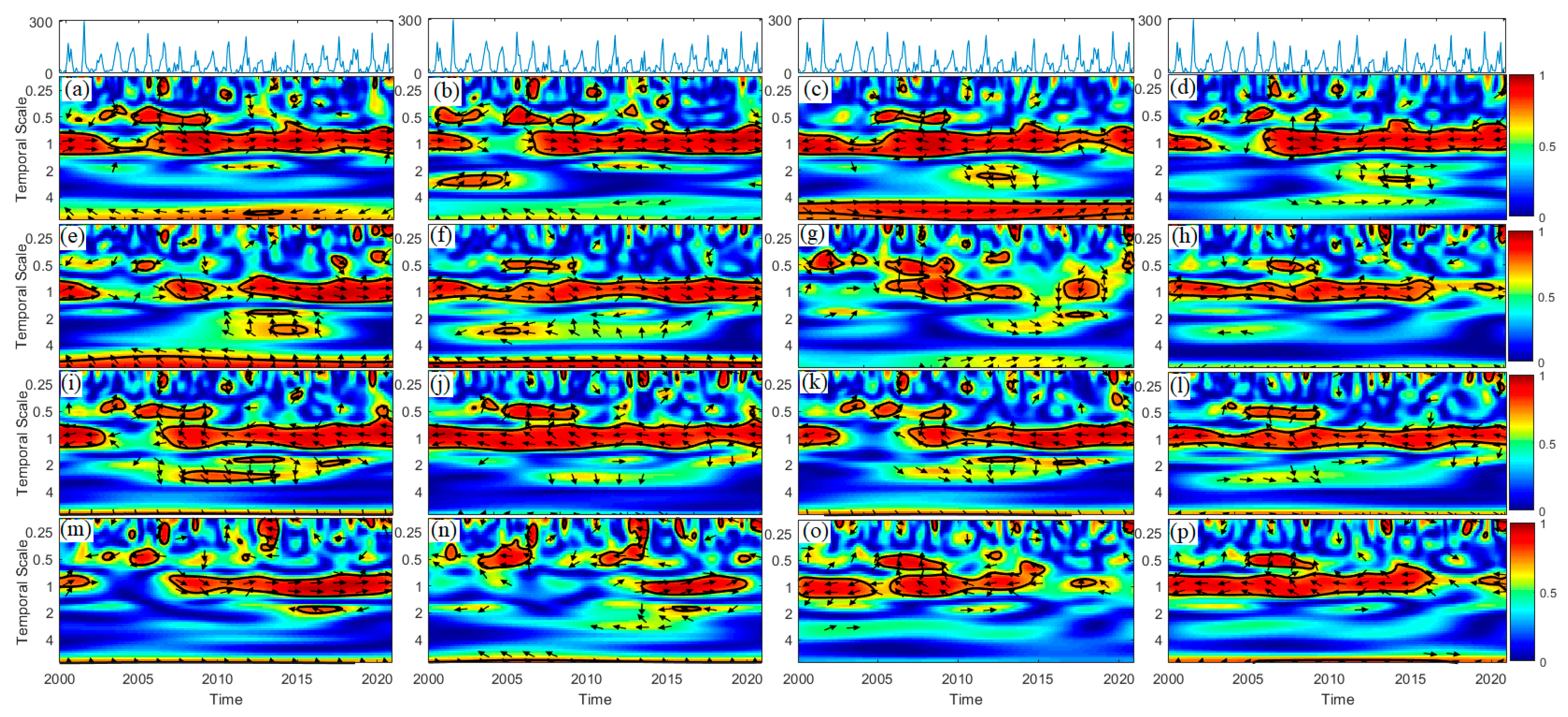
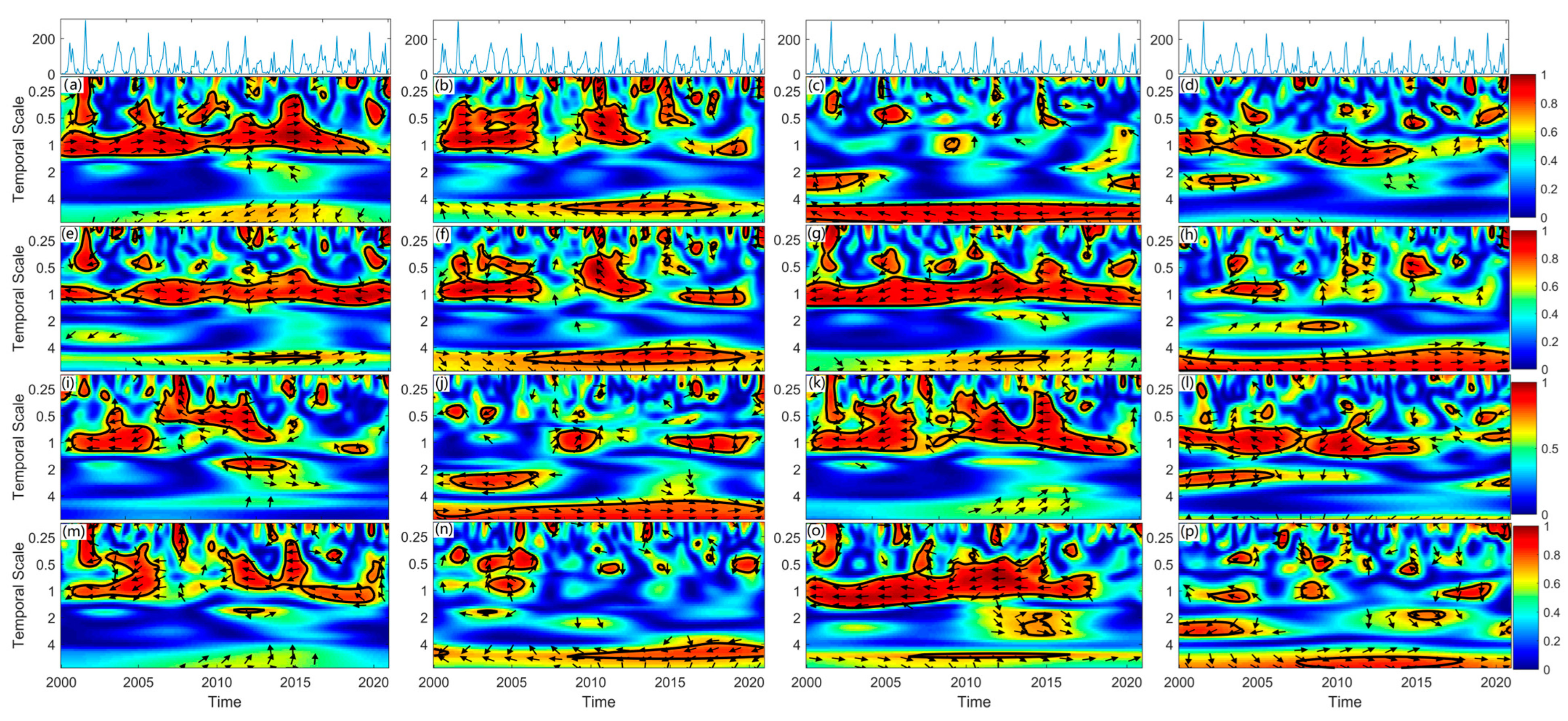
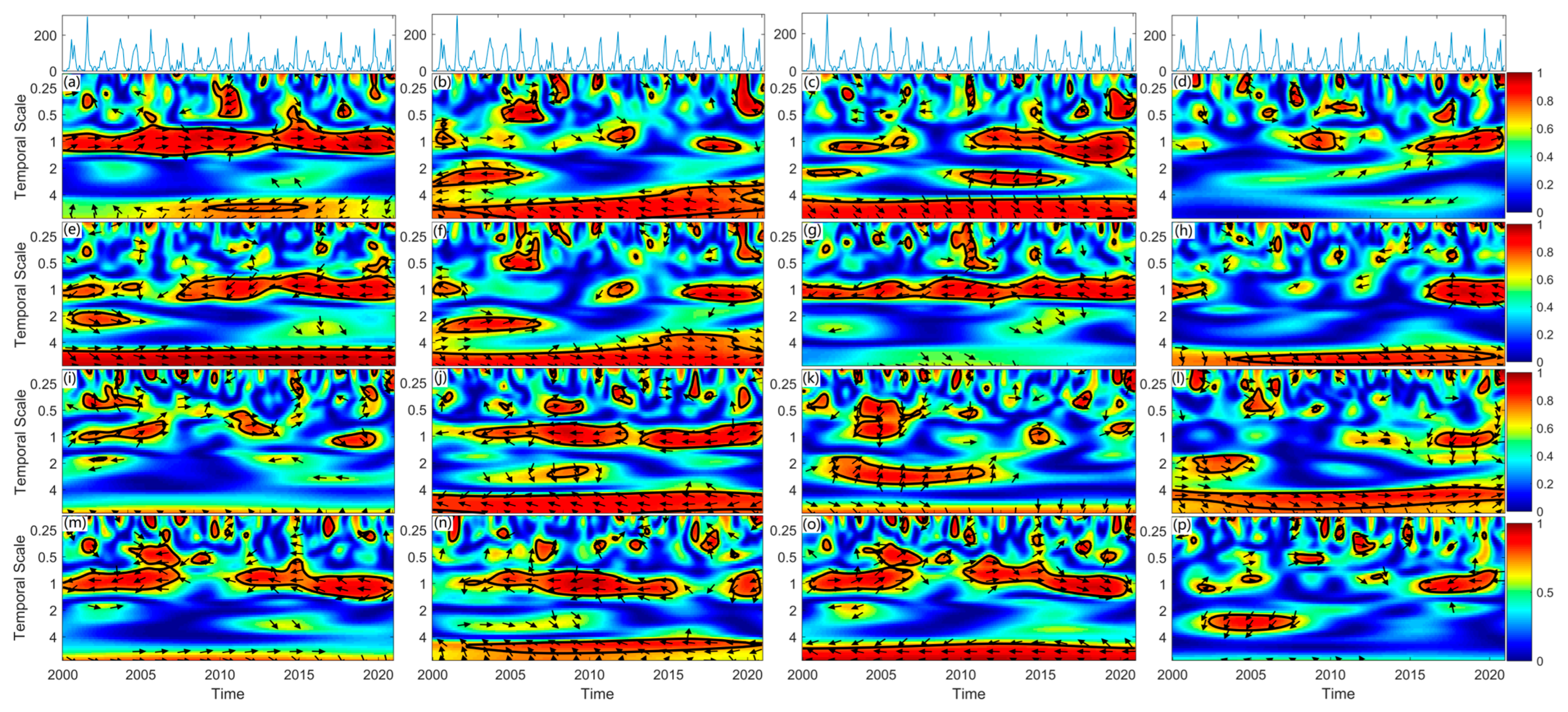
2.4. Data Analysis
3. Results
3.1. SWC and Environmental Factors in Coal and Non-Coal Mining Areas
3.2. Relationships Between SWC and Environmental Factors in Coal and Non-Coal Mining Areas
3.3. Differences Between Coal and Non-Coal Mining Areas
4. Discussion
4.1. SWC and Environmental Factors
4.2. Relationships Between SWC and Environmental Factors
4.3. Differences Between Coal and Non-Coal Mining Areas
5. Conclusions
Author Contributions
Funding
Institutional Review Board Statement
Informed Consent Statement
Data Availability Statement
Conflicts of Interest
References
- Zhu, H.; Meason, D.F.; Salekin, S.; Hu, W.; Lad, P.; Jing, Y.; Xue, J. Time stability of soil volumetric water content and its optimal sampling design in contrasting forest catchments. J. Hydrol. 2024, 636, 131344. [Google Scholar] [CrossRef]
- Kang, S.; Hao, X.; Du, T.; Tong, L.; Su, X.; Lu, H.; Li, X.; Huo, Z.; Li, S.; Ding, R. Improving agricultural water productivity to ensure food security in China under changing environment: From research to practice. Agric. Water Manag. 2017, 179, 5–17. [Google Scholar] [CrossRef]
- Lal, R.; Bouma, J.; Brevik, E.; Dawson, L.; Field, D.J.; Glaser, B.; Hatano, R.; Hartemink, A.E.; Kosaki, T.; Lascelles, B. Soils and sustainable development goals of the United Nations: An International Union of Soil Sciences perspective. Geoderma Reg. 2021, 25, e00398. [Google Scholar] [CrossRef]
- Rouhani, A.; Gusiatin, M.Z.; Hejcman, M. An overview of the impacts of coal mining and processing on soil: Assessment, monitoring, and challenges in the Czech Republic. Environ. Geochem. Health 2023, 45, 7459–7490. [Google Scholar] [CrossRef] [PubMed]
- Zhang, Z.; Wang, J.; Li, B. Determining the influence factors of soil organic carbon stock in opencast coal-mine dumps based on complex network theory. CATENA 2019, 173, 433–444. [Google Scholar] [CrossRef]
- Qiu, D.; Xu, R.; Gao, P.; Mu, X. Effect of vegetation restoration type and topography on soil water storage and infiltration capacity in the Loess Plateau, China. CATENA 2024, 241, 108079. [Google Scholar] [CrossRef]
- Lei, C.; Wagner, P.D.; Fohrer, N. Effects of land cover, topography, and soil on stream water quality at multiple spatial and seasonal scales in a German lowland catchment. Ecol. Indic. 2021, 120, 106940. [Google Scholar] [CrossRef]
- Srivastava, A.; Saco, P.M.; Rodriguez, J.F.; Kumari, N.; Chun, K.P.; Yetemen, O. The role of landscape morphology on soil moisture variability in semi-arid ecosystems. Hydrol. Process. 2021, 35, e13990. [Google Scholar] [CrossRef]
- Seneviratne, S.I.; Corti, T.; Davin, E.L.; Hirschi, M.; Jaeger, E.B.; Lehner, I.; Orlowsky, B.; Teuling, A.J. Investigating soil moisture–climate interactions in a changing climate: A review. Earth Sci. Rev. 2010, 99, 125–161. [Google Scholar] [CrossRef]
- Yinglan, A.; Wang, G.; Sun, W.; Xue, B.; Kiem, A. Stratification response of soil water content during rainfall events under different rainfall patterns. Hydrol. Process. 2018, 32, 3128–3139. [Google Scholar] [CrossRef]
- Rajkai, K.; Tóth, B.; Barna, G.; Hernádi, H.; Kocsis, M.; Makó, A. Particle-size and organic matter effects on structure and water retention of soils. Biologia 2015, 70, 1456–1461. [Google Scholar] [CrossRef]
- Feng, X.; Li, J.; Cheng, W.; Fu, B.; Wang, Y.; Lü, Y.; Shao, M.a. Evaluation of AMSR-E retrieval by detecting soil moisture decrease following massive dryland re-vegetation in the Loess Plateau, China. Remote Sens. Environ. 2017, 196, 253–264. [Google Scholar] [CrossRef]
- Feng, Y.; Wang, J.; Bai, Z.; Reading, L. Effects of surface coal mining and land reclamation on soil properties: A review. Earth Sci. Rev. 2019, 191, 12–25. [Google Scholar] [CrossRef]
- Acín-Carrera, M.; José Marques, M.; Carral, P.; Álvarez, A.M.; López, C.; Martín-López, B.; González, J.A. Impacts of land-use intensity on soil organic carbon content, soil structure and water-holding capacity. Soil Use Manag. 2013, 29, 547–556. [Google Scholar] [CrossRef]
- Rabot, E.; Wiesmeier, M.; Schlüter, S.; Vogel, H.J. Soil structure as an indicator of soil functions: A review. Geoderma 2018, 314, 122–137. [Google Scholar] [CrossRef]
- García-Palacios, P.; Maestre, F.T.; Bardgett, R.D.; de Kroon, H. Plant responses to soil heterogeneity and global environmental change. J. Ecol. 2012, 100, 1303–1314. [Google Scholar] [CrossRef]
- Hutchings, M.J.; John, E.A.; Wijesinghe, D.K. Toward understanding the consequences of soil heterogeneity for plant populations and communities. Ecology 2003, 84, 2322–2334. [Google Scholar] [CrossRef]
- Clément, F.; Ruiz, J.; Rodríguez, M.A.; Blais, D.; Campeau, S. Landscape diversity and forest edge density regulate stream water quality in agricultural catchments. Ecol. Indic. 2017, 72, 627–639. [Google Scholar] [CrossRef]
- Khan, S.A.; Mulvaney, R.L.; Ellsworth, T.R. The potassium paradox: Implications for soil fertility, crop production and human health. Renew. Agric. Food Syst. 2014, 29, 3–27. [Google Scholar] [CrossRef]
- Das, I.; Pradhan, M. Potassium-Solubilizing Microorganisms and Their Role in Enhancing Soil Fertility and Health. In Potassium Solubilizing Microorganisms for Sustainable Agriculture; Meena, V.S., Maurya, B.R., Verma, J.P., Meena, R.S., Eds.; Springer: New Delhi, India, 2016; pp. 281–291. [Google Scholar]
- Tang, F.; Ma, T.; Tang, J.; Yang, Q.; Xue, J.; Zhu, C.; Wang, C. Space-time dynamics and potential drivers of soil moisture and soil nutrients variation in a coal mining area of semi-arid, China. Ecol. Indic. 2023, 157, 111242. [Google Scholar] [CrossRef]
- de Queiroz, M.G.; da Silva, T.G.F.; Zolnier, S.; Jardim, A.M.d.R.F.; de Souza, C.A.A.; Araújo Júnior, G.d.N.; de Morais, J.E.F.; de Souza, L.S.B. Spatial and temporal dynamics of soil moisture for surfaces with a change in land use in the semi-arid region of Brazil. CATENA 2020, 188, 104457. [Google Scholar] [CrossRef]
- Sadeghi, S.H.R.; Khazayi, M.; Mirnia, S.K. Effect of soil surface disturbance on overland flow, sediment yield, and nutrient loss in a hyrcanian deciduous forest stand in Iran. CATENA 2022, 218, 106546. [Google Scholar] [CrossRef]
- Wang, Z.; Lechner, A.M.; Yang, Y.; Baumgartl, T.; Wu, J. Mapping the cumulative impacts of long-term mining disturbance and progressive rehabilitation on ecosystem services. Sci. Total Environ. 2020, 717, 137214. [Google Scholar] [CrossRef]
- Zhang, K.; Chen, M.; Feng, S.; Chen, X.; Yan, Z. Effects of coal mining disturbance on spatial and temporal distribution of soil water content in Northwest China-based on 3D EBK model. Hydrol. Process. 2024, 38, e15277. [Google Scholar] [CrossRef]
- Zhang, Y.; Yang, J.-y.; Wu, H.-l.; Shi, C.-q.; Zhang, C.-l.; Li, D.-x.; Feng, M.-m. Dynamic changes in soil and vegetation during varying ecological-recovery conditions of abandoned mines in Beijing. Ecol. Eng. 2014, 73, 676–683. [Google Scholar] [CrossRef]
- Zhu, H.F.; Nan, F.; Xu, Z.J.; Jing, Y.D.; Duan, Y.H.; Bi, R.T. Multi-scale spatial relationships between soil organic matter and influencing factors in basins of the Chinese Loess Plateau. Acta Ecol. Sin. 2017, 37, 8348–8360. [Google Scholar] [CrossRef]
- Pratiwi; Narendra, B.H.; Siregar, C.A.; Turjaman, M.; Hidayat, A.; Rachmat, H.H.; Mulyanto, B.; Suwardi; Iskandar; Maharani, R.; et al. Managing and Reforesting Degraded Post-Mining Landscape in Indonesia: A Review. Land 2021, 10, 658. [Google Scholar] [CrossRef]
- Liu, X.; Wu, J.Q.; Conrad, P.W.; Dun, S.; Todd, C.S.; McNearny, R.L.; Elliot, W.; Rhee, H.; Clark, P. Impact of surface coal mining on soil hydraulic properties. Trans. Soc. Min. Metall. Explor. 2016, 338, 381–392. [Google Scholar]
- Rashmi, I.; Kala, S.; Sharma, G.K.; Kumar, A.; Ali, S.; Kumar, K.; Kumawat, A.; Meena, G.L.; Meena, H.; Pal, R. Impact of Post-mining Restoration Techniques on Soil Health. In Ecological Impacts of Stone Mining: Assessment and Restoration of Soil, Water, Air and Flora; Springer: Singapore, 2024; pp. 267–284. [Google Scholar]


| Areas | Spatial Variables | Temporal Variables | 10 cm | 30 cm | 50 cm |
|---|---|---|---|---|---|
| Coal mining area | Mean | Mean | 25.21 | 22.78 | 22.69 |
| SDt | 3.50 | 3.06 | 3.18 | ||
| CVt | 13.89 | 13.43 | 14.01 | ||
| SDs | Mean | 5.72 | 9.25 | 9.45 | |
| SDt | 2.73 | 6.45 | 8.37 | ||
| CVt | 47.82 | 69.76 | 88.58 | ||
| CVs | Mean | 23.31 | 39.88 | 41.19 | |
| SDt | 11.71 | 26.29 | 32.45 | ||
| CVt | 50.23 | 65.92 | 78.79 | ||
| Non-coal mining area | Mean | Mean | 25.09 | 22.96 | 22.60 |
| SDt | 3.47 | 3.39 | 2.97 | ||
| CVt | 13.82 | 14.75 | 13.16 | ||
| SDs | Meant | 4.32 | 7.86 | 8.30 | |
| SDt | 2.60 | 6.53 | 7.31 | ||
| CVt | 60.13 | 83.07 | 88.03 | ||
| CVs | Mean | 17.51 | 33.90 | 35.98 | |
| SDt | 10.62 | 26.87 | 27.92 | ||
| CVt | 60.64 | 79.27 | 77.60 |
| Areas | Environmental Factors | Min. | Mean | Max. | SD | CV | p | |
|---|---|---|---|---|---|---|---|---|
| Coal mining area | Topographic indicators | Altitude (m) | 730.00 | 849.02 | 1035.00 | 68.98 | 8.13 | 0.43 |
| Aspect (-) | −1.00 | −0.11 | 1.00 | 0.70 | −614.21 | 0.14 | ||
| Slope (°) | 0.00 | 0.17 | 0.45 | 0.12 | 71.78 | 0.73 | ||
| TWI (-) | 3.97 | 7.68 | 20.83 | 4.05 | 52.70 | 0.45 | ||
| CGI (-) | −29.11 | −1.03 | 13.74 | 8.38 | −810.66 | 0.21 | ||
| GCVR (-) | −0.04 | 0.00 | 0.04 | 0.01 | 4671.26 | 0.66 | ||
| VAD (-) | 5.62 | 63.19 | 121.62 | 31.12 | 49.25 | 0.41 | ||
| Soil physical indicators | Sand (-) | 0.09 | 0.23 | 0.64 | 0.09 | 40.43 | 0.03 * | |
| Silt (-) | 0.22 | 0.48 | 0.66 | 0.10 | 21.55 | 0.17 | ||
| Clay (-) | 0.14 | 0.29 | 0.48 | 0.08 | 27.02 | 0.69 | ||
| SBD (g/cm3) | 1.03 | 1.24 | 1.53 | 0.11 | 8.82 | 0.05 * | ||
| SP (%) | 42.08 | 53.38 | 60.98 | 4.11 | 7.70 | 0.05 * | ||
| Soil chemical indicators | pH (-) | 6.49 | 8.02 | 8.45 | 0.30 | 3.73 | 0.20 | |
| SOM (g/kg) | 1.10 | 17.82 | 36.42 | 7.95 | 44.64 | 0.42 | ||
| SAN (mg/kg) | 7.42 | 32.21 | 57.48 | 12.01 | 37.29 | 0.03 * | ||
| SAP (mg/kg) | 0.95 | 8.15 | 23.18 | 4.29 | 52.61 | 0.16 | ||
| SAK (mg/kg) | 60.30 | 151.94 | 311.55 | 40.87 | 26.90 | 0.06 | ||
| Non-coal mining area | Topographic indicators | Altitude (m) | 743.00 | 858.64 | 977.00 | 53.21 | 6.20 | — |
| Aspect (-) | −1.00 | 0.09 | 1.00 | 0.72 | 800.65 | — | ||
| Slope (°) | 0.00 | 0.16 | 0.53 | 0.12 | 77.65 | — | ||
| TWI (-) | 4.73 | 7.15 | 15.10 | 2.77 | 38.79 | — | ||
| CGI (-) | −22.91 | 1.03 | 28.23 | 8.40 | 816.98 | — | ||
| GCVR (-) | −0.02 | 0.00 | 0.02 | 0.01 | −1202.27 | — | ||
| VAD (-) | 0.00 | 44.20 | 98.16 | 25.35 | 57.35 | — | ||
| Soil physical indicators | Sand (-) | 0.09 | 0.19 | 0.67 | 0.10 | 52.84 | — | |
| Silt (-) | 0.18 | 0.53 | 0.70 | 0.11 | 20.02 | — | ||
| Clay (-) | 0.13 | 0.28 | 0.56 | 0.08 | 29.57 | — | ||
| SBD (g/cm3) | 0.99 | 1.18 | 1.36 | 0.09 | 7.30 | — | ||
| SP (%) | 48.56 | 55.46 | 62.62 | 3.25 | 5.86 | — | ||
| Soil chemical indicators | pH (-) | 7.03 | 7.94 | 8.51 | 0.27 | 3.43 | — | |
| SOM (g/kg) | 4.72 | 18.99 | 40.17 | 6.38 | 33.62 | — | ||
| SAN (mg/kg) | 5.56 | 39.05 | 66.75 | 12.30 | 31.51 | — | ||
| SAP (mg/kg) | 1.52 | 9.71 | 32.30 | 7.05 | 72.62 | — | ||
| SAK (mg/kg) | 70.35 | 166.86 | 244.55 | 36.85 | 22.08 | — | ||
| Areas | Environmental Factors | Min. | Mean | Max. | SD | Mean (-) | Mean (+) | |
|---|---|---|---|---|---|---|---|---|
| Coal mining area (n = 59) | Topographic indicators | Altitude | −0.60 ** | 0.30 * | 0.82 ** | 0.33 | −0.20 | 0.45 ** |
| Aspect | −0.20 | 0.04 | 0.23 | 0.08 | −0.06 | 0.08 | ||
| Slope | −0.33 ** | 0.16 | 0.50 ** | 0.19 | −0.11 | 0.25 * | ||
| TWI | −0.29 | −0.05 | 0.22 | 0.11 | −0.11 | 0.08 | ||
| CGI | −0.32 * | −0.03 | 0.30 * | 0.10 | −0.08 | 0.09 | ||
| GCVR | −0.33 * | −0.03 | 0.33 * | 0.12 | −0.10 | 0.12 | ||
| VAD | −0.56 ** | −0.12 | 0.28 * | 0.15 | −0.18 | 0.08 | ||
| Soil physical indicators | Sand | −0.22 | 0.04 | 0.32 * | 0.10 | −0.06 | 0.10 | |
| Silt | −0.32 * | −0.02 | 0.41 ** | 0.15 | −0.13 | 0.12 | ||
| Clay | −0.44 ** | −0.02 | 0.28 * | 0.15 | −0.14 | 0.12 | ||
| SBD | −0.16 | 0.11 | 0.37 ** | 0.11 | −0.06 | 0.15 | ||
| SP | −0.37 ** | −0.11 | 0.16 | 0.11 | −0.15 | 0.06 | ||
| Soil chemical indicators | pH | −0.30 * | 0.00 | 0.40 ** | 0.16 | −0.13 | 0.13 | |
| SOM | −0.53 ** | 0.04 | 0.60 ** | 0.29 | −0.24 | 0.27 * | ||
| SAN | −0.52 ** | 0.01 | 0.54 ** | 0.24 | −0.20 | 0.20 | ||
| SAP | −0.42 ** | −0.05 | 0.43 ** | 0.22 | −0.20 | 0.20 | ||
| SAK | −0.37 ** | −0.14 | 0.38 ** | 0.13 | −0.18 | 0.13 | ||
| Non-coal mining area (n = 47) | Topographic indicators | Altitude | −0.52 ** | 0.19 | 0.77 ** | 0.26 | −0.16 | 0.30 * |
| Aspect | −0.19 | −0.01 | 0.20 | 0.08 | −0.07 | 0.07 | ||
| Slope | −0.28 * | 0.12 | 0.35 ** | 0.13 | −0.08 | 0.17 | ||
| TWI | −0.25 | −0.05 | 0.28 * | 0.09 | −0.09 | 0.06 | ||
| CGI | −0.23 | −0.01 | 0.24 | 0.10 | −0.08 | 0.08 | ||
| GCVR | −0.24 | 0.02 | 0.29 * | 0.09 | −0.05 | 0.08 | ||
| VAD | −0.54 ** | −0.08 | 0.30 * | 0.17 | −0.17 | 0.10 | ||
| Soil physical indicators | Sand | −0.27 | 0.03 | 0.25 | 0.12 | −0.09 | 0.11 | |
| Silt | −0.29 * | 0.02 | 0.40 * | 0.15 | −0.11 | 0.14 | ||
| Clay | −0.28 * | −0.06 | 0.21 | 0.10 | −0.11 | 0.07 | ||
| SBD | −0.32 * | 0.09 | 0.36 * | 0.15 | −0.11 | 0.16 | ||
| SP | −0.36 * | −0.09 | 0.32 * | 0.15 | −0.16 | 0.11 | ||
| Soil chemical indicators | pH | −0.27 | −0.06 | 0.25 | 0.12 | −0.13 | 0.09 | |
| SOM | −0.45 ** | −0.03 | 0.45 ** | 0.22 | −0.19 | 0.20 | ||
| SAN | −0.42 ** | −0.02 | 0.43 ** | 0.19 | −0.18 | 0.14 | ||
| SAP | −0.30 * | −0.09 | 0.22 | 0.12 | −0.15 | 0.08 | ||
| SAK | −0.33 * | −0.14 | 0.34 * | 0.14 | −0.19 | 0.10 | ||
| Depths | Areas | Factors | Scales | Type of Correlation | |||
|---|---|---|---|---|---|---|---|
| <1 Year | 1–4 Year | >4 Year | All | ||||
| 10 cm | Coal mining area | Altitude | 20.52 | 14.84 | 0.69 | 16.39 | Positive |
| GCVR | 17.17 | 16.95 | 55.74 | 25.45 | 1 year negative and >4 year positive | ||
| VAD | 13.93 | 12.67 | 38.75 | 19.05 | 1 year positive and >4 year negative | ||
| Sand | 15.47 | 4.10 | 0.00 | 9.48 | Positive | ||
| SOM | 19.59 | 15.36 | 9.09 | 17.63 | Around 1 year negative | ||
| SAN | 16.64 | 12.18 | 7.57 | 14.62 | Negative | ||
| SAP | 15.41 | 10.69 | 9.09 | 13.68 | Positive | ||
| SAK | 15.00 | 8.02 | 0.00 | 10.78 | Negative | ||
| Non-coal mining area | Altitude | 20.85 | 15.31 | 0.00 | 16.62 | Positive | |
| GCVR | 16.95 | 12.80 | 0.00 | 13.65 | Negative | ||
| VAD | 14.29 | 14.79 | 30.24 | 18.54 | 1 year positive and >4 year negative | ||
| Sand | 13.40 | 8.80 | 0.00 | 10.27 | Positive | ||
| SOM | 23.20 | 16.32 | 0.00 | 18.21 | Negative | ||
| SAN | 17.71 | 12.18 | 6.59 | 14.98 | Negative | ||
| SAP | 14.18 | 4.61 | 10.47 | 10.91 | Unstable | ||
| SAK | 18.21 | 11.04 | 12.64 | 15.88 | Negative | ||
| 30 cm | Coal mining area | Altitude | 30.02 | 11.64 | 0.00 | 19.84 | Positive |
| Aspect | 4.54 | 5.30 | 62.80 | 15.71 | Negative | ||
| CGI | 21.78 | 11.89 | 4.67 | 16.59 | Negative | ||
| GCVR | 26.19 | 18.04 | 2.03 | 20.78 | Negative at around 1 year | ||
| Silt | 21.78 | 7.79 | 0.00 | 14.13 | Mainly negative | ||
| SOM | 30.33 | 8.28 | 0.00 | 18.67 | Mainly negative | ||
| SAN | 22.55 | 6.56 | 0.00 | 14.04 | Mainly negative | ||
| SAK | 27.61 | 16.20 | 7.71 | 21.79 | Mainly negative | ||
| Non-coal mining area | Altitude | 28.78 | 3.15 | 18.44 | 19.19 | Positive | |
| Aspect | 11.03 | 15.55 | 0.00 | 11.72 | Positive | ||
| CGI | 21.91 | 5.11 | 26.84 | 17.99 | <1 year negative and >4 year positive | ||
| GCVR | 8.85 | 1.54 | 55.31 | 15.08 | Positive | ||
| Silt | 6.72 | 10.09 | 59.36 | 18.09 | Positive | ||
| SOM | 13.17 | 15.97 | 0.00 | 12.98 | Negative | ||
| SAN | 9.95 | 0.61 | 27.16 | 10.20 | Negative | ||
| SAK | 6.08 | 10.13 | 22.46 | 11.12 | Mainly positive | ||
| 50 cm | Coal mining area | Altitude | 20.54 | 18.33 | 9.05 | 19.28 | 1 year positive and >4 year negative |
| Slope | 10.56 | 20.37 | 76.60 | 27.20 | Negative | ||
| CGI | 12.84 | 13.50 | 69.29 | 24.33 | 1 year negative and >4 year positive | ||
| GCVR | 13.94 | 16.60 | 0.00 | 13.62 | Negative | ||
| Clay | 10.76 | 3.09 | 0.00 | 6.68 | Mainly positive | ||
| SBD | 12.49 | 12.83 | 5.76 | 12.44 | Mainly positive | ||
| SOM | 18.92 | 10.19 | 1.99 | 13.98 | Negative | ||
| pH | 20.99 | 7.15 | 64.18 | 25.05 | 1 year positive and >4 year negative | ||
| Non-coal mining area | Altitude | 10.90 | 13.16 | 73.45 | 23.96 | Negative | |
| Slope | 8.43 | 5.58 | 0.00 | 6.48 | Mainly positive | ||
| CGI | 9.14 | 14.76 | 71.13 | 23.28 | Mainly positive | ||
| GCVR | 5.80 | 6.51 | 29.77 | 10.87 | Mainly positive | ||
| Clay | 15.54 | 12.22 | 75.26 | 26.28 | Negative | ||
| SBD | 6.00 | 9.15 | 52.92 | 16.19 | Positive | ||
| SOM | 13.38 | 11.49 | 37.52 | 18.09 | Mainly negative | ||
| pH | 7.08 | 9.83 | 0.00 | 7.47 | Negative | ||
Disclaimer/Publisher’s Note: The statements, opinions and data contained in all publications are solely those of the individual author(s) and contributor(s) and not of MDPI and/or the editor(s). MDPI and/or the editor(s) disclaim responsibility for any injury to people or property resulting from any ideas, methods, instructions or products referred to in the content. |
© 2025 by the authors. Licensee MDPI, Basel, Switzerland. This article is an open access article distributed under the terms and conditions of the Creative Commons Attribution (CC BY) license (https://creativecommons.org/licenses/by/4.0/).
Share and Cite
Jing, Y.; Chen, Y.; Yang, J.; Ding, H.; Zhu, H. Topographic and Edaphic Influences on the Spatiotemporal Soil Water Content Patterns in Underground Mining Regions. Appl. Sci. 2025, 15, 984. https://doi.org/10.3390/app15020984
Jing Y, Chen Y, Yang J, Ding H, Zhu H. Topographic and Edaphic Influences on the Spatiotemporal Soil Water Content Patterns in Underground Mining Regions. Applied Sciences. 2025; 15(2):984. https://doi.org/10.3390/app15020984
Chicago/Turabian StyleJing, Yaodong, Yu Chen, Jason Yang, Haoxi Ding, and Hongfen Zhu. 2025. "Topographic and Edaphic Influences on the Spatiotemporal Soil Water Content Patterns in Underground Mining Regions" Applied Sciences 15, no. 2: 984. https://doi.org/10.3390/app15020984
APA StyleJing, Y., Chen, Y., Yang, J., Ding, H., & Zhu, H. (2025). Topographic and Edaphic Influences on the Spatiotemporal Soil Water Content Patterns in Underground Mining Regions. Applied Sciences, 15(2), 984. https://doi.org/10.3390/app15020984