Article

Paleo-Asian Ocean Ridge Subduction: Evidence from Volcanic Rocks in the Fuyun–Qinghe Area, Southern Margin of the Chinese Altay

1
School of Earth Sciences and Resources, China University of Geosciences, Beijing 100083, China
2
Institute of Geology, Chinese Academy of Geological Sciences, Beijing 100037, China
3
Geologic Party No. 216, China National Nuclear Corporation, Urumqi 830011, China
4
217 Geological Team of Shanxi Provincial Geological Prospecting Bureau, Datong 037008, China
*
Author to whom correspondence should be addressed.
Appl. Sci. 2025, 15(7), 3736; https://doi.org/10.3390/app15073736
Submission received: 11 February 2025 / Revised: 17 March 2025 / Accepted: 26 March 2025 / Published: 28 March 2025
(This article belongs to the Special Issue Recent Advances in Geochemistry)

Abstract

:
The Chinese Altay is located in the western segment of the Central Asian Orogenic Belt (CAOB) and preserves critical records of the Paleo-Asian Ocean (PAO) Plate evolution during the Paleozoic era. This region also hosts significant mineral deposits, making it a focal point for geological research. In this paper, field investigation, petrology, mineralogy, and petrography studies were conducted on volcanic rocks in the Fuyun–Qinghe area, southern margin of the Chinese Altay, and the paper provided new zircon LA-ICP-MS dating data, Lu-Hf isotope data, and whole-rock geochemical data of the basaltic to andesitic volcanic rocks. Thus, the formation age, petrogenesis, and tectonic setting of these rocks were discussed, which was of great significance to reveal the nature of the PAO Plate. The findings showed that the basaltic andesitic volcanic breccia was formed at 382.9 ± 3.4 Ma, the basalt was 401.7 ± 4.7 Ma, and the andesites were 405.1 ± 5.6 Ma and 404.8 ± 6.7 Ma, which indicated that the above rocks were formed in the Early–Middle Devonian. The volcanic rock assemblages were hawaiite, mugearite, potassic trachybasalt, basaltic andesite, andesite, benmoreite, etc., which contained labeled magmatic rocks such as adakite, sub-boninite, niobium-enriched arc basalt (NEAB), picrite, high-magnesium andesite (HMA), and magnesium andesite (MA). Comprehensive analysis indicated that magma probably mainly originated from three sources: (1) partial melting of the PAO slab, (2) partial melting of the overlying garnet–spinel lherzolite mantle peridotite metasomatized by subducting-related fluids (melts), and (3) a possible input of the asthenosphere. Comparative analysis with modern analogs (e.g., Chile Triple Junction) indicates that ridge subduction of the PAO had existed in the Fuyun–Qinghe area during the Early–Middle Devonian. Based on available evidence, we tentatively named the oceanic plates in this region the central Fuyun–Qinghe Ridge and the Junggar Ocean Plates, separated by the ridge on both sides. Although the ocean had a certain scale, it had entered the climax period of transition from ocean to continent.

1. Introduction

The CAOB is the largest Phanerozoic accretionary orogenic belt in the world, documenting the subduction and extinction history of the PAO Plate [1,2,3]. Over its extensive geological history, the expansion, subduction, closure, and extinction of the PAO have profoundly influenced the CAOB. The Chinese Altay, located in northern Xinjiang Province, is a crucial component of the western section of the CAOB. Its complex multi-stage tectonic evolution and extensive magmatism–tectonism–mineralization have been a hot topic for global researchers. It is generally accepted that the PAO began subducting during the Neoproterozoic to Early Paleozoic [4,5,6,7], with the most intense subduction occurring in the early Late Paleozoic. The closure time of the western segment of the PAO remains contentious, with proposed dates ranging from the Late Devonian [8], Early Carboniferous [9], Late Carboniferous or Permian [10,11,12,13], Late Permian to Triassic [14], to the Middle to Late Triassic [15,16]. Thus, at the latest, the western part of the ocean closed during the Middle to Late Triassic.
The Chinese Altay was undoubtedly influenced by the evolution of the PAO during the Late Paleozoic. Most scholars agree that the PAO was in a subduction stage during this period [17,18,19]. However, debates persist regarding the specific subduction setting and the nature of the PAO slab. For instance, Zhang et al. [20] proposed that the Devonian volcanic rocks formed in an island arc setting with varying degrees of maturity, transitioning to an intraplate setting in the Permian. Liang et al. [21] suggested that the eastern Junggar and southern margin of the Chinese Altay were in an island arc setting during the Early and Middle Devonian, followed by a collision setting in the Late Devonian, post-collision in the Early Carboniferous, and intraplate extension from the late Early Carboniferous to the Late Carboniferous. Xu et al. [22] studied the ophiolites in the Kurt area and concluded that they were the products of a Late Paleozoic back-arc basin system. Zheng et al. [19] proposed that the Early Devonian Xiaodonggou granites in the Kelan basin formed in an active continental margin arc setting. Niu et al. [17] found volcanic rocks with diverse source characteristics in the limited Devonian strata on the southern margin of the Chinese Altay, attributed to the complex accretion and tectonic processes during the Devonian to Carboniferous. Recently, scholars have proposed that ridge subduction could be a new model to explain the Late Paleozoic subduction processes in the Chinese Altay, based on studies of mafic complexes and veins [2,23], basalts and dacites [24], gabbros [3], and granites [25]. They posited that ridge subduction played a significant tectonic role in the evolution of the Altay Orogenic Belt.
The ridge subduction model has gained attention in recent years, exemplified by the Chile Trench (the Nazca–Atlantic–South American ridge–trench–trench triple junction [26,27]), southern Alaska, western California [28] and so on (Figure 1). Mantle convection causes upwelling at the ridge axis, driving mid-ocean ridge expansion and crust formation. The basaltic oceanic crust formed at the ridge cools and subducts, with magma from the ridge intruding near the trench, marking the onset of ridge subduction [29]. In these regions, ridge subduction generates new magmatic arcs and distinctive rock assemblages with unique geochemical characteristics [26,27]. Shen et al. [30] proposed ridge subduction in the Chinese Altay and summarized the petrological evidence, though they did not address the spatial distribution of plates, the migration of triple junctions, or the pattern of ridge subduction.
The ridge subduction model challenges traditional views on magmatic arcs. Despite its significance, it remains understudied, particularly regarding ancient mid-ocean ridge subduction. Nonetheless, it offers a crucial avenue for exploring extinct ancient oceanic slabs.
This study, based on the concept of ridge subduction and magmatic arc examples, focuses on volcanic rocks in the Fuyun–Qinghe region, located at the junction of the southern margin of the Altay Orogenic Belt and northeast Junggar in China. The research aims to reveal the formation age, rock assemblages, and characteristics of these rocks, discuss their petrogenesis, and compare them with magmatic arcs formed by mid-ocean ridge subduction in Chile. This study seeks to infer the types of Fuyun–Qinghe magmatic arcs and the properties of the subducting oceanic slabs related to the PAO subduction. This research holds significant theoretical and practical importance for understanding the evolution of the PAO and regional magmatism and mineralization.

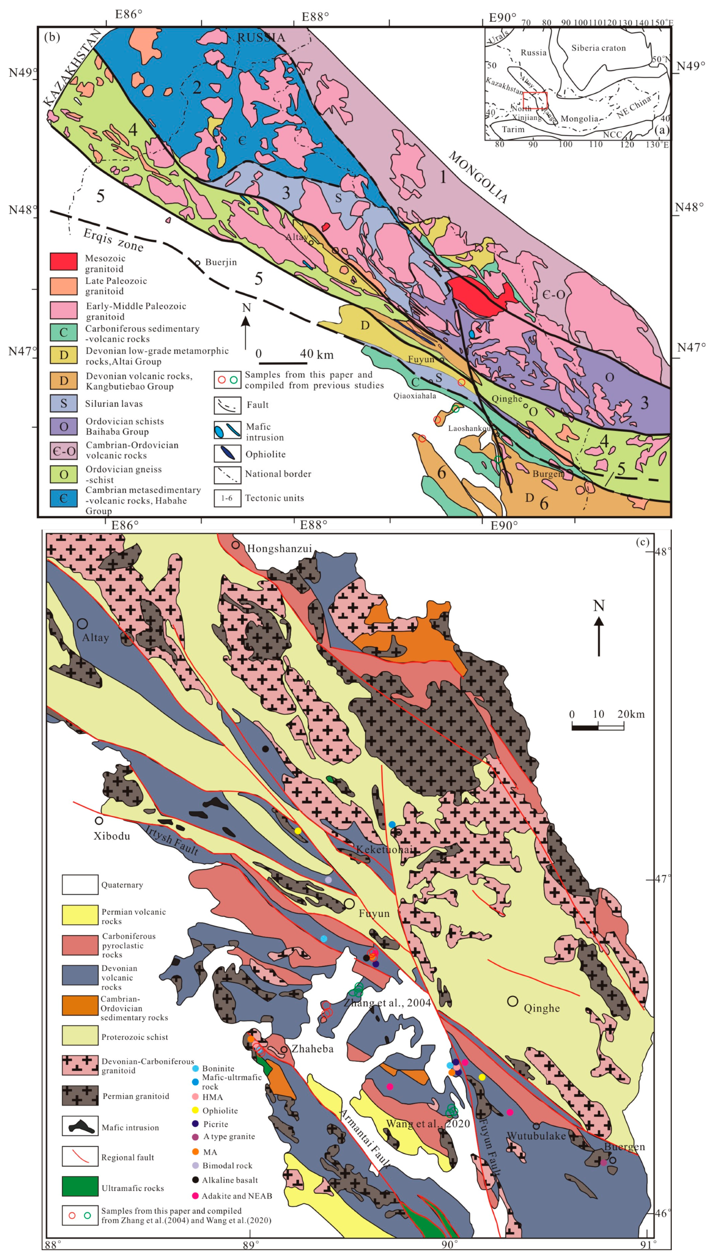
2. Geological Background

The Chinese Altay is located in the northern part of the Xinjiang Uygur Autonomous Region, between the Sayan Block to the north and the Junggar Block to the south (Figure 2a). According to Windley et al. [32] and Wang et al. [33], the Altay orogenic belt comprises six blocks (or units) (Figure 2b): the Northeast Altay Block, Northwest Altay Block, Central Altay Block, Qiongkuer–Abagong Block, Irtysh Block, and Buerjin–Ertai Block. The study area is situated in the Buerjin–Ertai Block.
Strata in this area were relatively fully exposed, primarily consisting of Proterozoic and Paleozoic strata. The oldest stratum was Paleoproterozoic Kumuqi Group, while the youngest was Quaternary stratum, Cretaceous strata were generally absent. In the Fuyun-Qinghe area, the major exposed Paleozoic strata included Late Ordovician Baihaba Formation, late Devonian Kangbutiebao Formation, Tuoranggekuduke Formation, Middle Devonian Altay Formation, Beitashan Formation, Ashele Formation, Yundukala Formation, and so on [34]. The Tuoranggekuduke Formation was a series of marine clastic rocks and volcanic sedimentary clastic rocks with lavas, containing brachiopods, corals, trilobites, and some other marine fossils, and this formation can be roughly divided into two lithological sections. The first section developed clastic and pyroclastic rocks, while the second section had more lavas; it was in unconformity contact with the overlying Beitashan Formation, and the lower part had no visible bottom. Previous studies obtained its formation age as the late Early Devonian. The Beitashan Formation was generally a set of pyroclastic rocks, volcanic lavas, and terrigenous clastic rocks, which can be subdivided into two segments. The lower segment was composed of pyroclastic rocks and terrigenous clastic rocks, and the upper segment mainly contained volcanic lavas and pyroclastic rocks with a small amount of terrigenous clastic rocks. It was in conformity contact with the overlying Yundukala Formation, and in angular unconformity contact with the lower Tuoranggekuduke Formation. Previous scholars believe its formation age is the early Middle Devonian.
The regional fault structures were well developed, exhibiting multi-stage characteristics. The primary faults included the Irtysh fault and the Kalaxiangeer fault (Figure 2c). The Irtysh fault strikes NW-SE, with a total length of 1500 km. The fault is narrow in the Fuyun–Qinghe area and is dextral strike–slip faulted by the Kalaxinger fault to the east. The eastern section is also called the Mayinebo fault, and the western section is called the Irtysh fault. The Kalaxinger fault, also known as the Ertai fault, is about 200 km in the NNW direction. In the Qinghe area, the fault transforms from the NNW strike–slip fault to the SE-SEE cleavage zone, presenting a large-scale broom structure [34]. Samples in this paper were mainly collected and compiled from the west of the Kalaxianger fault and south of the Irtysh fault. The main fold structures within the Fuyun–Qinghe area encompassed the Mengku composite syncline, the Suput anticline, and the Altay composite syncline, among others.
The study area experienced volcanic activities from the Proterozoic to the Cenozoic. Volcanic activities were weak before the Late Ordovician, with the most intense and frequent activities occurring during the Late Paleozoic, particularly in the Devonian. Volcanic activities declined during the Carboniferous–Permian, transitioning from marine to terrestrial facies and becoming more spatially restricted. Sporadic volcanic activities occurred during the Mesozoic to Cenozoic. Extensive magmatic emplacement took place during the Early and Middle Paleozoic (500 Ma to 370 Ma) [32,34,35]. Intrusive rocks are widely distributed in the region, predominantly granitoids with minor basic and intermediate rocks. Their formation ages primarily span the Early and Late Paleozoic, with minor occurrences in the Triassic and Jurassic. In the early Paleozoic, intrusive rocks in the Fuyun–Qinghe area mainly consisted of granitoids [36,37,38,39]. Intrusive rocks were most developed during the Devonian, primarily comprising granitoids, gabbros, and diorites [40,41,42,43,44,45]. During the Carboniferous to Permian, intrusive rocks mainly consisted of granitoids and diorite (porphyrite) rocks [46,47,48]. After the Triassic, intrusive rocks were rarely developed in the Fuyun–Qinghe area.
The study area lies at the junction of the southern edge of the Altay Metallogenic Province and the northern edge of the Junggar Metallogenic Province, Sawuer–Ertai Metallogenic Belt, and developed minerals such as iron, copper, gold, lead, zinc, etc. The main deposits include the Qiaoxiahala Fe-Cu-Au deposit, the Kalatongke Cu-Ni deposit, the Laoshankou Fe-Cu deposit, the Yulekenhalasu porphyry copper deposit, and so on.
Figure 2. (a) Simplified tectonic divisions of the CAOB. (b) Geological sketch map of Altay (modified from [33]; 1, Northeast Altay Block; 2, Northwest Altay Block; 3, Central Altay Block; 4, Qiongkuer–Abagong Block; 5, Irtysh Block; 6, Buerjin–Ertai Block). (c) Geological sketch map of the southern margin of the Chinese Altay, which contains special Devonian rock types related to ridge subduction (modified from [21], the compiled data are from [45] and [49]).
Applsci 15 03736 g002

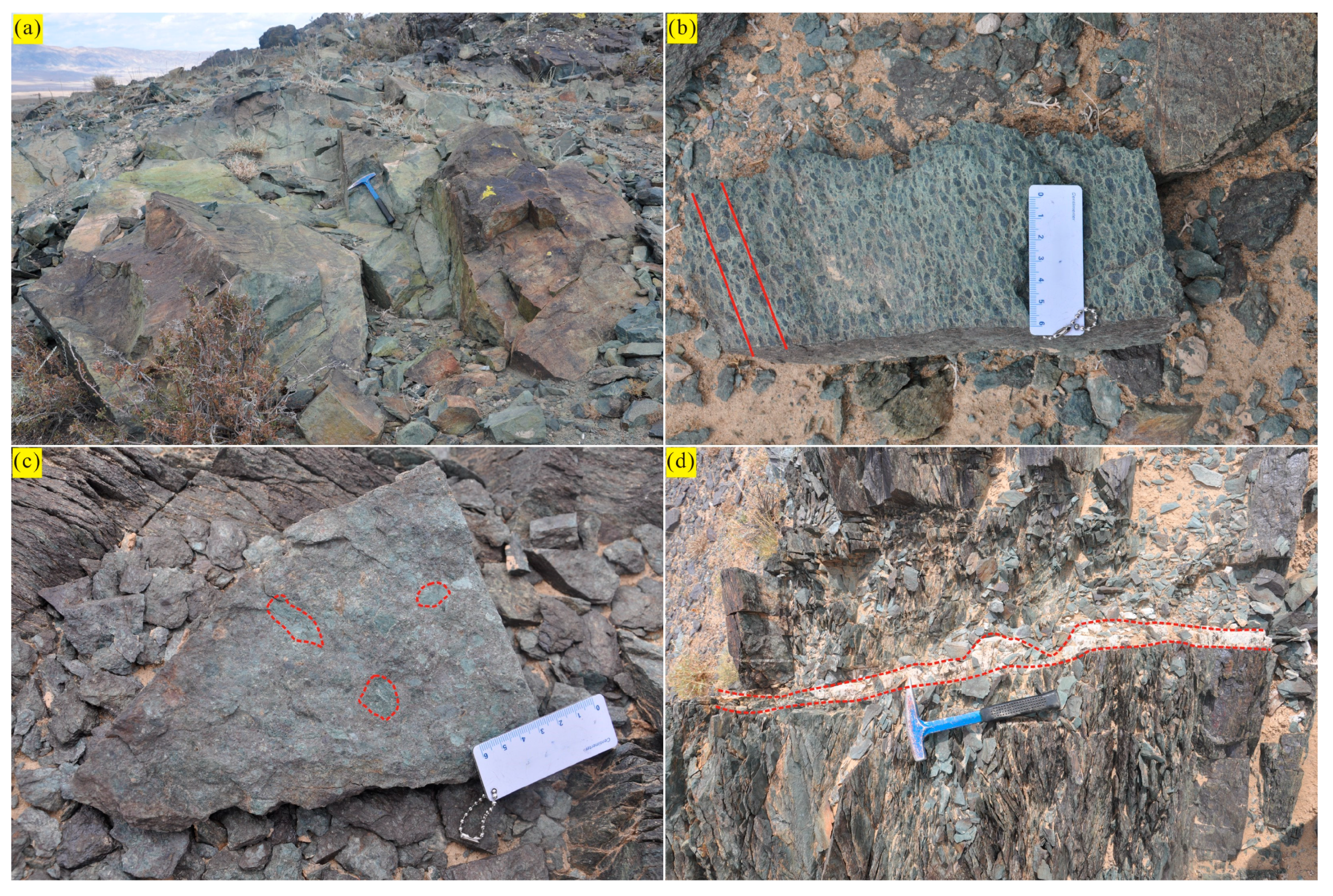
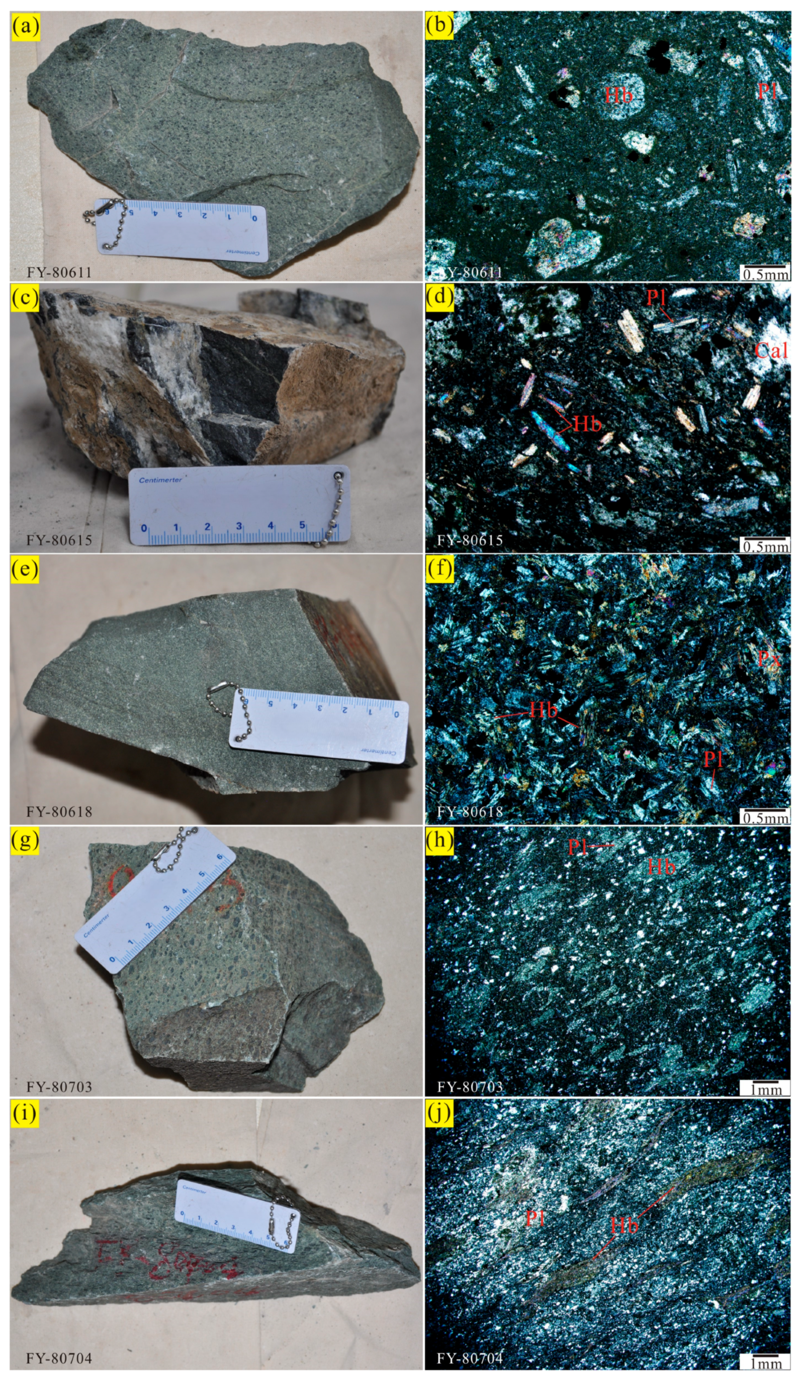
3. Volcanic Rock Geology and Sample Characteristics

Volcanic rocks and pyroclastic rocks are widely distributed in the Fuyun–Qinghe area and its vicinity. Volcanic rocks are found in thick layers in the field, primarily belonging to the Beitashan Formation as defined by previous researchers. Some parts of the rocks have undergone significant alteration, while the majority remain relatively fresh. Alteration is characterized by epidotization and chloritization (Figure 3a), a common phenomenon in the study region, particularly developed in mining areas such as the Qiaoxiahala and Laoshankou deposits. Volcanic rocks near the Ulungu River and the Qiaoxiahala mining area exhibit obvious orientations and developed cleavages. In the Qiaoxiahala mining area, strong cleavage and pronounced orientation are evident in the wall rocks where they contact the volcanic rocks. Although the overall deformation of the volcanic rocks is not pronounced, they exhibit a clear orientation. The overall degree of weathering is relatively weak, while epidotization alteration is pronounced. Closer to the ore body, the alteration becomes more severe, with heavier epidotization on rock fracture or joint surfaces. Away from the ore body or mineralization sites, epidotization is still present but much weaker. This suggests that the formation of the deposit was accompanied by fluids or hydrothermal solutions rich in epidotization. Additionally, some volcanic rocks contain relatively fresh diorite porphyry or diabase porphyry veins, which also exhibit epidotization. There is no distinct condensation or baking edge where the vein rocks contact the volcanic rocks, indicating that the vein rocks formed concurrently or slightly earlier than the orebody but later than the volcanic rocks. Local volcanic rocks include xenoliths, where epidotes are notably abundant, even forming individual rocks. Therefore, it is speculated that the volcanic rocks in this area originated from marine eruptions.
On the north bank of the Ulungu River, near Kurt town, numerous directionally aligned hornblende grains appear in the phenocrysts of volcanic rocks. Some hornblende grains exhibit elongation (Figure 3b), with phenocryst particles becoming progressively larger towards the south. Breccia is present in certain volcanic rocks (Figure 3c), and quartz veins are visible in the cleavage zones (Figure 3d).
The collected samples primarily consist of basaltic to andesitic volcanic rocks and pyroclastic rocks (Figure 4). Some sample characteristics are described as follows:
Sample FY-80611, basalt (named from field and petrography, hereinafter the same), was collected from the hillside behind the eastern mining pit in the Qiaoxiahala mining area, Fuyun County (N46°48′60″, E89°38′39″). The basalt is blue-gray in color and exhibits a porphyritic texture and a massive structure (Figure 4a). The phenocrysts are mainly hornblende (~8%, 0.5~1.5 mm), with long plate-like plagioclase (~10%, 0.3~1.5 mm), and a small amount of pyroxene (~5%, 0.5 mm). The hornblende grains are euhedral and long columnar in shape, and show chloritization, while the plagioclase grains are euhedral to subhedral and have undergone sericitization and kaolinization. The groundmass shows tholeiitic texture and is composed of plagioclase microcrystals, hornblende microcrystals, opaque minerals, microcryptocrystalline grains, and glassy materials (Figure 4b).
Sample FY-80615, andesite, was collected from the same site as sample FY-80611. The andesite is dark gray in color, with calcite veins visible in the hand specimen. The sample exhibits a porphyritic texture and a massive structure (Figure 4c). Phenocrysts are mainly long columnar hornblende (~15%, 0.2~0.5 mm), with lath-shaped plagioclase (~10%, 0.5~1 mm), some of which show polysynthetic twins. Additionally, there are aggregates of calcite in this sample. The groundmass is composed of plagioclase microcrystals, opaque minerals, microcryptocrystalline grains, and glassy materials (Figure 4d).
Sample FY-80618, basalt, was also collected from the same site as sample FY-80611. The basalt is dark green in color and exhibits a porphyritic texture and a massive structure (Figure 4e). The phenocrysts are mainly short columnar pyroxene (~10%, 0.5~1.0 mm), long columnar hornblende (~20%, 0.2~0.5 mm), and long plate-like plagioclase (~20%, 0.3~0.7 mm). Some plagioclase grains show Carlsbad–albite twins and polysynthetic twins. The groundmass shows an intersertal texture and is composed of opaque minerals, microcryptocrystalline grains, and glassy materials (Figure 4f).
Sample FY-80703, andesite, was collected from the north bank of the Ulungur River, near Kurt town, with coordinates N46°28′38″, E89°07′06″. A schistosity belt developed in this region, with a cleavage attitude of 192°∠59°. The rock mass shows a dark brown weathered surface and a grayish-green fresh surface, containing a large number of hornblende phenocrysts (0.2~0.8 mm), which are elongated and oriented. Moreover, there are several quartz veinlets. The sample is greenish-gray in color, with a porphyritic texture and a massive structure (Figure 4g). The phenocrysts are mainly elongated hornblende grains and a small amount of plagioclase grains, with a content of about 20%. Hornblende phenocrysts are mostly elongated grains, with sizes of about 0.5~3 mm, and have undergone heavy chloritization. Plagioclase phenocrysts are about 0.2~1 mm and have also undergone sericitization. The groundmass shows an andesitic texture and is composed of microcrystalline plagioclases, microcrystalline hornblendes, and glassy materials (Figure 4h).
Sample FY-80704, andesite, was collected 30 m south of sample FY-80703. The hornblende phenocrysts here are more numerous and larger than those in sample FY-80703, also with orientation. Therefore, we speculated on a SW-NE direction compressive stress. The sample is greenish-gray in color and exhibits a porphyritic texture and a massive structure (Figure 4i). Phenocrysts are mainly hornblende and plagioclase, with a content of about 25%. Hornblende phenocrysts are deformed, and elongated grains have undergone chloritization and are about 2~5 mm in size. Plagioclase phenocrysts are about 0.2~1 mm and have undergone sericitization, and most grains are broken into particles. The groundmass shows an andesitic texture (Figure 4j).

4. Analytical Methods

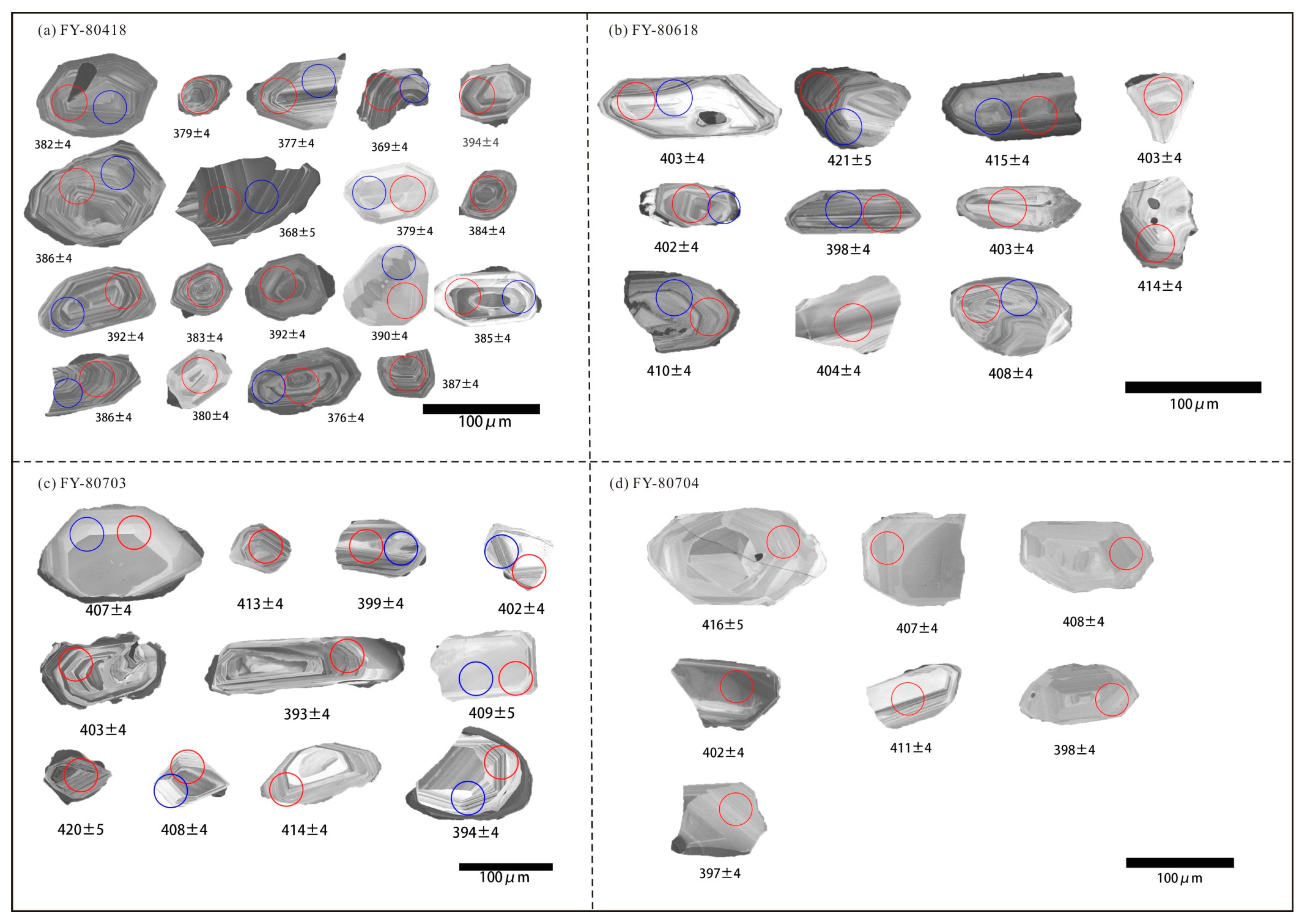
4.1. Zircon U–Pb Dating

Zircons were extracted from four samples (FY-80418, FY-80618, FY-80703, FY80704) by the Langfang Regional Geological Survey in Hebei Province, China. Standard density and magnetic separation methods were employed, after which zircon grains were manually selected under a binocular microscope. These grains were then analyzed using both transmitted and reflected light microscopy. To examine their internal structures and identify suitable targets for U-Pb dating, cathodoluminescence (CL) images were captured using a JEOL JSM6510 scanning electron microscope equipped with a GATAN Chroma CL detector at Gaonianlinghang Company in Beijing, China. U-Pb geochronological analysis was conducted using an LA-ICP-MS system located at the Inner Mongolia Geological Survey Institute in Hohhot, China. Zircon 91500 [50,51] was used as an external standard for age calibration Zircon standards GJ-1 [52] were analyzed as unknown samples that were inserted between 91500 and the samples, and NIST SRM 610 silicate glass was applied for instrument optimization. Detailed information on the instrument configurations and analytical protocols can be found in prior publications [53]. Corrections for common Pb were applied based on established methods [54], and Andersen [54] elaborated on a novel common lead correction method applicable to U-Pb analyses lacking 204Pb data. This approach determines the radiogenic lead content, total lead content, common lead proportion, initial crystallization age, lead loss age, and lead loss magnitude in zircon or other U/Th-rich minerals by numerically solving a set of equations. In this study, we implemented common lead corrections using the Excel spreadsheet tool provided by the authors in their original publication. Data reduction was performed using ICP–MS–DataCal (Ver. 6.7 [55]), and concordia diagrams were generated using Isoplot (Ver. 3.0; [56]).

4.2. Major and Trace Element Determinations

For whole-rock major and trace element analysis, the samples were initially crushed using a jaw crusher and subsequently pulverized to 200 mesh with an agate ball mill at the Langfang Regional Geological Survey in Hebei Province, China. The analyses of major and trace elements were conducted at ALS Chemex (Guangzhou, China) Co., Ltd. Major elements were measured using a Rigaku ZXS100e X-ray fluorescence spectrophotometer (XRF) (Tokyo, Japan), achieving an analytical precision of better than 2%. Trace elements were quantified using an Agilent 7500a (Agilent, Santa Clara, CA, USA) inductively coupled plasma–mass spectrometer (ICP-MS). To ensure accuracy, two standard reference materials (AGV-2 and GSR-1) were employed, with the analytical precision maintained within 5–10%.

4.3. Hf Isotope Analyses

In situ zircon Hf isotope measurements were conducted using a Neptune multi-collector–inductively coupled plasma–mass spectrometer (MC-ICP-MS) coupled with a GeoLas HD 193 nm laser ablation system at the Analysis and Testing Center of the Inner Mongolia Geological Survey Institute in Hohhot, China. The standard zircon 91500 [50,51,57] was utilized during the analyses. Comprehensive details regarding the analytical methodology and instrument parameters are provided in the work by Wu et al. [57].

5. Analytical Result

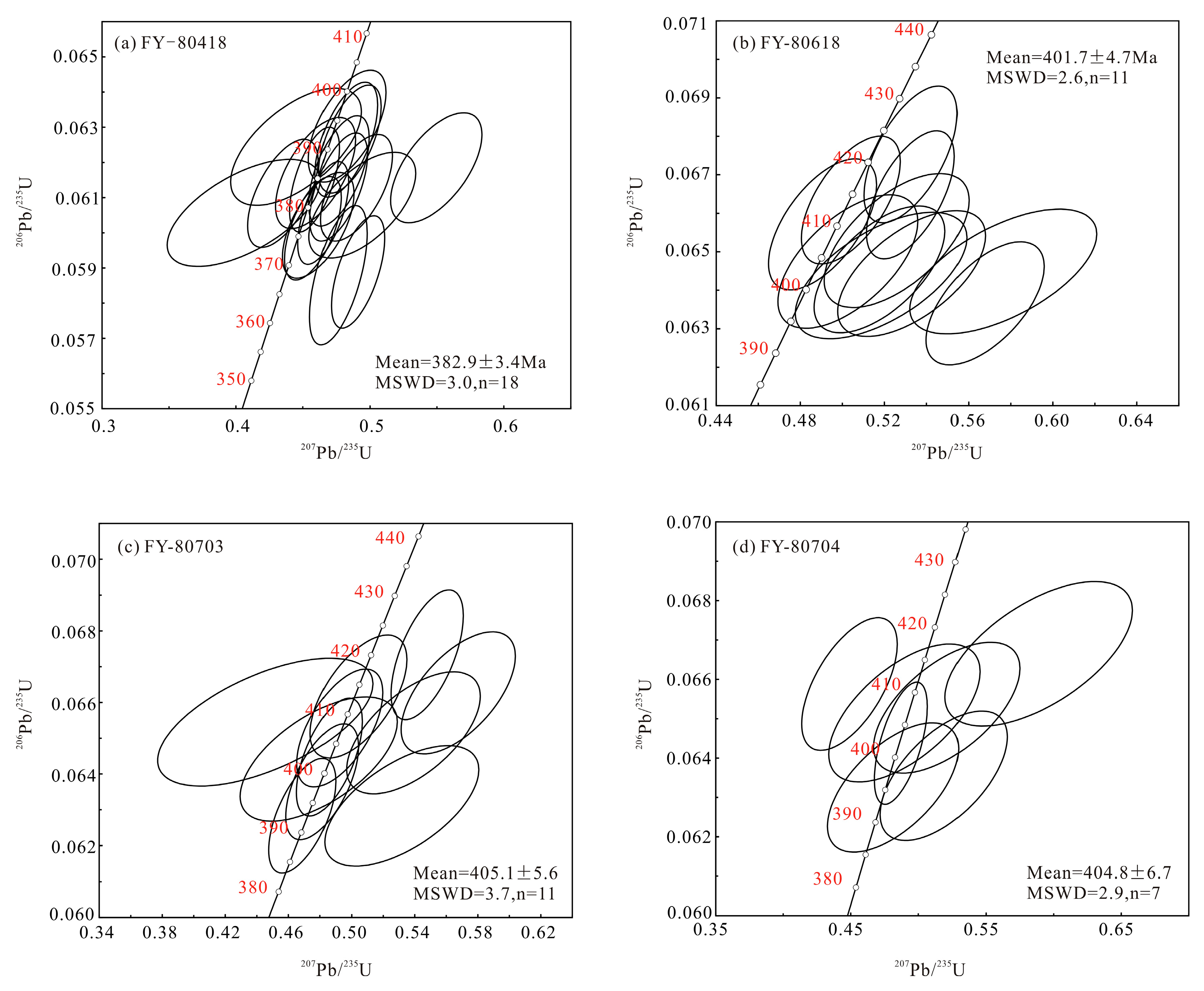
5.1. Zircon U–Pb Dating

This study presents the LA–ICP–MS zircon U–Pb dating results for four samples (FY-80418, FY-80618, FY-80703, FY80704) collected from the Fuyun–Qinghe area (see Table S1 for detailed results).
Sample FY-80418, a volcanic breccia. Twenty-nine zircon grains, ranging from 100 to 200 μm in length with length-to-width ratios of 1:1 to 2:1, were analyzed. These grains displayed euhedral to subhedral shapes and distinct oscillatory zoning in the cathodoluminescence (CL) images (Figure 5a). The Th and U concentrations varied from 10 to 914 ppm and 3 to 987 ppm, respectively, with Th/U ratios between 0.38 and 2.97 (excluding one outlier at 0.38), suggesting a magmatic origin [58]. The 206Pb/238U ages of 18 concordant spots ranged from 368 to 394 Ma, producing a weighted mean age of 382.9 ± 3.4 Ma (MSWD = 3.0), corresponding to the late Middle Devonian (Figure 6a).
For sample FY-80618, a basalt, 29 zircon grains were analyzed. These grains measured 50 to 150 μm in length, with length-to-width ratios of 1.5:1 to 2:1, and exhibited oscillatory zoning in the CL images (Figure 5b). The Th and U concentrations ranged from 51 to 1418 ppm and 83 to 1174 ppm, respectively, with Th/U ratios of 0.18 to 2.1 (mostly above 0.4). Eleven concordant spots yielded 206Pb/238U ages between 398 and 421 Ma, with a weighted mean age of 401.7 ± 4.7 Ma (MSWD = 2.6) (Figure 6b).
Sample FY-80703, an andesite, was analyzed using 15 zircon grains. The grains ranged from 50 to 200 μm in length, with length-to-width ratios of 1:1 to 3:1, and displayed oscillatory zoning in the CL images (Figure 5c). The Th and U concentrations varied from 57 to 277 ppm and 69 to 2236 ppm, respectively, with Th/U ratios of 0.09 to 1.26 (mostly exceeding 0.4, except for two points). Eleven concordant spots produced 206Pb/238U ages ranging from 393 to 420 Ma, yielding a weighted mean age of 405.1 ± 5.6 Ma (MSWD = 3.7), corresponding to the late Early Devonian (Figure 6c).
Lastly, sample FY-80704, also an andesite, was analyzed using 15 zircon grains. These grains measured 50 to 200 μm in length, with length-to-width ratios of 1:1 to 3:1, and exhibited oscillatory zoning in the CL images (Figure 5d). The Th and U concentrations ranged from 33 to 813 ppm and 56 to 758 ppm, respectively, with Th/U ratios of 0.44 to 1.26. Seven concordant spots yielded 206Pb/238U ages between 395 and 416 Ma, producing a weighted mean age of 404.8 ± 6.7 Ma (MSWD = 2.9) (Figure 6d).

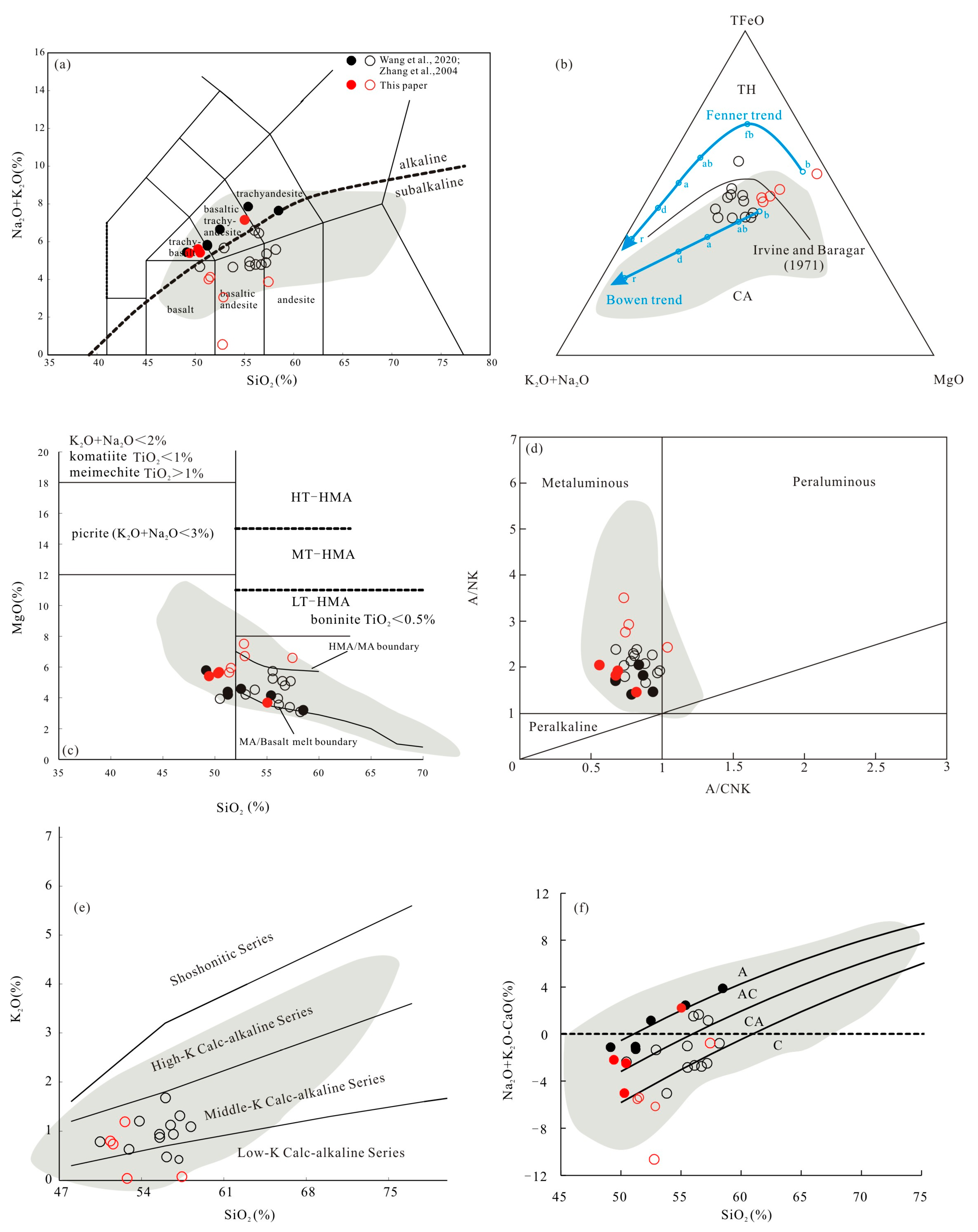
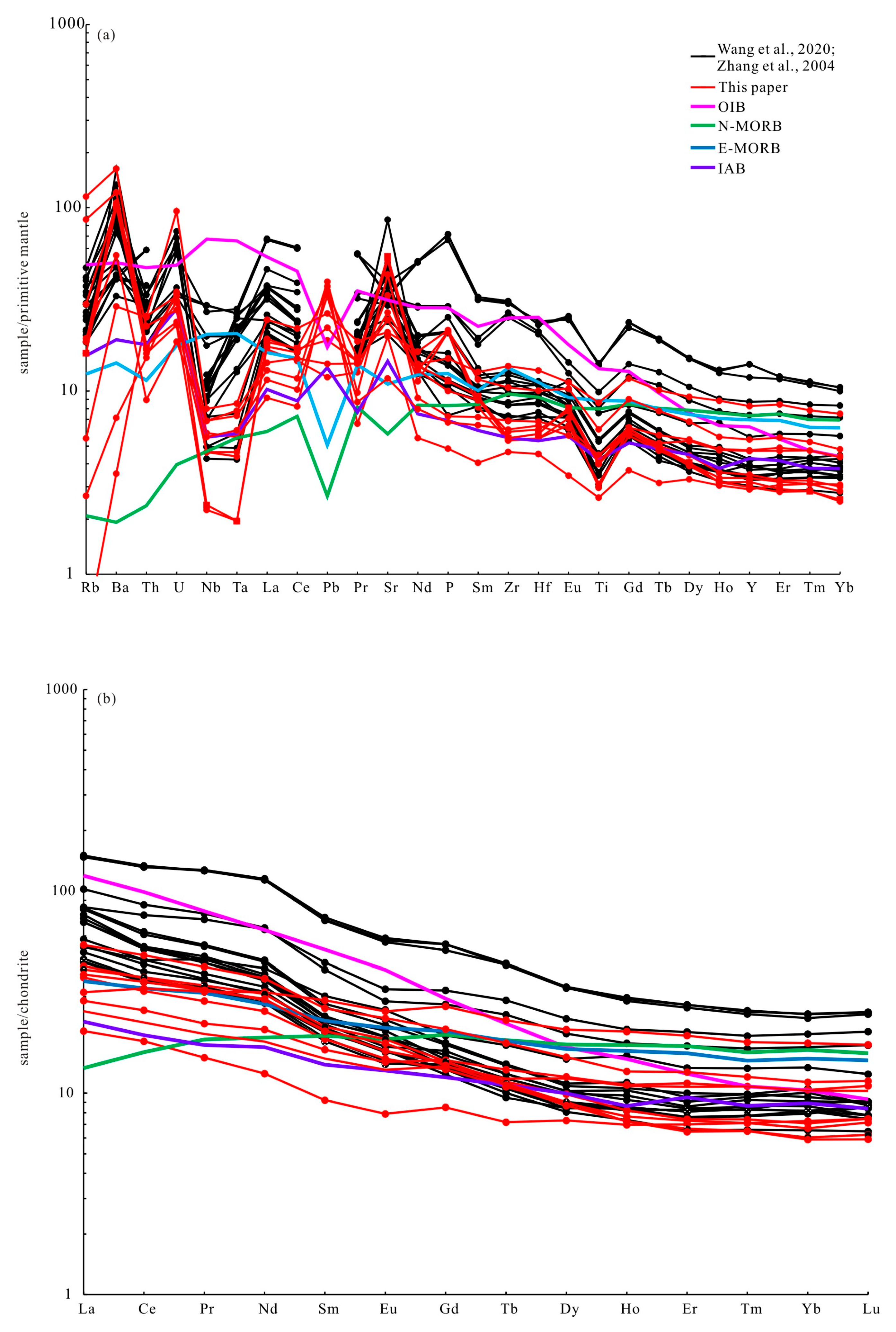
5.2. Major and Trace Elements

The major element data of the volcanic rocks are shown in Table S2. Among them, nine samples were collected from the Qiaoxiahala mining area and Kurt town on the north bank of the Ulungu River, and 18 samples were compiled from the literature [45,49]. All samples were Early–Middle Devonian intermediate to basic volcanic rocks. The samples were corrected for loss on ignition and volatile content, and the geochemical diagrams were constructed after normalizing the data to 100%.
The volcanic rocks showed SiO2 levels in the range of 42.79~57.22% (n = 27), with Na2O + K2O values of 0.52~7.74%; most samples had low K2O and high Na2O contents. Samples had CaO values of 3.59~11.5%, MgO values of 2.83~7.08% and Mg# values of 35.60~56.92. In a plot of Na2O + K2O versus SiO2 (Figure 7a), the samples were both subalkaline and alkaline series. Samples of the subalkaline series are mainly basaltic andesite and andesite, with little basalt. Samples of the alkaline series are mainly trachybasalt, basaltic trachyandesite, and trachyandesite. According to the recommendations of the IUGS, samples falling into trachybasalt, basaltic trachyandesite, and trachyandesite fields can be further divided based on whether their Na2O − 2 ≥ K2O. Therefore, samples of trachybasalt, basaltic trachyandesite, and trachyandesite can be further divided into hawaiite, potassic trachybasalt, mugearite, shoshonite, and benmoreite. From the above, in combination with the characteristics of field occurrence, hand specimens, and petrography, the specific rock names are shown in Table S2. In the AFM diagram, the subalkaline samples are mostly calc-alkaline series (Figure 7b). Alkaline series sample points are present as the basalt and MA series in the SiO2-MgO diagram, while most subalkaline samples are MA rocks, with a few HMA rocks (Figure 7c). In the A/CNK-A/NK diagram, all samples pertain to the metaluminous series rocks (Figure 7d). In the plot of K2O versus SiO2, the subalkaline samples belong to the low-K and middle-K CA series (Figure 7e). The alkaline samples (in the TAS diagram) in the SiO2-(Na2O + K2O − CaO) diagram show characteristics of A and AC series, while the subalkaline samples (in the TAS diagram) show AC, CA, and C series features (Figure 7f).
In addition, there were special labeled rock types such as sub-boninite (FY-80704, SiO2 = 54.36%, >52%, MgO = 6.24%, <8%, but higher than the boundary between HMA/MA, with 0.5% < TiO2 = 0.57% < 1%, so we define it as sub-boninite), adakite (A01-2, etc., SiO2 > 56%, Al2O3 ≥ 15%, MgO ≤ 6%, Sr ≥ 400 ppm, Y < 18 ppm), NEAB (FY-80618, etc., Na2O > K2O, TiO2 > 1%, Nb/La > 0.5, Nb/U > 10), and HMA and MA (see above).
We have also compiled the geochemical data of Neogene–Quaternary samples from the Taitao Island and southern Patagonian plateaus at the Chile Triple Junction. These samples were believed to be members of the igneous rocks of the magmatic arc formed by the Chile Ridge. The shaded fields in Figure 7 represent the ophiolitic and volcanic suites generated by Neogene to Quaternary ridge subduction and near-trench magmatism at the Chile Triple Junction, as well as the basaltic rocks of the Southern Patagonian plateau, which resulted from arc and back-arc magmatism linked to the Chile Ridge subduction. Upon comparison, it is evident that all samples presented in this research point within the compositional ranges of rocks formed by ridge subduction at the Chile Triple Junction (Figure 7). This indicates that the aforementioned rocks and their characteristics align perfectly with those of the rocks formed by the Chile mid-ocean ridge subduction.
The trace element compositions of the volcanic rocks are presented in Table S3. In a primitive mantle-normalized spider diagram (Figure 8a), both alkaline and subalkaline series exhibit enrichment in large-ion lithophile elements (LILEs, e.g., Rb, Ba, U, and Pb) and depletion in high-field-strength elements (HFSEs, e.g., Nb, Ta, and Ti). These patterns likely reflect the influence of subducting slab fluids and/or melt influx, as well as the metasomatism of the mantle source [23]. The depletion of Nb, Ta, and Ti suggests the presence of residual minerals such as hornblende and/or Fe–Ti oxides (e.g., rutile and ilmenite). The trends of most samples closely resemble those of the island arc basalts (IABs), characterized by enrichment in light rare earth elements (LREEs) and depletion in heavy rare earth elements (HREEs). The ΣLREE values range from 41.54 to 297.46 × 10⁻⁶, while ΣHREE values range from 8.93 to 42.09 × 10⁻⁶, with (La/Yb)N ratios between 1.79 and 8.49. The δEu values range from 0.85 to 1.10. When plotted on chondrite-normalized rare earth element patterns (Figure 8b), the samples show slight positive or negative Eu anomalies, with a positive Sr anomaly (Figure 8a) indicating minimal plagioclase fractionation during crystallization.

5.3. Zircon Hf Isotopes

In situ Hf isotope analysis was conducted on selected zircon U–Pb dating spots from samples FY-80418, FY-80618, FY-80703, and FY-80704 (Table S4). The primary zircons from these samples exhibited initial 176Hf/177Hf ratios ranging from 0.282671 to 0.283067. The corresponding εHf(t) values varied between +4.79 and +19.63, while the two-stage model ages (TDM2) spanned from 191 to 1060 Ma.

6. Discussion

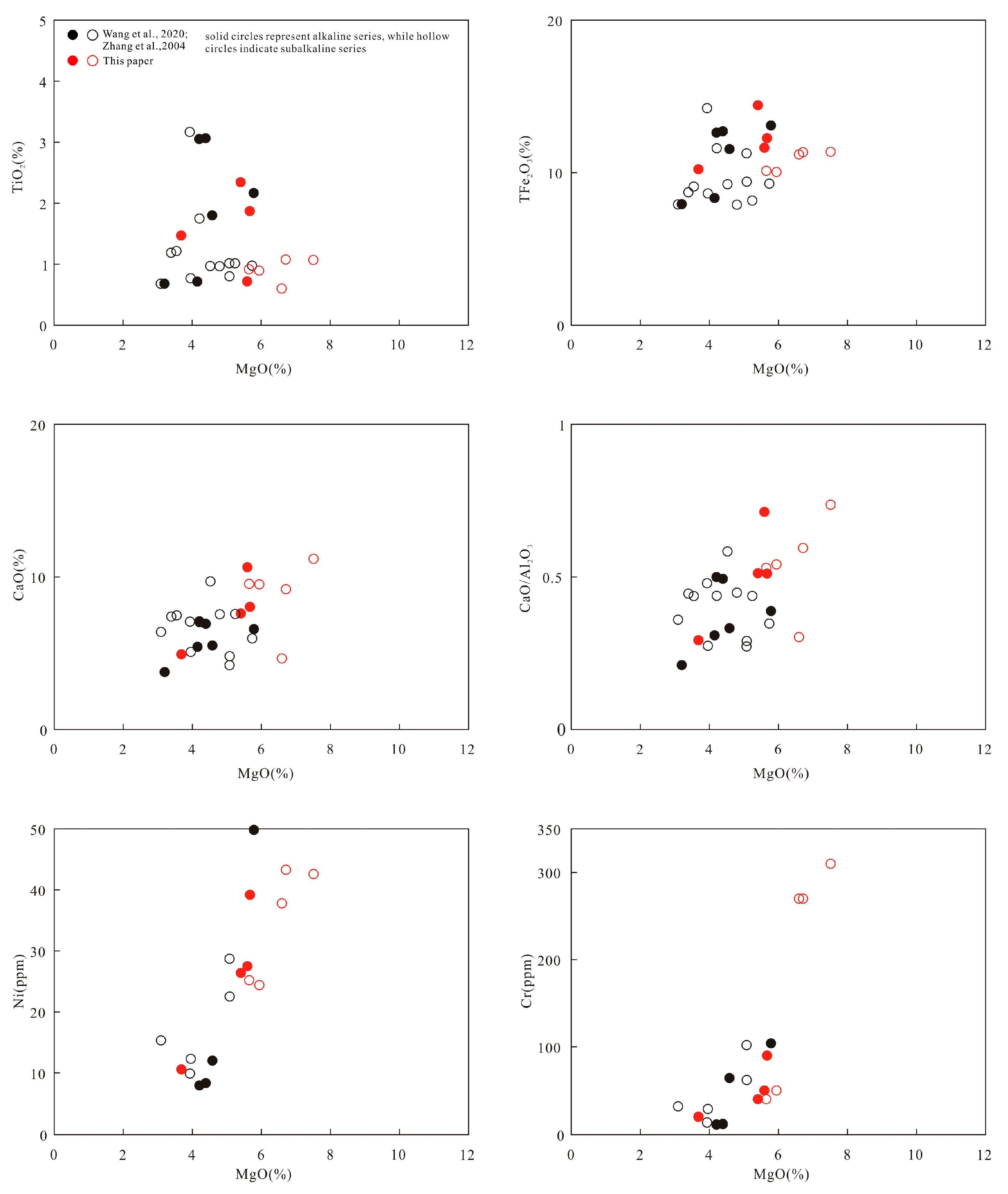
6.1. Crustal Contamination and Fractional Crystallization

The majority of the Early–Middle Devonian samples displayed elevated Nb/Ta and Nb/Th ratios, surpassing those typically associated with crustal-derived magmas [71,72]. These samples also exhibited low Rb/Sr ratios (0.0003–0.1064) and high Ti/Y ratios (223–431), further supporting the absence of significant crustal contamination [73]. Additionally, substantial crustal contamination would typically result in negative anomalies for Sr, P, and U in primitive mantle-normalized trace element diagrams [68]; however, the Early–Middle Devonian volcanic rocks in this study showed positive anomalies for these elements (Figure 8a). Collectively, these findings indicate that the Early–Middle Devonian volcanic rocks in the Fuyun–Qinghe area did not undergo extensive crustal contamination.
Regarding fractional crystallization, there was an inapparent correlation between MgO and TiO2 for both alkaline and subalkaline series rocks in the variation diagrams for major oxides and Cr, Ni, and MgO contents (Figure 9), and the correlations between MgO, TFe2O3, CaO, and CaO/Al2O3 of subalkaline samples (mostly CA rocks) were also not obvious. However, the alkaline series had obvious positive correlations. The aforementioned characteristics suggested that there had been no fractional crystallization in the CA series rocks; they might have undergone magmatic processes primarily characterized by varying degrees of partial melting or involved multiple magma sources. The relatively obvious correlations among some elements of the alkaline series rocks suggested a relatively consistent depth of magma sources, or they were subjected to fluid processes. Furthermore, a strong positive correlation was observed between Cr, Ni, and MgO, indicating the fractionation of the Cr-spinel (Figure 9).

6.2. Magma Sources and Petrogenesis

As mentioned earlier, the Early–Middle Devonian volcanic rock assemblages in the study area are hawaiite, mugearite, potassic trachybasalt, basaltic andesite, andesite, benmoreite, etc., which contain special labeled rocks such as adakite, sub-boninite, NEAB, HMA, and MA. Boninite forms through the high-degree partial melting of mantle peridotite under low-P and high-T conditions, facilitated by fluids enriched in incompatible elements derived from subducting oceanic crust [74]. In contrast, NEAB originates from the partial melting of a mantle wedge metasomatized by adakitic melts [75,76]. When subducting slab melts interact with mantle peridotite, they increase the Nb abundance and result in higher La/Yb ratios [2]. HMA, on the other hand, is generated by the partial melting of the mantle wedge above a subduction zone, driven by the release of H2O from the subducted oceanic crust [61]. In the P2O5 versus TiO2 and Nb/Yb versus Nb diagrams (Figure 10), samples of NEAB are present and fall within the slab melt metasomatism field. Similarly, in the primitive mantle-normalized Hf/Sm versus Ta/La diagram (Figure 11), some sample points align with fluid-related metasomatism or lie near the boundary between fluid- and melt-related metasomatism, indicating that the mantle peridotite was influenced by subducting fluids or melts. Furthermore, the subalkaline rocks are predominantly low-K to medium-K calc-alkaline series, characterized by a relatively high MgO content. Their enrichment in large-ion lithophile elements (LILEs) and depletion in high-field-strength elements (HFSEs) are consistent with the features of island arc magmatic rocks. In the primitive mantle-normalized trace element spider diagram (Figure 8a), the patterns of these samples closely resemble those of the island arc basalts (IABs). Consequently, it is evident that the Early–Middle Devonian volcanic rocks were formed in an arc environment associated with ocean subduction.
Experimental studies indicate that garnet preferentially retains heavy rare earth elements (HREEs) over middle rare earth elements during melting. As a result, melts derived from garnet–facies peridotite exhibit higher middle rare earth element/HREE ratios compared to those from spinel–facies peridotite [79]. The Sm/Yb ratios of basaltic rocks (including NEABs), HMAs, and sub-boninite from the Early–Middle Devonian volcanic rocks align with the melting curves of garnet–spinel mantle peridotite (Figure 12), suggesting that their precursor magma originated from 5–20% partial melting of enriched garnet–spinel lherzolite mantle. This is consistent with the relatively flat chondrite-normalized REE patterns, which are influenced by the presence of both spinel and garnet. Additionally, in a chondrite-normalized La/Sm versus Tb/Yb plot (Figure 13), basaltic samples and HMAs fall between the 5 and 10% partial melting curves of the primitive mantle and enriched mantle-20 fields [78], further supporting the idea that the precursor magma was generated by the partial melting of the enriched mantle. While the oceanic lithosphere typically exhibits depletion characteristics, the enriched mantle in this context likely reflects asthenospheric materials. This enrichment may have been triggered by the upwelling of asthenospheric materials through a slab window formed by the subduction of a spreading ridge.
It is noteworthy that some of these volcanic rocks displayed geochemical characteristics similar to those of MORB, such as low K and Ti, and high Al concentrations and high Zr/Hf ratios with low La/Yb ratios. In the plot of P2O5 versus TiO2, several sample points entered the deep mantle source region. In addition, our samples did not contain picrite, but picrite was also reported in the lower part of the Beitashan Formation in the southwest of Qinghe County by Zhang et al. [82]. Therefore, the Early–Middle Devonian rock assemblages in the Fuyun–Qinghe area also contained picrite. Picrite is the product of high-level melting of garnet peridotite metasomatized by fluid under high-temperature conditions [82]. Therefore, all the above rocks such as picrite, basalt, HMA, and their characteristics suggested that the asthenosphere mantle was another magma source.
Adakite and MA were also identified in the volcanic samples. Adakite primarily forms through two mechanisms: partial melting of young oceanic crust (less than 25 million years old) [83], due to its high heat flow units (HFUs, 2.8–8), or the partial melting of the thickened lower crust [84,85]. As previously noted, the study area was characterized by marine facies during the Early–Middle Devonian, eliminating the possibility of a thickened lower crust. Thus, the adakites in this region were likely generated by the subduction of young oceanic crust, which must have been younger than 25 Ma. Meanwhile, MA is thought to result from the interaction between magmas produced by the dehydration and melting of subducted oceanic crust and the overlying mantle wedge [86].
The discussions on fractional crystallization proved that the CA series rocks had different magma sources, and the εHf(t) and TDM2 of zircon varied widely, ranging from +4.79 to +18.26 and 191 to 1060 Ma, respectively, which also suggests the existence of different magma sources.
In summary, we believe that there were at least three magma sources for the volcanic rocks in the Fuyun–Qinghe area: young and hot subducted oceanic crust, overlying mantle wedge, and asthenosphere mantle.

6.3. Tectonic Setting

The tectonic setting of the Chinese Altay during the Devonian period remains a subject of debate. Wang et al. [87] linked the abrupt rise in the heat flux and geothermal gradient during the Early Devonian to the activation of thermal subduction mechanisms. Meng et al. [88] proposed that the Devonian volcanic rocks in the Ashele mining district were generated by mantle plume upwelling and slab break-off. Other researchers have argued that the Chinese Altay was situated in an arc environment, though the specific type of magmatic arc is still contested. Proposed models include the island arc [20,21], continental marginal arc [19,89,90], back-arc basin [22,91], forearc extension [92], and ridge subduction [2,3,23,24,93,94,95].
As mentioned earlier, the rock assemblages and geochemical characteristics of the volcanic rocks from the Early–Middle Devonian pointed to the features of arc rocks, indicating that there should be a tectonic setting and crust–mantle structure of the subduction zone. Furthermore, four of the collected samples exhibited (La/Yb)CN values of 1.9, 2.64, 2.94, and 2.97 (ranging from 1.3 to 3.4, indicating enrichment in LREEs compared to N-MORB), and (La/Nb)CN values of 2.02, 2.04, 1.85, and 1.83 (ranging from 1.2 to 2.35, indicating a depletion in HFSEs relative to LILEs and LREEs). These findings indicated that they belonged to E-MORB with a subduction-related imprint [26]. The remaining samples displayed a significant enrichment in LREEs and LILEs, along with a depletion in HFSEs, characteristic of arc magmatic rocks ((La/Yb)CN ranging from 4.20 to 9.04; (La/Nb)CN ranging from 2.09 to 7.66). In the Ti/100-Zr-Y*3 and Hf/3-Th-Ta triangle diagrams (Figure 14), the sample points predominantly fell within the CAB and MORB, as well as the CAB and E-MORB domains, further underscoring the dual characteristics of the Early–Middle Devonian volcanic rocks.
Numerous models have been proposed to explain the tectonic setting of igneous rocks exhibiting dual geochemical characteristics of both arc-like and MORB-like signatures. These include fore-arc basins, back-arc basins, decompression melting, asthenospheric upwelling due to slab break-off, and ridge subduction [3,17,22,23,26,95]. Fore-arc basalts are typically characterized by low LREE contents [74], with REE patterns resembling those of MORB. However, the samples in this study display LREE enrichment. Additionally, fore-arc basalts are generally associated with the initial stages of subduction, whereas subduction-related arc magmatism had already emerged during the Early Paleozoic in the Chinese Altay [46,98]. Furthermore, the presence of adakites in the Fuyun–Qinghe area during the same period suggests the partial melting of the young and hot oceanic crust [83], likely occurring on both sides of a slab window. The Kurt ophiolite on the southern margin of the Chinese Altay has been interpreted as a product of a back-arc basin [22]. However, distinctive rock types such as adakite, boninite, HMA, NEAB, picrite, and A-type granite also formed in this region during the Late Paleozoic [17,25,45]. Such diverse rock assemblages cannot be solely attributed to a cold and old back-arc basin. In the context of slab break-off, basaltic rocks typically exhibit affinities to both arc basalts and intraplate basalts, accompanied by rock assemblages such as intraplate basalts, A2-type siliceous rocks, and contemporaneous bimodal volcanic rocks [99]. Consequently, the geochemical features and rock assemblages of the Early–Middle Devonian volcanic rocks in the Fuyun–Qinghe area do not align with a slab break-off tectonic setting.
Ridge subduction can induce ridge–trench interaction and trigger asthenosphere upwelling through slab windows, resulting in particular rock assemblages and geochemical characteristics, such as adakites, NEABs, HMAs, boninites, A-type granites, bimodal volcanic rocks, picrites, and so on [25,30]. The Taitao Peninsula and Taitao Ridge from the Chile Triple Junction produced the most complete magma products related to ridge subduction from the Neogene to the Quaternary, which provided a typical example and abundant references for studying oceanic ridge subduction in the Chinese Altay. Guivel et al. [26] summarized six major ridge and near-trench magmatic activities in the Taitao Peninsula and Taitao Ridge. The four segments of the active oceanic ridge in southern Chile (Seg.1 → Seg.4) were mainly of the MORB type, while the Taitao Ridge was mainly of the MORB type with subduction imprints. In other words, calc-alkaline igneous rocks originated from the asthenosphere below the slab window and the subduction slab at the edge of the slab window. The igneous rocks from the Taitao Peninsula possessed both MORB and MORB with subduction imprint characteristics. The coexistence of the MORB type with subduction imprints and arc CA series rocks in the petrological–geochemical types is uncommon but arises from the ridge–trench interaction during active ridge subduction, plate divergence, and convergence. Similarly, Le Moigne et al. [65] investigated two Pliocene to Pleistocene volcanic–sedimentary units on the Taitao Peninsula, categorizing them into those with MORB affinities, CA (calc-alkaline) affinities, and intermediate characteristics. They proposed that the varying metamorphic overprints resulted from the collision of two distinct ridge segments with the South American margin near the Taitao Peninsula. Additionally, the Bahia Barrientos Ophiolite (BBO), associated with the subduction of the Chile Ridge, is also present in the Taitao Peninsula. The tectonic emplacement of the ophiolites occurred around the same time as the subduction of the Chile Ridge at approximately 6 Ma, with the Taitao Ridge being interpreted as a nascent ophiolite [26]. Our samples included adakite, NEAB, HMA, MA, and sub-boninite. Some of these rocks exhibited dual characteristics resembling both MORB-like and arc-like features, with the majority being calc-alkaline series rocks, which aligned with the subduction-imprinted MORB and typical calc-alkaline igneous suite found in the Taitao Ridge [26]. Our samples also contained alkaline basalts related to a slab window, potentially indicating the presence of alkaline plateau basalts associated with a deep slab window generated after the cessation stage of arc volcanism (or closer to back-arc position) [66]. In the Mayinebo Ophiolitic Mélange belt in the southern part of the study area, previous research had determined the zircon U-Pb ages of gabbros and a pillow basalt within the belt. The gabbros were formed at 404.6 ± 2.9 Ma and 403 ± 5 Ma, while the pillow basalt was formed at 397 ± 6 Ma [100,101], whose dating results closely align with the ages presented in this study. They might represent near-trench ophiolites analogous to BBO. Thus, the volcanic rock assemblages and characteristics in the Fuyun–Qinghe area during the Early–Middle Devonian were quite similar to those of the Taitao Ridge and Taitao Peninsula. Combined with the arc rock assemblages and characteristics and the three magma sources mentioned above, it is speculated that the Fuyun–Qinghe area, the southern margin of the Chinese Altay, could be in a tectonic setting of PAO ridge subduction, while predecessors called the ocean the Junggar Ocean.
The Chinese Altay also featured the presence of Alaska-type mafic–ultramafic complexes and dikes from the Devonian period (Early and Late Devonian) [2,23], and the Middle Devonian Beitashan Formation picrite was found in Qinghe County [82,102]. Furthermore, the Fuyun Supute area developed Middle Devonian Altay Formation bimodal volcanic rocks [103]. The Ashele Formation bimodal volcanic rocks, as well as the Early Devonian bimodal intrusive rocks in the Habahe area, are also significant [88]. The widespread occurrence of ~400 Ma granites with positive εHf(t) values, coupled with high-temperature, low-pressure metamorphism around 390 Ma [104], further supports the likelihood that the Chinese Altay was influenced by the PAO ridge subduction during the Devonian (see Figure 15).
Therefore, this paper proposes the following model, based on the current distribution of rock types and potential tectonic positions, and the research by Sisson et al. [31]. The nature of the PAO slab is illustrated in Figure 15 The rock types and potential tectonic positions encompassed adakite, which was formed on both sides of the slab window, mafic–ultramafic complexes and dikes resulting from near-trench magmatism, as well as nascent serpentinite, HMA, boninite, picrite, MA, adakite, NEAB, and A-type granite, all derived from complex magmatism during normal arc subduction. Additionally, there were bimodal magmatic rocks formed by back-arc magmatism and alkaline basalt, among others. These represent the magmatic activities occurring in various positions within the subduction zones during this period, including young oceanic crust subduction, mid-ocean ridge subduction, near-trench magmatism, and back-arc magmatism. However, more in-depth and detailed studies are needed on the scope of the ridge and the matching of its components, such as the spatial distribution of ophiolite, bimodal volcanic rocks, and even alkaline series and calc-alkaline series rocks. This study combines the collected samples with previous geological data to preliminarily map the spatial distribution of the Devonian igneous rocks related to ridge subduction in the Fuyun–Qinghe area (Figure 15). In the northwest, the region features Supute bimodal volcanic rocks, Kuerti back-arc basin ophiolites, and Maizi alkaline basalts generated by back-arc magmatism [22,103,105]. Moving southward, the region exhibits near-trench magmatic activities and slab window processes, manifested by picrites, boninites, HMA, nascent ophiolites, and A-type granites in areas such as Qiaoxiahala–Laoshankou–Buergen [25,82,100,101,106,107,108]. The spatial distribution pattern of the aforementioned igneous rocks suggests that the northwest portion of the study area experienced back-arc magmatism during this geological interval, whereas the southeastern region was situated in proximity to the trench and concurrent development of a slab window. The distributional characteristics of adakite and NEAB may indicate the edges of the developing slab window. Notably, the inferred locations of the mid-ocean ridge magmatic activity, which are primarily based on the current spatial distribution of volcanic rocks, may not fully represent the configuration of magmatic processes during this period. This discrepancy arises from potential post-magmatic tectonic reworking and/or the incomplete preservation of volcanic records in the study area.
Based on our research, we posit that during the Early–Middle Devonian, the Junggar Ocean, a branch of the PAO in the Fuyun–Qinghe area, experienced ridge subduction (we called it the Fuyun–Qinghe Ridge). We inferred that the Fuyun–Qinghe Ridge separated the Junggar Ocean into three plates from the current evidence, namely the central Fuyun–Qinghe Ridge, the western Junggar Ocean Plate, and the eastern Junggar Ocean Plate (Figure 15). The oceanic plates mentioned above were juvenile plates that had recently been pulled out from the Fuyun–Qinghe Ridge, and the juvenile oceanic plate also subducted and penetrated beneath the Altay orogenic belt along with the Fuyun–Qinghe Ridge. Due to the asymmetric expansion of the oceanic ridge, the subduction of the expanding ridge is an inevitable outcome of the closure of an ocean [109]. The Devonian ridge subduction in the Chinese Altay was similar to the ridge subduction on the east coast of the Pacific Ocean today. The scale of the Pacific Ocean is gradually decreasing nowadays, and the Junggar Ocean also gradually disappeared during the Devonian. Although the Junggar Ocean had a certain scale, it had entered the climax period of transition from ocean to continent and had moved towards a stage of accelerated extinction.
Due to the development of transform faults along mid-ocean ridges, the migration of magmatic arcs formed by ridge subduction along transform faults occurs in the present-day Chile Triple Junction (Taitao Ridge) subduction zone, with an estimated migration rate of approximately 100 km/Ma. In the Ashele mining district of the northwestern Chinese Altay, high-Mg dacites and basalts dated at ~403 Ma were developed, which formed in a slab window setting associated with ridge subduction [24]. However, during the late Early Devonian to Middle Devonian, slab window-related magmatic activities were predominantly distributed in the Fuyun-Qinghe area. We preliminarily propose that during the transition between the Early and Middle Devonian, the ridge and slab window migrated from the Ashele area in the northwest (approximately 400 km from the Fuyun-Qinghe area) to the Fuyun-Qinghe region. However, the specific details of this process require further in-depth research.

7. Conclusions

1. LA-ICP-MS zircon U-Pb dating of the volcanic rocks in the Fuyun–Qinghe area revealed that the basalt from the Qiaoxiahala mining area formed at 401.7 ± 4.7 Ma, while the andesites from Kurt town yielded ages of 405.1 ± 5.6 Ma and 404.8 ± 6.7 Ma. The volcanic breccia from Kurt town was dated to 382.9 ± 3.4 Ma. These results indicate that the rocks were formed during the Early–Middle Devonian.
2. The Early–Middle Devonian volcanic rocks in the Fuyun–Qinghe area have both alkaline and subalkaline series rocks in the TAS diagram, with rock assemblages including hawaiite, mugearite, potassic trachybasalt, basaltic andesite, andesite, benmoreite, etc., which contained special magmatic arc rock assemblages such as adakite, sub-boninite, NEAB, picrite, HMA, and MA. They were enriched in LILEs and depleted in HFSEs, exhibiting similar geochemical characteristics to the magmatic arc rocks formed by the Taitao Ridge subduction in Chile.
3. The basaltic rocks (including NEAB), sub-boninite, and HMA originated from the partial melting of garnet–spinel mantle peridotite metasomatized by subducted fluids (melts), with some rocks likely incorporating asthenospheric materials. In contrast, the MA and adakite were likely produced by the partial melting of the young and hot subducting oceanic crust (slab) and subsequent interaction with the mantle wedge peridotite.
4. The rock assemblages and petrogeochemical characteristics of Fuyun-Qinghe samples closely resemble those of the Taitao Ridge and Taitao Peninsula magmatic arc by the Taitao Ridge subduction during the Neogene–Quaternary period at the Chile Triple Junction. Based on these similarities, we propose that the Fuyun–Qinghe area was likely situated in a magmatic arc setting formed by the PAO ridge subduction during the Early–Middle Devonian.

Supplementary Materials

The following supporting information can be downloaded at https://www.mdpi.com/article/10.3390/app15073736/s1. Table S1: LA–ICP–MS zircon U–Pb dating data for the volcanic rocks in the Fuyun–Qinghe area; Table S2: Major (%) element data for the volcanic rocks in the Fuyun–Qinghe area; Table S3: Trace (ppm) element data for the volcanic rocks in the Fuyun–Qinghe area; Table S4: Lu-Hf isotopic data for the volcanic rocks in the Fuyun–Qinghe area.

Author Contributions

Conceptualization, J.L. and C.L.; writing, J.L.; review and editing, C.L. and Q.L.; supervision, Z.L. and Y.L.; investigation, J.L., C.Z., X.G., X.Y. and M.W. All authors have read and agreed to the published version of the manuscript.

Funding

This study was supported by the China Geological Survey Project (DD20221645, DD20190370, 1212011121075) and the National Natural Science Foundation of China (Grants No. 92162213 and 40802020).

Institutional Review Board Statement

Not applicable.

Informed Consent Statement

Not applicable.

Data Availability Statement

Data are contained within the article and Supplementary Materials.

Acknowledgments

We extend our gratitude to Meng Dai from AGRS and Tongyang Zhao from the Geological Survey Institute of Xinjiang Uygur Autonomous Region, China, for their support in field work and sample collection, and gratefully acknowledge the Inner Mongolia Geological Survey Institute for complimentary providing zircon geochronological analyses and testing services. Special appreciation is extended to Liquan Xu and Jianwei Xiao from the institute for their professional support throughout the analytical work, including sample testing procedures, data interpretation, and technical consultation. We also appreciate the insightful comments provided by the reviewers.

Conflicts of Interest

Author Chenghao Zhou was employed by the company China National Nuclear Corporation. The remaining authors declare that the research was conducted in the absence of any commercial or financial relationships that could be construed as a potential conflict of interest.

References

  1. Sengör, A.; Natal’in, B.; Burtman, V. Evolution of the Altaid tectonic collage and Paleozoic crustal growth in Asia. Nature 1993, 364, 299–307. [Google Scholar] [CrossRef]
  2. Cai, K.; Sun, M.; Yuan, C.; Zhao, G.; Xiao, W.; Long, X. Keketuohai mafic–ultramafic complex in the Chinese Altai, NW China: Petrogenesis and geodynamic significance. Chem. Geol. 2012, 294–295, 26–41. [Google Scholar] [CrossRef]
  3. Wang, Z.; Li, Y.; Yang, G.; Zhang, Y.; Li, H.; Zhao, Y.; Lindagato, P. Geochronology, geochemistry, and petrogenesis of the Kezijiaer gabbros, southern Chinese Altai: Evidence for ridge subduction. Geol. J. 2020, 55, 2254–2268. [Google Scholar] [CrossRef]
  4. Yang, G.; Li, Y.; Tong, L.; Wang, Z.; Si, G.; Lindagato, P.; Zeng, R. Natural observations of subduction initiation: Implications for the geodynamic evolution of the Paleo-Asian Ocean. Geosystems Geoenvironment 2022, 1, 100009. [Google Scholar] [CrossRef]
  5. Pan, G.; Lu, S.; Xiao, Q.; Zhang, K.; Yin, F.; Hao, G.; Luo, M.; Ren, F.; Yuan, S. Division of tectonic stages and tectonic evolution in China. Earth Sci. Front. 2016, 23, 10. [Google Scholar] [CrossRef]
  6. Xiao, W.J. Altaids, continental growth and metallogeny. Natl. Sci. Rev. 2023, 10, nwad004. [Google Scholar] [CrossRef]
  7. Gan, B.; Li, Z.; Song, Z.; Li, J. Middle Cambrian granites in the Dunhuang Block (NW China) mark the early subduction of the southernmost Paleo-Asian Ocean. Lithos 2020, 372–373, 105654. [Google Scholar] [CrossRef]
  8. Wang, E.; Zhai, X.; Chen, W.; Wu, L.; Song, G.; Wang, Y.; Guo, Z.; Zhao, J.; Wang, J. Late Devonian A-Type Granites from the Beishan, Southern Central Asia Orogenic Belt: Implications for Closure of the Paleo-Asia Ocean. Minerals 2023, 13, 565. [Google Scholar] [CrossRef]
  9. Niu, Y.; Shi, G.R.; Wang, J.; Liu, C.; Zhou, J.; Lu, J.; Song, B.; Xu, W. The closing of the southern branch of the Paleo-Asian Ocean: Constraints from sedimentary records in the southern Beishan Region of the Central Asian Orogenic Belt, NW China. Mar. Pet. Geol. 2021, 124, 104791. [Google Scholar] [CrossRef]
  10. Liu, Q.; Zhao, G.; Han, Y.; Eizenhöfer, P.R.; Zhu, Y.; Hou, W.; Zhang, X. Timing of the final closure of the Paleo-Asian Ocean in the Alxa Terrane: Constraints from geochronology and geochemistry of Late Carboniferous to Permian gabbros and diorites. Lithos 2017, 274–275, 19–30. [Google Scholar] [CrossRef]
  11. Weng, K.; Cao, J.; Karibovich, D.; Movlanov, J.; Chen, B.; Ma, Z. Zircon U-Pb ages in the Nuratau ophiolitic mélange in the southern Tianshan, Uzbekistan: Implication for the closure of Paleo-Asian Ocean. China Geol. 2024, 7, 365–368. [Google Scholar] [CrossRef]
  12. Duan, F.; Zhi, Q.; Xiao, W.; Li, Y. Late Palaeozoic final subduction records of the southwestern Paleo-Asian Ocean revealed by ca. 286–283 Ma basaltic rocks in the West Junggar, NW China. Int. Geol. Rev. 2023, 65, 3128–3145. [Google Scholar] [CrossRef]
  13. Liu, B.; Han, B.; Chen, J.; Ren, R.; Zheng, B.; Wang, Z.; Feng, L. Closure Time of the Junggar-Balkhash Ocean: Constraints From Late Paleozoic Volcano-Sedimentary Sequences in the Barleik Mountains, West Junggar, NW China. Tectonics 2017, 36, 2823–2845. [Google Scholar] [CrossRef]
  14. Xiao, W.; Han, C.; Yuan, C.; Sun, M.; Lin, S.; Chen, H.; Li, Z.; Li, J.; Sun, S. Middle Cambrian to Permian subduction-related accretionary orogenesis of Northern Xinjiang, NW China: Implications for the tectonic evolution of central Asia. J. Asian Earth Sci. 2008, 32, 102–117. [Google Scholar] [CrossRef]
  15. Song, D.; Xiao, W.; Ao, S.; Mao, Q.; Wan, B.; Zeng, H. Contemporaneous closure of the Paleo-Asian Ocean in the Middle-Late Triassic: A synthesis of new evidence and tectonic implications for the final assembly of Pangea. Earth-Sci. Rev. 2024, 253, 104771. [Google Scholar] [CrossRef]
  16. Wang, H.; Xiao, W.; Li, R.; Chen, H.; Tan, Z.; Mao, Q.; Shi, M. High-grade complexes record the Late Permian-Middle Triassic arc metamorphism in the southernmost Altaids: Implications for the final closure of the Paleo-Asian Ocean. Lithos 2023, 442–443, 107054. [Google Scholar] [CrossRef]
  17. Niu, H.; Sato, H.; Zhang, H.; Ito, J.I.; Yu, X.; Nagao, T.; Terada, K.; Zhang, Q. Juxtaposition of adakite, boninite, high-TiO2 and low-TiO2 basalts in the Devonian southern Altay, Xinjiang, NW China. J. Asian Earth Sci. 2006, 28, 439–456. [Google Scholar] [CrossRef]
  18. Xu, Q.; Li, Y.; Yang, G.; Ning, W.; Tong, L.; Duan, F.; Wu, L.; Ren, P.; Xiao, W. Petrogenesis and tectonic setting of the Middle Devonian Beitashan Formation volcanic rocks in the northern East Junggar, NW China: Insights from geochemistry, zircon U–Pb dating, and Hf isotopes. Geol. J. 2019, 55, 1964–1983. [Google Scholar] [CrossRef]
  19. Zheng, J.; Chai, F.; Yang, F. The 401–409 Ma Xiaodonggou granitic intrusion: Implications for understanding the Devonian Tectonics of the Northwest China Altai orogen. Int. Geol. Rev. 2015, 58, 540–555. [Google Scholar] [CrossRef]
  20. Zhang, Z.; Zhou, G.; Kusky, T.M.; Yan, S.; Chen, B.; Zhao, L. Late Paleozoic volcanic record of the Eastern Junggar terrane, Xinjiang, Northwestern China: Major and trace element characteristics, Sr–Nd isotopic systematics and implications for tectonic evolution. Gondwana Res. 2009, 16, 201–215. [Google Scholar] [CrossRef]
  21. Liang, P.; Chen, H.; Hollings, P.; Xiao, B.; Wu, C.; Bao, Z.; Cai, K. The Paleozoic tectonic evolution and metallogenesis of the northern margin of East Junggar, Central Asia Orogenic Belt: Geochronological and geochemical constraints from igneous rocks of the Qiaoxiahala Fe-Cu deposit. J. Asian Earth Sci. 2016, 130, 23–45. [Google Scholar] [CrossRef]
  22. Xu, J.; Chen, F.; Yu, X.; Niu, H.; Zheng, Z.P. Kuerti ophiolite in Altay area of north Xinjiang: Magmatism of an ancient back-arc basin. Acta Petrol. Mineral. 2001, 20, 344–352. [Google Scholar]
  23. Cai, K.; Sun, M.; Yuan, C.; Zhao, G.; Xiao, W.; Long, X.; Wu, F. Geochronological and geochemical study of mafic dykes from the northwest Chinese Altai: Implications for petrogenesis and tectonic evolution. Gondwana Res. 2010, 18, 638–652. [Google Scholar] [CrossRef]
  24. Wu, Y.; Yang, F.; Liu, F.; Geng, X.; Li, Q.; Zheng, J. Petrogenesis and tectonic settings of volcanic rocks of the Ashele Cu–Zn deposit in southern Altay, Xinjiang, Northwest China: Insights from zircon U–Pb geochronology, geochemistry and Sr–Nd isotopes. J. Asian Earth Sci. 2015, 112, 60–73. [Google Scholar] [CrossRef]
  25. Shen, X.; Zhang, H.; Wang, Q.; Wyman, D.A.; Yang, Y. Late Devonian–Early Permian A-type granites in the southern Altay Range, Northwest China: Petrogenesis and implications for tectonic setting of “A2-type” granites. J. Asian Earth Sci. 2011, 42, 986–1007. [Google Scholar] [CrossRef]
  26. Guivel, C.; Lagabrielle, Y.; Bourgois, J.; Maury, R.C.; Fourcade, S.; Martin, H.; Arnaud, N. New geochemical constraints for the origin of ridge-subduction-related plutonic and volcanic suites from the Chile Triple Junction (Taitao Peninsula and Site 862, LEG ODP141 on the Taitao Ridge). Tectonophysics 1999, 311, 83–111. [Google Scholar] [CrossRef]
  27. Lagabrielle, Y.; Guivel, C.; Maury, R.C.; Bourgors, J.; Fourcade, S.; Martin, H. Magmatic tectonic effects of high thermal regime at the site of active ridge subduction: The Chile Triple Junction model. Tectonophysics 1996, 326, 255–268. [Google Scholar] [CrossRef]
  28. Cole, R.B.; Stewart, B.W. Continental margin volcanism at sites of spreading ridge subduction: Examples from southern Alaska and western California. Tectonophysics 2009, 464, 118–136. [Google Scholar] [CrossRef]
  29. Liu, X.; Xiao, W.; Xiao, Y.; Liu, P.; Song, Y.; Huang, W.; Zhang, Z.; Liu, X. The major characteristics of ridge subduction in the Central Asian Orogenic Belt and their research advances. Geochimica 2025, 54, 3–23. [Google Scholar]
  30. Shen, X.; Zhang, H.; Ma, L. Ridge Subduction and the Possible Evidences in Chinese Altay, Xinjiang. Geotecton. Metallog. 2010, 34, 181–195. [Google Scholar]
  31. Sisson, V.B.; Pavlis, T.L.; Roeske, S.M.; Thorkelson, D.J. Introduction: An overview of ridge-trench interactions in modern and ancient settings. In Geological Society of America Special Paper; Geological Society of America: Boulder, CO, USA, 2003; Volume 371, pp. 1–18. [Google Scholar] [CrossRef]
  32. Windley, B.F.; Kröner, A.; Guo, J.; Qu, G.; Li, Y.; Zhang, C. Neoproterozoic to Palaeozoic geology of the Altai orogen, NW China: New zircon age data and tectonic evolution. J. Geol. 2002, 110, 719–737. [Google Scholar]
  33. Wang, T.; Jahn, B.; Kovach, V.P.; Tong, Y.; Wilde, S.A.; Hong, D.; Li, S.; Salnikova, E.B. Mesozoic intraplate granitic magmatism in the Altai accretionary orogen, NW China: Implications for the orogenic architecture and crustal growth. Am. J. Sci. 2014, 314, 1–42. [Google Scholar] [CrossRef]
  34. XUARGSI (Xinjiang Uygur Autonomous Region Geological Survey Institute). Regional Geological Annals of Xinjiang Uygur Autonomous Region; Xinjiang Uygur Autonomous Region Geological Survey Institute: Urumqi, China, 2021. [Google Scholar]
  35. Wang, T.; Tong, Y.; Jahn, B.; Zou, T.; Wang, Y.; Hong, D.; Han, B. SHRIMP U–Pb Zircon geochronology of the Altai No. 3 Pegmatite, NW China, and its implications for the origin and tectonic setting of the pegmatite. Ore Geol. Rev. 2007, 32, 325–336. [Google Scholar] [CrossRef]
  36. Zhang, C.; Liu, L.; Santosh, M.; Luo, Q.; Zhang, X. Sediment recycling and crustal growth in the Central Asian Orogenic Belt: Evidence from Sr–Nd–Hf isotopes and trace elements in granitoids of the Chinese Altay. Gondwana Res. 2017, 47, 142–160. [Google Scholar] [CrossRef]
  37. Liang, P.; Chen, H.; Wu, C.; Liu, Z. Geochemistry, geochronology and oxygen fugacity of volcanic and intrusive rocks from the Laoshankou Fe–Cu–Au deposit in the northern margin of East Junggar, NW China. Earth Sci. Front. 2018, 25, 96–118. [Google Scholar] [CrossRef]
  38. Shen, X.; Zhang, H.; Wang, Q.; Ma, L.; Yang, Y. Early Silurian (~440 Ma) adakitic, andesitic and Nb-enriched basaltic lavas in the southern Altay Range, Northern Xinjiang (western China): Slab melting and implications for crustal growth in the Central Asian Orogenic Belt. Lithos 2014, 206–207, 234–251. [Google Scholar] [CrossRef]
  39. Zhang, H.; Shen, X.; Ma, L.; Niu, H.; Yu, X. Geochronologyy of the Fuyun adakite, north Xinjiang and its constraint to the initiation of the Paleo-Asian Ocean subduction. Acta Petrol. Sin. 2008, 24, 1054–1058. [Google Scholar]
  40. Dong, Z. Paleozoic Geological Evolution of the Chinese Altai Orogen in the Fuyun-Qinghe Region: Constraints on the Accretionary Orogenic Processes of the Paleo-Asian Ocean. Doctoral Dissertation, Northwest University, Xi’an, China, 2020. [Google Scholar]
  41. Geng, X.; Yang, F.; Qin, J.; Wen, C. Devonian porphyry Cu deposits in NW China: The Xiaotuergen example. Int. Geol. Rev. 2016, 59, 1219–1233. [Google Scholar] [CrossRef]
  42. Li, Q.; Lv, S.; Yang, F.; Geng, X.; Chai, F. Geological characteristics and genesis of the Laoshankou Fe–Cu–Au deposit in Junggar, Xinjiang, Central Asian Orogenic Belt. Ore Geol. Rev. 2015, 68, 59–78. [Google Scholar] [CrossRef]
  43. Yang, T.N.; Li, J.Y.; Zhang, J.; Hou, K.J. The Altai-Mongolia terrane in the Central Asian Orogenic Belt (CAOB): A peri-Gondwana one? Evidence from zircon U–Pb, Hf isotopes and REE abundance. Precambrian Res. 2011, 187, 79–98. [Google Scholar] [CrossRef]
  44. Chai, F.; Yang, F.; Liu, F.; Geng, X.; Lv, S.; Jiang, L.; Zang, M.; Chen, B. Geochronology and genesis of volcanic rocks in Beitashan Formation at the northern margin of the Junggar, Xinjiang. Acta Petrol. Sin. 2012, 28, 2183–2198. [Google Scholar]
  45. Zhang, H.; Niu, H.; Sato, H.; Shan, Q.; Yu, X.; Ito, J.; Zhang, Q. Late Paleozoic adakite and Nb-enriched basalt from northern Xinjiang: Evidence for the southward subduction of the Paleo-Asian Ocean. Geol. J. China Univ. 2004, 10, 106–113. [Google Scholar]
  46. Zhang, C.; Liu, D.; Zeng, J.; Jiang, S.; Luo, Q.; Kong, X.; Yang, W.; Liu, L. Nd-O-Hf isotopic decoupling in S-type granites: Implications for ridge subduction. Lithos 2019, 332–333, 261–273. [Google Scholar] [CrossRef]
  47. Lv, S.; Yang, F.; Chai, F.; Zhang, X.; Jiang, L.; Liu, F.; Zhang, Z.; Geng, X.; Ouyang, L. Zircon U-Pb dating for intrusions in Laoshankou ore district in Northern margin of East Junggar and their significances. Geol. Rev. 2012, 58, 149–164. [Google Scholar]
  48. Chu, F.; Zhao, T.; Zhang, J.; Zhu, Z.; Tang, Z.; Yan, X. Geochemical Characteristics and Geochronology of Sherbulake Ophiolite in Xinjiang. Xinjiang Geol. 2013, 31, 167–172. [Google Scholar]
  49. Wang, Y.; Zhu, Z.; Li, X.; Li, P.; Zheng, F.; Gong, X. The SHRIMP Zircon U-Pb dating of the volcanic rocks of the Tuoranggekuduke Formation in the Early Devonian, Eastern Junggar and geological implications. Xinjiang Geol. 2020, 38, 161–167. [Google Scholar]
  50. Wiedenbeck, M.; Allé, P.; Corfu, F.; Griffin, W.; Meier, M.; Oberli, F.; Vonquat, A.; Roddick, J.; Spiegel, W. Three natural zircon standards for U-Th-Pb, Lu-Hf, tracelement and ree analyse. Geostand. Newsl. 1995, 19, 1–23. [Google Scholar] [CrossRef]
  51. Wiedenbeck, M.; Hanchar, J.; Peck, W.; Sylvester, P.; Valley, J.; Whitehouse, M.; Kronz, A.; Morishita, Y.; Nasdala, L.; Fiebig, J.; et al. Further characterisation of the 91500 zircon crystal. Geostand. Geoanalytical Res. 2004, 28, 9–39. [Google Scholar] [CrossRef]
  52. Jackson, S.; Pearson, N.; Griffin, W.; Belousova, E. The application of laser ablation-inductively coupled plasma-mass spectrometry to in situ U–Pb zircon geochronology. Chem. Geol. 2004, 211, 47–69. [Google Scholar] [CrossRef]
  53. Zhang, L.; Zhu, D.; Wang, Q.; Zhao, Z.; Liu, D.; Xie, J. Late Cretaceous Volcanic Rocks in the Sangri Area, Southern Lhasa Terrane, Tibet: Evidence for Oceanic Ridge Subduction. Lithos 2019, 326–327, 144–157. [Google Scholar] [CrossRef]
  54. Anderson, T. Correction of common Lead in U–Pb analyses that do not report 204Pb. Chem. Geol. 2002, 192, 59–79. [Google Scholar] [CrossRef]
  55. Liu, Y.S.; Hu, Z.C.; Gao, S.; Günther, D.; Xu, J.; Gao, C.G.; Chen, H.H. In Situ Analysis of Major and Trace Elements of Anhydrous Minerals by LA–ICP–MS without Applying an Internal Standard. Chem. Geol. 2008, 257, 34–43. [Google Scholar] [CrossRef]
  56. Ludwig, K.R. ISOPLOT 3: A geochronological toolkit for microsoft excel. Berkeley Geochronol. Cent. Spec. Publ. 2003, 4, 74. [Google Scholar]
  57. Wu, F.; Yang, Y.; Xie, L.; Yang, J.; Xu, P. Hf isotopic compositions of the standard zircons and baddeleyites used in U–Pb geochronology. Chem. Geol. 2006, 234, 105–126. [Google Scholar] [CrossRef]
  58. Wu, Y.; Zheng, Y. Zircon Genetic Mineralogy and Its Constraints on U–Pb Age Interpretation. Chin. Sci. Bull. 2004, 49, 1589–1604. [Google Scholar] [CrossRef]
  59. Le Bas, M.; Le Maitre, R.; Streckeisen, A.; Zanettin, B. A chemical classification of volcanic rocks based on the total alkali–silica diagram. J. Petrol. 1986, 27, 745–750. [Google Scholar] [CrossRef]
  60. Irvine, T.N.; Baragar, W.R.A. A Guide to the Chemical Classification of the Common Volcanic Rocks. Can. J. Earth Sci. 1971, 8, 523–548. [Google Scholar] [CrossRef]
  61. Deng, J.; Flower, M.F.J.; Liu, C.; Mo, X.; Su, S.; Wu, Z. Nomeuclature, diagnosis and origin of high-magnesian andesites (HMA) and magnesian andesites (MA): A review from petrographic and experimental data. Geochim. Cosmochim. Acta 2009, 73, A279. [Google Scholar]
  62. Maniar, P.D.; Piccoli, P.M. Tectonic Discrimination of Granitoids. Geol. Soc. Am. Bull. 1989, 101, 635–643. [Google Scholar] [CrossRef]
  63. Peccerillo, R.; Taylor, S.R. Geochemistry of Eocene Calc-Alkaline Volcanic Rocks from the Kastamonu Area, Northern Turkey. Contrib. Mineral. Petrol. 1976, 58, 63–81. [Google Scholar] [CrossRef]
  64. Frost, B.R.; Barnes, C.G.; Collins, W.J.; Arculus, R.J.; Ellis, D.J.; Frost, C.D. A Geochemical Classification for Granitoids Rocks. J. Petrol. 2001, 42, 2033–2048. [Google Scholar] [CrossRef]
  65. Le Moigne, J.; Lagabrielle, Y.; Whitechurch, H.; Girardeau, J.; Bourois, J.; Maury, R. Petrology and geochemistry of the Ophiolitic and Volcanic Suites of the Taitao Peninsula–Chile Triple Junction Area. J. S. Am. Earth Sci. 1996, 9, 43–58. [Google Scholar]
  66. Ramos, V.A.; Kay, S.M. Southern Patagonian plateau basalts and deformation: Backarc testimony of ridge collisions. Tectonophysics 1992, 205, 261–282. [Google Scholar]
  67. Boynton, W.V. Geochemistry of the rare earth elements: Meteorite studies. In Rare Earth Element Geochemistry; Henderson, P., Ed.; Elsevier: Amsterdam, The Netherlands, 1984; pp. 63–114. [Google Scholar]
  68. Sun, S.; McDonough, W.F. Chemical and isotopic systematics of ocneanic basalts: Implications for mantle composition and processes. In Magmatism in Ocean Basins; Saunders, A.D., Norry, M.J., Eds.; Geological Society of Special Publication: London, UK, 1989; pp. 313–345. [Google Scholar]
  69. Niu, Y.; O’Hara, M.J. Origin of ocean island basalts: A new perspective from petrology, geochemistry, and mineral physics considerations. J. Geophys. Res. Solid Earth 2003, 108, 2209. [Google Scholar] [CrossRef]
  70. Kelemen, P.B.; Hanghøj, K.; Greene, A.R. One View of the Geochemistry of Subduction-Related Magmatic Arcs, with an Emphasis on Primitive Andesite and Lower Crust. Treatise Geochem. Second Ed. 2014, 4, 749–806. [Google Scholar] [CrossRef]
  71. Green, T.H. Significance of Nb/Ta as an indicator of geochemical processes in the crust–mantle system. Chem. Geol. 1995, 120, 347–359. [Google Scholar] [CrossRef]
  72. Rudnick, R.L.; Gao, S. Composition of the continental crust. Treatise Geochem. 2003, 3, 1–64. [Google Scholar]
  73. Han, B.; Wang, S.; Kagami, H. Trace element and Nd-Sr isotope constraints on origin of the Chifeng flood basalts, North China. Chem. Geol. 1999, 155, 187–199. [Google Scholar] [CrossRef]
  74. Reagan, M.K.; Ishizuka, O.; Stern, R.J.; Kelley, K.A.; Ohara, Y.; Blichert-Toft, J.; Bloomer, S.H.; Cash, J.; Fryer, P.; Hanan, B.B.; et al. Fore-arc basalts and subduction initiation in the Izu-Bonin-Mariana system. Geochem. Geophys. Geosystems 2010, 11, Q03X12. [Google Scholar] [CrossRef]
  75. Defant, M.J.; Kepezhinskas, P. Evidence suggests slab melting in arc magmas. Eos Trans. Am. Geophys. Union 2001, 82, 65–69. [Google Scholar] [CrossRef]
  76. Zhang, T.; Deng, J.; Wang, M.; Li, C.; Zhang, L.; Sun, W. Geochemistry and genesis of the Nadun Nb-enriched arc basalt in the Duolong mineral district, western Tibet: Indication of ridge subduction. Geosci. Front. 2022, 13, 101283. [Google Scholar] [CrossRef]
  77. Li, S.; Zhu, D.; Wang, Q.; Zhao, Z.; Zhang, L.; Liu, S.; Chang, Q.; Lu, Y.; Dai, J.; Zheng, Y. Slab-derived adakites and subslab asthenosphere-derived OIB-type rocks at 156 ± 2 Ma from the north of Gerze, central Tibet: Records of the Bangong–Nujiang oceanic ridge subduction during the Late Jurassic. Lithos 2016, 262, 456–469. [Google Scholar]
  78. La Flèche, M.R.; Camiré, G.; Jenner, G.A. Geochemistry of post-Acadian, carboniferous continental intraplate basalts from the Maritimes Basin, Magdalen islands, Québec, Canada. Chem. Geol. 1998, 148, 115–136. [Google Scholar]
  79. Shaw, J.E. Petrogenesis of the Largest Intraplate Volcanic Field on the Arabian Plate (Jordan): A Mixed Lithosphere-Asthenosphere Source Activated by Lithospheric Extension. J. Petrol. 2003, 44, 1657–1679. [Google Scholar]
  80. McKenzie, D.; O’Nions, R.K. Partial melt distribution from inversion of rare earth element concentrations. J. Petrol. 1991, 32, 1021–1091. [Google Scholar]
  81. Aldanmaz, E.; Pearce, J.A.; Thirlwall, M.F.; Mitchell, J.G. Petrogenetic evolution of late Cenozoic, post-collision volcanism in western Anatolia, Turkey. J. Volcan. Geotherm. Res. 2000, 102, 67–95. [Google Scholar]
  82. Zhang, Z.; Yan, S.; Chen, B.; Zhou, G.; He, Y.; Chai, F.; He, L. Middle Devonian picrites of south margin of Altay Orogenic Belt and implications for tectonic setting and petrogenesis. Earth Sci. 2005, 30, 289–296. [Google Scholar]
  83. Defant, M.J.; Drummond, M.S. Derivation of some modern arc magmas by melting of young subducted lithosphere. Nature 1990, 347, 662–665. [Google Scholar]
  84. Zhang, Q.; Wang, Y.; Liu, H.; Wang, Y.; Li, Z. On the space-time distribution and geodynamic environments of adakites in China annex: Controversies over differing opinions for adakites in China. Earth Sci. Front. 2003, 10, 385–400. [Google Scholar]
  85. Zhang, Q.; Xu, J.; Wang, Y.; Xiao, L.; Liu, H.; Wang, Y.L. Diversity of adakite. Geol. Bull. China 2004, 23, 959–965. [Google Scholar]
  86. Deng, J.; Liu, C.; Feng, Y.; Xiao, Q.; Su, S.; Zhao, G.; Kong, W.; Cao, W. High magnesian andesitic/dioritic rocks (HMA) and magnesian andesitic/dioritic rocks (MA): Two igneous rock types related to oceanic subduction. Geol. China 2010, 37, 1112–1118. [Google Scholar]
  87. Wang, Y.; Yuan, C.; Long, X.; Sun, M.; Xiao, W.; Zhao, G.; Cai, K.; Jiang, Y. Geochemistry, zircon U–Pb ages and Hf isotopes of the Paleozoic volcanic rocks in the northwestern Chinese Altai: Petrogenesis and tectonic implications. J. Asian Earth Sci. 2011, 42, 969–985. [Google Scholar] [CrossRef]
  88. Meng, G.; Tang, H.; Liu, H.; Qin, J.; Wu, X.; Li, C. Devonian igneous rocks and tectono-magmatic evolution in the Ashele basin, Xinjiang. Acta Geol. Sin. 2022, 96, 445–464. [Google Scholar]
  89. Wang, T.; Hong, D.; Jahn, B.M.; Tong, Y.; Wang, Y.; Han, B.; Wang, X. Timing, Petrogenesis, and Setting of Paleozoic Synorogenic Intrusions from the Altai Mountains, Northwest China: Implications for the Tectonic Evolution of an Accretionary Orogen. J. Geol. 2006, 114, 735–751. [Google Scholar] [CrossRef]
  90. Chai, F.; Mao, J.; Dong, L.; Yang, F.; Liu, F.; Geng, X.; Zhang, Z. Geochronology of metarhyolites from the Kangbutiebao Formation in the Kelang basin, Altay Mountains, Xinjiang: Implications for the tectonic evolution and metallogeny. Gondwana Res. 2009, 16, 189–200. [Google Scholar] [CrossRef]
  91. Cui, X.; Sun, M.; Zhao, G.; Yao, J.; Zhang, Y.; Han, Y.; Dai, L. A Devonian arc–back-arc basin system in the southern Chinese Altai: Constraints from geochemical and Sr-Nd-Pb isotopic data for meta-basaltic rocks. Lithos 2020, 366–367, 105540. [Google Scholar] [CrossRef]
  92. Lv, Z.; Zhang, H.; Tang, Y.; Liu, Y.; Zhang, X. Petrogenesis of syn-orogenic rare metal pegmatites in the Chinese Altai: Evidences from geology, mineralogy, zircon U-Pb age and Hf isotope. Ore Geol. Rev. 2018, 95, 161–181. [Google Scholar] [CrossRef]
  93. Shen, X.; Zhang, H.; Wang, Q.; Saha, A.; Ma, L.; Santosh, M. Zircon U–Pb geochronology and geochemistry of Devonian plagiogranites in the Kuerti area of southern Chinese Altay, northwest China: Petrogenesis and tectonic evolution of late Paleozoic ophiolites. Geol. J. 2017, 53, 1886–1905. [Google Scholar] [CrossRef]
  94. Tang, G.; Wyman, D.A.; Wang, Q.; Li, J.; Li, Z.; Zhao, Z.; Sun, W. Asthenosphere–lithosphere interaction triggered by a slab window during ridge subduction: Trace element and Sr–Nd–Hf–Os isotopic evidence from Late Carboniferous tholeiites in the western Junggar area (NW China). Earth Planet. Sci. Lett. 2012, 329–330, 84–96. [Google Scholar] [CrossRef]
  95. He, Y.; Sun, M.; Cai, K.; Xiao, W.; Zhao, G.; Long, X.; Li, P. Petrogenesis of the Devonian high-Mg rock association and its tectonic implication for the Chinese Altai orogenic belt, NW China. J. Asian Earth Sci. 2015, 113, 61–74. [Google Scholar] [CrossRef]
  96. Pearce, J.A.; Cann, J.R. Tectonic setting of basic volcanic rocks determined using trace element analyses. Earth Planet. Sci. Lett. 1973, 19, 290–300. [Google Scholar] [CrossRef]
  97. Wood, D.A.; Joron, J.L.; Treuil, M. A re-appraisal of the use of trace elements to classify and discriminate between magma series erupted in different tectonic settings. Earth Planet. Sci. Lett. 1979, 45, 326–336. [Google Scholar] [CrossRef]
  98. Sun, M.; Yuan, C.; Xiao, W.; Long, X.; Xia, X.; Zhao, G.; Lin, S.; Wu, F.; Kröner, A. Zircon U–Pb and Hf isotopic study of gneissic rocks from the Chinese Altai: Progressive accretionary history in the early to middle Palaeozoic. Chem. Geol. 2008, 247, 352–383. [Google Scholar] [CrossRef]
  99. Chen, Y.; Zhu, D.; Zhao, Z.; Meng, F.; Wang, Q.; Santosh, M.; Wang, L.; Dong, G.; Mo, X. Slab breakoff triggered ca. 113 Ma magmatism around Xainza area of the Lhasa Terrane, Tibet. Gondwana Res. 2014, 26, 449–463. [Google Scholar] [CrossRef]
  100. Sun, X. The Material Composition, Structural Deformation and Geological Significance of Kobita Bea J Bai Bass Tao Paleozoic Accretionary Wedge, Qinghe County, Xinjiang, China. Master’s Thesis, Chang’an University, Xi’an, China, 2013. [Google Scholar]
  101. Liu, W. Zircons shrimp U-Pb dating of Mayinerbuo ophilit and its geological implications. Xinjiang Geol. 2011, 29, 385–388. [Google Scholar]
  102. Zhang, Z.; Zhou, G.; Yan, S.; Chen, B.; He, Y.; Chai, F.; He, L. Geology and Geochemistry of the Late Paleozoic Volcanic Rocks of the South Margin of the Altai Mountains and Implications for Tectonic Evolution. Acta Geol. Sin. 2007, 81, 344–358. [Google Scholar]
  103. Zhou, G.; Qin, J.; Zhang, Z.; Zhang, L.; Ying, L.; Ahemet, J.; Mao, W.; He, B.; Deng, J.; Cai, Y. The Discovery of Bimodal Volcanics in Supute Area of Fuyun County, Xinjiang, and Its Geological Significance. Geol. Rev. 2007, 53, 337–348. [Google Scholar]
  104. Sun, M.; Long, X.; Cai, K.; Jiang, Y.; Wang, B.; Yuan, C.; Zhao, G.; Xiao, W.; Wu, F. Early Paleozoic ridge subduction in the Chinese Altai: Insight from the abrupt change in zircon Hf isotopic compositions. Sci. China Ser. D Earth Sci. 2009, 52, 1345–1348. [Google Scholar] [CrossRef]
  105. Zhang, J.; Wang, J.; Ding, R. Petrology of marine volcanics and its relationship with ore-forming progess in the Maizi area, Altay. Geol. Rev. 1999, 45, 1116–1125. [Google Scholar]
  106. Chen, Y.; Liu, D.; Wang, D.; Tang, Y.; Zhou, R.; Chen, Z. Discover and geological significance of picrite rocks in north Junggar, Xinjiang. Geol. Bull. China 2004, 23, 1059–1065. [Google Scholar]
  107. Zhang, H.; Niu, H.; Yu, X.; Sato, H.; Ito, J.; Shan, Q. Geochemical characteristic of the shaerbulake boninites and their tectonic significance, Fuyun County, northern Xinjiang, China. Geochimica 2003, 32, 155–160. [Google Scholar]
  108. Shi, Y.; Wang, Y.; Wang, J.; Wang, L.; Ding, R. Petrogenesis of ankaramite from Middle Devonian Beitashan Formation, northern margin of Junggar and its implication on Late Paleozoic ridge subduction. Acta Petrol. Sin. 2017, 33, 565–578. [Google Scholar]
  109. Meneghini, F.; Kisters, A.; Buick, I.; Fagereng, Å. Fingerprints of late Neoproterozoic ridge subduction in the Pan-African Damara belt, Namibia. Geology 2014, 42, 903–906. [Google Scholar] [CrossRef]
Figure 1. Spreading ridge subduction model [31]. Reprinted with permission from ref. [31].
Applsci 15 03736 g001
Figure 3. Field characteristics of volcanic rocks in the Fuyun–Qinghe area. (a) Epidotized volcanic rocks in Qiaoxiahala, (b) hornblende phenocrysts are oriented, (c) breccia in volcanic rocks, (d) quartz veins in cleavage zones.
Applsci 15 03736 g003
Figure 4. Hand specimen photos and photomicrographs under cross-polarized light for some volcanic samples from the Fuyun–Qinghe area. (a,b) Basalt, (c,d) andesite, (e,f) basalt, (g,h) andesite, (i,j) andesite. Hb, hornblende; Px, pyroxene; Pl, plagioclase; Cal, calcite.
Applsci 15 03736 g004
Figure 5. CL images of the zircons from the volcanic and volcaniclastic rocks in the Fuyun–Qinghe area (red circles represent U–Pb dating points while blue circles show Lu–Hf isotope points). (a) Sample FY-80418, (b) sample FY-80618, (c) sample FY-80703, (d) sample FY-80704.
Applsci 15 03736 g005
Figure 6. Zircon U–Pb concordia diagrams for the volcanic and volcaniclastic rocks examined in the Fuyun–Qinghe area. (a) Sample FY-80418, (b) sample FY-80618, (c) sample FY-80703, (d) sample FY-80704.
Applsci 15 03736 g006
Figure 7. (a) Total alkali versus silica (TAS) diagram ([59]; the boundary line between the alkaline and subalkaline series is from [60]). (b) AFM diagram (the dashed separation line is from [60]; TH = tholeitic; CA = calc-alkaline. b = basalt; fb = ferro-basalt; ab = andesite basalt; a = andesite; d = dacite; r = rhyolite.). (c) SiO2 versus MgO diagram [61]. (d) A/CNK versus A/NK diagram [62]. (e) SiO2 versus K2O diagram [63]. (f) SiO2 versus (Na2O + K2O − CaO) diagram ([64]; A = alkaline series; AC = alkali–calcic series; CA = calc-alkaline series; C = calcic series). (Data of shaded fields are from [26,65,66], while data of black circles are from [45,49], solid circles represent alkaline series, and hollow circles indicate subalkaline series).
Applsci 15 03736 g007
Figure 8. Primitive mantle-normalized trace element spider diagram (a) and chondrite-normalized REE pattern diagram (b) for the volcanic rocks in the Fuyun–Qinghe area. The chondrite and primitive mantle values are from [67] and [68], respectively. (Data of average ocean island basalt (OIB), normal mid-ocean ridge basalt (N-MORB), and enriched mid-ocean ridge basalt (E-MORB) are from [69], and the data of the average island arc basalt (IAB) are from [70]. Data of black lines are from [45,49]).
Applsci 15 03736 g008
Figure 9. Variation diagrams for some major oxides and Cr and Ni versus MgO contents for the volcanic rocks in the Fuyun–Qinghe area. (Data of black circles are from [45,49]).
Applsci 15 03736 g009
Figure 10. P2O5 versus TiO2 (a) and Nb/Yb versus Nb (b) diagrams for the volcanic rocks in the Fuyun–Qinghe area [77] (the legends are the same as in Figure 7).
Applsci 15 03736 g010
Figure 11. (Hf/Sm)PN versus (Ta/La)PN diagram for the volcanic rocks in the Fuyun–Qinghe area [78]. (PN, primitive mantle-normalized; DM, depleted mantle; the legends are the same as in Figure 7).
Applsci 15 03736 g011
Figure 12. Sm/Yb versus Sm (a) and Sm/Yb versus La/Sm (b) diagrams for the volcanic rocks in the Fuyun–Qinghe area. The mantle array is defined by a depleted MORB mantle (DMM [80]) and a primitive mantle (PM [68]). The melting curves for spinel lherzolite (Ol53 + Opx27 + Cpx17 + Sp11) and garnet peridotite (Ol60 + Opx20 + Cpx10 + Gt10) with both DMM and PM compositions are from [81]. (PM, primitive mantle; N-MORB, normal mid-ocean ridge basalt; DM, depleted mantle; Numbers along lines represent the degree of the partial melting; the legends are the same as in Figure 7).
Applsci 15 03736 g012
Figure 13. (La/Sm)CN versus (Tb/Yb)CN diagram showing the calculated compositions of basaltic magmas produced by variable degrees of decompression fractional melting of DM, PM, EM-20, and EM-40 mantle sources for the volcanic rocks in the southern margin of the Chinese Altay [78]. (CN, chondrite-normalized; EM-40, EM-20 are enriched mantle-40 and enriched mantle-20, the compositions of them are detailed in [78]; PM, primitive mantle; N-MORB, normal mid-ocean ridge basalt; DM, depleted mantle; OIB, ocean island basalt; the legends are the same as in Figure 7).
Applsci 15 03736 g013
Figure 14. (a) Ti/100-Zr-Y*3 [96] and (b) Hf/3-Th-Ta diagrams for the volcanic rocks in the Fuyun–Qinghe area [97]. (CAB, calc-alkali basalt; IAT, island arc tholeiite; MORB, mid-ocean ridge basalt; WPB, within-plate basalt; N-MORB, normal mid-ocean ridge basalt; E-MORB, enriched mid-ocean ridge basalt; WPT, within-plate tholeiite; WPAB, within-plate alkali basalt; legends are the same as in Figure 7).
Applsci 15 03736 g014
Figure 15. The spreading ridge subduction model and its magmatism in the Fuyun–Qinghe area (modified after [31]).
Applsci 15 03736 g015
Disclaimer/Publisher’s Note: The statements, opinions and data contained in all publications are solely those of the individual author(s) and contributor(s) and not of MDPI and/or the editor(s). MDPI and/or the editor(s) disclaim responsibility for any injury to people or property resulting from any ideas, methods, instructions or products referred to in the content.

