Review

The Development and Construction of City Information Modeling (CIM): A Survey from Data Perspective †

1
School of Computer Science and Technology, Ocean University of China, Qingdao 266005, China
2
School of Economics and Management, Tsinghua University, Beijing 100190, China
*
Authors to whom correspondence should be addressed.
This paper is an extended version of our paper published in: Yu, W.; Zhou, X.; Dong, J.; Wang, D. The Development and Construction of City Information Modeling (CIM): A Survey from Data Perspective. In Proceedings of the 2024 International Conference on Intelligent Data Analytic and Sustainable Systems (Idass 2024), Qingtao, China, 21 October 2024.
Appl. Sci. 2025, 15(9), 4696; https://doi.org/10.3390/app15094696
Submission received: 25 February 2025 / Revised: 31 March 2025 / Accepted: 10 April 2025 / Published: 24 April 2025

Abstract

:
With rapid urbanization exacerbating the challenges in resource allocation, environmental sustainability, and infrastructure management, City Information Modeling (CIM) has emerged as an indispensable digital solution for smart city development. CIM represents an advanced urban management paradigm that integrates Geographic Information Systems (GISs), Building Information Modeling (BIM), and the Internet of Things (IoT) to establish a multidimensional digital framework for comprehensive urban data management and intelligent decision making. While the existing research has primarily focused on technical architectures, governance models, and application scenarios, a systematic exploration of CIM’s data-driven characteristics remains limited. This paper reviews the evolution of CIM from a data-centric view introducing a research framework that systematically examines the data lifecycle, including acquisition, processing, analysis, and decision support. Furthermore, it explores the application of CIM in key areas such as smart transportation and digital twin cities, emphasizing its deep integration with big data, artificial intelligence (AI), and cloud computing to enhance urban governance and intelligent services. Despite its advancements, CIM faces critical challenges, including data security, privacy protection, and cross-sectoral data sharing. This survey highlights these limitations and points out the future research directions, including adaptive data infrastructure, ethical frameworks for urban data governance, intelligent decision-making systems leveraging multi-source heterogeneous data, and the integration of CIM with emerging technologies such as AI and blockchain. These innovations will enhance CIM’s capacity to support intelligent, resilient, and sustainable urban development. By establishing a theoretical foundation for CIM as a data-intensive framework, this survey provides valuable insights and forward-looking guidance for its continued research and practical implementation.

1. Introduction

In the context of contemporary urbanization, cities are confronted with numerous challenges, including traffic congestion, environmental pollution, and the uneven distribution of resources. To address these complex issues more effectively, many cities have adopted City Information Modeling (CIM) as a foundation for digital urban management. CIM integrates advanced technologies such as Geographic Information Systems (GISs), Building Information Modeling (BIM), and the Internet of Things (IoT) to enable intelligent urban governance. Despite its growing adoption, the definition of CIM remains inconsistent, and the existing research has predominantly focused on technical frameworks or specific urban applications. However, a systematic exploration of CIM’s data-driven characteristics is still lacking, limiting its potential to enhance urban intelligence and decision making [1,2].
This integrative literature review examines how data types, sources, quality, governance mechanisms, and interoperability influence the evolution of CIM from a data-driven perspective. Unlike systematic literature reviews (SLRs), this paper adopts an integrative review approach to synthesize insights across disciplines and sources without rigid inclusion criteria [3]. CIM, when viewed through the lens of data, can be defined as an information management system that leverages multi-source urban data for comprehensive collection, integration, processing, and analysis to support efficient and intelligent urban planning and decision making. By investigating the data lifecycle within CIM—from data acquisition and processing to analysis and decision support—this survey identifies three key challenges: data accuracy, privacy protection, and seamless data integration. To address these issues, a data-driven CIM framework is proposed, integrating big data analytics and artificial intelligence (AI) technologies to improve the data governance capabilities and support the intelligent development of cities [4,5]. The main contributions of this survey are as follows:
  • The conceptualization of data-driven CIM is proposed, emphasizing the core role of data (type, source, quality, governance) in the development and implementation of CIM.
  • The unique contribution of a data perspective of CIM is distinguished from other perspectives that focus on technology, governance, or specific urban application areas.
  • A comprehensive analysis of the data lifecycle in CIM is conducted, covering data collection, integration, processing, analysis, and decision support, revealing the role of data flow and intelligent decision making in each stage.
  • Future research directions are proposed, including adaptive urban data infrastructure, ethical frameworks for urban data governance, and data-driven urban intelligent decision-making systems.
By focusing on the data perspective, this study distinguishes itself from technology-centric or application-specific CIM surveys. The primary aim of this paper is to review and summarize the development and construction of city information modeling from a data perspective. Therefore, the data perspective distinguishes this survey from other surveys on CIM. Section 2 discusses the background information and the definition of CIM. In Section 3, the development of CIM is reviewed. In Section 4, a data-driven construction framework for CIM is proposed. Finally, Section 5 summarizes the current status and future development of CIM.

2. Background and Definition of CIM

2.1. Background of CIM

As global urbanization accelerates at an unprecedented rate, metropolitan areas are confronting multifaceted challenges encompassing traffic gridlock, environmental degradation, and suboptimal resource utilization. Conventional urban governance approaches frequently prove inadequate in addressing these complex issues, constrained by fragmented data silos and the lack of a unified data-driven governance framework [6,7]. To bridge this technological gap, CIM has evolved into a systematic framework that synergizes multi-source heterogeneous data integration with advanced computational analytics to enable intelligent urban planning and digital governance. Distinct from isolated technological solutions, CIM establishes a cyber-physical system through the convergence of a GIS, BIM, IoT sensor streams, and urban operation records. This convergence enables cross-domain data interoperability and computational simulation capabilities, ultimately constructing a dynamic digital twin that supports 3D visualization, real-time interaction, and predictive analytics for urban systems. The technical architecture enhances decision-making precision in critical domains ranging from infrastructure planning to emergency management through its data fusion mechanisms and AI-powered analytical pipelines.
The evolution of CIM originates from the technological convergence in the 1990s, when the integration of a GIS and BIM laid the groundwork for digital urban management [8,9]. While a GIS delivered spatial-temporal analytics through georeferenced datasets, BIM provided semantically rich digital twins of architectural entities. Nevertheless, these systems initially operated as isolated technological silos with limited cross-platform data interoperability and collaborative computation capabilities. The conceptualization of “digital cities” catalyzed the systematic digitization of urban infrastructures and environmental systems, marking a paradigm shift toward data-centric urban governance. Early implementations prioritized geospatial visualization and physics-based simulation, yet constrained by primitive data integration architectures that impeded real-time complex decision-support systems [9,10]. The proliferation of information and communication technologies (ICT) subsequently propelled urban management systems toward intelligent transformation. Critical technological enablers—including IoT sensor networks, distributed cloud computing, and scalable big data analytics—facilitated the establishment of data-driven governance frameworks, thereby advancing CIM’s architectural maturity. Through progressive BIM–GIS integration and computational ontology development, CIM evolved into an academically validated and industrially adopted paradigm [9,10]. This phase emphasized the multi-scale spatiotemporal data fusion across urban infrastructure networks, ecological monitoring systems, and socioeconomic datasets, while incorporating machine learning pipelines to optimize the urban operational intelligence. Recent breakthroughs in 5G edge computing and deep neural networks have substantially augmented CIM’s cyber–physical implementation capabilities [11]. These technological accelerators empower CIM architectures with distributed edge intelligence for real-time streaming analytics, enabling dynamic urban digital twin simulations, probabilistic predictive modeling, and autonomous decision-support systems. As these computational infrastructures mature, CIM has emerged as a mission-critical component in smart city ecosystems, delivering enhanced precision in urban planning optimization and service automation.
Despite these advancements, the data governance ecosystem persists as a critical implementation bottleneck for CIM. Technical challenges including heterogeneous data schema integration, quality assurance mechanisms, and cross-domain governance protocols directly determine CIM’s operational efficacy. Consequently, CIM implementation transcends mere technological convergence, requiring the systematic orchestration of data lifecycle management—from acquisition and preprocessing to knowledge graph construction and cognitive computing—to achieve urban intelligence through multi-stakeholder collaboration frameworks.

2.2. Technology Foundation of CIM

The advancement of CIM is fundamentally driven by the technological convergence of BIM, GIS, IoT networks, big data analytics, and AI architectures. These components form a synergistic technological ecosystem where BIM–GIS interoperability provides multidimensional urban representations, IoT sensor networks enable real-time data ingestion, while AI-powered analytics and distributed computing frameworks facilitate predictive modeling and decision optimization. This cross-domain integration establishes a cyber–physical infrastructure that enables the operationalization of urban digital twins in smart city development. The subsequent section provides a systematic deconstruction of these core technological enablers, analyzing their functional roles and computational interdependencies within CIM’s architectural framework.

2.2.1. Building Information Modeling (BIM)

As the foundational digital backbone of CIM, BIM constitutes a parametric semantic modeling framework that delivers comprehensive structural and operational intelligence for urban systems through object-oriented 3D digital twins [12,13]. Originating as an architectural design innovation, BIM has evolved from supporting building-level design–construction–operation (DCO) workflows [14,15] to enabling city-scale infrastructure lifecycle governance. This technological progression manifests through BIM–GIS interoperability standards that facilitate multi-resolution urban representations, ranging from individual building components to metropolitan infrastructure networks. Beyond geometric modeling, BIM implements multi-dimensional data schemas encompassing material properties, structural mechanics, temporal phasing, and energy performance metrics, thereby establishing a data-rich substrate for urban computational analytics. Empirical studies demonstrate BIM’s capacity to optimize construction productivity, mitigate resource misallocation, and enhance risk prediction accuracy through its IFC standards-compliant data interoperability and 4D simulation capabilities [1,16,17].
Within the field of urban infrastructure development and management, BIM plays a pivotal role. Firstly, it is extensively applied in the construction and management of urban infrastructure. By leveraging three-dimensional digital modeling, BIM enables the precise simulation of roads, bridges, tunnels, and utility systems such as water and power supply. This capability allows the early detection of potential issues and the optimization of the design solutions during the planning phase [18,19]. Additionally, BIM is increasingly integrated with a GIS to enhance its utility in urban planning. When integrated with a GIS, BIM provides planners detailed geometric data of buildings and infrastructure, facilitating the simulation of various urban development scenarios. This integration enables a more comprehensive evaluation of factors such as land use, traffic flow, and energy consumption, ultimately optimizing spatial layouts and promoting sustainable urban development. Moreover, BIM is widely utilized in resource management and energy efficiency optimization. By providing precise data on materials and energy consumption, BIM aids designers and urban managers in improving building energy performance, reducing resource waste, and enhancing the lifecycle management strategies for urban infrastructure. Finally, in disaster management and emergency response, BIM serves as a reliable digital platform, equipping emergency managers with accurate building structure and environmental data. This enables rapid decision making during emergencies and facilitates effective post-disaster reconstruction efforts, ensuring efficient information transmission and improving the overall disaster response capabilities.
Notwithstanding the substantial advantages that BIM confers upon CIM, several persistent challenges impede its full potential. Foremost among these is the lack of standardized data formats, disparate scales, and inconsistent protocols between BIM and other systems, particularly GISs, which engenders significant barriers to seamless data exchange and collaborative analysis [18,20]. This interoperability issue markedly constrains the efficacy of integrated urban management systems. Secondly, BIM technology exhibits limited adaptability in dynamic urban environments. During large-scale urban transformations, the real-time updating and integration of BIM data necessitate substantial optimization to enhance both the responsiveness and accuracy. This limitation is particularly pronounced in rapidly evolving urban landscapes, where timely and precise data integration is paramount for effective decision making. Moreover, the application of BIM in interdisciplinary collaboration remains underdeveloped, especially in critical domains such as environmental protection and social welfare. This restricted scope of application inhibits BIM from fully realizing its potential in comprehensive urban planning and management. While the transformative role of BIM in CIM is increasingly acknowledged, ensuring its effective integration and optimization continues to present significant challenges for future development [21]. To better support CIM, BIM technology must concentrate on three pivotal areas of enhancement: augmenting interoperability with other systems, refining real-time data updating capabilities, and broadening its application across interdisciplinary domains. By addressing these critical aspects, BIM can achieve deeper integration within CIM frameworks, ultimately furnishing more efficient, intelligent, and comprehensive digital support for future urban development. This evolution will be indispensable in meeting the intricate demands of modern urban planning and management in an increasingly digital and interconnected world.

2.2.2. Geographic Information System (GIS)

As the geospatial intelligence backbone of CIM, a GIS provides a comprehensive spatial analytics framework for urban digital twins. Through the integration of multi-source geospatial data layers with urban operational datasets, a GIS establishes a spatially-enabled decision support system that enhances urban planning precision at sub-meter accuracy levels. Beyond the conventional applications in land-use optimization and transportation network analysis, modern GIS platforms incorporate distributed sensor arrays, satellite remote sensing feeds, and IoT-derived real-time telemetry to enable predictive urban analytics. This technological convergence facilitates advanced spatial-temporal modeling capabilities, including 3D urban heat mapping, microclimate simulation, and infrastructure vulnerability assessment. Furthermore, a GIS serves as the foundational platform for cross-domain urban management applications, ranging from environmental quality monitoring (air/water/noise pollution indices) to emergency response optimization (evacuation route planning) and resource allocation modeling (energy/water distribution networks) [22,23]. The system’s capacity for real-time spatial data processing and visualization has become indispensable for data-driven urban governance, supporting decision-making processes with a sub-hourly temporal resolution and neighborhood-level spatial granularity.
In the context of CIM, a GIS contributes substantially to urban spatial planning by enabling comprehensive analyses of infrastructure, transportation networks, buildings, and natural resources. This integration substantially improves the scientific precision and operational efficiency of urban development strategies. When synergistically combined with other advanced systems, such as BIM and the IoT, a GIS further accelerates the digital transformation and intelligent management of urban environments [24,25]. In the realm of transportation management, a GIS, when integrated with real-time traffic flow data, facilitates comprehensive traffic analysis, optimizes transportation networks, and effectively mitigates the congestion in urban areas. This multifaceted application of a GIS underscores its critical role in fostering sustainable and intelligent urban development.
Nevertheless, GISs continue to encounter significant challenges in managing large-scale, real-time data, particularly in dynamic urban environments where variables such as fluctuating traffic conditions and environmental changes necessitate instantaneous updates. The inherent limitations in a GIS’s real-time responsiveness often result in delays in data processing and decision making, which can undermine the operational efficiency of CIM in rapidly evolving urban scenarios. This issue is especially critical in time-sensitive applications, such as emergency response and disaster management, where timely and accurate information is paramount. With the rapid advancements in IoT technology, the integration of a GIS with real-time sensors and dynamic data sources is progressively addressing these challenges, significantly enhancing its capacity to collect, process, and analyze real-time information [26]. For instance, in the domain of disaster management, the improved real-time processing capabilities of GISs have bolstered the urban resilience by enabling faster emergency responses, optimizing resource allocation, and facilitating more effective post-disaster recovery planning. In summary, while GISs initially faced limitations in real-time data processing, ongoing technological innovations are reinforcing their role as an indispensable component of CIM. This evolution is driving the intelligent and digital transformation of urban management, positioning GISs as a cornerstone of modern smart city development.

2.2.3. Internet of Things (IoT)

The IoT serves as a pivotal enabler in CIM by facilitating the real-time monitoring of diverse dynamic urban elements through an extensive network of interconnected sensors and smart devices. This integration elevates CIM from a static geographic data framework to a dynamic, continuously evolving data ecosystem, thereby significantly advancing the development of smart cities. By capturing and processing the real-time data on critical urban metrics such as traffic flow, energy consumption, and environmental changes, IoT empowers more responsive and data-driven urban management strategies [27]. For example, in the context of intelligent transportation systems, the deployment of IoT-enabled traffic sensors and surveillance cameras allows for the real-time monitoring of traffic conditions, enabling the adaptive control of traffic signal cycles to mitigate congestion dynamically. Similarly, in the domain of energy management, IoT systems provide real-time insights into the energy consumption patterns across urban buildings, assisting city administrators in optimizing energy distribution and reducing inefficiencies. Through these applications, the IoT not only enhances the operational efficiency of urban systems but also lays the foundation for sustainable and intelligent urban development, reinforcing its critical role in the evolution of CIM.
At the same time, the implementation of the IoT within CIM presents several significant challenges that must be addressed to ensure its effectiveness and reliability. Foremost among these are data security and privacy concerns, as the extensive network of urban sensors collects vast quantities of personal and sensitive information. Robust encryption, access control mechanisms, and the compliance with data protection regulations are essential to mitigate the risks of breaches and unauthorized access. Another critical issue is ensuring the accuracy and reliability of sensor data. Environmental factors, device malfunctions, and signal interference can introduce errors, potentially undermining the integrity of decision-making processes. Rigorous calibration, fault detection algorithms, and redundancy measures are necessary to maintain the data quality. Furthermore, the complexity of integrating IoT systems poses a substantial challenge. Achieving interoperability across diverse devices, systems, and platforms requires addressing compatibility issues and developing standardized protocols to facilitate seamless communication and data exchange [28,29]. Despite these challenges, the IoT holds immense potential to transform CIM, particularly in enhancing urban emergency response, optimizing resource management, and strengthening the environmental monitoring. As technological advancements continue, the IoT is poised to further refine urban management systems, accelerating the realization of smart cities and fostering more efficient, sustainable, and resilient urban development.

2.2.4. Big Data Analytics

Big data analytics stands as a foundational pillar of CIM, enabling the processing, interpretation, and extraction of actionable insights from vast and complex urban datasets. By identifying the key patterns, predicting the urban development trends, and optimizing the resource allocation, big data analytics significantly enhances the intelligence and operational efficiency of urban management systems. At the heart of CIM lies the seamless integration of multi-source data, which facilitates real-time urban perception and supports intelligent decision making. Big data analytics plays a pivotal role in advancing this objective by synthesizing the data from IoT sensors, GISs, and other data collection platforms. This integration provides a comprehensive and up-to-date assessment of urban operations, transforming city management from the traditional experience-based approaches to a data-driven, scientifically grounded paradigm [30,31]. In practical applications, the transformative potential of big data analytics is particularly evident in addressing complex urban challenges with precision and efficiency. For instance, urban environmental management involves a multitude of interrelated factors, such as meteorological conditions, industrial emissions, and traffic flow, all of which collectively influence the air quality. Relying on isolated data sources often fails to deliver accurate pollution forecasts. By integrating historical environmental data with real-time monitoring information, big data analytics can precisely identify pollution sources, predict air quality trends, and inform evidence-based policy interventions, such as targeted traffic restrictions and emission controls. This approach not only improves the accuracy of environmental governance but also enhances its overall efficiency, demonstrating the critical role of big data analytics in fostering sustainable urban development.
In contrast, the widespread implementation of big data analytics in CIM is accompanied by several significant challenges. The heterogeneity of urban data sources often leads to inconsistencies in data formats and standards across disparate systems, posing substantial obstacles to seamless data integration and robust quality assurance. Furthermore, the exponential growth in data volume necessitates advanced solutions for efficient data cleaning, processing, and storage, which remain critical technical hurdles in the digital transformation of urban management. Ensuring high computational efficiency to meet the demands of real-time analysis is another pressing challenge, particularly as urban systems increasingly rely on timely and accurate insights for decision making [31]. Moreover, while data-driven approaches enhance the governance capabilities, it is imperative to strike a balance between technological optimization and the practical needs of urban environments. The sustainable development of smart cities requires not only leveraging data to improve the operational efficiency but also integrating social, cultural, and ethical considerations into the technological frameworks. This holistic approach ensures that the advancements in big data analytics align with the broader societal goals, fostering inclusive and equitable urban development. Addressing these challenges is essential to fully realize the potential of big data analytics in driving intelligent and sustainable urban management.

2.2.5. Artificial Intelligence (AI)

AI is progressively emerging as a foundational technology in CIM, significantly enhancing urban perception, analysis, and decision making through advanced capabilities such as pattern recognition, predictive analytics, and automated decision support. The integration of AI not only elevates the efficiency of urban data processing but also facilitates more intelligent and granular city management [32,33]. Presently, AI applications in CIM predominantly utilize machine learning, deep learning, and data mining techniques to analyze the extensive urban datasets, offering forward-looking insights into urban development and generating optimized solutions. For example, in the context of smart city initiatives, AI can seamlessly integrate and analyze multi-source data, identify the potential operational risks, and empower decision makers to formulate more precise and effective management strategies. This transformative potential underscores the critical role of AI in driving the evolution of intelligent urban systems.
The significant advancements in AI have catalyzed transformative breakthroughs in urban management, enhancing the data analysis and decision-making capabilities across various domains within CIM. In traffic management, AI integrates computer vision and real-time data analytics to optimize the signal timing, predict traffic flow, and dynamically adjust traffic plans, effectively alleviating congestion and reducing carbon emissions [34]. For example, Singapore has implemented an AI-driven adaptive traffic control system that combines traffic cameras, sensors, and GPS data to adjust the signal durations in real-time, successfully addressing the congestion during peak hours. Additionally, Los Angeles’ intelligent transportation system leverages AI to monitor and adjust traffic signals in real time, significantly improving the traffic efficiency. In environmental monitoring, AI uses satellite remote sensing and IoT sensors to construct air pollution prediction models, enabling the timely detection of pollution trends and assisting cities in implementing regulatory measures to mitigate the risks of deteriorating air quality. AI also plays a critical role in energy management, as demonstrated by Berlin’s smart grid system, which utilizes deep learning to forecast energy demand, optimize power distribution, and enhance the integration of renewable energy sources. In the real estate sector, platforms such as Zillow employ machine learning algorithms to analyze large datasets, predict market trends, and assist investors and homebuyers in making more informed decisions. These AI applications provide intelligent and refined solutions for urban management, steering cities toward sustainable development [35].
While AI is increasingly being integrated into CIM, several significant challenges persist. A primary concern is the dependency of AI models on high-quality annotated data for training, which is hindered by stringent privacy and security regulations that restrict the widespread sharing of urban datasets. Moreover, the inherent “black box” nature of AI decision making poses challenges related to interpretability, leading to skepticism among some city managers regarding the reliability of AI-generated recommendations. To mitigate these issues, future research and development efforts should prioritize enhancing the transparency of AI algorithms, ensuring that decision-making processes are both explainable and interpretable. Concurrently, strengthening data security frameworks and advancing privacy-preserving computing technologies, such as federated learning and differential privacy, will be essential to enabling the deeper integration and broader adoption of AI in CIM.

2.3. Definition of CIM

The conceptualization of CIM traces its origins to 2007, a period when the concept was in its nascent stages, and the interpretations of CIM were relatively uniform. Xu [36] initially framed CIM as an extension of BIM, applying BIM principles to a broader urban context. This foundational perspective primarily positioned CIM as an urban-scale adaptation of BIM. Subsequent definitions have introduced greater nuance and depth. Song Bin, in a CIM interview, proposed three distinct levels of CIM, namely ontological CIM, narrow CIM, and broad CIM, spanning from foundational data management to specialized application platforms. Wu [37] expanded this understanding by emphasizing CIM’s role in future-oriented urban development and human–city interaction, particularly its capacity for predictive analysis, decision support, and the facilitation of intelligent, human-centric urban growth. Xu [38] proposed a novel integration of BIM into a GIS, conceptualizing CIM as a framework to enhance the semantic attribution of 3D digital city models, thereby improving the urban construction and management practices. Stojanovski [39,40,41] further defined CIM as an idealization of a 3D GIS, drawing an analogy to BIM but extending its applicability to the scale of cities. Lee [42] advanced the discourse by advocating for the integration of a city information model based on an open data schema, specifically designed to estimate the inundation damage to city facilities. This approach emphasizes the importance of comprehensiveness, interoperability, extensibility, and usability in CIM frameworks.
By systematically categorizing these definitions, a more nuanced comprehension of the pivotal role and extensive applications of CIM in the contemporary urban planning and management is achieved. CIM transcends its identity as a mere technological platform; it represents a holistic, data-driven paradigm for urban management, designed to address the inherent complexity and dynamic demands of modern cities, thereby fostering intelligent and sustainable urban development [15,38,43]. The contemporary conceptualization of CIM embodies a digital city modeling framework that integrates advanced technologies such as BIM and GISs, with the overarching objective of providing full lifecycle support for urban planning, design, construction, and management. Through the adoption of CIM, city managers are empowered to access more comprehensive urban datasets, facilitate cross-departmental collaboration, and enable data-driven, intelligent decision making. These capabilities ultimately contribute to enhancing urban sustainability and elevating the quality of life for residents [29].
As CIM evolves, international standards play a key role in its global adoption. The ISO 19650 standard, for example, offers a comprehensive framework for building information management, focusing on the organization, digitization, and management of information throughout the asset life cycle, ensuring interoperability and sustainability in urban development [44]. Additionally, standards like ISO/IEC 30162:2022 and ISO/IEC 30173:2023, which address the IoT and digital twin technologies, are closely related to CIM [45,46]. ISO/IEC 30162:2022 ensures IoT system compatibility, facilitating seamless data sharing, a key aspect of CIM functionality [45]. ISO/IEC 30173:2023 establishes the terminology for digital twin systems, enhancing the real-time monitoring and decision making in CIM [46]. Furthermore, standards such as ISO 37120 and ISO 37106 focus on smart cities and sustainable urban development, providing essential guidelines for data sharing, system interoperability, and resilience [47,48]. These standards collectively advance CIM practices, supporting cities in adapting to new challenges and technologies. Key milestones in CIM standard development and their impact on implementation are summarized in Table 1.

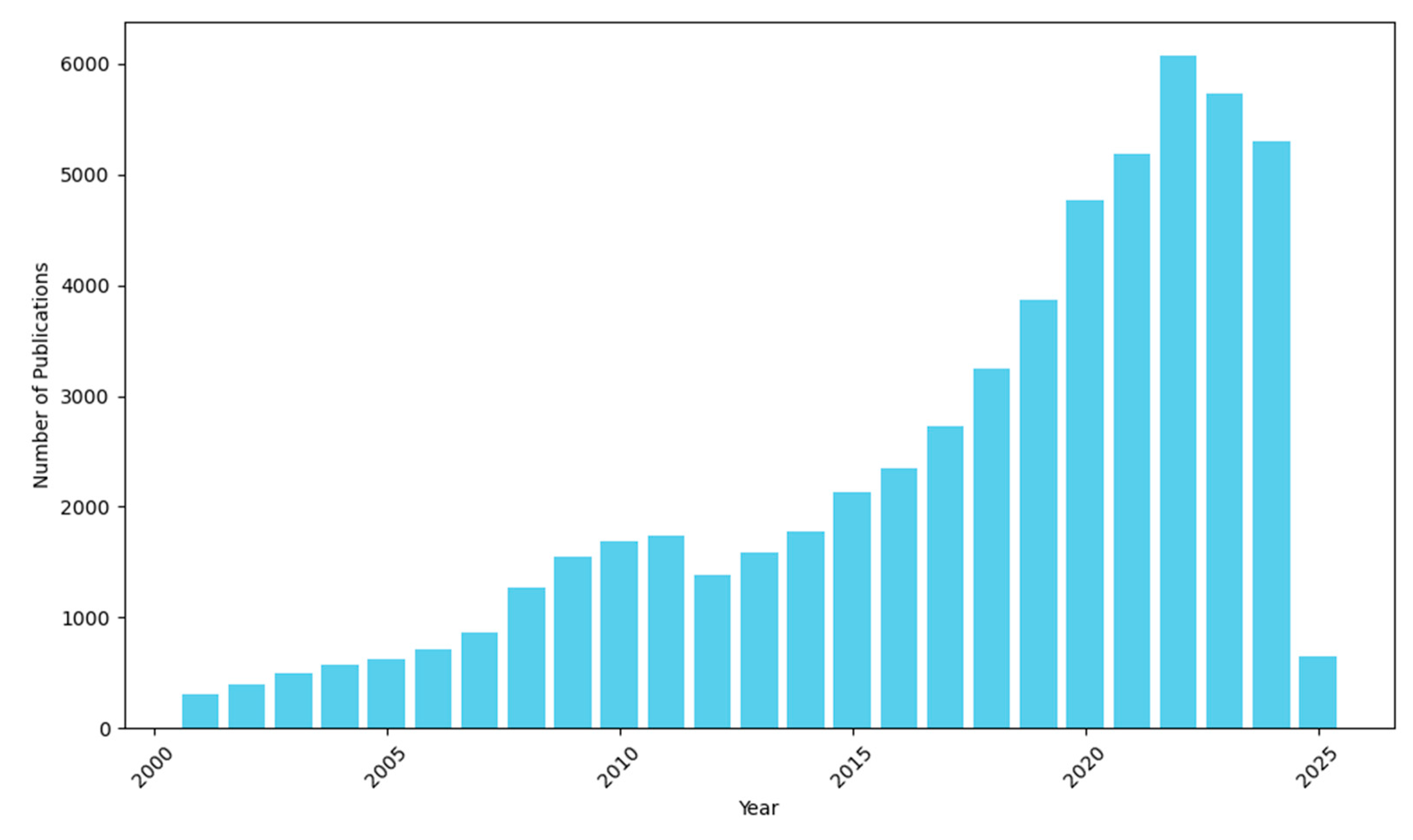
2.4. Bibliometric Analysis

Based on the bibliometric analysis conducted on the Web of Science using the keyword “City Information Modeling”, research in this field spans several key disciplines, highlighting its broad interdisciplinary applications [36]. Computer Science leads the field, demonstrating its central role in data processing, system integration, machine learning, and artificial intelligence technologies, all of which are crucial for the development of smart city frameworks and big data analytics. Engineering follows closely, focusing on CIM’s applications in urban infrastructure, energy management, and environmental monitoring, contributing to sustainable urban development. Environmental Sciences and Ecology also play a significant role, emphasizing CIM’s applications in ecological monitoring, environmental impact assessments, and green urban planning. In addition, Geography provides essential spatial data analysis capabilities for urban planning and land use management, while Mathematics offers the theoretical and computational foundation for modeling and optimizing CIM systems. Research in Public Environmental Occupational Health and Meteorology/Atmospheric Sciences highlights the integration of environmental health and weather data in CIM, contributing to urban resilience and sustainability. The presence of research in Science Technology Other Topics further showcases CIM’s impact across various technological domains. This distribution of research underscores CIM’s versatility as a comprehensive technological framework, applicable in diverse areas ranging from infrastructure and environmental protection to health and weather monitoring. The results are shown in Figure 1.
A bibliometric analysis of publications indexed in the Web of Science database using the keyword “City Information Modeling” reveals a continuous upward trend in research interest [36]. Although CIM research began in the 1990s, it remained relatively niche until the early 2000s, when the integration of a GIS and BIM laid the foundation for digital urban management. As information and communication technologies advanced, the research expanded beyond geographic data management to include urban infrastructure, resource optimization, and environmental monitoring. The 2010s marked a period of rapid growth, driven by the rise of smart cities, IoT, cloud computing, and big data analytics, leading to widespread applications in urban planning, transportation management, and environmental sustainability. Since 2015, the field has seen a surge in publications, particularly between 2018 and 2021, when the annual output consistently exceeded 5000 papers. Entering the 2020s, the integration of CIM with AI, 5G, and digital twins has further broadened its applications, making it a core technology for smart cities and sustainable urban development. The steady increase in the research output highlights CIM’s growing significance in academia and industry. The annual publication trends are illustrated in Figure 2.

3. Developments of CIM

CIM represents a holistic digital framework that seamlessly integrates urban planning, infrastructure management, and environmental monitoring, with the overarching goal of enhancing the intelligence and sustainability of urban management systems. Its evolution transcends mere technological innovation, encompassing critical dimensions such as data standardization, system interoperability, policy support, and multi-stakeholder collaboration. This multifaceted approach ensures more efficient, coordinated, and resilient urban governance.

3.1. Developments of CIM Across Countries

The global advancement of CIM is driven by a confluence of factors, including government policies, technological innovations, and the rapid urbanization observed across diverse regions [28]. As cutting-edge technologies such as the IoT, big data analytics, and AI continue to mature, the scope of CIM applications is expanding from infrastructure construction to more intricate domains of urban management and sustainable development. While the implementation strategies for CIM vary across countries, the shared objective remains consistent: harnessing digital transformation to optimize urban governance and operational efficiency.

3.1.1. Current Status of CIM Applications in Various Countries

With the rapid acceleration of urbanization, a growing number of countries are embracing CIM as a strategic tool to enhance the construction and management of smart cities. As an integrated and intelligent solution, CIM significantly enhances the urban management efficiency and bolsters the sustainable development capabilities across diverse domains, such as infrastructure management, environmental monitoring, and traffic optimization. The depth and scope of CIM applications vary across different countries, reflecting their distinct priorities and technological advancements in the pursuit of intelligent urban development. Globally, the application of CIM is increasingly permeating the diverse facets of urban management. Leading the charge are countries such as Singapore and the United States, which have demonstrated significant advancements in areas like smart city development, traffic management, and environmental monitoring. China has also achieved notable progress in digital city governance, with major metropolitan hubs like Shanghai, Beijing, and Shenzhen actively deploying CIM across a wide range of application scenarios [27]. In Europe, nations including Germany, the Netherlands, and France are prioritizing sustainable development, energy efficiency, and disaster management, leveraging CIM as a foundational tool to achieve these objectives. Furthermore, countries such as Japan, South Korea, Canada, and the United Arab Emirates are integrating CIM into their respective technological ecosystems to address the multifaceted urban challenges.
Table 2 below illustrates the contributions of various countries to the CIM framework across the key application areas, including smart cities, traffic management, environmental monitoring, energy management, real estate, and disaster management. Each country’s involvement is marked with a check or a cross, indicating the extent of their contribution or application in each domain. The classification is based on an extensive review of the academic literature, government policies, industrial reports, and case studies from authoritative sources. Countries with active implementation of CIM-related projects, significant policy support, or substantial research output in a given domain are marked with a check, while those with limited or no major contributions are marked with a cross. This classification helps to identify the trends in technological adoption and progress across different regions, providing valuable insights for future research, policy development, and the potential for collaboration in these critical sectors.

3.1.2. Exemplary City Information Modeling: Singapore

Singapore has emerged as a global benchmark for the application of CIM, spearheaded by its pioneering “Smart Nation” initiative, which has set a standard for smart city development worldwide. By comprehensively integrating the CIM framework into critical domains such as traffic management, energy optimization, environmental monitoring, and public services, Singapore has established a highly efficient and sustainable paradigm for urban management. A cornerstone of Singapore’s CIM implementation is the deployment of digital twin technology, which constructs a real-time, dynamic virtual replica of the city by synthesizing data from buildings, infrastructure, and transportation systems. Powered by AI and machine learning algorithms, this system processes vast amounts of data collected from IoT sensors to optimize urban operations, mitigate traffic congestion, enhance energy efficiency, and bolster the city’s resilience to environmental fluctuations.
Beyond its technological innovations, Singapore places a significant emphasis on fostering citizen engagement and promoting data transparency. Leveraging digital platforms and mobile applications, residents are empowered to access real-time urban data, submit feedback, and actively contribute to urban management processes. This open governance framework not only enhances the operational efficiency of public services but also strengthens government–citizen interaction, enabling collaborative and data-driven decision making. Furthermore, robust policy support and cross-departmental coordination have been pivotal to Singapore’s success in implementing CIM. The government has established comprehensive data standards, advanced system interoperability, and fostered public–private partnerships, ensuring the continuous evolution and scalability of the CIM framework. Singapore’s holistic approach offers a compelling model for the global advancement of CIM, demonstrating how the integration of digital city modeling, real-time data analytics, and participatory governance can collectively enhance the intelligence, sustainability, and resilience of modern urban ecosystems.

3.2. Problems Encountered in CIM Development

CIM serves as a critical enabler in urban planning, construction, and management; however, its development is confronted with several substantial challenges [50]. These challenges span multiple dimensions, including the legalization of data governance, the establishment of data standards, and the seamless integration of heterogeneous data sources. The subsequent discussion will explore these issues in detail and propose potential solutions to address them.

3.2.1. CIM Data Governance Legitimization Issues

Data governance constitutes a cornerstone of CIM, ensuring that urban data are systematically collected, processed, stored, and utilized in a manner that is legally compliant, secure, and reliable [16,43]. Among the critical aspects of CIM’s legal framework, data privacy and security have emerged as paramount concerns. The regulatory policies of different jurisdictions exert a profound influence on the legalization of CIM, significantly shaping its adoption and implementation trajectories [51]. However, notable challenges persist: the United States lacks a cohesive legal framework, leading to a fragmented and inconsistent approach to data governance; China has enacted the Data Security Law and the Personal Information Protection Law, yet disparities in local policy interpretations and enforcement mechanisms remain unresolved; in contrast, Singapore has established a robust governance model through its Smart Nation Plan, serving as a benchmark for effective implementation. To address these disparities, the advancement of CIM necessitates the development of enhanced data governance frameworks, strengthened cross-departmental collaboration, and the establishment of international standardization protocols. Such measures are essential to safeguarding data privacy and security, ensuring the legal compliance and operational efficacy of CIM applications.
Legalization remains a pivotal challenge in the development of CIM, particularly in addressing the issues related to data privacy, ethics, and ownership. Data privacy, a multifaceted yet critical concern, encompasses the collection, processing, and storage of sensitive information, including personal identity, behavioral patterns, and health data. To ensure robust privacy protection, nations must implement comprehensive data protection mechanisms and rigorously enforce the relevant legal frameworks. A prominent example is the European Union’s General Data Protection Regulation (GDPR), which establishes stringent privacy standards and regulatory requirements. Consequently, privacy protection must be embedded at the foundational stages of CIM implementation, incorporating techniques such as data anonymization, de-identification, and multi-layer encryption to mitigate the risks of data breaches. Beyond privacy, data ethics necessitates the adherence to the principles of fairness, transparency, and accountability throughout the entire data lifecycle—from collection and analysis to application. The handling of sensitive data requires maintaining ethical integrity to prevent bias, discrimination, or misuse, thereby safeguarding public trust. To address these concerns, it is imperative to develop international data ethics standards, promote the legislative enforcement of ethical principles, and establish national ethics review committees to oversee CIM projects. Moreover, data ownership represents a fundamental pillar of CIM governance, encompassing contributions from a wide array of stakeholders, including governments, enterprises, and individuals. Establishing clear and unambiguous ownership rights, coupled with well-defined usage regulations, is imperative for ensuring rational data management and maximizing its effective utilization. To address this challenge, it is essential to develop public–private data sharing platforms, supported by robust legal frameworks that explicitly delineate the ownership, access control, and usage rights. These measures will not only enhance the transparency and legal integrity of data-sharing agreements but also foster equitable benefits for all the stakeholders involved.

3.2.2. CIM Data Specification Issues

In the development of CIM, data standardization serves as a critical foundation for ensuring data consistency, reliability, and availability. As a novel and transformative production factor, data have rapidly permeated diverse domains, including production, distribution, circulation, consumption, and social service management, fundamentally reshaping production methodologies, lifestyle paradigms, and social governance frameworks. Nevertheless, in the practical implementation of CIM, the formulation and enforcement of data standards present significant challenges.
Data standardization encompasses the precise definition of the format, structure, and semantics of urban data, ensuring their accurate interpretation, processing, and exchange across heterogeneous systems. This foundational requirement is indispensable for achieving interoperability and facilitating the data sharing within CIM. Nevertheless, the implementation of standardized data practices encounters significant challenges due to the disparities in the policy frameworks, urban requirements, and technological ecosystems across nations, despite the ongoing efforts by international organizations and industry consortia to establish comprehensive data standards [52]. First, the quality of urban data remains inconsistent, primarily due to the variations in data collection methodologies and standards across different cities. These discrepancies often result in inaccurate or incomplete datasets, complicating their utilization and integration into CIM systems. Second, the absence of unified standards creates substantial barriers to effective data exchange and system interoperability. Many countries and regions have yet to adopt a common data standard for CIM, impeding the seamless communication between systems and hindering broader integration initiatives. To address these challenges, it is imperative to foster international collaboration aimed at harmonizing data structures and semantic specifications. This can be achieved by leveraging the established industry standards, such as those developed by the International Organization for Standardization (ISO) and the World Wide Web Consortium (W3C), and by establishing a global alliance for urban data standardization. Such an alliance would facilitate cross-border cooperation in the development and alignment of technical standards, ultimately advancing the evolution of CIM and promoting global-scale data sharing.

3.2.3. CIM Data Integration Issues

In the development of CIM, data integration plays a pivotal role in enabling the comprehensive analysis, visualization, and decision support for urban data. This process involves the systematic amalgamation of heterogeneous urban data from diverse sources, formats, and structures into a unified and cohesive model. By dismantling data silos, it enhances data interoperability and provides holistic, precise, and actionable insights for urban planning, management, and decision making [16].
Nevertheless, data integration continues to encounter significant challenges. First, the integration of heterogeneous data from multiple sources presents a formidable obstacle. Urban data are derived from diverse entities, including government agencies, businesses, and the public, with variations in data formats, standards, and storage methodologies, exacerbating the complexity of integration and complicating the maintenance of data consistency. Second, the mechanisms for cross-departmental data sharing remain underdeveloped, particularly in fostering collaboration between the public sector and private enterprises. The lack of a unified legal framework and standardized protocols restricts data circulation and interoperability. Furthermore, data security and privacy concerns constitute critical barriers to effective data integration. The existing data governance frameworks necessitate further refinement to ensure compliance and safeguard security throughout the data-sharing process [53].
To solve the above problems, it is recommended to take the following measures:
  • Develop unified data standards: leverage ISO 19157 [54] Geographic Information Data Quality Standards and OGC (Open Geospatial Consortium) standards to standardize data formats, semantics, and storage methods, thereby enhancing the cross-platform data interoperability.
  • Establish a cross-departmental data sharing mechanism: Create a City Data Sharing Committee to clarify data ownership and responsibilities. Implement blockchain and smart contract technologies to enforce data access control and traceability, strengthening data security.
  • Introduce intelligent data processing technologies: Utilize AI-driven data cleaning and fusion algorithms to improve the data quality and consistency. Optimize the data flow through ETL (Extract, Transform, Load) processes to increase the integration efficiency.
  • Build a CIM data integration platform: Adopt cloud computing architecture to support large-scale data storage and processing. Integrate knowledge graph technology to enhance the correlation and analytical capabilities of multi-source data, thereby constructing an efficient and intelligent data integration system.

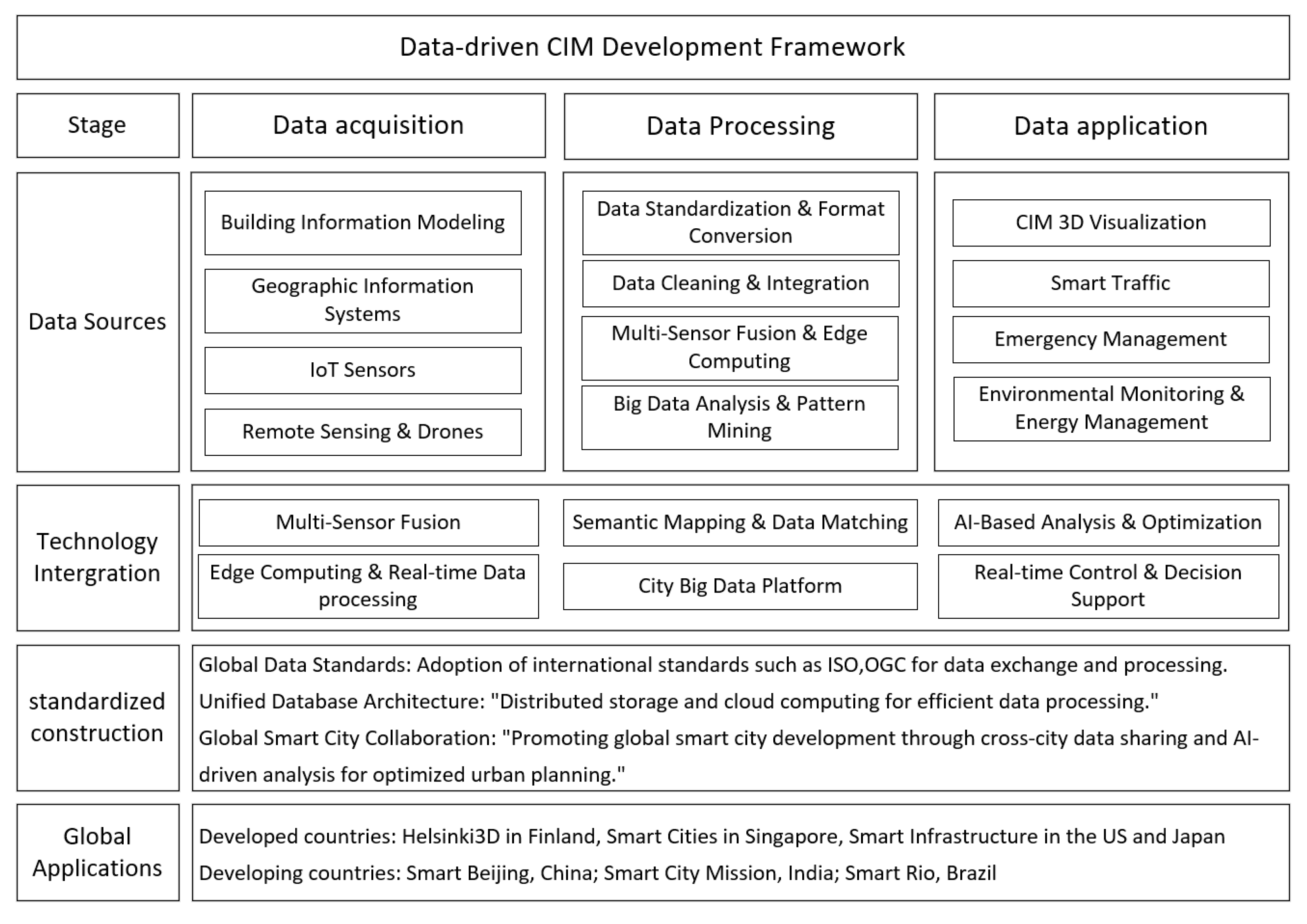
4. Data-Driven CIM Construction

With the rapid advancement of urban digitization, CIM is transitioning from static models to dynamic, data-driven intelligent systems. By harnessing multi-source data collection, intelligent analytics, and advanced visualization technologies, CIM enables the precise perception, predictive modeling, and optimization of urban operations, thereby enhancing the decision-making efficiency and resource allocation capabilities. In domains such as smart city management, transportation optimization, and energy distribution, data-driven CIM provides robust support for sustainable urban development.

4.1. Data-Driven CIM Framework

CIM is a city-level information management system that integrates advanced technologies such as BIM, GISs, and the IoT. Traditional CIM primarily relies on manual modeling and static data, whereas data-driven CIM achieves dynamic, real-time, and intelligent urban management through comprehensive processes of data collection, fusion, analysis, and application. CIM encompasses multiple critical aspects, including data acquisition, data processing, data modeling, visualization, and application. To enhance the efficiency and intelligence of CIM development, a data-driven CIM Development Framework (as illustrated in Figure 3) is designed, aiming to address the key challenges such as data governance, data standardization, and data integration in CIM implementation [31,36,40]. This framework comprises three core components: data collection, data processing, and data application. It incorporates the successful practices of BIM and GISs while addressing the unique requirements of CIM, ensuring data security, consistency, and efficient utilization, thereby advancing the construction of smart cities [52].
Data-driven CIM offers several core advantages: By integrating BIM, GISs, and big data analytics, CIM provides accurate, real-time urban operational data, serving as a scientific foundation for urban decision making. Leveraging IoT sensors and real-time data analytics, CIM can rapidly respond to the changes in urban operations and autonomously adjust the management strategies. Furthermore, data analytics facilitates the optimization of resource allocation by identifying the patterns in resource utilization, improving the efficiency of transportation, energy, and environmental management, and enhancing the overall urban operational efficiency. As a key enabler of smart cities, CIM supports applications in intelligent transportation, smart grids, urban safety management, and more, thereby boosting cities’ competitiveness and sustainability.

4.2. Data-Driven CIM Construction Process

The construction of CIM is a systematic process involving several key steps. First, the project objectives and requirements are defined, and specific application scenarios such as urban planning, smart transportation, and environmental monitoring are determined. Following this, data collection is carried out via multiple channels, including government departments, enterprises, sensor networks, and satellite imagery, ensuring data legitimacy and credibility [53,55]. After data collection, the data undergo processing and cleaning, including format conversion, error correction, deduplication, and completion, to ensure its quality. Next, data from various sources are integrated into a unified data model, and through matching and merging, a comprehensive urban information model is formed and stored in a secure system [36,56,57].
Data modeling and analysis are central to CIM construction, utilizing digital city models to analyze aspects such as traffic flow, environmental changes, and building structures. Subsequently, visualization tools are employed to transform complex data into easy-to-understand graphics and charts, aiding decision makers and the public in better understanding the information. Finally, CIM’s outputs are applied to urban management and decision making, such as optimizing the traffic flow and monitoring the air quality [57]. Ongoing maintenance and updates are essential to ensure the accuracy, timeliness, and stability of data and models. Through this series of steps, CIM provides strong support for urban planning and management, driving the intelligent development of cities [39,58,59].

4.2.1. Data Acquisition

In the construction process of CIM, data collection represents a critical initial phase. Leveraging the diverse technological approaches, a wide range of urban data types can be gathered, including spatial data, demographic data, transportation data, and environmental data. These datasets form the essential informational foundation for the development of CIM systems. During the data collection process, it is imperative to first clarify the specific data requirements of the city and align the objectives of CIM with these needs [16,55]. For instance, the specific demands of transportation, energy, and environmental sectors in smart cities should constitute the core focus of data collection to ensure that the data can effectively support the subsequent applications.
In the inventory stage of existing data, the initial step involves conducting a comprehensive evaluation of the city’s current data sources, encompassing multiple channels such as government agencies, enterprises, sensor networks, and satellite imagery. By assessing the data quality, completeness, and accessibility, gaps and deficiencies in the data can be identified, enabling the formulation of targeted data collection strategies. Additionally, it is essential to establish unified data standards and interoperability protocols to ensure the seamless integration and effective utilization of data from heterogeneous sources. Multiple technologies are frequently employed in the data collection process, and the integration of BIM and GIS concepts often serves as a pivotal approach to advancing the urban model development [28,60,61].

4.2.2. Data Processing

Data processing constitutes a pivotal phase in the construction of CIM, encompassing the cleaning, transformation, analysis, and mining of collected urban data to extract actionable insights that underpin the subsequent decision making and applications. The initial step in data processing is data cleaning, which involves tasks such as imputing missing values, detecting outliers, and standardizing formats to ensure that the data quality meets the prerequisites for advanced analysis [62]. Subsequently, the data undergo transformation, including procedures such as normalization and feature selection, to prepare them for modeling and analysis.
During this process, it is crucial to identify the patterns and trends in the data through advanced techniques such as spatial analysis, statistical analysis, machine learning, and data mining. GIS technology is employed for spatial analysis, while machine learning methods, including decision trees and clustering algorithms, are utilized to uncover hidden patterns and correlations. Furthermore, spatiotemporal analysis is applied to reveal the temporal dynamics and spatial distribution characteristics within the data, providing a robust scientific foundation for urban management and planning.
As data processing progresses, CIM systems, supported by efficient data infrastructure such as data lakes and data warehouses, are capable of managing the storage and processing of large-scale, heterogeneous datasets. This ensures that data flow seamlessly and reliably across various application processes, thereby enhancing the operational effectiveness of CIM in urban management.

4.2.3. Data Application

In the data application stage, CIM leverages the GIS and BIM technologies to construct a comprehensive digital city model, enabling the simulation and analysis of urban elements such as traffic flow dynamics, environmental changes, and building structural behaviors [63]. Advanced visualization tools are employed to transform complex datasets into intuitive graphs and charts, facilitating the enhanced comprehension and utilization of the information by decision makers and the public. The applications of CIM extend across domains such as intelligent transportation systems, energy management, and building optimization, significantly improving the urban services and quality of life through data-driven decision making [7,43]. For example, real-time traffic data can be utilized to optimize traffic signal control and navigation systems, while energy consumption data support the management of smart grids and the enhancement of energy efficiency. This holistic application of data ensures that urban management is both proactive and adaptive, addressing the immediate challenges while strategically planning for future developments.
CIM represents a comprehensive digital modeling and management framework for urban environments, integrating a diverse array of information technologies and advanced data analysis methodologies. Its applications span multiple domains, including intelligent transportation systems, smart energy networks, digital education platforms, elderly care solutions, healthcare systems, e-governance, and digital twin cities [7]. When applied to specific systems such as intelligent transportation, smart energy, and intelligent building management, CIM necessitates the acquisition of heterogeneous urban-related datasets. These datasets encompass geographic information, building data, traffic patterns, demographic statistics, and environmental metrics, sourced from government agencies, private enterprises, third-party data providers, and sensor networks. Following collection, the data undergo rigorous processes such as integration, cleaning, deduplication, standardization, and formatting to ensure their quality, consistency, and usability. The subsequent data analysis and processing involve the extraction of actionable insights and salient features through advanced techniques such as data mining, machine learning, and spatial analysis. These methodologies facilitate the identification of the patterns, trends, and correlations within the urban landscape, thereby generating foundational datasets for urban modeling. Once refined and structured, these data are operationalized in real-world urban management and planning scenarios [43]. CIM supports a broad spectrum of applications, including urban planning, traffic optimization, environmental monitoring, disaster mitigation, public safety, and municipal infrastructure management. By enabling the visualization, analysis, optimization, and decision making of urban information, CIM ultimately provides critical technical and strategic support for sustainable urban development and the enhancement of residents’ quality of life [39,43].
In summary, this systematic, data-driven approach to CIM construction fosters intelligent and sustainable urban development, while establishing a robust scientific foundation for effective urban management. By integrating and analyzing heterogeneous urban datasets, CIM significantly enhances the decision-making process, optimizes resource allocation, and elevates the quality of life for urban residents. This holistic methodology not only addresses the immediate challenges posed by rapid urbanization but also provides a scalable and resilient framework for the future development of smart cities.

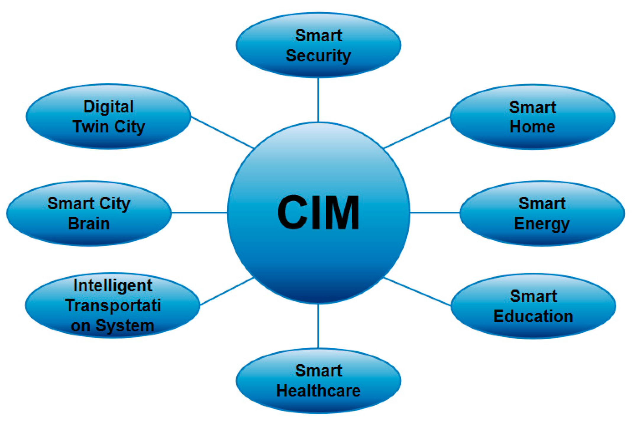
4.3. Example of Data-Driven CIM Construction

The integration of CIM into urban systems enables the seamless coordination and optimization of various city functions. CIM leverages big data, advanced analytics, and cutting-edge technologies such as artificial intelligence and the IoT to create a comprehensive framework for urban management. By aggregating the data from diverse sources, CIM enhances the decision making, operational efficiency, and overall quality of life in cities. Figure 4 illustrates several practical applications of CIM across different urban domains, including intelligent transportation, Smart Education, Smart City Brain, digital twin cities, and more. These applications collectively demonstrate the versatile and transformative impact of CIM on modern urban systems.

4.3.1. Intelligent Transportation System

Intelligent transportation systems (ITSs) utilize advanced technologies such as AI, big data analytics, and the IoT to monitor, manage, and optimize urban transportation networks effectively. The integration of CIM into an ITS brings significant improvements in three key areas: the seamless integration of traffic data, dynamic optimization of traffic signal control, and predictive analytics for traffic incident management.
CIM aggregates and integrates data from a variety of sources, including traffic surveillance cameras, vehicle sensors, GPS systems, and traffic signal infrastructures [64,65]. This heterogeneous data are processed in real time, offering traffic management authorities real-time insights into traffic flow, road conditions, and incidents. For example, in London, CIM integrates traffic cameras with GPS data from public transport, enabling the system to provide live updates on the traffic conditions and optimize the routing for buses during peak hours. Dynamic Optimization of Traffic Signals: CIM dynamically adjusts traffic signal timings based on real-time data to alleviate congestion. During high-traffic periods, such as rush hours, the system can extend the green light durations to ease bottlenecks. Conversely, during off-peak hours, the system shortens the green light phases to optimize the traffic flow [65]. In Berlin, CIM has been implemented to adjust the traffic signal timings dynamically, improving the flow during rush hours by 20% and reducing the wait times at intersections. Predictive analytics for traffic incident management: CIM plays a crucial role in traffic incident prediction and emergency management. By analyzing historical traffic data alongside real-time flow analytics, CIM identifies high-risk zones and predicts incidents before they happen. For example, in Tokyo, CIM leverages historical accident data and real-time traffic conditions to predict accident hotspots and issue early warnings. This allows traffic management teams to deploy emergency resources promptly and reduce the impact of accidents on the traffic flow.
Singapore’s intelligent transportation system: Singapore serves as a notable example of CIM in action. The city uses CIM to optimize the traffic signal timings, predict traffic bottlenecks, and improve the overall traffic conditions. By dynamically adjusting the traffic signals based on live data, Singapore has reduced the congestion during peak hours by 30%, significantly enhancing the urban mobility and efficiency.
In conclusion, CIM’s integration into ITSs enables real-time traffic monitoring, intelligent decision making, and optimized traffic flow. This integration not only improves the traffic management but also contributes to a more sustainable and efficient urban transportation system, benefiting both residents and urban planners.

4.3.2. Digital Twin City

Digital twin technology maps the lifecycle stages of physical entities into a virtual environment by leveraging physical models, sensor data, historical operational records, and other relevant information, providing a comprehensive representation of their operational status and behavioral patterns. In the context of smart cities, digital twin technology and CIM are intrinsically interconnected, and their integration significantly enhances the urban management and decision-making capabilities.
The primary role of CIM in a digital twin city is to serve as the foundational data integration framework, delivering accurate and real-time urban information to the digital twin model. This is accomplished by aggregating the data from diverse sensors, monitoring devices, and other data sources [66,67]. CIM integrates multi-dimensional datasets, including geographic information, building layouts, traffic flow dynamics, and energy consumption metrics, into a unified virtual platform. This integration enables the digital twin model to reflect the city’s dynamic changes in real time and simulate and predict various scenarios [4,7]. CIM offers robust data support for domains such as infrastructure management, environmental monitoring, and public safety, empowering the digital twin models to deliver real-time feedback on urban operations and simulate the evolving trends under different conditions [55]. For instance, by synthesizing traffic flow data, meteorological conditions, and energy consumption metrics, CIM can alert city managers to potential issues such as traffic congestion or energy inefficiency. One compelling example of CIM’s integration within a digital twin city is Songdo, South Korea. In this highly planned smart city, CIM gathers data from a variety of urban infrastructure sensors, ranging from traffic flow and waste management to energy consumption and environmental monitoring. The integration of these data into a digital twin model allows Songdo’s city planners to monitor urban operations in real time, providing insights that can prevent issues before they escalate. For example, real-time traffic data combined with the weather conditions enable the city’s traffic system to adjust signal timings dynamically, optimizing the traffic flow and reducing the congestion during peak hours. Similarly, CIM helps to identify the inefficiencies in energy use by comparing real-time data on building energy consumption with historical trends, prompting action to reduce energy waste.
In Dubai, the digital twin model, powered by CIM, is used to manage everything from infrastructure to resource allocation. The city integrates data from sensors across various domains—such as public transportation, building management, and environmental conditions—into a unified virtual model. This allows the city officials to simulate the effects of urban growth, infrastructure changes, or environmental fluctuations. For instance, when planning a new development, CIM can simulate its potential impact on local traffic flow, energy demand, and waste management systems, helping to create more sustainable urban environments. Furthermore, in the case of sudden urban challenges, such as traffic surges or energy shortages, Dubai’s digital twin system uses real-time data to predict potential issues and suggests optimal solutions, enhancing the city’s overall efficiency.
Tokyo, another city utilizing CIM for disaster management, shows how the integration of real-time data can play a pivotal role in the emergency response. By incorporating seismic sensors, building status data, and emergency service systems into a digital twin model, Tokyo can simulate the impact of natural disasters such as earthquakes. This enables the city to predict which areas will be most affected, optimize the resource distribution, and provide real-time decision support during emergency operations. For instance, in the event of a large-scale earthquake, CIM can help assess building damage, determine the evacuation routes, and ensure that the emergency services are dispatched efficiently to minimize disruption.
CIM also enhances the ability of cities to respond swiftly to environmental and public safety challenges. By integrating real-time data into digital twin models, urban areas can anticipate problems and simulate scenarios to develop more effective responses. For example, in Helsinki, Finland, CIM plays a vital role in managing city-wide systems, including transportation, waste management, and energy conservation. The digital twin model created from CIM data allows decision makers to simulate the effects of various changes, such as a new public transportation system or the expansion of green spaces, on traffic patterns, energy usage, and public services. This helps the city plan for the future while ensuring the sustainable management of resources.
In summary, CIM serves as the core data integration platform for digital twin cities, providing a precise and real-time representation of urban operations. Through its integration with digital twins, cities can more effectively simulate, monitor, and predict dynamic changes within urban environments [68,69]. This data-driven, intelligent management approach improves the urban decision-making accuracy, enhances the operational efficiency, and elevates the quality of public services. The examples of Songdo, Dubai, Tokyo, and Helsinki illustrate the vast potential of CIM in creating resilient, efficient, and adaptable urban systems.

4.3.3. Smart City Brain

The Smart City Brain represents the convergence of internet brain architecture and smart city development, creating a city-level, intelligent, and highly complex system. Built upon the Internet as its foundational infrastructure, it leverages vast urban data resources to conduct real-time, holistic analyses of citywide operations. By optimizing the allocation of public resources and continuously refining social governance, the Smart City Brain plays a key role in advancing sustainable urban development [70,71,72]. For example, in Hangzhou, China, the city’s Smart City Brain integrates diverse data sources such as traffic surveillance, environmental monitoring, and public security systems. Through advanced AI and data analytics, the city can optimize the traffic flow by dynamically adjusting signal timings, reducing congestion, and improving the air quality. The system also supports real-time crime analysis, helping law enforcement respond swiftly to incidents. By integrating these functionalities into one platform, Hangzhou enhances its urban management efficiency, while improving the daily lives of its residents.
To achieve intelligent urban operations and optimize urban management systems, the Smart City Brain harnesses cutting-edge information technologies, artificial intelligence, and data analytics. It processes data from sensors, surveillance cameras, social media, and other sources, performing comprehensive analyses across critical domains like transportation, energy management, environmental monitoring, and public security [29,73]. The system empowers urban managers with data-driven decision-making tools and improved management strategies. For instance, in Singapore, the Smart City Brain uses data analytics to monitor the energy consumption across the city, identifying inefficiencies and suggesting targeted improvements to reduce waste. It also integrates environmental data to forecast pollution levels, helping the authorities take preventive actions.
In summary, the Smart City Brain provides a framework for intelligent, coordinated urban management by enhancing the operational efficiency, optimizing resource allocation, and improving residents’ quality of life. The integration of diverse data sources allows cities to operate more sustainably and efficiently, offering a holistic approach to urban governance.

5. Discussion

5.1. Critical Analysis of Data-Driven CIM

Data-driven CIM is considered a crucial pillar for the future development of smart cities. Its core advantage lies in the integration of GIS, BIM, and IoT technologies, enabling the automated acquisition, processing, and analysis of urban data to support urban planning, infrastructure management, and real-time decision making. However, despite its theoretical advantages in regard to efficiency and intelligence, the practical implementation of data-driven CIM remains constrained by technical, managerial, and societal challenges [74].
(1)
Does data-driven CIM truly improve the urban management efficiency?
One of CIM’s primary objectives is to enhance urban management through intelligent automation. However, its actual effectiveness is often hampered by issues such as the data quality, computational capacity, and interdepartmental collaboration [75,76]. For instance, in Singapore’s Smart Nation Initiative, the government has attempted to integrate CIM with multi-dimensional data sources, including buildings, transportation, and energy systems, to achieve refined urban management [77]. However, in practice, the lack of standardized data formats and difficulties in cross-departmental data sharing have hindered the system’s data integration efficiency, reducing the effectiveness of real-time management. In the case of smart traffic management, data inconsistencies across different sensors—such as cameras and traffic flow detectors—have led to data fusion challenges, ultimately affecting the accuracy and timeliness of decision making.
Moreover, the implementation of CIM in small and medium-sized cities often faces high technological and financial costs. Particularly in developing countries, where the digital infrastructure remains underdeveloped, CIM systems may not necessarily be more efficient than the traditional urban management methods. Some smart city projects have reported unstable system performance due to the inadequate sensor quality and insufficient cloud computing resources, thereby undermining the anticipated efficiency gains. Thus, the value of CIM should be assessed based on the specific urban conditions rather than blindly promoted as a universal solution.
(2)
Is CIM truly capable of real-time data processing?
A key selling point of data-driven CIM is its ability to process urban data in real time and support intelligent decision making. However, in reality, its “real-time” capabilities are often constrained by computational resources, network latency, and data processing limitations [43,78]. For instance, during the Tokyo Olympics, the Japanese government leveraged CIM to optimize the urban traffic flows by integrating vehicle GPS data, public transportation information, and crowd monitoring systems. However, due to the massive volume of data and limited computational resources, delays in data processing affected the effectiveness of the real-time traffic optimization strategies.
To address this issue, edge computing has been introduced into CIM frameworks to reduce latency and enhance the real-time performance. In Barcelona’s smart city project, computational tasks were distributed across edge nodes, allowing data to be processed locally before being transmitted to the cloud, thereby alleviating the burden on the centralized computing resources. However, the widespread adoption of edge computing remains constrained by the high cost of infrastructure deployment and maintenance, making large-scale implementation challenging.
Furthermore, CIM’s decision-making mechanisms often rely on historical data and machine learning models, which may fail to adapt effectively to sudden disruptions or extreme environmental conditions. For example, during the 2023 Turkey earthquake, despite CIM being utilized for the disaster response, its reliance on pre-earthquake urban data limited its ability to accurately predict building collapse risks, impeding precise rescue operations. This highlights that CIM’s intelligence is highly dependent on the completeness and quality of the training data, posing challenges in unpredictable scenarios.
(3)
Challenges in data security, privacy, and ethics
The extensive reliance on large-scale data in CIM raises concerns about data security, privacy protection, and ethical considerations. CIM involves sensitive information, including citizens’ personal data, government planning details, and critical infrastructure records. Any data breach or misuse could have severe consequences. To address these issues, blockchain and federated learning have emerged as potential solutions for enhancing privacy protection in CIM [79].
Blockchain in CIM: Dubai’s smart city initiative has started incorporating blockchain technology to secure CIM data storage and sharing, enhancing the data traceability and security. The decentralized nature of blockchain reduces the risk of data breaches by eliminating the reliance on a single central server. However, blockchain’s computational overhead and slow transaction speeds remain major obstacles, making it less viable for real-time CIM applications.
Federated learning in CIM: In interdepartmental data-sharing scenarios, federated learning enables different government agencies to collaboratively train AI models without directly exchanging raw data, thereby improving the privacy protection. In some European smart city projects, federated learning has been explored for traffic prediction models, allowing multiple agencies to share model insights without compromising data privacy. However, high computational costs and prolonged training times continue to hinder large-scale deployment.
Additionally, ethical concerns surrounding CIM data governance are increasingly prominent. For example, in certain Chinese cities, CIM is integrated with facial recognition and public security monitoring, raising debates on the balance between urban safety and citizen privacy. Ensuring that CIM supports efficient urban management while safeguarding individual privacy remains a key challenge for future developments.
(4)
Scalability and adaptability of CIM
The applicability of CIM varies significantly across different cities due to the differences in data infrastructure, governance models, and technological capabilities. For instance, Singapore’s CIM is highly centralized, benefiting from strong governmental coordination, whereas in the United States, decentralized urban governance makes it difficult to establish a unified CIM framework. These structural differences affect the scalability and interoperability of CIM implementations.
To enhance CIM adaptability, reinforcement learning (RL) is being explored for intelligent optimization. For instance, in Boston’s smart traffic system, RL algorithms have been applied to optimize the traffic light control, dynamically adjusting the signal timing based on the real-time traffic conditions. However, RL-based approaches require large-scale training data and extensive simulation environments, and their decision-making processes often lack interpretability, posing challenges for real-world implementation.

5.2. Limitations of the Current Studies

Despite the significant theoretical and practical advancements, data-driven CIM still faces challenges in regard to the data quality, computational efficiency, security, and adaptability.
(1)
Data quality and multi-source data fusion
CIM relies on multi-source heterogeneous data, but inconsistencies, lack of standardization, and quality issues remain problematic. Graph Neural Networks (GNNs) enhance spatial-temporal data integration [80], while self-supervised learning and Large Language Models (LLMs) improve anomaly detection and standardization. However, these methods are computationally expensive and require extensive labeled data. Future research should focus on adaptive data fusion frameworks.
(2)
Computational efficiency and real-time processing
The real-time processing of large-scale urban data demands high computational resources. Edge computing and neuromorphic computing reduce latency, with autonomous traffic management systems leveraging edge AI for local processing. Spiking Neural Networks (SNNs) have shown promise for low-power environments, but hardware limitations persist. Optimizing efficient distributed computing architectures is crucial.
(3)
Data security and privacy protection
CIM involves sensitive data, making privacy protection essential. Federated learning (FL) enables AI model training across institutions without sharing raw data and is already tested in smart energy management [81,82]. Blockchain enhances secure data transactions, as seen in Dubai’s real estate sector. However, FL incurs high training costs, and blockchain has significant storage overheads. Future research should develop lightweight privacy-preserving mechanisms.
(4)
Adaptability and cross-city deployment
CIM adoption varies due to the differences in data structures, governance models, and infrastructure. Reinforcement Learning (RL) supports adaptive urban management, such as Boston’s traffic optimization. Digital twins are increasingly used for CIM simulation but face computational constraints. Future efforts should focus on lightweight RL models and hybrid digital twin architectures to enhance the cross-city scalability.

5.3. Research Challenges and Opportunities

Optimizing data governance is a key challenge for improving data-driven CIM systems. Data standardization is crucial in order to address multi-source data fusion issues, and technologies such as machine learning and big data analytics can significantly enhance the data quality and consistency. This can improve the accuracy and timeliness of decision support, especially in dynamic environments like smart traffic management, where data integration from various sensors is essential. Enhancing the real-time processing capabilities is another critical challenge. Distributed computing and edge computing are promising solutions to optimize the computational efficiency and reduce the response time, enabling CIM to handle large-scale urban data efficiently. These technologies are essential for scenarios requiring rapid decision making, such as emergency response and real-time urban management. Cross-departmental data sharing remains a significant hurdle. Addressing this requires both technical and policy solutions. Federated learning allows departments to collaborate on data analysis without sharing sensitive information, ensuring privacy while improving the decision quality. Meanwhile, stricter data-sharing standards and privacy regulations must be developed to ensure secure and compliant cross-departmental data exchanges. Lastly, social responsibility and ethical concerns are crucial for the future of CIM. Balancing data sharing with privacy protection and ensuring the fair and equitable use of public data will be central to advancing CIM systems. Technologies like blockchain and federated learning can enhance transparency, compliance, and data security, ensuring that CIM systems adhere to ethical standards while improving urban management.

6. Conclusions and Future Work

This survey systematically reviews the evolution of CIM, with a particular emphasis on its data-driven characteristics. CIM integrates GISs, BIM, and the IoT to achieve comprehensive urban data collection, management, analysis, and decision support [83]. However, the current research predominantly focuses on technical architecture, governance models, and application scenarios, leaving significant gaps in areas such as data governance, data quality assurance, and multi-source data fusion [67,84]. To address these limitations, this article systematically examines the data lifecycle of CIM, encompassing data collection, processing, analysis, and decision support, and proposes a data-driven CIM research framework aimed at enhancing its intelligence in smart city development.
The survey also explores the application of CIM in domains such as smart transportation, digital twin cities, environmental monitoring, and public safety, analyzing its integration trends with cutting-edge technologies like big data, AI, and cloud computing. Furthermore, this article highlights the critical challenges faced by CIM, including data security, privacy protection, and cross-departmental data sharing, and discusses its future development directions. These include the adaptation of urban data infrastructure, the development of intelligent decision-making systems, the creation of automated analysis models for multi-source heterogeneous data, and the deep integration of CIM with AI, blockchain, and other emerging technologies, offering forward-looking insights for future research and practice [85].
Despite its broad application potential across various urban management fields, CIM still faces several challenges. First, the diversity of urban data sources and the inconsistency in data formats necessitate robust solutions. Issues related to data quality, standardization, and consistency are critical and require further optimization of the data governance mechanisms. Second, achieving a balance between privacy protection and data sharing remains a significant challenge. Both technological and policy measures must be further explored to enable secure and efficient information sharing [86,87]. Additionally, the computational efficiency of CIM in processing large-scale datasets and performing real-time analysis needs improvement to meet the demands of city-level data processing, particularly in high-timeliness scenarios such as intelligent transportation management and emergency response.
Future research can focus on the following areas: First, enhancing CIM’s real-time processing capabilities for large-scale datasets by optimizing the computational architectures to support rapid analysis and intelligent decision making in complex, dynamic environments [88]. Second, improving the data standardization and integration processes to enhance the system compatibility and data quality, thereby facilitating the broader adoption of CIM across different cities and industries. The deep integration of CIM with AI will be a core research direction, leveraging AI technologies to strengthen the urban data governance capabilities and further explore the balance between data sharing, privacy protection, and social responsibility. Moreover, the effective integration of citizen-generated data (CGD) presents another promising avenue for research. Investigating how to utilize public participation data to improve the accuracy of urban management and the scientific basis of public decision making will be a critical issue in smart city development.
Data-driven CIM has profound social and economic implications for smart city construction. By enhancing the intelligence and precision of urban management, CIM is expected to improve operational efficiency, optimize resource allocation, and elevate residents’ quality of life [59]. Furthermore, CIM provides governments with scientific decision-making support, driving urban development towards smarter, greener, and more sustainable futures, and laying a solid foundation for the future of smart cities.

Author Contributions

Conceptualization, W.Y.; methodology, W.Y.; validation, X.Z., D.W. and J.D.; formal analysis, W.Y.; investigation, W.Y.; supervision, X.Z., D.W. and J.D.; project administration, X.Z., D.W. and J.D.; funding acquisition, J.D. All authors have read and agreed to the published version of the manuscript.

Funding

Supported by the Key R&D Program of Shandong Province, China (No. 2024ZLGX06), the Postdoctoral Fellowship Program of CPSF under Grant Number GZC20241614, and the Fundamental Research Funds for the Central Universities (No. 202264002).

Institutional Review Board Statement

Not applicable.

Informed Consent Statement

Not applicable.

Data Availability Statement

No new data were created or analyzed in this study. Data sharing is not applicable to this article.

Conflicts of Interest

The authors declare no conflict of interest.

References

  1. Padsala:, R.; Coors, V. Conceptualizing, Managing and Developing: A Web-Based 3D City Information Model for Urban Energy Demand Simulation. In Proceedings of the UDMV, Delft, The Netherlands, 23 November 2015. [Google Scholar]
  2. Dantas, H.S.; Sousa, J.M.M.S.; Melo, H.C. The Importance of City Information Modeling (CIM) for Cities’ Sustainability. IOP Conf. Ser. Earth Environ. Sci. 2019, 225, 012074. [Google Scholar] [CrossRef]
  3. Azevedo Guedes, A.L.; Carvalho Alvarenga, J.; Dos Santos Sgarbi Goulart, M.; Rodriguez y Rodriguez, M.V.; Pereira Soares, C.A. Smart Cities: The Main Drivers for Increasing the Intelligence of Cities. Sustainability 2018, 10, 3121. [Google Scholar] [CrossRef]
  4. Najafi, P.; Mohammadi, M.; van Wesemael, P.; Le Blanc, P.M. A User-Centred Virtual City Information Model for Inclusive Community Design: State-of-Art. Cities 2023, 134, 104203. [Google Scholar] [CrossRef]
  5. Wu, J.; Qiu, F.; Ma, L. Exploring the Potentials and Obstacles of City Information Modelling. In Routledge Handbook of Smart Built Environment; Routledge: Abingdon, UK, 2025; pp. 258–270. [Google Scholar]
  6. Soltanifard, H.; Farhadi, R.; Mansourian, H. City Information Modelling and Sustainable Development: The Role of CIM in Achieving Sustainable Urbanization. In City Information Modelling; Springer Nature Singapore: Singapore, 2024; pp. 17–32. [Google Scholar]
  7. Gil, J.; Almeida, J.; Duarte, J.P. The Backbone of a City Information Model (CIM). In Proceedings of the Respecting Fragile Places: Proceedings of the 29th Conference on Education in Computer Aided Architectural, Ljubljana, Slovenia, 21–24 September 2011; pp. 143–151. [Google Scholar]
  8. Stoter, J.; Ohori, K.A.; Ledoux, H. Geo-BIM data integration: Easier said than done? Geospat. World 2018, 9, 35–38. [Google Scholar]
  9. Cocchia, A. Smart and digital city: A systematic literature review. In Smart City: How to Create Public and Economic Value with High Technology in Urban Space; Springer: Cham, Switzerland, 2014; pp. 13–43. [Google Scholar]
  10. Dameri, R.P.; Cocchia, A. Smart city and digital city: Twenty years of terminology evolution. In Proceedings of the X Conference of the Italian Chapter of AIS, ITAIS, Milan, Italy, 14 December 2013; Volume 1. [Google Scholar]
  11. Shi, Y.; Han, Q.; Shen, W.; Zhang, H. Potential applications of 5G communication technologies in collaborative intelligent manufacturing. IET Collab. Intell. Manuf. 2019, 1, 109–116. [Google Scholar] [CrossRef]
  12. Khalil, I.G.; Mohamed, A.; Smail, Z. Building Information Modeling for rural road design: A case study. In Proceedings of the 2021 16th International Conference on Electronics, Computer and Computation (ICECCO), Kaskelen, Kazakhstan, 25–26 November 2021; pp. 1–7. [Google Scholar]
  13. Zingariello, I. From BIM to CIM: A new instrument for urban planners and a new bottom-up planning process. In Proceedings of the International Conference on Innovation in Urban and Regional Planning, Catania, Italy, 8–10 September 2021; pp. 189–193. [Google Scholar]
  14. Yu, Q.; Wang, C.; Cetiner, B.; Yu, S.X.; Mckenna, F.; Taciroglu, E.; Law, K.H. Building Information Modeling and Classification by Visual Learning at a City Scale. arXiv 2019, arXiv:1910.06391. [Google Scholar]
  15. Xue, F.; Wu, L.; Lu, W. Semantic Enrichment of Building and City Information Models: A Ten-Year Review. Adv. Eng. Inform. 2021, 47, 101245. [Google Scholar] [CrossRef]
  16. Thompson, E.M.; Greenhalgh, P.; Muldoon-Smith, K.; Charlton, J.; Dolník, M. Planners in the Future City: Using City Information Modelling to Support Planners as Market Actors. Urban Plann. 2016, 1, 79–94. [Google Scholar] [CrossRef]
  17. Dall’O’, G.; Zichi, A.; Torri, M. Green BIM and CIM: Sustainable Planning Using Building Information Modelling. In Green Planning for Cities and Communities; Dall’O’, G., Ed.; Springer International Publishing: Berlin/Heidelberg, Germany, 2020; pp. 383–409. [Google Scholar] [CrossRef]
  18. Pan, Y.; Zhang, L. Integrating BIM and AI for smart construction management: Current status and future directions. Arch. Comput. Methods Eng. 2023, 30, 1081–1110. [Google Scholar] [CrossRef]
  19. Waqar, A.; Othman, I.; Saad, N.; Azab, M.; Khan, A.M. BIM in green building: Enhancing sustainability in the small construction project. Clean. Environ. Syst. 2023, 11, 100149. [Google Scholar] [CrossRef]
  20. Nguyen, T.D.; Adhikari, S. The role of BIM in integrating digital twin in building construction: A literature review. Sustainability 2023, 15, 10462. [Google Scholar] [CrossRef]
  21. Heidari, A.; Peyvastehgar, Y.; Amanzadegan, M. A systematic review of the BIM in construction: From smart building management to interoperability of BIM & AI. Archit. Sci. Rev. 2024, 67, 237–254. [Google Scholar]
  22. Li, X.; Lv, Z.; Hu, J.; Zhang, B.; Shi, L.; Feng, S. Xearth: A 3D GIS Platform for Managing Massive City Information. In Proceedings of the 2015 IEEE International Conference on Computational Intelligence and Virtual Environments for Measurement Systems and Applications (CIVEMSA), Shenzhen, China, 12–14 June 2015. [Google Scholar]
  23. Schiefelbein, J.; Javadi, A.; Lauster, M.; Remmen, P.; Streblow, R.; Müller, D. Development of a City Information Model to Support Data Management and Analysis of Building Energy Systems within Complex City Districts. In Proceedings of the International Conference CISBAT 2015 Future Buildings and Districts Sustainability from Nano to Urban Scale; LESO-PB, EPFL, Lausanne, Switzerland, 9–11 September 2015. [Google Scholar]
  24. Mohammed, S.; Alkhereibi, A.H.; Abulibdeh, A.; Jawarneh, R.N.; Balakrishnan, P. GIS-based spatiotemporal analysis for road traffic crashes; in support of sustainable transportation planning. Transp. Res. Interdiscip. Perspect. 2023, 20, 100836. [Google Scholar] [CrossRef]
  25. Alam, M.S.; Tabassum, N.J. Spatial pattern identification and crash severity analysis of road traffic crash hot spots in Ohio. Heliyon 2023, 9, e16303. [Google Scholar] [CrossRef] [PubMed]
  26. Ilniyazovich, S.F. Using GIS software and the importance of digital history in the study of history. Int. J. Hist. Political Sci. 2023, 3, 31–33. [Google Scholar] [CrossRef]
  27. Gil, J.; Beirao, J.; Montenegro, N.; Duarte, J. Assessing Computational Tools for Urban Design: Towards a “City Information Model”. In Proceedings of the 28th Conference on Future Cities, Zurich, Switzerland, 15–18 September 2010. [Google Scholar]
  28. Souza, L.; Bueno, C. City Information Modelling as a Support Decision Tool for Planning and Management of Cities: A Systematic Literature Review and Bibliometric Analysis. Build. Environ. 2022, 207, 108403. [Google Scholar] [CrossRef]
  29. Wang, B.L.; Tian, Y. Research on Key Technologies of City Information Modeling. IOP Conf. Ser. Earth Environ. Sci. 2021, 693, 012129. [Google Scholar] [CrossRef]
  30. Fang, J.; Xie, X.; Xu, J. Development and key technologies for architectural design and technical solutions of CIM platform: A review. IOP Conf. Ser. Earth Environ. Sci. 2024, 1337, 012036. [Google Scholar] [CrossRef]
  31. Bi, Z.; Jin, Y.; Maropoulos, P.; Zhang, W.J.; Wang, L. Internet of things (IoT) and big data analytics (BDA) for digital manufacturing (DM). Int. J. Prod. Res. 2023, 61, 4004–4021. [Google Scholar] [CrossRef]
  32. Ashwini, B.P.; Savithramma, R.M. Artificial Intelligence in Smart city applications: An overview. In Proceedings of the 2022 6th International Conference on Intelligent Computing and Control Systems (ICICCS), Madurai, India, 15–17 May 2022; pp. 986–993. [Google Scholar]
  33. Herath, H.M.K.K.M.B.; Mittal, M. Adoption of artificial intelligence in smart cities: A comprehensive review. Int. J. Inf. Manag. Data Insights 2022, 2, 100076. [Google Scholar] [CrossRef]
  34. Luckey, D.; Fritz, H.; Legatiuk, D.; Dragos, K.; Smarsly, K. Artificial intelligence techniques for smart city applications. In Proceedings of the 18th International Conference on Computing in Civil and Building Engineering: ICCCBE 2020, São Paulo, Brazil, 18–20 August 2020; Springer International Publishing: Berlin/Heidelberg, Germany, 2021; pp. 3–15. [Google Scholar]
  35. Tekouabou, S.C.; Gherghina, Ş.C.; Kameni, E.D.; Filali, Y.; Idrissi Gartoumi, K. AI-Based on Machine Learning Methods for Urban Real Estate Prediction: A Systematic Survey. Arch. Comput. Methods Eng. 2024, 31, 1079–1095. [Google Scholar] [CrossRef]
  36. Xu, Z.; Qi, M.; Wu, Y.; Hao, X.; Yang, Y. City Information Modeling: State of the Art. Appl. Sci. 2021, 11, 9333. [Google Scholar] [CrossRef]
  37. Wu, Z.; Gan, W. Urban Intelligent Planning Technology Practice in Transitional Period. Urban. Archit. 2018, 3, 28–31. (In Chinese) [Google Scholar]
  38. Xu, X.; Ding, L.; Luo, H.; Ma, L. From Building Information Modeling to City Information Modeling. J. Inf. Technol. Constr. 2014, 19, 292–307. [Google Scholar]
  39. Stojanovski, T. City Information Modeling (CIM) and Urbanism: Blocks, Connections, Territories, People and Situations. In Proceedings of the Symposium on Simulation for Architecture and Urban Design, Hamilton, ON, Canada, 23–26 May 2013; pp. 86–93. [Google Scholar]
  40. Stojanovski, T. City Information Modelling (CIM) and Urban Design Morphological Structure, Design Elements and Programming Classes in CIM. In Proceedings of the ECAADE 2018: Computing a Better Tomorrow, Łódź, Poland, 19–21 September 2018; pp. 507–516. [Google Scholar]
  41. Montenegro, N.; Duarte, J.P. Computational Ontology of Urban Design. In Towards a City Information Model. In Proceedings of the eCAADe 27 Computation: The new realm of Architectural Design, Istanbul, Turkey, 19 September 2009; pp. 253–260. [Google Scholar]
  42. Lee, S.-H.; Park, J.; Park, S.I. City Information Model-Based Damage Estimation in Inundation Condition. In Proceedings of the 2016 International Conference on Computing in Civil and Building Engineering (ICCCBE 2016), Osaka, Japan, 6–9 July 2016. [Google Scholar]
  43. Wang, Z.; Jiang, H.; Zhang, W.; Liu, L. The Problem Analysis and Solution Suggestion in the Process of City Information Model Construction. In Proceedings of the 2020 4th International Conference on Smart Grid and Smart Cities (ICSGSC), Osaka, Japan, 18–21 August 2020. [Google Scholar]
  44. ISO 19650-1:2018; Organization and Digitization of Information about Buildings and Civil Engineering Works, Including Building Information Modelling (BIM)—Information Management Using Building Information Modelling—Part 1: Concepts and Principles. ISO: Geneva, Switzerland, 2018.
  45. ISO/IEC 30162:2022; Internet of Things (IoT)—Compatibility Requirements and Model for Devices within Industrial IoT Systems. ISO/IEC: Geneva, Switzerland, 2022.
  46. ISO/IEC 30173:2023; Digital Twin—Concepts and Terminology. ISO/IEC: Geneva, Switzerland, 2023.
  47. ISO 37120:2018; Sustainable Cities and Communities—Indicators for City Services and Quality of Life. ISO: Geneva, Switzerland, 2018.
  48. ISO 37106:2021Sustainable cities and Communities—Guidance on Establishing Smart City Operating Models for Sustainable Communities; ISO: Geneva, Switzerland, 2021.
  49. ISO/IEC 30146:2019; Information Technology—Smart City ICT Indicators. ISO/IEC: Geneva, Switzerland, 2019.
  50. Almeida, F.A.d.S.; Andrade, M.L.V.X. Considerações Sobre o Conceito de City Information Modeling. InSitu São Paulo 2018, 4, 21–38. [Google Scholar]
  51. Hamilton, A.; Wang, H.; Tanyer, A.M.; Arayici, Y.; Zhang, X.; Song, Y. Urban Information Model for City Planning. J. Inf. Technol. Constr. 2005, 10, 55–67. [Google Scholar]
  52. Pelden, S.; Banihashemi, S.; Mohandes, S.R.; Arashpour, M.; Kalantari, M. Enhancing Infrastructure Planning and Design Through BIM-GIS Integration. Struct. Infrastruct. Eng. 2025, 1, 1–20. [Google Scholar] [CrossRef]
  53. Akindele, O.; Ajayi, S.; Oyegoke, A.S.; Alaka, H.A.; Omotayo, T. Application of Geographic Information System (GIS) in Construction: A Systematic Review. Smart Sustain. Built Environ. 2025, 14, 210–236. [Google Scholar] [CrossRef]
  54. ISO 19157-1:2023; Geographic Information—Data Quality. Part 1: General Requirements. ISO/IEC: Geneva, Switzerland, 2023.
  55. Gil, J. City Information Modelling: A Conceptual Framework for Research and Practice in Digital Urban Planning. Built Environ. 2020, 46, 501–527. [Google Scholar] [CrossRef]
  56. Reitz, T.; Schubiger-Banz, S. The ESRI 3D City Information Model. IOP Conf. Ser. Earth Environ. Sci. 2014, 18, 012172. [Google Scholar] [CrossRef]
  57. Jiang, Y.; Sun, J. Does Smart City Construction Promote Urban Green Development? Evidence from a Double Machine Learning Model. J. Environ. Manag. 2025, 373, 123701. [Google Scholar] [CrossRef] [PubMed]
  58. Jitta, A.S.; Manda, V.K.; Tarnanidis, T. Geospatial Technologies for Smart Cities. In Recent Trends in Geospatial AI; IGI Global Scientific Publishing: Hershey, PA, USA, 2025; pp. 103–136. [Google Scholar]
  59. González-Arellano, S. Cities as Anticipatory Systems. In Cities as Anticipatory Systems; Springer Nature Switzerland: Cham, Switzerland, 2025; pp. 13–30. [Google Scholar]
  60. Melo, H.C.; Tomé, S.M.G.; Silva, M.H.; Gonzales, M.M.; Gomes, D.B.O. Implementation of City Information Modeling (CIM) Concepts in the Process of Management of the Sewage System in Piumhi, Brazil. IOP Conf. Ser. Earth Environ. Sci. 2019, 225, 1. [Google Scholar] [CrossRef]
  61. Pereira, A.P.; Buzzo, M.; Zimermann, I.; Neto, F.H.; Malgarezi, H. A Descriptive 3D City Information Model Built from Infrastructure BIM: Capacity Building as a Strategy for Implementation. Int. J. E-Plan. Res. 2021, 10, 138–151. [Google Scholar] [CrossRef]
  62. Monteiro, C.S.; Costa, C.; Pina, A.; Santos, M.Y.; Ferrão, P. An Urban Building Database (UBD) Supporting a Smart City Information System. Energy Build. 2018, 158, 244–260. [Google Scholar] [CrossRef]
  63. Veerendra, G.T.N.; Dey, S.; Mantle, E.J.; Manoj, A.P.; Padavala, S.S.A.B. Building Information Modeling—Simulation and Analysis of a University Edifice and Its Environs—A Sustainable Design Approach. Green Technol. Sustain. 2025, 3, 100150. [Google Scholar] [CrossRef]
  64. Asmari, A.F.; Almutairi, A.; Alanazi, F.; Alqubaysi, T.; Armghan, A. Conjecture Interaction Optimization Model for Intelligent Transportation Systems in Smart Cities Using Reciprocated Multi-Instance Learning for Road Traffic Management. IEEE Access 2025, 13, 34539–34562. [Google Scholar] [CrossRef]
  65. Elassy, M.; Al-Hattab, M.; Takruri, M.; Badawi, S. Intelligent Transportation Systems for Sustainable Smart Cities. Transp. Eng. 2024, 16, 100252. [Google Scholar] [CrossRef]
  66. Faliagka, E.; Christopoulou, E.; Ringas, D.; Politi, T.; Kostis, N.; Leonardos, D.; Tranoris, C.; Antonopoulos, C.P.; Denazis, S.; Voros, N. Trends in digital twin framework architectures for smart cities: A case study in smart mobility. Sensors 2024, 24, 1665. [Google Scholar] [CrossRef]
  67. Batty, M. Digital twins in city planning. Nat. Comput. Sci. 2024, 4, 192–199. [Google Scholar] [CrossRef]
  68. Mazzetto, S. A Review of Urban Digital Twins Integration, Challenges, and Future Directions in Smart City Development. Sustainability 2024, 16, 8337. [Google Scholar] [CrossRef]
  69. Yeh, A.G. From urban modelling, GIS, the digital, intelligent, and the smart city to the digital twin city with AI. Environ. Plan. B Urban Anal. City Sci. 2024, 51, 1085–1088. [Google Scholar] [CrossRef]
  70. Bibri, S.E.; Huang, J.; Krogstie, J. Artificial intelligence of things for synergizing smarter eco-city brain, metabolism, and platform: Pioneering data-driven environmental governance. Sustain. Cities Soc. 2024, 108, 105516. [Google Scholar] [CrossRef]
  71. Bai, O.; Shi, Y.; Wu, F. Pioneering the Post-Smart Cities Paradigm in Urban Innovation Ecosystems Governance: A Case Study of Hangzhou City-Brain Initiative. Urban Policy Res. 2025, 1–25. [Google Scholar] [CrossRef]
  72. Xu, Y.; Cugurullo, F.; Zhang, H.; Gaio, A.; Zhang, W. The emergence of artificial intelligence in anticipatory urban governance: Multi-scalar evidence of China’s transition to city brains. J. Urban Technol. 2024, 1–25. [Google Scholar] [CrossRef]
  73. Stojanovski, T.; Partanen, J.; Samuels, I.; Sanders, P.; Peters, C. City information modelling (CIM) and digitizing urban design practices. Built Environ. 2020, 46, 637–646. [Google Scholar] [CrossRef]
  74. Shi, J.; Pan, Z.; Jiang, L.; Zhai, X. An ontology-based methodology to establish city information model of digital twin city by merging, B. I.M, GIS and IoT. Adv. Eng. Inform. 2023, 57, 102114. [Google Scholar] [CrossRef]
  75. Halim, N.Z.A.; Karim, H.; Bernad, S.C.; Lim, C.K.; Mohamed, A. Enhancing SmartKADASTER 3D city model with stratified information in supporting Smart City enablement. In Proceedings of the Sustainable Smart Cities and Territories International Conference, Doha, Qatar, 27–29 April 2021; Springer International Publishing: Cham, Switzerland; pp. 175–186. [Google Scholar]
  76. Ji, J.; Wang, K.; Wang, Z.H.; Zhang, N. Research on the connotation of city information modeling (CIM) enabling smart city construction. Urban Dev. Stud. 2021, 28, 65–69. [Google Scholar]
  77. Stouffs, R.; Tauscher, H.; Biljecki, F. Achieving complete and near-lossless conversion from IFC to CityGML. ISPRS Int. J. Geo-Inf. 2018, 7, 355. [Google Scholar] [CrossRef]
  78. Wang, T.; Bhuiyan, M.Z.A.; Wang, G.; Rahman, M.A.; Wu, J.; Cao, J. Big data reduction for a smart city’s critical infrastructural health monitoring. IEEE Commun. Mag. 2018, 56, 128–133. [Google Scholar] [CrossRef]
  79. Wang, P.; Ali, A.; Kelly, W. Data security and threat modeling for smart city infrastructure. In Proceedings of the 2015 International Conference on Cyber Security of Smart Cities, Industrial Control System and Communications (SSIC), Shanghai, China, 5–7 August 2015; pp. 1–6. [Google Scholar]
  80. Zhu, W.; He, W.; Li, Q. Hybrid AI and Big Data Solutions for Dynamic Urban Planning and Smart City Optimization. IEEE Access 2024, 12, 189994–190006. [Google Scholar] [CrossRef]
  81. Yin, X.; Qiu, H.; Wu, X.; Zhang, X. An Efficient Attribute-Based Participant Selecting Scheme with Blockchain for Federated Learning in Smart Cities. Computers 2024, 13, 118. [Google Scholar] [CrossRef]
  82. Wang, W.; Li, P.; Li, S.; Zhang, J.; Zhou, Z.; Wu, D.O.; Kim, D.K.; Zhang, G.; Gong, P. Optimizing Proximity Strategy for Federated Learning Node Selection in the Space-Air-Ground Information Network for Smart Cities. IEEE Internet Things J. 2024, 12, 6418–6430. [Google Scholar] [CrossRef]
  83. Chen, K.; Lu, W.; Xue, F.; Tang, P.; Li, L.H. Automatic building information model reconstruction in high-density urban areas: Augmenting multi-source data with architectural knowledge. Autom. Constr. 2018, 93, 22–34. [Google Scholar] [CrossRef]
  84. Fadhel, M.A.; Duhaim, A.M.; Saihood, A.; Sewify, A.; Al-Hamadani, M.N.; Albahri, A.S.; Alzubaidi, L.; Gupta, A.; Mirjalili, S.; Gu, Y. Comprehensive systematic review of information fusion methods in smart cities and urban environments. Inf. Fusion 2024, 107, 102317. [Google Scholar] [CrossRef]
  85. Okonta, D.E.; Vukovic, V. Smart cities software applications for sustainability and resilience. Heliyon 2024, 10, e32654. [Google Scholar] [CrossRef]
  86. Zhou, Y.; Liu, J. Advances in emerging digital technologies for energy efficiency and energy integration in smart cities. Energy Build. 2024, 315, 114289. [Google Scholar] [CrossRef]
  87. Gkontzis, A.F.; Kotsiantis, S.; Feretzakis, G.; Verykios, V.S. Enhancing urban resilience: Smart city data analyses, forecasts, and digital twin techniques at the neighborhood level. Future Internet 2024, 16, 47. [Google Scholar] [CrossRef]
  88. Costa, D.G.; Bittencourt, J.C.N.; Oliveira, F.; Peixoto, J.P.J.; Jesus, T.C. Achieving sustainable smart cities through geospatial data-driven approaches. Sustainability 2024, 16, 640. [Google Scholar] [CrossRef]
Figure 1. Major research disciplines in City Information Modeling (CIM).
Applsci 15 04696 g001
Figure 2. Annual publication trends of City Information Modeling (CIM) research.
Applsci 15 04696 g002
Figure 3. Data-driven CIM development framework.
Applsci 15 04696 g003
Figure 4. Example of data-driven CIM construction.
Applsci 15 04696 g004
Table 1. Key milestones in the development of CIM standards.
TimeStandard NameRelevant FieldStandard Overview
2018ISO 37120Urban SustainabilityFocuses on urban sustainability and the quality of life by providing standardized indicators and a data management framework.
2018ISO 19650BIMDefines the information management for buildings and civil engineering works through the organization and digitization of data, including BIM.
2019ISO/IEC 30146:2019 [49]Information TechnologyDefines a framework of evaluation indicators for ICT adoption in smart cities, detailing each indicator’s name, description, classification, and measurement method.
2021ISO 37106Smart Cities and Sustainable cities Sustainable cities and communities—guidance on establishing smart city operating models for sustainable communities
2022ISO/IEC 30162:2022IoTIoT—compatibility requirements and a model for devices within industrial IoT systems
2023ISO/IEC 30173:2023Digital TwinDigital twin—concepts and terminology
Table 2. Country contributions to CIM applications across key domains.
Country/RegionSmart CitiesTraffic
Management
Environmental MonitoringEnergy
Management
Real EstateDisaster
Management
Singapore×××
United States××
China××
Germany××
Netherlands××
France××
United Kingdom×××
Japan×××
South Korea×××
Canada×××
Australia×××
UAE××××
India××××
Disclaimer/Publisher’s Note: The statements, opinions and data contained in all publications are solely those of the individual author(s) and contributor(s) and not of MDPI and/or the editor(s). MDPI and/or the editor(s) disclaim responsibility for any injury to people or property resulting from any ideas, methods, instructions or products referred to in the content.

