
Satellite to Ground Station, Attenuation Prediction for 2.4–72 GHz Using LTSM, an Artificial Recurrent Neural Network Technology


Abstract
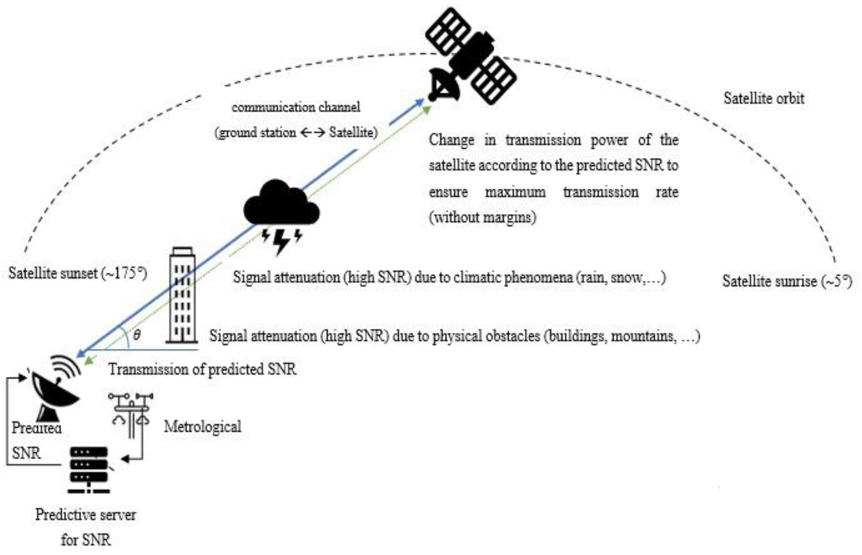
:1. Introduction
2. Related Work
3. Predicting the Signal Attenuation Level at Free Space (Section A)
3.1. Collecting the SNR and Weather Conditions
3.2. Collecting the Attenuation Levels
3.3. Application of the Prediction Model
3.3.1. Building the Database for the Learner
3.3.2. Developing the Predictive Models
- Accept the training and testing dataset—Table 1 is an example of the training and testing dataset required to input the predicting system.
- Execute the prediction deep-learning algorithm—The input and output of the prediction procedure:
3.3.3. Training the Learning System That Predicts the Channel Attenuation
3.3.4. Developing a Model That Ensures the Maximum Transmission Rate
3.4. LSTM Neural Network Prediction Experiment across Seasons
3.5. Prediction Experiment for 2.4–72 GHz
4. The Prediction Model When Signal Approaches the Ground Station (Section B)
4.1. Measuring Building Shadowing Loss
4.2. Setting Up the Prediction Model Testbed
4.3. Constructing the Database for the Learner
4.4. Developing the Predictive Model
- (1)
- Accept the training and experiment dataset.
- (2)
- Execute the prediction deep-learning algorithm.
4.5. Training the Learning System
4.6. Aligning the Satellite Signal Strength
4.7. The Setup of the LSTM Experiment
5. Conclusions and Further Work
Author Contributions
Funding
Conflicts of Interest
References
- Domb, M.; Leshem, G. Rain Attenuation Prediction for 2.4–72 GHz using LTSM, an artificial recurrent neural network technology. In Proceedings of the 2021 International Conference on Electrical, Communication, and Computer Engineering (ICECCE), Kuala Lumpur, Malaysia, 12–13 June 2021; pp. 1–6. [Google Scholar] [CrossRef]
- Samad, M.A.; Choi, D.-Y. Learning-Assisted Rain Attenuation Prediction Models. Appl. Sci. 2020, 10, 6017. [Google Scholar] [CrossRef]
- Kalaivaanan, M.; Sali, A.; Raja Abdullah, R.S.A.; Yaakob, S.; Singh, M.J.; Al-Saegh, A.M. Evaluation of ka-band rain attenuation for satellite communication in tropical regions through a measurement of multiple antenna sizes. IEEE Access 2020, 8, 18007–18018. [Google Scholar] [CrossRef]
- Dahman, I.; Arbogast, P.; Jeannin, N.; Benammar, B. Rain attenuation prediction model for satellite communications based on the Météo-France ensemble prediction system PEARP. Nat. Hazards Earth Syst. Sci. 2018, 18, 3327–3341. [Google Scholar] [CrossRef] [Green Version]
- Golovachev, Y.; Pinhasi, G.A.; Pinhasi, Y. Atmospheric Effects on OFDM Wireless Links Operating in the Millimeter Wave Regime. Electronics 2020, 9, 1598. [Google Scholar] [CrossRef]
- Bonev, B.; Angelov, K.; Altimirski, E. Experimental Estimation and Correction of the Methods for Radio Waves Attenuation Prediction in Rain. ICEST 2012, 2012, 37–38. [Google Scholar]
- Budalal, A.A.H.; Islam, M.R.; Abdullah, K.; Rahman, T.A. Modification of Distance Factor in Rain Attenuation Prediction for Short-Range Millimeter-Wave Links. IEEE Antennas Wirel. Propag. Lett. 2020, 19, 1027–1031. [Google Scholar] [CrossRef]
- Ceyhan Turkmen,Mustafa Secmen, Omnidirectional and Circularly Polarized Slotted Antenna Array With Increased Bandwidth Performance by Using Nonidentical Waveguide Slots. AGU-Radio Sci. 2018, 53, 1406–1418. [CrossRef]
- Yeo, J.X.; Lee, Y.H.; Ong, J.T. Rain Attenuation Prediction Model for Satellite Communications in Tropical Regions. IEEE Trans. Antennas Propag. 2014, 62, 5775–5781. [Google Scholar] [CrossRef]
- Islam, R.M.; Abdulrahman, Y.A.; Rahman, T.A. An improved ITU-R rain attenuation prediction model over terrestrial microwave links in a tropical region. EURASIP J. Wirel. Commun. Netw. 2012, 2012, 189. [Google Scholar] [CrossRef] [Green Version]
- Ahuna, M.N.; Afullo, T.J.; Alonge, A.A. Rain Attenuation Prediction Using Artificial Neural Network for Dynamic Rain Fade Mitigation. SAIEE Afr. Res. 2019, 110, 11–18. [Google Scholar] [CrossRef] [Green Version]
- Dalia, D.; Animesh, M. Rain attenuation prediction during rain events in different climatic regions. J. Atmos. Sol.-Terr. Phys. 2015, 128, 1–7. [Google Scholar] [CrossRef]
- Fadilah, N.; Pratama, R. Comparison of rain attenuation estimation in high frequency in Indonesia region for LAPAN communication satellite. J. Phys. Conf. Ser. 2018, 1130, 012036. [Google Scholar] [CrossRef]
- Sakir, H.; Atiqul, I. Estimation of Rain Attenuation at EHF bands for Earth-to-Satellite Links in Bangladesh. In Proceedings of the International Conference on Electrical, Computer and Communication Engineering (ECCE), Cox’s Bazar, Bangladesh, 16–18 February 2017. [Google Scholar]
- Ngo, T.; Kelley, B.T.; Rad, P. Deep Learning Based Prediction of Signal-to-Noise Ratio (SNR) for LTE and 5G Systems. In Proceedings of the 2020 8th International Conference on Wireless Networks and Mobile Communications (WINCOM), Reims, France, 27–29 October 2020. [Google Scholar]
- Kazemi, P.; Al-Tous, H.; Studer, C.; Tirkkonen, O. SNR Prediction in Cellular Systems based on Channel Charting. In Proceedings of the 2020 IEEE Eighth International Conference on Communications and Networking (ComNet), Hammamet, Tunisia, 27–30 October 2020; pp. 1–8. [Google Scholar] [CrossRef]
- Shah, S.H.A.; Sharma, M.; Rangan, S. LSTM-Based Multi-Link Prediction for mmWave and Sub-THz Wireless Systems. In Proceedings of the ICC 2020–2020 IEEE International Conference on Communications (ICC), Dublin, Ireland, 7–11 June 2020; pp. 1–6. [Google Scholar] [CrossRef]
- Tozer, T.C.; Grace, D. High-altitude platforms for wireless communications. Electron. Commun. Eng. J. 2001, 13, 127–137. [Google Scholar] [CrossRef] [Green Version]
- ITU-R. Propagation Data and Prediction Methods for Planning Short-Range Outdoor Radiocommunication Systems and Radio Local Area Networks in the Frequency Range 300 MHz to 100 GHz. ITU-R P Series, Radiowave Propagation. Recommendation ITURP1411-9. Available online: https://www.itu.int/dms_pubrec/itu-r/rec/p/R-REC-P.1411-9-201706-I!!PDF-E.pdf (accessed on 30 June 2017).
- Stone, W. Electromagnetic Signal Attenuation in Construction Materials; National Institute of Standards and Technology: Gaithersburg, MD, USA, 1997. [Google Scholar]
- Baker-Jarvis, J.; Janezic, M.D.; Riddle, B.F.; Johnk, R.T.; Holloway, C.L.; Geyer, R.G.; Grosvenor, C.A. Measuring the Permittivity and Permeability of Lossy Materials: Solids Liquids, Building Material, and Negative Index Materials; National Institute of Standards and Technology: Gaithersburg, MD, USA, 2005. [Google Scholar]
- Stavrou, S.; Saunders, S.R. Review of constitutive parameters of building materials. In Proceedings of the 12th International Conference on Antennas and Propagation (ICAP 2003), Exeter, UK, 31 March–3 April 2003; pp. 211–215. [Google Scholar]
- De Toledo, A.F.; Turkmani, A.M.D.; Parsons, J.D. Estimating radio transmission coverage into and within buildings at 900, 1800, and 2300 MHz. IEEE Pers. Commun. 1998, 5, 40–47. [Google Scholar] [CrossRef]
- Martijn, E.F.T.; Herben, M.H.A.J. Characterization of radio wave propagation into buildings at 1800 MHz. IEEE Antennas Wirel. Propag. Lett. 2003, 2, 122–125. [Google Scholar] [CrossRef]
- Vogel, W.J.; Torrence, G.W. Propagation measurements for satellite radio reception inside buildings. IEEE Trans. Antennas Propag. 1993, 41, 954–961. [Google Scholar] [CrossRef]
- Oestges, C.; Paulraj, A.J. Propagation into buildings for broadband wireless access. IEEE Trans. Veh. Technol. 2004, 53, 521–526. [Google Scholar] [CrossRef]
- Devasirvatham, D.M.J.; Krain, M.J.; Rappaport, D.A.; Banerjee, C. Radio propagation measurements at 850 MHz, 1.7 GHz, and 4 GHz inside two different offices buildings. Electron. Lett. 1990, 26, 445–447. [Google Scholar] [CrossRef]
- Nobles, P.; Halsall, F. Delay spread measurements within a building at 2 GHz, 5 GHz, and 17 GHz. In Proceedings of the IEE Colloquium on Propagation Aspects of Future Mobile Systems, London, UK, 25 October 1996. [Google Scholar]
- ITU-Report, P.2346. Compilation of Measurement Data Relating to Building Entry Loss. Available online: https://www.itu.int/pub/R-REP-P.2346 (accessed on 30 December 2021).
- Perez-Fontan, F.; Hovinen, V.; Schonhuber, M.; Prieto-Cerdeira, R.; Delgado-Penín, J.A.; Teschl, F.; Kyrolainen, J.; Valtr, P. Building entry loss and delay spread measurements on a simulated HAP-to-indoor link at S-band. EURASIP J. Wirel. Commun. Netw. 2008, 2018, 427352. [Google Scholar] [CrossRef] [Green Version]
- Plets, D.; Joseph, W.; Vanhecke, K.; Tanghe, E.; Martens, L. Simple indoor path loss prediction algorithm and validation in living lab setting. Wirel. Pers. Commun. 2013, 68, 535–552. [Google Scholar] [CrossRef] [Green Version]
- Micheli, D.; Santoni, F.; Delfini, A. Measurement of Electromagnetic Field Attenuation by Building Walls in the Mobile Phone and Satellite Navigation Frequency Bands. IEEE Antennas Wirel. Propag. Lett. 2014, 14, 1. [Google Scholar] [CrossRef]
- Al-Hourani, A.; Guvenc, I. On Modeling Satellite-to-Ground Path-Loss in Urban Environments. IEEE Commun. Lett. 2021, 25, 696–700. [Google Scholar] [CrossRef]
- Lin, Z.; Lin, M.; de Cola, T.; Wang, J.-B.; Zhu, W.-P.; Cheng, J. Supporting IoT With Rate-Splitting Multiple Access in Satellite and Aerial-Integrated Networks. IEEE Internet Things J. 2021, 8, 11123–11134. [Google Scholar] [CrossRef]
- Lin, Z.; Lin, M.; Champagne, B.; Zhu, W.-P.; Al-Dhahir, N. Secure and Energy-Efficient Transmission for RSMA-Based Cognitive Satellite-Terrestrial Networks. IEEE Wirel. Commun. Lett. 2021, 10, 251–255. [Google Scholar] [CrossRef]
- Lin, Z.; Lin, M.; Wang, J.-B.; de Cola, T.; Wang, J. Joint Beamforming and Power Allocation for Satellite-Terrestrial Integrated Networks With Non-Orthogonal Multiple Access. IEEE J. Sel. Top. Signal. Processing 2019, 13, 657–670. [Google Scholar] [CrossRef] [Green Version]


| Index | Time | Azimuth (deg) | Elevation (deg) | Range (km) | EIRP (dEW) | Xmtr Gain (dB) | Xmtr EIRP Intensity | Atmos Loss (dB) | Rain Loss (dB) |
|---|---|---|---|---|---|---|---|---|---|
| 1 | 18:20 | 79 | 5 | 2092 | −528.5 | −558.5 | −539.5 | 0.3663 | 0.0024 |
| 2 | 18:21 | 82 | 5.048 | 2088 | −528.3 | −558.3 | −539.3 | 0.3633 | 0.0024 |
| 3 | 18:22 | 86 | 5.124 | 2081 | −528 | −558 | −539 | 0.3587 | 0.0023 |
| - | - | - | - | - | - | - | - | - | - |
| 589 | 28:07:00 | 426 | 5.136 | 2081 | −527.7 | −557 | −539 | 0.3582 | 0.0023 |
| 590 | 28:08:00 | 430 | 5.06 | 2087 | −528 | −558 | −539.3 | 0.3629 | 0.0024 |
| 591 | 28:09:00 | 433 | 5 | 2092 | −528.3 | −558 | −539.5 | 0.3666 | 0.0024 |
| Transmitting Antenna | Omni-Directional Vertical Polarization Antenna |
|---|---|
| Receiving antenna | Horn antenna with vertical polarization |
| Transmitter | Agilent E8267D signal generator |
| RF power amplifier | The output power in the test is set to 33 dBm |
| Receiver | Agilent N9030A signal analyzer |
| Index | Time (min) | Azimuth (deg) | Elevation (deg) | Range (km) | EIRP (dBW) | Xmtr Gain (dB W/Sterad) | Xmtr EIRP Intensity | Atmos Loss (dB) | Urban Terres Loss (dB) |
|---|---|---|---|---|---|---|---|---|---|
| Date: 24 June 2020 H- 12 | |||||||||
| 1 | 18:20 | 79 | 5 | 2092 | –528.5 | –558.5 | 538.5 | 0.3663 | 2.33 |
| 2 | 18:21 | 82 | 5.048 | 2088 | –528.3 | –558.3 | –539.3 | 0.3633 | 2.31 |
| 3 | 18:22 | 86 | 5.124 | 2081 | –528 | –558 | –539 | 0.3587 | 2.29 |
| - | - | - | - | - | - | - | - | - | - |
| 589 | 28:07:00 | 422 | 5.213 | 2074 | –527.7 | –557.7 | –538.4 | 0.3536 | 2.45 |
| 590 | 28:08:00 | 426 | 5.136 | 2081 | –528 | –558 | –539 | 0.3582 | 2.47 |
| 591 | 28:09:00 | 430 | 5.06 | 2087 | –528.3 | –558.3 | –539.3 | 0.3629 | 2.5 |
Publisher’s Note: MDPI stays neutral with regard to jurisdictional claims in published maps and institutional affiliations. |
© 2022 by the authors. Licensee MDPI, Basel, Switzerland. This article is an open access article distributed under the terms and conditions of the Creative Commons Attribution (CC BY) license (https://creativecommons.org/licenses/by/4.0/).
Share and Cite
Domb Alon, M.M.; Leshem, G. Satellite to Ground Station, Attenuation Prediction for 2.4–72 GHz Using LTSM, an Artificial Recurrent Neural Network Technology. Electronics 2022, 11, 541. https://doi.org/10.3390/electronics11040541
Domb Alon MM, Leshem G. Satellite to Ground Station, Attenuation Prediction for 2.4–72 GHz Using LTSM, an Artificial Recurrent Neural Network Technology. Electronics. 2022; 11(4):541. https://doi.org/10.3390/electronics11040541
Chicago/Turabian StyleDomb Alon, Menachem Manis, and Guy Leshem. 2022. "Satellite to Ground Station, Attenuation Prediction for 2.4–72 GHz Using LTSM, an Artificial Recurrent Neural Network Technology" Electronics 11, no. 4: 541. https://doi.org/10.3390/electronics11040541