
Modelling Fire Behavior to Assess Community Exposure in Europe: Combining Open Data and Geospatial Analysis

 ,
,  ,
,  and
and
Abstract
:
1. Introduction
2. Materials and Methods
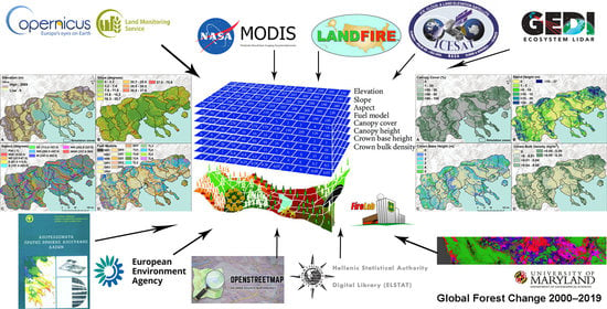
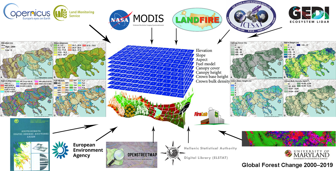
2.1. Data Overview
2.2. Study Area
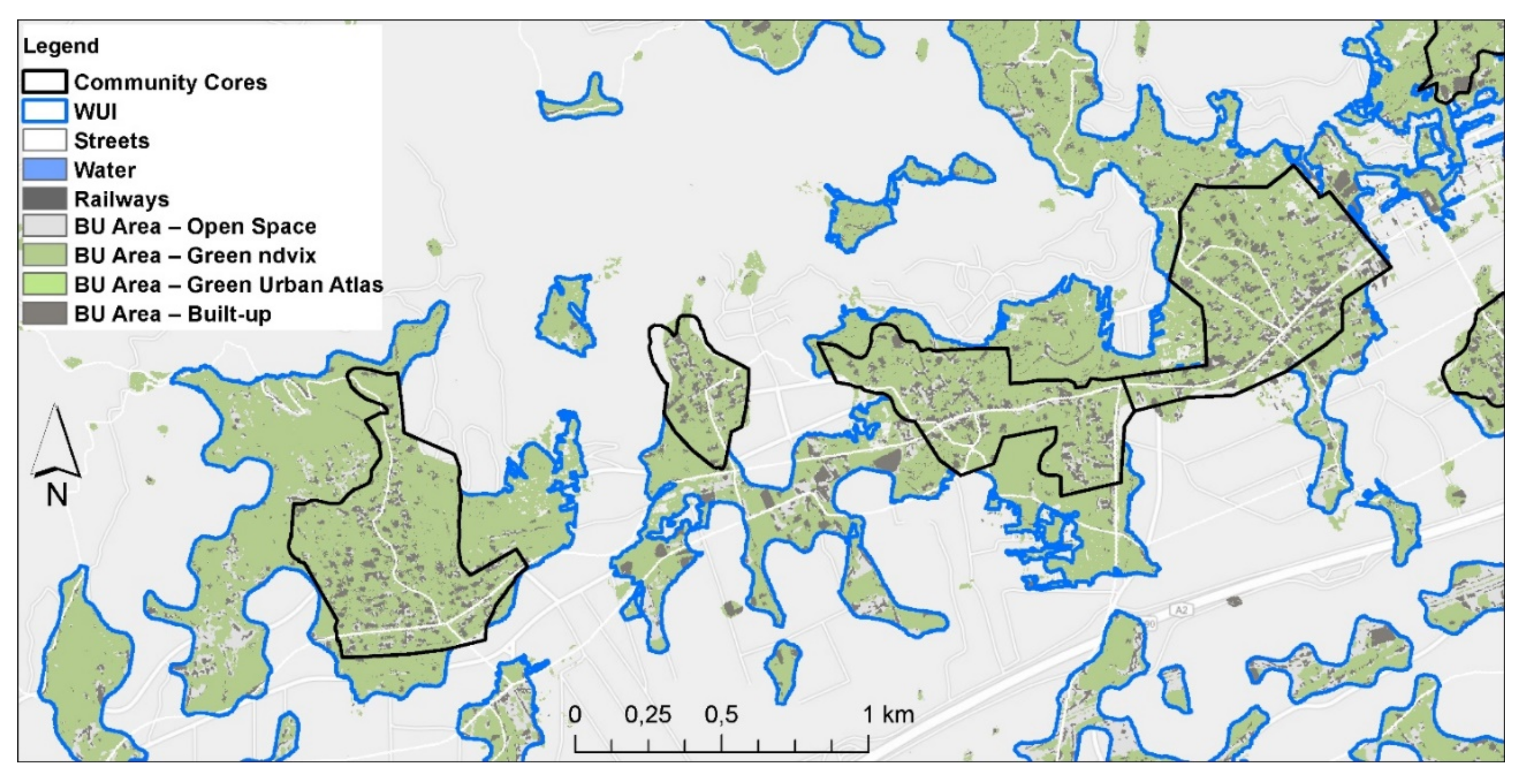
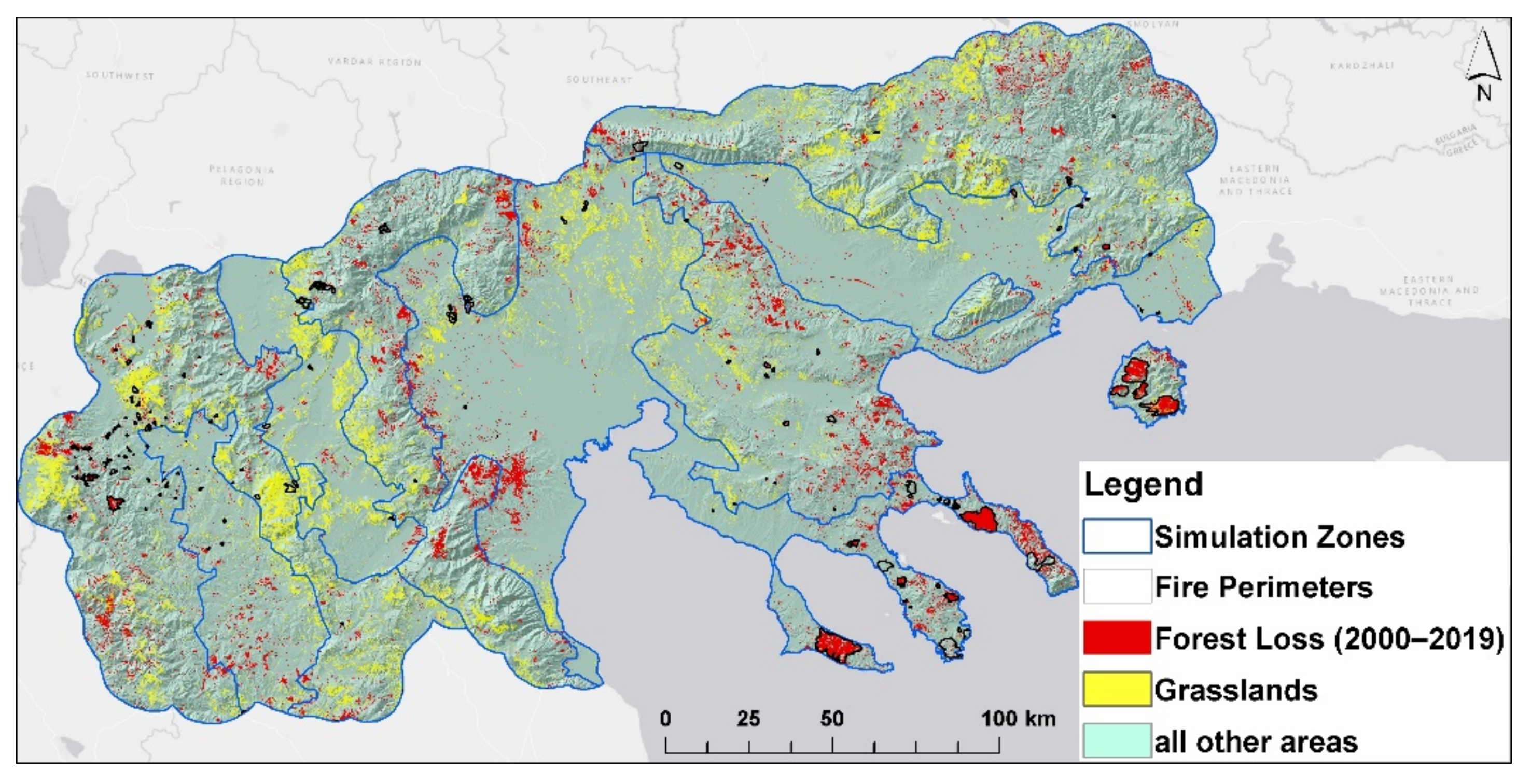
2.3. Vegetation
2.4. Land Tenure and Ownership
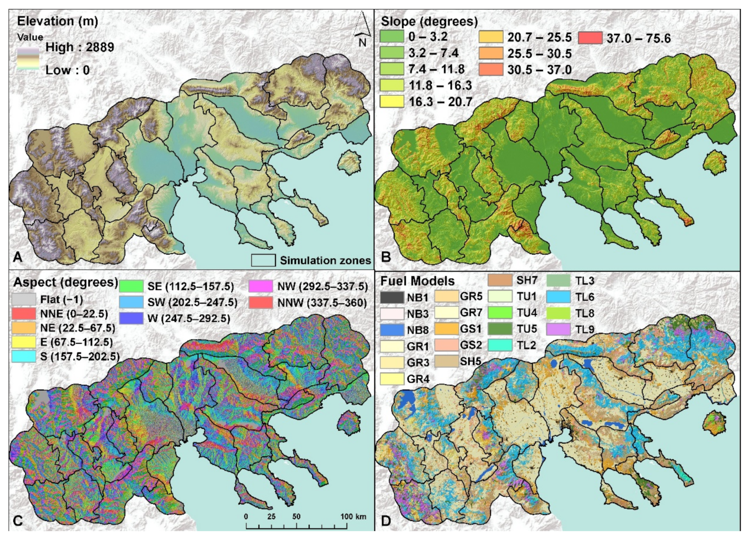
2.5. Topography
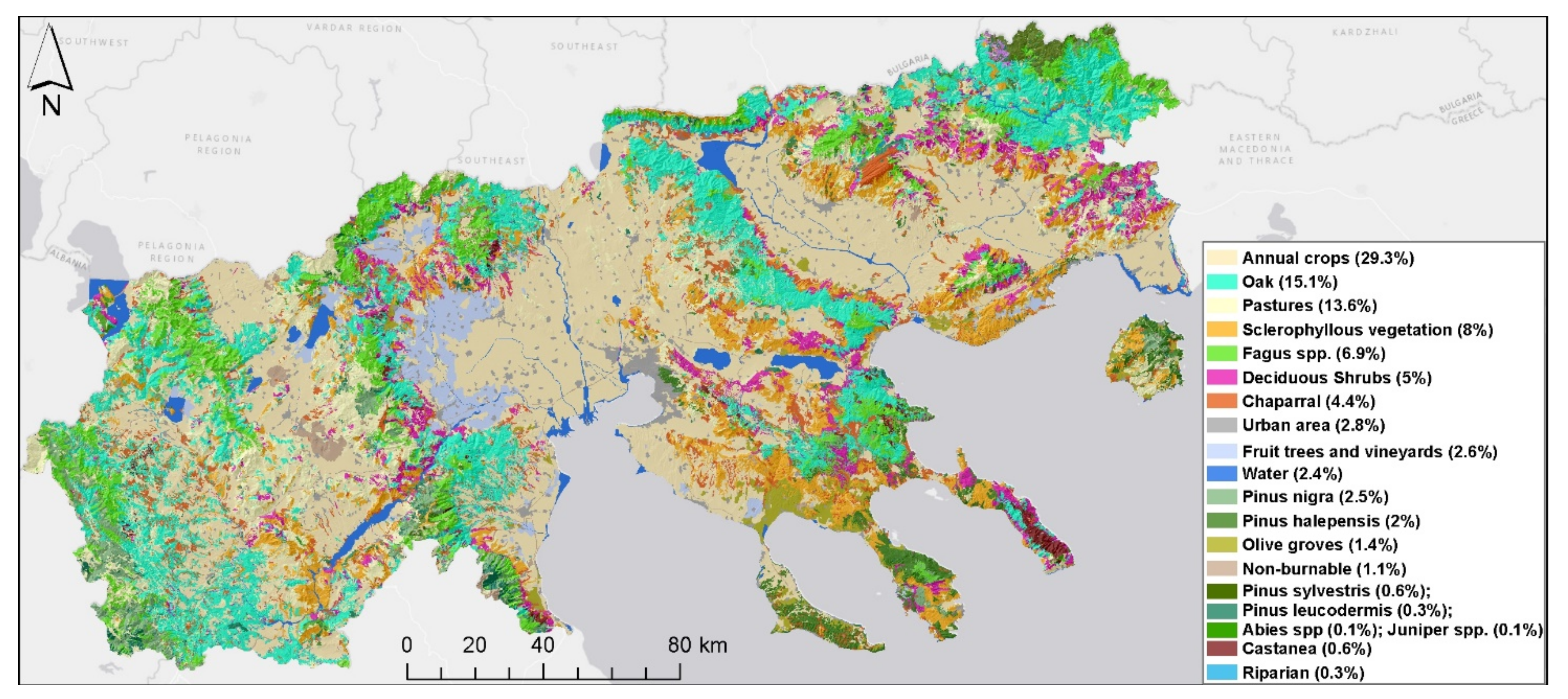
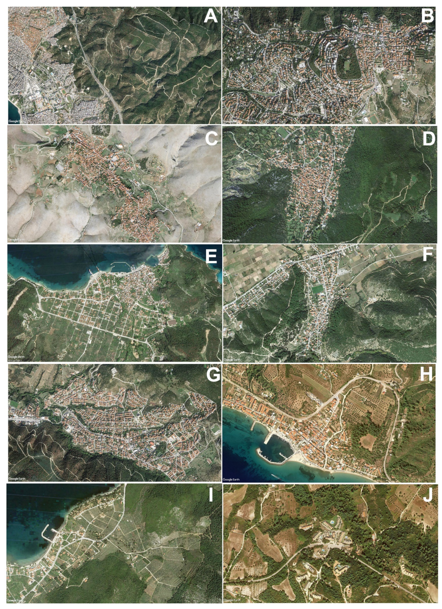
2.6. Community Areas and Wildland-Urban Interface
2.7. Surface Fuel Models
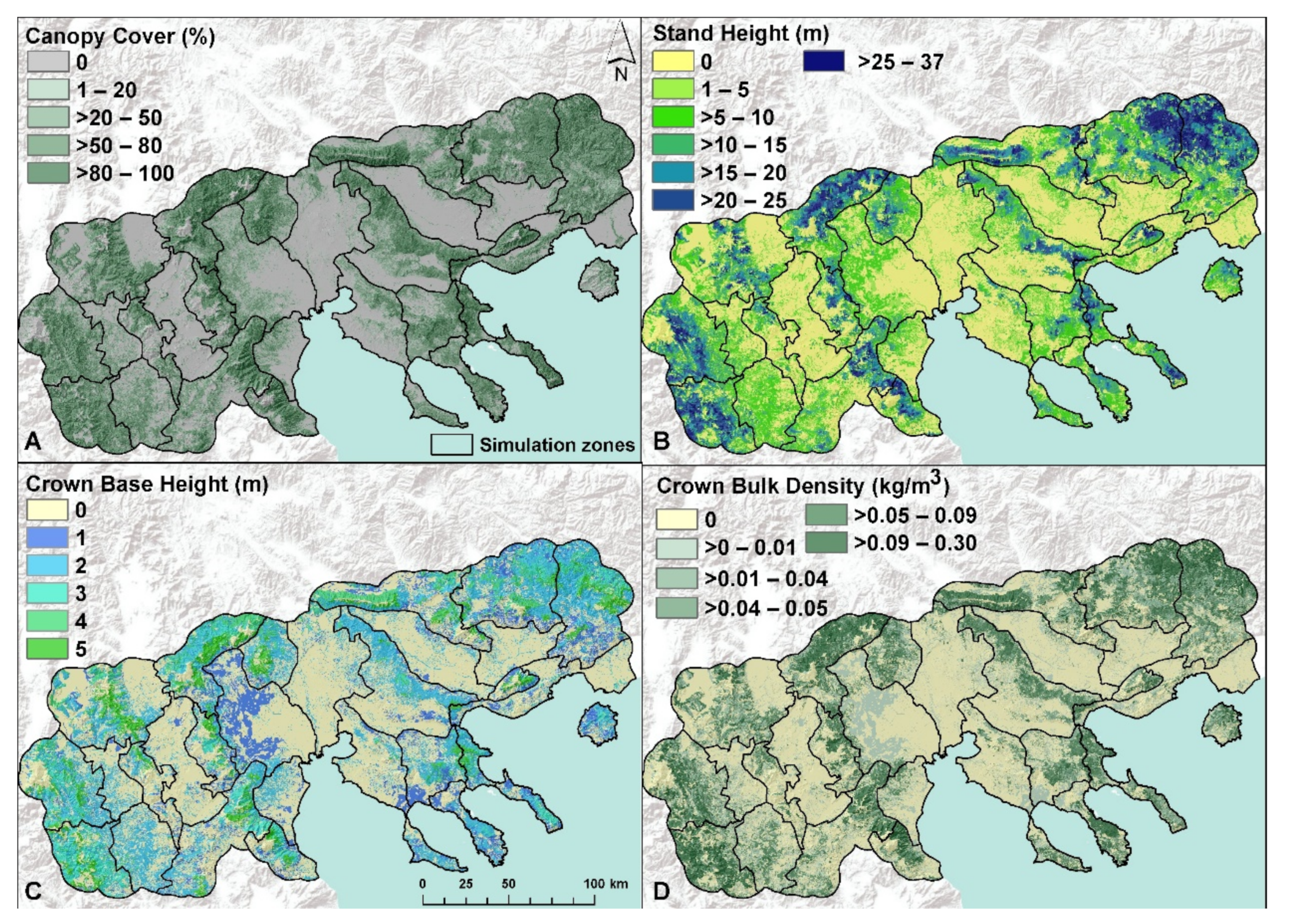
2.8. Forest Canopy Characteristics
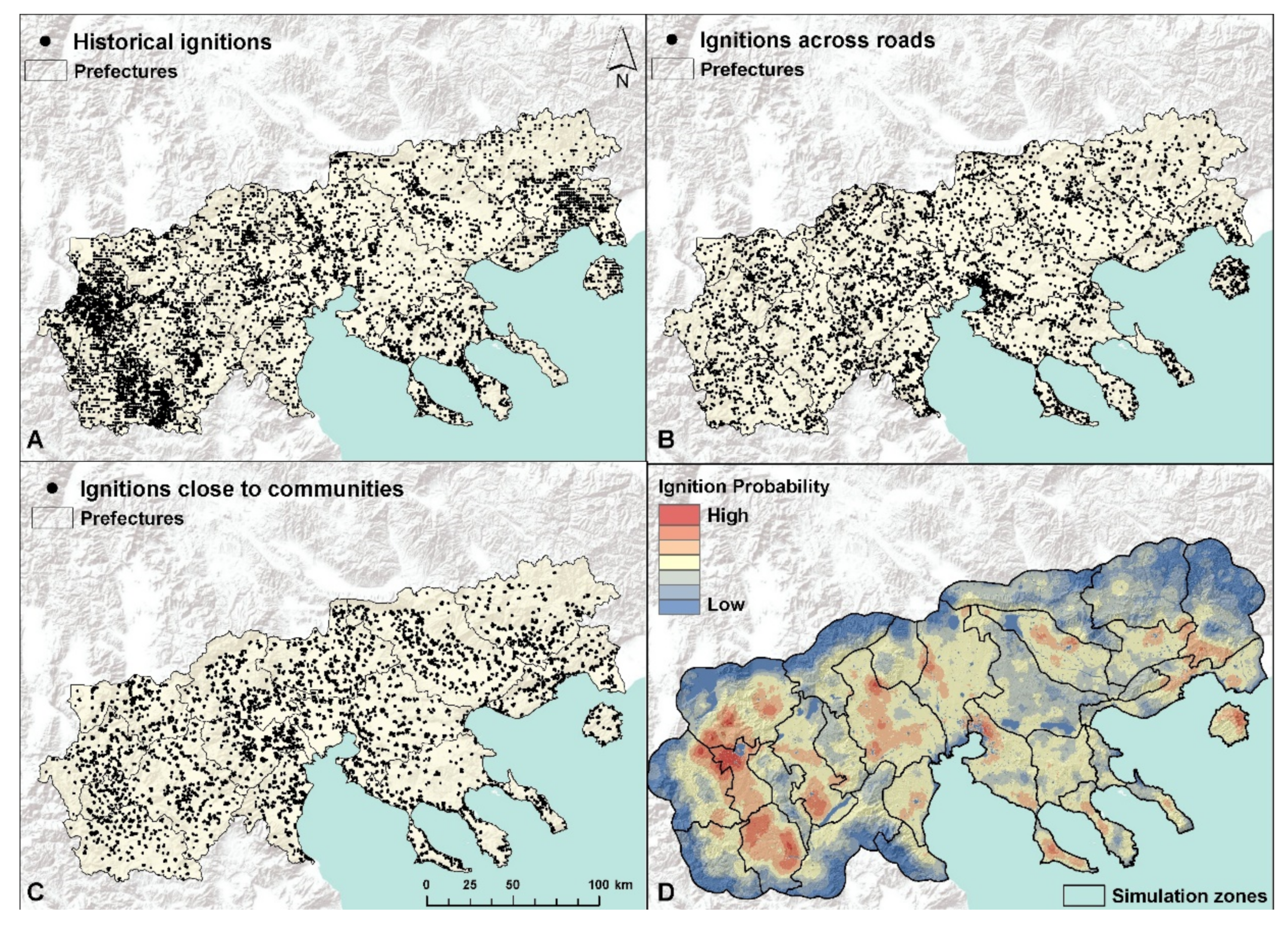
2.9. Probability of Ignition
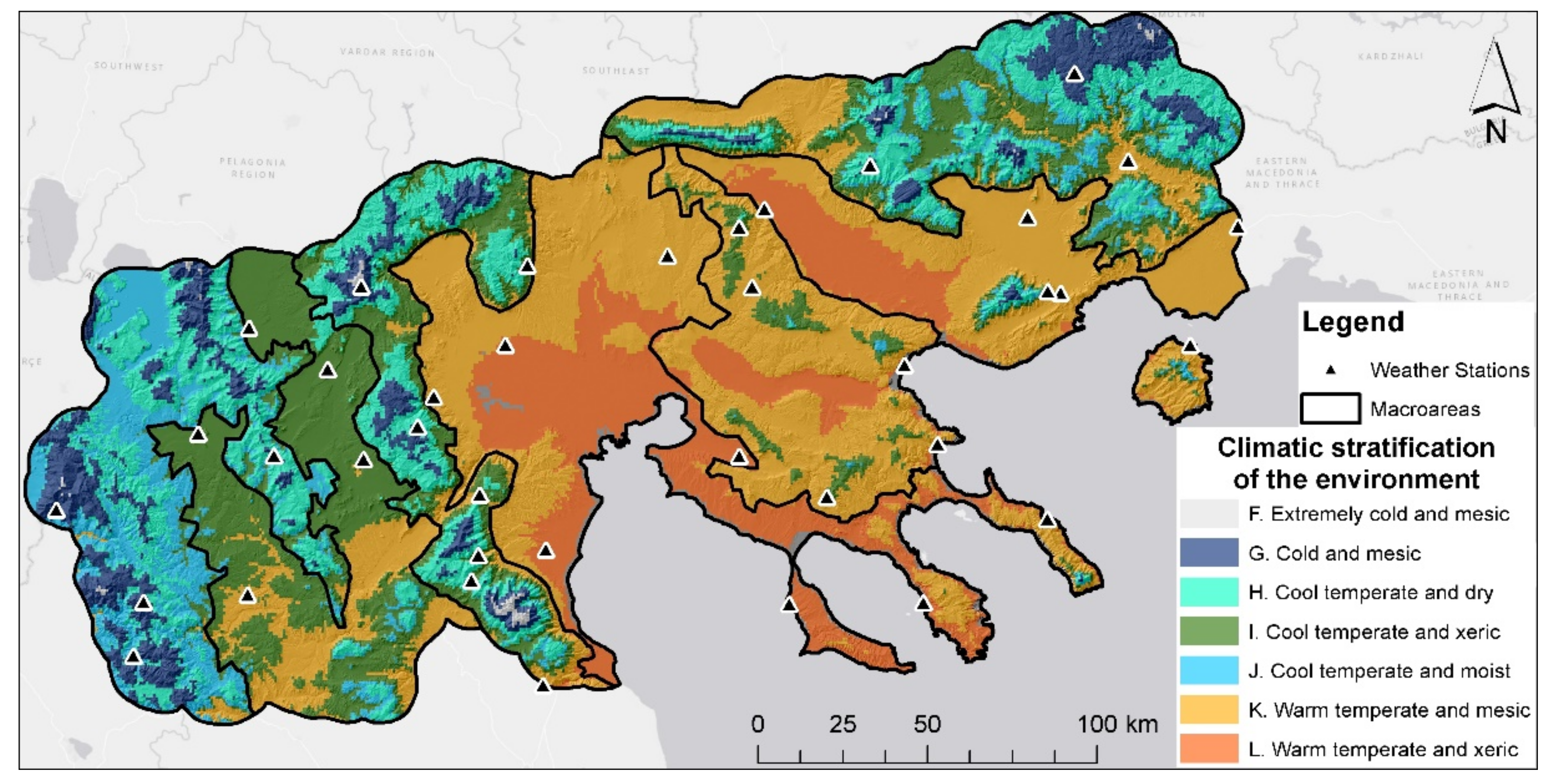
2.10. Weather Data
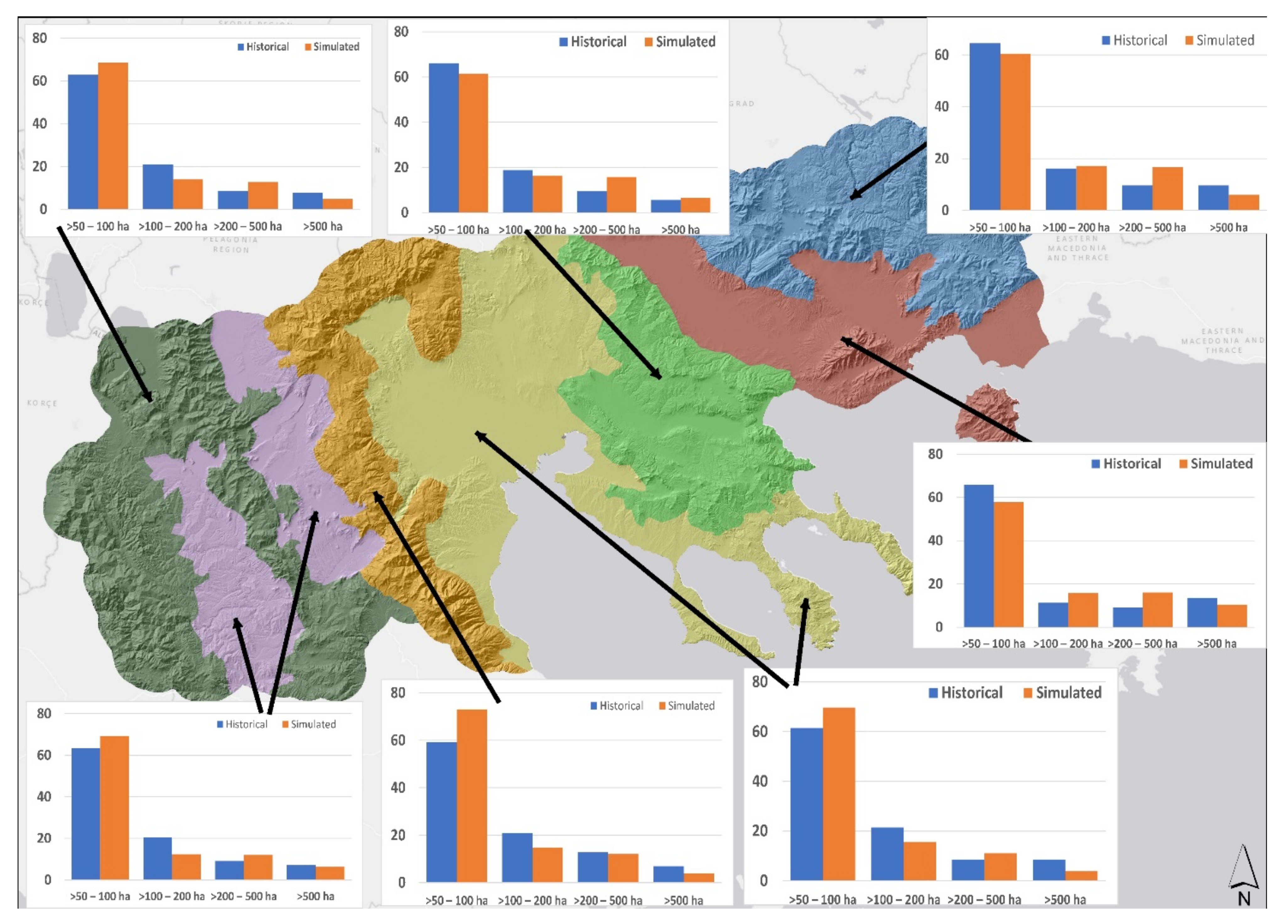
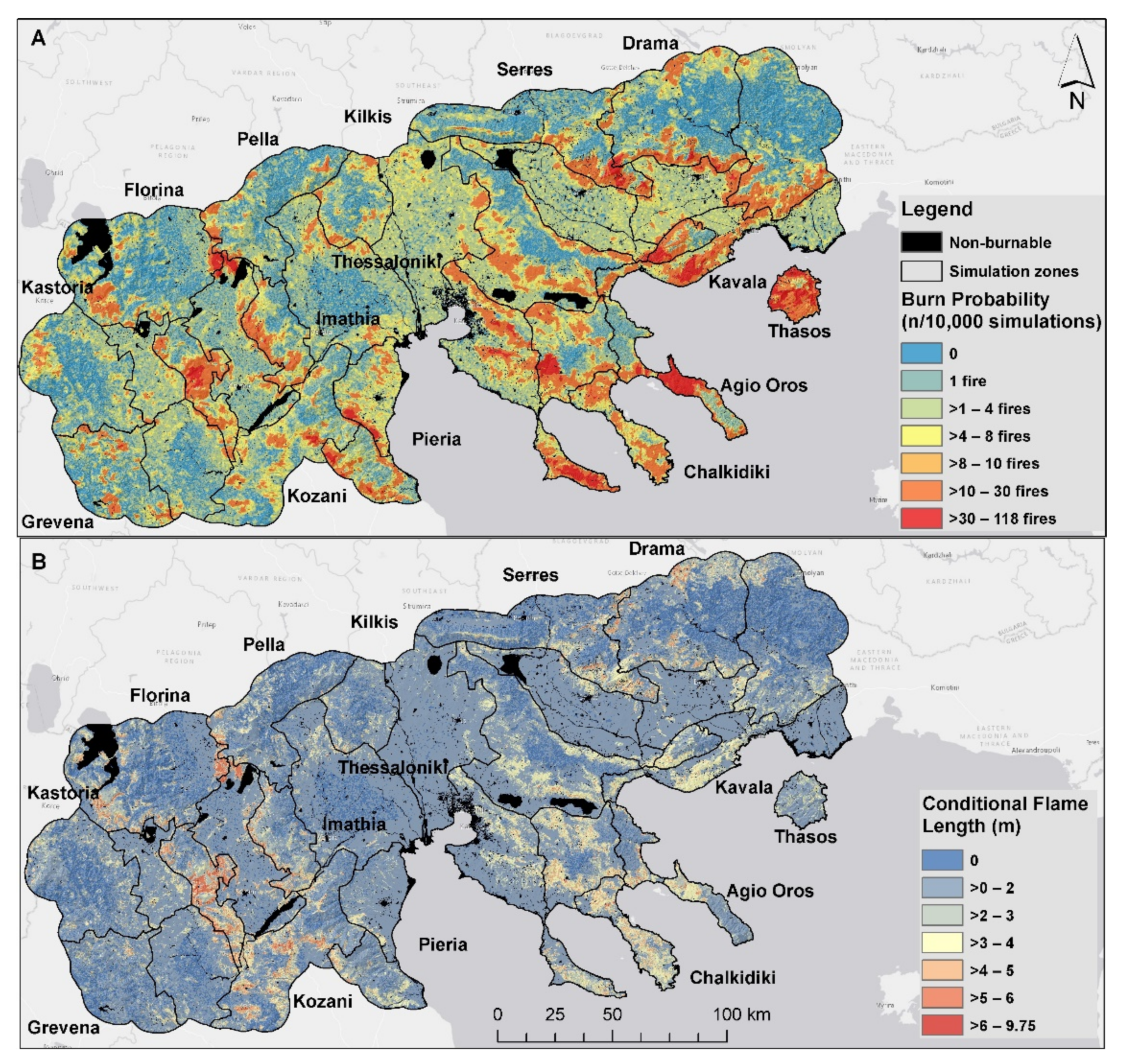
2.11. Wildfire Simulations and Model Validation
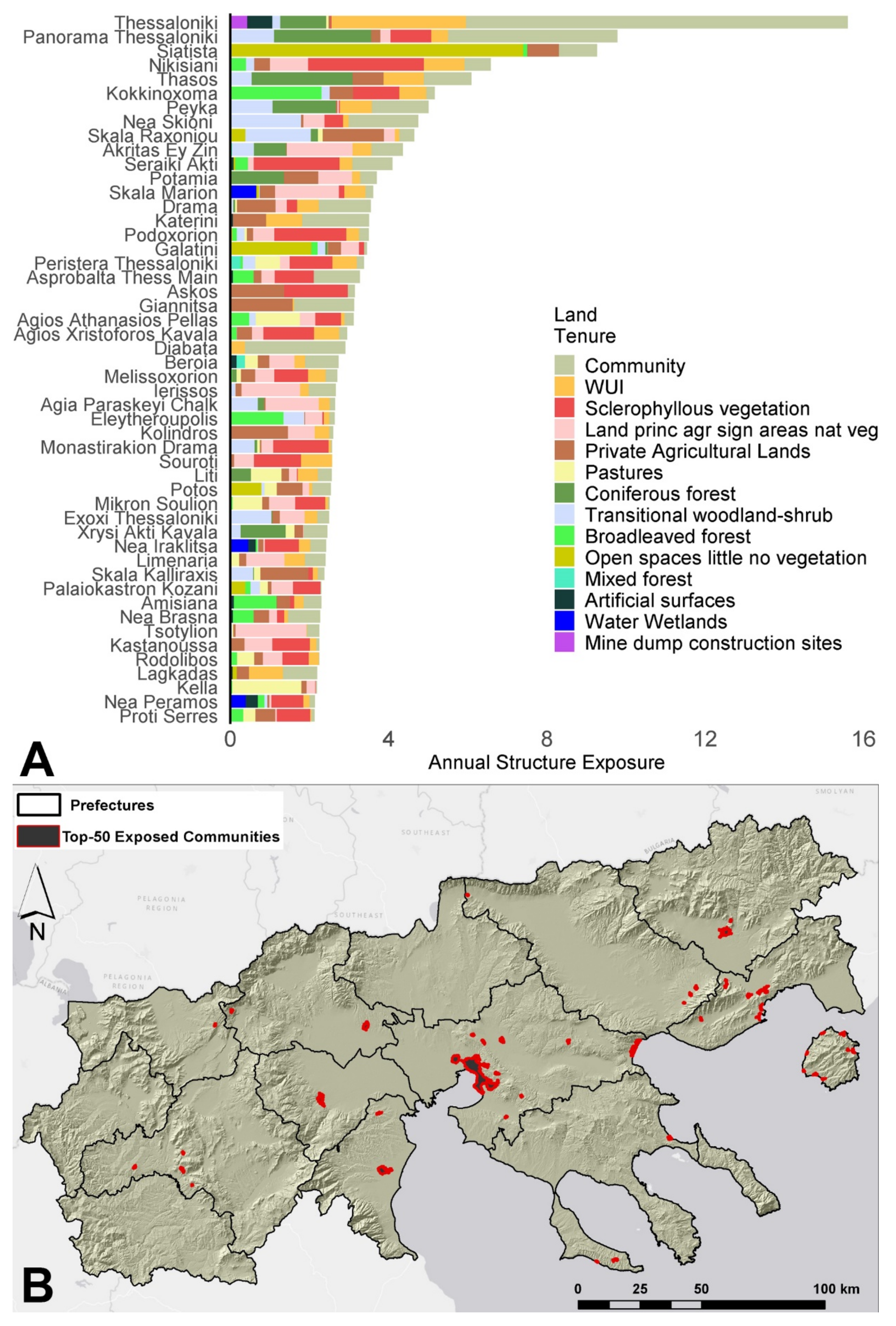
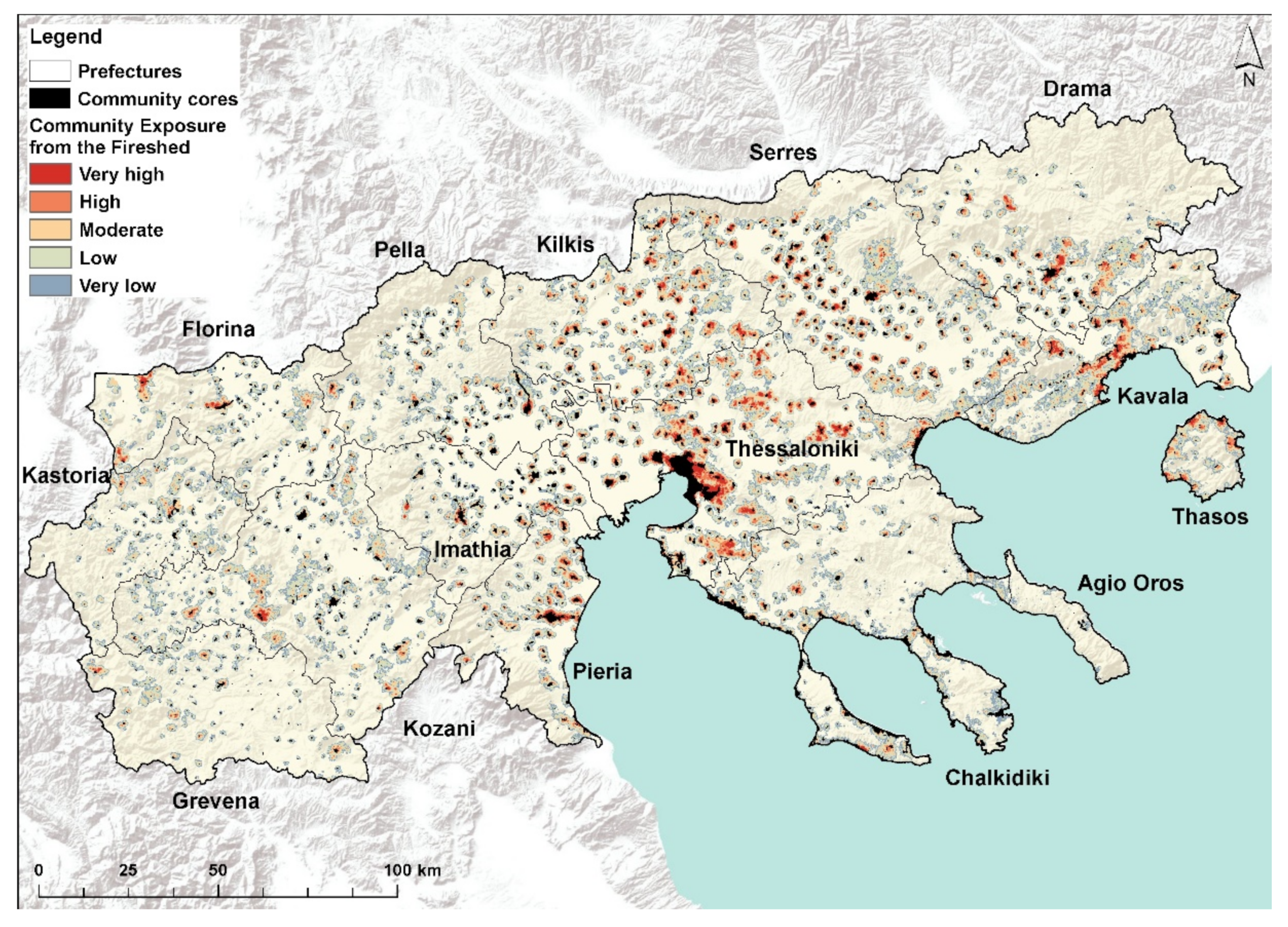
2.12. Community Exposure and Firesheds
2.13. Spatial Scale and Complexity of Wildfire Exposure
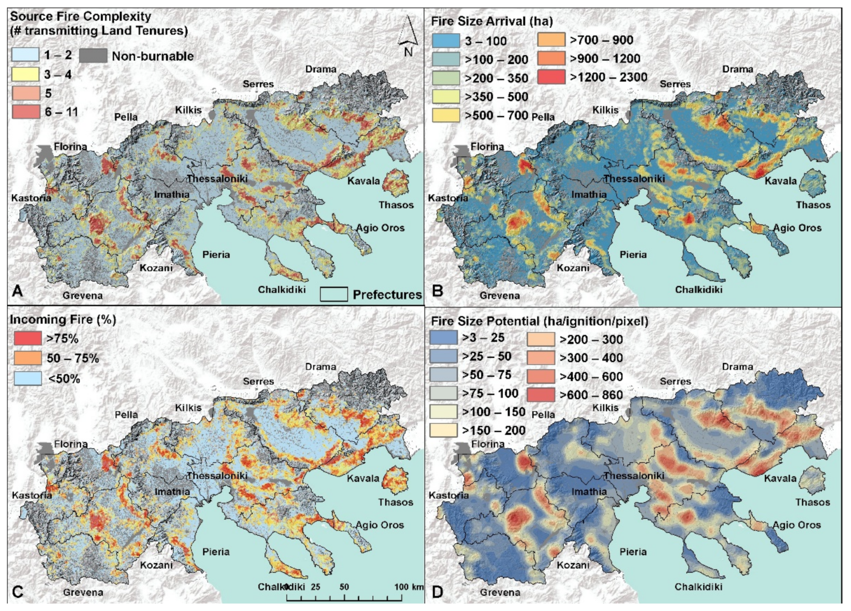
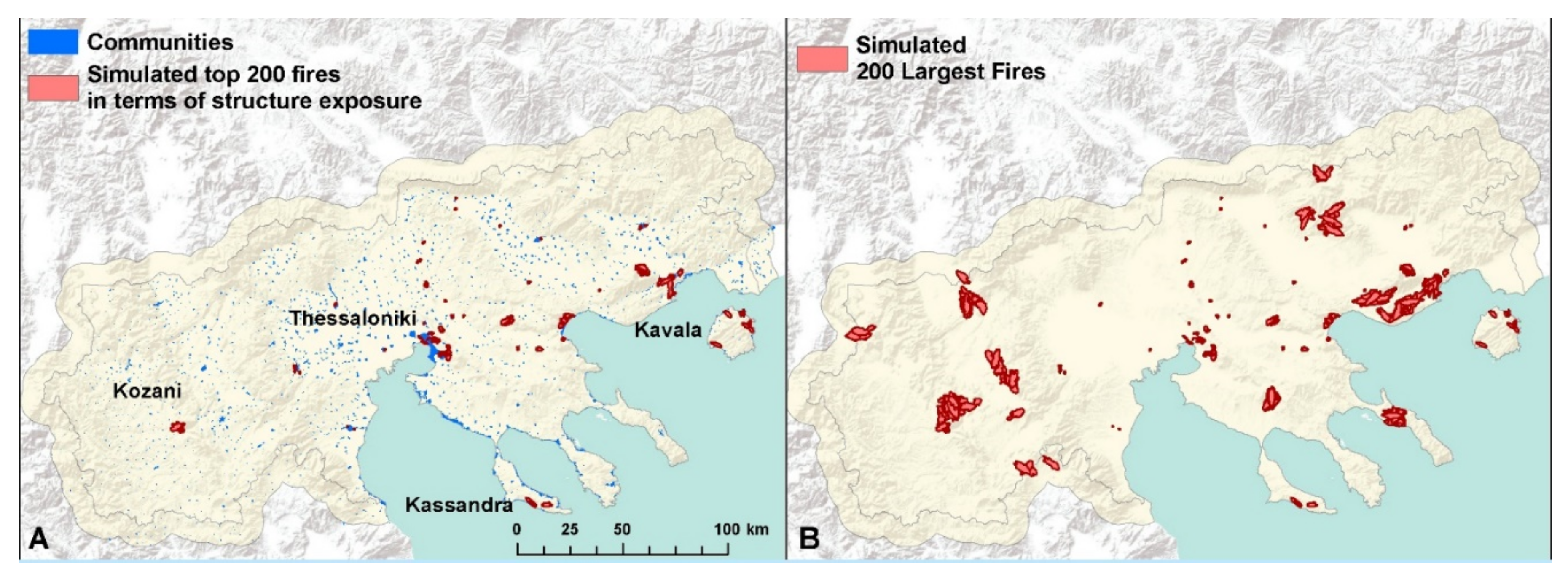
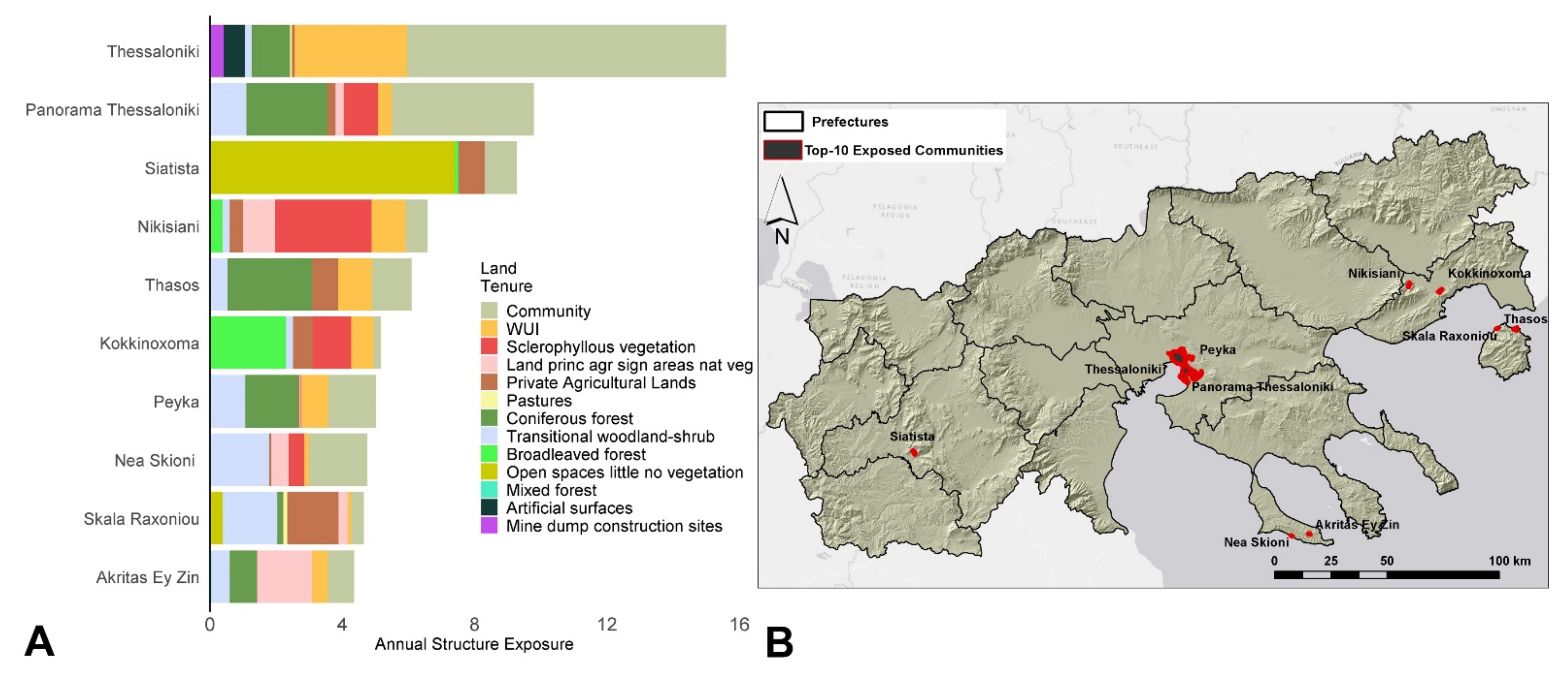
3. Results
4. Discussion
4.1. Application and Expansion to Other Regions
4.2. Improving Community Protection Using Fire Simulation
5. Conclusions
Author Contributions
Funding
Data Availability Statement
Acknowledgments
Conflicts of Interest
Appendix A

| Index | Windspeed (mph) | Direction (Degrees) | Duration (min) | Probability of Selection | Fuel Moisture File (1 h 10 h 100 h LH LW) | Spot Probability |
|---|---|---|---|---|---|---|
| 1 | 19 | 135 | 180 | 0.42 | frakto.fms | 0.25 |
| 1 | 19 | 90 | 180 | 0.16 | frakto.fms | 0.25 |
| 1 | 19 | 68 | 180 | 0.09 | frakto.fms | 0.25 |
| 1 | 19 | 40 | 180 | 0.08 | frakto.fms | 0.25 |
| 1 | 19 | 235 | 180 | 0.1 | frakto.fms | 0.25 |
| 1 | 19 | 113 | 180 | 0.05 | frakto.fms | 0.25 |
| 1 | 19 | 170 | 180 | 0.08 | frakto.fms | 0.25 |
| 1 | 19 | 293 | 180 | 0.02 | frakto.fms | 0.25 |
References
- Palaiologou, P.; Kalabokidis, K.; Ager, A.A.; Day, M.A. Development of comprehensive fuel management strategies for reducing wildfire risk in Greece. Forests 2020, 11, 789. [Google Scholar] [CrossRef]
- Ager, A.A.; Day, M.A.; Short, K.C.; Evers, C.R. Assessing the impacts of federal forest planning on wildfire risk mitigation in the Pacific Northwest, USA. Landsc. Urban Plan. 2016, 147, 1–17. [Google Scholar] [CrossRef] [Green Version]
- Charnley, S.; Kelly, E.C.; Wendel, K.L. All lands approaches to fire management in the Pacific West: A typology. J. For. 2016, 115, 16–25. [Google Scholar] [CrossRef]
- Ager, A.A.; Day, M.A.; Ringo, C.; Evers, C.R.; Alcasena, F.J.; Houtman, R.; Scanlon, M.; Ellersick, T. Development and Application of the Fireshed Registry; RMRS-GTR-425; USDA Forest Service, Rocky Mountain Research Station: Fort Collins, CO, USA, 2021; p. 47. [Google Scholar]
- Duane, A.; Piqué, M.; Castellnou, M.; Brotons, L. Predictive modelling of fire occurrences from different fire spread patterns in Mediterranean landscapes. Int. J. Wildland Fire 2015, 24, 407. [Google Scholar] [CrossRef]
- Costafreda-Aumedes, S.; Comas, C.; Vega-Garcia, C. Spatio-Temporal Configurations of Human-Caused Fires in Spain through Point Patterns. Forests 2016, 7, 185. [Google Scholar] [CrossRef] [Green Version]
- Vacchiano, G.; Foderi, C.; Berretti, R.; Marchi, E.; Motta, R. Modeling anthropogenic and natural fire ignitions in an inner-alpine valley. Nat. Hazards Earth Syst. Sci. 2018, 18, 935–948. [Google Scholar] [CrossRef] [Green Version]
- Elia, M.; D’Este, M.; Ascoli, D.; Giannico, V.; Spano, G.; Ganga, A.; Colangelo, G.; Lafortezza, R.; Sanesi, G. Estimating the probability of wildfire occurrence in Mediterranean landscapes using Artificial Neural Networks. Environ. Impact Assess. Rev. 2020, 85, 106474. [Google Scholar] [CrossRef]
- Marcos, B.; Gonçalves, J.; Alcaraz-Segura, D.; Cunha, M.; Honrado, J.P. Improving the detection of wildfire disturbances in space and time based on indicators extracted from MODIS data: A case study in northern Portugal. Int. J. Appl. Earth Obs. Geoinf. 2019, 78, 77–85. [Google Scholar] [CrossRef]
- Sifakis, N.I.; Iossifidis, C.; Kontoes, C.; Keramitsoglou, I. Wildfire Detection and Tracking over Greece Using MSG-SEVIRI Satellite Data. Remote Sens. 2011, 3, 524–538. [Google Scholar] [CrossRef] [Green Version]
- Li, P.; Xiao, C.; Feng, Z.; Li, W.; Zhang, X. Occurrence frequencies and regional variations in Visible Infrared Imaging Radiometer Suite (VIIRS) global active fires. Glob. Change Biol. 2020, 26, 2970–2987. [Google Scholar] [CrossRef]
- Abatzoglou, J.T.; Balch, J.K.; Bradley, B.A.; Kolden, C.A. Human-related ignitions concurrent with high winds promote large wildfires across the USA. Int. J. Wildland Fire 2018, 27, 377–386. [Google Scholar] [CrossRef]
- Scott, J.H.; Short, K.C.; Finney, M.; Gilbertson-Day, J.; Vogler, K.C. FSim: The Large-Fire Simulator Guide to Best Practices Version 0.3.1; Missoula Fire Sciences Lab: Missoula, MT, USA, 2018. [Google Scholar]
- Bar Massada, A.; Syphard, A.D.; Hawbaker, T.J.; Stewart, S.I.; Radeloff, V.C. Effects of ignition location models on the burn patterns of simulated wildfires. Environ. Model. Softw. 2011, 26, 583–592. [Google Scholar] [CrossRef]
- Finney, M.A. An overview of FlamMap fire modeling capabilities. In Fuels Management-How to Measure Success: Conference Proceedings, Proceedings of the RMRS-P-41, Portland, OR, USA, 28–30 March 2006; Andrews, P.L., Butler, B.W., Eds.; U.S. Department of Agriculture, Forest Service, Rocky Mountain Research Station: Fort Collins, CO, USA; pp. 213–220.
- Finney, M.A. FARSITE: Fire Area Simulator-Model Development and Evaluation; RMRS-RP-4; USDA Forest Service, Rocky Mountain Research Station: Ogden, UT, USA, 1998; p. 47. [Google Scholar]
- Finney, M. Fire Spread Probability (FSPro); USDA Forest Service, Rocky Mountain Research Station, Fire Sciences Laboratory: Missoula, MT, USA, 2002. [Google Scholar]
- Finney, M.A.; McHugh, C.W.; Grenfell, I.C.; Riley, K.L.; Short, K.C. A simulation of probabilistic wildfire risk components for the continental United States. Stoch. Environ. Res. Risk Assess. 2011, 25, 973–1000. [Google Scholar] [CrossRef] [Green Version]
- Ager, A.A.; Evers, C.R.; Day, M.A.; Preisler, H.K.; Barros, A.M.; Nielsen-Pincus, M. Network analysis of wildfire transmission and implications for risk governance. PLoS ONE 2017, 12, e0172867. [Google Scholar] [CrossRef]
- Ager, A.A.; Finney, M.A.; McMahan, A.J.; Cathcart, J. Measuring the effect of fuel treatments on forest carbon using landscape risk analysis. Nat. Hazards Earth Syst. Sci. 2010, 10, 2515–2526. [Google Scholar] [CrossRef]
- Finney, M.A.; Seli, R.C.; McHugh, C.W.; Ager, A.A.; Bahro, B.; Agee, J.K. Simulation of long-term landscape-level fuel treatment effects on large wildfires. Int. J. Wildland Fire 2007, 16, 712–727. [Google Scholar] [CrossRef] [Green Version]
- Barros, A.M.G.; Ager, A.A.; Day, M.A.; Palaiologou, P. Improving long-term fuel treatment effectiveness in the National Forest System through quantitative prioritization. For. Ecol. Manag. 2019, 433, 514–527. [Google Scholar] [CrossRef]
- Salis, M.; Laconi, M.; Ager, A.A.; Alcasena, F.J.; Arca, B.; Lozano, O.; Fernandes de Oliveira, A.; Spano, D. Evaluating alternative fuel treatment strategies to reduce wildfire losses in a Mediterranean area. For. Ecol. Manag. 2016, 368, 207–221. [Google Scholar] [CrossRef]
- Ager, A.A.; Day, M.A.; McHugh, C.W.; Short, K.; Gilbertson-Day, J.; Finney, M.A.; Calkin, D.E. Wildfire exposure and fuel management on western US national forests. J. Environ. Manag. 2014, 145, 54–70. [Google Scholar] [CrossRef]
- Evers, C.; Ager, A.A.; Nielsen-Pincus, M.; Palaiologou, P.; Bunzel, K. Archetypes of community wildfire exposure from national forests in the western US. Landsc. Urban Plan. 2019, 182, 55–66. [Google Scholar] [CrossRef] [Green Version]
- Ager, A.A.; Day, M.A.; Palaiologou, P.; Houtman, R.; Ringo, C.; Evers, C. Cross-Boundary Wildfire and Community Exposure: A Framework and Application in the Western US; RMRS-GTR-392; USDA Forest Service, Rocky Mountain Research Station: Fort Collins, CO, USA, 2019; p. 36. [Google Scholar]
- Ager, A.A.; Day, M.A.; Alcasena, F.J.; Evers, C.R.; Short, K.C.; Grenfell, I. Predicting Paradise: Modeling future wildfire disasters in the western US. Sci. Total Environ. 2021, 784, 147057. [Google Scholar] [CrossRef]
- Ager, A.A.; Houtman, R.; Day, M.A.; Ringo, C.; Palaiologou, P. Tradeoffs between US national forest harvest targets and fuel management to reduce wildfire transmission to the wildland urban interface. For. Ecol. Manag. 2019, 434, 99–109. [Google Scholar] [CrossRef]
- Ager, A.A.; Day, M.A.; Vogler, K. Production possibility frontiers and socioecological tradeoffs for restoration of fire adapted forests. J. Environ. Manag. 2016, 176, 157–168. [Google Scholar] [CrossRef] [Green Version]
- Castellnou, M.; Prat-Guitart, N.; Arilla, E.; Larrañaga, A.; Nebot, E.; Castellarnau, X.; Vendrell, J.; Pallàs, J.; Herrera, J.; Monturiol, M.; et al. Empowering strategic decision-making for wildfire management: Avoiding the fear trap and creating a resilient landscape. Fire Ecol. 2019, 15, 31. [Google Scholar] [CrossRef]
- Calkin, D.E.; Ager, A.A.; Gilbertson-Day, J.; Scott, J.H.; Finney, M.A.; Schrader-Patton, C.; Quigley, T.M.; Strittholt, J.R.; Kaiden, J.D. Wildfire Risk and Hazard: Procedures for the First Approximation; GTR-RMRS-235; USDA Forest Service, Rocky Mountain Research Station: Fort Collins, CO, USA, 2010; p. 62. [Google Scholar]
- Mitsopoulos, I.; Mallinis, G.; Arianoutsou, M. Wildfire risk assessment in a typical Mediterranean wildland—Urban interface of Greece. Environ. Manag. 2015, 55, 900–915. [Google Scholar] [CrossRef]
- Palaiologou, P.; Ager, A.A.; Nielsen-Pincus, M.; Evers, C.; Kalabokidis, K. Using transboundary wildfire exposure assessments to improve fire management programs: A case study in Greece. Int. J. Wildland Fire 2018, 27, 501–513. [Google Scholar] [CrossRef]
- Mallinis, G.; Mitsopoulos, I.; Beltran, E.; Goldammer, J. Assessing Wildfire Risk in Cultural Heritage Properties Using High Spatial and Temporal Resolution Satellite Imagery and Spatially Explicit Fire Simulations: The Case of Holy Mount Athos, Greece. Forests 2016, 7, 46. [Google Scholar] [CrossRef] [Green Version]
- Xofis, P.; Konstantinidis, P.; Papadopoulos, I.; Tsiourlis, G. Integrating Remote Sensing Methods and Fire Simulation Models to Estimate Fire Hazard in a South-East Mediterranean Protected Area. Fire 2020, 3, 31. [Google Scholar] [CrossRef]
- Alcasena, F.J.; Ager, A.A.; Bailey, J.D.; Pineda, N.; Vega-Garcia, C. Towards a comprehensive wildfire management strategy for Mediterranean areas: Framework development and implementation in Catalonia, Spain. J. Environ. Manag. 2019, 231, 303–320. [Google Scholar] [CrossRef]
- Salis, M.; Arca, B.; Del Giudice, L.; Palaiologou, P.; Alcasena-Urdiroz, F.; Ager, A.; Fiori, M.; Pellizzaro, G.; Scarpa, C.; Schirru, M.; et al. Application of simulation modeling for wildfire exposure and transmission assessment in Sardinia, Italy. Int. J. Disaster Risk Reduct. 2021, 58, 102189. [Google Scholar] [CrossRef]
- Oliveira, T.M.; Barros, A.M.G.; Ager, A.A.; Fernandes, P.M. Assessing the effect of a fuel break network to reduce burnt area and wildfire risk transmission. Int. J. Wildland Fire 2016, 25, 619–632. [Google Scholar] [CrossRef]
- Alcasena, F.; Ager, A.; Le Page, Y.; Bessa, P.; Loureiro, C.; Oliveira, T. Assessing wildfire exposure to communities and protected areas in Portugal. Fire 2021, 4, 82. [Google Scholar] [CrossRef]
- Parisien, M.-A.; Dawe, D.A.; Miller, C.; Stockdale, C.A.; Armitage, O.B. Applications of simulation-based burn probability modelling: A review. Int. J. Wildland Fire 2020, 28, 913–926. [Google Scholar] [CrossRef] [Green Version]
- Kelso, J.K.; Mellor, D.; Murphy, M.E.; Milne, G.J. Techniques for evaluating wildfire simulators via the simulation of historical fires using the AUSTRALIS simulator. Int. J. Wildland Fire 2015, 24, 784–797. [Google Scholar] [CrossRef] [Green Version]
- Jahdi, R.; Salis, M.; Darvishsefat, A.A.; Alcasena, F.; Mostafavi, M.A.; Etemad, V.; Lozano, O.M.; Spano, D. Evaluating fire modelling systems in recent wildfires of the Golestan National Park, Iran. Forestry 2016, 89, 136–149. [Google Scholar] [CrossRef] [Green Version]
- Myroniuk, V.; Kutia, M.; J Sarkissian, A.; Bilous, A.; Liu, S. Regional-Scale Forest Mapping over Fragmented Landscapes Using Global Forest Products and Landsat Time Series Classification. Remote Sens. 2020, 12, 187. [Google Scholar] [CrossRef] [Green Version]
- Palaiologou, P.; Kalabokidis, K.; Kyriakidis, P. Forest mapping by geoinformatics for landscape fire behaviour modelling in coastal forests, Greece. Int. J. Remote Sens. 2013, 34, 4466–4490. [Google Scholar] [CrossRef]
- Aragoneses, E.; Chuvieco, E. Generation and Mapping of Fuel Types for Fire Risk Assessment. Fire 2021, 4, 59. [Google Scholar] [CrossRef]
- Engelstad, P.S.; Falkowski, M.; Wolter, P.; Poznanovic, A.; Johnson, P. Estimating Canopy Fuel Attributes from Low-Density LiDAR. Fire 2019, 2, 38. [Google Scholar] [CrossRef] [Green Version]
- Riaño, D.; Chuvieco, E.; Condés, S.; González-Matesanz, J.; Ustin, S.L. Generation of crown bulk density for Pinus sylvestris L. from lidar. Remote Sens. Environ. 2004, 92, 345–352. [Google Scholar] [CrossRef]
- Mielcarek, M.; Stereńczak, K.; Khosravipour, A. Testing and evaluating different LiDAR-derived canopy height model generation methods for tree height estimation. Int. J. Appl. Earth Obs. Geoinf. 2018, 71, 132–143. [Google Scholar] [CrossRef]
- Metzger, M.J.; Bunce, R.G.H.; Jongman, R.H.; Mücher, C.A.; Watkins, J.W. A climatic stratification of the environment of Europe. Glob. Ecol. Biogeogr. 2005, 14, 549–563. [Google Scholar] [CrossRef]
- EEA. Corine Land Cover (CLC) 2018, Version 2020_20u1. Available online: https://land.copernicus.eu/pan-european/corine-land-cover/clc2018 (accessed on 21 February 2022).
- EEA. Nationally Designated Protected Areas (CDDA). Available online: https://www.eea.europa.eu/data-and-maps/data/nationally-designated-areas-national-cdda-15 (accessed on 21 February 2022).
- Mouratidis, A.; Ampatzidis, D. European digital elevation model validation against extensive global navigation satellite systems data and comparison with SRTM DEM and ASTER GDEM in Central Macedonia (Greece). ISPRS Int. J. Geo-Inf. 2019, 8, 108. [Google Scholar] [CrossRef] [Green Version]
- Scott, J.H.; Burgan, R.E. Standard Fire Behavior Fuel Models: A Comprehensive Set for Use with Rothermel’s Surface Fire Spread Model; RMRS-GTR-153; USDA Forest Service, Rocky Mountain Research Station: Fort Collins, CO, USA, 2005; p. 72. [Google Scholar]
- Papanastasis, V.P. Species Structure and Productivity in Grasslands of Northern Greece. In Components of Productivity of Mediterranean-Climate Regions Basic and Applied Aspects, Proceedings of the International Symposium on Photosynthesis, Primary Production and Biomass Utilization in Mediterranean-Type Ecosystems, Kassandra, Greece, 13–15, September 1980; Margaris, N.S., Mooney, H.A., Eds.; Springer Netherlands: Dordrecht, The Netherlands, 1981; pp. 205–217. [Google Scholar]
- Roukos, C.; Koutsoukis, C.; Akrida-Demertzi, K.; Karatassiou, M.; Demertzis, G.; Kandrelis, S. The effect of altitudinal zone on soil properties, species composition and forage production in a subalpine grassland in northwest Greece. Appl. Ecol. Environ. Res. 2017, 15, 609–626. [Google Scholar] [CrossRef]
- Hansen, M.C.; Potapov, P.V.; Moore, R.; Hancher, M.; Turubanova, S.A.; Tyukavina, A.; Thau, D.; Stehman, S.V.; Goetz, S.J.; Loveland, T.R.; et al. High-Resolution Global Maps of 21st-Century Forest Cover Change. Science 2013, 342, 850–853. [Google Scholar] [CrossRef] [Green Version]
- Dubayah, R.O.; Luthcke, S.B.; Sabaka, T.J.; Nicholas, J.B.; Preaux, S.; Hofton, M.A. GEDI L3 Gridded Land Surface Metrics, Version 1; ORNL DAAC: Oak Ridge, TN, USA, 2021. [Google Scholar]
- Simard, M.; Pinto, N.; Fisher, J.B.; Baccini, A. Mapping forest canopy height globally with spaceborne lidar. J. Geophys. Res. Biogeosci. 2011, 116, G04021. [Google Scholar] [CrossRef] [Green Version]
- Keane, R.E.; Mincemoyer, S.A.; Schmidt, K.M.; Long, D.G.; Garner, J.L. Mapping Vegetation and Fuels for Fire Management on the Gila National Forest Complex, New Mexico; US Department of Agriculture, Forest Service, Rocky Mountain Research Station: Ogden, UT, USA, 2000; p. 126. [Google Scholar]
- Koutsias, N.; Balatsos, P.; Kalabokidis, K. Fire occurrence zones: Kernel density estimation of historical wildfire ignitions at the national level, Greece. J. Maps 2014, 10, 630–639. [Google Scholar] [CrossRef] [Green Version]
- Zambon, I.; Cerdà, A.; Cudlin, P.; Serra, P.; Pili, S.; Salvati, L. Road Network and the Spatial Distribution of Wildfires in the Valencian Community (1993–2015). Agriculture 2019, 9, 100. [Google Scholar] [CrossRef] [Green Version]
- Mobley, W. Effects of changing development patterns and ignition locations within Central Texas. PLoS ONE 2019, 14, e0211454. [Google Scholar] [CrossRef]
- Ager, A.A.; Bunzel, K.; Day, M.A.; Evers, C.; Palaiologou, P. XFire: Geospatial Framework for Characterizing Transboundary Wildfire Risk to Communities, Unpublished Report. 2015.
- Ager, A.A.; Palaiologou, P.; Evers, C.R.; Day, M.A.; Barros, A.M.G. Assessing transboundary wildfire exposure in the southwestern United States. Risk Anal. 2018, 38, 2105–2127. [Google Scholar] [CrossRef] [Green Version]
- Vaillant, N.M.; Ager, A.A.; Anderson, J. ArcFuels10 System Overview; PNW-GTR-875; USDA Forest Service, Pacific Northwest Reseach Station: Portland, OR, USA, 2013. [Google Scholar]
- Scott, J.H.; Reinhardt, E.D. Stereo Photo Guide for Estimating Canopy Fuel Characteristics in Conifer Stands; RMRS-GTR-145; USDA Forest Service, Rocky Mountain Research Station: Fort Collins, CO, USA, 2005. [Google Scholar]
- EFFIS. European Forest Fire Information System. Available online: https://effis.jrc.ec.europa.eu/ (accessed on 21 February 2022).
- Heinsch, F.A.; Andrews, P.L. BehavePlus Fire Modeling System, Version 5.0: Design and Features; Gen. Tech. Rep. RMRS-GTR-249; U.S. Department of Agriculture, Forest Service, Rocky Mountain Research Station: Fort Collins, CO, USA, 2010; p. 111. [Google Scholar]
- OSMF. OpenStreetMap. Available online: https://www.openstreetmap.org/ (accessed on 21 February 2022).
- Microsoft. Computer Generated Building Footprints for the United States GitHub Repository. Available online: https://github.com/Microsoft/USBuildingFootprints (accessed on 21 February 2022).
- Miller, C.; Ager, A.A. A review of recent advances in risk analysis for wildfire management. Int. J. Wildland Fire 2013, 22, 1–14. [Google Scholar] [CrossRef] [Green Version]

| Fuel Model Code | Description | Area (ha) | % | Fuel Model Code | Description | Area (ha) | % |
|---|---|---|---|---|---|---|---|
| GR1 | Short, sparse dry climate grass | 1,165,654 | 27.3 | GR7 | High load, dry climate grass | 115,602 | 2.7 |
| TL6 | Moderate load broadleaf litter | 709,885 | 16.6 | GR4 | Moderate load, dry climate grass | 47,621 | 1.1 |
| SH5 | High load, dry climate shrub | 583,186 | 13.7 | TL2 | Low load broadleaf litter | 34,401 | 0.8 |
| GS1 | Low load, dry climate grass-shrub | 479,701 | 11.2 | SH7 | Very high load, dry climate shrub | 29,356 | 0.7 |
| GS2 | Moderate load, dry climate grass-shrub | 296,218 | 6.9 | GR5 | Low load, humid climate grass | 24,881 | 0.6 |
| TU1 | Low load dry climate timber-grass-shrub | 212,617 | 5.0 | GR3 | Low load, very coarse, humid climate grass | 18,437 | 0.4 |
| TL9 | Very high load broadleaf litter | 193,936 | 4.5 | TL3 | Moderate load conifer litter | 8615 | 0.2 |
| NB | Non-burnable | 185,784 | 4.3 | TU4 | Dwarf conifer with understory | 5216 | 0.1 |
| TU5 | Very high load, dry climate timber-shrub | 157,942 | 3.7 | TL8 | Long-needle litter | 2848 | 0.1 |
| Fuel Model Class | Not Burned (25% of the Study Area) | Burned Once (17% of the Study Area) |
|---|---|---|
| Non-burnable | 13% | 0% |
| Grass | 17% | 39% |
| Grass-shrub or Chaparral | 8% | 18% |
| Timber-Understory | 10% | 11% |
| Timber-Litter | 52% | 32% |
| Sum | 100% | 100% |
| Burn Probability (percentage of total area affected) | ||||
| No fire | 1 fire | 2–10 fires | 11–30 fires | >30 Fires |
| 25% | 17% | 42% | 14% | 2% |
| Conditional Flame Length (percentage of total area affected) | ||||
| 0–2 m | 2–3 m | >3 m | ||
| 77% | 9% | 14% | ||
| Source Complexity Index (percentage of total area affected) | ||||
| 1–2 Land Tenures | 3–4 Land Tenures | >5 Land Tenures | ||
| 60% | 25% | 15% | ||
| Structure exposure (percentage of total study area) | ||||
| Low and Very Low | Moderate | High | Very High | |
| 19% | 4.3% | 2.6% | 1.3% | |
| Levels of Exposure and Distances to Community Boundaries | ||||
| Very Low | Low | Moderate | High | Very High |
| 3.6 km | 2.9 km | 2.3 km | 1.8 km | 1.1 km |
Publisher’s Note: MDPI stays neutral with regard to jurisdictional claims in published maps and institutional affiliations. |
© 2022 by the authors. Licensee MDPI, Basel, Switzerland. This article is an open access article distributed under the terms and conditions of the Creative Commons Attribution (CC BY) license (https://creativecommons.org/licenses/by/4.0/).
Share and Cite
Palaiologou, P.; Kalabokidis, K.; Day, M.A.; Ager, A.A.; Galatsidas, S.; Papalampros, L. Modelling Fire Behavior to Assess Community Exposure in Europe: Combining Open Data and Geospatial Analysis. ISPRS Int. J. Geo-Inf. 2022, 11, 198. https://doi.org/10.3390/ijgi11030198
Palaiologou P, Kalabokidis K, Day MA, Ager AA, Galatsidas S, Papalampros L. Modelling Fire Behavior to Assess Community Exposure in Europe: Combining Open Data and Geospatial Analysis. ISPRS International Journal of Geo-Information. 2022; 11(3):198. https://doi.org/10.3390/ijgi11030198
Chicago/Turabian StylePalaiologou, Palaiologos, Kostas Kalabokidis, Michelle A. Day, Alan A. Ager, Spyros Galatsidas, and Lampros Papalampros. 2022. "Modelling Fire Behavior to Assess Community Exposure in Europe: Combining Open Data and Geospatial Analysis" ISPRS International Journal of Geo-Information 11, no. 3: 198. https://doi.org/10.3390/ijgi11030198
APA StylePalaiologou, P., Kalabokidis, K., Day, M. A., Ager, A. A., Galatsidas, S., & Papalampros, L. (2022). Modelling Fire Behavior to Assess Community Exposure in Europe: Combining Open Data and Geospatial Analysis. ISPRS International Journal of Geo-Information, 11(3), 198. https://doi.org/10.3390/ijgi11030198