Abstract
Building fire is a complex geographic process related to the indoor spatial environment, a smart spatial data model can accurately describe the spatial-temporal information of a building fire scene, which is important for modeling a fire process. With the development of fire dynamics and computer science, many building fire models have been proposed and widely used. However, the spatial representation of these models is relatively weak. In this study, a fire process modeled via the Fire Dynamics Simulator (FDS) and the requirements of a spatial data model are initially analyzed. Then, a new spatial data model named the Combinatorial Spatial Data Model (CSDM) is combined with Geographic Information System (GIS). The key features of the CSDM, which include spatial, semantic, topological, event and state representations of a building fire scene modeled via the CSDM are subsequently presented. In addition, the Unified Modeling Language (UML) class diagram of the CSDM is also presented, and then experiments with a simplified building are conducted as a CSDM implementation case. A method of transferring data from the CSDM to FDS and a building fire analysis approach using the CSDM are subsequently proposed.
1. Introduction
Building fires are frequent and common accidents that threaten public safety and social development. Hence, the intelligent management of building fires has always constituted a research focus [1,2]. With the development of research on the corresponding mechanisms, various building fire models have been proposed with a high reliability [3,4,5] and building fire simulation with these models to support a smarter analysis have been widely used in building fire management. Three main applications of building fire simulation and analysis can be identified. The first is to assess the building fire risk [6]. Building fire simulation and crowd simulation are the two most important bases for this assessment. The second is to perform a route analysis for a crowd or firefighters [7]. The third is to develop a building fire training simulator based on virtual reality (VR) and Geographic Information System (GIS) [8].
A variety of data, such as architectural components, indoor firefighting facilities, and environmental parameters, are all needed in a building fire simulation. Therefore, how to integrate these data into a building fire model has become an import component for building fire simulations. At present, one of the most commonly used building fire models is the Fire Dynamics Simulator (FDS) developed and maintained by the U.S. National Institute of Standards and Technology (NIST) [4]. To date, the FDS has been widely used in building fire management (e.g., fire assessments and virtual drilling) [9,10]. However, whereas substantial research has been conducted on transferring data from building information modeling (BIM) and GIS to FDS with regard to the geometric information of buildings [11,12], which has heretofore represented the main focus, other information (e.g., semantic and topological information) has received much less consideration. In addition, the output of the FDS cannot support smart building fire analysis directly. In this context, the design of a spatial data model in combination with FDS for building fire simulation has great significance.
The approach employed to model building objects forms the foundation of the integration of building fire information. Consequently, research on this topic is always the focus in the domains of GIS and architecture, engineering, and construction (AEC) [13,14,15]. Building information modeling (BIM), a digital representation of the physical and functional characteristics of a facility, is a common way of modeling building objects in AEC. Although the rich information of building objects (e.g., their geometries, spatial relationships and attributes) makes BIM an important source of data for building fire simulation and analysis, the semantic information of building fire objects (e.g., fire doors) and the dynamic behaviors of these objects have received substantially less consideration. In addition, while the fundamental purpose of BIM is to model the entire process from building design to construction management, information will inevitably be either redundant or missing when BIM is applied to building fire simulation and analysis. The Open Geospatial Consortium (OGC), an international nonprofit organization committed to providing open quality standards for the global geospatial community, has also published City Geography Markup Language (CityGML) and Indoor Geography Markup Language (IndoorGML) to describe three-dimensional (3D) building information. Although the geometrical and semantic representations of building objects are defined in CityGML [14], the critical information associated with building fire simulation and analysis (e.g., features related to indoor spaces and topological representations) are lacking. IndoorGML is a complementary standard to CityGML and the Industry Foundation Classes (IFC) that supports location-based services (LBS) for indoor navigation [15]. The topological representation (only the association relationship) between building objects has been described with a node relation graph (NRG). With IndoorGML, search and rescue route analysis for firefighters considering smoke hazard has also been performed [7]. Besides the above, some other data models for building fire safety or emergency response have also been proposed [16,17], and the information (geometry information, topological information or semantic information) of those models are extend with IndoorGML or IFC.
The objective of this article is to develop a new spatial data model named the Combinatorial Spatial Data Model (CSDM) with GIS for building fire simulation and analysis and provide more intelligent support for building fire emergency management and decision-making. The specific objectives are as follows: (1) the modeling method for a building fire scene is first analyzed. Then, via the application of building fire simulation and analysis, the requirements of the spatial data model for building fire simulation and analysis are discussed. (2) Then, based on the method of modeling building objects in GIS and BIM, the CSDM is designed to describe the geometry, semantics, topology, event and state of a building fire scene. In addition, a method for integrating the CSDM into building fire simulation and analysis is proposed. (3) Finally, an experiment for a specific case with the CSDM is implemented, and the usability of the proposed model is analyzed.
2. Modeling a Virtual Building Fire with the Fire Dynamics Simulator (FDS)
By using a readable input file (*.fds) and executing the statements within it, the FDS can dynamically simulate a virtual building fire [4]. The statements in the input file can be categorized into simulation parameters (e.g., the simulation time, initial temperature and mesh size), output parameters (e.g., the file type and data type), information regarding building objects (e.g., geometric and boundary conditions), and control logic information, among others. A considerable amount of the work involved in writing an input file lies in specifying the building object information.
Three main name-list groups (OBST, HOLE, and VENT) are introduced into the FDS to model building objects, such as doors, walls, and floors. OBST is used to define obstructions, such as walls, pillars and other architectural components, whereas HOLE is used to carve a hole into an existing obstruction, and it can also be used to define a window or door. The geometry of OBST and HOLE involves rectangular, axis-aligned solids defined by two points. VENT is used to prescribe planes adjacent to obstructions or external walls. Two of the six coordinates in VENT must be equal, thereby denoting a plane as opposed to a solid. A ventilation system in a building, such as a diffuser or a return, is a typical VENT plane. VENT can also be used to apply a particular boundary condition to a rectangular patch on a solid surface. A fire, for example, is usually created by first generating a solid obstruction and then specifying a vent somewhere on one of the faces of the solid in addition to the thermal and combustion properties of the fuel. OBST, HOLE and VENT can also be combined with other name-list groups (e.g., REAC, SURF, and MATL) to describe the thermochemical properties of building objects. Almost all devices in the FDS (e.g., smoke detectors, sprinklers, and thermocouples) are designated via the DEVC name-list group. In addition, advanced functionalities and properties are accommodated via additional name-list groups called CTRL (Control) and PROP (Properties). The geometries of most devices in the FDS are given by a triplet (XYZ) of real numbers. The device parameters vary based on the type. With CTRL, DEVC can be used to control various actions, such as creating and removing obstructions or activating and deactivating fans and vents. In other words, with DEVC and CTRL, the FDS possesses a preliminary ability to describe an event.
Although the FDS has the ability to model and simulate a virtual building fire, the FDS was designed primarily to study fire phenomena only, whereas it cannot support building fire analysis directly. In addition, it is difficult to describe information, achieve accurate spatial computations and provide real-world visualizations for building fire management using the FDS due to its insufficient semantic representations and its simplified geometries of building objects. Consequently, some software (e.g., Pathfinder) have been developed with the FDS output data to provide partial support for building fire management [18]. However, the problems of sharing information and integrating functional modules still exist in this software, making it difficult to support building fire management in a cohesive manner.
To intelligently analyze a building fire, the combustion products of a building fire as well as the impact of the fire on buildings and crowds must be considered. In particular, all the elements related to a building fire (building environment, indoor crowds, etc.) must be considered in the spatial data model for building fire simulation and analysis. That is, the spatial data model requirements for building fire simulation and analysis must include the entire building fire scene, and the following four considerations must be satisfied. First, semantic information on the architectural components (e.g., stair, room and floor), indoor space (e.g., room and corridor) and fire thematic space (e.g., fire compartment) must be described, which is useful for analyzing the fire according to different spatial units. Second, the spatial associations among the fire, crowd and building elements must be given. Third, the topological relationship between geographic objects in a building fire scene must be described and the corresponding routing algorithm must also be provided. Fourth, the state of the geographic objects in the fire scene must be described.
3. Combinatorial Spatial Data Model
3.1. Model Architecture
The CSDM includes four parts: semantic representations, geometric representations, topological representations, and event and state representations (Figure 1). The architecture underlying building fire simulation and analysis with the CSDM is as follows: (1) with the processing and transferring of data, a building fire scene can be modeled with source data, (2) the data of a building fire scene can be transferred to the FDS to simulate the dynamics of a virtual building fire, (3) through data transfer, the FDS output data can be integrated with building objects in existing building fire scenes, and new building fire scenes can be modeled, and (4) building fire management and analysis can be designed and conducted with building fire scenes.
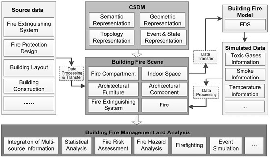
Figure 1.
Architecture underlying the modeling of a building fire scene with the Combinatorial Spatial Data Model (CSDM).
3.2. Semantic Representation of a Building Fire Scene with the Combinatorial Spatial Data Model (CSDM)
With the building fire scene as the root, a semantic tree with multiple nodes was built with the CSDM (Figure 2). The root node can be divided into three child nodes: the fire, fire compartment and fire extinguishing system.
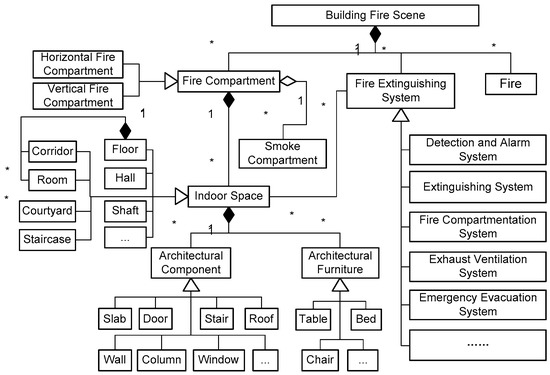
Figure 2.
Semantic representation of a building fire scene with the CSDM.
Fire is the main factor that causes smoke flow and damage to architectural components, and it represents the dominant factor in the formation of a building fire scene. To describe a fire, fire source information (e.g., positions and burning objects), combustion products and reaction parameters must be assigned.
A fire compartment isolates (with respect to the fire) one 3D region of a building from another for a specified (design) period of time. A fire compartment can be divided into horizontal and vertical components, which can control the spread of fire along the horizontal and vertical directions, respectively. The child node of a fire compartment is an indoor space. In addition, the fire compartment also shares this child node with the smoke compartment. Analogous to the fire compartment, the smoke compartment is designed and constructed to prevent the spread of smoke. A fire compartment may have several smoke compartments.
Indoor space is composed of various architectural components, and its spatial form may be a floor, room, corridor, staircase or courtyard [15]. The fire compartment is divided primarily because of the following reasons. (1) An indoor space may exhibit unique features (e.g., a room may have different functions, such as storage, meeting or office space) or specific attributes (e.g., a room number or a different user). Indoor spaces can help decision-makers understand the functions and spatial layout of a building. (2) An indoor space can also serve as the basic unit for building fire simulation and analysis. For example, an indoor space is often used as the basic element for modeling a geometric network of building objects for route analysis.
An architectural component refers to the various elements that compose a building and can include doors, windows, walls and columns, which also represent the basic elements of an architectural space. Various thermophysical parameters (e.g., material and thickness) are fundamental for modeling these components, which provide the basis for building fire simulation and analysis.
The devices of a fire extinguishing system can be categorized into detection and alarm systems, extinguishing systems, fire compartmentation systems, exhaust ventilation systems, and evacuation indication systems, among others [19,20,21]. The main functions of a fire extinguishing system are building fire detection, fire extinguishing, and evacuation indication. The key to modeling a fire extinguishing system is its method of controlling a fire, while descriptions of its spatial attributes (shape and size) are secondary. In other words, the function of a fire extinguishing system is more important than its spatial attributes. In addition, a fire extinguishing system has multiple states, such as opening and closing. As a result of these unique features, modeling a fire extinguishing system is different from modeling an indoor space or an architectural component.
3.3. Geometric Representation of a Building Fire Scene with the CSDM
Vector models and raster models are the two most common techniques used to model building objects in GIS [22]. Combining the requirements of visualization, decision support in building fire management, the geometric representations of building objects can take mixed expressions, that is, vectors, voxels, and grids are all contained in the CSDM, where the voxel and grid data are organized in an object-oriented manner corresponding to each building object.
Vector data form the basis of all other data and are employed to visualize a building fire scene in three dimensions, whereas data models can serve as a boundary representation (B-Rep) [23], body or another type of representation. The 3D building data used in GIS (e.g., *.3ds or *.obj in 3dsMax, *.ive in OpenSceneGraph) or BIM (e.g., *.RVT in AutodeskRevit) can be used as CSDM vector data.
A voxel in the CSDM corresponds to a cuboid in 3D space after vector data voxelization. Voxels are mainly used to represent the body of a building fire scene. The output of a virtual fire simulation can also be stored with voxels. A grid can be defined as a 2.5-dimensional raster cell with a fixed size corresponding to a spatial location, and it can be expressed using semantic information. Such cells are used mainly to describe the movement of a crowd, and they can be regarded as an expanded cellular automata (CA) cell used for crowd simulation [24]. Grid data can be obtained by the postprocessing of voxel data. First, voxels that occupy the same size area in the horizontal direction and are adjacent to each other are merged. Then, the grid represents either the upper- or the under-surface of the merged voxels. A unique identifier of a voxel and grid based on spatial information is defined as follows:
where, the triplet , , represents the center point of the grid and voxel indicating the longitude, latitude, and elevation values (m) respectively, the triplet , , represents the sequence number of the grid or voxel in the X, Y, and Z directions respectively, and the function is used to establish a unique encoding of the grid and voxel. The algorithm used in this paper generates a tuple such as (, , ). To ensure consistency and uniqueness, a globe code was used, that is, the code of the grid or voxel was calculated from the origin of the geographic coordinate system of the building fire scene. , , and can be calculated based on the following equations:
where, , , and represent the X, Y and Z voxel sizes respectively, after voxelization, and represents the value of the integer (round down) conversion calculation.
ID(x,y,z) = f(C,R,Z)
C = ROUNDDOWN(x/Lg,0)
R = ROUNDDOWN(y/Wg,0)
Z = ROUNDDOWN(z/Hg,0)
After encoding, spatially adjacent grids or voxels can be directly calculated via the value. According to the semantic division of a building fire scene, point objects, line objects, surface objects, and body objects can be formed on the basis of the grids and voxels [24]. A point object is a 3D spatial object that consists of a single voxel or grid, and it indicates the geometric information of an independent object (e.g., a sprinkler). A line object is composed of a series of voxels or grid cells, and the maximum value of adjacent grids or voxels is less than 3. A line object can be used to represent an individual motion path. A surface object is a planar geographic entity in a 3D space, and one of the , , or values is the same. A surface object can be used for fire slicing analysis. A body object is the most common spatial object in a building fire scene, an architectural component, such as a door or window, is a body object. Compared with a voxel, a body object with grids is composed of surface objects that indicate the different regions where an individual can move.
3.4. Topological Representation of a Building Fire Scene with the CSDM
Topology is an important method of defining spatial relationships (e.g., adjacency, association, inclusion, and connectivity), and it has been widely used in GIS and BIM [22,25]. Combined with the semantic tree of a building fire scene and taking the semantic features of different nodes as the main logical link, the accessibility between indoor spaces and the association between building fire scene objects is the main consideration of the topological representation in the CSDM, which is characterized by three relationships: containment relationships, association relationships, and adjacency relationships. The following two methods are used to model the topological representation in the CSDM.
(1) Using the semantic tree of a building fire scene, the containment relationships and connectivity relationships between building objects can be described. In addition, the indoor space in which a fire extinguishing system is located is identified in the semantic tree. In this approach, the spatial connectivity between the fire extinguishing system and indoor space can be described.
(2) The NRG is used to describe the adjacency relationships and connectivity relationships among the fire compartment, indoor space, and architectural components. The NRG is a graph (V, E), where V is a set of nodes representing the fire compartment, indoor space or architectural component and E is the set of edges indicating the topological relationship between two nodes [15]. Based on the NRG, the modeling process for topological relationships contains four steps. First, an architectural component is divided to multiple parts along with the indoor spaces it forms. In addition, each part is defined as a new architectural component. Then, the architectural components that form an indoor space are unique. Second, taking architectural component as nodes and the connectivity between nodes as an edge, the NRG with architectural components (named NRG1) is constructed. Third, the floor (node) and ceiling (node) in NRG1 are replaced with the room or another indoor space it forms, the relationships between the related nodes are changed, and a new NRG containing architectural spaces and architectural components (named NRG2) is constructed. Fourth, based on the containment relationships, the indoor space (node) in NRG2 is replaced with the fire compartment to which it belongs, and another new NRG composed of fire compartments and architectural components (named NRG3) is constructed. The NRG used in this paper differs from a road network in GIS: (1) The definitions of nodes and arcs are different. In the CSDM, a node has specific semantics, and an arc represents only the connection relationships among the nodes. In GIS, an arc of a road network is a road segment and the connection points between arcs are defined as nodes. (2) The spatial expression of nodes and arcs are different. In GIS, arcs and nodes of a road network are represented by vector lines and vector points respectively, while nodes in the CSDM are represented with a grid and a voxel. (3) The distance weights of arcs are different. Because the nodes and arcs are modeled with grids and voxels, the distance weight of an arc in CSDM is not a fixed value, it is an interval.
After performing the above steps, three levels of the NRG graph describe the topological relationships (adjacency relationships and connectivity relationships) of a building fire scene, and the architectural components that form the indoor space or fire compartment can also be obtained. According to the fire protection design code of buildings in China (GB 50016-2014), all the outer architectural components of a fire compartment must be fireproof [26]. Therefore, NRG3 can be used to judge whether a fire compartment is fireproof. In addition, referring to IndoorGML, NRG2 can also be used for route analysis, which can provide the basis for a crowd evacuation route and an emergency rescue route calculation. In addition, an implicit topological relationship is observed between grids. A grid can be extended to its neighboring eight grids [24]. Therefore, regarding the grid as a node, the connection relationship between grids is regarded as an edge, and the grids around it in eight directions can be searched from each node. In addition, a grid-based NRG (named NRG4) is formed to facilitate a crowd simulation. The weight of an edge in NRG4 can be set to the geometric distance between two nodes [27].
3.5. Event and State Representation of a Building Fire Scene with the CSDM
In a building fire scene, the event plays a dominant role in the behavioral changes of building objects. A fire event, which is the most important event in a building fire scene, will trigger other events, such as explosions or building collapses. The state is a dynamic attribute of a building object, and its value will change when an event occurs. In other words, building objects have two different types of attributes: invariant attributes and variable attributes. In addition, a variable attribute can be defined by the state.
In reference to the spatial-temporal data GIS model and the characteristics of a building fire scene, an event is defined as follows:
where, represents the identification number of event , represents the type of event , and represent the condition (e.g., time and temperature) and corresponding value respectively, when event occurs, is the attribute information of event , and and represent the building objects related to event and the operation (or the new state) of each building object. Consider an event caused by a fire shutter as an example. A fire shutter may change the topological relationship between two indoor spaces after a fire. in this example is the fire shutter, and represents the topological relationship change in the building fire scene. A sprinkler event may trigger the state of a sprinkler to change from off to on. Here, is the sprinkler, and represents the state (active).
Event(i) = <EID, EType, ECondition, ECValue, EAtrribute, EObjects, OT>
In a building fire scene, the state of a building object is a reflection of its property at a certain moment. The three variable attributes in a building fire scene are as follows: geometric changes (e.g., increasing the dispersal area of combustion products), attribute changes (e.g., the opening or closing of a sprinkler) and topological changes (e.g., changes in the connection relationship within an indoor space after a fire shutter is opened). Based on the architecture used to model a building fire scene with the CSDM (Figure 1), combustion products are reorganized in consideration of the building objects. Thus, by establishing a specific value (e.g., NULL) to indicate that no combustion product exists in this place, the geometrical changes in combustion products can also be expressed as an attribute list. Topological changes affect mainly the connection attribute of an edge in the NRG, and thus, they can also be described by a change in the attribute. Referring to GIS, the state of a building object is defined as follows:
where, represents the identification number of state , and represent the occurrence time and termination time of the state respectively, is the attribute value corresponding to the state, and and represent the previous state and the latter state of , respectively. Based on the neighboring states, all the states of a building object can be quickly traversed, and finally, a state list can be obtained.
State(i) = <SID, SSTime, SETime, SAtrribute, SPState, SNState>
3.6. Unified Modeling Language Class Diagram Graph of the CSDM
Based on a combination of the spatial representations, semantic representations, topological representations, and event and state representations of a building fire scene in the CSDM, a Unified Modeling Language (UML) class diagram graph of the CSDM was designed (Figure 3).
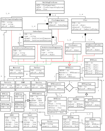
Figure 3.
Unified Modeling Language (UML) class diagram of the CSDM for modeling a building fire scene.
The three main classes of the CSDM are BFSObject, BFSTopology, and BFSEvent, which represent the building object of a building fire scene, the topological representation between building objects, and the event in a building fire scene, respectively.
BFSObject is the most important base class in the CSDM, it includes geometric information (based on BFSGeometry), invariable attribute information, and variable attribute information (based on BFSState). Another six classes (IndoorSpace, ArchitecturalComponent, FireExtinguishingSystem, ArchitecturalFurniture, FireSource and CombustionProduct) are all derived from BFSObject. Based on the spatial representations within the CSDM, BFSGeometry contains three types of information: grids, voxels, and vectors. In addition, point objects (BFSPoint), line objects (BFSLine), surface objects (BFSSurface) and body objects (BFSVolume) can be modeled with the class derived from BFSGeometry. In a building fire simulation, the thermochemical parameters of the architectural components and fire source are very important. For this purpose, five classes, namely, Material, Surface, Particle, RAMP and Species, are defined corresponding to the MATL, SURF, PART, RAMP and SPEC name-list groups respectively, in FDS.
Based on BFSObject, two classes (BFSTContain and BFSTNRG) derived from the BFSTopology class are introduced to describe the inclusion relationship and NRG, respectively. In terms of content expression, BFSTContain class uses a table object (pTable) to describe the contain relationships between building objects. pNode and pEdge, two members of the BFSTNRG class, are used to describe the nodes and edges in the NRG, respectively. pNode will be encapsulated with BFSObject, while pEdge represents the connectivity relationship between two BFSObjects.
The BFSEvnet class includes the type of event (EType), the condition that causes an event (ECondition), the condition value that causes the event (ECValue), the attribute value (EAttribute), and the function to run an event on building objects (runEvent). Under the influence of the events in a building fire scene (BFSEventList), the status information of the building objects and the topology will change. In addition, the changed values will be represented through the BFSState class. The status of each BFSObject includes the start and end time (SSTime and SETime, respectively), the attributes’ information contained in the state, and before and after state information (SPState and SNState).
3.7. Generating the FDS Input File with the CSDM
To obtain the FDS input file, the relationships between the CSDM classes and the FDS name-list groups were initially analyzed (Figure 4), after which the virtual fire scene data were transformed.
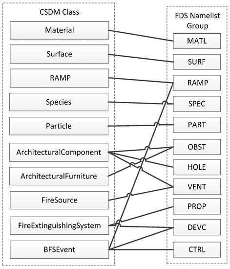
Figure 4.
Relationships between the CSDM classes and the FDS name-list groups.
(1) Traverse the instance objects of the Material, Surface, RAMP, Species, and Particle classes in the building fire scene and generate the MATL, SURF, RAMP, SPEC and PART statements, respectively, of FDS via attribute matching.
(2) Transform the instance objects of ArchitecturalFurniture into the OBST name-list group of FDS. First, compute the corresponding rectangular blocks with the BFSGeometry information of ArchitecturalFurniture. Subsequently, each rectangular block will be written to an OBST name-list group, and the ID properties of these name-list groups will have the same value. Meanwhile, by combining the Surface information with the ArchitecturalFurniture objects, the SURF_ID value of OBST is assigned.
(3) Transform the instance objects of FireSource in the building fire scene into the VENT name-list group of FDS. To obtain the geometry of OBST, the FireSource voxels are merged similar to those of ArchitecturalFurniture. Then, the face corresponding to the vector fire source plane is determined and taken as the geometric information of VENT. Meanwhile, by combining the Surface information with the FireSource, the SURF_ID property of VENT is assigned.
(4) Based on the semantic relationship and the scene parameter settings, transform the instance objects of ArchitecturalComponent in the building fire scene into the OBST, VENT or HOLE name-list groups of FDS. For example, transform walls, ventilation windows and doors in ArchitecturalComponent into OBST, VENT and HOLE, respectively. The transformation process is similar to those described in (2) and (3).
(5) Transform the instance objects of FireExtinguishingSystem in the building fire scene into the DEVC name-list group of FDS. The spatial information of the sprinkler is defined via the BFSPoint class. Thus, the XYZ property of DEVC can be obtained directly. After obtaining the attributes of the FireExtinguishingSystem object, write the PROP name-list group and CRTL name-list group of the FDS. By combining the droplet properties of the sprinkler with the Particle class in this case, the PART_ID property of DEVC is assigned.
(6) Transform the instance objects of BFSEvent in the building fire scene into the DEVC name-list group of FDS. When the event of is TIME, the QUANTITY property of DEVC is set to TIME, and CTRL is assigned based on . The other event transforms are based on their attributes is transformed into the ACTIVATION_TEMPERATURE property of DEVC). Meanwhile, for the of an event for which is TIME, the DEVC_ID property of OBST is assigned. If OBST is associated with multiple events, then the corresponding FDS RAMP name-list group will be written.
(7) Traverse the geometrical information of ArchitecturalComponent and ArchitecturalFurniture in the building fire scene and write a MESH name-list group in the FDS input file for each voxel size. The XB parameter of MESH is the BBOX (bounding box) of BFSObject with same voxel size, and the IJK of MESH is the number of voxels in BBOX.
(8) After performing the above steps, manually add other information, such as the general configuration (e.g., the file name, simulation duration, main gas phase combustion reaction and radiation model) and the output. An FDS input file can finally be obtained.
4. Case Study
A simplified building (12.7 m long, 10 m wide and 3.8 m high) is taken as an example, for which the CSDM is employed to conduct building fire simulation and analysis in this section.
4.1. Case Modeling and Parameter Settings
The spatial environment of the study case is divided into two fire compartments (FC1 and FC2) and four rooms (R1, R2, R3 and R4). In addition, architectural furniture is observed in R3 (Sofa Sf), and a fire extinguishing system (a sprinkler used for discharging water when the effects of a fire have been detected, Sp) is installed (Figure 5). The architectural components of the study case include doors (D1, D2, D3, D4 and D5), walls (from W1 to W14), floors (R1F, R2F, R3F and R4F), and ceilings (R1C, R2C, R3C and R4C). In addition, D2 and D5 are connected to an outdoor space, and D3 is a fire door that can prevent the spread of a fire.
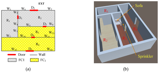
Figure 5.
Spatial environment of the study case: (a) two-dimensional (2D) map and (b) three-dimensional (3D) spatial model.
Combined with the semantic representation of the CSDM, the semantic information of the study case is represented by a tree (Figure 6).
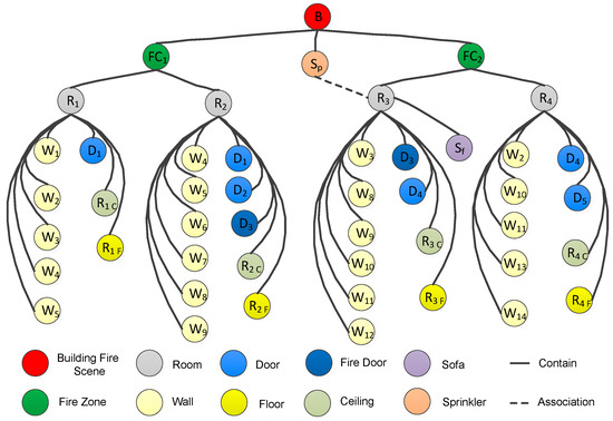
Figure 6.
Semantic tree of the building objects in the study case.
The vector geometry information of the study case was modeled with Autodesk 3dsMax 2010, and the data model used was 3D FACE [28]. Further data processing is needed to transfer the geometric information into the CSDM. For architectural components and architectural furniture, two steps are performed. (1) Voxelization. Based on BINVOX [29] with voxelization on the surface and inside, the vector information is converted into a set of voxels (Figure 7a). The voxelization size in the study case is 0.1 m × 0.1 m × 0.1 m. (2) Merging voxels that occupy the same size area in the horizontal direction and are adjacent to each other in the vertical direction. Either the upper- or the under-surface of the merged voxels constitutes the geometric information of a grid object. For areas inaccessible to individuals (e.g., pillars and walls), the grid information is the upper surface of the merged voxels, whereas the grid geometry information for accessible areas is the undersurface of the merged voxels. For indoor spaces and fire compartments, two other steps are performed. (1) Set a voxel within the indoor space randomly, move along the eight directions to obtain the surrounding voxels, and then judge whether each surrounding voxel belongs to an architectural component one by one. If not, add that voxel to the voxels of the indoor space and extend out further. If yes, stop the extension in this direction until all the voxels are judged (Figure 7b). (2) Obtain the upper surface of the voxels based on the voxels of the indoor space (G1) (Figure 7c). At the same time, project the architectural furniture grid to G1 based on the inclusion relationships between geometric objects (Figure 7d) and store the intersection information in the grid object of the indoor space or fire compartment.
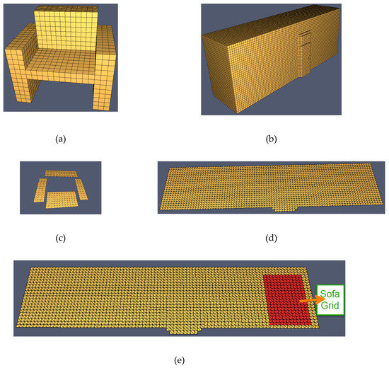
Figure 7.
Geometric information processing for building objects taking a sofa and R3 as examples: (a) the voxels of a sofa, (b) the voxels of R3, (c) the grids of a sofa, (d) the G1 grids of R3, and (e) the intersection between the G1 grids and sofa grids.
Combined with the topological representation of the CSDM, the NRG of the study case was designed (Figure 8).
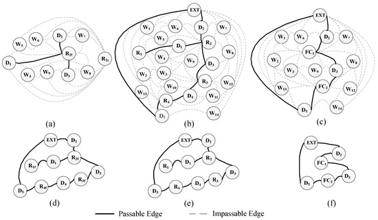
Figure 8.
Topological representation of the study case: (a) Node Relation Graph (NRG) with architectural components (NRG1) taking R2 as an example, (b) NRG with architectural components and architectural spaces (NRG2), (c) NRG with fire compartments and architectural components (NRG3), (d) NRG with architectural components (only passable edges are retained), (e) only the passable edges of NRG2 are retained, and (f) only the passable edges of NRG3 are retained.
Combined with related studies, the materials of the building objects and their thermochemical parameters are established (Table 1 and Table 2) [30].

Table 1.
Materials used in the study case.
Table 2.
Main parameters of the materials of the building objects in the study case.
The virtual fire scene is designed as follows. (1) Initially, all doors are open. (2) After 60 s, a fire occurs. The fire source is on the sofa seat (the size is 0.6 m × 1.0 m), the heat release rate per unit area is 1000.0 kW/m2, and the release of heat is sustained, the reaction of fire is defined as in Table 3. (3) At 30 s after the fire breaks out, D3 is closed. In addition, the two fire compartments are isolated by the fire door. (4) When the temperature exceeds 74 °C, a spraying operation is triggered, discharging water. Combined with the scene settings above, the state types and events are defined (Table 4 and Table 5).
Table 3.
The main reaction parameter of the building fire.
Table 4.
State types of the building objects in the study case.
Table 5.
Events of the study case.
4.2. Building Fire Simulation in the Study Case
The cell size of building fire simulation in this case is 0.1 m × 0.1 m × 0.1 m. For the vector data used in the study case was 3dsMax, to obtain the geometry of OBST, the voxels of ArchitecturalFurniture or ArchitecturalComponent are merged as follows: take the length, width and height of a voxel as the step size, where the shape of a merged voxel must be a rectangular block as a constraint condition. The voxels are merged along the X, Y and Z directions in turn until all are traversed (Figure 9). After the FDS input file was obtained, the building fire simulation can be conducted by launching the FDS (Figure 10a), and the fire dynamic process can be visualized with SmokeView [31] (Figure 10b).
Figure 9.
OBST name-list groups of the sofa in the study case, where each cuboid is a name-list group.
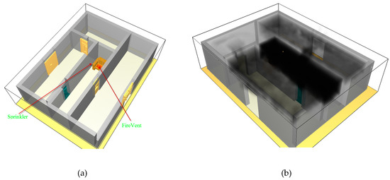
Figure 10.
Building fire simulation in the study case: (a) building fire scene in the FDS and (b) building fire simulation at time = 91 s.
Plot3D is an important file format of the FDS output data that is also used by many computational fluid dynamics (CFD) programs to represent simulation results [32]. The spatial unit of Plot3D data is a voxel. Thus, by spatially matching the contained voxels between Plot3D and the building objects in the building fire scene, Plot3D fire data can be extracted and reorganized relative to the corresponding building objects.
4.3. Building Fire Analysis in the Study Case
Taking Unity3D as the 3D render engine [33], a prototype system was developed to support the building fire analysis. The main functions of this system are to first load various data, integrate them with the CSDM to model a building fire scene, and provide building fire management support, such as associated queries among BFSObjects, spatiotemporal statistical analysis, route analysis, fire assessment and visualization (including spatial scene visualization and fire dynamic visualization).
Taking D3 as an example, the associated query among BFSObjects is shown in Figure 11. In this example, the information (e.g., AID and Type) of D3 can be obtained directly through the ArchitecturalComponent object, adjacent nodes and parent nodes can be calculated on the topological representation of the CSDM, surface and material information can be calculated through the associated ID, and the visibility and temperature can be obtained through combustion product matching.
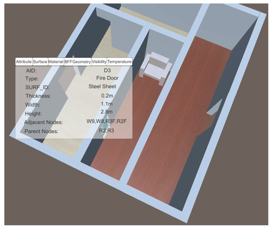
Figure 11.
Example of an associated query taking D3 as an example.
Taking Sp and the rooms in the study case as an example, the spatiotemporal statistical analysis is shown in Figure 12. Figure 12a shows the following: (1) due to the impact of the fire, the temperatures of all five voxels rapidly increased, and four voxels tended to stabilize after 110 s, and (2) the temperature variations of voxel (x, y − 1, z − 1) and voxel (x, y + 1, z − 1) are relatively large, which may have been caused by the proximity of the walls (W9 and W10, respectively). The average visibility of a room at time in Figure 12b is defined as follows:
where, is the count of voxels in the room and is the visibility of voxel at time . Figure 12b shows the following: (1) due to the fire, the average visibility in the four rooms decreased at different degrees, and the average visibility in the room where the fire occurred (R3) decreased significantly earlier than those in the other rooms, (2) the rates of decrease and the declines in the R3 values are also the largest compared with those in the other rooms, and (3) in the initial stage of the fire, R4 has a better visibility than R2 due to the relatively high amount of smoke entering R2. Due to the closing of the fire door (time = 90 s), the rate of the average visibility decrease in R2 decelerates gradually. After the time reaches 104 s, the visibility in R4 is worse than that in R2.
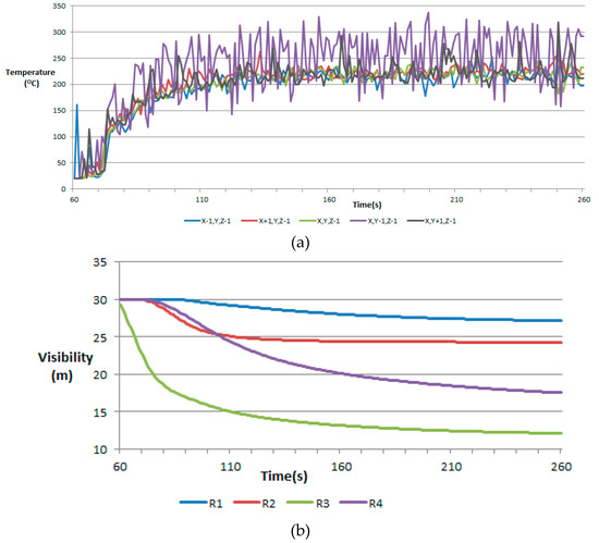
Figure 12.
Example of spatiotemporal statistical analysis: (a) temperature profiles of the five voxels below Sp, where the spatial coordinate of Sp is defined as (x,y,z), and Sp was activated at 84.1 s, (b) average visibility profiles of the rooms.
A route analysis under different scenes was also performed (Figure 13) with NRG2 and NRG4. Before the fire, the route for a person at a given starting point to leave the building can be calculated on the condition that the moving distance is the shortest (Figure 13a). The corresponding routing algorithm has four steps. First, calculate the grid (Gs) and the corresponding BFSObject object (BFO1) where the starting point is located. Second, search the BFSObject objects (BFOes) for the types that are exits. Third, obtain the shortest distance route from BFOs to each object of BFOes based on NRG2 and the route search algorithm (e.g., Dijkstra or A*) [34], and then obtain a list of BFSObject objects, such as BFO1, BFO2,…, BFOm. Fourth, with the objects obtained in the third step, the routing algorithm in NRG4 can be decomposed into an m + 1 subpath search: Gs to BFO1, BFO1 to BFO2,…, BFOm−1 to BFOm. The shortest path from Gs is the sum of all the subpath searches, and the geo-location of the path can be expressed as a series of grids. After a fire, the hazards of the fire to the building and the crowd can be used as additional constraint conditions instead of the distance to obtain the corresponding route. Figure 13b describes the route from the same given starting point in Figure 13a to leave the building after a fire (60 s < time < 90 s) with the condition that the room being passed through has the maximum average visibility. For the condition where D3 is open in Figure 13b, R4 and D5 are selected in NRG2 because R4 has a better average visibility than R2.
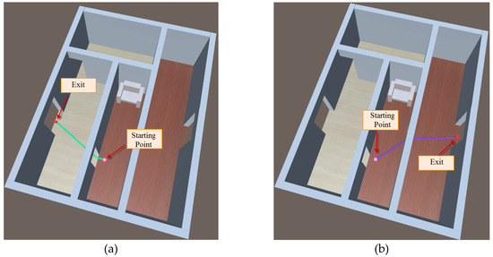
Figure 13.
Route analysis under different scenes: (a) before the fire, the path was obtained with the minimum distance and (b) after the fire (60 s < time < 90 s), the path was obtained through the maximum average visibility of a passed room.
Simulating the crowd is an important component of fire assessment [18]. In reference to previous research [24], a crowd simulation is conducted for the study case (Figure 14). The initial positions of the individuals in the study case were set randomly at the location of either D2 or D5. In addition, the behavior of individuals before the fire was set from one exit to another exit. At the grids, individual accessibility was non-architectural furniture projection grids. Three scenes were simulated in the study case. (1) Scene 1 (Figure 14a), which represents either the time before a fire or when an individual does not perceive the fire (time < = 80 s). With the grid of an individual located, the shortest distance is the condition, and the BFSObject objects that an individual can cross are searched based on NRG2. Then, based on the social force model, the grids through which an individual passes in each BFSObject object are searched. (2) Scene 2 (Figure 14b), in which the fire was sensed by individuals at time = 89 s, and the schedule changes accordingly. Individuals in the fire room (R3) will move to the door farthest from the fire and then move to the building exit. Individuals in other rooms will choose the path with the shortest distance to the building exit. (3) Scene 3 (Figure 14c), in which the fire door (D3) is closed at time > = 90 s, and NRG2 is changed. Individuals in the fire room (R3) may still choose another path to the building exit. The routes of certain individuals in Scene 2 will be recalculated, and the directions of movement of the individuals will also change.
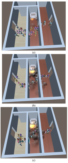
Figure 14.
Crowd simulation conducted in the study case: (a) individual moves to another exit from one exit, (b) individual selects its route based on the room in which it is located, and (c) the fire door (D3) is closed, as a result of which the movement directions of some individuals may change.
5. Discussion and Conclusions
Applications such as emergency response, indoor navigation, and facility management have made the 3D indoor spatial environment more important than in the past [15,35]. For building fire simulation and analysis, developing a smart spatial data model that supports building fire simulation and analysis is also important. Take building fire as an example, the methods of modeling the fire scene in 3D indoor spatial environment was advanced and described in this paper, which provide a basis for the integration of GIS and building fire. And with CSDM, a smarter analysis for building fire management can be designed and conducted with GIS in the succeeding work.
The advantages of modeling a building fire scene with CSDM are: (1) a unified spatial-temporal framework for a building fire scene that incorporates all information related to a building fire process can be provide, (2) a multiple-level implementation of building fire analysis (i.e., voxel, grid or object in a spatial dimension, architectural component, indoor space or fire compartment in a sematic dimension) can be conducted, and (3) a variety of applications analysis (e.g., fire hazard assessment and crowd simulation) can be support also.
The case study is conducted with 3dsMax data in this paper. To conduct a case study with BIM data, a data mapping between CSDM and IFC must be designed further. (1) In the IFC, the indoor space is defined with IfcSpace and IfcBuildingStorey, and the architecture component is defined with IfcBuildingElement. To get the BFSObject information of CSDM, the semantic relationships between the CSDM and the IFC must be designed first. (2) The geometric information of the IFC is defined with IfcRepresentation, and can be expressed with wireframe, surface or solid. To get the Voxel and Grid information of each BFSObject, geometric data transform is not dispensable and can be conducted with voxelization and grid data processing, the same as with 3dsMax data. (3) The IFC contains rich spatial relationships between building objects, which is defined with IfcRelAggregates and IfcRelContains. With information extraction, the containment relationships, connectivity relationships, adjacency relationships and connectivity relationships between building objects can be obtained [36,37]. After that, the corresponding topological information of the CSDM (BFSTContain and BFSTNRG) can be subsequently set.
Although the model architecture and the approach to modeling a building fire scene with the CSDM are given in detail, a number of different aspects should be further researched. First, the study case in this paper is relatively simple, whereas real-world buildings are much more complex. A combination of the CSDM with a more complex building study case and additional building fire analyses therefore require further research. In particular, more design efforts are needed for building fire analysis with GIS. Second, although the FDS is widely used, simulating a building fire with the FDS can result in long computational times when a fine MESH size is used and/or a large domain is specified [4], thus, it is difficult to meet the needs of rapid emergency decision making. Therefore, it is necessary to extend the CSDM model and integrate it with other building fire models in addition to the FDS. Third, the integration of CSDM with IFC, IndoorGML, or CityGML needs further research also.
Author Contributions
Yiquan Song contributed paper writing and method implementation. Lei Niu and Yi Li contributed ideas of the paper and the case study.
Funding
This research was funded by the National Natural Science Foundation of China (Nos. 41571387, 41771433, 41871323, and 41501440), and the National Science Foundation of Tianjin (No. 18JCYBJC90600).
Conflicts of Interest
The authors declare no conflict of interest.
References
- Kobes, M.; Helsloot, I.; De Vries, B.; Post, J.G. Building safety and human behaviour in fire: A literature review. Fire Saf. J. 2010, 45, 1–11. [Google Scholar] [CrossRef]
- Xin, J.; Huang, C. Fire risk analysis of residential buildings based on scenario clusters and its application in fire risk management. Fire Saf. J. 2013, 62, 72–78. [Google Scholar] [CrossRef]
- Walton, W.D.; Carpenter, D.J.; Wood, C.B. Zone computer fire models for enclosures. In SFPE Handbook of Fire Protection Engineering; Springer: Berlin/Heidelberg, Germany, 2016; pp. 1024–1033. [Google Scholar]
- McGrattan, K.; Hostikka, S.; McDermott, R.; Floyd, J.; Vanella, M. Fire Dynamics Simulator, Technical Reference Guide; NIST: National Institute of Standards and Technology: Gaithersburg, MD, USA, 2019. [Google Scholar]
- Lin, C.-C.; Wang, L.L. Real-time forecasting of building fire growth and smoke transport via ensemble kalman filter. Fire Technol. 2017, 53, 1101–1121. [Google Scholar] [CrossRef]
- Yung, D. Principles of Fire Risk Assessment in Buildings; John Wiley & Sons: Hoboken, NJ, USA, 2008. [Google Scholar]
- Wu, C.-H.; Chen, L.-C. 3D spatial information for fire-fighting search and rescue route analysis within buildings. Fire Saf. J. 2012, 48, 21–29. [Google Scholar] [CrossRef]
- Cha, M.; Han, S.; Lee, J.; Choi, B. A virtual reality based fire training simulator integrated with fire dynamics data. Fire Saf. J. 2012, 50, 12–24. [Google Scholar] [CrossRef]
- Rüppel, U.; Schatz, K. Designing a bim-based serious game for fire safety evacuation simulations. Adv. Eng. Inform. 2011, 25, 600–611. [Google Scholar] [CrossRef]
- Xu, Z.; Lu, X.; Guan, H.; Chen, C.; Ren, A. A virtual reality based fire training simulator with smoke hazard assessment capacity. Adv. Eng. Softw. 2014, 68, 1–8. [Google Scholar] [CrossRef]
- Tang, F.; Ren, A. Gis-based 3d evacuation simulation for indoor fire. Build. Environ. 2012, 49, 193–202. [Google Scholar] [CrossRef]
- Dimyadi, J.; Spearpoint, M.; Amor, R. Sharing building information using the ifc data model for fds fire simulation. Fire Saf. Sci. 2008, 9, 1329–1340. [Google Scholar] [CrossRef]
- Azhar, S. Building information modeling (BIM): Trends, benefits, risks, and challenges for the AEC industry. Leadersh. Manag. Eng. 2011, 11, 241–252. [Google Scholar] [CrossRef]
- Gröger, G. Opengis City Geography Markup Language (CityGML) Encoding Standard; Open Geospatial Consortium: Wayland, MA, USA, 2008. [Google Scholar]
- Li, K.J.; Lee, J.Y. Basic concepts of indoor spatial information candidate standard indoorgml and its applications. J. Korea Spat. Inf. Soc. 2013, 21, 1–10. [Google Scholar]
- Chen, L.-C.; Wu, C.-H.; Shen, T.-S.; Chou, C.-C. The application of geometric network models and building information models in geospatial environments for fire-fighting simulations. Comput. Environ. Urban Syst. 2014, 45, 1–12. [Google Scholar] [CrossRef]
- Tashakkori, H.; Rajabifard, A.; Kalantari, M. A new 3d indoor/outdoor spatial model for indoor emergency response facilitation. Build. Environ. 2015, 89, 170–182. [Google Scholar] [CrossRef]
- Ronchi, E.; Alvear, D.; Berloco, N.; Capote, J.; Colonna, P.; Cuesta, A. Human behaviour in road tunnel fires: Comparison between egress models (fds+ evac, steps, pathfinder). In Proceedings of the Twelfth International Interflam 2010 Conference, Nottingham, UK, 5–7 July 2010; pp. 837–848. [Google Scholar]
- Mobin, M.I.; Abid-Ar-Rafi, M.; Islam, M.N.; Hasan, M.R. An intelligent fire detection and mitigation system safe from fire (sff). Int. J. Comput. Appl. 2016, 133, 1–7. [Google Scholar]
- Alshbatat, A.I.N. Fire extinguishing system for high-rise buildings and rugged mountainous terrains utilizing quadrotor unmanned aerial vehicle. Int. J. Image Graph. Signal Process. 2018, 10, 23–29. [Google Scholar] [CrossRef]
- Ye, X.; Ma, J.; Shen, Y.-X.; Lin, L.-Y. Suppression effect of sprinkler system on fire spread in large commercial buildings. Procedia Eng. 2016, 135, 455–462. [Google Scholar] [CrossRef][Green Version]
- Bonham-Carter, G.F. Geographic Information Systems for Geoscientists: Modelling with Gis; Elsevier: Amsterdam, The Netherlands, 2014; Volume 13. [Google Scholar]
- Varady, T.; Martin, R.R.; Cox, J. Reverse engineering of geometric models—An introduction. Comput.-Aided Des. 1997, 29, 255–268. [Google Scholar] [CrossRef]
- Song, Y.; Gong, J.; Niu, L.; Li, Y.; Jiang, Y.; Zhang, W.; Cui, T. A grid-based spatial data model for the simulation and analysis of individual behaviours in micro-spatial environments. Simul. Model. Pract. Theory 2013, 38, 58–68. [Google Scholar] [CrossRef]
- Daum, S.; Borrmann, A. Processing of topological bim queries using boundary representation based methods. Adv. Eng. Inform. 2014, 28, 272–286. [Google Scholar] [CrossRef]
- The Ministry of Public Security of PR China. Code for Fire Protection Design of Buildings (GB 50016-2014); Ministry of Housing and Urban-Rural Development of the People’s Republic of China: Beijing, China, 2014. [Google Scholar]
- Song, Y.-Q.; Niu, L.; He, L.; Wang, R. A grid-based graph data model for pedestrian route analysis in a micro-spatial environment. Int. J. Autom. Comput. 2016, 13, 296–304. [Google Scholar] [CrossRef]
- McHenry, K.; Bajcsy, P. An overview of 3d data content, file formats and viewers. Natl. Cent. Supercomput. Appl. 2008, 1205, 22. [Google Scholar]
- Patrick, M. Binvox: 3D Mesh Voxelizer. 2004. Available online: https://www.patrickmin.com/binvox (accessed on 24 April 2019).
- Hurley, M.J.; Gottuk, D.T.; Hall, J.R., Jr.; Harada, K.; Kuligowski, E.D.; Puchovsky, M.; Watts, J.M., Jr.; Wieczorek, C.J. SFPE Handbook of Fire Protection Engineering; Springer: Berlin/Heidelberg, Germany, 2015. [Google Scholar]
- Mainetti, L.; Patrono, L.; Sergi, I. A Survey on Indoor Positioning Systems. In Proceedings of the 2014 22nd International Conference on Software, Telecommunications and Computer Networks (SoftCOM), Split, Croatia, 17–19 September 2014; IEEE: Piscataway, NJ, USA, 2014; pp. 111–120. [Google Scholar]
- Soetaert, K. Plot3d: Plotting Multi-Dimensional Data. 2013. Available online: https://rdrr.io/cran/plot3D (accessed on 24 April 2019).
- Creighton, R.H. Unity 3D Game Development by Example: A Seat-of-Your-Pants Manual for Building Fun, Groovy LITTLE Games Quickly; Packt Publishing Ltd.: Birmingham, UK, 2010. [Google Scholar]
- Delling, D.; Sanders, P.; Schultes, D.; Wagner, D. Engineering route planning algorithms. In Algorithmics of Large and Complex Networks; Springer: Berlin/Heidelberg, Germany, 2009; pp. 117–139. [Google Scholar]
- Li, K.-J. Indoor space: A new notion of space. In Proceedings of the International Symposium on Web and Wireless Geographical Information Systems, Shanghai, China, 11–12 December 2008; Springer: Berlin/Heidelberg, Germany, 2008; pp. 1–3. [Google Scholar]
- Pang, Y.; Zhang, C.; Zhou, L.; Lin, B.; Lv, G. Extracting indoor space information in complex building environments. ISPRS Int. J. Geo-Inf. 2018, 7, 321. [Google Scholar] [CrossRef]
- Khalili, A.; Chua, D.H. Ifc-based graph data model for topological queries on building elements. J. Comput. Civ. Eng. 2013, 29, 04014046. [Google Scholar] [CrossRef]


© 2019 by the authors. Licensee MDPI, Basel, Switzerland. This article is an open access article distributed under the terms and conditions of the Creative Commons Attribution (CC BY) license (http://creativecommons.org/licenses/by/4.0/).