Article

Characterizing the Water Balance of the Sooke Reservoir, British Columbia over the Last Century

by
Arelia T. Werner
1,*,
Terry D. Prowse
2,† and
Barrie R. Bonsal
3,†
1
Pacific Climate Impacts Consortium, University of Victoria, Victoria, BC V8P 5C2, Canada
2
Water and Climate Impacts Research Centre, Department of Geography, Environment Canada at the University of Victoria, Victoria, British Columbia, V8W 3R4, Canada
3
Environment Canada, 11 Innovation Boulevard, Saskatoon, Saskatchewan, S7N 3H5, Canada
*
Author to whom correspondence should be addressed.
These authors contributed equally to this work.
Climate 2015, 3(1), 241-263; https://doi.org/10.3390/cli3010241
Submission received: 8 October 2014 / Revised: 3 February 2015 / Accepted: 27 February 2015 / Published: 13 March 2015
(This article belongs to the Special Issue Changes in Precipitation and Impacts on Regional Water Resources)

Abstract

:
Infrastructure such as dams and reservoirs are critical water-supply features in several regions of the world. However, ongoing population growth, increased demand and climate variability/change necessitate the better understanding of these systems, particularly in terms of their long-term trends. The Sooke Reservoir (SR) of British Columbia, Canada is one such reservoir that currently supplies water to ~300,000 people, and is subject to considerable inter and intra-annual climatic variations. The main objectives of this study are to better understand the characteristics of the SR through an in-depth assessment of the contemporary water balance when the basin was intensively monitored (1996–2005), to use standardized runoff to select the best timescale to compute the Standard Precipitation (SPI) and Standard Precipitation Evaporation Indices (SPEI) to estimate trends in water availability over 1919 to 2005. Estimates of runoff and evaporation were validated by comparing simulated change in storage, computed by adding inputs and subtracting outputs from the known water levels by month, to observed change in storage. Water balance closure was within ±11% of the monthly change in storage on average when excluding months with spill pre-2002. The highest evaporation, dry season (1998) and lowest precipitation, wet season (2000/2001) from the intensively monitored period were used to construct a worst-case scenario to determine the resilience of the SR to drought. Under such conditions, the SR could support Greater Victoria until the start of the third wet season. The SPEI and SPI computed on a three-month timescale had the highest correlation with the standardized runoff, R2 equaled 0.93 and 0.90, respectively. A trend toward drier conditions was shown by SPEI over 1919 to 2005, while moistening over the same period was shown by SPI, although trends were small in magnitude. This study contributes a validated application of SPI and SPEI, giving more credit to their trends and estimated changes in drought.

Graphical Abstract

1. Introduction

To provide a more dependable supply, water is retained via dams and reservoirs. Climate change/variability and rising population are increasing pressure on reservoirs [1], with the former being associated with higher temperatures and intensification of the hydrologic cycle. The frequency and magnitude of extremes events, such as floods and droughts has also increased in some areas with historical climate change [2]. These changes are projected to continue into the future with or without mitigation [3]. Thus, understanding the role of climate change/variability on water supply is part of best management practices for reservoirs.
The water balance is a full account of all of the inputs and outputs from a lake or reservoir [4]. In different regimes and regions predominant terms vary. For example, in one system losses from evaporation may exceed that from consumption while in another, these roles are reversed. To understand the resiliency of a system to climate change one must evaluate the effect of temperature and precipitation changes acting on each component of the water balance [5]. These changes will predict the future water availability of a reservoir. Unfortunately, lack of available data often limits full evaluations because few systems have been adequately monitored and even fewer have long term records required for the proper assessment of trends and variability.
The Sooke Reservoir (SR) is the main water supply for Victoria, British Columbia, Canada. It provides storage and therefore consistent water availability in a region with strong seasonal contrasts characteristic of its Mediterranean-type climate (wet winters and pronounced dry summers). It has been in existence for nearly 100 years and precipitation, temperature and water-levels have been monitored over this time. Furthermore, since 1996, streamflow, water temperature and additional climatic data have been collected for the SR and its watershed has been protected from land-use practices, such as logging. The combination of a near-term intensively monitored period (1996–2005) and a long-term climate record (1919–2005) makes the SR an ideal setting to study the relationship between climate change and long-term water balance. Additionally, severe moisture surpluses and deficits have occurred in the recent record. For example, during one drought in 2000/2001, low water levels forced the Capital Regional District (CRD) to put their most severe water restrictions (Stage 3) into place for the first time [6,7,8]. This event prompted interest in the future impacts of climate change/variability in this region and put into question the resiliency of the SR in the face of future changes. It also sparked an inquest into how severe this drought was verses others historically and how to estimate water availability based on temperature and precipitation records.
A few methods have been developed to estimate the water availability or drought where monitoring has been insufficient to characterize all terms. These include indices commonly used in drought management that rely on temperature and/or precipitation data to estimate moisture surplus and deficits. The Palmer Drought Severity Index (PDSI) and Standardized Precipitation Index (SPI) are the two most commonly used indices [9]. The PDSI is calibrated to local soil conditions making cross comparison with other climate zones challenging and has a fixed time scale (between 9 and 12 months). The SPI is based only on precipitation and thus does not reflect temperature-induced changes, such as evaporation. The Standardized Precipitation-Evapotranspiration Index (SPEI) was developed in 2010 to combine the sensitivity of the PDSI to evaporation demand with the simplicity of calculation and multi-temporal nature of the SPI [10]. Its application in climatic and hydrologic studies has grown rapidly. Recently, its authors have provided refinements and guidelines to support flexible and robust use of the SPEI [11].
The direction of historical trends in water availability or drought is a contentious field of research [2,12,13]. In the region of the SR, annual precipitation has increased slightly, with the greatest increases (10% to 20%) occurring in summer over the 20th Century [14]. Over the same time mean annual temperatures have increased, minimum annual temperatures have increased more than maximums and warming has occurred in all seasons except summer maximums. Thus, trends in water availability in the SR strike a balance between losses from evaporation due to warming temperatures and inputs from increased precipitation. Furthermore, in the Mediterranean climate setting of the SR, trends in temperature and precipitation are opposite those in the surrounding province of British Columbia and state of Washington in some seasons. Therefore, the SR provides a unique setting where one can validate the implementation of the SPI and SPEI by using a fully characterized short-term water balance to identify the time scale (1, 3, 6, 12, 24 and 48 months) these indices should be applied. This approach will help to avoid inflated trends in the SPI and SPEI [11].
The objectives of this study are to: (1) fully characterize the water balance of the SR over 1996–2005 when the basin was intensively monitored; (2) select the best time scale to compute the Standard Precipitation Index (SPI) and the Standard Precipitation Evaporation Index (SPEI) indices; and (3) analyze changes in the long-term (~100 years) water availability using these indices. This will provide a better understanding of the resiliency of the SR to climate change/variability in a Mediterranean-type climate and add a locally validated trend in drought to the global evaluation.

2. Study Site

The SR drainage basin (Figure 1) is located at 48°30′N latitude and 123°42′W longitude. Covering an area of 70 km2 (including the 7 km2 SR), it represents about 91% of the Greater Victoria Water Supply [15]. Water is diverted from the Council Creek watershed to supplement the Sooke Reservoir Catchment (SRC) supply, which adds 10 km2 of drainage area when in use [16]. From late spring through early fall, inflows diminish while water consumption increases causing the SR water level to decline until the rains arrive in late fall [17].
The 30-year normal period of 1971–2000, developed using the long-term data collected at the SR dam, show annual average air temperatures ranged from a minimum of 7.9 °C in 1985 to a maximum of 10.2 °C in 1998 and were 8.8 °C on average. Total annual precipitation varied from a minimum of 731 mm in 1985 to a maximum of 2317 mm in 1990 and averaged 1640 mm. Maximum monthly precipitation occurs in November (301 mm) and minimum in July (29 mm), which is typical for a northern Mediterranean-type climate. Mean monthly temperatures are at their minimum in January (2.3 °C) and maximum temperatures are reached in July and August (16.4 °C and 16.5 °C, respectively).
The current reservoir is oligotrophic and monomictic [18] with a surface area to overall catchment ratio of 1:10. The lake is 6.0 km long and 1.5 km wide at its widest point. The lake volume was increased in 2002 when it was raised 6 m to a height of 186.75 metres above sea level (masl), increasing the holding capacity by 78% (92.7 × 10⁶ m3 from 52.0 × 10⁶ m3). The SR has a maximum surface area of 7.35 × 10⁶ m2 and three main basins, which have a surface area ratio of 10:3:1, respectively, decreasing in size from north to south [19]. Minimum water temperatures reach 4 °C for most years, but have been recorded as low as 3 °C. In late summer, maximum surface water temperatures reach as high as 28 °C.
Figure 1. Sooke Reservoir study area.
Climate 03 00241 g001

3. Methods and Data

The water balance of the SR is defined as:
P + R E   O C   O S   O F   ±   Δ ε =   Δ S
where P is precipitation, R is runoff, E is evaporation, OC is consumption, OS is spill, OF is fisheries release, ΔS is change in storage, and Δɛ is the error accumulated from each term (all presented in m3·month−1). Note that Kenney [20] determined that most of the materials in the SR area had groundwater flow rates on the order of 102–103 m3·month−1. These amounts likely fit within the error for the overall budget considering average consumption is ~8 × 10⁶ m3·month−1 and minimum evaporation cannot be much less than ~1 × 10⁴ m3·month−1 given the SR’s ~7 × 10⁶ m2 surface area. As a check, monthly flow rates in Rithet Creek when Judge Creek has no discharge will be used as a first order approximation of groundwater flow rates. Results will be discussed in Section 4.1.5 (Closure of the Contemporary Water Balance).
Each term in the SR’s water balance has been evaluated to varying degrees over its more than 100-year operation (Table 1). Precipitation has been measured since 1903 and temperature since 1919, except for 1966–1995, when temperature was infilled with a regression to the Shawnigan Lake met station, which is just northeast of the SR management boundary (Figure 1). Monitoring of runoff from the two main contributors to the basin (42% of the drainage area) started in the 1990s along with observations of a diversion from the neighboring Council Creek watershed. The monitoring of all variables required for evaporation estimation (minimum and maximum air temperature, water temperature, wind speed and direction and shortwave radiation) only became available in the 1990s. From October 1996 to September 2005, monitoring was at its maximum both spatially and temporally. The contemporary water balance is computed over this 9-year period of intensive monitoring.
Table 1. Meta-data for measurements made in the Sooke Reservoir by the Capital Regional District (CRD).
VariableStart YearsEnd YearsTime StepLocationsMeasurement Method
Min/Max Air Temperature19191966DailyNear Sooke DamManual Gauge
1995PresentHourlyBelow Sooke DamAutomatic Gauge
Precipitation19031970DailyNear Sooke DamManual Gauge
19711998DailyOn Sooke DamManual Gauge
1995PresentHourlyBelow Sooke DamAutomatic Gauge
Wind Speed/Direction1995PresentHourlyOn Intake TowerAnemometer
Shortwave Radiation1998PresentHourlyOn Intake TowerPyranometer (PYR) Photometric (PAR)
Reservoir Water Level19191998DailyNear Intake TowerManual
December 1998PresentHourlyNear Intake TowerAutomatic
Consumption19191970DailyOutletWeir
19701992DailyOutletMechanical Meter
19922002DailyOutletVenturi Meter
2002PresentMinuteOutletMagnetic Flow Meter
Spill19701998DailyManual gates on damWater Level
Dec 19982002HourlyManual gates on dam Gravity-free crest spillwayWater Level
2002PresentHourly Water Level
Fisheries ReleaseFeb 2004PresentHourlyDeception Reservoir SpillwayMagnetic Flow Meter
Runoff1993PresentHourlyRithet Creek (18 km2)Rithet–flume
Judge Creek (9 km2)Judge–V-notch weir
Council Creek Diversion1992PresentSub-DailyCouncil CreekV-notch weir
Water Temperatures1996PresentSub-MonthlyFour locations in reservoir at multiple depthsSea-bird temperature profiler
For the contemporary water balance (Equation (1)), precipitation over the surface of the SR is well approximated by the gauge at Sooke Dam [21]. Outflows from consumption, spill and fisheries release and change in storage are measured by the CRD (Table 1). Runoff from 58% of the catchment area is undefined and evaporation is estimated on an annual time step [18]. Therefore, runoff and evaporation were not fully characterized on a monthly time step. Their estimation is a focus of this study.

3.1. Modelled Components of the Contemporary Water Balance (1996–2005)

3.1.1. Runoff

Two methods of estimating surface water inflows to the SR are compared. In the first, a hydrologic model is applied to portions of the watershed that have been monitored continuously or by spot measurements (68%) and these volumes are scaled up to represent the unmodelled catchments that have similar physical characteristics (Table 2). The widely applied Hydrologiska Byråns Vattenbalansavdelning (HBV) hydrologic model [22,23,24] a semi-distributed, deterministic model with a classification of land use (forest, open or lake) by elevation [22] is used. Similar catchments are identified based on slope, aspect, and land cover types defined in the 2001 Compartment Analysis of the Sooke water-supply area [6]. In the second method, the contributing-area approach is applied where the relationship between the runoff from 42% of the basin that was monitored continuously from 1996 to 2005 (Rithet and Judge Creeks) and those basins that had been continuously monitored for 13 months from 2004 to 2005 (Whiskey, Maple and Horton Creeks) are used to estimate the runoff from the unmonitored portions of the basin (58%). Again, runoff from the monitored portion is converted to total runoff based on multiplying by areas with similar physical characteristics.
Table 2. Areas as modelled by HBV and their respective representative areas.
CatchmentModelled Area (km2)Representative Area (km2)Percent Modelled Area of Representative Area (%)Percent Representative Area of Total Catchment Area (%)
Rithet18199231
Judge9127219
Horton284812
17S2
Magee16459
Coquihalla2
Jones2103015
3.5 km2
Whiskey476311
Maple12563
Total436365100
HBV was calibrated to the Rithet basin (NASH 0.79, MVE 10%) and validated in the Judge basin (NASH 0.78, MVE 10%) over the period of intensive monitoring [25]. Thus, the model simulates discharge for these two catchments well. However, inflows from the contributing area approach were consistently greater than those estimated with the modelling approach, for both peak and low-flow events, although the two estimates had similar timing (Figure 2). Two factors contributed to this. Firstly, the model performed sub-optimally at simulating the magnitude of the peaks because of compromises made for better calibration results over the whole year. This effect was then multiplied across the basin. The second is that the low-flows are less in the HBV model because of differences in the way the two methods assess flows from Maple Creek. Estimates from the contributing-area approach were applied in the short-term water balance because they better captured peak-flow events that contribute a substantial portion of inputs in the wet season.

3.1.2. Evaporation

There are several methods for estimating open-water evaporation that range in complexity and data requirements. The Penman [26] approach is one example of a complex and data intensive method. It is used to estimate evaporation in this study because all required input variables are available and the method has been shown to produce realistic results under a variety of different hydro-climatic zones [27,28]. The Penman [26,29] estimate of evaporation (mm d−1) from open water is described in Shuttleworth [30] as:
E P =   s s +   γ   ×   ( R n   Q H S ) λ +   γ s +   γ   ×   6.43 ( f u ) D λ
where EP is potential open water evaporation or evapo-transpiration; Rn is net radiation at the surface (MJ·m−2∙d−1) estimated using measured incoming shortwave radiation and estimated longwave radiation based on measured air temperature and the Stefan-Boltzman constant; QHS is the heat flux into the lake (MJ·m−2∙d−1); s is the slope of the saturation vapour pressure curve (kPa·°C−1); γ is the psychrometric coefficient (kPa·°C−1); λ is the latent heat of vaporization (MJ·kg−1); fu is the wind function (m·s−1); and D = (esea) is the vapour pressure deficit (kPa) where es is saturation vapour pressure (kPa) and ea is actual vapour pressure (kPa).
Figure 2. A Comparison of inflow estimates from the HBV model and the Contributing Area Approach (m3·d−1).
Climate 03 00241 g002
The mean change of reservoir heat storage QHS (MJ·m−2·d−1) is calculated from:
Q H S = 0.0864   ×   ρ W c W a s ¯ Z ( Δ T W ( z ) Δ t a ( z ) Δ z )
where ρW is the density of water 1000 kg·m−3, cW is the heat capacity of water 4.19 × 10³ (J·kg−1·°C−1), āS is the mean lake surface area (m2), ΔTW(z) = TWd2(z)TWd1(z) is the change in water temperature between the second day (°C) and the first day at depth z (m), Δt is the number of days between measuring intervals (converted to seconds), a(z) is the lake area at depth z (m), and Δz is the layer thickness (m; typically 1 m). Lake area is calculated from a regression of surface area (generated from a bathymetric map) to daily measured water level. QHS values were available at irregular intervals depending on the date of thermal surveys (Figure 1, thermal profile sites).

3.2. Long-Term Water Availability (1919–2005)

Assessment of long-term (~100 year) water availability is done using the Standardized Precipitation-Evapotranspiration Index (SPEI) [10] and the Standardized Precipitation Index (SPI) [9]. The SPEI requires monthly temperature and precipitation for computing a simplified potential evaporation with the Thornthwaite method. It is flexible over multiple temporal scales, allows comparison with other locations and is ideal for identifying drought types under climate change conditions. It is also possible to run SPEI with the Hargreaves and Penman-Monteith methods, which are more complex and possibly more accurate evaporation estimates. However, adequate data was not available over the long-term record in the SR to support these methods. Infilling the temperature record with a nearby station at Shawnigan Lake from 1966 to 1995 resulted in average monthly mean temperature values. The SPI requires only monthly precipitation and can be applied over varying temporal scales to measure changes in moisture availability due to precipitation changes.
Water availability is a multi-scalar phenomenon [10]. Consider soil moisture, groundwater, snowpack, river discharge and reservoir storage where the arrival of water inputs differs from their availability. The time scale over which water deficits accumulate separates hydrological, environmental, agricultural and other droughts. The temporal scale adjustment determines how many proceeding months influence the computation in the current month [31]. For example, a value of six would imply that data from the current month and of the past five months are used for computing the SPEI or SPI value for a given month. This way it is possible to adapt the index to the memory of the system under study.
The SPEI and SPI are tested with six different time scales (1, 3, 6, 12, 24 and 48 months) and compared to standardized runoff (divide by the average runoff for a given month in the period of intensive monitoring) to determine which time scale best captures the moisture surplus and deficits in the contemporary water balance. Additionally, changes made to the reference period for the parameter fitting can alter the SPEI or SPI results. In this study the full time series from 1919 to 2005 is used for parameter fitting to allow comparison of the droughts and floods of the contemporary water balance to those in the long-term record. The resulting SPEI and SPI are investigated to see how well they capture the 2000/2001 drought, to situate the 2000/2001 drought amongst those occurring in the long-term record in regards to magnitude and duration and to assess trend.

4. Results and Discussion

4.1. Contemporary Water Balance (1996–2005)

To demonstrate our understanding of the water balance we will go through all inputs and outputs term by term, including those measured by the CRD, to highlight key events and characteristics.

4.1.1. Precipitation

Over the period of intensive monitoring, annual input to the SR from precipitation ranged from a low of 4.28 × 10³ m3 in August 1998 (1 mm) to a high of 3.19 × 10⁶ m3 in October 2003 (587 mm) with a monthly average of 7.91 × 10⁵ m3 (136 mm) (Table 3). The majority of precipitation occurs October through February making up 82% of annual precipitation. October amounts are 12% of annual on average, but in 2003 total rainfall between 14 October and 21 October was 481 mm, which was 28% of the total 1725 mm of rain for that year. This massive input of precipitation resulted from an atmospheric river, a narrow band of high moisture content air [32]. The maximum depth of monthly precipitation, 619 mm, occurred in November 1998. Because the SR was not yet expanded there was less surface area and hence less precipitation by volume versus the October 2003 event. Based on monthly coefficients of variation precipitation depths were most variable in August, February, July, June, October and April in descending order (Table 3). Average annual precipitation was 1635 mm with a minimum of 1000 mm in the 2000/2001 water year and a maximum of 2386 mm in 1996/1997 (Table 4).

4.1.2. Runoff

Runoff from the watershed was usually greatest from October to March. The maximum of 3.58 × 10⁷ m3 occurred in February 1999 (Table 5). In the three months leading up to this event, there was more than 2.00 × 10⁶ m3 of precipitation per month. The mean monthly runoff over the contemporary water balance was 6.49 × 10⁶ m3. A minimum of zero m3 occurred in September 2000 due to low precipitation in previous months.
Table 3. Monthly mean, minimum, and maximum precipitation values, along with standard deviations and coefficients of variation for each month in mm from 1996 to 2005.
MonthMeanMinMaxSDCV
October216185871670.77
November2691196191400.52
December271164385820.30
January2891464561090.38
February136374491340.99
March183105383900.49
April6821122430.63
May513181210.41
June407116320.78
July26573230.88
August33199381.15
September511140440.87
Table 4. Annual total precipitation by water year from 1996 to 2005.
Water YearTotal (mm)
1996/19972386
1997/19981475
1998/19992274
1999/20001503
2000/20011000
2001/20021779
2002/20031253
2003/20041740
2004/20051303
In addition to the inflows from the SR catchment, a diversion from Council Creek Reservoir, outside the Sooke Watershed drainage, is included in the total inflow. Use of Council Creek is dependent on many factors including water demand and need for water from this alternative source when the SR dam is under maintenance. Thus, additions from Council are relatively sporadic. Contributions from Council Creek were provided by the CRD and were highest in December 2001 at 2.80 × 10⁵ m3 (Figure 3). The longest consecutive stretch without diverting water from the Council Creek Reservoir was five months and occurred from June 2002 to October 2002.
Table 5. Mean, minimum and maximum monthly values for water balance terms (precipitation, runoff, consumption, spill, fisheries release and evaporation) in (m3) from October 1996 to September 2005. Precipitation and evaporation are also provided in mm. The water level of the reservoir is provided in metres above sea level (masl).
maslP (m3)R (m3)OC (m3)OS (m3)OF (m3)E (m3)P (mm)E (mm)
Mean179.97.91E + 056.49E + 064.75E + 063.21E + 068.59E + 043.71E + 0513663
Min173.74.28E + 030.00E + 002.11E + 060.00E + 000.00E + 001.27E + 0310
Max186.53.19E + 063.58E + 078.10E + 064.17E + 079.42E + 051.09E + 06619194
Figure 3. Monthly precipitation (dark green), inflows (light green), evaporation (purple), consumption (light blue), spill (turquoise) and fisheries release (dark blue) for the SR from 1996 to 2005are shown as a bar chart. Monthly observed storage (black) and simulated storage (red) are shown as lines.
Climate 03 00241 g003

4.1.3. Evaporation

Evaporation (E) was modelled based on the Penman method, which included an estimate of heat storage in the SR based on thermal profiles. Evaporation on average was low from November to April, moderate in May, June, September and October, and high in July and August on average (Table 6; Figure 3). Over the contemporary water balance, a monthly maximum of 194 mm took place in August 1998 that was associated with some of the highest temperatures on record globally. A monthly minimum of 0 mm occurred in January 2004. Rates were most variable from November to April, based on monthly coefficients of variation (Table 6). Average annual evaporation was 762 mm with a minimum of 679 mm in the 1996/1997 water year and a maximum of 836 mm in 1997/1998 (not shown).

4.1.4. Outflows

Total outflow is composed of consumption (OC), spill (OS), and fisheries release (OF), which are all measured by the CRD. As expected, consumption OC was generally high in the dry season and low in the wet season (Figure 3). Consumption OC ranged from 2.1 × 116 m3 (January 2004) to 8.10 × 10⁶ m3 (July 2003) with an average of 4.75 × 10⁶ m3 (Table 5). Spill commonly occurred during the wet season prior to the raising of the dam in 2002 as the SR often reached capacity in the early winter months. Dam construction took place from May to December 2002 (Figure 3). After the completion of the new dam, spill was uncommon. Only a few events were required to maintain water quality in early 2004. Spill ranged from zero to 4.17 × 10⁷ m3 (February 1999) with a monthly average of 3.21 × 10⁶ m3. Fisheries releases started after February 2004 in response to an agreement between the CRD, the Department of Fisheries and Oceans, the B.C. Ministry of Water, Land and Air Protection, and T’Sou-ke First Nation. Fisheries releases have been continuous since their inception with a minimum of 1.77 × 10⁵ m3 (August 2005), maximum of 9.42 × 10⁵ m3 (February 2005) and a mean of 8.59 × 10⁴ m3.
Table 6. Monthly mean, minimum, and maximum evaporation values, along with standard deviations and coefficients of variation for each month in mm from 1996 to 2005.
MonthMeanMinMaxSDCV
October653780120.19
November30948130.43
December20940100.49
January16028100.65
February1342460.44
March1272760.53
April281646100.36
May61527980.13
June10789137170.16
July142122161130.09
August158114194220.14
September10889127130.12

4.1.5. Closure of the Contemporary Water Balance

Estimated change in storage (ΔS) is commonly positive from October to March when inputs from precipitation and runoff are large and evaporation and consumption are low and negative from April to September when precipitation and runoff are low and evaporation and consumption are high (Figure 3). Reservoir volumes peak in December or January. Before the dam was raised, spill events would be common in February and March causing ΔS to be negative temporarily. Prior to the Dam being raised to 186.75 m in 2002, water levels ranged from 173.71 m to 181.47. After they ranged from 176.71 m to 186.48 m storage volumes were significantly less in 2000/2001 over any other water year due to low precipitation in previous months. Losses due to evaporation are minimal (1%) in the wet season versus outflows. In the dry season, precipitation is a higher proportion of inputs (22%) versus runoff and evaporation is a relatively larger proportion of the outputs (9%). Annually, inputs are dominated by runoff (89%) and supplemented by precipitation (11%) and outputs are predominately spill (96%) with only 4% leaving via evaporation (not shown).
A first order approximation of possible groundwater discharge into the SR was estimated based on base flow conditions at Rithet Creek. Rithet Creek flows can range from 3.15 × 10⁴ to 1.85 × 10⁵ m3·month−1 when Judge Creek has no discharge, with a mean of 7.98 × 10⁴ m3·month−1. Converting this mean value into the depth of runoff from the catchment yields 4.50 × 10³ m3·month−1 and then into the volume entering the SR equals 2.67 × 10⁴ m3·month−1. Groundwater inflows by this estimate are two orders of magnitude smaller than mean monthly runoff and are less than 10% of mean monthly evaporation. The SR is situated below 800 m hills to the west and 500 m hills to the east. Standing bodies of water are located at the top of both higher elevation areas and could be a source of recharge. However, the SR is also located up-gradient of the Sooke River valley which creates potential for it to be a discharge zone to those elevations below it. Therefore input and output volumes of groundwater could possibly balance out. Based on this brief analysis, the groundwater volumes are considered to be insignificant relative to the other terms in the water balance, likely fit within the error for the overall budget and can be safely assumed to balance out to zero net gain to the SR. A more detailed monitoring or modelling of groundwater is beyond the practical scope of this study.
To test the closure of the water balance, ΔS was compared to the observed change in storage (ΔSO), which was computed based on a water level to volume relationship (Figure 3). On the whole, ΔS matches ΔSO closely, suggesting that the individual components of the water balance are well accounted for. The largest discrepancies occur during spill events prior to the completion of the new dam (Figure 4). Prior to December 1998 water levels were measured less precisely (once daily and to two decimal places versus hourly and to three decimal places) causing diverging errors in water level and spill during that time. In months where spill did not occur, errors ranged from −75% in November 2002 to 158% in February 2005. These errors were proportional to precipitation (Figure 5) suggesting that during larger precipitation events the gauge at Sooke Dam is not as representative of precipitation over the surface of the SR. Error in precipitation related to inaccurate measurements of individual storms was a common source of error in a survey of 23 water balance studies in the US [4]. Measurement and estimation errors commonly cause significant imbalances in water budgets [33,34]. Average errors of almost 50% of the observed discharge were common in a survey of recent studies [35,36,37] for basins around the world. Nevertheless, ΔS consistently match ΔSO from May to September and during drier wet seasons (i.e., 2000/2001) and post dam construction.
Closing the water balance within ±11% of the monthly change in storage on average when excluding months with spill pre-2002 shows a strong accounting of the inputs and outputs to the SR. This provides confidence in the estimates of runoff (R) and evaporation (E), both of which had not been fully accounted for prior to this study. Improvements could be made by reviewing spill events prior to 2002 and adjusting values to improve closure. Additional precipitation stations in the basin could be investigated with an eye for representativeness of the Sooke Dam gauge during large events. Lastly, groundwater could be further investigated to account for losses/surpluses. However, overall we have provided a solid foundation for validating the SPI and SPEI against standardized runoff over 1996 to 2005.

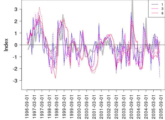
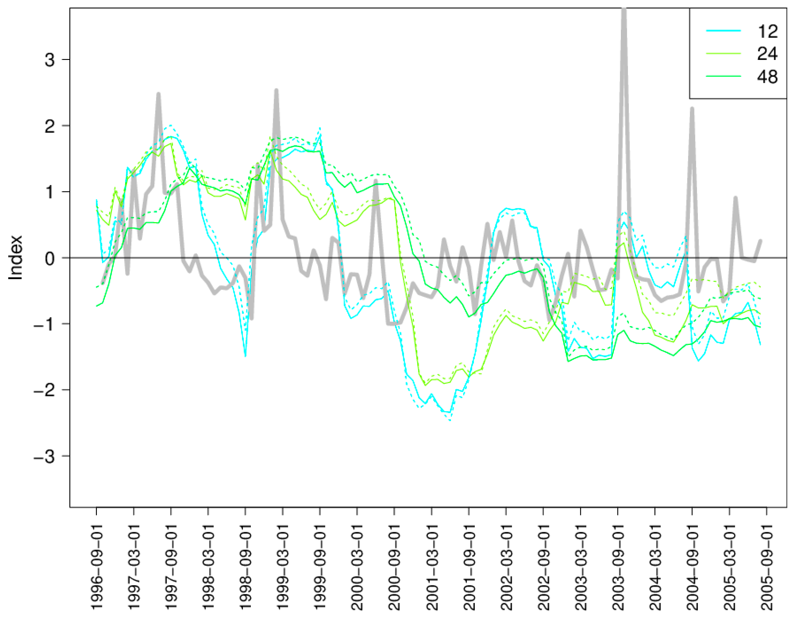
4.1.6. Resilience to Drought

Two interesting events were captured in the contemporary water balance. First, the drought of 2000/2001 invoked stage 3 water restrictions for the first time on record. Second, the seven-day atmospheric river event of October 2003 brought more than a quarter of the annual total water. These large precipitation events have caused damage and loss of life in this province [38] and are expected to occur more often in the future [39,40]. Additionally, they contribute to longer dry seasons by arriving when soils are already saturated and running off quickly reducing water availability later in the year [41].
Figure 4. Absolute value of the simulated change in storage minus the observed change in storage (error) versus the monthly spill, consumption, fisheries release, precipitation, evaporation and inputs from council. Values during spill events are shown in green.
Climate 03 00241 g004
To estimate the resilience of this system to persistent drought, a worst-case drought scenario was developed using events from 1996 to 2005. The SR is a system with a strong seasonality. On average over the contemporary water balance, water surplus during the wet season (October to March) is five times greater than water deficit during the dry season (April to September). The wet season with the lowest precipitation amount was October 2000 to March 2001 with 703 mm (Figure 6). The dry season with the highest evaporation was April to September 1998 with 706 mm (Figure 7). Inflows, precipitation, and evaporation from the 1998 dry season and the inflows, precipitation, and evaporation from the 2000/2001 wet season were taken as analogues of a warmer, drier climate.
Figure 5. Values of simulated change in storage minus the observed change in storage (error) versus monthly spill, consumption, fisheries release, precipitation, evaporation and inputs from Council when spill events did not take place.
Climate 03 00241 g005
Figure 6. Divergence of monthly precipitation versus average precipitation for that month (grey), divergence in wet season with lowest precipitation (black) and largest divergence from monthly average value (blue).
Climate 03 00241 g006
Figure 7. Divergence of monthly evaporation versus average evaporation for that month (grey), divergence in dry season with highest evaporation (black) and largest divergence from monthly average value (red).
Climate 03 00241 g007
The scenario was started with storage equivalent to average 1 April volumes (147,020,355 m3). 1 October volumes were computed by subtracting outflows (37,226,749 m3), adding precipitation (1,013,101 m3), subtracting evaporation (4,990,990 m3) and adding inflows (4,266,779 m3) from April to September 1998 values. The following 1 April volumes were computed by subtracting outflows (23,403,386 m3), adding precipitation (4,972,888 m3), subtracting evaporation (1,205,968 m3) and adding inflows (29,102,974 m3) from October 2000 to March 2001 values until storage volumes fell below 67,548,021 m3 or 170 masl (Figure 8).
Figure 8. The SPEI and wet season under a worst-case drought scenario.
Climate 03 00241 g008
For average storage conditions (184.9 masl) on 1 April 1, if extreme conditions persisted it would take until start of the third wet season for the water to reach inaccessible levels (170 masl) if water restrictions were not in place (Figure 8). However, if water restrictions were in place as they were in dry season of 2001, supplies would not fall below 170 masl until the fifth wet season.
The CRD has done well to increase the capacity of the SR by 75% in 2004. It is now resilient to persistent drought conditions until the start of the third wet season following initial dry season based on our worst-case drought scenario. Full characterization, simulation and prediction of drought would require sophisticated analysis, expert teams and high-resolution models coupled at the surface [42]. Weakening of the circumpolar vortex with decreased temperature differences between the Arctic and mid-latitudes is one thought cause of drought conditions in western North America [43]. More investigation of the 2000/2001 drought, such as identification of the driving forces in this event, could help to predict their occurrence and persistence in the future using GCMs. In the next section we will look into how this event compares to those of the past.

4.2. Long-Term Water Availability (1919–2005)

SPEI and SPI can be calculated with a range of time scales from one to 48 months. One, three and six month (Figure 9) and 12, 24 and 48 month (Figure 10) SPEI and SPI were compared to the standardized runoff values for the SR, which did not include intermittent contributions from Council Creek. Each index was run for the whole available record (1919–2005) providing a several year lead up to the start of the contemporary water balance. SPEI was implemented using the Thornthwaite evaporation estimate. The three-month time scale versions have the highest correlation with the standardized runoff, R2 equaled 0.93 for SPEI and 0.90 for SPI (Table 7). The SPEI and SPI follow each other closely for most of the short-term record. These indices capture variation in drought or moisture that have been documented by the contemporary water balance, including the 2000/2001 drought. Therefore, the three-month time scale SPEI and SPI are used for the investigating long-term water balance.
Figure 9. The Standard Precipitation Evaporation (SPEI) and Standard Precipitation (SPI) Indices for the one, three, and six-month time scale and the standardized runoff for the SR (grey) over 1996–2005.
Climate 03 00241 g009
Figure 10. The SPEI and SPI for the 12, 24, and 48-month time scale and the standardized runoff for the SR (grey) over 1996–2005.
Climate 03 00241 g010
SPEI and SPI are similar over long-term record in their minimum and maximum values, with slightly greater magnitudes in SPEI (Table 8). According to the SPEI and SPI, the drought that occurred in 2000/2001 was similar in magnitude to droughts that lasted for several years in the late 80 s and late 40 s and close to a decade in the late 20 s/early 30 s (Figure 11). Thus, more persistent droughts have happened in the past. SPEI has a negative trend over the long-term record −7.42 × 10⁻⁶ (unitless) while the SPI has a positive trend of 8.83 × 10⁻⁷ (unitless) over the same period (Figure 11). Both trends are insignificant and close to zero.
Table 7. Pearson’s R2 correlation value of standardized runoff versus SPEI and SPI using one, three, six, 12, 24 and 48 month time scales over 1996 to 2005.
Time Scale136122448
SPEI0.310.930.860.580.450.17
SPI0.270.900.890.580.450.16
Table 8. Summary statistics for three-month time scale SPEI and SPI over 1919 to 2005.
SPEISPI
MIN−2.92−2.43
1stQ−0.67−0.76
MED0.01−0.01
AVE0.000.00
3rdQ0.660.74
MAX3.022.55
The SPEI trend for 1950 to 2009 is between −0.05 and 0.10 for this region according to Begueria et al. [11] based on the Thornthwaite evaporation method. When computed for 1950 to 2005 using our implementation of the SPEI and SPI, both have negative trends, although still less than 0.001 in magnitude. Thus, trends under our validated method with our local data fall within the range found by Begueria et al. [11]. Trends towards wetter conditions are detected here with SPEI when used with the Hargreaves and Penman-Monteith evaporation methods [11].
Validating the SPEI that uses the more simplified Thornthwaite (1948) [44] method to estimate evaporation against the standardized runoff suggests it sufficient for estimating moisture availability over the long term. However, this SPEI implementation relies on mean temperature. Changes in the diurnal temperature range increase the uncertainties associated with using this metric as a proxy [45] and minimum temperatures have increased more so than maximum temperatures in this area of British Columbia, Canada over the 20th century [14]. When including other physical principles that take into account available energy, humidity and wind speed different trends in drought can result [12].
Some challenges for this work include station movement and changes in operational methods for both the precipitation and temperature gauges, including infilling the Sooke temperature record using data from the nearby Shawnigan Lake station from 1966 to 1995. Drought conditions are projected to increase with global temperatures as the ratio of precipitation to potential evapotranspiration decreases over land surfaces [46].
Figure 11. The Standardized Precipitation Evaporation Index (SPEI) and the Standardized Precipitation Index (SPI) over 1919 to 2005 implemented with the three-month timescale.
Climate 03 00241 g011

5. Conclusions

This was the first study to fully estimate the near-term (1996–2005) water balance of the Sooke Reservoir. All inputs and outputs were accounted for. Simulated change in storage matched observed change in storage from May to September and during drier wet seasons (i.e., 2000/2001) and post dam construction, which suggests estimates of evaporation and runoff are robust. A worst-case drought scenario was constructed from the driest wet season (October 2000 to March 2001) and driest dry season (April 1998 to September 1998). Under the current population, without water restrictions supplies would last two years. Two drought indices were used as proxies of long-term water balance conditions, the three-month timescale SPEI and SPI, which were shown to capture the 2000/2001 drought and correlate strongly with standardized runoff over the contemporary water balance. Non-significant small (close to zero) trends towards more negative SPEI values and towards more positive SPI values were found over 1919 to 2005. The 2000/2001 drought was large in magnitude in comparison to others on record back to 1919 according to the SPEI, but there were events of similar magnitude which persisted for longer historically. By testing the SPEI and SPI against the fully characterized contemporary water balance we are more confident in our understanding of the influence of climate on water availability in this reservoir. As more years stretch out after the raising of the Sooke Dam (2002) the contemporary water balance should be extended to include the most recent record and further work put into investigating the cause of water loss during spill and high precipitation events. Population is expected to increase by 26% by 2026 in the Greater Victoria Area and along with it total consumption [17]. Increases in consumption ought to be considered in future estimates of the resiliency of the SR to changes in climate and drought.

Acknowledgments

The authors would like to thank John Gibson for guiding some of the early stages of this work, particularly with evaporation and water balance modelling. Daniel Peters is acknowledged for his assistance with estimating evaporation, precipitation and storage and assessing the water balance. Martin Lacroix aided the hydrologic modelling and installation of hydrologic monitoring devices. David Hutchinson guided the set-up and calibration of the HBV hydrologic model. Finally, we owe much to Sigi Gaudavicius who made the operation and management of the SR transparent. He assembled, shared and supported the use of the SR data and enabled our access to the SR field sites. Financial support was provided by a Natural Sciences and Engineering Research Council Discovery Grant to one of the co-authors, Environment Canada and Water Services at the Capital Regional District Victoria, BC, Canada.

Author Contributions

Arelia Werner led the preparation of the manuscript, analyzed the data, created the tables and figures and interpreted results. Terry Prowse and Barry Bonsal made substantial contributions to the design of the study, interpretation of results and provided constructive reviews of the manuscript.

Conflicts of Interest

The authors declare no conflict of interest.

References

  1. Marsalek, J.; Watt, W.E.; Lefrancois, L.; Boots, B.F.; Woods, S. Municipal Water Supply and Urban Development; Environment Canada, National Water Research Institute: Burlington, ON, Canada, 2004. [Google Scholar]
  2. Dai, A.; Trenberth, K.E.; Qian, T. A global dataset of Palmer Drought Severity Index for 1870–2002: Relationship with soil moisture and effects of surface warming. J. Hydrometeorol. 2004, 5, 1117–1130. [Google Scholar] [CrossRef]
  3. Solomon, S.; Qin, D.; Manning, M.; Chen, Z.; Marquis, M.; Averyt, K.B.; Tignor, M.; Miller, H.L. Contribution of Working Group I to the Fourth Assessment Report of the Intergovernmental Panel on Climate Change; Cambridge University Press: Cambridge, UK, 2007. [Google Scholar]
  4. Winter, T.C. Uncertainties in estimating the water balance of lakes. Water Resour. Bull. 1981, 17, 82–115. [Google Scholar] [CrossRef]
  5. Niu, J.; Shen, C.; Li, S.G.; Phanikumar, M.S. Quantifying storage changes in regional Great Lakes watersheds using a coupled subsurface-land surface process model and GRACE, MODIS products. Water Resour. Res. 2014, 50, 1–19. [Google Scholar] [CrossRef]
  6. Capital Regional District. Compartment Analysis; Capital Regional District: Victoria, BC, Canada, 2001; p. 23. [Google Scholar]
  7. Walker, D. Victoria’s Strategy When Facing the Drought. Available online: http://www.esemag.com/archive/0302/victoria.html (accessed on 1 February 2007).
  8. Kolisnek, P. Assessing the Vulnerability of Greater Victoria’s Drinking Water Supply System to Climate-Induced Water Shortages; University of Guelph: Guelph, ON, Canada, 2005; p. 179. [Google Scholar]
  9. Guttman, N.B. Comparing the palmer drought index and the standardized precipitation index. J. Am. Water Resour. Assoc. 1998, 34, 113–121. [Google Scholar] [CrossRef]
  10. Vincente-Serrano, S.M.; Begueria, S.; Lopez-Moreno, J.I. A multiscalar drought index sensitive to global warming: The standardized precipitation evapotranspiration index. J. Clim. 2010, 23, 1696–1718. [Google Scholar] [CrossRef]
  11. Begueria, S.; Vicente-Serrano, S.M.; Reig, F.; Latorre, B. Standardized precipitation evapotranspiration index (SPEI) revisited: Parameter fitting, evapotranspiration models, tools, datasets and drought monitoring. Int. J. Climatol. 2014, 34, 3001–3023. [Google Scholar]
  12. Sheffield, J.; Wood, E.F.; Roderick, M.L. Little change in global drought over the past 60 years. Nature 2012, 491, 435–438. [Google Scholar] [CrossRef] [PubMed]
  13. Orlowsky, B.; Seneviratne, S.I. Elusive drought: Uncertainty in observed trends and short- and long-term CMIP5 projections. Hydrol. Earth Syst. Sci. 2013, 17, 1765–1781. [Google Scholar] [CrossRef]
  14. Rodenhuis, D.R.; Bennett, K.E.; Werner, A.T.; Murdock, T.Q.; Bronaugh, D. Hydro-Climatology and Future Climate Impacts in British Columbia; University of Victoria: Victoria, BC, USA, 2009; p. 132. [Google Scholar]
  15. CRD. CRD Water Services-Sooke Reservoir Project Description; Capital Regional District: Victoria, BC, Canada, 2006. [Google Scholar]
  16. Green, J.; Gillie, R. An Environmental Impact Assessment of the Proposed Expansion of the Sooke Lake Reservoir: Final Report; Axys Environmental Consulting Ltd.: Victoria, BC, Canada, 1994; p. 217. [Google Scholar]
  17. CRD. 2004 Review of the Strategic Plan for Water Management; Capital Regional District: Victoria, BC, Canada, 2004; p. 69. [Google Scholar]
  18. Nowlin, W.H.; Davies, J.-M.; Nordin, R.N.; Mazumder, A. Effects of water level fluctuation and short-term climate variation on thermal and stratification regimes of a British Columbia Reservoir and Lake. J. Lake Reserv. Manag. 2004, 20, 1–19. [Google Scholar] [CrossRef]
  19. Spafard, M.A.; Nowlin, W.H.; Davies, J.M.; Mazumder, A. A Morphometric Atlas of Selected Lakes in Southern British Columbia: Vancouver Island, and the Kootney Region; National Sciences and Engineering Research Council: Victoria, BC, Canada, 2002; p. 52. [Google Scholar]
  20. Kenny, S. Aquifers of the Capital Regional District; Capital Regional District: Victoria, BC, Canada, 2004. [Google Scholar]
  21. Fairbairn, D. The Statistical Distribution of Precipitation in the Sooke Lake Reservoir Catchment Area; Department of Geography, University of Victoria: Victoria, BC, Canada, 2004; p. 24. [Google Scholar]
  22. Bergstrom, S. The HBV Model: In Singh, V.P., Computer Models of Watershed Hydrology; Water Resources Publications: Highlands Ranch, CO, USA, 1995. [Google Scholar]
  23. Lindstrom, G.; Johansson, B.; Persson, M.; Gardelin, M.; Bergstrom, S. Development and test of the distributed HBV-96 hydrological model. J. Hydrol. 1997, 201, 272–288. [Google Scholar] [CrossRef]
  24. WMO. tercomparison of Models of Snowmelt Runoff; Operational Hydrology Report; WMO: Geneva, Switzerland, 1986. [Google Scholar]
  25. Nash, J.E.; Sutcliffe, J.V. River flow forecasting through conceptual models part I—A discussion of principles. J. Hydrol. 1970, 10, 282–290. [Google Scholar] [CrossRef]
  26. Penman, H.L. Natural evaporation from open water, bare soil, and grass. Proc. R. Soc. Lond. 1948, A193, 120–146. [Google Scholar] [CrossRef]
  27. Winter, T.C.; Rosenberry, D.O.; Sturrock, A.M. Evaluation of 11 equations for determining evaporation for a small lake in the North Central United States. Water Resour. Res. 1995, 31, 983–993. [Google Scholar] [CrossRef]
  28. Rosenberry, D.A.; Winter, T.C.; Buso, D.C.; Likens, A.G.E. Comparison of 15 evaporation methods applied to a small mountain lake in Northeastern USA. J. Hydrol. 2007, 340, 149–166. [Google Scholar] [CrossRef]
  29. Penman, H.L. Vegetation and Hydrology; Tech. Comm. No. 533; Commonwealth Bureau of Soils: Harpenden, UK, 1963; p. 125. [Google Scholar]
  30. Maidment, D.R. Evaporation. In Handbook of Hydrology; McGraw-Hill, Inc.: New York, NY, USA, 1993; pp. 4.1–4.53. [Google Scholar]
  31. Vincente-Serrano, S.M.; Begueria, S. Calculation of the Standardised Precipitation-Evapotranspiration Index. R Packag. 2014. Available online: http://cran.r-project.org/web/packages/SPEI/SPEI.pdf (accessed on 8 November 2013).
  32. Lavers, D.A.; Villarini, G.; Allan, R.P.; Wood, E.F.; Wade, A.J. The detection of atmospheric rivers in atmospheric reanalyses and their links to British winter floods and the large-scale climate circulation. J. Geophys. Res. 2012, 117, 1–13. [Google Scholar] [CrossRef]
  33. Wang, S.; McKenney, D.W.; Shang, J.; Li, J. A national-scale assessment of long-term water budget closures for Canada’s watersheds. J. Geophys. Res. Atmos. 2014, 119, 8712–8725. [Google Scholar] [CrossRef]
  34. Wang, S.; Huang, J.; Yang, D.; Pavlic, G.; Li, J. Long-term water budget imbalances and error sources for cold region drainage basins. J. Geophys. Res. Atmos. 2014. [Google Scholar] [CrossRef]
  35. Flerchinger, G.N.; Cooley, K.R. A ten-year water balance of a mountainous semi-arid catchment. J. Hydrol. 2000, 237, 86–99. [Google Scholar] [CrossRef]
  36. Gao, H.; Tang, Q.; Ferguson, C.R.; Wood, E.F.; Lettenmaier, D.P. Estimating the water budget of major U.S. river basins via remote sensing. Int. J. Remote Sens. 2010, 31, 3955–3978. [Google Scholar] [CrossRef]
  37. Pan, M.; Sahoo, A.K.; Troy, T.J.; Vinukollu, R.K.; Sheffield, J.; Wood, E.F. Multisource estimation of long-term terrestrial water budget for major global river basins. J. Clim. 2012, 25, 3191–3206. [Google Scholar] [CrossRef]
  38. Ministry of the Environment, British Columbia. Climate Change Impacts Extreme Weather Events are Costly and More Frequent, Province of British Columbia, Canada. Available online: http://www2.gov.bc.ca/gov/topic.page?id=BE3D1E436EE14ADE8255FA0AD060659C (accessed on 16 September 2014).
  39. Dettinger, M. Climate change, atmospheric rivers, and floods in California—A multimodel analysis of storm frequency and magnitude changes. J. Am. Water Resour. Assoc. 2011, 47, 514–523. [Google Scholar] [CrossRef]
  40. Lavers, D.A.; Allan, R.P.; Villarini, G.; Lloyd-Hughes, B.; Brayshaw, D.J.; Wade, A.J. Future changes in atmospheric rivers and their implication for winter flooding in Britian. Environ. Res. Lett. 2013, 8, 1–8. [Google Scholar] [CrossRef]
  41. Coats, R.; Costa-Cabral, M.; Riverson, J.; Reuter, J.; Sahoo, G.; Schladow, G.; Wolfe, B. Projecting 21st century trends in hydroclimatology of the Tahoe Basin. Clim. Chang. 2013, 116, 51–69. [Google Scholar] [CrossRef]
  42. Hanesiak, J.M.; Stewart, R.E.; Bonsal, B.R.; Harder, P.; Lawford, R.; Aider, R.; Amiro, B.; Atallah, E.; Barr, A.G.; Black, T.A.; et al. Characterization and summary of the 1999–2005 Canadian Prairie Drought. Atmos. Ocean 2001, 49, 421–452. [Google Scholar]
  43. Berkowitz, R. A Dry State in the West. Availabale online: http://scitation.aip.org/content/aip/magazine/physicstoday/news/10.1063/PT.5.4004 (accessed on 8 September 2014).
  44. Thornthwaite, C.W. An approach toward a rational classification of climate. Geogr. Rev. 1948, 38, 55–94. [Google Scholar] [CrossRef]
  45. Roderick, M.L.; Farquhar, G.D. The cause of decreased pan evaporation over the past 50 years. Science 1999, 298, 1410–1411. [Google Scholar]
  46. Sherwood, S.; Fu, Q. A drier future? Science 2014, 343, 737–739. [Google Scholar] [CrossRef] [PubMed]

