Article

ISSA-Based Evaluation Method of Actual Navigation Performance of Rotorcraft Logistics Unmanned Aerial Vehicles

1
General Aviation Department, Civil Aviation Management Institute of China, Beijing 100102, China
2
CAAC Key Laboratory of General Aviation Operation, Civil Aviation Management Institute of China, Beijing 100102, China
3
Hangzhou Antwork Technology Co., Ltd., Hangzhou 311100, China
*
Author to whom correspondence should be addressed.
Aerospace 2025, 12(4), 357; https://doi.org/10.3390/aerospace12040357
Submission received: 12 February 2025 / Revised: 7 April 2025 / Accepted: 15 April 2025 / Published: 17 April 2025

Abstract

:
In response to the demand for the evaluation of the actual navigation performance (ANP) of rotorcraft logistics uncrewed aerial vehicle (UAV) navigation systems in urban scenarios, this paper proposes a method for evaluating the ANP of rotorcraft logistics UAVs based on the Improved Sparrow Search Algorithm (ISSA). Taking ANP as the optimization objective, an optimization model for the ANP of rotorcraft logistics UAVs is constructed. Based on the probability of the UAV’s actual position falling within the error circle, an initial population strategy based on probabilistic decision-making is designed, and an adaptive dynamic step size strategy and dynamic compression search strategy are proposed to improve the traditional Sparrow Search Algorithm (SSA), enhancing the algorithm’s ability of optimization and to escape local extremum. The contribution of this paper mainly includes constructing the ANP optimization model and designing the ISSA method. Experimental results show that the proposed method can effectively estimate ANP, achieve onboard performance monitoring and warning, and ensure the required navigation performance (RNP) and flight safety of UAVs.

1. Introduction

In 2023, the application of uncrewed aerial vehicles (UAVs) in logistics in Shenzhen of China reached 600,000 sorties. The use of civil UAVs for logistics in urban low-altitude airspace is gradually transitioning from validation to regular commercial operations [1]. The urban low-altitude airspace environment is complex, and the ultra-low flight altitude, along with numerous artificial structures and obstacles, limits the available space for UAVs. To maintain a safe distance from buildings, obstacles, and other aircraft, the navigation performance of logistics UAVs must meet operational safety requirements.
The navigation of logistics UAVs primarily uses Global Navigation Satellite Systems (GNSS) and Inertial Navigation Systems (INS). The navigation performance requirements for logistics UAVs can be formulated in accordance with the Required Navigation Performance (RNP) standards set by the International Civil Aviation Organization (ICAO) [2,3]. The navigation system must meet the required accuracy during 95% of flight time and possess performance monitoring and alarm capabilities [4,5,6].
Therefore, logistics UAVs need to evaluate the real-time Actual Navigation Performance (ANP) of the navigation system and monitor its operational status. ANP is determined by the cross-track error and along-track error, which reflect the ANP of the system, as shown in Figure 1. It is defined as the probability circle radius (95%) of the estimated position uncertainty (EPU) of the navigation system [7]. The estimated position in Figure 1 is the estimated position from the navigation system, and the Flight Technical Error (FTE) is the error between the estimated position and the required position [8]. RNP is the minimum requirement for the accuracy of the navigation system in a specific airspace or route, which stipulates the standards of positioning accuracy, integrity, and continuity that an aircraft must meet during flight (for example, RNP 0.3 means that the lateral error does not exceed 0.3 nautical miles). ANP is the real-time performance index of the airborne navigation system, which is calculated by the accumulated errors of sensors (such as GNSS and INS). The core relationship between them is that ANP must always be less than or equal to RNP in order to meet the flight safety requirements. If ANP exceeds RNP (for example, due to signal interference or sensor failure), the crew should immediately take mitigation measures (such as switching navigation sources or changing routes). This dynamic comparison ensures the real-time monitoring of navigation performance and is the key foundation of PBN (performance-based navigation) operation.
Much research on Actual Navigation Performance (ANP) estimation methods has been conducted in the traditional crewed aircraft sector. Yao, X. et al. designed an efficient numerical integration algorithm that combines the Gauss three-point quadrature rule with the composite Simpson’s rule to effectively estimate ANP, addressing the requirements for airborne navigation systems based on the performance proposed by the International Civil Aviation Organization (ICAO). This method meets the navigation performance requirements for civil aircraft [9]. Zhang, N. proposed both approximate and precise calculation methods for ANP based on two actual flight paths in China, demonstrating an effective assessment of navigation performance [10]. Ma, H. et al. introduced a real-time ANP estimation method based on position covariance matrices to enhance the overall navigation performance of civil aircraft, achieving high assessment accuracy that meets the Required Navigation Performance (RNP) requirements [11,12]. Dautermann, T. et al. introduced a novel calculation method for the ANP estimation of multi-constellation systems, which complies with Performance-Based Navigation (PBN) operational standards [13]. Džunda, M. et al. developed an ANP calculation method for ground-based navigation systems, enabling accurate computation [14]. Peng, X. et al. focused on the estimation of ANP in INS/GNSS navigation systems, utilizing the two-dimensional Gaussian distribution characteristics of navigation data for real-time ANP estimation. This method is practical for engineering applications [15]. Teng, J. et al. proposed a real-time ANP estimation approach and validated it on the BlueSky simulation platform to solve the problem of a lack of simulation environment validation in existing ANP estimation methods. It provides new insights for validating other flight error estimation algorithms [16]. Wang, L. et al. designed a calculation scheme of ANP assessment for different navigation modes in order to address the issues of low performance and accuracy in traditional navigation methods. They leveraged concepts such as the dilution of precision (DOP), error covariance, and Rayleigh distribution, offering a new solution for civil aircraft ANP estimation [17].
Overall, there is little research on ANP estimation for urban rotorcraft logistics UAVs. A new idea for ANP estimation has been provided [9] by transforming the problem into an optimization issue, with ANP as the objective of optimization and solving with intelligent optimization algorithms. Therefore, there is an urgent need for a high-precision intelligent optimization method to solve the optimization model for real-time ANP estimation.
Currently, there are some well-known intelligent optimization algorithms like Genetic Algorithms, Particle Swarm Optimization, and Simulated Annealing, as well as several of the latest proposed intelligent optimization algorithms, Butterfly Optimization Algorithm, Sine-Cosine Optimization Algorithm, Cuckoo Search Algorithm, and Sparrow Search Algorithm (SSA) [18,19]. Specifically, the Sparrow Search Algorithm, introduced by Xue, J. et al. in 2020 [20], is a novel swarm intelligence algorithm. It has advantages in solving optimization problems, including high-accuracy solutions, rapid convergence speed, and great stability. It has been widely applied in areas such as fault diagnosis [21], model parameter identification [22], and model optimization [23]. Therefore, SSA can be introduced to address the optimization problem of real-time ANP estimation.
We have proposed an ANP estimation method for rotorcraft logistic UAVs based on the Improved Sparrow Search Algorithm (ISSA). First, the lengths of the semi-major and semi-minor axes of the error ellipse are determined based on the position error covariance, which converts the error probability calculation into a circular region. We calculate the probability of the UAV’s actual position falling within the error circle and design a fitness function with ANP as the optimization objective to create an optimization model for the ANP of rotorcraft UAVs. Furthermore, based on the strengths and weaknesses of the SSA and the ANP estimation requirements, a probability-based initial population strategy is designed. To enhance the directional and rapid search capabilities of the sparrow search algorithm (SSA), an adaptive dynamic step size strategy and a dynamic compression search strategy are proposed to improve the traditional SSA, thereby improving the algorithm’s optimization capability and its ability to avoid local extrema. The ISSA is employed to optimize and solve the online estimation model for ANP, effectively obtaining the ANP values for rotorcraft logistics UAVs. It not only improves the accuracy of the ANP estimates but also effectively evaluates the performance of the navigation system, providing warning monitoring data for the UAV navigation system and ensuring the safe flight of the UAVs.
This paper is structured as follows. In Section 2, we analyze the research status of ANP. In Section 3, we construct an optimization model for the ANP of rotorcraft logistics UAVs. In Section 4, we design a solution method for the ANP optimization model based on ISSA. In Section 5, we analyze the experiment results. Finally, Section 6 concludes the paper.

2. Research Status of ANP

At present, lots of scholars have carried out relevant research on the ANP of crewed aircraft. See Table 1 for details.
According to Table 1, the research on ANP has the following characteristics:
(1) Method Evolution. From static to dynamic research, [9,10] adopts an off-line numerical calculation method, while [11,12,15] realizes real-time covariance update, reflecting the paradigm shift of ANP evaluation from after-flight analysis to online monitoring. From single sensor to combined sensor, early research (such as [14]) focused on a single navigation source, while [13,17] reflected the trend of multi-constellation/multi-mode integration, which met the requirements of modern avionics system integration.
(2) Technical limitations. Most literature (such as [9,10,15]) only discusses horizontal ANP, lacking the evaluation method of height channel (such as vertical guidance RNP AR), which is far from the operational requirements of modern PBN.
(3) Engineering realization. The conflict of computing resources, the contradiction between the high-precision matrix operation of references [11,13], the limited computing power of airborne computers, and the lightweight scheme are not given. Sensor dependence and references [11,14,15] all assume that the error covariance is known, but in practice, the IMU/GNSS error characteristics deteriorate with the use time, and there is no online calibration mechanism.
(4) Research object. The existing research (such as [9,11,12,13,17]) mainly focuses on large civil airliners (such as Boeing and Airbus series), and its ANP evaluation method is based on high-precision inertial navigation (INS) and multimode GNSS. There is a lack of targeted research on UAV navigation performance. UAVs (especially logistics UAVs) usually use low-cost sensors (such as consumer GNSS and visual navigation), and their error characteristics are significantly different from those of traditional aviation navigation systems (such as civil aviation GNSS/INS).

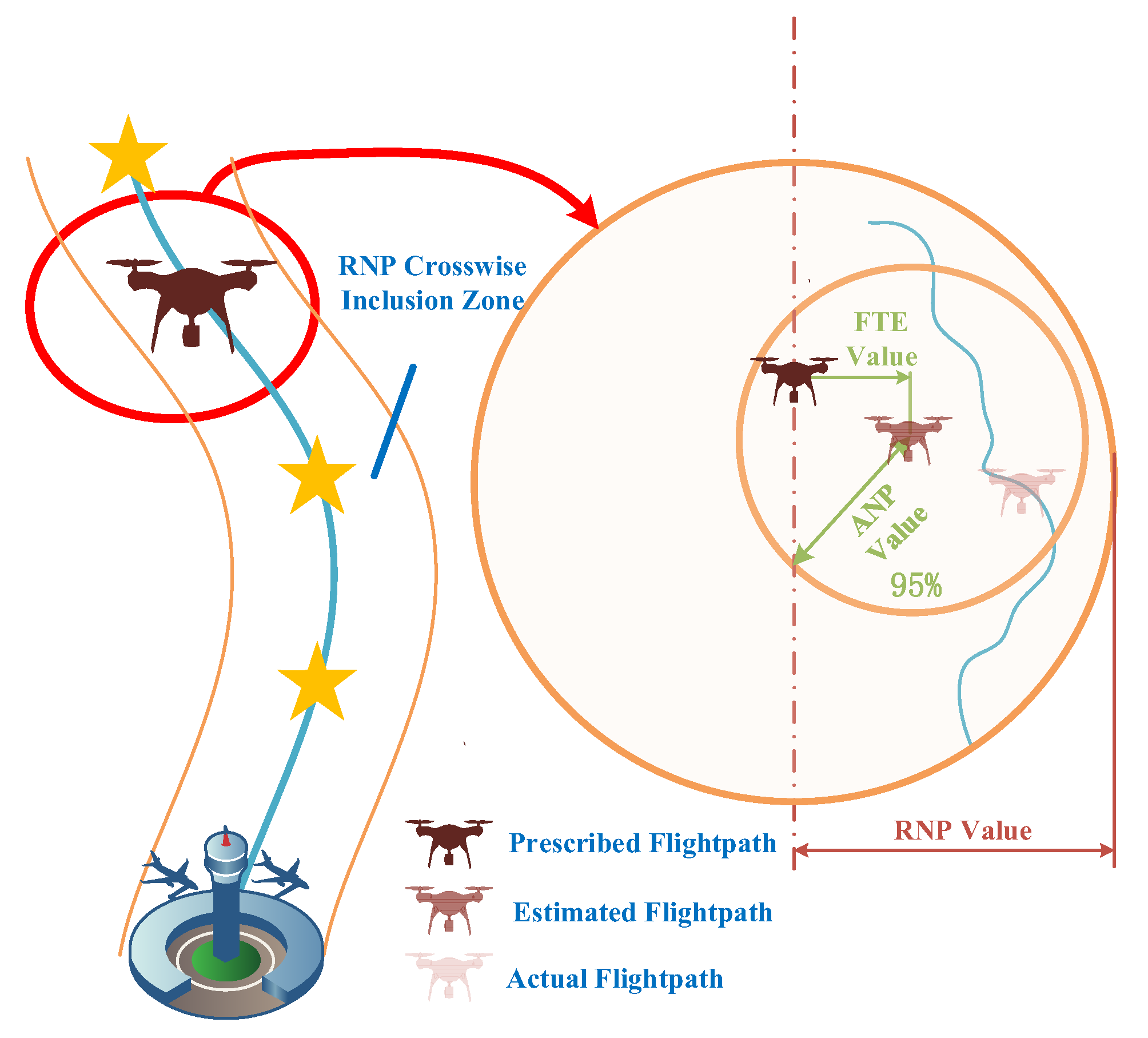
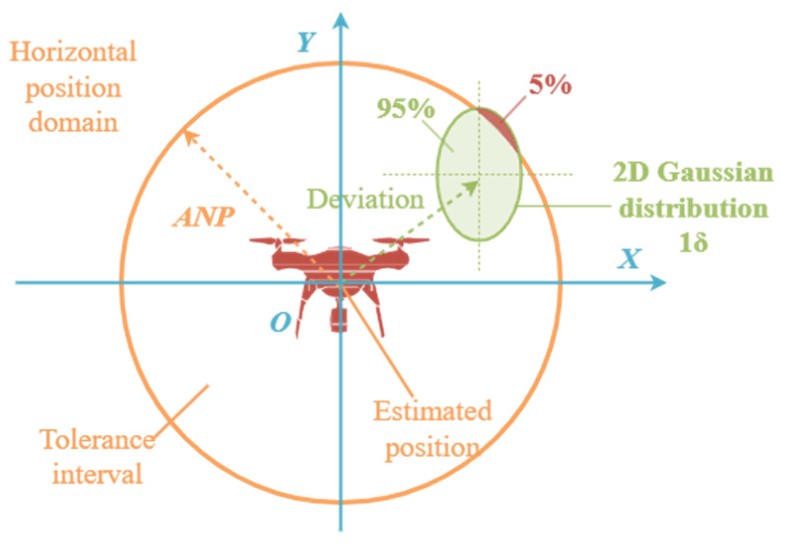
3. Optimization Model for the ANP of Rotorcraft Logistics UAVs

For the rotorcraft UAVs equipped with a GNSS module and an IN system, an integrated navigation system can be constructed. By using Kalman filtering, the position error covariance matrix can be obtained as shown below.
P x y = σ x 2 σ x y 2 σ x y 2 σ y 2
where σ x 2 , σ y 2 are the variances of Δ x and Δ y , while σ x y 2 is the covariance of Δ x and Δ y .
When there is a bias in the position estimation of the integrated navigation system, the center of the error distribution in the horizontal position domain is no longer located at the origin centered on the estimated position but rather at the position of the bias, as illustrated in Figure 2. Therefore, it is necessary to design a two-dimensional Gaussian integral method to obtain the radius of the integral circular area at a specific probability, thereby enabling the evaluation of the ANP.
The eigenvalues of the position error covariance matrix can be obtained using Equation (1) as follows.
λ 1 , 2 = ( σ x 2 + σ y 2 ) ± ( σ x 2 σ y 2 ) + 4 σ x y 4 2
The lengths of the major and minor axes of the error ellipse 1 σ can be obtained [9] as below.
σ max = max λ 1 , λ 2 σ min = min λ 1 , λ 2
The ANP of traditional methods can be calculated by
ANP = k σ max
where k is the conversion factor of error ellipse, k = 2.4477.
To accurately calculate the navigation performance radius, we adopt the circular error probability. Thus, the probability of the UAV’s actual position falling within the error circle is represented as
Q = Δ x 2 + Δ y 2 < r 2 f ( Δ x , Δ y ) d Δ x d Δ y = 4 0 r 0 r 2 4 y 2 f ( Δ x , Δ y ) d Δ x d Δ y
where f ( Δ x , Δ y ) = 1 2 π σ max σ min exp 1 2 Δ x 2 σ max 2 + Δ y 2 σ min 2 , r denotes the radius of the error circle, which represents the precise ANP.
The probability is calculated by combining the Gauss three-point quadrature rule and the composite Simpson’s rule.
h ( Δ y ) = 0 r 2 Δ y 2 f ( Δ x , Δ y ) d Δ x
where Δ x = r 2 Δ y 2 2 v + r 2 Δ y 2 2 . v is an intermediate variable with no specific physical meaning, just a mathematical symbol.
The integration of Equation (6) over the interval [−1, 1] can be expressed as
h ( Δ y ) = 1 1 f r 2 Δ y 2 2 v + r 2 Δ y 2 2 , Δ y r 2 Δ y 2 2 d v
We apply the three-point Gaussian quadrature rules over the interval [−1, 1] and obtain
h ( Δ y ) h ˜ ( Δ y ) = 5 9 f r 2 Δ y 2 2 1 15 5 , Δ y + 8 9 f r 2 Δ y 2 2 , Δ y + 5 9 f r 2 Δ y 2 2 1 + 15 5 , Δ y
The interval Δ y over [0,r] is divided into n equal parts where the step size is r n , and Δ y s denotes the equidistant nodes of subintervals, with s = 1, 2, …, n. In particular, the midpoint of Δ y s , Δ y s + 1 is denoted as Δ y s + 1 2 . Using the composite Simpson’s rule [9], we obtain
Q = 4 0 r 0 r 2 Δ y 2 f ( Δ x , Δ y ) d Δ x d Δ y 4 0 r h ˜ ( Δ y ) d Δ y 4 r 6 n h ˜ ( 0 ) + h ˜ ( r ) + 2 i = 1 n 1 h ˜ ( Δ y i ) + 4 i = 1 n 1 h ˜ ( Δ y i + 1 2 )
By substituting Equation (8) into Equation (9), the corresponding error circle radius r can be obtained by the dichotomy method within the interval [ka,kb] of the semi-major and semi-minor axes of the probability error ellipse of Q = 95 % , which gives the value of ANP.
Thus, the ANP evaluation optimization model for the UAV is constructed with r as the optimization objective as below.
min f r = min 4 r 6 n h ˜ ( 0 ) + h ˜ ( r ) + 2 i = 1 n 1 h ˜ ( Δ y i ) + 4 i = 1 n 1 h ˜ ( Δ y i + 1 2 ) 0.95
where r is the error radius and also the ANP value to be determined. Equation (10) represents the optimization model for the ANP evaluation of the UAV, which includes only navigation error information and the ANP to be estimated. Theoretically, in Equation (10), f r = 0 . However, since it is a transcendental equation that cannot be solved directly, it is necessary to find the optimal ANP value that satisfies Equation (10). Therefore, we adopt it as a fitness function with the ANP value as the optimization objective and employ intelligent optimization algorithms to achieve a real-time estimation of the ANP value.

4. Solution Method for the ANP Optimization Model Based on ISSA

The Sparrow Search Algorithm (SSA) has advantages such as simplicity, flexibility, and a low number of parameters. However, it shows a slow convergence and a lack of accuracy in solving complex problems, easily optimized locally. To achieve a high-precision and rapid estimation of the ANP value, we utilize Equation (10) as the optimization objective to improve the traditional SSA.

4.1. Initial Population Strategy Based on Probabilistic Decision-Making

We obtain the ANP value calculated by the traditional methods by Equation (4). The probability value Q of the error circle can be calculated as the error circle radius is 2.4477 σ max . Using the ANP value obtained from the traditional methods and the probability Q, the initial population can be determined. The initial population strategy based on probabilistic decision-making is illustrated in Figure 3. Combined with Figure 3, the core idea of the proposed strategy is to ensure that the coverage area of the green oval part and the orange circle part is 95%.
According to Figure 3, when the probability of the UAV’s actual position falling within the error circle is greater than 95%, the radius of the error circle should be reduced. In contrast, when the probability is less than 95%, the radius should be increased. Based on this, the initial population can be generated using the ANP values obtained from traditional methods, as shown below.
X 2.4477 σ max , δ σ max Q < 95 % 2.4477 σ min , 2.4477 σ max Q 95 %
where δ is a coefficient constant, δ > 2.4477 and usually set as 3.0349, which corresponds to Q = 99% in the traditional methods. In this way, the initial population is generated based on the probability of the UAV’s actual position falling within the error circle, following a uniform distribution.

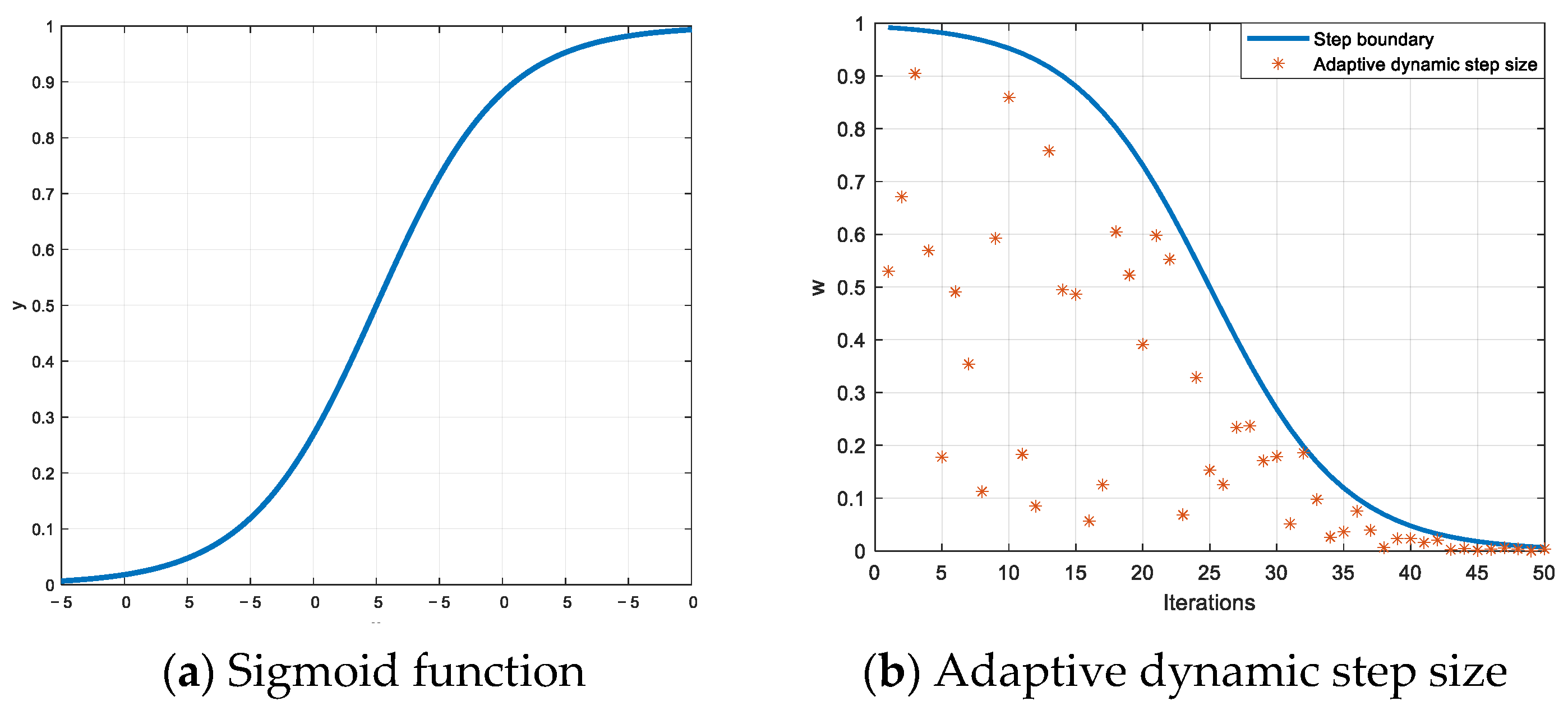
4.2. Adaptive Dynamic Step Size Strategy

In the SSA algorithm, for the discoverer, when R2 < ST, which indicates there are no predators in the environment, the discoverer can perform extensive search operations. R 2 0 , 1 and S T 0 , 1 denote, respectively, the warning and safety values, and the safety value is set to 0.8, while the warning value is a random number following a uniform distribution. However, it may be too broad, lacking specific directionality, making it prone to getting trapped in boundary regions. Therefore, the improved update formula for the discoverer is:
X i , j t + 1 = X i , j t exp i w M R 2 < S T X i , j t + Q r L R 2 S T
where t indicates the current iteration count, j = 1, 2, 3…d with d represents the dimension of the variables for the optimization problem. X i , j t is the position information of the i-th sparrow in the j-th dimension during the t-th iteration. Q r is a random number following a normal distribution. L represents a One Matrix of dimension 1 × d. X b e s t t denotes the global optimum position at the current iteration. w denotes the adaptive dynamic step size, which can be expressed as below.
w = r a n d 1 1 1 + exp 2 Δ x M t + Δ x
where M represents the maximum iteration number. Δ x denotes the domain of the sigmoid function, and generally, we adopt Δ x = 5  rand, where rand is a uniformly distributed random number. The design of adaptive dynamic step size is inspired by the sigmoid function, and the curve of its variation with the number of iterations is shown in Figure 4.
It can be observed in Figure 4b that as the iteration number increases, the step size gradually decreases. It ensures a broad search range as well as the directionality of searching.
For the follower, the introduction of an adaptive dynamic step size improves the updated formula of followers
X i , j t + 1 = w exp X w o r s t t X i , j t i 2 i > n / 2 X p t + 1 + X p t + 1 X i , j t A + L i n / 2
where X p t + 1 is the optimal position currently occupied by the discoverer. A represents a matrix of dimension 1 × d, where each element is 1 or −1, and A + = A T A A T 1 .
The introduction of an adaptive dynamic step size improves the update formula for the investigators as follows
X i , j t + 1 = X b e s t t + w X b e s t t X i , j t f i > f b X i , j t + K X w o r s t t X i , j t f i f w + ε f i = f b
where K 1 , 1 is a random number, f i refers to the fitness value of the current sparrow individual. f b and f w represent the current global best and worst fitness values. ε is the smallest real number to prevent the denominator from 0.

4.3. Dynamic Compression Search Strategy

The introduction of an adaptive dynamic step size is to enable the SSA to approach the optimal position in a directional manner. To avoid the local optima, we design a dynamic compression search strategy, which involves the following evaluations after each iteration:
X i , j t = X b e s t t + ξ r i f   f b t f b t 1 < τ
where ξ is the step size, r 1 , 1 is a random number, and τ is a very small constant. As the number of iterations increases, when the variation in fitness value is less than τ , the dynamic compression search strategy is executed. This is equivalent to reinitializing the search near the optimal position, allowing for a faster and more accurate convergence to the optimal position. We set τ = 10 8 .
The steps for the ISSA are as follows
ISSA
Step 1: Set the population size n, number of discoverers PD, number of investigators SD, warning value R2, safety value ST, maximum number of iterations M, constant τ and ε , and control step size ξ . Calculate the error probability Q corresponding to the ANP obtained from traditional methods.
Step 2: Based on Q, using the initial population strategy based on probabilistic decision-making, initialize the population, calculate the fitness value for each sparrow, and find the current optimal and worst positions.
Step 3: While t < M, calculate the adaptive dynamic step size according to Equation (13).
Step 4: Update the sparrow positions in the interval [1, PD] according to Equation (12).
Step 5: Update the sparrow positions in the interval [PD + 1, n] according to Equation (14).
Step 6: Update the sparrow positions in the interval [1, SD] according to Equation (15).
Step 7: Calculate the fitness value for each sparrow and find the current optimal and worst positions. Activate the dynamic compression strategy and verify if f b t f b t 1 < τ , if yes, update the sparrow positions according to Equation (16).
Step 8: Set t = t + 1 and return to Step 3 until the end.
In summary, the steps for the ISSA-based real-time estimation method of ANP are as follows
ISSA-based real-time estimation method
Step 1: Calculate the variance of the position error of the navigation system σ x 2 and σ y 2 , using Equation (3), determine the lengths of the semi-major and semi-minor axes of the error ellipse. Then, calculate the ANP value using the traditional method based on Equation (3).
Step 2: Calculate the Q corresponding to the ANP from the traditional methods by Equations (8) and (9). Utilize the initial population strategy based on probabilistic decision-making to initialize the population.
Step 3: Calculate the fitness function Equation (10) using Equations (8) and (9).
Step 4: Execute the ISSA algorithm.
Step 5: Obtain the optimal ANP for the current navigation state, increment k by 1 (k = k + 1), and return to Step 1 until the end.

5. Experiments

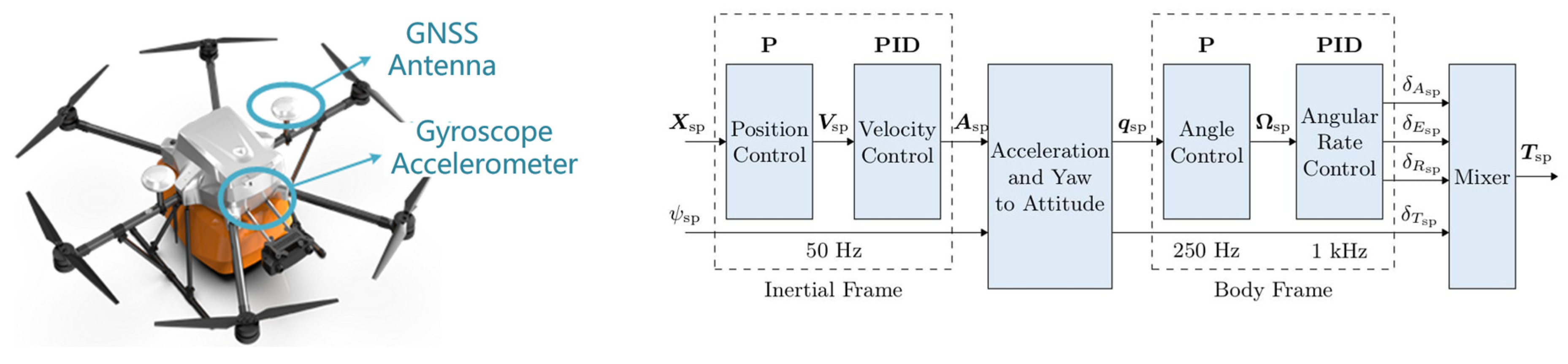
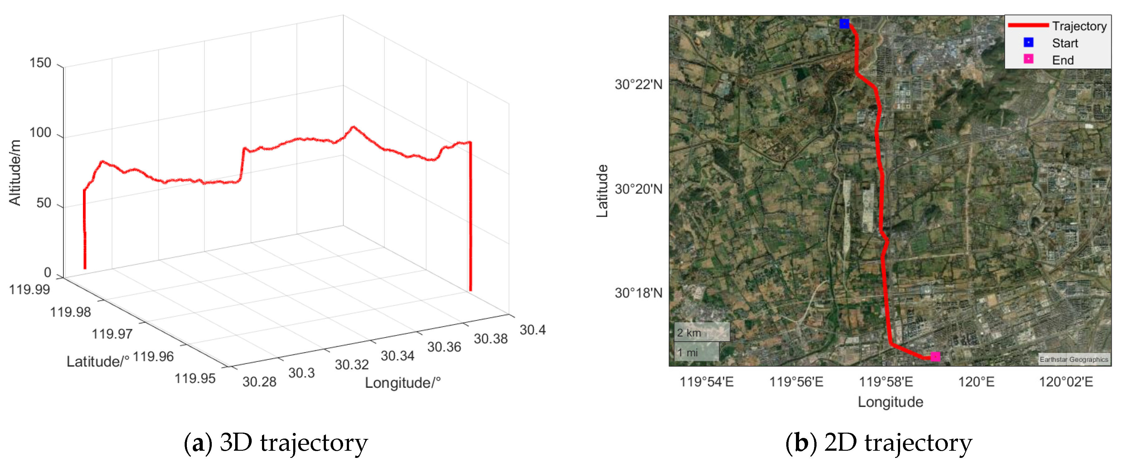
5.1. Experimental Conditions

The experiments of rotorcraft logistics UAVs were conducted in Yuhang District, Hangzhou, Zhejiang Province, to evaluate the ANP. The operating temperature range was −5 °C~45 °C. Operating climatic conditions were moderate rain and wind force below level 5. UAV take-off weight and category were 15.5 kg, and III. Operation mode was over the horizon route flight. The inertial devices and GNSS parameters are in Table 2. A schematic diagram of the inertial devices and the rotorcraft logistics UAV is shown in Figure 5. The flight duration was 1120.7 s, with the flight trajectory illustrated in Figure 6.
In the process of validating the ANP of the rotorcraft logistics UAV using the calculation results, only the two-dimensional flight trajectory of the UAV was considered, and the takeoff and landing phases were neglected, resulting in an effective duration of 910 s.
To evaluate the accuracy of the ANP value calculation for the rotorcraft logistics UAV, we adopted the probability of the UAV’s actual position falling within the error circle as the metric. In the experiment, to fully verify the advantages of the proposed method, traditional methods, the bisection method, and SSA were used as comparative approaches. The parameters for both SSA and ISSA were selected as follows: PD = 0.2 n, SD = 0.1 n, R2 = 0.8, τ = 10 8 , with an iteration of 20 and an initial population of 20.

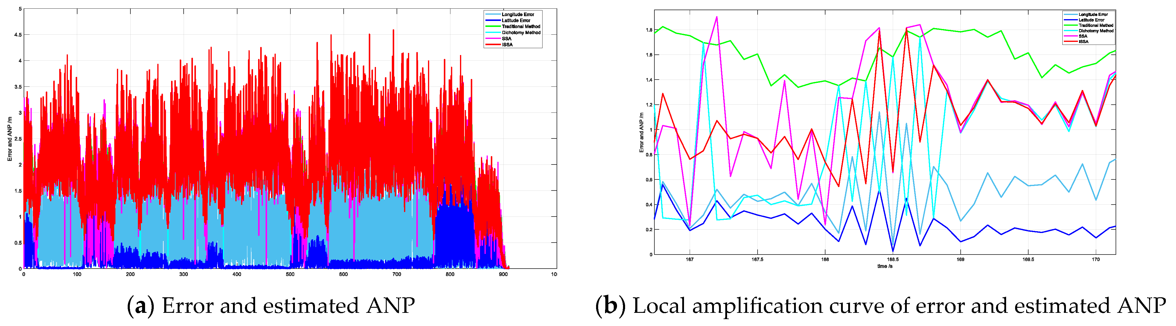
5.2. Results and Analysis

In the flight process of rotorcraft logistics UAVs, the optimization needs to be searched at each instant. The duration of this experiment was 910 s; the sampling frequency was 10 Hz. A convergence curve of the fitness function is generated for each iteration. To facilitate the evaluation of the algorithm’s performance, the average convergence curve of the fitness function over the 9100 optimization iterations is calculated, with the results presented in Figure 7.
The ordinate is the loss function value, which corresponds to Equation (10); that is, the smaller the value obtained by Equation (10), the more accurate the ANP value estimation, and the faster the convergence speed, the faster the ANP value is obtained. As shown in Figure 7, the SSA algorithm converges slowly and can easily converge prematurely. Our proposed ISSA algorithm not only converges faster but also achieves optimal convergence precision, indicating that it can enhance optimization accuracy and accelerate convergence speed. The results of ANP estimation using different methods are shown in Figure 8.
As shown in Figure 8a, the ANP obtained by traditional methods is generally overestimated, indicating poor navigation performance assessment. The ANP derived from the dichotomy method can be less than the latitude and longitude errors, which is entirely inconsistent with the definition of ANP. In contrast, our proposed ISSA method estimates the ANP closely aligned with variations in latitude and longitude errors, effectively capturing the error characteristics of the navigation system and enhancing the reliability of the UAV’s actual navigation performance assessment. We utilize the probability of the UAV’s actual position falling within the error circle to evaluate the performance of different methods, as shown in Figure 9.
The ordinate in Figure 9 is the probability that the actual position of the UAV falls into the error circle, and its specific meaning can be combined with the coverage area of the green part and the orange circle part in Figure 3. The closer the value is to 95%, the better the ANP estimation is. According to Figure 9a, the probabilities of the UAV’s actual position falling within the error circle by the traditional methods, the dichotomy, and the SSA method show significant fluctuations. In contrast, the probabilities from the proposed ISSA method are centered around 95% with smaller fluctuations, indicating that the ISSA method can effectively estimate the ANP of rotorcraft logistics UAVs. We adopt the mean value of probability and RMSE as evaluation metrics; the performance of different methods is shown in Table 3.
The probability mean is calculated and obtained by averaging according to the probability result in Figure 10. The average equation is as follows
Q ¯ = 1 N i = 1 N Q i
where Q i is the estimated error circle probability value at time i. N is the length of the sequence.
RMSE is also calculated according to Figure 10. The equation of RMSE is as follows
R M S E Q = i = 1 N Q i 0.95 N
As shown in Table 3, the ANP values estimated by the dichotomy method cannot reach the defined 95% error probability, while the SSA method performs better than the former one, indicating that the optimization algorithm for obtaining ANP values is superior to the traditional dichotomy method. Although the mean probability of the traditional methods is around 95%, Figure 9 shows that the error probabilities corresponding to the ANP values estimated by the traditional methods mostly exceed 95%. The upper and lower bounds of the traditional method are all over 95%, and the variance is large, while the upper and lower bounds of the proposed ISSA method are all around 95%, and the variance is extremely small, which has good stability. Our proposed ISSA method effectively meets the 95% error probability requirement with the smallest RMSE, demonstrating that the method can reliably and stably estimate ANP values, providing an effective reference for navigation alarms.
We employ a combination of experimental methods using the Monte Carlo analysis and the simulation method at any given time to obtain a scatter plot, comparing horizontal position errors and ANP values, as shown in Figure 10.
The specific meaning of the peripheral circle and the blue scatter in the figure can be combined with the coverage area of the green part and the orange part in Figure 3. When the coverage area between the peripheral circle and the blue scatter is closer to 95%, it shows that the ANP estimates better. As shown in Figure 10, the probabilities of the UAV’s actual position falling within the error circle are, respectively, 76.35%, 76.33%, 93.52%, and 94.99%, with the ANP values obtained by traditional methods, the dichotomy, SSA, and ISSA. Only our proposed ISSA method estimated an ANP value that meets the error probability requirements. It sufficiently verifies that the method proposed in this paper is efficient and highly accurate, effectively assessing the navigation system’s performance and enabling onboard performance monitoring and alerts.
This experiment was carried out in MATLAB R2022a with Inter® AMD Ryzen 7 8745H with the main frequency of 2.6 GHz, and the one-step solution time was used as the evaluation index. The results are shown in Table 4.
As can be seen from Table 4, the solution time of the traditional method is short, but the accuracy of ANP estimation cannot meet the error probability of 95%. The solution time of the proposed ISSA method can be guaranteed within 9 ms, which basically meets the real-time requirements of practical application and effectively improves the accuracy of ANP estimation.

6. Conclusions

In this paper, we conduct research on how to evaluate the ANP of rotorcraft logistics UAVs rapidly and accurately in urban environments. A real-time ANP estimation model is constructed based on the relationship between ANP and the probability of the UAV’s actual position within the error circle. The ISSA has been proposed to optimize the fitness function with ANP, the optimization objective, enabling the effective real-time estimation of ANP, thereby enhancing the assessment of the navigation system’s performance and ensuring the UAV’s safe flight.
(1)
The experimental results validate the accuracy and feasibility of the proposed real-time ANP estimation model.
(2)
In urban environments, the proposed ISSA can accurately estimate ANP, with its precision surpassing that of traditional methods, the dichotomy and SSA, demonstrating that ISSA improves the optimization capability of the algorithm. The estimated ANP value corresponds to a probability of 94.99% for the UAV’s actual position falling within the error circle, meeting the PBN operational requirements.
Our future objective is to establish navigation regulations for rotorcraft logistics UAV route operations in urban environments. Exploring the performance evaluation method of multi-UAV cooperative navigation to meet the needs of large-scale logistics distribution. Study the integration of UAV navigation systems with other urban traffic management systems to achieve more efficient urban logistics management and traffic coordination.

Author Contributions

Conceptualization, F.L.; Methodology, F.L.; Investigation, M.W. (Meiliwen Wu); Resources, L.Z.; Data curation, L.Z.; Writing—original draft, F.L.; Writing—review & editing, M.W. (Maolin Wang); Project administration, M.W. (Maolin Wang); Funding acquisition, F.L. All authors have read and agreed to the published version of the manuscript.

Funding

This research was funded by the Civil Aviation Safety Capacity Building Project of China (grant number [2023]B9) and Research Foundation for Youth Scholars of Civil Aviation Management Institute of China (Grant Number: KYXM20246706CW).

Data Availability Statement

The original contributions presented in the study are included in the article, further inquiries can be directed to the corresponding author.

Conflicts of Interest

Author Liang Zhao was employed by the company Hangzhou Antwork Technology Co., Ltd. The remaining authors declare that the research was conducted in the absence of any commercial or financial relationships that could be construed as a potential conflict of interest.

References

  1. Tedeschi, P.; Al Nuaimi, F.A.; Awad, A.I.; Natalizio, E. Privacy-aware remote identification for unmanned aerial vehicles: Current solutions, potential threats, and future directions. IEEE Trans. Ind. Inform. 2023, 20, 1069–1080. [Google Scholar] [CrossRef]
  2. Errico, A.; Di Vito, V. Performance-based navigation (PBN) with continuous descent operations (CDO) for efficient approach over highly protected zones. In Proceedings of the 2017 24th Saint Petersburg International Conference on Integrated Navigation Systems (ICINS), St. Petersburg, Russia, 29–31 May 2017; pp. 1–8. [Google Scholar]
  3. Enayatollahi, F.; Atashgah, M.A.; Malaek, S.M.B.; Thulasiraman, P. PBN-based time-optimal terminal air traffic control using cellular automata. IEEE Trans. Aerosp. Electron. Syst. 2021, 57, 1513–1523. [Google Scholar] [CrossRef]
  4. Ostroumov, I.V.; Kuzmenko, N.S. An area navigation (RNAV) system performance monitoring and alerting. In Proceedings of the 2018 IEEE First International Conference on System Analysis & Intelligent Computing (SAIC), Kyiv, Ukraine, 8–12 October 2018; pp. 1–4. [Google Scholar]
  5. Kallinen, V.; Martin, T.; McFadyen, A. Required navigation performance specifications for unmanned aircraft based on UTM flight trials. In Proceedings of the 2020 International Conference on Unmanned Aircraft Systems (ICUAS), Athens, Greece, 1–4 September 2020; pp. 196–203. [Google Scholar]
  6. Bechtel, R.; Narvid, J.; Graupmann, E. Enabling Established on Required Navigation Performance Usage to Reduce Carbon Emissions. In Proceedings of the 2023 IEEE/AIAA 42nd Digital Avionics Systems Conference (DASC), Barcelona, Spain, 1–5 October 2023; pp. 1–6. [Google Scholar]
  7. Dai, Y.; Lai, J.; Zhu, B.; Li, Z.; Sun, X.; Lv, P. Three-Dimensional ANP Evaluation Method Based on Spatial Position Uncertainty under RNP Operation. Aerospace 2022, 9, 703. [Google Scholar] [CrossRef]
  8. Wang, C.J.; Ng, E.M.; Low, K.H. Investigation and modeling of flight technical error (FTE) associated with UAS operating with and without pilot guidance. IEEE Trans. Veh. Technol. 2021, 70, 12389–12401. [Google Scholar] [CrossRef]
  9. Yao, X.; Zhang, X.; Huo, H. An Actual Navigation Performance Evaluation Method Based on Efficient Numerical Integration. J. Telem. Track. Command. 2016, 37, 26–31. (In Chinese) [Google Scholar]
  10. Zhang, N. Research on Calculation Method of Actual Navigation Performance. Aeronaut. Comput. Tech. 2017, 47, 49–51. (In Chinese) [Google Scholar]
  11. Ma, H.; Wang, D.; Sun, X. DR/GPS/DME/VOR Integrated Navigation and Performance Evaluation Methods Based on RNP Operation. Command. Control Simul. 2017, 39, 123–128. (In Chinese) [Google Scholar]
  12. Wang, D.; Ma, H.; Sun, X. Research on the Actual Navigation Performance Evaluating Method of Ground-based Area Navigation. Avion. Technol. 2019, 49, 13–18. (In Chinese) [Google Scholar]
  13. Dautermann, T.; Mollwitz, V.; Többen, H.H.; Altenscheidt, M.; Bürgers, S.; Bleeker, O.; Bock-Janning, S. Design, implementation and flight testing of advanced RNP to SBAS LPV approaches in Germany. Aerosp. Sci. Technol. 2015, 47, 280–290. [Google Scholar] [CrossRef]
  14. Džunda, M.; Melníková, L. The Influence of Narrowband Interference on DME System Operation. Aerospace 2023, 10, 663. [Google Scholar] [CrossRef]
  15. Peng, X.; Zu, Z.; Zhu, C.; Qi, M. Actual navigation performance evaluation algorithm of INS/GNSS navigation system. Electron. Test 2021, 3, 41–45. (In Chinese) [Google Scholar]
  16. Teng, J.; Zhu, L.; Ji, Y. Real-Time Evaluation Method of Flight Error Based on Actual Navigation Performance. Mod. Navig. 2022, 13, 92–96+101. (In Chinese) [Google Scholar]
  17. Wang, L.; Ren, Y.; Zheng, Z. Calculation Scheme of Actual Navigation Performance of Civil Aircraft Navigation System. Ind. Control Comput. 2022, 35, 74–76+80. (In Chinese) [Google Scholar]
  18. Li, W.; Wang, G.G.; Gandomi, A.H. A survey of learning-based intelligent optimization algorithms. Arch. Comput. Methods Eng. 2021, 28, 3781–3799. [Google Scholar] [CrossRef]
  19. Zhang, J.; Wang, X.; Lu, L.; Niu, P. Analysis and research of several new intelligent optimization algorithms. J. Front. Comput. Sci. Technol. 2022, 16, 88. [Google Scholar]
  20. Xue, J.; Shen, B. A novel swarm intelligence optimization approach: Sparrow search algorithm. Syst. Sci. Control Eng. 2020, 8, 22–34. [Google Scholar] [CrossRef]
  21. Xing, Z.; Yi, C.; Lin, J.; Zhou, Q. Multi-component fault diagnosis of wheelset-bearing using shift-invariant impulsive dictionary matching pursuit and sparrow search algorithm. Measurement 2021, 178, 109375. [Google Scholar] [CrossRef]
  22. Zhu, Y.; Yousefi, N. Optimal parameter identification of PEMFC stacks using adaptive sparrow search algorithm. Int. J. Hydrogen Energy 2021, 46, 9541–9552. [Google Scholar] [CrossRef]
  23. Li, L.L.; Xiong, J.L.; Tseng, M.L.; Yan, Z.; Lim, M.K. Using multi-objective sparrow search algorithm to establish active distribution network dynamic reconfiguration integrated optimization. Expert Syst. Appl. 2022, 193, 116445. [Google Scholar] [CrossRef]
Figure 1. Relationship between RNP and ANP.
Aerospace 12 00357 g001
Figure 2. ANP evaluation diagram.
Aerospace 12 00357 g002
Figure 3. Diagram of initial population strategy based on probabilistic decision-making.
Aerospace 12 00357 g003
Figure 4. The curve of Sigmoid function and adaptive dynamic step size.
Aerospace 12 00357 g004
Figure 5. Rotorcraft Logistics Unmanned Aerial Vehicles and Controller Structure of UAV.
Aerospace 12 00357 g005
Figure 6. UAV flight path.
Aerospace 12 00357 g006
Figure 7. Loss function curve.
Aerospace 12 00357 g007
Figure 8. The curve of error and estimated ANP.
Aerospace 12 00357 g008
Figure 9. The probability curve of the actual position of the UAV falling into the error circle.
Aerospace 12 00357 g009
Figure 10. Horizontal position error and ANP scatter plot.
Aerospace 12 00357 g010
Table 1. Comparison of Different Methods.
ReferencesCore IdeaMethod AdvantagesMethod Disadvantages
[9]Based on ICAO PBN requirements, ANP is solved by numerical integration method of Gauss three-point formula and complex Simpson formula.Efficient calculation to meet the real-time requirements of civil aircraftThe influence of dynamic environmental errors (such as meteorological disturbance) on integration accuracy is not considered.
[10]Aiming at the actual route, the dual mode of ANP approximation/accurate calculation is proposedAdapted to different precision demand scenarios, with strong practicability.The approximate calculation method has a large error in complex airspace structure.
[11,12]Real-time ANP evaluation based on position covariance matrixHigh-precision calculation, in line with RNP operating standards.Strong dependence on the accuracy of the sensor error covariance matrix.
[13]A new ANP computing architecture in multi-constellation GNSS environmentSupport multi-system integration scenarios such as GPS/GLONASS/BDS.The specific implementation details of the multi-constellation weight optimization algorithm are not disclosed.
[14]Special ANP calculation method for land-based navigation system (such as DME/VOR)Fill the blank of the performance evaluation of traditional navigation facilitiesThe mixed operation scenario with satellite-based navigation system is not considered.
[15]Real-time ANP estimation of inertial/satellite integrated navigation based on two-dimensional Gaussian distributionLow computational complexity, suitable for airborne embedded system implementation.It is only applicable to the performance evaluation of plane navigation and lacks vertical analysis.
[16]Realization of ANP dynamic verification framework on BlueSky simulation platformProvide a standardized verification environment to support the comparability research of algorithms.There are modeling errors between simulation environment and real flight data.
[17]Hybrid ANP computing scheme in multi-navigation mode (RNAV/RNP)Innovative Fusion Precision Factor, Error Covariance and Rayleigh DistributionThe transition algorithm for switching between different modes is not fully explained.
Table 2. Sensor parameters.
Sensor ParametersModelParameters
Gyroscope NoiseICM-20602±4 MdPS/Z Hz
Accelerometer Noise100 μg/Hz
GNSSVelocity ErrorNEO 3 GNSS Module0.05 m/s
GNSS Position Error2.0 m
Table 3. Probability means and RMSE.
MethodsTraditional MethodsDichotomySSAISSA
Metrics
Probability mean95.23%91.71%93.33%94.90%
RMSE0.21813.13881.58900.0915
Upper95.3476%91.9243%93.5977%94.9371%
Lower95.0985%91.4836%93.1369%94.8795%
Variance36.7496115.0108125.69751.9625
Table 4. One-step solution time of different methods.
MethodsTraditional MethodsDichotomySSAISSA
One-step solution time (ms)1.12743.75288.13888.7635
Disclaimer/Publisher’s Note: The statements, opinions and data contained in all publications are solely those of the individual author(s) and contributor(s) and not of MDPI and/or the editor(s). MDPI and/or the editor(s) disclaim responsibility for any injury to people or property resulting from any ideas, methods, instructions or products referred to in the content.

