Abstract
Groundwater contamination in the Mediterranean Basin is a severe problem that has a significant impact on environmental ecosystems and human health. The unconventional uranium and the potentially toxic elements (PTEs) of phosphate rocks are the principal contaminants in the phosphate mining industry in Tunisia. Phosphogypsum (PG) results from the valorization of phosphate to fertilizers and phosphoric acid. PG stocks can be used in cement production, brick manufacturing, and soil amendments in desertic land, and can be resolved by using nanomaterial adsorbents. In the flat area of the study area, the increase in radioactivity (40K) is due to abusive fertilizer use. Geochemical and radiological analyses in the northern part of Tunisia and its karst shallow aquifer indicate significant contamination levels. The northern part exhibits moderate contamination, whereas the karst shallow aquifer shows higher contamination levels, particularly with elevated nitrate concentrations. In the phosphate basin, both washing phosphate and phosphogypsum reveal high levels of radioactive elements, with the latter showing especially high concentrations of radium. The shallow aquifer in this region has moderate contamination levels, while the deep geothermal aquifer also shows noticeable contamination but to a lesser degree compared to the shallow aquifer. The shallow groundwater is characterized by a higher value of radioactivity than the groundwater due to the contamination impact from the phosphate industry and the cumulative radioactivity disintegration. Finally, the nanoparticles and the electrostatic adsorption can decrease the PTEs and radionuclides from the contaminated water in the study area. Moreover, other key issues for advancing research on groundwater contamination are proposed in this study. It is time to valorize this PG and the other mines of (Fe, Pb, and Zn) in the socioeconomic sector in Tunisia and to minimize the environmental impact of the industrial sector’s extraction on groundwater and human health in the study area.
1. Introduction
One-third of the global population depends on groundwater for drinking water [1,2,3]. In Tunisia, groundwater is a major source of fresh water for around 12 million people for domestic, agricultural, industrial, and tourism uses. However, urbanization, agricultural practices, industries, touristic activities, and climate change all pose significant threats to groundwater quantity and quality. Radionuclides, potentially toxic elements, organic and inorganic contaminants, pesticides, fertilizers, nanoparticles, hydrocarbon, microplastic, and other emerging contaminants, are threats to human health, environmental services, and sustainable socioeconomic development [4,5,6,7,8,9,10,11,12].
The geoscientific literature has discussed the potential health impacts of ionizing radiation emitted by radionuclides, which are components of naturally occurring radioactive materials. These radionuclides are often found in petroleum and gas products, as well as their by-products, including crude oil, scale, sludge, polluted water, and sand [13]. They are also prevalent in phosphate mining areas and processing facilities [14]. Naturally occurring radioactive materials radionuclides in phosphate mining areas can lead to both external and internal exposure to gamma radiation, as well as β and α particles emitted from 238U, 232Th, and their decay products, alongside 40K. Most radionuclides found in phosphate rocks are part of the 238U and 232Th natural decay series, in addition to K-40. This exposure poses a significant risk to human health, necessitating rigorous monitoring and management of these radioactive materials.
It is estimated that 20% of global aquifers are overexploited, leading to subsidence, saltwater intrusion, and increased treatment costs [15]. In addition, nitrate, phosphate, sulfate, fertilizers, pesticides, heavy metals, and radionuclides in air, soil, and bedrock enter groundwater by surface runoff, erosion, desorption, and dissolution. Radionuclides and PTEs from phosphate rocks and phosphate/stock from other mines are transported by wind and seep into groundwater [16].
However, widespread pollution and increasing dependence on groundwater have resulted in a decline in quality and quantity. Groundwater reserves in the majority of the world’s basins are depleting at a rapid rate, such as in North Africa (Morocco, Algeria and Tunisia) (20 mm-8m/y), Libya (25 mm-4m/y), Egypt (45 mm-10m/y), the Middle East (Saudia Arabia = 50 mm-6m/y), Iraq (20 mm-10m/y) northwestern India (40 mm/y), North China (22 mm/y), and the high plains of the USA (27.6 mm/y) [17,18,19,20,21,22,23,24,25,26,27].
In the study area, the phosphatic rock extraction started in the mid-1950s after the phosphate mine was discovered in 1899 in the Gafsa basin (Metlaoui region–Thelja Gorge) by the Company of Phosphate of Gafsa (CPG). The annual production of exported phosphate varied from 6 to 9 million tons, placing Tunisia fifth among world phosphate producers before 2010 [28,29]. The Tunisian area (Gafsa-El Kef basin) is one of the most productive phosphate regions in North Africa; it is ranked as the third country in phosphate production (phosphate, phosphoric acid, and fertilizers) during this period. In this report, we study the impact of the phosphate industry on the environment and human health in the study area.
2. Study Area
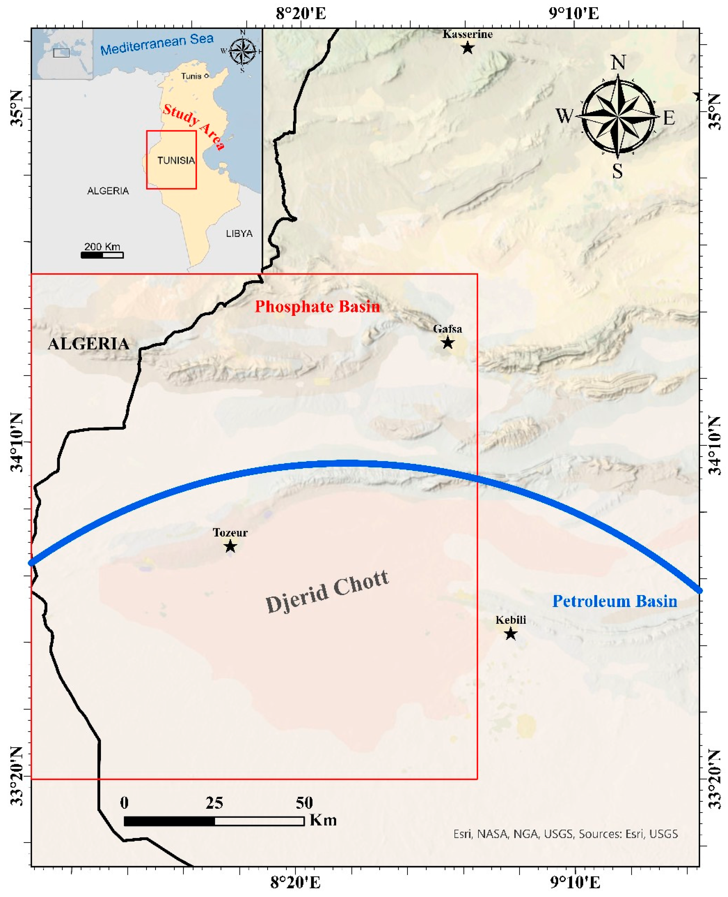
In the study area, the precipitation and surface water are limited due to the arid climate of North Africa. Groundwater is a particularly important resource in this arid and semi-arid land. The study area is located in the southern Mediterranean Basin, North Africa. It is limited to the north and the east by the Mediterranean Sea, to the west by the Algerian territory (Atlas Monts of North Africa), and to the south by the Saharan platform (Figure 1). The great desert of North Africa (Algeria, Tunisia, and Libya) is characterized by climatic fluctuation and irregularity with a precipitation rate varying between 50 mm/y and 1500 mm/y. The climatic and meteorological parameters vary from the north to the south. The north is characterized by (1000 < P < 1500 mm/y; −5 < T < 20 °C; 1000 < ETP < 1200 mm/y and 865 < solar radiation < 1045 Kwh/m2/y). However, the south is characterized by (50 < P < 350 mm/y; −10 < T < 45 °C; 1750 < ETP < 2500 mm/y and 870 < solar radiation < 1075 Kwh/m2/y). The study area is characterized by an arid to semi-arid climate in the northern part of North Africa–Southern Mediterranean Basin [15,28].
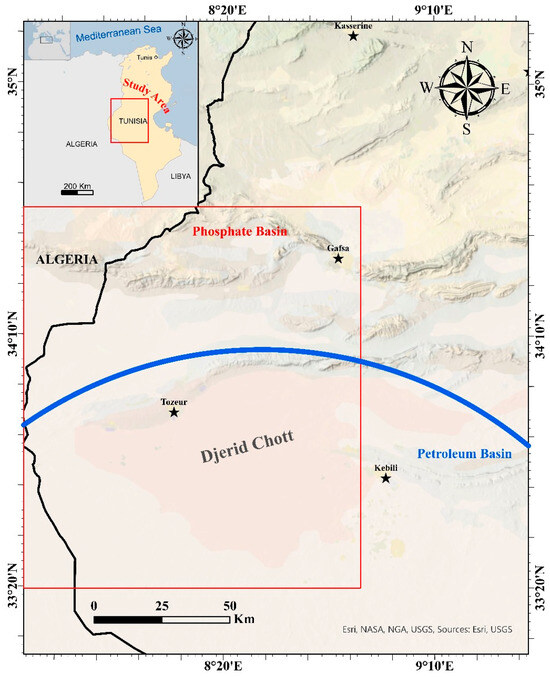
Figure 1.
Geographic location of the study area.
3. Socioeconomic of the Study Area
Tunisia’s economy has long been heavily dependent on extracting and exporting phosphate resources. In addition, the country’s petroleum industry plays a significant role in contributing to its gross domestic product (GDP), (Figure 1). Many of Tunisia’s social and economic activities, as well as the development of important cities like Gabès and Gafsa, are deeply intertwined with these extractive industries. The phosphate ore mines that are exploited in Tunisia are primarily located in the southwestern regions of the country. This geographical concentration of phosphate resources has been a key factor in shaping the economic landscape and regional development patterns. During the last half-century, anthropogenic activities increased to boost the Tunisian economy. These Eocene (Ypresian) rocks (47 to 55 million years) are very rich in uranium and some other rare elements (toxic and non-toxic: Cd, F, Li, Cr, Cu, As, Pb, Zn, Fe, Sr, Sb, V, and Eu) [9,10,11,30]. The uranium content in this rock depends on climatic, tectonic, and eustatic paleo conditions. The uranium distribution in the different phosphate layers in the study area provides information about the sedimentation and oxidoreduction conditions, and the determination of the activity ratios of 234U/238U in the phosphate layers can give information about the paleoclimatic and paleogeomorphology conditions. The natural radionuclide uranium has three isotopes in the natural environment U-234 (0.0054%), U-235 (0.72%), and U-238 (99.27%) [31]. Of these isotopes, U-238 is the most important natural radionuclide due to its long half-life (4.5 × 10⁶ years) and chemical and radiation toxicities [32,33].
4. Lithological Proprieties
Based on data from cores collected from different stations in the study area (Table 1 and Table 2). In the north part of the study area (Table 1), we could distinguish two different lithological levels [5,6,7]:

Table 1.
Characteristics of the lithological levels of the study area (north of Tunisia).
Table 2.
Characteristics of the lithological levels of the study area (south of Tunisia).
- 1-
- Alluvial sands and gravel (riverbed) are characterized by homogeneous fine-to-medium sands intercalated by laminates of silts, with a predominance of silt and clay (approximately between 60 and 66%), and a thickness of 0.5 to 2.5 m;
- 2-
- Limestones are characterized by carbonate and dolomite (fractured and karstified rocks) with a thickness of 2 to 50 m.
In the southern part of the study area (Table 2), we could distinguish two different lithological levels [34]:
- 1-
- Aeolian deposits are mainly composed of fine–medium-grained sands, with a predominance of silts (55–65%) and clays (15%), and have a low level of organic matter. They have a variable thickness from one region to another, ranging from 0.5 to 2 m. Over the last ten years, this thickness has increased year by year, essentially due to the phenomenon of continuous desertification driven by sandstorms from south to north;
- 2-
- Alluvial sands (riverbeds) are characterized by homogeneous fine-to-medium sands intercalated by laminates of silts, with a predominance of silts (62–64%) and clays (approximately 16%), with a thickness ranging from 2 to 3 m.
5. Hydrology and Hydrogeology Setting
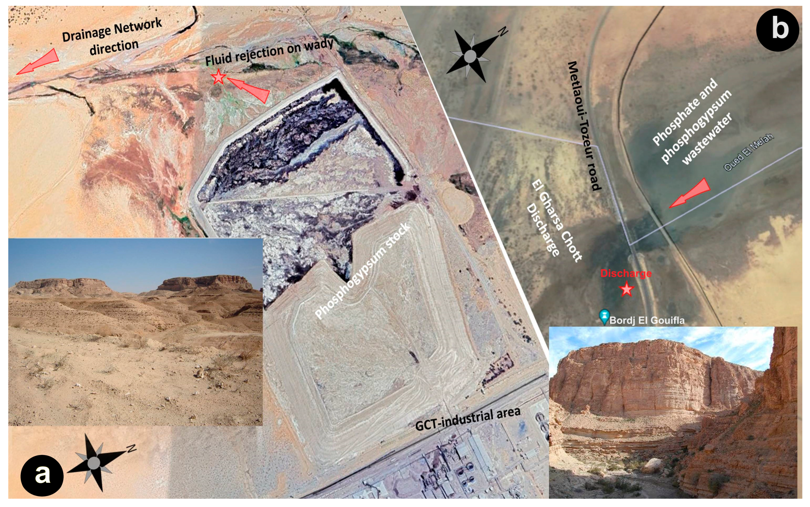
In the north, the Majerda drainage network is dendritic and perennial due to the natural recharge (precipitation and springs) and anthropogenic activities (wastewaters from the Fe, Pb, and Zn mines). In the southern part, the study area is characterized by non-perennial wadies due to the arid climate, but the industrial sector (washing phosphate and phosphogypsum valorization) creates a new stage by discharging wastewater directly into the drainage network. This situation causes groundwater contamination through the alluvial deposits and the major faults. The hydrogeology part is based on data from the lithostratigraphic data from piezometers and exploitation boreholes from the multi-aquifer system in the study area (10 < depth < 2150 m) (Figure 2). Several aquifer horizons can be distinguished in the study area [11,23]:
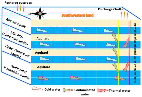
Figure 2.
A mathematical conceptual model showing the hydrodynamic of the multi-aquifer system in the southern part of the study area.
- 1-
- Alluvial aquifer, Pliocene, and Pleistocene–Holocene sands (shallow aquifer);
- 2-
- Mio-Plio-Quaternary aquifer (semi-confined aquifer);
- 3-
- Upper Cretaceous limestone/dolomite (semi-confined aquifer);
- 4-
- Lower Cretaceous sand (confined aquifer), contains fossil water (40–45 million years) and geothermal water (35–92 °C).
The groundwater contained in these aquifers is mainly recharged by precipitation and perennial drainage networks. Numerous hydraulic exchanges take place in these layers and directly influence the hydrogeological conditions, ensuring their hydraulic intercommunications (major faults impact).
6. Material and Methods
During spring, summer, and autumn 2023, 105 sediment samples, 50 air locations, and 33 deep wells in this study were analyzed using a TERRA detector (pocket-type instrument) in the field, known for its high sensitivity to climatic variations such as temperature and humidity, as well as anthropogenic activities. This state-of-the-art detector is capable of accurately detecting and quantifying the cumulative levels of alpha and beta particles, as well as gamma rays, providing precise measurements of the diverse forms of total radioactivity (U-Th-Ra and R) present in the analyzed samples. It features high-resolution capabilities for sediment samples and includes a user-friendly display screen. The samples were further dried at 105 °C for 24 h to ensure the complete removal of moisture. Quality control (QC) procedures were applied using homemade control samples and reference samples provided by the IAEA (Environmental Monitoring Laboratory, Department of Energy, Ukraine). An IAEA reference multi-standard radionuclide source was utilized to calibrate the energy and efficiency of the detector. The sediment sampling was based on the collection of sediment cores at depths of up to 2 m and cutting was conducted every 10 cm for physicochemical and radiometric analyses. The groundwater wells are based on data sampling from the exploitation boreholes in the study area.
The starting materials were washed with distilled water, dried at 110 °C overnight, and sieved to give a homogeneous sample, and we followed the international protocol in this geochemical analysis in the LAM3E laboratory, Chemistry Department, Faculty of Sciences of Gafsa, Tunisia, and the radio-analysis laboratory of Bizerte Faculty, Tunisia. Analyses were performed with a broad-energy germanium detector (Canberra), with a relative efficiency of 43 percent. The U-238 activity was determined using four gamma peaks of Bi-214 and two peaks of Pb-214 and Rn-222. U-235 was determined using the photopeak at 143 KeV, and Th-232 was determined by the 911 KeV peak of Ac-228. Calibration of the detection system was performed using a certified multi-gamma source and was controlled using reference materials from the International Atomic Energy Agency (AIEA), IAEA 327, and IAEA 375.
7. Radiochemical Determination Methods
7.1. Determination of Po and Th
The sample solution passed through the TEVA columns, which were conditioned with 10 mL of 3 M HNO3. The columns were rinsed with 6 mL 3 M HNO3. These effluents were retained as U portions and evaporated to dryness; 20 mL of 8 M HNO3 was used to elute polonium. After this, the thorium was eluted with 20 mL of 10 M HCl. The Po portion solution was retained for the following micro-co-precipitation, and the Th solution was evaporated to dryness. For radioactivity analysis, Po and Th alpha sources were prepared via the CuS micro-co-precipitation method and counted using alpha spectrometry for 24 h.
7.2. Determination of U
The UTEVA columns were pre-conditioned with 15 mL of 8 M HNO3, and the dried U samples were dissolved in 8 M HNO3. The sample solutions were loaded into UTEVA columns and rinsed with 15 mL of 8 M HNO3. Next, the columns were washed with 15 mL of 4 M HCl, converting the columns to chloride form and removing any residual thorium or plutonium. After this, the U was eluted with 20 mL of 0.5 M HCl; then, 1 mL of 10% sodium sulfate Na2SO4 and 5 mL of concentrated HNO3 were added. The solution was then evaporated to dryness. The U alpha source was obtained using the NdF3 micro-co-precipitation method, and radioactivity was measured via alpha spectrometry [35].
7.3. Radioactivity Measurements of Ra
Groundwater was used directly without chemical separation for the determination of Ra isotopes by gamma spectroscopy. Before gamma counting, groundwater samples were stored for a few weeks, reaching a complete equilibrium between radium and radon. Approximately 2.5 L of sample aliquot was sealed in a sample container and was counted in a high-purity germanium detector for 48 h, a long enough time to minimize the counting errors. In the direct approach, 226Ra was determined by measuring the peak at 186.2 keV. The radioactivity of 228Ra was obtained by counting its daughter 228Ac (t1/2 = 6.15 h) [36].
8. Results and Discussions
8.1. Radionuclides Transfer Mode and Environmental Impact
8.1.1. Environmental Contamination Measurements
Extensive measurements were conducted using in situ gamma spectrometry techniques to accurately estimate the inventories of radionuclides in contaminated soils and groundwaters within the study area. This approach is an efficient alternative to the traditional, time-consuming methods of air, soil, and groundwater sampling followed by laboratory analysis. The surface gamma spectrometry investigation depth ranged from 0.2 to 2.5 m, depending on the specific soils and radionuclides under consideration.
8.1.2. Gamma Spectrometry Data
The gamma spectrometry data provided detailed insights into the spatial distribution of radionuclides within the study area. The results revealed significant variability in radionuclide concentrations across different sites. The specific radionuclides measured included uranium (U), thorium (Th), and radium (Ra); the average concentrations are detailed in Table 1.
8.1.3. Mathematical Modeling of Radionuclide Transport
To further understand the transport and distribution of radionuclides, we adopted mathematical models for solute transport in groundwater, as developed by references [23,37,38,39,40,41,42]. These models are essential for demonstrating the system’s functioning in a steady state, particularly concerning the flow speed and the transport of radionuclides in the unsaturated zone. This transport is influenced by artificial recharge from phosphate wastewater, phosphogypsum (PG), and other mining fluids within the multi-layer aquifer system.
8.1.4. Modeling Approach and Findings
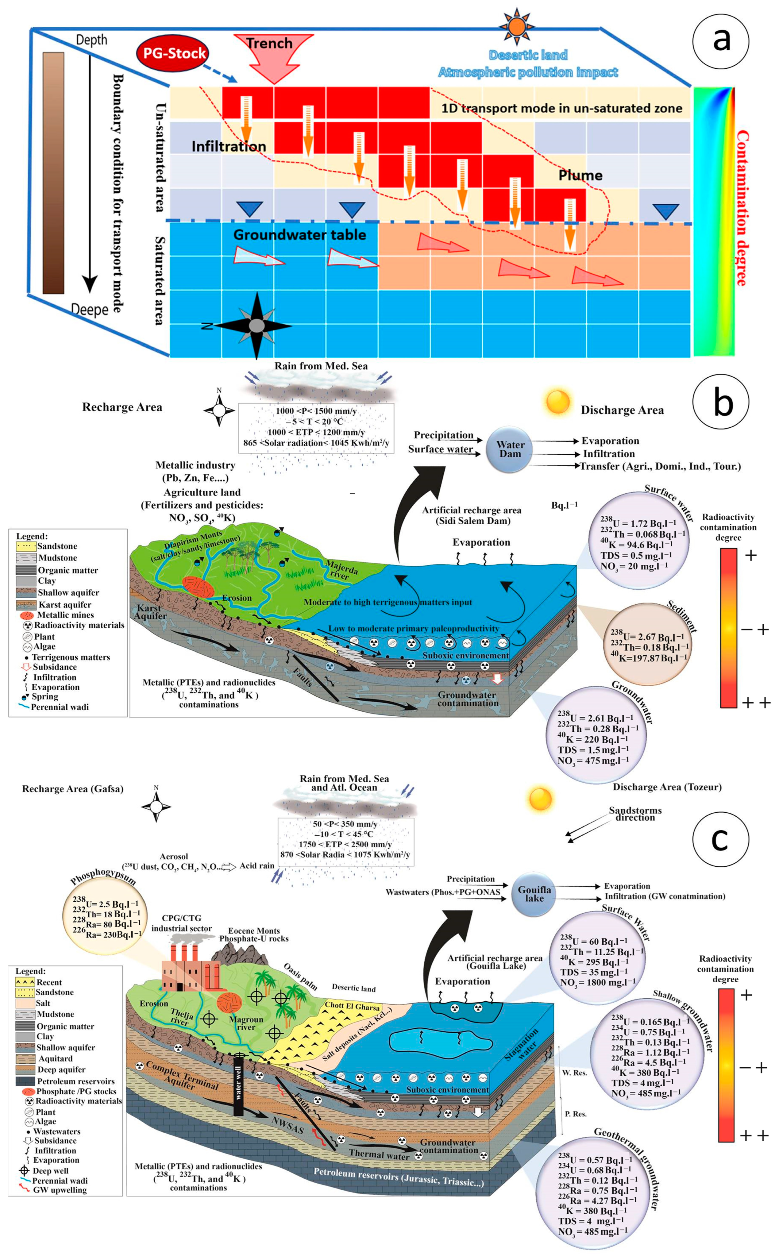
The transfer of radionuclides was modeled under the assumption that the medium is laterally isotropic and homogeneous, and vertically anisotropic and heterogeneous. The solute transfer occurs primarily through mass effect. Initially, a coupled 1D and saturated 3D model was explored to simplify the unsaturated model. However, due to the inconclusive nature of the unsaturated 1D approach, an unsaturated 2D model was subsequently constructed to provide a more realistic representation of groundwater flow and radionuclide migration. The results of this modeling are shown in Figure 3 and Figure 4a.
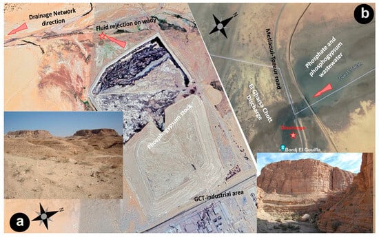
Figure 3.
The origin of groundwater contamination in southwestern Tunisia (a) in the wadi; (b) in the Sebkha.
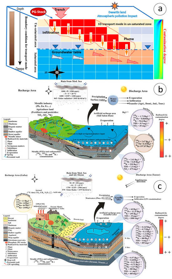
Figure 4.
(a) Model of radionuclide propagation through groundwater transfer in southwestern Tunisia. (b) The conceptual model shows the dam surface water and karst groundwater contamination in northern Tunisia. (c) The conceptual model shows the dam surface water and karst groundwater contamination in northern Tunisia [12].
8.1.5. Radionuclide Distribution Patterns
Figure 3 and Figure 4a illustrate the spatial variability in radionuclide distribution and the predicted flow patterns of groundwater. The data indicate that radionuclide concentrations are higher in areas closer to mining activities and artificial recharge points. This spatial distribution highlights the significant impact of anthropogenic activities on environmental contamination levels.
8.1.6. Health and Ecological Risk Assessment
A preliminary health and ecological risk assessment was conducted based on the measured and modeled radionuclide concentrations. The assessment identified potential risks to human health and the ecosystem, particularly in areas with elevated radionuclide levels. These findings underscore the importance of continuous monitoring and the implementation of mitigation strategies to protect public health and the environment.
The deterioration of the ecosystem and human health is in relation to the water resources contamination by the phosphate extraction in the study area. The rate of gamma radioactivity in the deep groundwater ranges between 0.07 and 0.31 mSv/y, and this water contains higher radioactivity compared to shallow groundwater (Table 3). The increasing radioactivity in shallow wells is due to the direct contamination by dust aerosols (atmospheric pollution) and soil (pedological pollution) from phosphate-U extraction and phosphogypsum-U solid stock in the M’dhila region. But far from this region (Gafsa North, Sidi Boubaker, and Oum Laksab), this water is not contaminated. The increasing radioactivity in deep groundwater of the CI transboundary aquifer (thermal fossil deep groundwater from the North-Western Sahara Aquifer System) is due to the water–rock interaction and the dissolution impact of the radionuclides in the aquifer (long residence time). The concentration of all the samples measured is higher than the guidance level (1 Bq/L) for controlling radionuclide health risks from drinking water, as proposed by the WHO The high concentrations of radioactivity have been found near the industrial area (phosphate-U of the Gafsa basin), in the deep geothermal water in the Tozeur region (GWs 18, 19, 20), and the deep geothermal water in the Sidi Ahmed Zarroug region (GW 17- Gafsa region). In the shallow aquifers, the radionuclide concentrations are U-238 = 0.165 Bq/L, U-234 = 0.75 Bq/L, Th-228= 0.12 Bq/L, Ra-228 = 1.12 Bq/L, and Ra = 4.5 Bq/L. Nevertheless, these concentrations in the deep aquifers are U-238 = 0.57 Bq/L, U-234 = 0.68 Bq/L, Th-228 = 0.12 Bq/L, Ra-228 = 0.75 Bq/L, and Ra = 4.27 Bq/L (Table 3).
Table 3.
Concentrations 238U, 228Th, 226 Ra (Bq/L) and gamma radioactivity (mSv/y) in shallow and deep groundwater samples in southern Tunisia.
Adding contributions from all radionuclides present in the study area, the total annual effective dose HE (mSvy−1) to an individual was found for the studied samples using Equation (1):
HE = ∑(Ra × Ai · Cf)
Ra is the radioactivity concentration of radionuclides in the water samples (BqL−1), Ai is the annual intake (1y−1), and Cf is the ingested dose conversion factor for radionuclides (mSvy−1), which varies with the type of radionuclide, as well as the age and gender of the individuals ingesting the toxic radionuclides.
8.2. Groundwater Contamination
Groundwater contamination poses significant risks to the ecosystem, human health, environmental quality, and socioeconomic development in the study area. Our study focused on the transboundary region of the Tuniso-Algerian basin, examining both the northern and southern parts of this area.
8.2.1. Northern Transboundary Part (Tuniso-Algerian Basin)
In the northern part of the basin, the shallow karst aquifers are particularly vulnerable to surface contamination from perennial drainage networks and agricultural activities. The use of surface water from dams and irrigation with water from shallow aquifers, both contaminated with potentially toxic elements and radionuclides, can lead to the accumulation of these toxic elements in crops such as cereals and vegetables, posing direct health risks to humans.
The geochemical and radiological analyses revealed the following concentrations in surface water from the Sidi Salem Dam:
238U: 1.72 Bq/L, 232Th: 0.068 Bq/L, 40K: 94.6 Bq/L, TDS: 0.5 mg/L and NO3: 20 mg/L.
In contrast, the shallow karst aquifer exhibited higher contamination levels:
238U: 2.61 Bq/L, 232Th: 0.28 Bq/L, 40K: 220 Bq/L, TDS: 1.5 mg/L and NO3: 475 mg/L.
These findings indicate that groundwater has higher radioactivity levels compared to surface water, likely due to cumulative effects and radioactive decay. The excessive use of fertilizers and pesticides in agricultural areas contributes to elevated nitrate levels (NO3 = 475 mg/L) and potassium-40 (40K = 220 Bq/L).
Our conceptual model, which integrates geological, hydrological, hydrogeological, geochemical, and radiological data, illustrates the relationship between surface water and groundwater in the study area (Figure 4b).
8.2.2. Southern Transboundary Part (Tuniso-Algerian Basin)
In the southern part of the basin, the shallow and deep aquifers, including the Complex Terminal and North-Western Sahara Aquifer System, are also susceptible to surface contamination from perennial drainage networks such as the Thelja and Magroun wadis. Contamination in these areas arises from domestic use and irrigation with water from shallow and deep aquifers containing potentially toxic elements and radionuclides. These contaminants accumulate in fruits (e.g., dates, pistachios, olives) and vegetables, increasing health risks to humans.
A major source of contamination in this region is the phosphate–uranium rock extraction industry in the Gafsa industrial sectors. Activities such as extraction, washing, and processing into phosphogypsum, fertilizers, and phosphoric acid contribute to atmospheric, pedologic, hydrologic, and hydrogeologic pollution.
The geochemical and radiological analyses from washing phosphate show 238U = 60 Bq/L, 232Th = 11.25 Bq/L, 40K = 180 Bq/L, TDS = 2100 mg/L, and NO3 = 524 mg/L; from PG, the measurements are 238U = 2.5 Bq/L, 232Th = 18 Bq/L, 228Ra = 80 Bq/L, 226Ra = 230 Bq/L. Shallow groundwater shows 238U = 0.165 Bq/L, 234U = 0.75 Bq/L, 232Th = 0.13 Bq/L, 228Ra = 1.12 Bq/L, 226Ra = 4.5 Bq/L, 40k = 380 Bq/L, TDS = 4 g/L and NO3 = 485 mg/L. Deep geothermal aquifer results are 238U = 0.57 Bq/L, 234U = 0.68 Bq/L, 232Th = 0.12 Bq/L, 228Ra = 0.75 Bq/L, 226Ra = 4.27 Bq/L, 40k = 380 Bq/L, TDS = 4 g/L and NO3 = 485 mg/L. The shallow groundwater is characterized by a higher value of radioactivity than the groundwater from the contamination impact from the phosphate industry and the cumulative and radioactivity disintegration impacts. The excessive use of fertilizers and pesticides in agricultural areas causes an increase in NO3 (485 m/L) and 40K (380 Bq/L). The following conceptual model refers to the combination of all the geological, hydrological, hydrogeological, geochemical, and radiological data showing the relationship between the surface water and the groundwater in the study area (Figure 4c). The artificial lake of the Gouilfa area is characterized by the stagnation of surface wastewater from washing phosphate, phosphogypsum stock, and human wastewater (ONAS). In this place, we detected a high rate of gamma radioactivity and a high value of organic matter. The transfer of this contaminated water to the deep groundwater caused the deterioration of the deep groundwater used in the domestic and irrigation sectors in the study area.
Uranium is a radiotoxic and chemotoxic element with an average abundance of 2.7 mg/kg in the Earth’s crust. It generally occurs in minerals such as carnotite, uraninite, and autunite in rocks and ores. Uranium concentrations as high as 15 mg/kg and 120 mg/kg are found in volcanic rock (granite) and phosphate rock, respectively [43]. Uranium is 500 times more abundant than gold, and 40 times more than silver [44]. There are three naturally occurring radioactive isotopes of uranium: (238U-99.27%, t1/2 = 4.468 × 10⁹ years), (235U-0.711%, t1/2 = 7 × 10⁸ years), and (234U-0.005%, t1/2 = 24.5 × 10⁴ years).
The radiotoxicity transfer from sediments to water resources in the study area depends on the pH, Eh, and the form of the father radionuclides (238U). Uranium exists in various natural oxidation states, such as +3, +4, +5, and +6. In an aquatic environment, the predominate states of uranium are tetravalent (U-IV) and hexavalent (U-VI), with the chemical forms UO2 (uranous oxide) and UO22+ (uranyl ion), respectively. U-IV is sparsely soluble (10–6 m/kg at 25 °C) and immobile, whereas (U-VI) is soluble in water, mobile, and toxic to the ecosystem and the environment [45,46]. In nature, other soluble forms of uranium are UO2F2, UO2 (NO3)2, UO2Cl2, UF6, uranyl acetates, uranyl sulfates, and uranyl carbonates [47]. However, oxidation-reduction and geochemical processes like mineral dissolution and desorption from uranium-hosting minerals (Fe-Mn (oxy/hydroxides), silicates, and phosphate rocks) are mainly responsible for uranium release in groundwater [48]. High uranium concentrations in deep groundwater are predominantly due to U-VI species that leach from host rocks under oxic to suboxic conditions [49]. This radionuclide can be redeposited onto sandstone (Complex Terminal “Segui and Beglia sandy Fms.” and NWSAS “Sidi Aich sandy Fm.”) under reducing environments. The geothermal deep water of NWSAS can be a good catalyst of uranium mineral dissolution but the clay mineral and the organic matter of the aquitards in the study area can be the inhibitors of radioactivity propagation in groundwater depending on their thickness [12]. In this sandy geothermal transboundary aquifer, the uranium is favorably fractionated in high-temperature meta-luminous melts and is dependent on the geothermal gradient (30 °C/Km). The continental sandstone of the Sidi Aich Fm. of NWSAS is radiologically stratified by these radionuclides. These radiological groundwater contaminations are observed in many regions of the world like the USA, the Republic of Korea, Australia, Brazil, Pakistan, Switzerland, Finland, Egypt, Algeria, Morocco, KSA, and Kuwait [28,50,51,52,53,54,55].
8.3. Human Health Impacts
Fertilizers and pesticides used in agricultural areas can increase groundwater contamination. Nitrogen contaminants, such as nitrate, nitrite, and ammonia nitrogen, are prevalent inorganic contaminants. Nitrate is predominantly from anthropogenic sources, including agriculture and domestic wastewater [12,56,57,58]. Other potentially toxic and non-toxic elements found in groundwater include anions, oxyanions, and cations, such as Cd, Pb, Zn, Cr, F, SO4, Cl, Na, K, Ca, and Mg. Total dissolved solids (TDSs), which refer to the total amount of inorganic and organic ligands in water, also may be increased in groundwater (water–rock interactions). These contaminants are usually of natural origin, but human activities also can elevate concentrations in groundwater [59,60].
Potentially toxic elements (PTEs), metalloids, radionuclides (238U, 236Th, 224Ra, 222Ra, and 40K), and both natural and anthropogenic aerosols (particle dust, CO2, CH4, N2O…) are risk factors for the natural ecosystem and human health. Exposure to excessive concentrations of these PTEs can lead to severe poisoning, although some of these elements are essential micronutrients at lower doses [8,61]. For example, exposure to hexavalent chromium (Cr6+) can increase the risk of cancer [62]. Arsenic is ranked as a group 1 human carcinogen by the US Environmental Protection Agency (EPA) and the International Agency for Research on Cancer (IARC), and As3+ can react with the sulfhydryl (-SH) group of proteins and enzymes, upsetting cellular functions; these elements are persistent in the environment and are subject to moderate bioaccumulation when they enter the food chain [61,62].
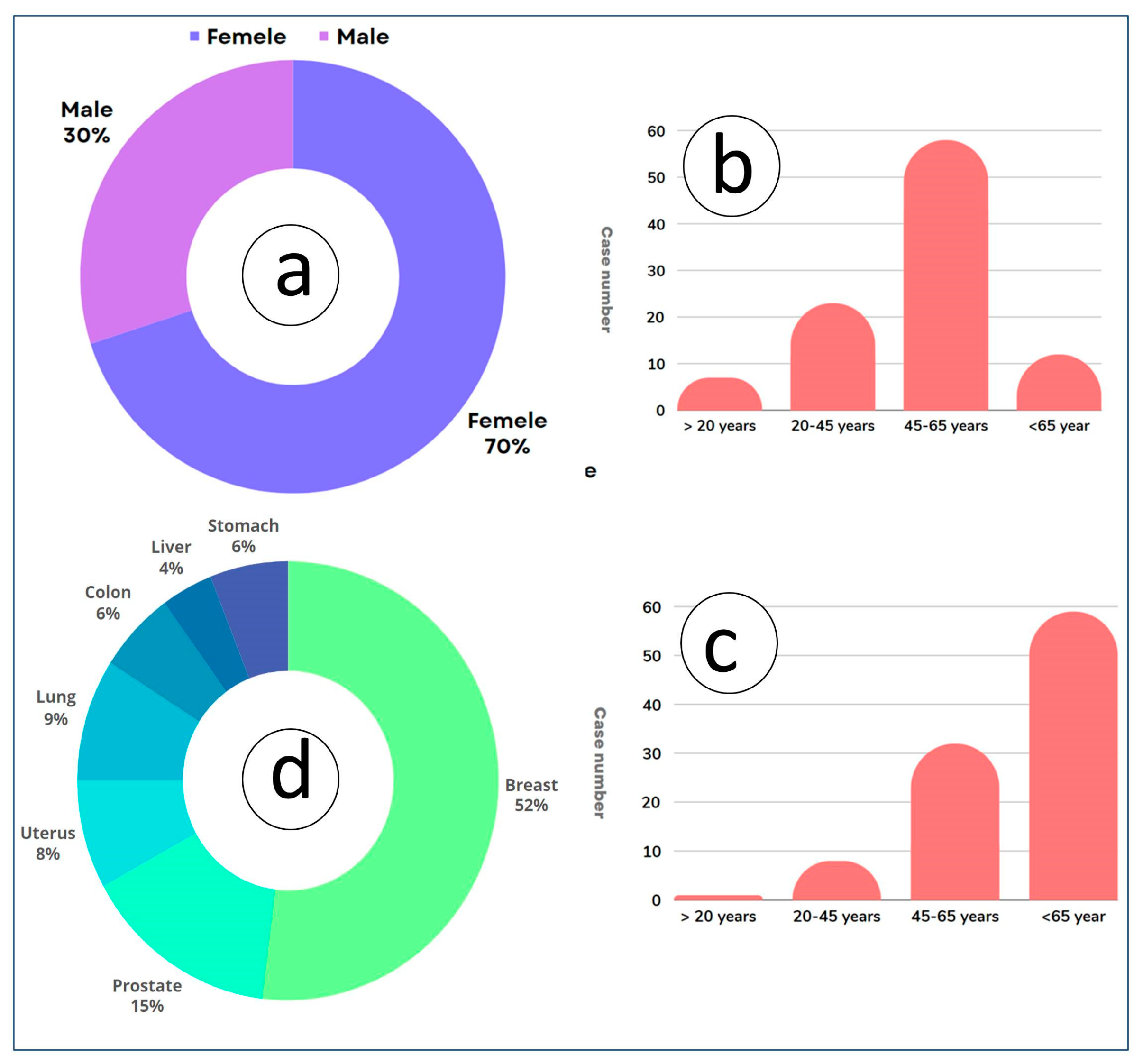
The questionnaire was administered considering variables such as gender, age, and residency status, distinguishing between inhabitants of mining regions and those living outside these areas (150 persons). The collected data were then analyzed to determine the prevalence of diseases, with results expressed as percentages for each demographic group and geographic location. This method allowed for a comprehensive assessment of how these factors influence health outcomes in both mining and non-mining communities. Males are affected at a rate of 30% with the most affected age group being over 65 years old. For females, the rate is 70%, with the most affected ages between 45 and 65 years old (Figure 5a–c). The different types of cancers in both sexes (male—30% and female—70%) are breast—52%; prostate—15%; lung—9%; uterus—8%; stomach and colon—6% each; and liver—4%) (Figure 5d).

Figure 5.
(a–c) Human health contamination vs. sex and age. (d) The different types of cancer in the study area.
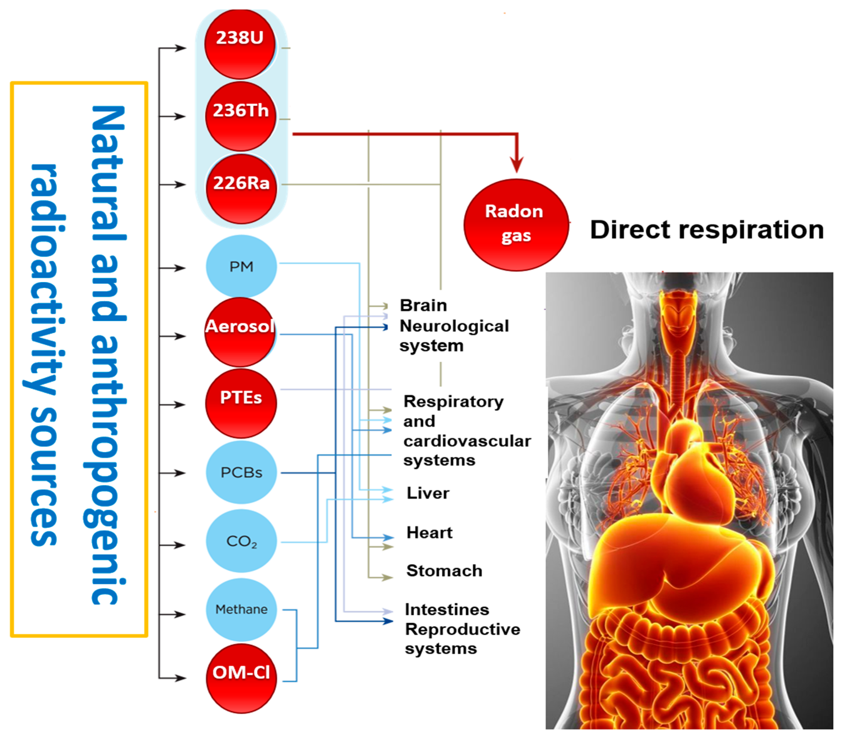
In the study area, the radioactivity impact on human health depends on the adsorption dose (cumulative dose/day and/or per year) from natural and anthropogenic radioactivity. High radiation can damage the DNA in our cells, as well as neurological, respiratory, and reproductive systems, leading to cancer (Figure 6).
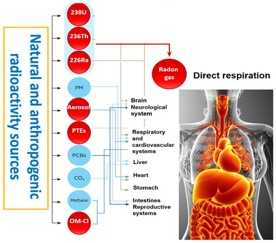
Figure 6.
Natural and anthropogenic radioactivity impacts on human health in the study area.
The study area suffers from radionuclide disintegration (238U, 236Th, 228Ra, 226Ra, and 222R), as well as the impact of radon (gas) from the phosphate rock and phosphogypsum on human health and the ecosystem. The effects of radiation can be divided into two categories, showing subtly different relationships between dose and effect. Tissue effects, seen at high doses (>1 Sv), are associated with cell killing in the tissues exposed and show a direct correlation with dose and exposition time. The Gafsa area (phosphate basin) is characterized by a high rate of cancer in Tunisia [12]. Cancer is a public health concern, particularly regarding its stochastic effects on age and sex. Atmospheric, pedologic, hydrologic, and hydrogeological contaminations are the most common sources of the ecosystem and human health deterioration (Figure 7).
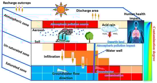
Figure 7.
Model of radionuclide propagation via air, soil, and groundwater transfer in the phosphate industry basin.
9. Conclusions and Perspectives
This study highlights the significant impacts of the phosphate industry on groundwater quality in the Gafsa-El Kef basin in Tunisia, emphasizing the presence of radionuclides and potentially toxic elements (PTEs) in both surface and groundwater. The extensive analysis of sediment, air, and groundwater samples using advanced gamma spectrometry and geochemical techniques reveals that uranium, thorium, and potassium isotopes are prevalent in the region, posing considerable health and environmental risks. The results demonstrate that radionuclides from phosphate mining and processing activities are widely distributed in the study area. These contaminants migrate through both surface runoff and subsurface flow, facilitated by the region’s geological and hydrological characteristics. The solute transport models indicate that artificial recharge from industrial activities significantly influences radionuclide distribution in the multi-layer aquifer system. This study confirms that groundwater in the region, especially in the shallow karst aquifers and deeper aquifers such as the Complex Terminal and North-Western Sahara Aquifer System, is contaminated with high levels of radionuclides and PTEs. The contamination is more severe in groundwater than in surface water, suggesting cumulative effects and significant groundwater–surface water interactions. The elevated concentrations of uranium, thorium, potassium, and nitrates in groundwater pose direct risks to human health through irrigation and domestic use. The high levels of radioactivity and toxic elements in groundwater used for agricultural purposes could lead to the accumulation of these contaminants in crops, subsequently entering the food chain and affecting human health. The decline in groundwater quality has profound implications for sustainable socioeconomic development in the region. The reliance on contaminated groundwater for agricultural and domestic use threatens the health of local populations and undermines the economic stability dependent on these water resources. Given the significant risks identified, there is a pressing need to rigorously monitor and manage groundwater resources in the study area. Implementing comprehensive groundwater protection strategies, including regular monitoring of radionuclides and PTEs, promoting sustainable agricultural practices, and controlling industrial discharges, is crucial for mitigating health and environmental risks. This study underscores the urgent need to address groundwater contamination in the Gafsa-El Kef basin. Ensuring the sustainability of groundwater resources in this arid and semi-arid region requires coordinated efforts between governmental bodies, industries, and local communities to protect and manage water resources effectively. The findings provide a foundation for future research and policy-making aimed at safeguarding groundwater quality and ensuring the health and well-being of the region’s inhabitants.
Author Contributions
Conceptualization, Y.H., M.G. and E.E.; methodology, Y.H.; software, Y.H.; validation, Y.H., M.G., E.E. and R.H.; formal analysis, Y.H.; investigation, Y.H. and E.E.; resources and data curation, R.K. and E.E.; writing—original draft preparation, Y.H.; writing—review and editing, Y.H., N.M., Y.A. and E.E.; visualization, R.H. and E.E.; supervision, R.K. and E.E. All authors have read and agreed to the published version of the manuscript.
Funding
This research received no external funding.
Institutional Review Board Statement
Not applicable.
Informed Consent Statement
Not applicable.
Data Availability Statement
Data are contained within the article.
Acknowledgments
The authors would like to thank the editor and the anonymous reviewers who greatly improved this paper with their relevant critiques; we also thanks Africa and Middle East Earth Scope Consulting and the Laboratory of Applied Research in Engineering Geology, Geotechnics, Water Sciences, and Environment (LAREGGWE). Special thanks to LEGAI, Setif, Algeria, for providing the TERRA material for gamma/beta radioactivity analysis. We are grateful to the staff of the LAM3E lab in Gafsa, Tunisia, and the private Sfax Tina lab, Tunisia. We also acknowledge the contributions of the GeoRS lab members in the Department of Earth and Atmospheric Sciences at the University of Houston, USA. Finally, we thank the staff of the International Association of Water Resources in the Southern Mediterranean Basin for their generous contributions of time and expertise, which greatly enhanced the quality of this manuscript.
Conflicts of Interest
The present paper is an original work; it is the first in the study area, and all the authors declare that they have no conflicts of interest. The authors jointly carried out this research study and they confirm that they are not associated with or involved in any profitable organization or company that has any financial interests.
References
- Beitz, H.; Schmidt, H.; Herzel, F. Occurrence, Toxicological and Ecotoxicological Significance of Pesticides in Groundwater and Surface Water. In Pesticides in Ground and Surface Water; Springer: Berlin/Heidelberg, Germany, 1994; pp. 1–56. [Google Scholar] [CrossRef]
- Balbus, J.M.; Boxall, A.B.A.; Fenske, R.A.; McKone, T.E.; Zeise, L. Implications of global climate change for the assessment and management of human health risks of chemicals in the natural environment. Environ. Toxicol. Chem. 2013, 32, 62–78. [Google Scholar] [CrossRef] [PubMed]
- El Gayar, A.; Hamed, Y. Climate change and water resources management in Arab countries. Springer international publishing AG-Euro-Mediterranean and surrounding regions. In Advances in Science, Technology & Innovation; Springer International Publishing AG: Cham, Switzerland, 2017. [Google Scholar]
- Khleifia, N.; Hannachi, A.; Abbes, N. Studies of uranium recovery from Tunisian wet process phosphoric acid. Int. J. Innov. Appl. Stud. 2013, 3, 1066–1071. [Google Scholar]
- Ayadi, Y.; Mokadem, N.; Besser, H.; Khelifi, F.; Harabi, S.; Hamad, A.; Boyce, A.; Laouar, R.; Hamed, Y. Hydrochemistry and stable isotopes (δ18O and δ2H) tools applied to the study of karst aquifers in Southern Mediterranean basin (Teboursouk area, NW Tunisia). J. Afr. Earth Sci. 2017, 137, 208–217. [Google Scholar] [CrossRef]
- Latifa, A.Y.; Lhoussaine, B.; Etienne, J.; Moussa, M.; Yassine, A.B.; Ahmed, E.M.; Jana, S.; Barbara, R. Impact of rock-water interactions and recharge on water resources quality of the Agadir-Essaouira basin, southwestern Morocco. Arab. J. Geosci. 2017, 10, 169. [Google Scholar] [CrossRef]
- Ayadi, Y.; Mokadem, N.; Besser, N.; Redhaounia, B.; Khelifi, F.; Harabi, S.; Nasri, T.; Hamed, Y. Statistical and geochemical assessment of groundwater quality in Teboursouk area (Northwestern Tunisian Atlas). Environ. Earth Sci. 2018, 77, 349. [Google Scholar] [CrossRef]
- Khelifi, F.; Besser, H.; Ayadi, Y.; Liu, G.; Yousaf, B.; Harabi, S.; Bedoui, S.; Zeghmi, K.; Hamed, Y. Evaluation of potentially toxic elements’ (PTEs) vertical distribution in sediments of Gafsa–Metlaoui mining basin (Southwestern Tunisia) using geochemical and multivariate. Environ. Earth Sci. 2019, 78, 53. [Google Scholar] [CrossRef]
- Khelifi, F.; Caporale, A.G.; Hamed, Y.; Adamo, P. Bioaccessibility of potentially toxic metals in soil, sediments and tailings from a north Africa phosphate-mining area: Insight into human health risk assessment. J. Environ. Manag. 2021, 279, 111634. [Google Scholar] [CrossRef] [PubMed]
- Khelifi, F.; Mokadem, N.; Liu, G.; Yousaf, B.; Zhou, H.; Ncibi, K.; Hamed, Y. Occurrence, contamination evaluation and health risks of trace metals within soil, sediments and tailings in southern Tunisia. Int. J. Environ. Sci. Technol. 2021, 19, 6127–6140. [Google Scholar] [CrossRef]
- Hamed, Y.; Khelifi, F.; Houda, B.; Ben Saad, A.; Ncibi, K.; Hadji, R.; Melki, A. Phosphate mining pollution in southern Tunisia: Environmental, epidemiological, and socioeconomic investigation. Environ. Dev. Sustain. 2023, 25, 13619–13636. [Google Scholar] [CrossRef]
- Hamed, Y.; Ayadi, Y.; Hadji, R.; Ben Saad, A.; Gentilucci, M.; Elaloui, E. Environmental Radioactivity, Ecotoxicology (238U, 232Th and 40K) and Potentially Toxic Elements in Water and Sediments from North Africa Dams. Sustainability 2024, 16, 490. [Google Scholar] [CrossRef]
- Hassan, N.M.; Mansour, N.A.; Fayez-Hassan, M.; Sedqy, E. Assessment of natural radioactivity in fertilizers and phosphate ores in Egypt. J. Taibah Univ. Sci. 2016, 10, 296–306. [Google Scholar] [CrossRef]
- Boumala, D.; Mavon, C.; Belafrites, A.; Tedjani, A.; Groetz, J.E. Evaluation of radionuclide concentrations and external gamma radiation levels in phosphate ores and fertilizers commonly used in Algeria. J. Radioanal. Nucl. Chem. 2018, 317, 501–510. [Google Scholar] [CrossRef]
- Besser, H.; Hamed, Y. Environmental impacts of land management on the sustainability of natural resources in Oriental Erg Tunisia, North Africa. Environ. Dev. Sustain. 2021, 23, 11677–11705. [Google Scholar] [CrossRef]
- Zhang, F.; Wang, Y.; Liao, X. Recognition method for the health risks of potentially toxic elements in a headwater catchment. Sci. Total Environ. 2022, 839, 156287. [Google Scholar] [CrossRef] [PubMed]
- Arabi, A.M.; El Ahmed, N.K.; Din, K.S. Natural radionuclides and dose estimation in natural water resources from Elba protective area, Egypt. Radiat. Prot. Dosim. 2006, 121, 284–292. [Google Scholar] [CrossRef] [PubMed]
- Benmarce, K.; Hadji, R.; Zahri, F.; Khanchoul, K.; Chouabi, A.; Zighmi, K.; Hamed, Y. Hydrochemical and geothermometry characterization for a geothermal system in semiarid dry climate: The case study of Hamma spring (Northeast Algeria). J. Afr. Earth Sci. 2021, 182, 104285. [Google Scholar] [CrossRef]
- Dragović, S.D.; Janković-Mandić, L.J.; Dragović, R.M.; Đorđević, M.M.; Đokić, M.M. Spatial distribution of the 226Ra activity concentrations in well and spring waters in Serbia and their relation to geological formations. J. Geochem. Explor. 2012, 112, 206–211. [Google Scholar] [CrossRef]
- Scanlon, B.R.; Faunt, C.C.; Longuevergne, L.; Reedy, R.C.; Alley, W.M.; McGuire, V.L.; McMahon, P.B. Groundwater depletion and sustainability of irrigation in the US High Plains and Central Valley. Proc. Natl. Acad. Sci. USA 2012, 109, 9320–9325. [Google Scholar] [CrossRef]
- Feng, W.; Zhong, M.; Lemoine, J.M.; Biancale, R.; Hsu, H.T.; Xia, J. Evaluation of groundwater depletion in North China using the Gravity Recovery and Climate Experiment (GRACE) data and ground-based measurements. Water Resour. Res. 2013, 49, 2110–2118. [Google Scholar] [CrossRef]
- Famiglietti, J.S. The global groundwater crisis. Nat. Clim. Chang. 2014, 4, 945–948. [Google Scholar] [CrossRef]
- Hamed, Y.; Ahmadi, R.; Demdoum, A.; Bouri, S.; Gargouri, I.; Ben Dhia, H.; Al-Gamal, S.; Laouar, R.; Choura, A. Use of geochemical, isotopic, and age tracer data to develop models of groundwater flow: A case study of Gafsa mining basin-Southern Tunisia. J. Afr. Earth Sci. 2014, 100, 418–436. [Google Scholar] [CrossRef]
- Hamed, Y.; Hadji, R.; Redhaounia, B.; Zighmi, K.; Bâali, F.; El Gayar, A. Climate impact on surface and groundwater in North Africa: A global synthesis of findings and recommendations. Euro-Mediterr. J. Environ. Integr. 2018, 3, 25. [Google Scholar] [CrossRef]
- Post, V.E.A.; Vassolo, S.I.; Tiberghien, C.; Baranyikwa, D.; Miburo, D. Weathering and evaporation controls on dissolved uranium concentrations in groundwater—A case study from northern Burundi. Sci. Total Environ. 2017, 607–608, 281–293. [Google Scholar] [CrossRef] [PubMed]
- Hadji, R.; Raïs, K.; Gadri, L.; Chouabi, A.; Hamed, Y. Slope failures characteristics and slope movement susceptibility assessment using GIS in a medium scale: A case study from OuledDriss and Machroha municipalities, Northeastern of Algeria. Arab. J. Sci. Eng. 2017, 42, 281–300. [Google Scholar] [CrossRef]
- Arif, K.; Khalid, P. Hydrostratigraphy and hydrogeophysical studies to delineate fresh and saline aquifer boundaries in Lesser Cholistan of Pakistan. PLoS ONE 2023, 18, e0292035. [Google Scholar] [CrossRef]
- Mokadem, N.; Hamed, Y.; Ben Saad, A.; Gargouri, I. Atmospheric pollution in North Africa (ecosystems–atmosphere interactions): A case study in the mining basin of El Guettar–M’Dilla (southwestern Tunisia). Arab. J. Geosci. 2014, 7, 2071–2079. [Google Scholar] [CrossRef]
- Marzougui, S.; Sdiri, A.; Rekhiss, F. Heavy metals’ mobility from phosphate washing effluents discharged in the Gafsa area (southwestern Tunisia). Arab. J. Geosci. 2016, 9, 599. [Google Scholar] [CrossRef]
- Colman, A.S.; Holland, H.D. The Global Diagenetic Flux of Phosphorus from Marine Sediments to the Oceans: Redox Sensitivity and the Control of Atmospheric Oxygen Levels; SEPM Society for Sedimentary Geology: Claremore, OK, USA, 2000. [Google Scholar] [CrossRef]
- Selvakumar, R.; Ramadoss, G.; Menon, M.P.; Rajendran, K.; Thavamani, P.; Naidu, R.; Megharaj, M. Challenges and complexities in remediation of uranium contaminated soils: A review. J. Environ. Radioact. 2018, 192, 592–603. [Google Scholar] [CrossRef] [PubMed]
- Veríssimo, C.U.V.; Santos, R.V.; Parente, C.V.; de Oliveira, C.G.; Cavalcanti, J.A.D.; Neto, J.D.A.N. The Itataia phosphate-uranium deposit (Ceará, Brazil) new petrographic, geochemistry and isotope studies. J. S. Am. Earth Sci. 2016, 70, 115–144. [Google Scholar] [CrossRef]
- Gao, S.; Tang, G.; Hua, D.; Xiong, R.; Han, J.; Jiang, S.; Zhang, Q.; Huang, C. Stimuli-responsive bio-based polymeric systems and their applications. J. Mater. Chem. B 2019, 7, 709–729. [Google Scholar] [CrossRef]
- Hamed, Y.; Awad, S.; Ben Sâad, A. Nitrate contamination in groundwater in the Sidi Aïch-Gafsa oases region, Southern Tunisia. Environ. Earth Sci. 2013, 70, 2335–2348. [Google Scholar] [CrossRef]
- Khaing, H.; Thakur, P. Rapid sequential separation method for 210Po and actinides in air flter samples. J. Radioanal. Nucl. Chem. 2017, 314, 1383–1392. [Google Scholar] [CrossRef]
- Nelson, A.W.; Eitrheim, E.S.; Knight, A.W.; May, D.; Mehrhoff, M.A.; Shannon, R.; Litman, R.; Burnett, W.C.; Forbes, T.Z.; Schultz, M.K. Understanding the radioactive ingrowth and decay of naturally occurring radioactive materials in the environment: An analysis of produced fluids from the Marcellus Shale. Environ. Health Perspect. 2015, 123, 689–696. [Google Scholar] [CrossRef] [PubMed]
- Bugai, D.; Dewière, L. Global Model for the 90Sr Transport in the Aquifer at Chernobyl Pilot Site: Model Calibration and Sensitivity Analyses; IRSN: Fontenay-aux-Roses, France, 2004.
- Dewière, L.; Bugai, D.; Grenier, C.; Kashparov, V.; Ahamdach, N. 90Sr migration to the geosphere from a waste burial in the Chernobyl exclusion zone. J. Env. Radioact. 2004, 74, 139–150. [Google Scholar] [CrossRef] [PubMed]
- Roux, C. Etude des Mécanismes de Transfert des Radionucléides en Aval de la Fosse T22 du Site Expérimental de Tchernobyl. Doctoral Dissertation, Aix-Marseille University, Marseille, France, 2013. [Google Scholar]
- Jenifer, M.A.; Jha, M.K. Comprehensive risk assessment of groundwater contamination in a weathered hard-rock aquifer system of India. J. Clean. Prod. 2018, 201, 853–868. [Google Scholar] [CrossRef]
- Yuan, Y.; Xiang, M.; Liu, C.; Theng, B.K.G. Chronic impact of an accidental wastewater spill from a smelter, China: A study of health risk of heavy metal(loid)s via vegetable intake. Ecotoxicol. Environ. Saf. 2019, 182, 109401. [Google Scholar] [CrossRef] [PubMed]
- Njuguna, S.M.; Makokha, V.A.; Yan, X.; Gituru, R.W.; Wang, Q.; Wang, J. Health risk assessment by consumption of vegetables irrigated with reclaimed wastewater: A case study in Thika (Kenya). J. Environ. Manag. 2019, 231, 576–581. [Google Scholar] [CrossRef] [PubMed]
- Langmuir, D. Aqueous Environmental Geochemistry; Prentice Hall: Upper Saddle River, NJ, USA, 1997; p. 600. [Google Scholar]
- De Souza, A.L.; Cotrim, M.E.B.; Pires, M.A.F. An overview of spectrometric techniques and sample preparation for the determination of impurities in uranium nuclear fuel grade. Microchem. J. 2013, 106, 194–201. [Google Scholar] [CrossRef]
- Kertes, A.S.; Guillaumont, R. Solubility of UO2. A comparative review. Nucl. Chem. Waste Manag. 1985, 5, 215–219. [Google Scholar]
- Bi, Y.; Hyun, S.P.; Kukkadapu, R.K.; Hayes, K.F. Oxidative dissolution of UO2 in a simulated groundwater containing synthetic nanocrystalline mackinawite. Geochim. Cosmochim. Acta 2013, 102, 175–190. [Google Scholar] [CrossRef]
- Durakoviæ, A. Medical effects of internal contamination with uranium. Croat. Med. J. 1999, 40, 49–66. [Google Scholar]
- Alam, M.S.; Cheng, T. Uranium release from sediment to groundwater: Influence of water chemistry and insights into release mechanisms. J. Contam. Hydrol. 2014, 164, 72–87. [Google Scholar] [CrossRef]
- Ulrich, S.; Gillow, J.; Roberts, S.; Byer, G.; Sueker, J.; Farris, K. Hydrogeochemical and mineralogical factors influencing uranium in background area groundwater wells: Grants, New Mexico. J. Hydrol. Reg. Stud. 2019, 26, 100636. [Google Scholar] [CrossRef]
- Van, K. Cadmium and Other Minor Elements in World Resources of Phosphate Rock; The Fertiliser Society Proceedings: York, UK, 1997; No. 400; pp. 15–22, 30–31. [Google Scholar]
- Van, K. World Phosphate Rock Reserves and Resources; IFDC Publication: Muscle Shoals, AL, USA, 2010; p. 33. [Google Scholar]
- U.S. Geological Survey. Mineral Year Book. In Phosphate Rock; U.S. Geological Survey: Reston, VA, USA, 2011. [Google Scholar]
- NEA; IAEA. Uranium 2020: Resources, Production and Demand; Public Online Report; NEA No. 7551; OECD: Paris, France, 2020. [Google Scholar]
- Gandhi, T.P.; Sampath, P.V.; Maliyekkal, S.M. A critical review of uranium contamination in groundwater: Treatment and sludge disposal. Sci. Total Environ. 2022, 825, 153947. [Google Scholar] [CrossRef]
- Hidouri, N.; Missaoui, R.; Jraba, A.; Yousaf, B.; Sleimi, N.; Hamed, Y. Assessing the vertical distribution and health risks of trace metal elements in phosphogypsum-enriched agricultural soils of typical peri-urban areas in Southwestern Tunisia. Water Air Soil. Pollut. 2023, 234, 332. [Google Scholar] [CrossRef]
- Serio, F.; Miglietta, P.P.; Lamastra, L.; Ficocelli, S.; Intini, F.; De Leo, F.; De Donno, A. Groundwater nitrate contamination and agricultural land use: A grey water footprint perspective in Southern Apulia Region (Italy). Sci. Total Environ. 2018, 645, 1425–1431. [Google Scholar] [CrossRef] [PubMed]
- He, S.; Wu, J. Hydrogeochemical characteristics, groundwater quality and health risks from hexavalent chromium and nitrate in groundwater of Huanhe Formation in Wuqi County, northwest China. Expo Health 2019, 11, 125–137. [Google Scholar] [CrossRef]
- Li, P.; He, X.; Guo, W. Spatial groundwater quality and potential health risks due to nitrate ingestion through drinking water: A case study in Yan’an City on the Loess Plateau of northwest China. Hum. Ecol. Risk Assess. 2019, 25, 11–31. [Google Scholar] [CrossRef]
- Hamdi, A.; Ben Jamaa, N.; KallelKamoun, I. Potential use of phosphogypsum in paving blocks. Green Mater. 2021, 9, 97–107. [Google Scholar] [CrossRef]
- Garbaya, H.; Jraba, A.; Khadimallah, M.A.; Elaloui, E. The Development of a New Phosphogypsum-Based Construction Material: A Study of the Physicochemical, Mechanical and Thermal Characteristics. Materials 2021, 14, 7369. [Google Scholar] [CrossRef]
- Hashim, M.A.; Mukhopadhyay, S.; Sahu, J.N.; Sengupta, B. Remediation technologies for heavy metal contaminated groundwater. J. Environ. Manag. 2011, 92, 2355–2388. [Google Scholar] [CrossRef] [PubMed]
- He, X.; Li, P. Surface water pollution in the middle Chinese Loess Plateau with special focus on hexavalent chromium (Cr6+): Occurrence, sources, and health risks. Expo Health 2020, 12, 385–401. [Google Scholar] [CrossRef]


Disclaimer/Publisher’s Note: The statements, opinions and data contained in all publications are solely those of the individual author(s) and contributor(s) and not of MDPI and/or the editor(s). MDPI and/or the editor(s) disclaim responsibility for any injury to people or property resulting from any ideas, methods, instructions or products referred to in the content. |
© 2024 by the authors. Licensee MDPI, Basel, Switzerland. This article is an open access article distributed under the terms and conditions of the Creative Commons Attribution (CC BY) license (https://creativecommons.org/licenses/by/4.0/).