A sharing cities approach focuses on bring local people together through shared activities and cooperation for the benefit of the city and includes initiatives such as carsharing, community currencies, cohousing, hackerspaces, timebanks and tool or kitchen libraries. These new forms of sharing, enabled by technological devices and platforms [
1] work by enabling citizens to create, adapt and exploit data [
2] and can create new ways in which citizens participate in the governance of the city. For example, civic apps, developed by citizens, civic organisations and commercial companies [
3] have become widespread and typically create some form of two-way interaction where citizens contribute to commenting on or providing data on public services usually offered by the city such as crime prevention, rubbish collection, public transportation and pollution reduction. Mclaren and Agymen present as new model for collaboration and sharing around the city where “the same measures that enable sharing online, also–if civil liberties are properly protected–enable collective politics online. We see the increasingly blurred nexus between urban- and cyberspace enabling transformation–this time in the political domain. These spaces are fundamentally important for forms of participation invented and controlled by the people” [
4]. This takes a model of participation, or sharing data that is termed ‘co-production’ whereby ‘citizens perform the role of partner rather than customer in the delivery of public services’ [
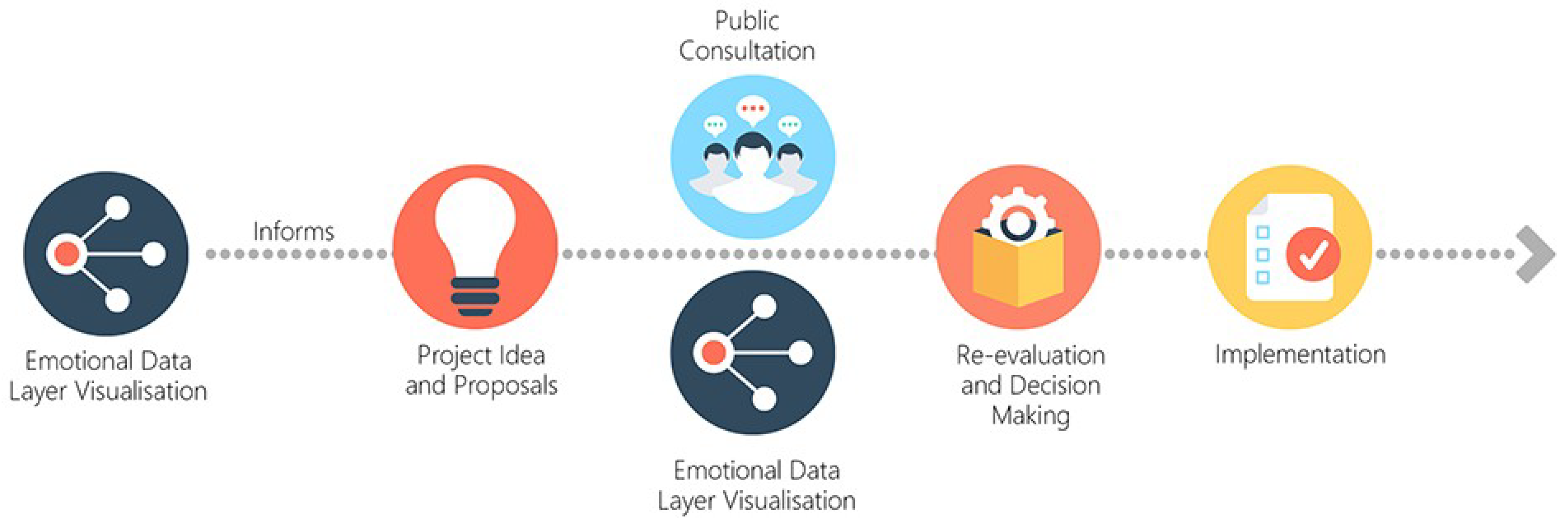
5]. The challenge is how to enable citizens who are non-experts to gather, analyse and share data in a way that can meaningfully contribute to urban planning processes. The aim of this paper is to look at the potential of emotional data for enabling participation in urban planning, that contributes towards a shared cities approach. The objective of this approach to propose that a sharing emotional data can enable better insights of the city and its inhabitants which could lead to a citizen-centred approach in urban planning processes.
In this paper, we take the approach that sharing practices present an alternative model of participation in city decision-making. Conventional citizen participation methods in city planning are typically linear and include referenda, public hearings, public surveys, charettes, public advisory committees or focus groups which often require the participants to be physical present at particular time and place (see
Figure 1). The qualitative nature of data gathering and sharing means that citizens that have input into such consultations typically participate through methods such as completing surveys and contributing verbal comments, which are qualitative in nature and require further analysis to be used effectively. These forms of data are not easily translatable into the types and format of data and outcomes that are used by urban planners; such as urban plans, maps and GIS data. In addition factors such as the time required of citizens to participate often results in apathy among citizens [
6], so that actual participation rarely represents a majority of inhabitants or involves the full range of stakeholders [
7].
Digital technologies can address some of the issues of participation in the urban planning process by enabling a more accessible system for the public to shape their neighbourhood’s future [
8]. Munster et al. outline potential advantages of digital participation which include the use of wider pool of knowledge through broader audience and participants, which creates an interactive and communication-oriented planning process [
9]. They can lower barriers for participation, involve a wider range of participants, and by enabling people to discuss urban design proposals in place can foster interest in public participation [
9]. This offers new perspectives for designers and planners to “transforming planning work into an iterative, agile work process, in contrast to sequential and linear workflows that have shaped urban design practice in the past” [
9]. Crivellaro et al. [
10] have looked at how local people use data sharing through Facebook to mobilise around a local social movement. They recognised the importance of forming a like-minded community, but also acknowledged the struggle of the group to translate their emotions to the authority and decision makers. Hasler et al. [
11] in another research found that the multiplication and diversity of contributions by citizens through digital participation increases complexity which means that prioritising relevant data can be problematic. This illustrates how data sharing can facilitate discussions that are planning-related, but turning them into actionable policies proven to be difficult. The research question this paper therefore seeks to explore is: Can sharing emotional data offer a method for participation in the urban planning process?
The paper presents a potential methodological contribution in terms of the incorporation of physiological sensing device and GPS tracking technologies for measure and analysing emotional data in urban environments. To do this, we first review the literature on the urban planning process, showing how the development of the discipline has sought to enable citizen participation. This is mapped against Arnstein’s ‘Ladder of Participation’ to highlight how much of this participation typically does not enable citizens to control and act in the process, and is therefore the participation is often tokenistic. The potential of incorporating digital tools for participation is presented, and in particular, the value of incorporating emotional data as a way of capturing a more person- centric understanding of urban space. In the study described in the paper, a small number of participants used a galvanic skin response (GSR) linked to location data to record stress levels in a walk through an urban city centre space with different characteristics. The findings aim to explore whether this emotional data might have benefit for enabling new models of shared data in urban planning processes.
1.1. The Challenge of Participation in the Urban Planning Process
“Cities have the capability of providing something for everybody, only because, and only when, they are created by everybody” [
12].
Many people now live in cities, but despite Jacob’s plea above, very few participate in how they are created, designed and planned. Therefore, the contribution of this study addresses the following broader question: ‘how to enable meaningful participation in the urban planning process’? To do this, the paper first provides some context on how urban planning evolved and the developing role of participation. The origins if urban planning in the western world in the early 20th Century, were heavily influenced by the rational-comprehensive approach where the planning sequence involves: a survey of the region, an analysis of the survey, and finally the development of the plan [
13]. Hall [
14] argued that Geddes “gave planning a logical structure” by developing the survey-analysis-plan sequence of planning. However, this method of planning has been criticised to be too top-down; seeing the planner as “the omniscient ruler, who should create new settlement forms without interference or question” [
14] as well as being too reductionist as planners have to make assumptions and predictions which required them to have complete certainty [
15]. This then caused the planners to proceed on the basis of simplifying the world around them which later led to a lot of failure of the predictions [
15]. The failures of the rational-comprehensive approach in urban planning led it to being succeeded by synoptic planning approach in 1960s and Hall argued that this change represents a fundamental shift in the role of the planners and their relationship with the public. However, Faludi [
15] argued that this early form of participation was still based on the assumption that the society is homogenous–implying the homogeneity of interest. This means that participation is only required to validate and uncritically legitimise the goals of planning and any objection to planning proposal tends to be stigmatised [
15].
Even when public participation has become an integral part of current urban planning process, Innes and Booher [
6] argued that they still “do not achieve genuine participation”. This is because current form of public participation does not satisfy members of the public that they are being heard and often does not improve the decisions that agencies and public officials make and [
6]. The scepticism posed by Innes and Booher [
6] to the way that current participation is being practiced could be traced back to Arnstein’s widely known ‘Ladder of Participation’ [
16]. As she put it, “there is a critical difference between going through the empty ritual of participation and having the real power needed to affect the outcomes of the process” [
16]. The fundamental point of these criticisms was that if urban planners seek public participation, it is necessary that there be a redistribution of power [
16]. She regarded power in public participation as a ladder or a spectrum ranging from ‘nonparticipation’ through to ‘degrees of citizen power’ (see
Figure 2), which correspond to the degree of power or control participants can exercise in the quest of shaping the outcome. The ladder outlines steps of public participation from manipulation (level 1), education (level 3), and consultation (level 4), through to sharing power through ‘partnership’ (level 6) and beyond.
Notably, Arnstein’s framework regards consultation as ‘tokenism’ similar to the way Innes and Booher [
6] viewed the level of public participation in current urban planning process. However, Painter [
17] argued against Arnstein’s analysis by stating that her ladder of participation model inaccurately apprehends power i.e., it confuses ‘potential power’ with ‘actual power’ [
17]. While the official decision-making power may rest with institutional decision-makers in a consultation process, to regard the process as tokenistic disregards the fact that “if the exercise of influence [by participants] is effective, then this formal power is an empty shell” [
17] (p. 23). He also argues that Arnstein’s model often assume decision-making in planning occurs at a single point in the process. This ignores the fact that there is rarely an identifiable, or single, ‘point of decision’ in policy-making [
17]. The primary value of this discussion is that it exposes that participation in planning can include the exercise of both formal and informal power. Hence, having power in decision-making processes is not the only way towards achieving genuine participation, as it could also be realised through ranges of other participatory activities—as long as the engagement with citizens contribute positively towards the outcome of a planning project.
1.1.1. Emotions and Planning
This paper explores whether sharing emotional data about a particular city setting can be used to inform the urban planning process. Although the link between the built environment and human’s emotional aspects in urban planning research has found a growing interest in recent years, it is still a rather new approach in the field [
18]. Typically, in urban planning, planning is seen as an objective process, so emotion is not seen as qualities or analysis that can be meaningfully included in decision making [
19]. They believe that urban planners should avoid allowing emotions to influence their analysis or recommendations and this is largely due to the fact that urban planners are taught to operate in a rational manner [
19]. Despite the neglect of emotional aspects by many planning officials, there are also some urban planners who do recognise the importance of emotions within the field. For example, Lynch [
20] recognises the emotional aspect through its link with emotions and mental maps while Ferreira [
21] has urged that emotions should be presented as constructive drives with the power to positively inspire the planner to become a more competent professional. Porter et al. [
22] on the other hand have claimed that attachments to community members improve the ability of planners to understand and work with residents while Gunder and Hillier [
23] have interpreted planning issues through a Lacanian psychological model which acknowledge the entire process of becoming and being a planner is typically associated with strong emotional experiences. These authors have provided a meaningful theoretical discourse in terms of acknowledging the importance of emotions within urban planning. However, the majority of them have kept their focus on the planner side of the equation rather than on the users’ side. Most of them recognise that planners should positively address emotions but very few have put the emphasis on citizens’ emotional interactions with the urban environments itself. This should not be the case if we were to truly understand the relationship between emotions and urban spaces. According to Zeile et al. ‘the long-term goal is to develop a new information layer for planners, in which a visualization of the measured spatial perception is possible. These visualizations allow conclusions about human behavior in an urban environment and enable a new citizen-centered perspective in planning processes’ (Zeile, Resch, Exner, and Sagl, 2015). Hence, by linking it to public participations and the developments of digital tools, the next subsection will review some of the literature and studies around the spatial-emotional interactions of the city’s users as its main focus to understand the significance of emotions in the urban planning field.
1.1.2. Digital Tools as Means for Measuring Emotions
Recent technological developments have allowed the incorporation of emotions in public participation within the planning field. It also allows current urban planners to increase their understanding of the relationship between citizens and urban spaces by measuring their emotions using newly developed digital tools. Most of the studies around this topic can largely be divided into three categories based on the tools they have used to extract emotional data either through: (1) social media, (2) mobile apps, or (3) physiological wearable devices. The similarities within all of these studies and perhaps the most important one for incorporating emotional experiences in spatial analysis is the capability to cross reference emotional data with accurate locational data i.e., the ability to geo-locate those data to a specific place within a city. For example, under the first category, Mislove et al. [
24] extract the moods of people from different cities by mining information on social media, in this case, Twitter. This information however tends be at a low level of granularity; it is generally at a large spatial scale such as city, state or region and not collected at a detailed spatial level, such as a street or a city centre. Nevertheless, there is other recent research on mining emotional responses towards particular spaces from social media such as Tauscher and Neumann [
25] who generated sentiment maps of tourist locations.
The Urban Emotion Research Lab developed a methodology for the extraction of contextual emotion information for decision support in spatial planning which enabled crowdsourcing physiological conditions (technical sensors measuring psycho-physiological parameters) and subjective emotions (human sensors contributing subjectively perceived emotions) [
26,
27,
28]. Drawing on this work, Hauthal and Burghardt [
29] and Aiello et al. [
30] both extract location-based emotions from photo titles, descriptions, and tags from Panoramio and Flickr respectively to generate maps of specific streets within various cities with emotional attributes. Mody et al. designed a location-based social networking tool that enables users to share and store their emotional feelings about places ‘WiMo’ [
31]. They found that it was possible to create a recognisable and useable framework for gathering users individual emotional responses in a shared map interface. Key to this was defining ‘places’ rather than distinct geographical locations as these elicited an emotional response. Meanwhile, Zeile et al. [
32] has established a dedicated algorithm to source emotional expressions from Twitter before plotting them onto the map of downtown Boston, USA.
Some researchers have started to focus on developing mobile apps, to gather users’ wellbeing and feelings and to relate them to the geographic reference of their occurrence. For example, Ettema and Smajic (2015) used smartphones to gather self-recorded experiences of students during a walk. They have then later found out that the level of happiness was the highest in areas where many activities were happening and where a lot of people were around (Ettema and Smajic, 2015). MacKerron and Mourato (2013) in their project “Mappiness” used an iPhone app to collect frequent reports of temporary happiness at random times. They found that participants are generally happier in green or natural environments than in urban environments (MacKerron and Mourato, 2013). Similarly, Klettner et al., (2013) designed mobile apps called EmoMap to collect people’s emotional responses to space through mobile phones, as well as modelling, and visualizing these data. The findings indicate that environments varying according to the amount of vegetation and traffic are perceived differently, with highest positive ratings for the urban-green area, and lowest ratings in the heavy traffic urban area (Klettner et al., 2013).
While semantic analysis from social media data and citizen feedbacks from mobile apps offer subjective evaluations on emotional experience of participants, physiological emotional extraction technique using wearable devices propose the investigation of the more objective element of emotions. This is on the basis that physiological responses would provide useful indications of the users’ current emotional states when they interact with the physical environment. Over the last ten years, some urban researchers have been investigating this relationship and Nold’s [
33] ‘emotional cartography’ is perhaps the most significant in laying a fundamental underpinning to explore the changes in physiology in the urban space. His ‘BioMapping’ project, undertaken between the years 2004 to 2009, was the first to integrate GPS data with biometric human sensor data and explore the idea of visualising cartographically referenced emotional data. In the fieldwork, he gathered the change of the skin conductance levels and skin temperature of participants wearing a galvanic skin response (GSR) device as they walked in several cities, which was then mapped based on their GPS locations to describe areas in terms of emotional arousal [
33].
Similar work was done by Zeile et al. [
34] who mapped the stress levels of cyclists in Cambridge, Massachusetts by measuring skin conductance levels during their ride using a GSR device. They also attached a video recording device to allow footages to be taken along the route in order to accurately understand what caused the physiological changes in their participants [
34]. A dedicated smartphone app was then used to allow geo-tagged reporting of the experiment. Their findings include the detection of what caused negative arousal in cyclists and they found out that the triggers include dangerous intersections, physical obstacles, pedestrians crossing, cars passing close by and damaged road surface [
34]. They also mapped the cycling route with all the moments of stress and triggers as well as some specific emotions based on the input from the participants and their rides.
The studies conducted by Nold [
33] and Zeile et al. [
32] all benefited from the use of the GSR device that offers physiological data collection of emotions of the participants. As the GSR device measures levels of emotional arousal through the change in skin conductance and resistance levels, these data can be easily quantified resulting in a more objective measure of emotions rather than just qualitative. This method is valuable since objective measurement of emotions has proven to be beneficial in terms of producing a more accurate representation of emotions. Hence, the next subsection will explore the mechanism operating the GSR device and its uses in measuring negative emotional arousal within the field. As mentioned previously, the work of Zeile and colleagues and Nold have undertaken key work [
28,
33,
35] that has objectively investigated the relationship between emotions and physical environments using physiological responses methods. This work has laid important theoretical and methodological foundations for integrating the use of galvanic skin response (GSR) within urban spatial analysis and city planning, hence. In this paper, we draw on these methodological approaches and further investigate the link between and urban spaces to gain understanding of how features in the urban space can be mapped against emotional response and the corresponding potential for this in participatory urban planning.
1.1.3. Physiological Measures of Stress Levels Using a GSR Device
A range of physiological measures has been employed to assess emotions in research. As mentioned before, physiological responses of the sympathetic nervous system, especially changes in electrodermal activity (EDA), blood pressure, heart rate, and cortisol levels, are broadly used to reflect changes in emotional arousals [
36]. However, because the change in blood pressure and heart rate are also influenced by physical activities, the EDA offers a more accurate measure of emotional arousal [
36]. Boucsein have discussed EDA at length and regarded it as a common term for all electrical phenomena including active and passive electrical properties which occurs in the skin [
37]. One of the most well-known EDA measures is the galvanic skin response (GSR) defined simply as ‘a change in the ability of the skin to conduct electricity’ [
37]. GSR can be measured using a GSR device in which the fundamental physiological mechanism that operates the response is ‘the subtle change in sweat secretion from eccrine sweat glands throughout the body which increased when there is a high level of emotional arousal [
35]. This phenomenon is called emotional sweating and can be observed and measured most easily and accurately on hands and feet. As the secretion of sweat increases, skin surfaces become moistier, thus improving the conduction of an electric current [
35]. This allows for the skin conductance and resistance level to increase or decrease, and this change is recorded by the GSR device.
The current state-of-the-art in physiological sensor data analysis research suggests that negative emotional arousal can be correctly distinguished through the analysing of the skin conductance level. According to leading researchers in the field, such as Kreibig [
38] and Rodrigues et al. [
39], skin conductivity increases (while its resistivity decreases) when a negative experience occurs as this negative arousal is an indicator for a stress event. Zeile et al. supported this argument as their study has found out that “[if] for instance a test person has the experience of anger or fear—a negative emotion—skin conductance (the difference between sweat production and absorption of the skin) increases” [
32]. Dakker et al. found in studies that GSR can be used not just to detect emotions but also for change detection in emotions since ‘emotional experiences trigger changes in autonomic arousal quite impressively’. This can be used to link levels of emotional arousal with stress [
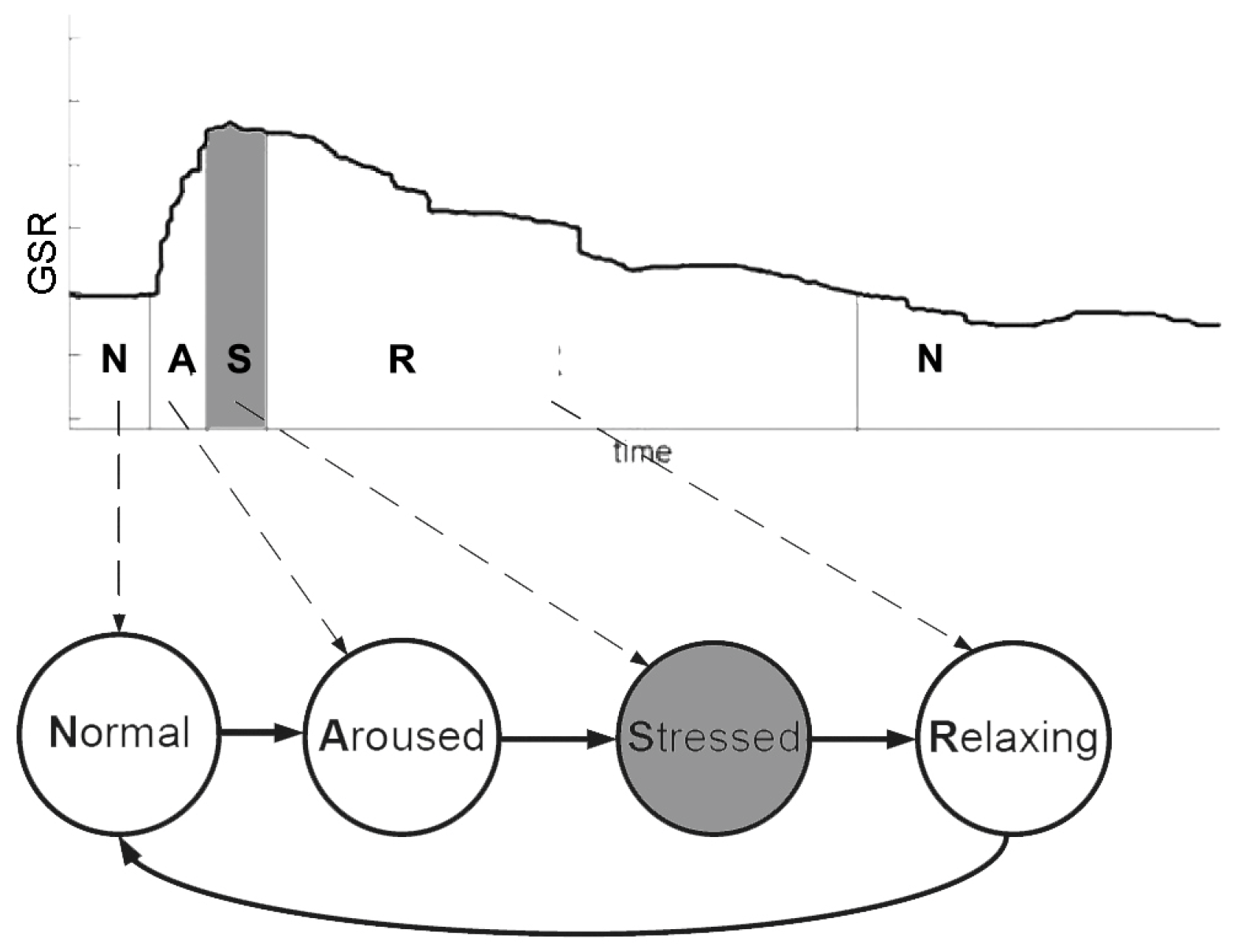
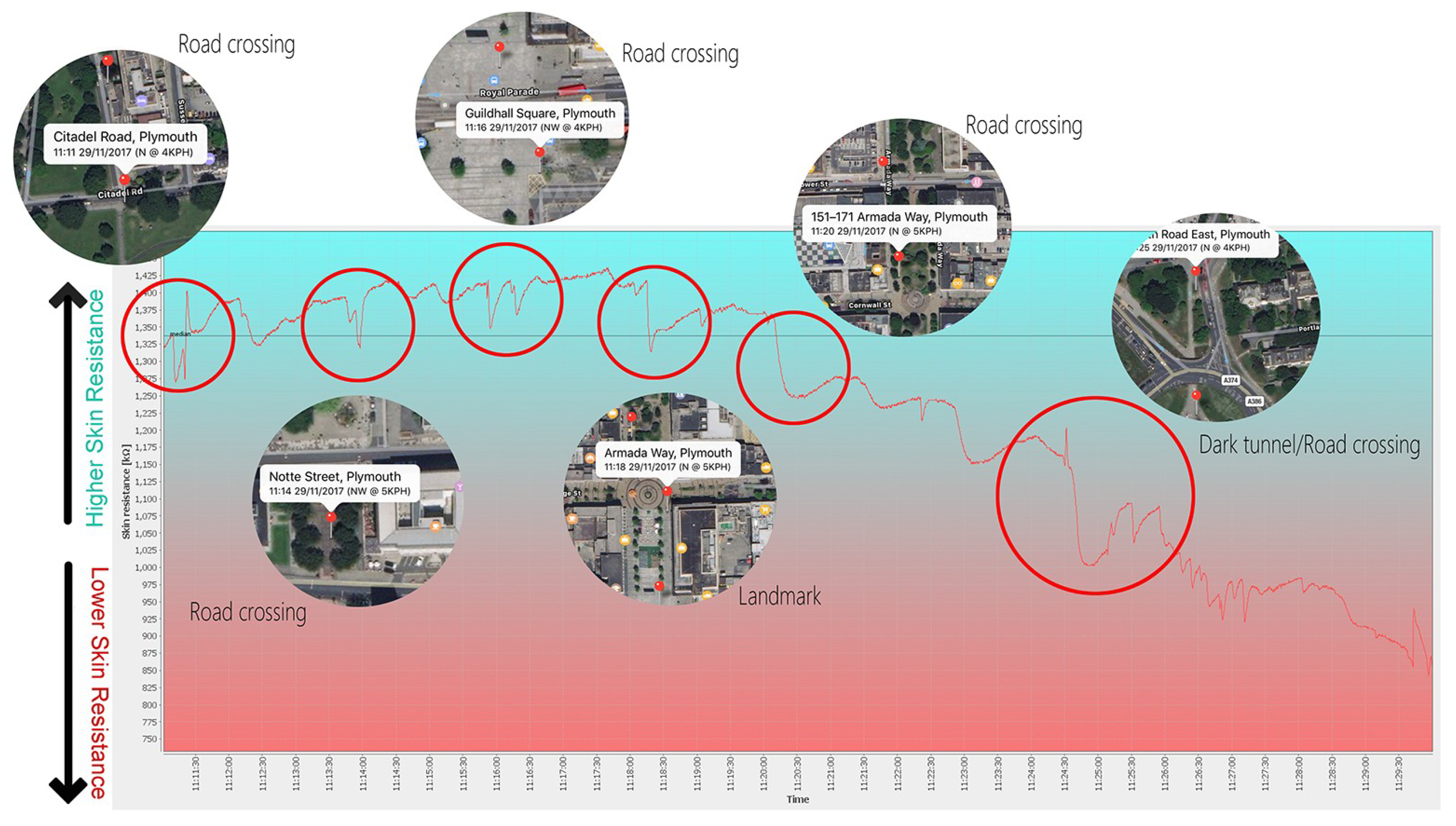
40]. Bakker et al. distinguish stress in patterns of sharp rising emotional arousal at the peak, prior to a slow return to a relaxed state (see
Figure 3) as highlighted in grey in the adapted GSR data graph below.
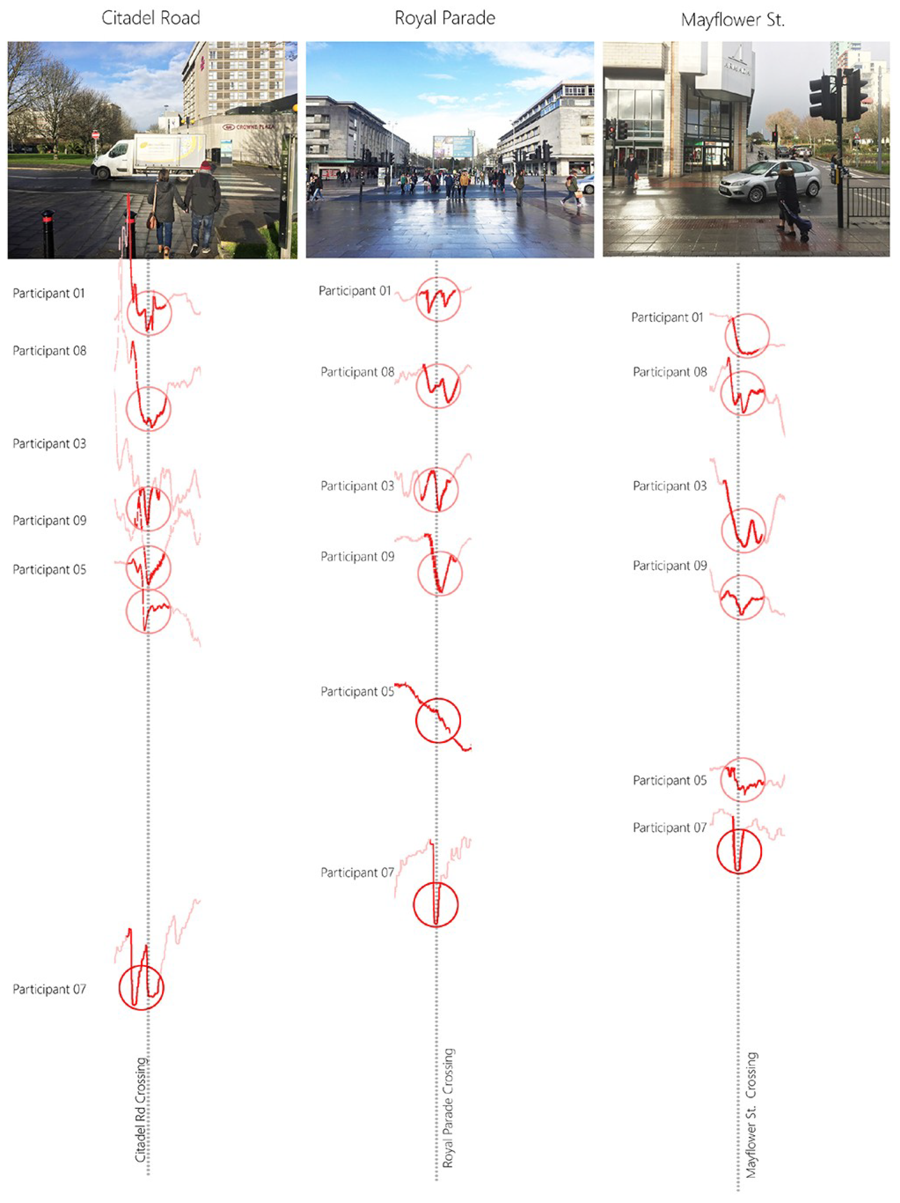
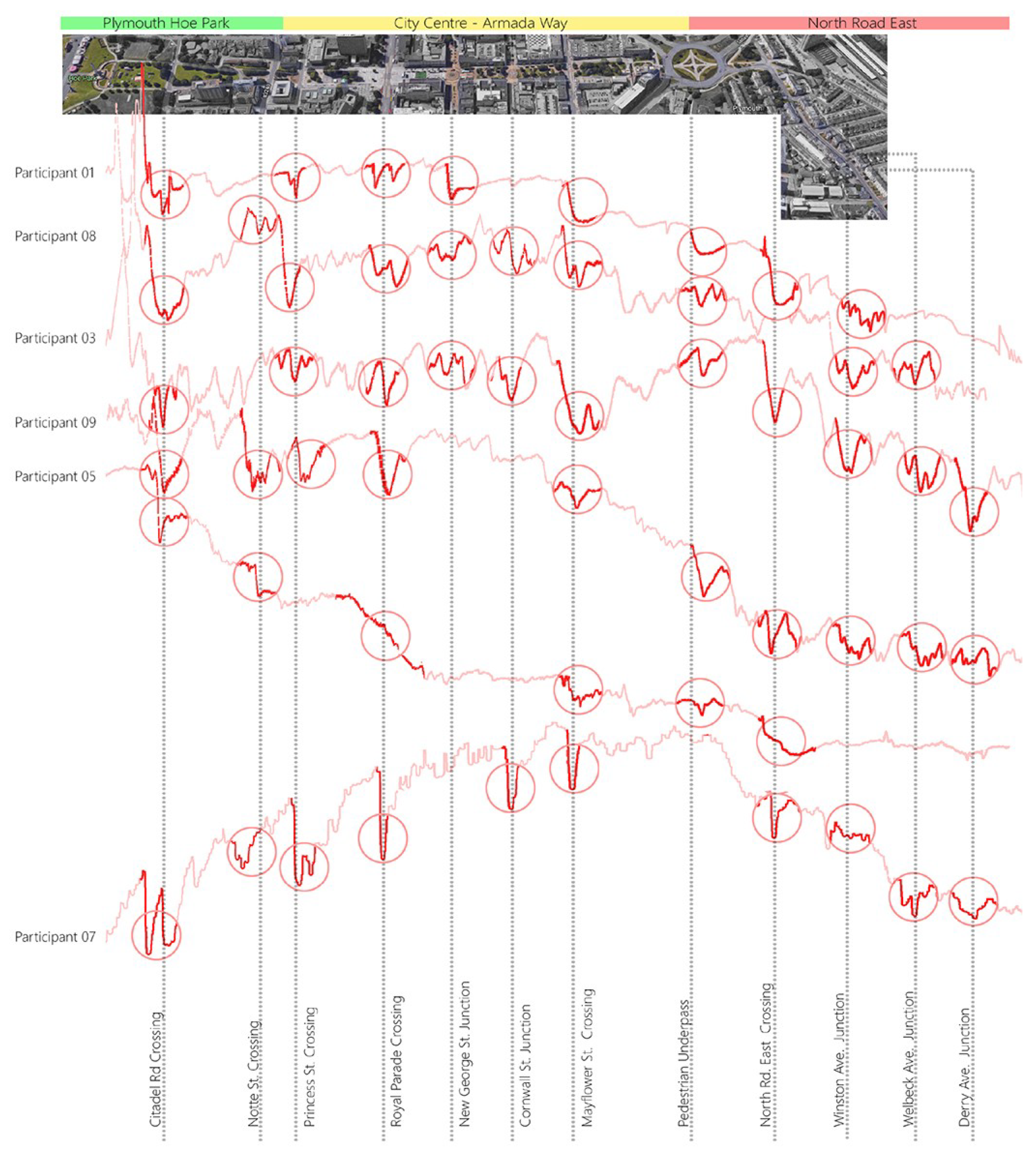
In this paper, we focus on change detection in emotions using a GSR device and through correlating with changes in the urban context aim to investigate whether this has potential for mapping emotional change to particular urban planning features and qualities.


