Abstract
To contribute to the debate on climate-proof urban regeneration, the illustrated study seeks to understand how the provision of new multiscalar, multidimensional, and integrated planning tools based on sustainable and resilient strategies can guarantee high levels of urban, environmental, and energy efficiency and quality, as well as circularity of resources, counteracting the effects deriving from climate change. Starting from some regulatory and design references that integrate a new ecologically oriented city model into the planning of urban projects, the contribution identifies in the construction of green and blue infrastructures (GI) new design metaphors capable of improving biodiversity; favoring ecological and energy transition; restoring the quality of the air, water, and soil environmental matrices with natural solutions; and making cities truly inclusive, sustainable, and resilient. The methodology adopted for the design of the “Acilia–Madonnetta” Urban and Metropolitan Centrality in the Municipality of Rome simulates a planning process for part of the X Municipality by applying an iterative and interscalar logic, an articulation of levels and phases with the aim of prefiguring the construction of a GI characterized by new ecological-environmental and functional endowments strictly related to the promotion of an efficient, smart, and green city. The contribution highlights the potential and limits of the proposed experimentation, relating both to the quality and innovation of design solutions and possible evolutionary lines and to the lack of clear institutional governance that is limiting the implementation of projects.
1. Introduction
The contemporary city, traditionally understood as a place of density, of physical, functional, and social complexity, and of cultural inheritance [1], the result of settlement pathologies, socioeconomic imbalances, and ecological/environmental fragility in recent decades, has become the space for inequalities, fragmentation, alienation, and insecurity. Urban areas, which cover only 2% of the Earth’s surface but produce 60% of pollutant emissions and 2/3 of greenhouse gases, concentrate many of the risks derived from climate change, extreme weather events, flooding, heat waves, drought, and so on [2,3], in addition to—as many research efforts are confirming [4]—a greater infectiveness of pandemic viruses, because it is in them that the interaction between the human and the physical environments enter into conflict, with negative consequences on human health and well-being, socioeconomic development, and ecosystem equilibria.
These critical areas have brought to the center of the most advanced fronts of the scientific debate, public agendas, and major international organizations the need to more deeply analyze the close relationship between climate change and risks, and to place these problems within the broader theoretical and methodological framework of the sustainability of development [2,3,5,6,7,8,9,10]. Integrating interventions to mitigate and adapt to climate change is in fact the foundational strategy of many international documents [5,11,12,13,14], where urban planning and design take on a guidance and coordination role, promoting transcalar, multi-objective approaches and actions for a local development based upon innovative social practices and ecologically oriented economies [15]. In the current, complex phase, marked by the waste of non-renewable resources, the effects of global warming, the economic and social crisis, and the health emergency, cities and territories must grapple with new needs, new players, and innovations of plan and design, by combining development, innovation, and environmental quality.
This necessarily requires a paradigm shift capable of making a multitude of dimensions—environmental, economic, social, institutional dimensions, as well as those related to settlement and energy [16]—interact, and of combining “regeneration” and “resilience” [17], by promoting new policies and strategies aimed at improving natural cycles, decarbonizing the energy system [12,18], and using innovative materials and technologies for the environment, transport, well-being, and human health. The objective of guaranteeing high levels of urban and environmental quality, energy efficiency, and circularity of resources must be entrusted to an innovated system of participatory and cooperative practices, institutional geometries, and interscalar and integrated planning instruments based upon adaptive and resilient strategies, and new planning metaphors such as green and blue infrastructure (GI) [19], while putting an end to biodiversity loss and the decay of ecosystem services (ESs) [20,21].
1.1. Ecological Networks and Green and Blue Infrastructure
In the 1990 s, in parallel with the technological leap triggered globally by the World Wide Web, ecological connections and networks were also progressively introduced into planning instruments on the various scales, such as the new paradigm for biodiversity enhancement and conservation, the protection of landscape/environmental component, the eco-compatibility of transformations, and the increase of natural ecosystems [22,23]. Extending the concept of network to the ecological-environmental components has helped form urban planning instruments endowed with a greater awareness of environmental problems, contributing towards recognizing the territorial invariants [24] and towards identifying the possible levels of integration among the systems affected by processes of co-evolution of manmade and natural matrices. Among the multiple definitions, the most recurrent one considers the ecological network (EN) as an interconnected system of habitats whose biodiversity, with reference to the plant and animal species threatened by transformation processes [25], is to be safeguarded. Building an EN means creating or reinforcing the connections and the areas of exchange among isolated natural components and areas, so that decay and fragmentation might not yield their negative effects on biodiversity, such as gene pool impoverishment and the infertility of species.
Starting from the concept of multifunctional EN articulated as a network in support of sustainable development, recent years have seen the rise of a new planning metaphor that has extended the term “infrastructure” to cover environmental components as well. “Green (and blue) infrastructure” (GI), defined by the European Commission as “a strategically planned network of natural and semi-natural areas with other environmental features designed and managed to deliver a wide range of ecosystem services” [19,26,27], in fact goes beyond the traditional concept of EN to achieve an integration between ecological/environmental demands and the demands of socioeconomic and cultural development, by enhancing cultural identity, reconfiguring urban structures, strengthening transportation networks, and effecting the ecologically-oriented transformation of the productive system [28]. GI offers an integrated approach to managing the territory and to resilience, while mitigating the effects caused by climate change and hydrogeological instability, improving biodiversity, increasing the territories’ economic value, and, restoring, with nature-based solutions (NBSs), the quality of the air/water/soil matrices. Understood as systemic networks capable of making natural components and manmade components interact, GI constitutes the most suitable approach for triggering processes of urban and environmental regeneration with reference to the specific features of local settings [20].
1.2. Green and Blue Infrastructure in an Urban Setting
In an urban setting, GI, defined as a structural and multifunctional mesh, can play a decisive role for the rebalancing of urban ecosystems, the reconfiguration of public space, the promotion of green economies, and the virtuous recycling of resources, triggering a new urban metabolism [29,30]. In European cities where more than 70% of the population lives [31], the problems connected to consumption and to sealing urban soil, the reduced ability of bodies of water to intercept and carry rainwater, and the heat island phenomenon require an integrated landscape/environment/architecture approach able to reduce the speed of surface runoff and to store rainwater in the ground or in other collection, purification, and recycling systems. In this perspective, sustainable urban drainage techniques (Sustainable Drainage Systems—SuDS) [32] (green roofs, permeable pavement. rain gardens, bioswales, green trenches, biolakes, etc.), as integral parts of GI, allow cities to act like sponges (“sponge cities”), facilitating natural water circulation, restoring the hydrological balance, and reducing the pollutant load of bodies of water and the effects of so-called “urban floods”.
Moreover, in recent years, to respond to the effects of air pollution, energy waste, reduced natural capital, and the impoverishment of ESs, many large and medium-sized cities in Italy, also on the basis of regulatory measures [33,34,35], have been developing “urban reforestation” projects and policies [36] in order to increase the ecosystemic functionality of GI and improve citizens’ health and well-being. In this setting, “high natural value forestation” techniques, as well as “Short Rotation Forestry” (SRF), if appropriately designed and managed [37], can both result in a series of ESs such as improving the quality of the air and of the urban microclimate, and in the production of biomass for energy purposes. Based on place-based policies and approaches, and on an “innovated rationality of ecology, a virtuous closure of the cycles, and risk reduction” [15], GI is a highly fertile field of design experimentation for building a strategy of urban and territorial rebalancing that, by acting in synergy with traditional, “gray” infrastructure, can provide economic, social, and ecological benefits, heralding new, sustainable, and resilient arrangements [15].
1.3. Green and Blue Infrastructure in Planning
The issue of defining GI in a technical/disciplinary setting, though a field of research and experimentation highly controversial in recent decades [38,39], takes on, in the current contingent environmental and socioeconomic scenario, new and denser meanings that point to a sustainable and resilient urban model able to proactively respond to the environmental and economic risks characterizing contemporary cities and territories. In fact, the most advanced planning and design experiences on a national and international level are making ever-increasing reference to regeneration strategies that integrate interventions to mitigate and adapt to climate change, for the management of natural and manmade risks, for transport and mobility, for green spaces, for rainwater management, for the form of cities, and for construction.
These objectives require an interscalar approach on a territorial level vast in area, capable of governing, up to the scale of the intervention, the entire regeneration process, while restoring the bonds of identity between settled communities and territories, and between settlement dynamics and the arrangements of the historic and stratified heritage [40]. The demands for integration and interscalarity find, in constructing GI, the “frameworks” for the regeneration of the contemporary city [41] able to protect the state of the ecosystem and biodiversity, promote society’s health and well-being, and support the development of a green economy and a sustainable management of the territory and of water [42]. In Europe, many countries have promoted planning instruments and intervention strategies that identify GI as part of a network that can be articulated at the various scales, capable of performing—in addition on to the traditional role of conserving nature and biodiversity—other functions correlated to socioeconomic factors considered to be bearers of change [43].
In the United Kingdom, the National Planning Policy Framework states that at a local scale, “the creation, protection, enhancement of biodiversity networks and of Green Infrastructure are concretely planned” [44]. In Poland, the city of Lodz’s adaptation strategy recognizes GI’s ability to offer multiple benefits with particular reference to restoring river functions in order to provide ecosystem services to the river system’s inhabitants. In Germany, the Bundeskonzept Grüne Infrastruktur research project combines the leading theoretical/methodological references for federal environmental planning [45].
In the European setting, France merits specific discussion because, for several years, it has been carrying out a thorough process to reform the environmental policies closely correlated with the tools of inter-institutional governance [46]. Between 2009 and 2010, the approval of the Grenelle laws (I–II) fostered the renewal of the planning system by integrating, in the planning and management of urban projects, a new, ecologically oriented city model based upon sustainable and resilient strategies for the strengthening of public transportation, the green transition, environmental security, and the promotion of biodiversity [47]—strategies implemented with the support of effective strategic tools and partnership procedures. The objectives found a logical structure of reference in the design of the “trame verte e bleue” [48], promoting, especially in regeneration projects, integration between environmental policies and urban planning.
In Italy, legislation in the sectors of protecting, conserving, and enhancing the landscape and the cultural and environmental heritage [49], although quite rich and articulated, has yet to produce a regulation specifically oriented towards defining the concept of GI, particularly in its strategic and multidisciplinary aspects. This situation was made even more uncertain by the failure to approve the Territorial Governance law mandated by Constitutional amendment in 2001. In this reference framework, however, numerous cases of green infrastructure, based on international experience, are characterizing the design content of many projects and planning instruments [50].
1.4. Urban Project, Sustainability, and Resilience. Eco-Districts in Europe
The Urban Project experimented in recent decades in Europe enhances the processes of urban transformation by declining the concept of sustainable development according to the objectives, respect for history, architecture, landscape, and conservation of sensitive ecosystems. Urban projects are capable of implementing effective policies for the home, strategies for the containment/elimination of urban sprawl, the physical redevelopment of urban fabrics, favoring the promotion and socio-economic development of the territory. The urgent need to promote sustainability and resilience, involving settled communities, has also given rise to new forms of intervention generally referred to as “eco-districts” [51,52], designed to increase energy efficiency, promote recycling resources, minimize land consumption and individual transport, respond to the challenges of climate change, creating the conditions for a reduction in the impacts of human activities and for more sustainable lifestyles.
The experiments carried out in many European “eco-districts” following a sustaina-ble and resilient design (Hammarby Sjöstad 1996, Kronsberg 2000, Bed Zed 2002, Vester-bro 2004, Vauban 2006) has allowed a reduction in energy consumption and of individual transport, significantly influencing in the abatement of climate-altering gases emissions [51,52,53]. Experiences that have found a sounding board in many initiatives promoted by European organizations such as ICLEI—Local Governments for Sustainability [54], or the Covenant of Mayors for Climate and Energy [55], aimed at strengthening the role of cities and regions in areas such as cooperation, global warming reversal, energy transition, green economy, resource efficiency, biodiversity, and more effective implementation of environmental legislation.
Some initiatives have been funded by European programs, such as the “Smart Sustainable Districts” (SSD), a group of city districts that promote the goals and actions needed to move to zero carbon emissions and build resilience in European cities [56]. Also of great interest are the French national programs called “Eco-quartiers” and “Eco-cités”, which constitute a solid reference especially in projects for the regeneration of abandoned or degraded urban fabrics for the integration between urban design and urban planning at all scales (Ile Seguin-rives de Seine 2013, Clichy-Batignolles 2019) [51,57]. “From the urban scale of the green and blue networks that constitute the territorial basis for the nature-based solutions, to the design methodologies of open blocks, up to building standards for energy efficiency and sustainable urban drainage systems” [51].
However, these are experiments that still present numerous elements of debate in relation to the high costs of implementation, the impacts in terms of gentrification, the presence of large commercial equipment that supplants the pre-existing socio-economic networks [58], opening a debate on the ability of these settlements to provide housing solutions accessible to all social classes [59].
2. Materials and Methods
2.1. The Rome 2008 General Regulatory Plan. The Regeneration Strategy
Of the local planning experiences marked by a high level of theoretical/disciplinary innovation, the Municipality of Rome’s 2008 General Regulatory Plan (Piano Regolatore Generale—PRG ‘08) is an emblematic case of “anticipation, confluence, and updating of the most significant elements of disciplinary elaboration of the past twenty years” [60]. In keeping with the current phase of metropolization, the Plan proposes an overall strategy of integration and urban and metropolitan rebalancing that heralds a new decentralized arrangement of a polycentric urban structure able to counter phenomena of spreading settlement and to promote processes for the city’s requalification and regeneration [61].
This strategy heralds a “dual level of morphological/functional, socioeconomic, and management reorganization that lays bare the need for an interscalar and integrated approach—a large scale reorganization” [60] that regards the Plan’s structural components, the so-called “long-term invariants”: environmental system; system of mobility infrastructure; system of “centralities” on an urban and metropolitan level; “a small-scale reorganization […] aimed at the widespread requalification of local systems” [60]. The reading of the city of Rome done by the Rome 2008 General Regulatory Plan organizes the municipal territory as a system of “contiguous cities” articulated by fabrics and settings: historic city, consolidated city, city to be restructured, city of transformation. This articulation finds correspondence in a large-scale reorganization of the settlement system, around a polycentric urban structure consisting of 18 “centralities” on a metropolitan and urban level: highly qualified spaces for innovative activities and functions capable of triggering processes for the requalification/regeneration of the periphery.
On the small scale, the objective of the widespread requalification of local systems makes substantial reference to a system of: 60 local centralities, the nodes giving impetus to local identity, into which to integrate the greenery and public services areas; and 196 integrated programs of the city to be restructured and of the city of transformation, considered new tools for the ordinary implementation of regeneration policies for the existing city, able to ensure a high level of operativity and to confer urban, environmental, social, and economic quality through the involvement of public and private financial resources and parties, and the coordination of interventions [61]. From the management standpoint, this approach finds correspondence in the administrative organization of the city divided into 15 municipalities that are tasked with activating the participatory processes indispensable for improving urban transformations and raising the city’s physical, social, and environmental quality.
The Metropolitan and Urban Centralities
The large-scale requalification/regeneration strategy provided by the 2008 General Regulatory Plan is based upon establishing 18 metropolitan and urban centralities as the linchpin of the territory’s multipolar and metropolitan organization (Figure 1). These are the city’s places characterized by high accessibility, strong functional integration, important identity characteristics, and a great potential for developing transformation/regeneration processes by verifying the interventions’ urban-planning, environmental, and morphological sustainability, and identifying the parties and the public and private operators involved [62]. The city’s polycentric organization “has a dual purpose: on the one hand to establish a qualified offer of areas for functions on an urban and metropolitan level, and on the other to contribute towards the structural requalification of the large and single-function Roman periphery” [63].
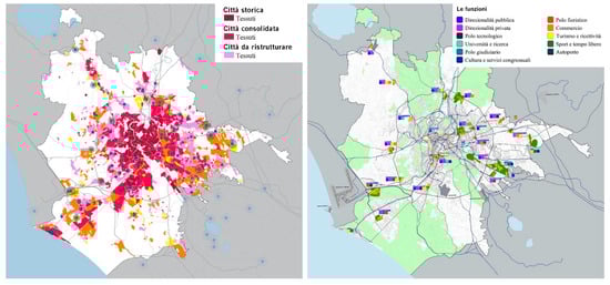
Figure 1.
On the left, PRG Rome 2003, elaboration D4 Fabrics and Centrality (Source: http://www.urbanistica.comune.roma.it/images/uo_urban/prg_adottato/d4.pdf. Accessed on 22 June 2022 ). Right, PRG Rome 2003, elaboration D5 Centrality and Functions (Source: http://www.urbanistica.comune.roma.it/images/uo_urban/prg_adottato/d5.pdf. Accessed on 22 June 2022).
To implement them, the General Regulatory Plan subdivides the centralities into those with defined planning, and centralities to be planned. “The former relate to settings for which executive urban planning instruments and intervention programmes have already been or are being approved; the latter relate to settings to be submitted to executive planning through the urban design procedure” [62]. The “urban design” procedure is initiated through the preparation of a “Preliminary organization scheme (Schema di assetto preliminare”—SAP) verifying the intervention’s environmental, morphological/functional, economic, and financial feasibility, with particular reference to the effects produced on the residential, environmental, infrastructural, social, and economic context, to the qualification of the system of public or public-use spaces, to the collective transportation network, and to vehicular, bicycle, and pedestrian mobility [64].
The implementation of the metropolitan and urban centralities is subordinated to the prior or simultaneous development of infrastructure for public transportation (underground rail lines, other systems circulating on their own infrastructure) [64]. In the data sheets contained in the appendix to the implementing technical standards, the 2008 General Regulatory Plan [65] specifies the implementation rules for each metropolitan and urban centrality to be planned.
In particular, the data sheets establish the quantity of public building, private building, and the functional mix. In accordance with the equalization-offset model introduced by the General Regulatory Plan, the gross floor area relating to the land (private GFA) is calculated as a function of the areas’ “legal status” at the moment of the Plan’s formation. Conversely, the gross floor area for the Municipality of Rome (public GFA) is completely independent of legal status, and its overall quantification depends on the strategic choices and the development programs established by the administration, subject to verification that the planned construction quantities are typologically/morphologically and environmentally compatible with the settlement’s features [61].
In fact, in keeping with the new equalization rules, the implementing technical standards establish, for “Certain Plan” components, “Compensation settings” in which a portion of additional building rights is provided to the Municipality of Rome, which will use it for purposes of public or general interest. These purposes include the urban planning offsets decided upon with: the certainties Plan; building renovation incentives that cannot be localized onsite, social residential building; offset transfer incentives that cannot be localized onsite; public or public-interest services and equipment; incentives for the private financing of public or public-interest works; and the transfer of built volumes in the ecological network, contrasting with the needs of environmental protection and requalification [66].
According to the data reported in the Appendix to the 2008 General Regulatory Plan, [65] the eight metropolitan and urban centralities have a territorial surface area of 569.2 hectares, for a total gross floor area (GFA) of 1,289,921 m2, of which 699,635 m2, or 54% of the total, is available to the Municipality of Rome (about 18,600 room equivalents) (Table 1).

Table 1.
Centralities to be planned. Construction forecasts.
2.2. The Study Area. The Acilia–Madonnetta Urban and Metropolitan Centrality
The Acilia–Madonnetta Urban and Metropolitan Centrality (Centralità Urbana e Metropolitana—CUM), located in the city’s southwestern periphery outside the ring road and about 20 km from the center, is a pole of strategic interest for the multipolar organization of the city and of the entire Acilia district, in addition to being an area of great environmental value. The Centrality, which has an area of 136.1 ha, is inserted within a much larger study area, extending about 8365 ha and having 150,000 inhabitants characterized by an uneven and unfinished settlement fabric consisting mainly of illegal fabrics and spontaneous (about 2000 ha) and from legal fabrics (about 1300 ha) built through subdivision plans of private initiative, and plans for public housing. The area is inserted in an environmental context characterized by the presence of important protected natural areas arranged in a crown around the settlement system. To the west, south, and north, the area borders, in fact, with the State Natural Reserve of the Roman Coast, and to the east, with the Presidential Estate of Castel Porziano.
The almost completely flat area located about 5 m above sea level setting consists mainly of non-productive and marginality agricultural areas and a dense network of drainage canals built starting in 1884 by Associazione Generale Operai e Braccianti del Comune di Ravenna. The canals, now almost all abandoned or in a state of decay, are of significant interest for the hydrogeological and geomorphological structure of the area, strongly structuring the intervention area (Figure 2, Figure 3 and Figure 4).
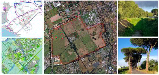
Figure 2.
Urban and Metropolitan Centrality “Acilia–Madonnetta”. Top left, D3. Mobility infrastructure (Source: http://www.urbanistica.comune.roma.it/images/uo_urban/prg_adottato/d3.pdf. Accessed on 24 June 2022). Lower left, P4. Ecological network (Source: http://www.urbanistica.comune.roma.it/images/uo_urban/prg_adottato/p4_10.pdf/. Accessed on 24 June 2022). In the center, satellite image (Source: https://www.google.it/earth/). Top right, drainage channel of Dragoncello (Source: photo by author). Bottom right, Via dei Pescatori (Source: photo by author).
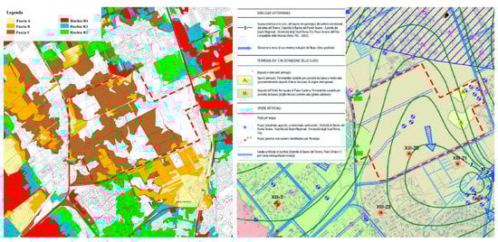
Figure 3.
Left, PAI Tiber. Tavv PB 88 I, II, III Bands and hydraulic risk on the secondary and minor network (Drainage channels of the Agro Romano) (Source: http://www.abtevere.it/sites/default/files/datisito/TAV_PB88_II.pdf. Accessed on 24 June 2022). Right, Hydrogeological map of the municipal area. G9_3_09/10. (Source: http://www.urbanistica.comune.roma.it/images/prg/ges-2008-G9_3_09.pdf; http://www.urbanistica.comune.roma.it/images/prg/ges-2008-G9_3_10.pdf. Accessed on 24 June 2022).
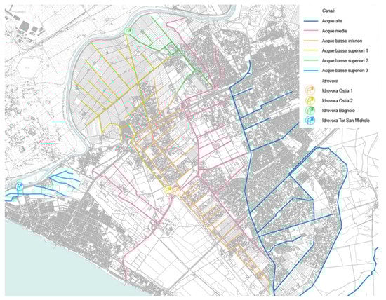
Figure 4.
Analysis of the flow senses of the drainage channels of the Agro Romano. (Source: https://qgiscloud.com/CBLN/CBLN1. Accessed on 24 June 2022. Elaborations by the author).
With reference to underground water circulation, soil permeability, hydrographic basins, and the main works that use groundwater, the hydrogeological map of the municipal territory (G9.3) classifies the areas of centrality mainly among the “Deposits of the Terraced Unit of Piana Costiera” with variable permeability, from ”low to medium-high”, in addition to identifying some industrial and agricultural wells (Figure 3). The hydrogeological plan (PAI) of the Tiber river, approved with DCRL 17/2012, identifies in the area two flood hazard bands (B and C) on the secondary network consisting of the drainage canals of the Agro Romano (Figure 3).
With reference to the mobility infrastructure system, the area is characterized by a very unstable road network, less and less capable of withstanding heavy traffic flows. In particular, the road mobility system has three radial cross-sectoral routes, Via Ostiense, Via del Mare, and Via Cristoforo Colombo, and five primary sectoral routes, Via di Malafede, Via di Acilia, Via di Macchia Saponara, Via di Casalpalocco, and Via Canale della Lingua–Via del fosso di Dragoncello (Figure 2). The infrastructure system for rail mobility is characterized by the presence of an axis that runs from the northeast to the southwest, consisting of the Rome–Lido railway (28.3 km and 13 stations), which connects the Roma Porta San Paolo station in the Ostiense district to the Cristoforo Colombo station in the coastal hamlet of Castel Fusano.
Project Data. The Equalization-Offset Model and Ecological-Environmental and Functional Endowments
The project data were obtained from the data sheets reported in the Appendix to the implementing technical standards of the General Regulatory Plan [65]. In keeping with the equalization-offset model adopted by the General Regulatory Plan, they establish the total, buildable Gross Floor Area (GFA) of 351,582 m2, of which 157,408 m2 destined for private individuals and 194,174 m2 for interventions of public and general interest (Table 2). As to the functional mix, the regulations provide for assigning 60% of the GFA to executive, tertiary, and service functions on an urban or metropolitan level, or 210,949 m2, an amount equal to 20% of the GFA for residence, for 70,316 m2, while the remaining 20% of the GFA (70,316 m2) constitutes the flexible share to be attributed during implementation (Table 3). As to the ecological-functional division of the Land Surface Area (LSA), equal to 1,361,662 m2, the regulations of the General Regulatory Plan developed by this author provide for a Construction Concentration Area (Area di concentrazione edilizia—ACE) equalling 25% (340,416 m2), Private green area with ecological value (Verde privato con valenza ecologica—Ve) equalling 5% (68,083 m2), Areas transferred for green services, car parks, ecological/environmental and functional endowments (Aree cedute per verde servizi, parcheggi, dotazioni ecologico-ambientali e funzionali—Vp) equalling 60% (816,997 m2), plus areas for road beds and exchange node (sedi viarie e nodo di scambio—Str) equalling indicatively 10% (136,166 m2) (Table 4).
Table 2.
Total building rights.
Table 3.
Admitted intended uses.
Table 4.
Ecological-functional breakdown (LSA).
The urban-ecological parameters referred to in the implementing technical standards of the General Regulatory Plan provide for a permeability index (IP) > 30% for ACE + Ve; greater than 90% in Vp areas; an arboreal density (DA) equal to 40 trees / ha and a shrub density (DAR) equal to 60 shrubs/ha to be calculated over the entire St with the exception of areas destined for urban forestation where a much higher tree density is expected [37]. The equalization-offset model also establishes an equal division of land surface area (LSA) into two categories of land, in proportion to the percentage of areas transferred: the former reserved for owners (proprietà—Prp) and the latter for the municipality (Prc). Consequently, the ACE reserved for owners equals 152,409 m2 while the public ACE equals 188.007 m2.
2.3. The Methodology
The contribution adopts an integrated and inter-scalar methodology, divided into phases, iterative and interconnected, corresponding to the synthetic recomposition of the themes investigated around three disciplinary needs: a need to contextualize the framework of the approaches and the main theoretical-disciplinary contributions, a need of operation and interpretation of the results obtained, consisting of the analysis of the case study, and a need for critical and proactive reflection.
With these purposes, the methodological approach underlying the project simulates a planning process for part of the X Municipality divided into three levels, Director Scheme, Local plan, and Urban Project (Figure 5), with the aim of prefiguring the construction of a GI characterized by new ecological-environmental and functional endowments strictly related to the promotion of an efficient, smart, and green city. The methodological process assumes, for each level, a theoretical subdivision into four main phases, which are also highly interactive: cognitive deepening; interpretation–evaluation; the clarification of the objectives; and the identification and coherence of strategies and actions for the pursuit of objectives [67]. The contribution, which specifically explores the third level of the methodological structure (Urban Project), highlights the potential and limits of the proposed experimentation, relating both to the quality and innovation of design solutions and possible evolutionary lines and to the lack of clear institutional governance that is limiting the implementation of projects.
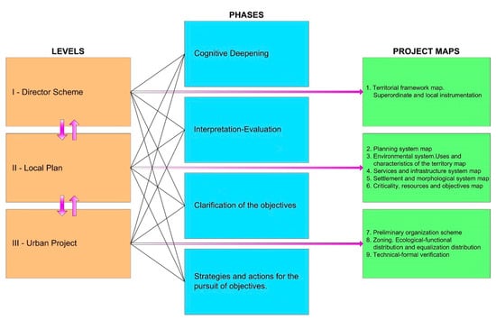
Figure 5.
Methodological structure of the project. (Source: elaboration by author).
2.4. The Design. A Green Infrastructure for the Acilia–Madonnetta Centrality
Working within this frame of theoretical, methodological, and operative reference is the design exercise conducted in the Urban Design Workshop of the Rome Faculty of Architecture (2021–2022 Academic Year) held by the author, which develops an integrated, multidisciplinary approach aimed at producing high levels of urban and environmental quality, energy efficiency, and circularity of resources.
In particular, the design developed by the group of students—Stefano Maiorano, Francisco Javier Moran, Agnese Musto, and Carlotta Paloni—provided the opportunity to experiment with disciplinary innovation in a tangible way, with particular reference to the construction of a GI characterized by new ecological functional endowment closely correlated with the promotion of an efficient, smart, and green city.
Starting from the guidelines and prescriptions of the 2008 General Regulatory Plan, the exercise focuses on the design of the Acilia–Madonnetta Urban and Metropolitan Centrality (CUM), one of the new poles of the large-scale reorganization of the Roman periphery able to guarantee the triggering of virtuous regeneration processes, while involving the different dimensions (environmental, social, and economic) of sustainability. In keeping with the traits of the new strategy of ecological/environmental regeneration, the design proposal aims at guaranteeing a drastically reduced introduction of climate-altering substances, ensuring high levels of energy self-sufficiency, and mitigating the effects caused by climate change. This is to take place by employing eco-friendly technologies and nature-based materials, recycling and reusing resources, using systems to generate energy from renewable sources, developing a low-environmental-impact transportation network, and strengthening bicycle and pedestrian mobility (Figure 6).
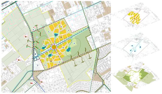
Figure 6.
Rome Municipality X, Urban and Metropolitan Centrality Acilia–Madonnetta. Urban project. Preliminary organization scheme. (Source: elaborations by the students: S. Maiorano, F. J. Moran, A. Musto, C. Paloni, Urban Planning Laboratory of the Faculty of Architecture of Rome A.A. 2021–2022).
In relation to the new operative and management model, the implementation/equalization mechanisms integrated with the new regeneration strategy foster the design’s self-sustainability capacity over the medium–long term by implementing a policy of “compatible socialization of real estate” [68]. This approach promotes the construction of the public city as the primary structure of reference for a new urban welfare, a “space for citizenship, community, and cohesion” [69] guaranteeing rights enshrined since the 1960 s and 1970 s: to education, to health, to housing, to public mobility, and to social housing. In this perspective, the design calls for developing infrastructure for sustainable mobility (ecological tram, bike/pedestrian paths, electric vehicle recharge stations, parking for cars, scooters, and bike sharing), and public greenery, in addition to the development of multifunctional and adaptive services (Figure 7), capable of activating policies for training, work, and social inclusion (business incubators, coworking, fablab, business centers, etc.).
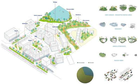
Figure 7.
Rome Municipality X, Urban and Metropolitan Centrality Acilia–Madonnetta. Urban project. Volumetric plan of an urban sector. (Source: elaborations by the students: S. Maiorano, F. J. Moran, A. Musto, C. Paloni, Urban Planning Laboratory of the Faculty of Architecture of Rome A.A. 2021–2022).
With reference to the need to restore the bonds between physical continuity, form, and cultural identity [70], the design pays particular attention to protecting and enhancing the permanent elements (diffuse, historic, cultural, and archaeological), and to relationships with the surroundings in terms of accessibility and consistency with the existing settlement trajectories and with the objectives of eco-sustainability.
The settlement structure is divided into four sectors by a main axis in an east–west direction and by a counter axis in a north–south direction, which take up and enhance the texture of the existing drainage canals (Figure 6). The settlement structure’s design was strongly influenced by the Casalpalocco parceling Plan, designed in the late 1950 s by Adalberto Libera and Ugo Luccichenti, among others, and located south of Centrality. This choice may be seen above all from the design of the road scheme, marked by distribution rings to the individual sectors whose carriageways are separated by a strip of green planted with trees, functioning as a “park road” (Figure 8).
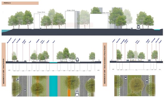
Figure 8.
Rome Municipality X, Urban and Metropolitan Centrality Acilia–Madonnetta. Urban project. Profiles. (Source: elaborations by the students: S. Maiorano, F. J. Moran, A. Musto, C. Paloni, Urban Planning Laboratory of the Faculty of Architecture of Rome A.A. 2021–2022).
With reference to the construction of the public city as an engine of sustainable development and of environmental regeneration of essential resources, the design exercise is set within the context of Community and international policies for sustainable development [6,10] to combat climate change [11], and for the promotion of green infrastructure [19]. This converges with the need to implement urban regeneration interventions based on new cognitive paradigms, such as ecosystem services [71], new design metaphors based on adaptive and resilient strategies, new strategies for efficiency and the circularity of resources, and adaptation to and mitigation of climate change, also through integrated actions of reconnection and reconfiguration of the environmental components.
In this framework, the design hypothesis, taking inspiration also from certain international, ecologically oriented, urban-scale planning experiences (Hammarby Sjöstad 1996, Kronsberg 2000, Vauban 2006, Clichy-Batignolles 2016) [51,52,53], heralds new environmental devices related to the urban water cycle, such as bioswales, water squares, and four biolakes (Figure 9), and areas destined for activities connected to managing the waste cycle and generating renewable energy from alternative sources, such as an ecological island and a biogas plant.
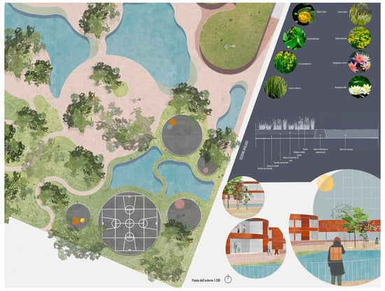
Figure 9.
Rome Municipality X, Urban and Metropolitan Centrality Acilia–Madonnetta. Urban project. Bio-lake. (Source: elaborations by the students: S. Maiorano, F. J. Moran, A. Musto, C. Paloni, Urban Planning Laboratory of the Faculty of Architecture of Rome A.A. 2021–2022).
In particular, bioswales are vegetation-rich spaces that strengthen the settlement structure’s main axes, designed to reduce the speed of surface runoff and, along with biolakes, to constitute a system to collect, purify, and recycle rainwater. The four biolakes are artificial lakes safe for swimming that are integrated with the natural environment and use a system of plant-based purification, thus allowing the existing water balance to be preserved and biodiversity to increase, while functioning as microclimate regulators. The water squares [72] are multifunctional public spaces which, through careful planning, in the event of heavy rains and extreme climatic events, are transformed into rainwater collection and storage basins, with the aim to ease the pressure on the sewage system and to reuse stored water in periods of drought and water stress.
The biogas-fueled co-trigeneration plant produces energy (electric, thermal, and refrigerating, as well as biomethane) from organic plant material, from animal effluent, and from organic waste (organic fragment of solid urban waste—FORSU), which is introduced into a district heating and cooling network servicing the settlement and the adjacent neighborhoods (Figure 10). In particular, among the other benefits, the upgrading of biomethane biogas is, in the current geopolitical crisis that requires speeding the energy transition processes, a technology of great interest, because in addition to being an alternative to fossil methane, it allows biomethane to be introduced into the gas network.
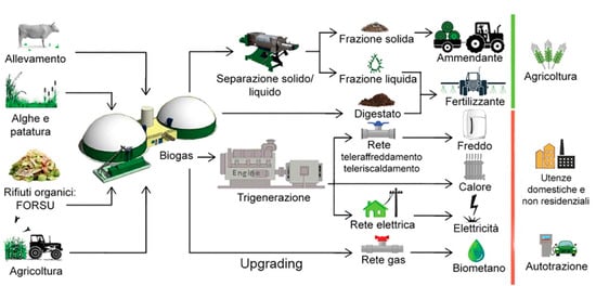
Figure 10.
Operation diagram of the co-trigeneration plant fueled by biogas. (Source: Degree thesis by Agnese Ricciardelli. A.A. 2018–2019. Thesis supervisor F. Crupi).
Within the Centrality, an area equal to 10.7 ha is planned for forests with a high natural value, mixed trees and shrubs of autochthonous species, “unevenly destined for multiple roles of ecological-environmental enhancement and mitigation” [73]. In particular, the project will use the new SRF plants as a filter and compensation function, for example, for a co-trigeneration plant [73]. The design is complete with the establishment of an “ecological district” consisting of three large non-productive agricultural areas located at the margins of the Centrality, and an area inside. In addition to the biogas plant, the district is conceived to accommodate high-density and rapid-growth biomass energy plantations to be destined mainly for energy transformation. This “urban reforestation” design can increase the ecosystem functionality of GI, contribute towards reducing greenhouse emissions, improving the microclimate, and mitigating pollution, and function as a carbon sink (Figure 11).
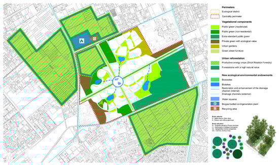
Figure 11.
Rome Municipality X, Urban and Metropolitan Centrality Acilia–Madonnetta. Urban project. The green system and reforestation. (Source: elaborations by the students: S. Maiorano, F. J. Moran, A. Musto, C. Paloni, Urban Planning Laboratory of the Faculty of Architecture of Rome A.A. 2021–2022).
3. Results
3.1. Sizing and Functional Destinations
The project envisages a residential GFA equal to 140,633 m2 (40% of the total GFA) of which 60,000 m2 is intended for social housing to settle a total of 3750 inhabitants, and the remaining part of the GFA, equal to 210,949 m2, is for nonresidential use. In line with the planning guidelines of the 2008 General Regulatory Plan, which promote the inclusion in the Centrality of innovative functions capable of triggering processes of regeneration of the periphery and decongestion of the historic center, the project envisages, in compliance with the rules provided for by the new equalization-offset model, among other destinations, the construction of a university center, a city of music, a media library, a cultural center, a citadel of craftsmanship, and a courthouse, functions strongly shared by local communities (Table 5). In the areas intended for public services, in addition to the construction of a “community house” [74], with the function of a proximity hub for primary care and for social and welfare support, the project includes workshops to raise awareness of climate change issues, recycling and new forms of energy, and spaces for multifunctional and adaptive services, capable of activating policies for training, work, and social inclusion.
Table 5.
Hypothesis of distribution of the functional mix.
3.2. The Environmental System
3.2.1. The New Ecological-Environmental and Functional Endowments
In line with the characteristics of the ecological-environmental regeneration strategy and the new equalization-offset model, at the end of the project, the Centrality will be able to count on an overall patrimony of public areas, obtained through free transfer equal to 117.2 ha, approximately 86.0% of the LSA (136.2 ha), of which 36.6 is for green areas and public services, 10.0 for environmental endowments, bioswales, waters squares, and bio-lakes, 7.1 for ground level and multistory parking, 3.8 for private green areas with ecological value, 6.0 for urban gardens, 25.0 for Short Rotation Forestry (SRF), 12.9 for interchange and roads (over 6.5 km of cycle and pedestrian paths), and 18.8 ha (public Ace) destined for purposes of public or general interest (Table 6) equal to a land area of 194,174 m2, equivalent to 55.2% of the total land area (351,582 m2).
Table 6.
Total assets of public areas, obtained through free transfer.
3.2.2. Permeability of Soils and Urban-Ecological Dimensions
With reference to the rules on the permeability of soils and, more generally, the respect of the urban-ecological parameters contained in the Implementing technical standards of the Prg 2008, at the end of the project, the permeable surface will be equal to 88.3 ha, approximately 64.8% of the St. In the Central area, over 4448 trees with a trunk diameter between 20 and 30 cm and 6672 shrubs will be planted, with the exception of areas destined for urban forestation.
Urban-ecological dimensions
IP (ACE + VE) > 30%
IP = 408.499 × (100/30) = 122.550 m2
IP (Vp) > 90%
IP = 567.381 × (100/90) = 510.643 m2
Surface Short Rotation Forestry = 249.616 m2
Total permeable surface = 882.809 m2
Tree and shrub density
DA (ST − SRF) = 40 trees/ha
N. trees = 111.20 × 40 = 4.448
DAR (ST − SRF) = 60 shrubs/ha
N. shrubs = 111.20 × 60 = 6.672
3.2.3. The Ecological District
The Centrality project provides for the establishment of an “Ecological district” aimed at launching new green economies. The district is mainly located outside the Centrality with an area of 163.7 hectares (of which 25.0 are inside the Centrality). In addition to a biogas-fueled co-trigeneration plant and a recycling area for a total of 40,000 m2, it includes abandoned or degraded agricultural areas for a total area of 159.7 ha. The project plans to allocate the largest part of these areas, equal to 131.7 ha, to new productive and energy trees (SRF), using fast-growing forest species, with the absence of chemical treatments, a tree density equal to 1500 trees/ha, and intensive management compared to traditional silvicultural systems [37]. Cutting will take place 1–15 years after planting [37]. The most suitable species for the Roman territory are willows (Salix spp.), black locust (Robinia spp.), and poplar (Populus spp.), species able to regenerate quickly from the stump after cutting. Overall, approximately 200,000 trees will be planted by the end of the project. The production of energy from renewable energy sources (RES) (electrical, thermal, refrigeration, and biomethane) will be powered by the humid fraction of municipal waste (FORSU), animal waste, algae, ordinary maintenance mowing, and biomass from the energy forestation of a new plant. The remaining part of the ecological district, equal to 28 ha, will be destined to forests with a high natural value necessary to act as a compensation filter for the co-trigeneration plant and for the new SRF plants. These areas will be designed with an arboreal density of 70 trees/ha and a shrub density of 200 shrubs/ha, corresponding to the planting of a further 2000 trees and 5600 shrubs [73]. The provision of an extensive amount of area intended for urban forestation is of strategic importance for the implementation of productive systems functional to a new and more efficient urban metabolism.
3.2.4. The Ecological and Environmental Benefits
The Centrality project favors the pursuit of substantial ecological and environmental benefits such as the protection of biodiversity, the improvement of fundamental resources (air, water, and soil), and more generally, the quality of life of citizens. In particular, this involves the correct planning of public and private green areas, of forests with a high natural value, and of forests for energy and production purposes (SRF), through the appropriate choice of tree species and their correct insertion into the settlement system, as well as optimizing the costs of planting and maintenance and their contribution (due to their ability to fix dust, toxic gases, greenhouse gases, and release oxygen) to the reduction in climate-altering emissions, to the improvement of the local microclimate, to the maintenance and enrichment of biodiversity, to the mitigation of atmospheric and acoustic pollution, to the improvement of the functionality and ecological connectivity of the urban and peri-urban landscape, and to the creation and/or completion of the municipal ecological network [36].
Overall, the land inside the central area used for environmentally compatible uses amounts to 86.7 ha, equal to 63.7% of LSA. In particular, public green areas (standard and extra standard) amount to 28.7 ha, urban gardens to 6 ha, and the canal, the bioswales, the water squares, and the bio-lakes to 10 ha (Table 7). In the project, the restoration and enhancement of the existing drainage canal together with the construction of four new bio-lakes favor a sustainable and resilient use of the water resource, making it possible to achieve important environmental benefits such as the mitigation of the heat island effect, stability and the good hydraulic regime of the land, the fertility of the soil, the water runoff, the purification of water, and the increase in biodiversity. Finally, the production of bioenergy derived from biomass provides a valid alternative to the use of fossil fuels, presenting positive effects on water resources, soil, biological diversity, and the landscape [75].
Table 7.
Soil (inside the CUM) used for environmentally compatible uses.
3.2.5. The Resources That Can Be Activated. Ordinary (and Extraordinary) Charges
The Centrality will be able to activate resources deriving from ordinary concessionary charges to be used for the construction of public works equal to EUR 112.0 million. Currently, the implementing technical standards of the Prg 2008 do not provide for the payment to Rome from the “Extraordinary Urbanization Contribution”, an extraordinary concession fee aimed at the most significant real estate valuations generated by the Prg forecasts compared to the pre-existing urban planning regulations, as the quantification index of the GFA private does not exceed 0.1156 m2/m2 [62]. However, a desirable modification of this rule, supported by reasons of fairness and self-sustainability of the project to the extent of minus 20%, would bring in, for the same building surface, an additional EUR 8.4 million.
3.3. The Mobility System
Pursuant to the implementing technical standards of the Prg ‘08, the implementation of the Centrality is subject to the prior or simultaneous construction of infrastructure for public transport, subway lines, and other systems in-house. For these purposes, the project, extended to the entire urban sector, in line with the objectives set by the Prg, provides for five lines of intervention (Figure 12).
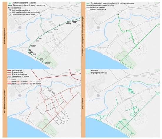
Figure 12.
Rome Municipality X (Part), Local plan. System of infrastructures. Top left, underground network; top right, public transport corridors in their own premises; bottom left, road traffic; bottom right cycle-pedestrian paths (Source: elaborations by the students: S. Maiorano, F. J. Moran, A. Musto, C. Paloni, Urban Planning Laboratory of the Faculty of Architecture of Rome A.A. 2021–2022).
- The first promotes the transformation of the Rome–Lido line into a subway through the construction of five new stations, investments in infrastructure on rolling stock and technologies, and the extension of the line from Dragona station to Fiumicino airport.
- The second involves the construction of two important corridors reserved for public transport, which play the role of supply systems to the interchange nodes of the underground lines and railways. The first, A8, (Colombo–Eur Fermi), develops in a northeast–southwest direction, connecting the Eur to the Roman coast; the second, A6 (Infernetto–Nuova Fiera di Roma), develops in a north–south direction, connecting the area of the new Fiera di Roma and Acilia, north of the urban sector, with the southern part in the Infernetto settlement, crossing the Centrality, and reconnecting to the north with the future new metro line. The corridors reserved for surface public transport are made up of new transport systems with low environmental impact that involve multiple surface transport systems, such as light subways, trams, and buses, characterized by advanced technologies in propulsion, driving, and transport systems information.
- The third envisages a general redefinition and strengthening of the road network and interchange nodes, also through measures to mitigate the impacts on urban roads and to moderate traffic.
- The fourth involves the reconfiguration of soft mobility systems (cycle and pedestrian paths, urban and environmental use paths) with the aim of creating a cycle mobility network, which today, although present in some neighborhoods, is fragmented and discontinuous.
- The fifth guideline, in line with the objective of creating a low environmental impact road transport system and encouraging electric mobility, envisages the construction of 150 new electric charging stations [76], and to extend car, scooter, and bike sharing systems for the entire urban sector.
3.4. The Objectives of Public and General Interest
The Centrality project aims to achieve some objectives of public and general interest. In particular, in the public ACE (188,007 m2), through the application of mechanisms for the transfer of building rights [77], the resulting GFA will be able to achieve: from the compensation of the “Certain Plan” for 59,487.5 m2 (Table 8 and Table 9), from urban renewal interventions for 24,854.0 m2, from social housing interventions for 60,000.0 m2, from the transfer of volumes built in the ecological network for 41,832.5 m2, and 8000.0 m2 deriving from the compensatory transfer mechanism (Table 8) (Figure 13). Consequently, areas destined for green areas, services, and the Agro Romano, outside the centrality, for a total of 690,483 m2 (Table 10) (Figure 14) may be acquired for public assets.
Table 8.
Hypothesis of distribution of the public GFA.
Table 9.
Compensation hypothesis (“Certain Plan”).
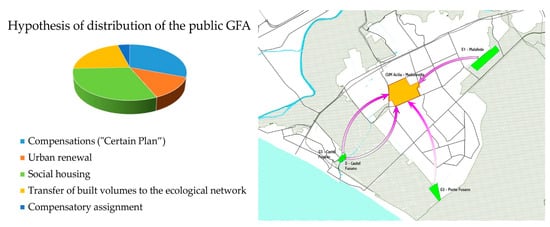
Figure 13.
Left. hypothesis of distribution of the public SUL. Right. Compensations (Variant of Certainties) (Source: elaborations by the author).
Table 10.
Hypothesis of areas acquired for public assets (outside CUM) destined for green areas services and the Agro romano.
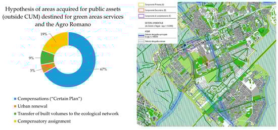
Figure 14.
Left. Hypothesis of areas acquired for public assets (outside CUM) destined for green areas services and the Agro Romano (Source: elaborations by the author). Right. Transfer of built volumes to the ecological network. (Source: elaborations by the author; P4. Ecological network: http://www.urbanistica.comune.roma.it/images/uo_urban/prg_adottato/p4_10.pdf/).
4. Discussion
The Centrality design was developed in each of its components, producing highly commendable and encouraging results from the standpoint of a sustainable, resilient planning aimed at producing high levels of quality in terms of settlement, environment, energy efficiency, and circularity of resources.
Compared to the design hypotheses presented for this and other centralities of the Municipality of Rome, such as the Anagnina–Romanina centrality, designed by the Portuguese architect Manuel Salgado [78,79], the results obtained prove to be of great interest, in particular with respect to the ecological-environmental benefits that can be reached and the achievement of the objectives of public and general interest.
Almost all the projects submitted to the Capitoline administration for evaluation, in fact, are characterized by a very flexible and incoherent interpretation of the rules of the General Regulatory Plan, on the continuous demand by ownership for an increase in the quantities of private constructions, and consequently for a diminishment of public building rights; for a different functional mix towards residential functions; and for a functional dequalification of the public transportation systems. These are demands that would have devastating effects on the Centralities’ implementation. A different division between the public GFA and private GFA and the densification of the Centralities would in fact thwart the equalization mechanisms conceived to foster the objectives of urban requalification and protection of the environment and landscape, which consider the entire territory of the Municipality of Rome.
The study illustrated is continuous and consistent with the “eco-districts” projects carried out in recent years in Europe and with the risk mitigation and climate adaptation strategies focused on the use of renewable energy sources, on cycle management of water and waste, and on the quality of the physical, economic, and social relationships that guarantee the rooting of transformations in the environment [80]. At the same time, it presents the terminological-definitional and content uncertainties that characterize the current scientific debate in relation to the different approaches used, the empirical evidence of the results, and the environmental and socio-economic impacts [51,52]. In this context, the produced items do not completely address the entire set of problems that the intervention presents, raising the need to more deeply examine additional and strongly interrelated prospects for research:
- an initial line of research relates to the possibility of calculating the Ecosystem Services (ESs) offered upon the project’s outcome. Starting from the quantity and distribution of uses and of land coverages as gleaned from the design for the Centrality and for the ecological District, the use of specialist software allowed certain ESs, such as water yield (WY), carbon sequestration (CS), and habitat quality (HQ) to be analyzed—thus providing average biophysical values and mappings representing the soil’s biophysical performance [81,82];
- A second line of research might examine in greater depth the technical, regulatory, and economic aspects, in Italy and abroad, relating to the prospects of feasibility and the environmental and economic objectives that may be achieved through the development of biogas plants. This field of multidisciplinary research is an extremely interesting one, because the production of fuel and energy from renewable energy resources marks a fundamental step towards responding to the needs of decarbonizing energy systems and towards containing the effects of global warming.
- A third line of research, also multidisciplinary, might examine the technical, regulatory, and economic aspects, in Italy and abroad, relating to the prospects of feasibility and the environmental, landscape, social, and economic objectives that can be achieved through the development of urban reforestation systems. This field of research regards plantings of trees for wood, medium- and long-cycle, replanting, and sylviculture, and for the creation of urban and periurban forests, as defined in the national urban greenery strategy [35], taking account—as criteria for selecting the designs—of the environmental and social value, the level of requalification and usability, and the levels of air quality [34].
In short, the calculation of ecosystem performance, the production of bioenergies, reforestation and the recovery of degraded lands can be fields of research dense with prospects for building new physical and intangible arrangements and configurations capable of raising the levels of residential and environmental quality, social inclusion, and economic growth.
5. Conclusions
The contribution had the objective of demonstrating how the multiscalar and multidimensional construction of the “Acilia–Madonnetta” Urban and Metropolitan Centrality (Centralità Urbana e Metropolitana—CUM), supported by new inclusive, sustainable, and resilient design metaphors, in keeping with the processes of technological innovation and of multidisciplinary integration, can ensure the ecological quality of urban environments, more sustainable, efficient, and safer transport, and the elimination and recycling of waste, activating regenerative processes capable of transferring to the city, as a whole, the social, economic, and ecological/environmental benefits that these interventions bring with them. However, in spite of the substantial elements of disciplinary and procedural innovation contained in the approach to regeneration outlined in the General Regulatory Plan, the lack of a clear institutional governance and of sufficient public financing in the enduring recession of the real estate market, as well as a hypertrophic bureaucracy, are hindering the Centralities’ implementation.
Fourteen years after the approval of the General Regulatory Plan, of the eight Centralities to be planned, only for the “Santa Maria della Pietà” Urban Centrality has the preliminary organization scheme (Schema di Assetto Preliminare—SAP) been approved [83]. In so uncertain and confused a setting, other considerations are added that may provide additional opportunities for debate, dialogue, and experimentation. These relate to:
- the need—one that can no longer be put off—to approve a national framework law of principles, necessary in order to homogenize and streamline the regional laws, to set out the policy of the services of the public city and of the territorial endowments [84], and to create a system of programs of government and community initiative, implementation mechanisms, and forms of withdrawal of urban income, restoring value and meaning to the construction of a new welfare model;
- the ability of public administrations to rediscover that urban planning and design continuity constituting political alternations, without which it is impossible to guarantee implementation of the programs and projects already started;
- integration of physical regeneration interventions with employment and training policies aimed at socioeconomic development and social inclusion;
- the introduction of new modes of financing of public works able to intercept the vast array of resources, in a national and community setting, that are put into play above all in the issues of sustainability, energy and digital transition, fighting climate change, and resilience, such as those set out by the Green New Deal [12], or deriving from post-pandemic recovery programs [73].
These considerations require a decisive change of pace calling for the radical streamlining of bureaucratic and urban planning/building procedures, and the strengthening of technical structures, new planning, organizational, and management models capable of preventing the inefficiencies of the past. They require grappling with complexity, reducing inequalities, conflicts, and divisive dynamics, and promoting future visions in line with the new challenges of the contemporary world, helping the construction of inclusive, sustainable, and climate-proof cities.
Funding
This research received no external funding.
Institutional Review Board Statement
Not applicable.
Informed Consent Statement
Not applicable.
Data Availability Statement
Not applicable.
Conflicts of Interest
Author declares no conflict of interest.
References
- Ricci, L. Governare la città contemporanea. Riforme e strumenti per la rigenerazione urbana. Urbanistica 2018, 160, 91–95. [Google Scholar]
- IPCC. Climate Change 2014: Global and Sectoral Aspects; IPCC: Geneva, Switzerland, 2014; Available online: https://www.ipcc.ch/site/assets/uploads/2018/02/WGIIAR5-PartA_FINAL.pdf (accessed on 20 June 2022).
- IPCC. Climate Change 2021: The Physical Science Basis. In VI Assessment Report of the Intergovernmental Panel on Climate Change; Cambridge University Press: Cambridge, UK, 2021; Available online: https://www.ipcc.ch/report/ar6/wg1 (accessed on 20 June 2022).
- Becchetti, L.; Conzo, G.; Conzo, P.; Salustri, F. Understanding the Heterogeneity of Adverse COVID-19 Outcomes: The Role of Poor Quality of Air and Lockdown Decisions 2020. Available online: https://papers.ssrn.com/sol3/papers.cfm?abstract_id=3572548 (accessed on 20 June 2022).
- United Nations. Conferences | Environment and sustainable development. In Proceedings of the Conference on Environment and Development (UNCED), 1992, Rio de Janeiro, Brazil, 3–14 June 1992. Available online: https://www.un.org/en/conferences/environment/rio1992 (accessed on 21 June 2022).
- United Nations. Agenda for Sustainable Development. 2015. Available online: https://www.un.org/ga/search/view_doc.asp?symbol=A/RES/70/1&Lang=E (accessed on 22 June 2022).
- United Nations. Sendai Framework for Disaster Risk Reduction 2015–2030. 2015. Available online: https://www.undrr.org/publication/sendai-framework-disaster-risk-reduction-2015-2030 (accessed on 22 June 2022).
- Galderisi, A. Cambiamento climatico, rischi e governo delle trasformazioni urbane: Quali prospettive per l’integrazione? Urban. Inf. 2014, 257, 50–53. [Google Scholar]
- European Commission. Urban Agenda for the EU, Pact of Amsterdam. 2016. Available online: https://ec.europa.eu/regional_policy/sources/policy/themes/urban-development/agenda/pact-of-amsterdam.pdf (accessed on 30 June 2022).
- European Commission. Europa 2020. In A Strategy for Smart, Sustainable and Inclusive Growth, COM (2010) 2020 Final; European Commission: Brussels, Belgium, 2010. Available online: https://eur-lex.europa.eu/legal-content/EN/TXT/PDF/?uri=CELEX:52010DC2020&from=IT (accessed on 23 June 2022).
- United Nations. Paris Agreement (UNFCCC). 2015. Available online: https://unfccc.int/sites/default/files/english_paris_agreement.pdf (accessed on 23 June 2022).
- European Commission. Green Deal Europeo. In Communication from the Commission to the European Parliament, the European Council, the Council, the European Economic and Social Committee and the Committee of the Regions; COM (2019) 650 final; European Commission: Brussels, Belgium, 2019. Available online: https://eur-lex.europa.eu/legal-content/EN/TXT/PDF/?uri=CELEX:52019DC0640&from=IT (accessed on 20 June 2022).
- European Commission. Forging a climate-resilient Europe—the new EU Strategy on Adaptation to Climate Change. 2021. In Communication from the Commission to the European Parliament, the European Council, the Council, the European Economic and Social Committee and the Committee of the Regions; COM (2021) 82 final; European Commission: Brussels, Belgium, 2021. Available online: https://eur-lex.europa.eu/legal-content/EN/TXT/PDF/?uri=CELEX:52021DC0082&from=IT (accessed on 27 June 2022).
- United Nations. Glasgow Climate Pact. 2021. Available online: https://unfccc.int/sites/default/files/resource/cma2021_10_add1_adv.pdf (accessed on 1 July 2022).
- Poli, I.; Uras, S. Pianificare le infrastrutture verdi in ambito urbano. Il caso spagnolo di Vitoria-Gasteiz. Urban. Doss. Line 2018, 15, 228–231. [Google Scholar]
- Galuzzi, P.; Vitillo, P. Città contemporanea e rigenerazione urbana. Temi, azioni, strumenti. Equilibri 2018, 22, 125–133. [Google Scholar]
- Gabellini, P. La Rigenerazione Urbana Come Resilienza. In Proceedings of the XXVIII Congresso Nazionale INU, Salerno, Italy, 24–26 October 2013; Available online: www.inusalerno2013.it.
- European Commission. Fit for 55′ delivering the EU’s 2030 Climate Target on the way to climate neutrality. In Communication from the Commission to the European Parliament, the European Council, the Council, the European Economic and Social Committee and the Committee of the Regions; COM(2021) 550 final; European Commission: Brussels, Belgium, 2021. Available online: https://eur-lex.europa.eu/legal-content/EN/TXT/PDF/?uri=CELEX:52021DC0550&from=IT (accessed on 20 June 2022).
- European Commission. Building a Green Infrastructure for Europe. 2013. Available online: https://ec.europa.eu/environment/nature/ecosystems/docs/green_infrastructure_broc.pdf (accessed on 22 June 2022).
- European Commission. Towards an EU Research and Innovation Policy Agenda for Nature-Based Solutions & Re-Naturing Cities; Final report of the Horizon 2020 expert group on ‘Nature-Based Solutions and Re-Naturing Cities’ (full version), Publications Office; European Commission: Brussels, Belgium, 2015. Available online: https://data.europa.eu/doi/10.2777/479582 (accessed on 21 June 2022).
- European Commission. Our life insurance, our natural capital: An EU biodiversity strategy to 2020. In Communication from the Commission to the European Parliament, the European Council, the Council, the European Economic and Social Committee and the Committee of the Regions; SEC(2011) 244 final; European Commission: Brussels, Belgium, 2011. Available online: https://eur-lex.europa.eu/legal-content/EN/TXT/PDF/?uri=CELEX:52011DC0244&from=IT (accessed on 21 June 2022).
- Bennett, G. Towards a European Ecological Network; EECONET, Institute for European Environmental Policy: Arnhem, The Netherlands, 1991; ISBN 9074095011. [Google Scholar]
- Direttiva 92/43/CEE Habitat (1992). Conservazione Degli Habitat Naturali e Seminaturali e Della Flora e Della Fauna Selvatiche. Available online: https://eur-lex.europa.eu/legal-content/IT/TXT/PDF/?uri=CELEX:31992L0043&from=DE (accessed on 23 June 2022).
- Maggio, M. Invarianti Strutturali Nel Governo Del Territorio; Firenze University Press: Florence, Italy, 2014. [Google Scholar]
- Guccione, M.; Peano, A. (Eds.) Gestione Delle Aree di Collegamento Ecologico-Funzionale. Indirizzi e Modalità Operative per L’adeguamento Degli Strumenti di Pianificazione del Territorio in Funzione Della Costruzione di Reti Ecologiche a Scala Locale; Manuali e Linee Guida 26/2003; APAT: Rome, Italy, 2003. [Google Scholar]
- MEA—Millennium Ecosystem Assessment (Program). Ecosystem and Human Well-Being: A Framework for Assessment; Island Press: Washington, DC, USA, 2005. Available online: http://pdf.wri.org/ecosystems_human_wellbeing.pdf (accessed on 20 June 2022).
- Costanza, R. The Value of the World’s Ecosystem Services and Natural Capital. Nature 1999, 387, 253–260. [Google Scholar] [CrossRef]
- Poli, I.; Ravagnan, C. Trame verdi e blu: Verso un futuro affidabile tra visione strategica e gestione dei rischi. Urbanistica 2017, 69, 141–150. [Google Scholar]
- Gasparrini, C. In the City on the Cities; List: Trento, Italy, 2015. [Google Scholar]
- Gasparrini, C.; Terracciano, A. Dross City. Metabolismo urbano e progetto di riciclo dei drosscape; List: Trento, Italy, 2017. [Google Scholar]
- Clapp, J.A. The City: A Dictionary of Quotable Thoughts on Cities and Urban Life; Transaction New Brunswick: London, UK, 2014. [Google Scholar]
- Woods Ballard, B.; Kellagher, R.; Martin, P.; Jefferies, C.; Bray, R.; Shaffer, P. The SuDS Manual; Ciria: London, UK, 2015. [Google Scholar]
- Legge 14 Gennaio 2013, n. 10 Norme Per lo Sviluppo degli Spazi Verdi Urbani. (13G00031) (GU Serie Generale n. 27 del 01-02-2013). Available online: https://www.gazzettaufficiale.it/eli/id/2013/02/01/13G00031/sg (accessed on 20 June 2022).
- Decreto del MATTM 9 Ottobre 2020 Recante Modalità per la Progettazione degli Interventi di Riforestazione di cui alla Legge 12 Dicembre 2019, n. 141 (legge Clima). Available online: https://www.gazzettaufficiale.it/eli/id/2020/11/11/20A06097/sg (accessed on 23 June 2022).
- Ministero dell’Ambiente e Della Tutela del Territorio e del Mare. Comitato per lo Sviluppo del Verde. Strategia Nazionale del Verde Urbano. Foreste Urbane Resilienti ed Eterogenee per la salute e il Benessere dei Cittadini. 2018. Available online: https://www.mite.gov.it/sites/default/files/archivio/allegati/comitato%20verde%20pubblico/strategia_verde_urbano.pdf (accessed on 30 June 2022).
- Mirabile, M.; Bianco, P.M.; Silli, V.; Brini, S.; Chiesura, A.; Vitullo, M.; Ciccarese, L.; De Lauretis, R.; Gaudioso, D. Linee Guida per la Forestazione Urbana Sostenibile di Roma Capitale; Rapporti ISPRA: Rome, Italy, 2015; p. 129. Available online: https://www.isprambiente.gov.it/it/pubblicazioni/manuali-e-linee-guida/resolveuid/46b9fceb06314e9baf197ee1736900e9 (accessed on 26 June 2022).
- Bianco, P.; Ciccarese, L.; Jacomini, C.; Pellegrino, P. Impacts of Short Rotation Forestry Plantations on Environments and Landscape in Mediterranean Basin; Rapporti 196/14; ISPRA—Istituto Superiore per la Protezione e la Ricerca Ambientale: Rome, Italy, 2014. Available online: https://www.isprambiente.gov.it/it/pubblicazioni/rapporti/resolveuid/61b787ca27f94c1e8c2ee21d41e82d80 (accessed on 24 June 2022).
- Gambino, R. Reti ecologiche e governo del territorio. Parchi 2000, 29, 81–87. [Google Scholar]
- Oliva, F. Il Sistema ambientale. Urbanistica 2001, 116, 158–165. [Google Scholar]
- Ricci, L. Governare la città contemporanea. Una nuova questione urbana. In Rigenerare le Città E I Territori Contemporanei. Prospettive e Nuovi Riferimenti Operativi per la Sperimentazione; Ravagnan, C., Ed.; Aracne: Rome, Italy, 2019. [Google Scholar]
- Coppola, E. Infrastrutture Sostenibili Urbane; Inu Edizioni: Rome, Italy, 2016. [Google Scholar]
- European Commission’s Directorate-General Environment. The Multifunctionality of Green Infrastructure. Science for Environment Policy; In-Depth Report; Science Communication Unit, University of West England: Bristol, UK, 2012; Available online: http://ec.europa.eu/environment/integration/research/newsalert/pdf/IR3_en.pdf (accessed on 20 June 2022).
- Progetto Interreg Central Europe MaGICLandscapes. In Manuale Sulle Infrastrutture Verdi. Basi Teoretiche e Concettuali, Termini e Definizioni; Progetto Interreg Central Europe: Vienna, Austria, 2019; Available online: https://www.interreg-central.eu/Content.Node/MaGICLandscapes-Manuale-sulle-Infrastrutture-Verdi.pdf (accessed on 21 June 2022).
- Ministry of Housing, Communities and Local Government. National Planning Policy Framework. Secretary of State for Ministry of Housing, Communities and Local Government by Command of Her Majesty, London. 2018. Available online: https://assets.publishing.service.gov.uk/government/uploads/system/uploads/attachment_data/file/740441/National_Planning_Policy_Framework_web_accessible_version.pdf (accessed on 30 June 2022).
- Bundesamt für Naturschutz. Bundeskonzept Grüne Infrastruktur Fachgutachten; N. 457; Bundesamt für Naturschutz: Bonn, Germany, 2017. [CrossRef]
- Palazzo, A.L. La politica delle trame verdi e blu tra prestazioni funzionali e dotazioni territoriali. Considerazioni sul caso francese, Working papers. Urban@it 2000, 2, 1–10. [Google Scholar]
- Ruffolo, G. La nuova politica ambientale francese. Gazz. Ambiente 2009, 4, 5–7. [Google Scholar]
- Ministère de l’Écologie, du Développement Durable, des Transports et du Logement. Stratégie Nationale Pour la Biodiversité (SNB). Bilan 2004–2010. Available online: https://www.ecologie.gouv.fr/sites/default/files/Strat%C3%A9gie%20nationale%20pour%20la%20biodiversit%C3%A9%20%E2%80%93%20Bilan%202004-2010.pdf (accessed on 23 June 2022).
- Crupi, F. Landscape planning. Issues and tools. Archit. Herit. Des. 2019, 4, 565–574. [Google Scholar]
- Barbarossa, L. Infrastrutture verdi e processi di piano. Esperienze di integrazione. Urban. Inf. 2017, 272, 614–619. [Google Scholar]
- Poli, I.; Ravagnan, C.; Ricci, L. A Planning Framework for Urban Resilience toward Climate Adaptation and Mitigation: Potentials and Limits of “Eco-Districts”. Urban Sci. 2022, 6, 49. [Google Scholar] [CrossRef]
- Bottero, M.; Caprioli, C.; Cotella, G.; Santangelo, M. Sustainable Cities: A Reflection on Potentialities and Limits based on Existing Eco-Districts in Europe. Sustainability 2019, 11, 5794. [Google Scholar] [CrossRef]
- Ecodistrict Institute. 2012. Available online: https://ecodistricts.org/wpcontent/uploads/2013/07/resourceguide_web2.pdf (accessed on 11 August 2022).
- ICLEI—Local Governments for Sustainability. Available online: https://iclei.org/Home (accessed on 11 August 2022).
- Covenant of Mayors for Climate and Energy. Available online: https://www.pattodeisindaci.eu/IMG/pdf/CoM_CommitmentDocument_it.pdf (accessed on 11 August 2022).
- Smart Sustainable Districts (SSD). Available online: https://www.climate-kic.org/wp-content/uploads/2016/04/SSD-Extract-V2.pdf (accessed on 12 August 2022).
- Souami, T. Ecoquartiers. In Secrets de Fabrication, Analyse Critique D’exemples Européens; Les Carnets de L’info: Paris, France, 2011. [Google Scholar]
- Oliver, A.; Gascon, E.; Thomas, I. Have France’s éco-quartiers [eco-districts] made advances in resilient city-making? A discussion paper. ISTE OpenScience 2019, 3, 1–14. [Google Scholar] [CrossRef]
- Losasso, M.; D’Ambrosio, V. Eco-quartieri e Social Housing nelle esperienze nord europee. Techne 2012, 4, 44. Available online: http://www.sitda.net/downloads/image/TECHNE/Techne%2004_HOUSING%20SOCIALE.pdf (accessed on 11 August 2022).
- Ricci, L. (Ed.) Il piano locale e… Nuove Regole, Nuovi Strumenti, Nuovi Meccanismi Attuativi; FrancoAngeli: Milano, Italy, 2009. [Google Scholar]
- Crupi, F. Roma Senza Tema. Abusivismo, Rigenerazione, Progetto; Youcanprint: Tricase, Italy, 2017. [Google Scholar]
- Comune di Roma, Deliberazione di CC 18 Febbraio 2008 n. 12, Approvazione del Nuovo Prg di Roma. Nta, art. 65 “Centralità Metropolitane e Urbane”. Comune di Roma, Dipartimento VI, 2008, 56–56. Available online: http://www.urbanistica.comune.roma.it/images/uo_urban/prg_vigente/prg_nta.pdf (accessed on 4 July 2022).
- Marcelloni, M. Qualche riflessione sui progetti urbani a Roma. In L’architettura del Progetto Urbano. Procedure e Strumenti per la Costruzione del Paesaggio Urbano; Ferretti, L.V., Ed.; FrancoAngeli: Milano, Italy, 2012. [Google Scholar]
- Comune di Roma, Deliberazione di CC 18 febbraio 2008 n. 12, Approvazione del Nuovo Prg di Roma. Nta, art. 15 “Progetto urbano”. Comune di Roma, Dipartimento VI, 2008, 21–21. Available online: http://www.urbanistica.comune.roma.it/images/uo_urban/prg_vigente/prg_nta.pdf (accessed on 4 July 2022).
- Comune di Roma, Deliberazione di CC 18 febbraio 2008 n. 12, Approvazione del Nuovo Prg di Roma. Nta, Appendice 2, Schede delle Centralità metropolitane e urbane. Comune di Roma, Dipartimento VI, 2008, 113–129. Available online: http://www.urbanistica.comune.roma.it/images/uo_urban/prg_vigente/prg_nta.pdf (accessed on 4 July 2022).
- Comune di Roma, Deliberazione di CC 18 febbraio 2008 n. 12, Approvazione del Nuovo Prg di Roma. Nta, art. 18 “Ambiti di compensazione”. Comune di Roma, Dipartimento VI, 2008, 25–25. Available online: http://www.urbanistica.comune.roma.it/images/uo_urban/prg_vigente/prg_nta.pdf (accessed on 4 July 2022).
- Ricci, L. Diffusione insediativa territorio e paesaggio. In Un Progetto Per Il Governo Delle Trasformazioni Territoriali Contemporanee; Carocci Editore: Roma, Italy, 2005. [Google Scholar]
- Fusco Girard, L. La perequazione urbanistica: Esperienze e questioni. Urbanistica 1997, 109, 51–88. [Google Scholar]
- Borja, J.; Muxi, Z. El Espacio Público. Ciudad y Ciudadanía; Electa: Barcellona, Spain, 2001. [Google Scholar]
- Ricci, L.; Mariano, C. The network construction of the ‘public city’. @22Barcelona: A smart neighborhood in a smart city. TECHNE J. Technol. Archit. Environ. 2018, 1, 121–126. [Google Scholar]
- TEEB. The Economics of Ecosystems and Biodiversity Ecological and Economic Foundations; Kumar, P., Ed.; Earthscan: London, UK; Washington, DC, USA, 2010; Available online: http://www.teebweb.org/wp-content/uploads/Study%20and%20Reports/Reports/Ecological%20and%20Economic%20Foundations/TEEB%20Ecological%20and%20Economic%20Foundations%20report/TEEB%20Foundations.pdf (accessed on 2 July 2022).
- Boer, F.; Jorritsma, J.; Van Peijpe, D. (Eds.) De Urbanisten and the Wondrous Water Square; Nai Uitgevers Pub Pubblisher: Rotterdam, The Netherlands, 2013. [Google Scholar]
- Bruschi, A. Una Centralità vuota per Acilia Madonnetta. Forestazione urbana e città diffusa. In Progetti di Riciclo. Cinque Aree Strategiche Nella Coda Della Cometa di Roma; Capanna, A., Nencini, D., Eds.; Aracne Editrice: Rome, Italy, 2016. [Google Scholar]
- Governo Italiano. Piano Nazionale di Ripresa e Resilienza (PNRR). Approvato dal Consiglio dei Ministri del 12 Gennaio 2021. Available online: http://www.governo.it/sites/new.governo.it/files/PNRR_2021_0.pdf (accessed on 20 June 2022).
- Ciccarese, L.; Pellegrino, P.; Silli, V.; Zanchi, G. Short Rotation Forestry and Methods for Carbon Accounting. A Case Study of Black Locust (Robinia pseudoacacia L.) Plantation in Central Italy; Rapporti 200/2014; ISPRA—Istituto Superiore per la Protezione e la Ricerca Ambientale: Roma, Italy, 2014. Available online: https://www.isprambiente.gov.it/it/pubblicazioni/rapporti/short-rotation-forestry-and-methods-for-carbon-accounting.-a-case-study-of-black-locust-robinia-pseudoacacia-l.-plantation-in-central-italy (accessed on 25 June 2022).
- Decreto Legge 16 Luglio 2020, n. 76 Recante Misure Urgenti per la Semplificazione e L’innovazione Digitale. Available online: https://www.gazzettaufficiale.it/eli/id/2020/07/16/20G00096/sg (accessed on 29 June 2022).
- Crupi, F. Modelli perequativi e meccanismi attuativi. Perequazione e innovazione nel piano locale. In Il Piano Locale e… Nuove Regole, Nuovi Strumenti, Nuovi Meccanismi Attuativi; Ricci, L., Ed.; FrancoAngeli: Milano, Italia, 2009. [Google Scholar]
- Comune di Roma. Programma Urbanistico del “Progetto Centralità Romanina. Available online: http://www.urbanistica.comune.roma.it/images/uo_opere/partec-romanina/Romanina-18-12-12-B.pdf (accessed on 11 August 2022).
- Pirone, A. Comunità Territoriale VII Municipio. Delibera Centralità di Romanina. Available online: https://www.carteinregola.it/index.php/urbanistica/stop-consumo-di-suolo/attenti-alle-delibere/la-delibera-sulla-centralita-di-romanina (accessed on 11 August 2022).
- Acierno, A. La visione sistemica complessa e il milieu locale per affrontare le sfide. AAVV Le Sfide Per La Resilienza Urbana Quad. Di TRIA 2015, 15, 7–20. [Google Scholar]
- Giaimo, C.; Santolini, R.; Salata, S. Performance urbane e servizi ecosistemici. Verso nuovi standard. In Dopo 50 Anni Di Standard Urbanistici in Italia. Verso Percorsi di Riforma; Giaimo, C., Ed.; Inu Edizioni: Rome, Italy, 2019; pp. 63–69. [Google Scholar]
- Giaimo, C.; Lazzarini, L.; Pantaloni, G.G. Paradigmi ecosistemici per il nuovo welfare urbano. Il caso dell’area Basse di Stura a Torino. Urban. Doss. Line 2021, 22, 118–125. [Google Scholar]
- Comune di Roma, Deliberazione di GC 28 Maggio 2021 n. 127. Approvazione dello Schema di Assetto Preliminare della Centralità Metropolitana e Urbana da Pianificare Santa Maria della Pietà. Available online: http://www.urbanistica.comune.roma.it/images//santa-maria-pieta/DGCapitolina-127-2021.pdf (accessed on 25 June 2022).
- Barbieri, C.A. La disciplina urbanistica nazionale della città pubblica: È necessaria una riforma e non solo degli standard. In Dopo 50 Anni Di Standard Urbanistici in Italia. Verso Percorsi di Riforma; Giaimo, C., Ed.; Inu Edizioni: Rome, Italy, 2019; pp. 41–45. [Google Scholar]
Publisher’s Note: MDPI stays neutral with regard to jurisdictional claims in published maps and institutional affiliations. |
© 2022 by the author. Licensee MDPI, Basel, Switzerland. This article is an open access article distributed under the terms and conditions of the Creative Commons Attribution (CC BY) license (https://creativecommons.org/licenses/by/4.0/).