Article

Relocating the Urban Center: Lessons of Vilnius

by
Agnė Gabrėnienė
1,*,
Arnoldas Gabrėnas
2 and
Almantas Liudas Samalavičius
1,*
1
Faculty of Architecture, Department of Architecture, Vilnius Gediminas Technical University, 10223 Vilnius, Lithuania
2
Department of Architectural Fundamentals, Theory and Art, Vilnius Gediminas Technical University, 10223 Vilnius, Lithuania
*
Authors to whom correspondence should be addressed.
Urban Sci. 2024, 8(3), 112; https://doi.org/10.3390/urbansci8030112
Submission received: 20 April 2024 / Revised: 18 July 2024 / Accepted: 30 July 2024 / Published: 13 August 2024

Abstract

:
The article analyzes the recent relocation of the city center to another semi-central area, formerly a historical suburb of Šnipiškės in Vilnius, Lithuania, which took place in the context of post-Soviet transformations. This article is a continuation of the authors’ work in researching the Šnipiškės territory, where the authors emphasize that an ambitious political decision, poorly supported by data and based on a questionable vision, was not successful. This study employs a concept-driven, qualitative approach to analyze the urban transformation of the territory. Grounded in architectural theories, the research examines how relocating the city center to this historic suburb has impacted its character. The findings highlight the challenges encountered and derive lessons for similar post-Soviet and post-colonial urban transformations.

1. Introduction

Vilnius is the historic capital of Lithuania (formerly the Grand Duchy of Lithuania). Like many other cities in Eastern and Central Europe, it has a long and, due to historical circumstances, quite complex history. Like other cities, metropolises, and capitals in the post-Soviet space, Vilnius has faced serious urban development, transport, and housing problems in recent decades, many of which have been caused by more than half a century of Soviet colonization and, more recently, by capitalist development processes. Many of the current problems of Vilnius’ urban development were unveiled by the attempt to relocate the city center to a new area that was historically known as the suburbs of Šnipiškės and Žvejų (Fishermen’s). This relocation of the city center has been going on for over a dozen years now, and although it is still incomplete, an analysis of the problems, trends, and some outcomes of this process offers valuable insights into urban processes with broader implications for post-Soviet and post-colonial cities.
Šnipiškės, one of the old (historic) suburbs of Vilnius, has recently been emphatically developed into the New Center of the Lithuanian capital with the construction of the so-called Central Business District (CBD), an area of prominent glass-walled administrative and commercial buildings. Despite its political and economic ambitions, this part of the city in transition is fraught with contradictions that, despite the overly optimistic rhetoric of the political and economic discourse, have so far prevented this part of the city from becoming a full-fledged city center. The authors argue that the case study of Šnipiškės offers valuable insights into the complexities of shifting a city center, particularly when it comes to the transition from a historic suburban area to a new political and business hub. By grounding the analysis in established architectural theories, the study aims to show how the interplay of conceptual frameworks, political decisions, and economic forces shaped the physical and cultural landscape of Šnipiškės. The territory, whose transformational characteristics and specificities are examined in this article, reflects some of the trends of recent decades in Eastern Europe related to the political, economic, social, and cultural processes undergone by societies in transition not only in this geographical area.
The urban development processes in Šnipiškės have attracted much criticism. Based on a vision that had already been formed in the Soviet era, the concept of the city center, which had already been implemented during the period of independence and shaped the image of the city as well as the urban fabric of the central part of the city, had become outdated; there was an attempt to create an American style “downtown”, without an assessment of any possible and relevant alternatives [1,2,3,4]. Initiated by political decisions, rapid development of the city implies the power of capital inherent in the system in which society, culture, knowledge, and politics are subordinated to specific interests [5]. The result of this process—hasty, often contradictory, and ill-fated decisions—is an area that is of a distorted and essentially chaotic urban fabric. The territory potentially rich in urban and architectural sense has been transformed into an eclectic collection of separate parts, both structurally and semantically. This is why polarity—the urban reality described by Colin Rowe, where, as if in a collage, it is lived in, there is a daily migration between the traditional townscape and Futurism, “between the ‘relative’ and the ‘rational’, between the fantasies of what was and what is to be”—is strongly pronounced here in Šnipiškės ([6], p. 39).
The urban transformation of Šnipiškės can be contextualized within broader tendencies observed in other post-Soviet and post-socialist cities. For instance, Sýkora [7] discusses the challenges of urban development in post-socialist cities, highlighting issues of spatial fragmentation and socio-economic disparities, which are also evident in Šnipiškės. A relevant case study of post-socialist Prague analyzes the changes in the internal urban structure since 1989 [8]. Hirt [9] examines complex issues of urban spatial characteristics in today’s cities of East–Central Europe, like overall spatial organization, scale of urban development, functional balance, building typologies, and urban esthetics—issues relevant to the transformation of Šnipiškės.
The theoretical framework employed in this research emphasizes the role of sensitizing concepts [10] in guiding the analysis. This is the concept-driven approach that allows us to iteratively refine our understanding of the urban transformation process and its implications for the built environment and human experience. The key objectives of our research are as follows:
  • To examine how the relocation of Vilnius’ city center to the historic Šnipiškės suburb has impacted the area’s architectural and urban characters;
  • To apply relevant architectural theories, including those of Kevin Lynch, Colin Rowe, Christopher Alexander, Nikos Salingaros, Henri Lefebvre, and Gilles Deleuze’s theory of assemblages, to analyze the changes in Šnipiškės;
  • To identify the problems and challenges encountered in this process of urban transformation and derive insights that could serve as lessons for similar efforts in other post-Soviet and post-colonial contexts.

2. Materials and Methods

In this study, a concept-driven, qualitative research approach was used to analyze the urban transformation of the Šnipiškės district in Vilnius, Lithuania. It is an interpretative work that applies relevant architectural theories and observations to analyze a specific urban location. The study draws on established architectural theories and concepts to guide the analysis, including the work of Kevin Lynch, Colin Rowe, Christopher Alexander, Nikos Salingaros, Henri Lefebvre, and Gilles Deleuze’s theory of assemblages. These “sensitizing concepts” helped the researchers to recognize and interpret relevant patterns in the empirical observations.
The case analysis method was employed in the study, focusing on a specific area—the right bank of the Neris River flowing through Vilnius and the smaller part of the Šnipiškės historic suburb territory known as the Giedraičiai sub-ward. This area is unique at both Lithuanian and European levels due to the particular burden it acquired, as efforts are being made within the UNESCO World Heritage Site protection zone to create a “Vilniaus sitis”—an “oasis” with the tallest buildings in the city. The researchers conducted extensive on-site observations and documentation of the physical environment, including individual buildings, public spaces, and overall urban fabric. This included detailed field notes, photographs, and sketches to capture the evolving architectural and spatial characteristics of the area. It is worth noting that the authors delved deeply into the physical nature of the place. Each object or space discussed was visited not once but several times, and the conclusions and evaluations are based on long-term observations under different conditions.
In addition to direct observations, the researchers drew on historical architectural descriptions and evaluation materials to understand the evolution of the Šnipiškės area over time, particularly in relation to the political and ideological shifts that have shaped its development. The study also employed the method of graphic analysis. Graphic maps were created that reflect the spatial changes in the history of the area and indicate the location of some of the buildings discussed within the area.
The research process involved a back-and-forth movement between the theoretical concepts and the empirical observations that allowed the researchers to iteratively refine their understanding of urban transformation and its effects. Through a multifaceted, concept-driven approach, the study aims to reveal the complex interplay of political, economic, and cultural forces that have shaped the physical and experiential qualities of the Šnipiškės district, with the goal of deriving broader lessons for similar urban transformation efforts in post-Soviet and post-colonial contexts.

3. Results

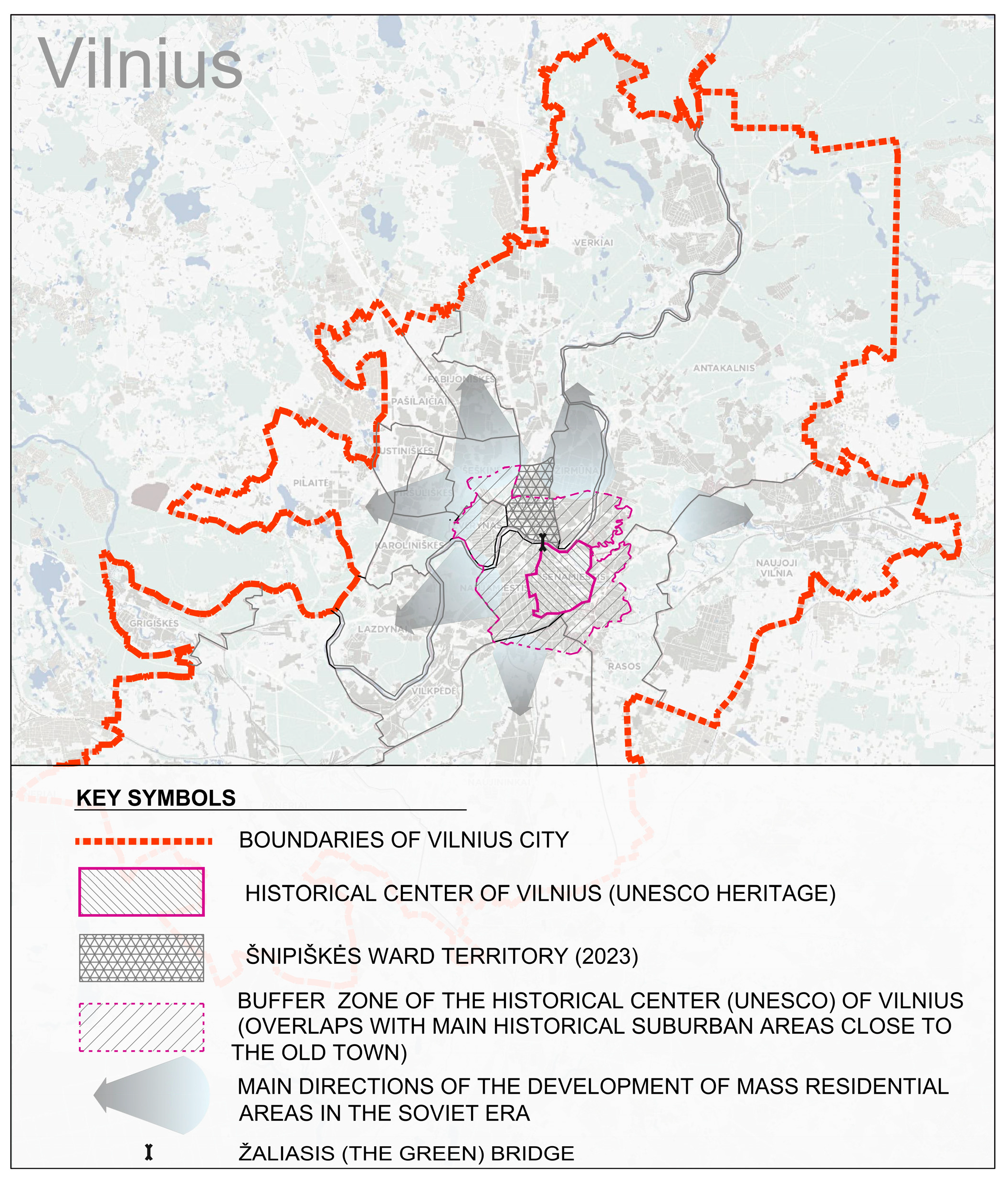
3.1. The Right Bank of the Neris River after the Second World War and Its Post-Soviet Urban Transformations

The most extensive spatial transformations of Šnipiškės can be linked to two recent historical periods in Lithuania. The first was a strong influence of the ideology of socialism on the processes of urban development of Vilnius that took place along the entire perimeter of the city; however, special attention was paid to the north and west directions (Figure 1). The decision was made to develop a new modern center of the capital in Šnipiškės. The coherent and natural development of the area was interrupted and gave way to a planned development of the city ‘from above’, which was determined by the requirements of Soviet ideology. Meanwhile, the next period of the development of this territory can be linked to the neoliberal ideas of the capitalist period and the experiments in the processes of urban development that began after Lithuania regained its independence in 1990. During the post-Soviet period, the situation in the Šnipiškės area changed significantly: it began to attract local and foreign capital and interest of business and various institutions, and the city’s politicians eventually transformed all this into the relocation of the former city center (Gedimino Avenue and its adjacent areas) to the other side of the Neris River. This process has taken longer than the politicians who initiated it predicted, and today, after sustained efforts, it is not yet completed.
Before the Second World War and the Soviet occupation, the main public spaces in Šnipiškės were the space at the entrance to the Žaliasis (Green) Bridge (the only bridge in Vilnius over the Neris River until the beginning of the twentieth century) and the two historic streets, Šnipiškių and Kalvarijų, along which the suburb evolved. The space at the Žaliasis Bridge and at the entrance to the complex of the Church of St Raphael the Archangel and the monastery, where these two streets start, can be considered the unofficial gateway to Vilnius on the right bank of the Neris. This area can be viewed as a kind of a historic sub-center of the city on the right bank of the Neris; it was a passageway to the city, while at the chapel built at the beginning of the eighteenth century (and demolished at the beginning of the Soviet era), people used to gather and pray, including the pilgrims who would walk along the long historical pilgrimage route of Vilnius from Kalvarijų Street to Verkiai [11].
It was in this part of the city that the impressive Neo-Gothic palace of Hilarus Raduszkiewicz was built at the end of the nineteenth century and partly demolished in the 1960s. As evidenced by artists’ surviving drawings and photographs of the site from the end of the nineteenth to the first half of the twentieth century, this once special space was important for the identity of Vilnius before the Soviet occupation [12,13]. During the Soviet years, it was heavily desecrated; some of its religious and cultural–historical symbols, such as the chapel and half of Raduszkiewicz’s palace, were eliminated. ‘Transformed’ to presumably improve traffic conditions, this space has remained almost unchanged since the Soviet period.
The re-establishment of independence marked the beginning of the new development of this part of the city, but there was a lack of serious urban debate about the architectural and urban integrity of the right bank of the Neris within the urban fabric of the city. The area was developed without considering its connections with the Old Town on the opposite (left) bank of the river and the impact on the overall cityscape and urban culture of the capital. Meanwhile, tired of the repertoire of materials that had dominated the Soviet period, architects and developers were fascinated by the possibilities of glass and reinforced concrete. Following the images of American downtowns, the height of the buildings in this area was also substantially increased. The post-Soviet glass architecture of the new Vilnius city center ominously approached the historic core of the city, “squeezing” and “shrinking” the surviving historic buildings and parts of them close to the Žaliasis Bridge. Not only have these processes triggered public debate, but they have also attracted expert criticism [14], comments [15], and recommendations related to height restrictions [16], especially when it comes to the buffer zone of the Old Town of Vilnius, which was granted the status of a UNESCO World Heritage Site in 1994 (Figure 1).
The implementation of Soviet urban developments in this part of the city has already been discussed [17,18]. Based on the studies conducted, it can be argued that the following factors were of great importance for the further development of Šnipiškės:
-
Soviet-era restructuring of the city’s street network;
-
projects for the fundamental redevelopment of the whole or parts of the territory, which were prepared during the occupation period (although a large part of them were not implemented, they significantly contributed to the general consolidation of the narrative of Šnipiškės as an unworthy, problematic and, as a consequence, alterable territory);
-
mono-functional planning and functional disaggregation of the territory;
-
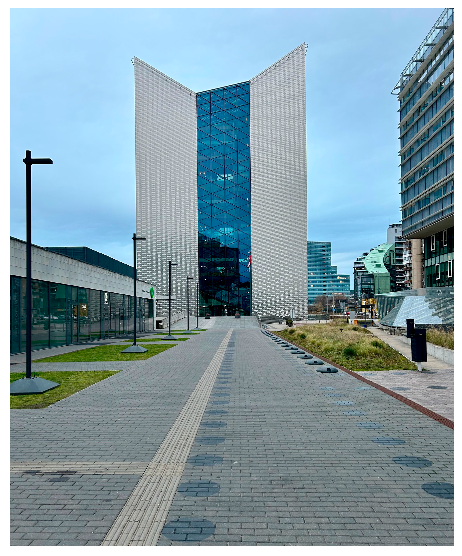
the idea of the ‘Urban Hill’ and the implementation of a new city center that gave the beginning to the current Central Business District (hereinafter CBD).
The fifty years of Soviet occupation in Lithuania were characterized by the building of a new, ideologically constructed social reality and a physical urban environment that was adapted to it and disconnected from traditions. It is the construction, not the creation, which makes it possible to classify all the processes of urban planning and construction of that period as an oversimplified “artificial city” deliberately shaped by the planners, as opposed to the highly structurally complex “natural city”, which over a long period of time evolved from a large number of elements, interconnected and related in various ways, as per the terminology of Christopher Alexander [19].
Although in the general sense the state always operates by stratification of the territory and is “a global (not local) integration” ([20], p. 433), urban planning processes during the Soviet period were extremely mechanical in the pursuit of the interests of dominant political power and the state, dissociated from the historical, social, and cultural contexts. The result of this process is a huge physical and social fragmentation of the city and its individual parts, with the most extreme and stark contrasts in Šnipiškės. As a result of such fragmentation, this part of the city has not yet acquired the properties of a city center, in spite of political and economic decisions. A district with common identifiable properties has not developed in this territory, and only individual smaller characteristic parts of the territory stand out, although districts and streets are key elements of a city image for its structuring and orientation in it [21].
In order to understand one outcome of urban development or another, it makes sense to look at the process itself, its mechanism, and causality. According to the philosophical theory of Gilles Deleuze and Pierre-Félix Guattari, the city should be seen as a historically and culturally temporally layered assemblage that participates in an endless cycle of stabilization, demolition, and creation in the form of territorialization, deterritorialization, and reterritorialization. Here, territorialization is perceived more as a creative process that “mediates the degree to which an assemblage is stabilized or destabilized”, deterritorialization as “the process by which territories are eroded or erased”, and reterritorialization “is the formation of new assemblages” [22]). If we characterize both internal and external forces that influence the disintegration (degradation) of assemblages and the creation of new ones as specific territorial functions or the replacement of territorial functions [23], it was the decision taken in the Soviet period and based on special studies (based on the assessment of the expected directions of urban development) to form a new center of Vilnius in the historic suburb of Šnipiškės [24] that can be attributed to the categories of deterritorialization and reterritorialization as destroying the existing reality and creating a new one based on different principles. The central location of the area and the rather simple wooden architecture that dominated it for a long time created “favourable” circumstances for the redevelopment of the site, as if in a “green field”. The devaluation of the existing architecture and urban structure can be linked to modernism as such, which was presented by its ideologues as a “cure” for the ailing historic city, treating it as a breeding ground for a variety of illnesses, especially tuberculosis, and as completely uninhabitable [25].
The Soviet era in Lithuania and its capital Vilnius is primarily characterized by the development of the city by means of “sleeping” (residential) districts of typical blocks of flats and the new and renewed network of streets strongly associated with it. In more than 40 years, the city of Vilnius has expanded approximately two and a half times in size [26]. One can say that the territory of Šnipiškės was influenced by two vectors: the external one, related to increasing the connectivity of the expanding city and improving its permeability through the construction of new streets, and the internal one, related to the creation of a new center with its own internal structure. Vilnius was criss-crossed with new streets and highways, in line with the ideology of the time that glorified progress and the scientific-technical revolution that underpinned it. The city had to be permeable and functional, like a well-tuned machine. Incidentally, this attitude was very close to the modernist urban design matrix advocated by Le Corbusier. As a symptom of the inability to build cities, the planners and urban designers’ belief that solving transport problems would also solve the “great urban challenge”, which was particularly characteristic of the twentieth century, was reflected in a destructive focus on the car ([27], p. 31). Although some of the aggressive projects of the Soviet period were never realized in Šnipiškės, the ‘improved’ and ‘knocked out’ small-scale street network typical of a city has had negative consequences: the fragmentation of the territory and the disruption of connections both within and with the surrounding areas. The most notable changes should be associated with the emergence of Geležinio Vilko Street that separated Šnipiškės from the present-day Šeškinė Geomorphological Reserve; the construction of traffic-intensive Konstitucijos Avenue, which divided Šnipiškės into separate parts in the east–west direction; the widening of Žalgirio Street; and the transformation of the historic Kalvarijų Street into a busy traffic artery, giving priority to cars (Figure 2).
Along with the formation or renovation of these new streets, the significance of some old historic routes has diminished or partially lost their functionality. Recognition of historical and cultural significance of naturally occurring routes and destinations was rejected. A small part of the route of Šnipiškių Street (formerly Ukmergės) was converted into a pedestrian street—a new type of a public space that started to be developed in the 1970s in many Lithuanian cities [28]—between the buildings of the newly formed city’s public center, with the rest of the street basically destroyed. In the Soviet period, this street ended at the Lietuva Hotel; Lithuania’s first 22-story high-rise opened in 1983. Currently, it ends slightly farther along, at the Swedbank building (2009) (Figure 3). Although the street was extended as an inner space of the bank building, such a spatial and architectural solution is not at all obvious to the spectator on the outside. Nonetheless, here, the building of the bank becomes a landmark, a modern cultural cathedral [29], except that it is dissociated from the transcendence characteristic of churches that used to dominate the skyline of old cities. Accordingly, Krokuvos Street, which used to connect the eastern and western parts of Šnipiškės by crossing Kalvarijų Street, has also lost its historical significance. Currently, it is just an internal street in the district, without pavement and other modern infrastructure, with some of the old cobblestone paving preserved. Parallel to Krokuvos Street, Lvivo Street has also lost its historical significance and has become a street serving the business center. Both streets lost their significance with the construction, in Soviet times, of the four-lane Konstitucijos Avenue (widened to seven lanes during the independence period) providing almost double the number of lanes.
Konstitucijos Avenue remains the traffic-intensive street creating the largest physical and psychological barrier between the different parts of Šnipiškės, a kind of urban highway, the emergence of which was criticized many years ago by urban historian and theorist Lewis Mumford [30]. The street is currently used for large-scale events, such as military parades and car shows (Figure 4). With the expansion of the “Urban Hill” and the CBD on the other side of Konstitucijos Avenue after 1990, the “Global Landscape” territory became established on both sides of the traffic-intensive street that “destroys” the most culturally specific—the wooden part—of Šnipiškės. This area in Rapoport’s terminology, though unchanged for quite a long time as a hard-to-transform “culture core”, in recent years seems to have more features of an eagerly changing “culture periphery” [31]. The area of wooden houses is often viewed negatively in the public space and even by local residents and conflicts with the desirable image painted by modernity. Therefore, in order to achieve the desired contemporary image, the quality and comfort standard of our times, global elements, which slowly destroy the authenticity of the historic environment, are being used everywhere [31].
The urban transformations of the Soviet period were directed toward urban development by turning away from traditional models of the creation of cities. The Garden Square formed near the intersection of Konstitucijos and Kalvarijų streets during the occupation period, now named after Jonas Jablonskis, or the public space in front of the current National Art Gallery building (former Museum of Revolution, 1980, architects Gediminas Baravykas and Vytautas Vielius; Reconstruction 2009, architects Andrius Bučas, Gintaras Kuginys, and Darius Čaplinskas) are more transit spaces rather than meeting places for people and social exchange. If Jonas Jablonskis Garden Square is a typical example of the period, abandoning the principles of public space design characteristic of historic cities as identified by Camillo Sitte, such as distancing and separation of green areas from traffic arteries, their enclosed character protecting from wind and dust [32], its greatest advantage is that now the mature trees seamlessly complement the landscaping initiatives of the city’s public spaces, especially the streets and their approaches. In order to make the city more comfortable and attractive to its residents, a process of street de-Sovietization was launched in 2021, and, following the example of New York and adapting it to the context of Vilnius, the Vilnius Street Standard was developed in order to transform new and reconstructed streets from uncomfortable and unsafe into Western-type streets (with greenery, small architecture, more varied surfacing, and livelier facades along the streets). The new Kernavės Street, which crosses the central part of Šnipiškės (the Giedraičiai sub-ward) in the north–south direction, was constructed in accordance with these standards, with two lanes separated by a green strip and richly planted; it is convenient for both pedestrians and cyclists and is considerably more welcoming for the residents who are crossing the street from one side to the other. Although it is an excellent example of a slow-moving street in a modern city in terms of physical convenience and versatility, the overall proportions and character of the street itself and the development that shape it are quite alien to this historic part of the city.
In the post-Soviet period, in the first decade (“the early transitional phase of post-communist urbanism”), the principles of urban planning were still changing very slowly, and it was only between 2000 and 2010 (“the mature transitional phase”) that the processes of urban development became very intense ([4], pp. 134, 136). The first square in Šnipiškės of the latter period, formed in 2004 and named ‘Europa’ on the occasion of Lithuania’s accession to the EU, is surrounded by the buildings of a new business and administration complex (architects Audrius Ambrasas, Donatas Malinauskas, and Jovita Petkuvienė); however, it is virtually ‘closed’ to the historic Giedraičių and Lvivo streets and is facing the busy Konstitucijos Avenue (which is crossed by a pedestrian underpass at this spot). This is one of the reasons why the square is lacking people and social life. Although the square is quite cozy and somewhat enclosed, it lacks connectivity, which is the path to urban coherence at all scales [33]. The square belongs not to the historical and cultural identities and spatial system of the part of the district in which it is located, but to the contemporary CBD, thus obeying the dictate of novelty and the cyclical nature of office working hours.
Another new public space that deserves special mention is fitted on the roof of the lower part of the aforementioned Swedbank building (2009) (Figure 5, “B”). Like a tribute to the city, the impressive terrace surfaced with broken surface wood, along with the public space developed next to the National Art Gallery still in Soviet times and a pedestrian path along the facade of the bank, form a certain system of spaces (Figure 5). In its nature, the terrace is intended for rest and is interspersed with plants. The path along the bank building (Figure 5, “C”) is mostly used as a route from Šnipiškės to the Old Town, the Žaliasis Bridge, or the Baltasis (White) pedestrian bridge built in 1996. On rare occasions, the square in front of the National Art Gallery is used for events (Figure 5, “A”). All of these spaces, especially the Soviet-era ones, lack the enclosure in an open space next to a river valley that would provide shelter from the winds, but most of all, they lack variety, which is why all of them are, very often, practically completely empty. The glass facades that frame all these spaces are not welcoming to passers-by because there are no cafes, small shops, or other small establishments (Figure 6), although a vibrant city needs the most intricate and minutest variety of purposes so that they support one another mutually on a regular basis, both economically and socially [27].
Once a year, this ‘inert’ spatial system is transformed by the blossoming sakuras of Chiyune Sugihara Park that attracts crowds of people and all kinds of action. The idea of the garden and the sakura trees symbolically connected this space with the Giedraičiai sub-ward on the other side of Konstitucijos Avenue, where the city’s Japanese Garden was opened in 2023. Garden planting has a transformative, life-giving, and connective effect on the territory. In general, this direction of creating gardens in Šnipiškės contributes to the formation of a magical and symbolic identity of the place, especially since the gardens, although full of traditional fruit trees, are historically characteristic and a small part of them has survived.
Nonetheless, viewing the garden as a separate element rather than as part of a system of public spaces questions some solutions that seem to have come from the twentieth century. Although the main conceptual function of the Japanese Garden is to be a haven of tranquility and an escape from the noisy and intense urban environment [34], the park is rather noisy due to Geležinio Vilko and other streets located next to where it is situated. Also, at the expense of the Japanese Garden area, a new car park was built next to the highway as a tribute to transport and the offices built nearby, thus further distancing people from the Šeškinė Geomorphological Reserve as a potentially larger and more natural recreational area.
Despite previous and more recent controversies in urban development, the period of independence increasingly is seeing a growing attempt to return to the issues of the human dimension, the formation of new public spaces, and their vitality. In recent years, the planning of new public spaces and systems of these spaces within the territory, in particular within the boundaries of the Giedraičių sub-ward: Šnipiškių square (2024), Drakono pieva (Dragon’s Meadow, 2022), and Japanese Garden (2023) — attempt to revitalize the territory by forming new urban center in area that is constrained by traffic-intensive streets and have been abandoned for a long time. At this point one can recall the failed project of the Žalgiris residential area (that also included the current Giedraičiai sub-ward), which, even in Soviet times, was strongly criticized for its monotony, typical character, and incompatibility with the historic context [35]. During the time of its planning and anticipation, the suburban territory was badly neglected and became marginalized both physically and socially.
Here, it can be concluded that the urban transformation of Šnipiškės, especially of the Soviet period but also during the years of independence, lacked and is still lacking not only the appreciation of the human scale, but also of the essential “smooth” quality characteristic of historic cities, when the implemented changes are preserving and reflecting, in a diverse manner, the addition to the existing structure and the pursuit of wholeness, which results in a natural and mostly effortless formation of a beautiful and intricate living environment [36]. An important aspect of such environments is that they are characterized by urbanistic coherence, which has a positive effect on human psychology by creating a living architecture expressed by emotional nourishment, which manifests itself through a sense of security stemming from the sense of connectedness typical of mammals [37].
The reference to local history and culture in the restoration of the historic—cobblestone—paving of some of the old streets and in the marking of the old routes through the pavements can also be seen as related to the creation of an environment that nurtures the psychological comfort and emotional well-being of the individual, although these are only the missing parts of a whole. These would include Fino and Daugėliškio streets. To a certain extent, this contributes to the creation of proportions, texture, spatial quality, and a more intimate, slower-speed inner neighborhood environment characteristic of Šnipiškės, yet the character of this old part of the city remains undefined; it has lost its old features and has not gained new ones.

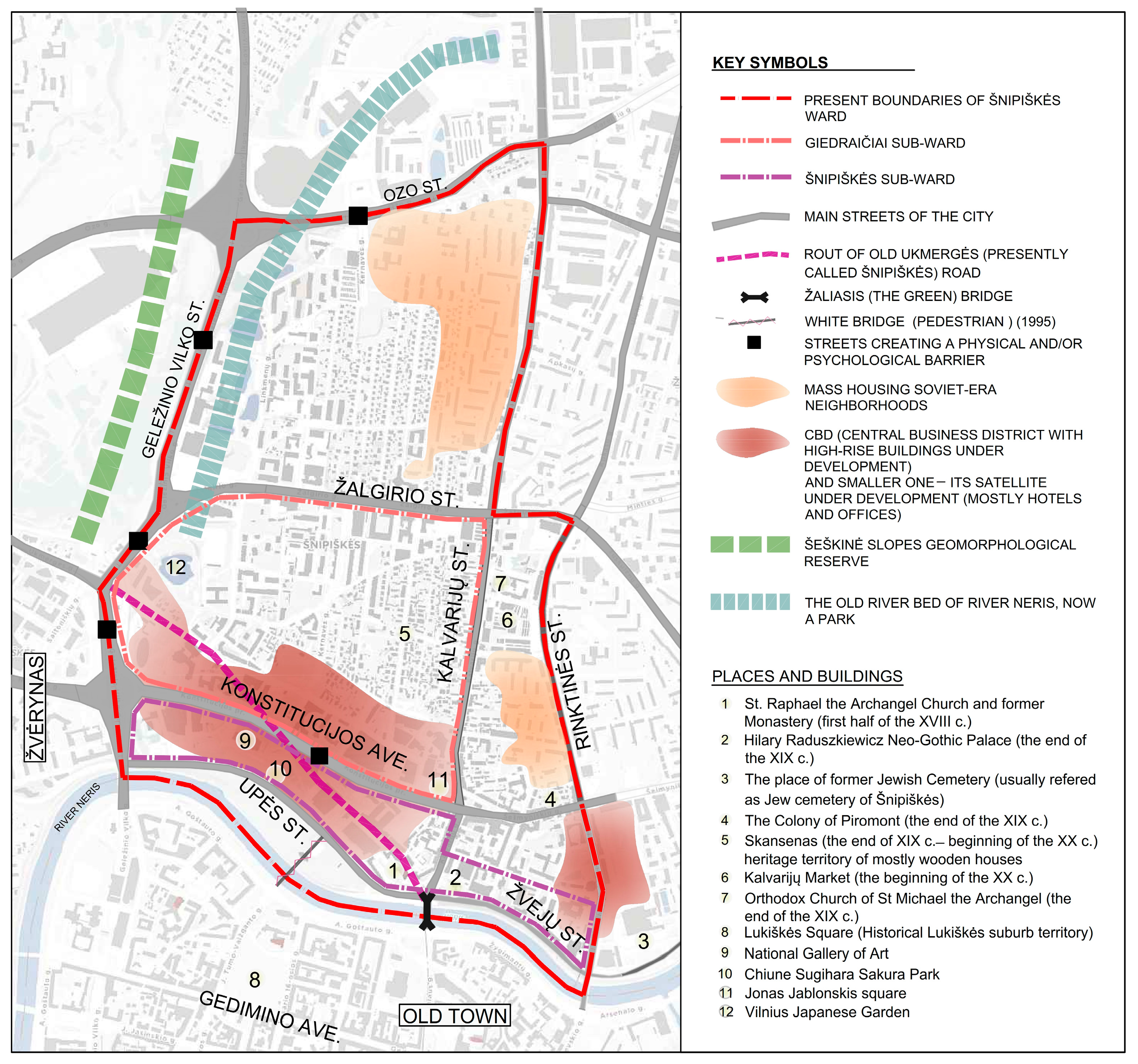
3.2. The Architectural and Cultural Specificity of the Šnipiškės Area

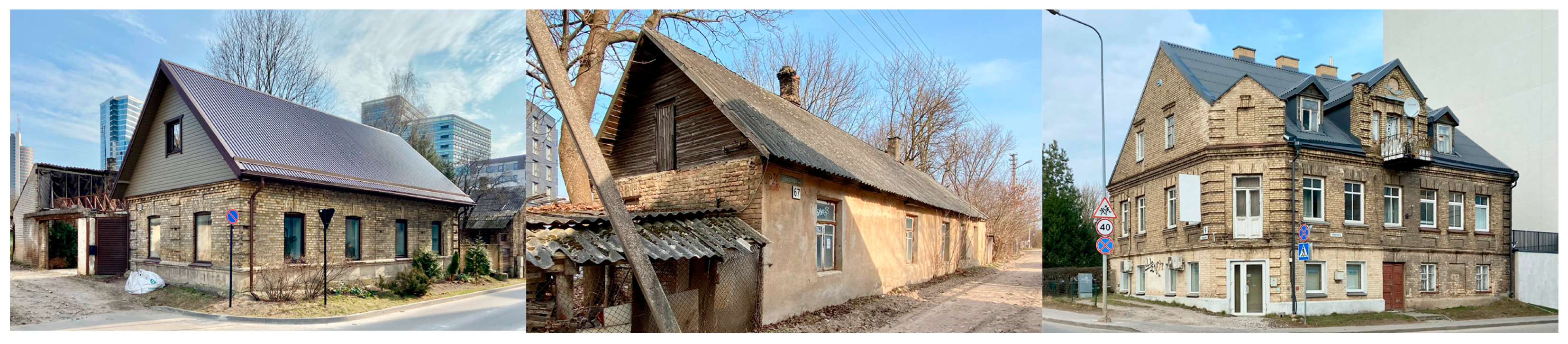
3.2.1. Architectural Peculiarities of the Local Heritage

The historic development of Šnipiškės is distinguished not only by its urban layout and scale, but also by the height and materials of the buildings, the archetypical form of the houses, and the small details that are closely linked to the genius loci of the place and the local identity. As a whole, the features are linked to our personal or collective memory and values, and the identity of a place distinguishes one geographical and urban area from another and makes it unique [38]. Such a culturally and historically charged, vibrant, and multi-layered environment is one in which people can sense their existence as human beings and feel comfortable [39]. It is psychologically more favorable for people, as a bond develops between the individual and the built environment they have created that is directly related to their well-being, quality of life, satisfaction, and a sense of relaxation [40].
The characteristics of Šnipiškės’ old historic buildings have been described by the present authors in previous publications [41]. In the previous study, it was stated that the unique architectural face of Šnipiškės and especially the Giedraičiai sub-ward (Figure 7 and Figure 8) is determined by the wooden buildings of this historic suburb.
Larger and smaller wooden houses, wooden superstructures and extensions of brick buildings, wooden outbuildings, and even fences give this neighborhood a distinctive and specific character, while serving as a visual reminder of the peculiarities of the architectural development of the whole of Vilnius (Figure 8). The change in Šnipiškės’ historical heritage reflects its natural evolution from a historic suburb into an urban district, with its architecture gradually became more elaborate and urban. This natural process is characterized by a steady, relatively slow, and non-aggressive urban and architectural change, essentially adapting to the local and urban scales, materiality, and traditions (Table 1).
The largest concentration of wooden buildings is preserved as a kind of island in and around the protected area known as Skansen. It is here that the largest assemblage of variously interconnected, intertwined, and interlinked wooden (and occasionally brick) buildings remains. It should be noted that even in the case of urban wooden architecture, there is a peculiar similarity of the totality of its buildings that may be determined by the typical design used in Šnipiškės mentioned by the architect Jūratė Jurevičienė [42], which may indicate that the value lies in the whole rather than in the detail.
The wooden buildings preserved until the beginning of this century gave Šnipiškės, which over time became the center of the city, a unique resemblance to a village. Currently, the historic buildings remain only as islands of sorts in the Giedraičiai sub-ward. The existing wooden houses are particularly poor due to neglect and abandonment, and without urgent conservation or restoration work, the wooden buildings and their details continue to deteriorate rapidly. Despite the current severe physical neglect, it perfectly illustrates the connectivity of the “natural city” [19] and reflects the former social structure and its vitality. As a former outskirt and suburb of Vilnius, Šnipiškės aptly illustrates the historical peculiarities of suburban architecture, where the most accessible, easiest to work with, and cheapest to process local material—wood—was used for construction. Like nowhere else in Vilnius, the area of Šnipiškės, bounded by today’s Kalvarijų, Žalgirio, Lvivo, and Linkmenų streets, still has a relatively large number of very simple and laconic wooden buildings.
Although the identity of Šnipiškės is attributed to wooden rather than brick architecture, there are historic masonry buildings that have survived to this day (Figure 9). Their number increased until the Soviet occupation in 1940 (when everything came to a standstill due to nationalization), as the area became more and more integrated into the city. It should be noted that from the sixteenth century, Šnipiškės was famous for the production of building materials in general; there used to be sawmills in the area, and due to the good-quality clay found nearby, large amounts of bricks, tiles, and furnace tiles were produced [43].
The church and the monastery of St. Raphael, with the adjacent plastered two-story buildings with attics and red-tiled roofs form a distinct ensemble in the Šnipiškės sub-ward. Up to the intersection with Konstitucijos Avenue, Kalvarijų Street is lined with similar buildings, which here are taller, of three floors. The building closest to this intersection is somewhat more exceptional; it is not plastered, with yellowish-brown brick facades. If the mentioned plastered buildings at St Raphael’s Church can be architecturally seen as a continuation of the Old Town of Vilnius on the left bank, the latter building on the corner stands out for its simpler and poorer decoration. More examples of such unplastered brownish brick facades can be found further into Šnipiškės from St Raphael’s Church.
As in the case of old wooden architecture, there are also brick buildings that are not characterized by their architectural expression and are often in a rather poor physical condition, but are nevertheless part of Šnipiškės’ old building fabric. Some buildings combine brick and wooden elements and reflect a transitional architectural type. However, there is no doubt that the proportion of brick buildings is lower in the area of the Giedraičiai sub-ward, which was dominated by wooden buildings.
To summarize, the historic urban fabric and the diverse architectural peculiarities of the local timber and masonry heritage create a unique urban landscape that embodies Šnipiškės’ genius loci. The noticeable progression from simple rural-style wooden houses to urban designs with larger volumes and more complex features reflects the natural processes and connectivity inherent in natural development. This architectural diversity in Šnipiškės creates a unique urban fabric that reflects the cultural significance within Vilnius and contributes to the cultural identity of the city as a whole.

3.2.2. The Right Bank of the Neris River and the Developments in Its Approaches

When we speak of the new buildings in the sub-wards of Šnipiškės and Giedraičiai (Figure 2), we refer to the buildings that were built here after the Second World War. In the light of the ideas for the creation of the new city imposed by Soviet social engineering, these buildings with their architecture had—or still have—to represent Vilnius as a progressive, advanced, and modern city. Since there are quite a lot of them, we will focus on the ones that are the most characteristic and exceptional architecturally and discuss their features and their relationship with local historic architecture. Probably one of the most conspicuous buildings is the former Museum of Revolution, the present National Art Gallery. It is said to be an important compositional element of the right bank of the Neris River, the main idea of the form of which was emphatically massive and blind with rhythmically arranged cubes leaning on visually light glass partitions [44]. Such architecture resonates with the architecture of smooth white planes promoted by Le Corbusier, which, as was believed at the time, was not only hygienic (as opposed to the architecture of historic cities) but also supposed to act as a kind of an anesthetic for the sensitized nervous system of the post-war population [25]. Today, it is a massive structure, visually distant from streets and other buildings, which has nothing to do with the context of the old Šnipiškės. It is a typical example of a project designed as though for an empty field, whose link to its surroundings is purely through the connections of the paths, the square, and accesses to the surrounding infrastructure and through the reaction to the terrain. However, neither fabric- nor volume-wise, nor in this building’s details is there anything that would connect it with the historic local architecture; we do not detect any visual or semantic links.
Another, one could say, iconic building on the right bank of the Neris and in the Šnipiškės sub-ward is the aforementioned Hotel Lietuva (now Radisson). Allegedly, it was the most prominent element in the project of the new city center [44]. The building consists of a horizontal volume descending in terraces on a hillside and a vertical tower. The latter marked the beginning of the well-known idea of the urban hill in Vilnius and still is a prominent feature of the right bank of the Neris in various cityscapes and perspectives. The hotel building is another example of architecture that did not seek a closer contact with the old local context.
Among the buildings of a similar architectural character in terms of their response to the context, we can mention Vilnius Central Department Store built in 1973 (architects Zigmantas Liandzbergis, Vytautas Vielius, and Česlovas Gerliakas) and reconstructed in 2003 by the architect Leonidas Merkinas, which, with its rectangular box-like volume, is still a strong and dominant landmark on the right bank of the Neris today. Other notable buildings built in the territory of Šnipiškės during the Soviet era, such as the Lithuanian Children and Youth Center at 25 Konstitucijos Avenue (architect Česlovas Mazūras), do not have any clearer connection with the old context of the site. It seems that these buildings were built as if in vacuum, focusing more on the compositional and functional issues of the object and possibly responding to more planning-relevant infrastructural or compositional urban axes, which are not visible to the ordinary viewer in the vicinity of the building.
In terms of the scale of the development, materials, and the volumetric form, the visual dissonance between the old and the new architecture in the sub-wards of Šnipiškės and Giedraičiai persisted even after the restoration of independence. At this point it should be noted that most of the Soviet-period buildings were constructed in the administrative subdivision of the sub-ward of Šnipiškės between the Neris and Konstitucijos Avenue, where the part of the old surviving architecture is proportionally small, brick, and plastered and is basically concentrated closer to Kalvarijų Street, and therefore the architectural contrasts between the new and old buildings are at greater distances and less active. Meanwhile, during the period of independence, a number of compositionally interesting yet independent and visually self-oriented architectural structures appeared in this area. Of these, mention should be made of the Forum Palace, a terraced building with a dominant elliptical volume (architects Gintaras Čaikauskas, Rolandas Palekas, and Miroslav Šeininckij, 2003), the laconic SEB Bank building of glass and black metal (architectural studio AKG, 2017), or perhaps the most architecturally autonomous of them, the towers of the Artery Business Center (architect Daniel Libeskind), which is shaped like blocks of ice stuck in the ground. It was during the period of independence that the new architecture ‘moved’ more actively across Konstitucijos Avenue and already approached the old smaller-scale brick and wooden buildings of the Giedraičiai sub-ward. Despite this ‘move’, we find almost no signs of a response to the characteristics of the old local architectural context in the architecture of many of these structures. Here, we should speak of the high-rise structures surrounding Europa Square built in 2004: the Vilnius City Municipality (architect Arūnas Eduardas Paslaitis and co-authors), the Europa Tower (architect Audrius Ambrasas and co-authors), and the multi-story residential building at 9 Konstitucijos Avenue (architectural studio AKG), along with the lower buildings of the complex that include offices, a shopping mall, and a garage. Politicians and businessmen seem to be inexorably attracted to the construction of tall buildings, as, according to Deyan Sudjic, this may have something to do with straightforward symbolism: to be the biggest or the tallest is to be important [45].
The structure and style of these buildings are dominated by glass, metal, concrete, composite facade panels, and large, monumental volumes (Figure 10). Probably the most autonomous in its form, volume, and materiality is the so-called ‘Harp’ apartment building at 15 Konstitucijos Avenue (architects Valdas and Jonas Treinys, 2005/2016), which, due to its size and one-plot development, still glaringly contrasts with the islands of the old development of Šnipiškės, both in the near and distant perspectives. The new buildings, which are completely contrasting in their architecture, moved even further toward the old Šnipiškės in the 2010s after crossing Lvivo Street away from the Neris River. These include the essentially all-glass Three Sails Towers (architect Leonidas Merkinas, completed in 2018) and the administrative building at 37 Lvivo Street (architectural studio Cloud Architects, 2017). The latter, which is in very close proximity to the surviving wooden houses on Giedraičių, Krokuvos, and Lvivo streets, creates extraordinary contrasts in material, volume, and scale in different perspectives. Often, most of the new contemporary buildings on the right bank of the Neris lack the quality of intricacy as an additional dimension and are limited to a kind of superficiality that ends at ‘the slab block, the gridiron of the curtain walling, the banality of pastel shaded surfaces’ [46] (p. 65). Some of the mentioned contrasts between the new and the old architecture of the locality are an illustration of the lack of combinability referred to in studies, when the objects have no relation either with one another or with the individual who can leave no imprint or memory of theirs on the modern surfaces of glass and steel buildings.
One of the most prominent and visually impressive buildings on the right bank of the Neris is the Swedbank building (Figure 11). In this object, panels of glued wood are attached to the facades of the multi-story structure, which like vertical blinds cover a glass shopfront. Another key element is the 4500 m2 wooden terrace on the roof of the lowest part of the building. In the bank building, these wooden elements with their color and texture qualities counterbalance the associations of coldness and formality triggered by the surfaces of glass, metal, and concrete planes, and at the same time, there is a link, albeit distant, with the historic wooden architecture of Šnipiškės. It is perhaps the only administrative building in the New Center of Vilnius that responds to the local heritage context with a contemporary expression in its architecture.

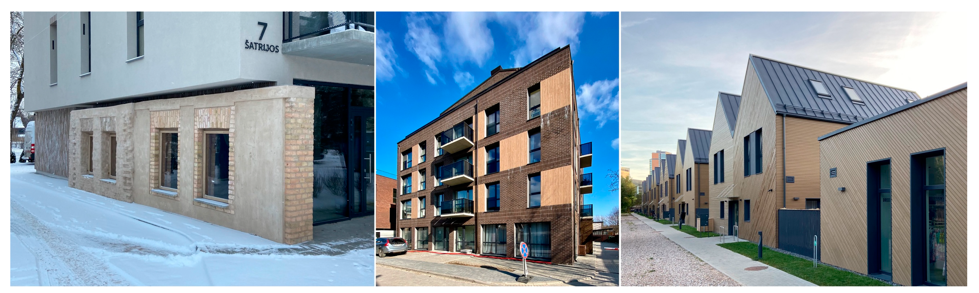
3.2.3. The Outcomes of the (R)evolution of the Residential Zone

The new (Soviet and post-Soviet) architecture in Šnipiškės, including residential architecture from the occupation period onward, is characterized by volumes and heights that differ considerably from both the former historic suburb and the Old Town. The argument for increasing the height is, presumably, the inevitable densification of the city center. This excuse was—and still is—used to justify the destruction of historic construction. But density as such does not create a better environment and, in particular, an environment suitable for permanent human habitation. Research has established a direct correlation between high densities (including intensity) and poor mental and physical health for local residents [47]. It has been observed that areas built up with large buildings lack vitality and do not develop interconnections between their elements and as the height of buildings increases, people’s links to the city gradually diminish [48].
Among the new residential buildings in Šnipiškės that stand out for their volume and height, mention must be made of the multi-story block of flats at 13 Konstitucijos Avenue, built in Soviet times and with features of Brutalist architecture; the multi-story building at 92 Žalgirio Street, constructed during the period of independence; and the multi-story block of flats consisting of two square towers at 11 Daugėliškio Street. Incidentally, the latter is one of the most typical examples of buildings with little connectivity to their surroundings; the nature and form of the one-plot development on the site have no obvious analogues in the area. The few surviving wooden houses in the vicinity speak of the great architectural contrasts between these new residential buildings and the historic ones, which are even more pronounced from a philosophical perspective, asking what is being built, homes or houses? If the comfort zone of a home is associated with a certain vertical axis, the center of a home connecting the underground world with the above-ground world, which most often used to be embodied by the fireplace [49], then what kind of comfort—not physical but emotional—can be offered by the blocks of flats that are being built here today, which, according to Gaston Bachelard, are boxes stacked on top of one another, with neither a surrounding space filled with old green garden trees nor a verticality of their own, but only an external height [50].
Among the more recently completed apartment buildings, the buildings at 17 Kernavės Street, 60 Krokuvos Street, and 39 and 41 Giedraičių Street stand out in terms of both their length and their mass. Generally speaking, these are structures which, when viewed through the prism of human needs and sensations, have a “devastating effect on human beings and on human society” [39] (p. 24). Yet again, they are united by the otherness of their architectural expression from the existing historic context of Šnipiškės. Overall, the design did not aim for material harmony with the old buildings of the site; there is no evidence of segmentation of the new structures, nor of an attempt to approximate the finer scale of the local buildings in this way. The presence of pitched roofs was forgotten, and the possibility of their interpretation was not even considered (Figure 12).
Strangely, the architecture of the latter buildings follows exactly the same principles of construction on the boundaries of new neighborhoods in the fields on the outskirts of town. The absence of response to the existing historic context is not too surprising given the ubiquity of the phenomenon, but the inability to respond in any way, even in the context of the so-called CBD, without challenging the new, the innovative, and the exceptional is puzzling. Built in 2005, the apartment building at 3 A. Juozapavičiaus Street (architects Kęstutis Pempė, Lijana Jančytė, and Eglė Kirdulienė) can be considered a peculiar yet unsuccessful experiment. The glazing system used for the facades of this building was presumably intended to give the impression of modern progressive architecture; perhaps it was even hoped that the otherness of such a mirror facade and transparency would help to ensure an appropriate relationship with the architectural features of the Neo-Gothic building of Raduszkiewicz Palace nearby. Today, however, it is simply a physically and esthetically aging large-volume and high-rise (12 storys) apartment block in a very close yet not artistically intriguing contrast with the historic development of Šnipiškės of exceptional esthetics.
In the context of relatively more mundane professional issues, the eye is caught by the primitiveness and simplicity of the architecture of the majority of the new residential buildings that disregards the necessity of designing even blocks of flats in a way so as to ensure people’s psychological well-being through the consolidation of the relationship between the residents and the environment that surrounds them. Although for many apartment dwellers the balcony is their only connection to the outdoors (their personal outdoor place), balconies that reach a depth of ~183 cm (the minimum for comfortable use of these spaces) are rare, as there are no balconies partially incorporated into the building, even when this is one of the ways of ensuring a degree of privacy and the sense of security required in a building of this type [51]; also, in our climatic zone, they offer partial wind protection, which can be found in various forms in the historic architecture of Šnipiškės we have discussed.
Nonetheless, Still, the relatively few manifestations of contextuality and links to local tradition do appear in the new architecture of the part of Šnipiškės under study (Figure 13). One of the earliest attempts to consider local architectural features in the architecture of apartment buildings was the so-called “Naujasis Skansenas” (New Skansen) housing quarter (architects Algirdas Kaušpėdas and co-authors, under construction). Unfortunately, it has remained more of a marketing name, because in the architectural expression of the buildings, it is difficult to see any similarity with the real Skansen (in Sweden) or the Skansen in Šnipiškės. The facades of the apartment building at 3 Kintų Street, where, in addition to clinker tiles, panels imitating wood were also used to reflect the material context of the site to a greater extent, marked the attempt to be more reflective of the local context (architectural studio Architectura Humana, 2021). Real wood was used in the facade cladding in the ‘Namai-Kintai’ project (architectural studios Architektūros linija and PAO architektai, 2022). The latter complex of buildings is remarkable for its successful adaptation to the former wooden buildings and the scale of the site. In addition to a four-story apartment building (relatively low compared to the usual height of the new buildings), with wooden paneling used for balcony railings and facade fragments, there is also a row of semi-detached dwellings with wood dominant in the facade decoration. In terms of the nature of their construction and materials, the latter are probably the most contextual buildings recently constructed in this area of Šnipiškės. When looking for contextuality and a connection with the local historical architecture in the new buildings, mention should be made of the building at 7 Šatrijos Street (architectural studio SP architektų grupė). Although the form of the building is elementary—it is box-shaped—one can see the architects’ attempts to reflect in the esthetics of the facades the heterogeneity of the historic development of Šnipiškės or even the rather common division of some of the buildings into the owners’ separate sections and their individual finishes. The preserved/restored brick wall of the old former building in the new house is noteworthy.

4. Discussion

The process of forming the new center of Vilnius during the Soviet era can be described as a mechanical urban process determined and encouraged by the ideology of the time that was strongly linked to the repressive system of the Soviet occupation and the ideology of modernism that had been prevalent in architecture and urbanism since the 1960s. The traditional principles and models of urban design gradually were forsaken. As a result of these changes, the historic urban fabric was ignored, deformed, and fragmented; lifeless spaces were produced; and the territory was fragmented functionally, morphologically, and—ultimately—esthetically.
Although the urban projects of the independence period (i.e., after 1990) show a clear break with the norms and principles of urban design introduced during the occupation, another extreme has recently emerged in the forming of the capital’s new center: the creation of the city has become a tool of the institutions that control capital, the modern economic power, and unified global images and norms of the standardized downtown continue to be introduced as a consequence of these changes, in exactly the same way that the processes of the Soviet period were destroying the uniqueness of the place and the remaining authentic features.
An assessment of these changes therefore leads to the following conclusion: after the above-mentioned political and economic changes in Eastern Europe and Lithuania, Šnipiškės, which has become the new political and economic center of Vilnius, became fragmented physically, morphologically, and in terms of its cultural–historical identity. The historic territory, the urban assemblage of Šnipiškės with a certain mutual synergy of its elements, as conceptualized by Deleuze and Guattari, was fundamentally altered.
We have no doubt that urban development is characterized by (and requires) constant change and dynamism, constant becoming, the cyclical nature of territorialization, deterritorialization, and reterritorialization, but the question is what are the limits of this change and what price must be paid for it? In our view, the ethical and esthetic costs of the recent changes are very high, as the aspirations for a new city center are largely unfulfilled. This territory has not yet acquired the qualities of a full-fledged city center. Therefore, it has to be stated that the Šnipiškės area, fragmented during the Soviet era, has lost its integrity as a whole, and that the post-Soviet transformations have only exacerbated the urban problems of the former suburban area.
The current intensive process of revitalization of the territory, the creation of the New Center, is quite inert and is influenced by various factors from different periods, but very rarely linked to the creation of wholeness, cultural continuity, and connectivity on the smallest scale, transforming Šnipiškės into a territory of contrasts—a collage described by Colin Rowe. On the one hand, our research indicates that the new contemporary buildings on the right bank of the Neris usually lack the quality of intricacy as an additional dimension and are limited to a certain superficiality of volumetric form and facade esthetics due to the autonomy of their architectural expression. And as a result, on a sensory, subconscious level, such architecture lacks causality, a connection with the environment that allows the creation of connectivity, both mutual and with the human being. This lack is further accentuated by the stark contrasts in terms of volumetric form, scale, and materials with the existing architecture of the territory. On the other hand, it must be added that new residential buildings in Šnipiškės mostly also contrast in their scale and forms in relation to the historic development of the area, and only some of the examples speak of a certain search for contextuality, the phenomenon of continuity and the threads whose emergence is necessary both for the creation of the architectural value of each new building and, more generally, for the cultural value of the transformation of Šnipiškės as such.
The example of the unsuccessful relocation of the city center of Vilnius shows that such projects should be carried out with the utmost responsibility, taking into account the historic layers of the area, its genius loci, and the heritage of modern planning/design, which should be transformed in light of both history and current needs. Public authorities need to take more responsibility for developing a vision for the place and for wider regulation to ensure the vibrancy and coherence of the whole historic area; at the same time, architects should commit to taking their share of responsibility for the design of the physical environment and nurturing its characteristics.
In conclusion, it is important to acknowledge some limitations of this study. First, our analysis focused primarily on the physical and morphological aspects of urban transformation and may not fully capture the socio-economic dynamics at play. Second, the lack of comprehensive data on residents’ perspectives and experiences limits our understanding of how these changes are perceived and lived by the local community. Future research could benefit from including the perspectives of different stakeholders and exploring the social impacts of these urban changes in greater depth.
Additionally, while we have critiqued the lack of connectivity in new developments, a further investigation of specific design strategies that could improve urban coherence and quality of place in the context of dramatic change would be valuable. This could include more detailed case studies of successful urban integration projects in other, particularly post-Soviet, contexts. A comparative examination of the findings of this research with previous studies that have addressed similar issues in different cities around the globe, would also be beneficial. This comparative approach could potentially uncover universal patterns or unique characteristics in urban transformation processes and thus contribute to a more nuanced understanding of urban development in socio-economic transition contexts.

5. Conclusions

In this article, we have discussed how the idea and efforts to relocate the Vilnius city center to another area, which was once peripheral, came about. Our research shows that the failure of the urban process, which is still incomplete but has some clear outlines, is related to several factors. The transformation of the former historical suburb into part of the city was natural and perhaps inevitable. It was determined by various circumstances and factors. However, the gradual development of the area was disrupted in the middle of the 20th century and the modernist way of urbanization was applied. Thus, the character of the area was fundamentally transformed by the urban planning policy of the Soviet period. This policy led to the erosion, disintegration, and elimination of the historical and cultural layers of the area for half a century until the end of the Soviet regime in 1990. Soviet urban planning had unspoken but obvious links to the modernist urban planning of the time, which was characterized by the ideas of Le Corbusier and his followers.
The neglect of the historical and cultural contexts contributed significantly to Šnipiškės losing its former morphological structure, geo-cultural character, and distinctiveness during the Soviet period, when this urban policy prevailed. This process of urban transformations was further accelerated by the capitalist development and neoliberal policies of the post-Soviet period, which were driven by the idea of turning this area into a new administrative, political, and symbolic center of the city. The ambitious but poorly thought-out, rushed vision of relocating the city center, which was not based on more detailed studies and forecasts, led to many subsequent problems that could have been at least partially avoided. Although this process of urban transformation is still ongoing, some insights can already be gained about the urban policy decisions that led to the ongoing failure. In its current form, Šnipiškės resembles a strange mixture of an American urban downtown with high-rise buildings and the relics of a faceless Soviet residential area. The research conducted allows us to believe that the failures in relocating the center of Vilnius can be useful and instructive in avoiding certain urban planning measures in post-Soviet spaces and post-colonial societies. We believe that the relocation of the city center should be neither a mechanical nor a rushed process but should be based on a balanced and well-thought-out approach. Urban policy should not only consider political or economic aspects but also embrace historical and cultural layers as well as the experiences and expectations of local residents and their communities. Last but not least, such decisions must be linked to the concepts of place-making, the genius loci specific to the area, and a detailed analysis of previous urban planning decisions before the urban transformation projects are implemented.

Author Contributions

All three authors contributed equally to the research and work on the article. All authors have read and agreed to the published version of the manuscript.

Funding

The research received no external funding.

Data Availability Statement

Data are contained within the article.

Conflicts of Interest

The authors declare no conflicts of interest.

References

  1. Motieka, S. Besiformuojančio Vilniaus moderniojo centro urbanistinis modelis. Urban. Archit. 2009, 33, 195–210. [Google Scholar] [CrossRef]
  2. Samalavičius, A. Lithuanian Architecture and Urbanism: Essays in History and Aesthetics; Cambridge Scholars Publishing: Newcastle upon Tyne, UK, 2019. [Google Scholar]
  3. Samalavičius, A. Nuo Nekropolio iki Akropolio. Vilniaus Miestovaizdžio Metamorfozės; Kultūros Barai: Vilnius, Lithuania, 2017. [Google Scholar]
  4. Grunskis, T. Transformations and Condition of Urban Public Spaces in Lithuania After 1990. In Modernization of Public Spaces in Lithuanian Cities [Internet]; Sciendo: Warsaw, Poland, 2020; pp. 133–148. Available online: https://sciendo.com/chapter/9788395793875/10.1515/9788395793875-003 (accessed on 15 January 2024).
  5. Lefebvre, H. The Production of Space, 25th ed.; Blackwell Publishing: Hoboken, NJ, USA, 2007. [Google Scholar]
  6. Rowe, C.; Koetter, F. Collage City; The MIT Press: Cambridge, MA, USA; London, UK, 1983. [Google Scholar]
  7. Sýkora, L. Post-Socialist Cities. In International Encyclopedia of Human Geography [Internet]; Elsevier: Amsterdam, The Netherlands, 2009; pp. 387–395. [Google Scholar] [CrossRef]
  8. Sýkora, L. Changes in the internal spatial structure of post-communist Prague. GeoJournal 1999, 49, 79–89. [Google Scholar] [CrossRef]
  9. Hirt, S. Whatever happened to the (post)socialist city? Cities 2013, 32, s29–s38. [Google Scholar] [CrossRef]
  10. Bowen, G.A. Sensitizing Concepts [Internet]; Sage Publications: Thousand Oaks, CA, USA, 2019. [Google Scholar] [CrossRef]
  11. Lietuvos Nacionalinio Dailės Muziejaus Informacija. Paroda „Sakralusis Vilnius: Piligrimų Kelias nuo Aušros Vartų iki Kalvarijų“ [Internet]. Bernardinai.lt. 2021. Available online: https://www.bernardinai.lt/paroda-sakralusis-vilnius-piligrimu-kelias-nuo-ausros-vartu-iki-kalvariju/ (accessed on 30 April 2023).
  12. Matulytė, M. (Ed.) Vilniaus Fotografija 1858–1915; Lietuvos Nacionalinis Muziejus: Vilnius, Lithuania, 2001. [Google Scholar]
  13. Keršytė, D. (Ed.) Vilniaus Vaizdų Atvirukai 1897–1915; Lietuvos Nacionalinis Muziejus: Vilnius, Lithuania, 2019. [Google Scholar]
  14. Bondin, R. Ray Bondin Ataskaita Apie Vilniaus Senamiesčio Detalųjį Planą [Internet]. 2004. Available online: https://unesco.lt/uploads/file/failai_VEIKLA/kultura/Pasaulio_paveldas%20Lietuvoje/vilnius_dok/AD_R%20Bondin_2004_12_LT.pdf (accessed on 20 April 2023).
  15. Vyšniūnas, A. Vilniaus miestas—Tarp metaforos ir pragmatikos. Town Plan. Archit. 2006, 30, 159–176. [Google Scholar]
  16. Ozdemir, B.; Drury, P. Report of the Joint World Heritage Centre/ICOMOS Advisory Mission to the World Heritage Property Vilnius Historic Centre, Lithuania (C 541bis) [Internet]. ICOMOS; Report No.: C 541bis. 2017. Available online: https://whc.unesco.org/en/list/541/documents/ (accessed on 12 April 2024).
  17. Gabrėnienė, A. Visions and Utopias of the Development of Šnipiškės Suburb in Vilnius in 1940–1991. Lituanus 2022, 68, 60–78. [Google Scholar]
  18. Gabrėnienė, A. Soviet-era projects that did and did not happen in the historical site of Šnipiškės in Vilnius. In Facing Post-Socialist Urban Heritage [Internet]; BME Department of Urban Planning and Design: Budapest, Hungary, 2023; Available online: http://doconf.architect.bme.hu/doconf2023-proceedings/ (accessed on 12 January 2024).
  19. Alexander, C. A City Is Not a Tree [Internet], 50th ed.; Mehaffy, M.W., Ed.; Sustasis Press: Portland, OR, USA, 2015; Available online: http://www.sustasis.net/ACINAT-LR.pdf (accessed on 20 February 2024).
  20. Deleuze, G.; Guattari, F. A Thousand Plateaus. Capitalism and Schizophrenia, 11th ed.; University of Minnesota Press: Mineapolis, MN, USA; London, UK, 2005. [Google Scholar]
  21. Lynch, K. The Image of the City; The MIT Press: Cambridge, MA, USA, 1960. [Google Scholar]
  22. Dovey, K. Assembing Architecture. In Deleuze and Architecture; Frichot, H., Loo, S., Eds.; Edinburgh University Press: Edinburgh, UK, 2013; pp. 131–148. [Google Scholar]
  23. Livesey, G. Assemblage. In The Deleuze Dictionary; Parr, A., Ed.; Edinburgh University Press: Edinburgh, UK, 2010; pp. 18–19. [Google Scholar]
  24. Mačiulis, A. Architektai Algimantas ir Vytautas Nasvyčiai; Vilniaus Dailės Akademijos Leidykla: Vilnius, Lithuania, 2007. [Google Scholar]
  25. Colomina, B. X-ray Architecture; Lars Müller Publishers: Zürich, Switzerland, 2019. [Google Scholar]
  26. Stravinskienė, V. Vilniaus Miesto Erdvinė Plėtra 1944–1989 M. Liet. Istor. Metraštis 2021, 2, 119–135. [Google Scholar] [CrossRef]
  27. Jacobs, J. Didžiųjų Amerikos Miestų Mirtis ir Gyvenimas; Lapas: Vilnius, Lithuania, 2020. [Google Scholar]
  28. Grunskis, T. Miesto viešųjų erdvių sistemos samprata ir formavimo modeliai. Acta Acad. Artium Vilnensis 2013, 71, 127–138. [Google Scholar]
  29. Varnelis, K. Cathedrals of the Culture Industry. Los Angeles Forum Archit. Urban Des. Forum Annu. 2004, 2004, 35–40. [Google Scholar]
  30. Mumford, L. The Highway and the City; Mentor Books: New York, NY, USA, 1960. [Google Scholar]
  31. Rapoport, A. Some further Thoughts on Culture and Environment. Archnet-IJAR 2008, 2, 16–39. [Google Scholar]
  32. Sitte, C. The Art of Building Cities; Martino Publishing: Mansfield, CT, USA, 2013. [Google Scholar]
  33. Salingaros, N.A. Complexity and Urban Coherence. J. Urban Des. 2000, 5, 291–316. [Google Scholar] [CrossRef]
  34. Stauskis, G. Japanese gardens outside of Japan: From the export of art to the art of export. Urban. Archit. Town Plan. Archit. 2011, 35, 212–221. [Google Scholar] [CrossRef]
  35. Girčys, G. Dėl konkurso Žalgirio mikrorajono projektui ruošti. Statyba Archit. 1973, 6, 14. [Google Scholar]
  36. Alexander, C. The Nature of Order. Vol. 2: The Process of Creating Life; The Center for Environmental Structure: Berkeley, CA, USA, 2002. [Google Scholar]
  37. Salingaros, N.A. Connecting to the World: Christopher Alexander’s Tool for Human-Centered Desig. She Ji J. Des. Econ. Innov. 2020, 6, 455–479. [Google Scholar] [CrossRef]
  38. Gabrėnienė, A. Šnipiškių tapatybės beieškant. Krantai 2023, 1, 26–29. [Google Scholar]
  39. Alexander, C. Making the Garden. First Things 2016, 260, 23–28. [Google Scholar]
  40. Scannell, L.; Gifford, R. The experienced psychological benefits of place attachment. J. Environ. Psychol. 2017, 51, 256–269. [Google Scholar] [CrossRef]
  41. Samalavičius, A.L.; Gabrėnas, A. The legacy of Lithuanian urban and semi-urban vernacular architecture and possibilities of its preservation. Buildings 2022, 12, 2087. [Google Scholar] [CrossRef]
  42. Traškinaitė, D. Jūratė Jurevičienė. Vilniaus medinė architektūra. Archiforma 2017, 1–2, 132–141. [Google Scholar]
  43. Samalavičius, S. Vilniaus Miesto Kultūra ir Kasdienybė XVII–XVIII Amžiuose; Edukologija: Vilnius, Lithuania, 2011; 512p. [Google Scholar]
  44. Drėmaitė, M.; Lukšionytė-Tolvaišienė, N.; Petrulis, V.; Rimkevičienė, J.; Tutlytė, J. Vilnius 1900–2005 Naujosios Architektūros Gidas; Architektūros Fondas: Vilnius, Lithuania, 2005. [Google Scholar]
  45. Sudjic, D. Galios Architektūra; Lapas: Vilnius, Lithuania, 2023. [Google Scholar]
  46. Cullen, G. The Concise Townscape; Elsevier (Architectural Press): Oxford, UK, 2006. [Google Scholar]
  47. Berghauser Pont, M.; Haupt, P. Spacematrix; Nai010 Publishers: Rotterdam, The Netherlands, 2021. [Google Scholar]
  48. Gehl, J. Miestai ir Žmonės; Lapas: Vilnius, Lithuania, 2023. [Google Scholar]
  49. Robert, J. Autonomija ir heteronomija architektūros teorijoje. In Architektūros Teorija Kitapus (Post)Modernizmo; Samalavičius, A., Ed.; Kultūros Barai: Vilnius, Lithuania, 2021; pp. 75–100. [Google Scholar]
  50. Bachelard, G. Svajonių Džiaugsmas; Vaga: Vilnius, Lithuania, 1993. [Google Scholar]
  51. Alexander, C.; Ishikawa, S.; Silverstein, M.; Jacobson, M.; Fiksdahl-King, I.; Shlomo, A. A Pattern Language; Oxford University Press: New York, NY, USA, 1977. [Google Scholar]
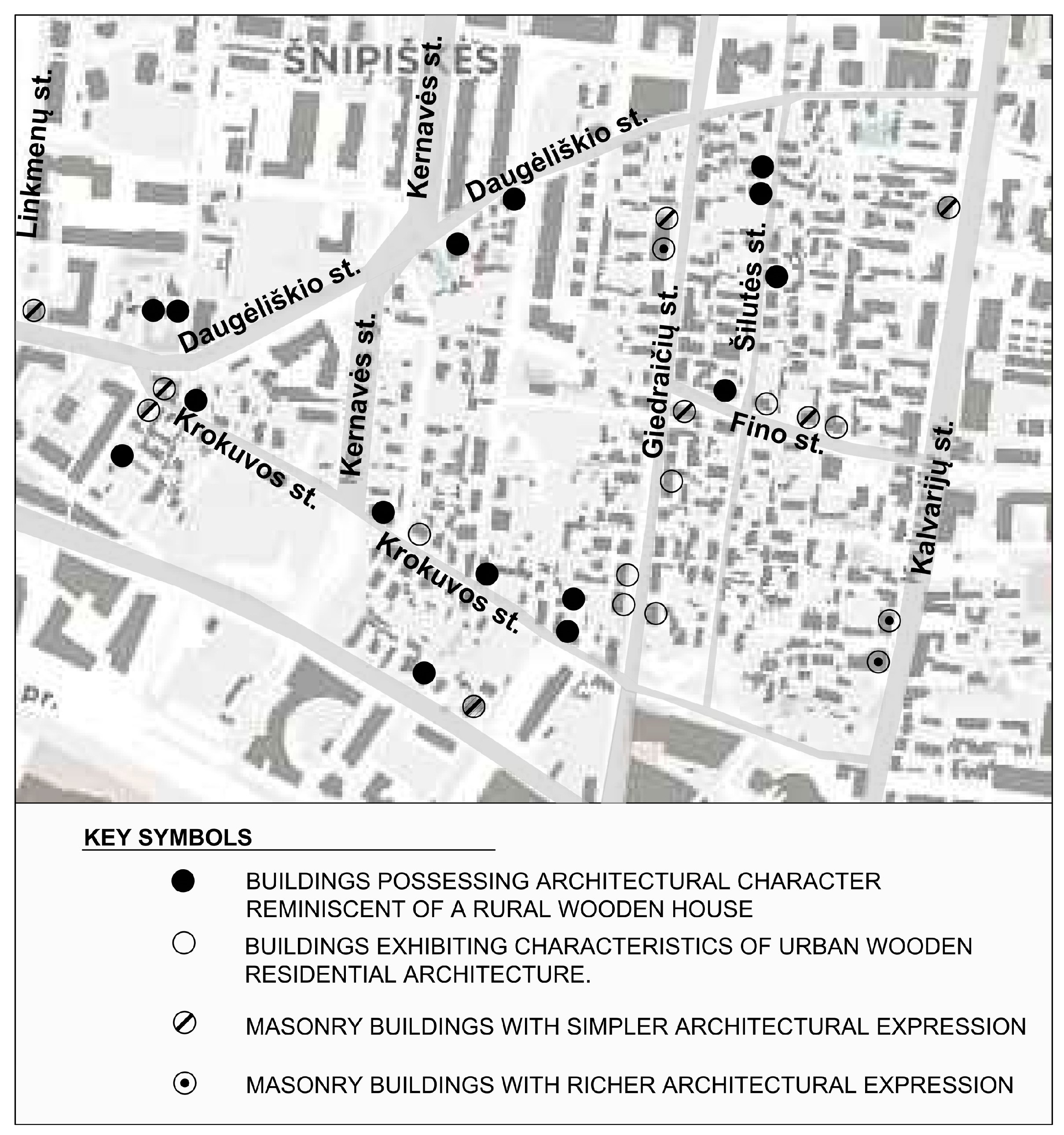
Figure 1. Historical center of Vilnius (UNESCO) and its buffer zone.
Urbansci 08 00112 g001
Figure 2. Scheme of the Šnipiškės ward and its nearest surroundings.
Urbansci 08 00112 g002
Figure 3. Šnipiškių Street (old Ukmergės Road) and the Swedbank building.
Urbansci 08 00112 g003
Figure 4. A military parade on Konstitucijos Avenue.
Urbansci 08 00112 g004
Figure 5. Scheme of public spaces in the CBD (“A”—the square beside the National Art Gallery, “B”—the wooden Swedbank terrace, and “C”—the pedestrian route from Šnipiškės to the Old Town).
Urbansci 08 00112 g005
Figure 6. Public spaces in Šnipiškės. Left to right: (A)—the square beside the National Art Gallery, (B)—the wooden Swedbank terrace, and (C)—the pedestrian route from Šnipiškės to the Old Town.
Urbansci 08 00112 g006
Figure 7. Buildings illustrating locations of respective typological groups in the Giedraičiai sub-ward.
Urbansci 08 00112 g007
Figure 8. Wooden buildings in Šnipiškės. Left to right: 7 and 10 Giedraičių Street (urban houses); 47b, 39, and 65 Krokuvos Street (rural houses); 14 Giedraičių Street (urban house).
Urbansci 08 00112 g008
Figure 9. Masonry buildings in Šnipiškės. Left to right: 56 and 67 Krokuvos Street and 9 Linkmenų Street.
Urbansci 08 00112 g009
Figure 10. New buildings in Šnipiškės. Left to right: 15 and 18b Konstitucijos Avenue and 37 Lvovo Street.
Urbansci 08 00112 g010
Figure 11. Swedbank building with the 4500 m2 wooden terrace on the roof.
Urbansci 08 00112 g011
Figure 12. Apartment buildings at 11 Daugėliškio St. 11, 60 Krokuvos St. 60, and 17 Kernavės St. 17.
Urbansci 08 00112 g012
Figure 13. The “efforts to update tradition in the new residential architecture of Šnipiškės. From left to right: building with restored original masonry wall at 7 Šatrijos Street, the multi-story residential building at 3 Kintų Street, and the “Namai—Kintai” project”.
Urbansci 08 00112 g013
Table 1. Architectural character and features of houses in the Giedraičiai sub-ward.
Rural Wooden HousesUrban Wooden Houses
Architectural character and features
Simple, low, single-story buildings with a rectangular ground plan and gabled roofs, usually without cladding and with minimal decoration. Compact structures built using interlocking timber techniques (or by sticking the logs into brick pylons thus avoiding the interlocking) with the simplest craftsmanship and have either no porches at all or only poor and inexpressive parts of them. Some have storage rooms or barns next to the living quarters.Larger and more complex in volume and roof shape than rural wooden houses, sometimes two or three storys high, with spacious attics, larger window and door openings, more symmetrical construction.
They usually had tiled roofs (many of which were rebuilt during the Soviet occupation) and plank cladding.
They feature more elaborate decorative elements, such as ornate window frames, decorative window grids, shutters, and verandas, as well as sawn-board cornice decorations.
Examples
The houses on Šilutės and Krokuvos streets can be seen as typical examples of such buildings. The house at 7 Fino Street is an example of simplified construction, by sticking the logs into brick pylons. A notable example is the house at 37 Krokuvos Street, which was built with the simplest craftsmanship by interlocking logs.Notable examples on Giedraičių Street, such as the voluminous house at 10 Giedraičių Street with its unique gabled roof and spacious attic, and the house at 7 Giedraičių Street with a beautifully proportioned wooden veranda.
The house at 15 Giedraičių Street, has an open unglazed porch of graceful proportions and a high steep roof, which visually has some associations with the so-called wooden architecture of Zakopane.
Masonry houses with simpler architectural expressionMasonry houses with richer architectural expression
Architectural character and features
Single-story structures, often with attics, unplastered facades, and minimal decoration. Some feature enclosed courtyards.Typically, two or three storys high with more ornate, sometimes plastered facades. Decorative elements include half-columns, sophisticated cornices, and a distinctive rhythm of the openings and its casings.
Examples
Buildings at 56 Lvivo Street, 5 Fino Street, 82 Kalvarju Street, and 48, 27, and 52 Giedraiciu Street, which are typically simple in design and construction.Buildings at 56, 38, 26, and 18 Kalvarijų Street and at 46 Giedraičių Street, which are larger in volume and feature more elaborate architectural details.
Disclaimer/Publisher’s Note: The statements, opinions and data contained in all publications are solely those of the individual author(s) and contributor(s) and not of MDPI and/or the editor(s). MDPI and/or the editor(s) disclaim responsibility for any injury to people or property resulting from any ideas, methods, instructions or products referred to in the content.

