Abstract
The Arxan–Chaihe volcanic field (ACVF) is a Pliocene to recent intracontinental monogenetic volcanic field. Within the ACVF, at least 47 vents are preserved in a ~2000 km2 area, forming two major NE-SW trending structural elements. The youngest eruptions took place about 2000 B.P., forming two distinct complex scoriaceous and lava spatter cone systems emitting low-viscosity lava that invaded the paleo-Halaha River tributary, forming pahoehoe flow fields. This lava field forms the backbone of the geoheritage values of the Arxan UNESCO Global Geopark. The lava flow fields were believed to be almost exclusively sourced from a single vent complex around the Yanshan–Gaoshan region. However, a recent study revealed that the flow field is a result of complex eruptions with an early phase from the nearby Dahei Gou vent complex. Here, we provide evidence, based on Sentinel satellite imagery, ALOS-PALSAR-derived digital terrain model analysis, and direct field observations, that an even earlier fissure-fed eruption created another complex. This can be seen as a smaller lava flow field on the western side of the main flow field. The Dichi Lake is an iconic geosite of the geopark. It is a maar crater formed by a single explosion through an earlier lava field that erupted from a network of fissures ~2.5 km long following an NE-SW trend. The Dichi Lake geosite provides an ideal example demonstrating the effect of fissures opening in water-saturated lowlands resulting in phreatomagmatic eruptions. Moreover, our findings suggest that the youngest eruption in this region had at least three phases, probably not more than a few decades apart, along a 15 km long fissure network propagated from the SW to NE. We propose Dichi Lake as the centre of a geoheritage precinct, providing a hub of knowledge dissemination, highlighting fissure eruptions as a key type of volcanic hazard to be taken seriously in the management of the geopark.
1. Introduction
The Arxan–Chaihe volcanic field is in Inner Mongolia, in NE China and considered to be an active monogenetic [1] volcanic field that has evolved since the Pleistocene [2,3,4,5]. The latest eruption of the field took place about 2000 years ago, emitting over 20 km long complex lava flows that filled the low-lying fault-bonded fluvial network of the region [2,6,7]. The volcanic field hosts two geoparks, one of which is the Arxan UNESCO Global Geopark, which enjoys international recognition [4]. Volcanism and the eruptive products of monogenetic volcanism play a key role in geopark geoeducation, geotourism, and geoconservation ventures [4]. The main attractions of the geopark mostly consist of lava surface features, exhibiting various pāhoehoe lava, tumuli, and inflation/deflation features [4,7,8]. In addition, the geopark also highlights the power of young lava flows capable of blocking the entire fluvial network and creating a new lacustrine environment. While these are undoubtedly important geological and morphological features, the young volcanism offers far more to be explored and utilized in the geoeducation and geotourism programme of the geopark. Here, we provide geological insight into the importance of fissure-fed volcanic eruptions that shaped the region’s volcanic landscape that can be incorporated far more in future programmes of the geopark.
2. Materials and Methods
2.1. Study Area
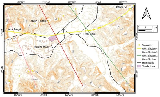
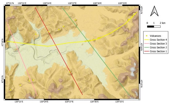
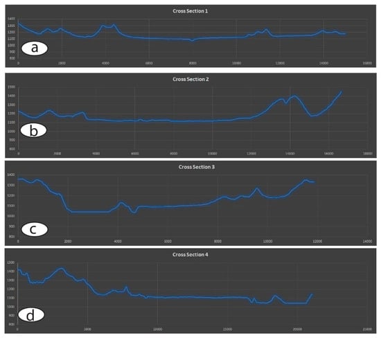
The study area is part of the Arxan–Chaihe volcanic field (Figure 1). It is a middle mountain area where Mesozoic basement rocks form fault-bound ridges [9] (Figure 1 and Figure 2). Between the ranges, broad flat-floored valleys are commonly filled with basaltic lava flows (Figure 3). The modern fluvial network gradually cut into the older lava surfaces forming canyons and broad alluvial fans in convulsions of major valley networks (Figure 1, Figure 2 and Figure 3). The region has recognizable volcanic geoforms of scoria cones and maar craters filled with lakes [3]. Scoria cones commonly host shallow lakes that are also part of the main landscape elements of the region, such as the Arxan Tianchi near Tianchi township. Preserved volcanoes clearly form vent alignments following the main NE-SW trending structural elements of the region (Figure 1 and Figure 2).
Figure 1.
Contour map of the study area (10 m intervals) based on ALOS-PALSAR 12.5 m resolution digital elevation model (DEM). Lines representing cross-section lines. Note the aligned volcanoes following the main morphological escarpments of the region.
Figure 2.
A relief map generated from the ALOS-PALSAR 12.5 m resolution digital elevation model demonstrates a simple morphological appearance of the study area.
Figure 3.
Four representative cross-sections across the study area clearly show the broad valley floors along phreatomagmatic volcanoes such, as Wusulangzi and Dichi Lake. Cross-section lines (a–d) are shown in Figure 1 and Figure 2. Note the gentle sloping landscape apparent on the roughly NW-SE trending cross sections (a–c) and a more or less EW trending cross section (d).
The region has a mountainous appearance, despite the fact that the general trends of the relief are clearly simple and distinguishable to flat-floored lava flow-filled valleys, main fault-bounded basement blocks, and a few elevated high landforms (Figure 2).
2.2. Satellite Imagery and Terrain Analysis
To locate young volcanic geoforms, such as scoria cones, maars, and lava fields, satellite imagery from the Sentinel Hub (https://apps.sentinel-hub.com/eo-browser/ accessed on 15 September 2022) was used. For basic terrain analysis, the free ALOS-PALSAR 12.5 m digital elevation model (DEM) (https://search.asf.alaska.edu accessed on 9 August 2022) was utilized.
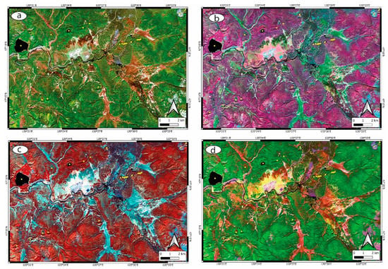
In this study, we utilized four Sentinel satellite datasets, such as the True Colour Composite, False Colour composite, and the Geology 8, 11, and 12, and 12, 11, and 2 composite images were used. Each of these images is sensitive to showing young volcanic landforms, unvegetated young lava flows, and a certain extent of volcanic ash-dominated regions.
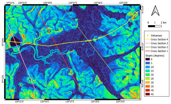
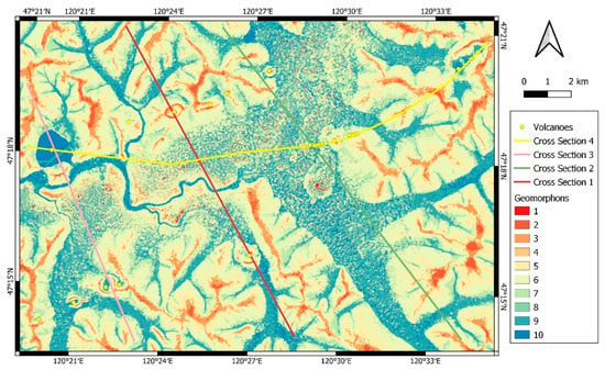
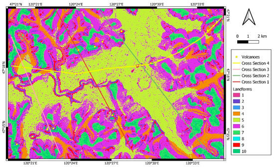
For basic terrain analysis, the Q-GIS software and its accompanying software modules (e.g., Grass GIS) (https://qgis.org accessed on 18 April 2022) were used on the available ALOS-PALSAR elevation data. We generated slope, geomorphon, and topographic position-based landform classification maps.
3. Results
Sentinel satellite imagery revealed that the young volcanic geoforms show up as distinct features on the images. Based on these maps, vents were identified (Figure 4a–d). It is evident that the lowermost elevation region, the main fluvial system within the Halaha River, hosts the youngest lava flow fields that erupted about 2000 years ago from the central part of the ACVF and inundated the region with lava flows. The identified vents aligned in two separate lineaments, each following valley networks visible on the landscape. The two NE-SW-aligned parallel volcano rows composed of volcanic geoforms exhibit similar satellite image texture; hence, they cannot be confidently assigned to specific time order. It seems active volcanism was apparent at various times within both lineaments. The only exception from this trend is the central part of the study area, where a short (<2.5 km) fissure-oriented volcano chain forms a slightly offset lineament (about 10 degrees offset from the main trends). Along this short fissure-aligned chain, scoria and lava spatter cones formed in the elevated part of the region, while a single explosion crater generated a maar that is currently one of the main geotouristic attractions of the area, the Dichi Lake. Dichi Lake is about 200 m in its diameter. Along its crater wall, lava flows exposed, while on its rim, large blocks of lava form some sort of ejecta ring. It is clear that the entire fissure system here predates the youngest lava flow emplacement of the Halaha River valley as it is associated with a relatively small lava field (about 4 km across) that functioned as a barrier against the youngest lava flows to move (Figure 4a–d).
Figure 4.
Sentinel satellite images of the study area, such as true light (a), false colour (b), geology 8, 11, 12 band composite (c), and geology 12, 8, 2 composite images (d). Note, especially on the (c) and (d) images, the young lava flow that fills the Halaha River valley. The volcanic landforms are clearly recognizable, especially their NE-SW-elongated fissure-oriented map view that is parallel with the main structural elements of the region.
A slope angle map generated from the 12.5 m resolution digital elevation data clearly shows the rugged but flat surface of the Halaha River Valley. The steepest slopes are in the SE-facing escarpment of basement rocks just on the true right side of the Halaha River, NW from Tianchi Township (Figure 1 and Figure 5). This escarpment is inferred to be a fault scarp, and the vents follow the same orientation in this region (Figure 5). The Dichi Lake area (Figure 1) and its lava flow field are marked by a morphological step in the SE edge of the Halaha River valley. This slightly elevated lava field diverted the main Halaha River lava flow. On the slope map, fissure-aligned vents are clearly visible, such as the Arxan Tianchi scoria cone adjacent vents to the NE and SW (Figure 5). Similar trend of vent alignment is apparent at the Dahei Go (Figure 1), where three distinct volcanos formed within 2 km fissure length. The closely spaced but small volcanic edifices built a volcano chain just NE from the Dichi Lake (Figure 5), where each small volcanic edifice amalgamated into a near-continuous crater row. This geomorphological aspect indicates that Dichi Lake volcanoes must have erupted simultaneously due to a rapidly opening fissure. Such an eruption scenario is a likely cause of the formation of the crater chains just NE from Arxan Tianchi. However, this region is more vegetated and likely to represent slightly older eruptions than those forming the Dichi Lake system.
4. Discussion
Based on direct field observations and satellite imagery, it is evident that the young volcanic landforms are aligned. Their alignment is in good agreement with the recognized morphostructural elements of the region, indicating a strong structural control of the magma ascent that fed the dispersed volcanism in the region. In addition to the field-wide vent alignments, the individual vents, as well as shorter groups, such as the Dichi Lake system, follow the same NE-SW trends of elongation and alignments. The Dichi Lake is a particularly great example that fissures likely opened rapidly, and simultaneously erupting vents produced mild explosive Hawaiian lava fountaining or Strombolian-style explosive eruptions. Once the feeder dike reached the low-lying and potentially water-saturated valley floors, a single explosive eruption took place to generate the Dichi Lake maar volcano. This eruptive mechanism that was revealed from the satellite imagery and morphological data accompanied by direct field documentation highlights the importance of the fissure-fed eruptions in the formation of this volcanic field. This information should play a more significant role in the geoeducation and geotouristic aspects of the Arxan UNESCO Global Geopark.
While the geopark has well-selected geosite “hotspots” (we use this term to define regions that are key geosites within the conservation area), and further analysis of the landscape by applying the geomorphon [10] (Figure 6) and the topographic position index-based landform classification [11] methods (Figure 7), we can state that the area has far more to offer. On both maps (Figure 6 and Figure 7), the fissure-aligned vents are clearly visible. Similarly, these landform classification methods captured the general structural elements of the region. This information could be used to develop geoeducation materials for visitors to help them to understand the landscape elements of the region. As the region has no characteristic landmarks other than some volcanic cones (that can be seen from distance only), generating landform classification maps could offer visitors a view to better understand the landforms and the potential geological and geomorphological processes standing behind their formations.
Figure 6.
The geomorphon map further demonstrates that the study area has monotonous landform classes within other landforms that are seemingly evenly distributed. Landform classes are (1) flat, (2) summit, (3) ridge, (4) shoulder, (5) spur, (6) slope, (7) hollow, (8) foot slope, (9) valley, (10) depression.
Figure 7.
Topographic position index-based landform classification of the study area. Note the similar trends of the landforms captured by applying the geomorphon theory. (1) Canyons, deeply incised streams, (2) mid-slope drainage and shallow valleys, (3) upland drainage, headwaters, (4) u-shaped valleys, (5) plains, (6) open slopes, (7) upper slopes/mesas, (8) local ridges/hills in valleys, (9) mid-slope ridges, small hills in plains, (10) mountain tops and high ridges.
5. Conclusions
In this report, we provided clear evidence for fissure-dominated volcanic eruptions in volcano-to-volcanic field scales as one of the key characteristics of the volcanic geology of the Arxan–Chaihe Volcanic Field. In addition to the direct field observations, the basic terrain and satellite image analysis demonstrated that the volcanism in the region is restricted to narrow bands that are parallel with the main structural elements of the region. This is interpreted to be strong evidence that the volcanism in the region had strong structural control, and this will likely define future eruption locations and eruption styles. This information, alongside the advanced landform analysis of the region, could form a strong core of geoeducation within the geotourism aspects of the Arxan UNESCO Global Geopark, highlighting the firm link between volcanism and structural geology of the continental lithosphere of this monogenetic volcanic field.
Author Contributions
Conceptualization, K.N. methodology, B.L. and K.N.; software, K.N.; validation, B.L.; formal analysis, K.N. and B.L.; investigation, K.N. and B.L.; resources, K.N.; data curation, B.L.; writing—original draft preparation, B.L.; writing—review and editing, K.N.; visualization, K.N. and B.L.; supervision, K.N.; project administration. K.N.; funding acquisition, K.N. All authors have read and agreed to the published version of the manuscript.
Funding
This research was partially funded by the Chinese Academy of Sciences and the Royal Society of New Zealand Scientist Exchange Program 2019.
Institutional Review Board Statement
Not applicable.
Informed Consent Statement
Not applicable.
Data Availability Statement
Not applicable.
Acknowledgments
Encouraging discussions with Vlad Zakharovsky, Ilmars Gravis, and Chris Twemlow are greatly appreciated. Julie Palmer and Alan Palmer are thanked for providing critical suggestions that we appreciate greatly.
Conflicts of Interest
The authors declare no conflict of interest.
References
- Németh, K.; Kereszturi, G. Monogenetic volcanism: Personal views and discussion. Int. J. Earth Sci. 2015, 104, 2131–2146. [Google Scholar] [CrossRef]
- Cui, X.G.; Xu, J.D.; Yu, H.M.; Zhao, B.; Yang, W.J. Understanding the Yanshan volcano eruption in the Chaihe-Arxan volcanic field, northeastern China. Arab. J. Geosci. 2021, 14, 2174. [Google Scholar] [CrossRef]
- Li, B.; Németh, K.; Palmer, J.; Palmer, A.; Wu, J.; Procter, J.; Liu, J. Basic volcanic elements of the Arxan–Chaihe Volcanic Field, Inner Mongolia, NE China. In Updates in Volcanology-Transdisciplinary Nature of Volcano Science; Németh, K., Ed.; IntechOpen: Rijeka, Croatia; London, UK, 2021; Available online: https://www.intechopen.com/chapters/73823 (accessed on 12 August 2022).
- Németh, K.; Wu, J.; Sun, C.; Liu, J. Update on the volcanic geoheritage values of the Pliocene to Quaternary Arxan–Chaihe Volcanic Field, Inner Mongolia, China. Geoheritage 2017, 9, 279–297. [Google Scholar] [CrossRef]
- Zhao, Y.W.; Fan, Q.C.; Bai, Z.D.; Sun, Q.; Li, N.; Sut, J.L.; Du, X.X. Preliminary study on Quaternary volcanoes in the Halaha River and Chaoer River area in Daxing’an Mountain range. Acta Petrol. Sin. 2008, 24, 2569–2575. [Google Scholar]
- Bai, Z.D.; Tian, M.Z.; Wu, F.D.; Xu, D.B.; Li, T. Yanshan, Gaoshan-two active volcanoes of the volcanic cluster in Arshan, Inner Mongolia. Earthqua. Res. Chi 2005, 19, 402–408, (In Chinese with English abstract). [Google Scholar]
- Zhao, Y.-W.; Zou, H.; Li, N. Geomorphology and geochemistry of the Late Cenozoic volcanoes in the Halaha River–Chaoer River volcanic fields, western Greater Hinggan Mountain Range, NE China. Geol. Soc. Lond. Spec. Publ. 2021, 510, 81–97. [Google Scholar] [CrossRef]
- Wang, L.; Tian, M.; Wen, X.; Zhao, L.; Song, J.; Sun, M.; Wang, H.; Lan, Y.; Sun, M. Geoconservation and geotourism in Arxan–Chaihe Volcano Area, Inner Mongolia, China. Quat. Int. 2014, 349, 384–391. [Google Scholar] [CrossRef]
- Meng, F.-c.; Safonova, I.; Chen, S.-s.; Rioual, P. Late Cenozoic intra-plate basalts of the Greater Khingan Range in NE China and Khangai Province in Central Mongolia. Gondwana Res. 2018, 63, 65–84. [Google Scholar] [CrossRef]
- Jasiewicz, J.; Stepinski, T.F. Geomorphons—A pattern recognition approach to classification and mapping of landforms. Geomorphology 2013, 182, 147–156. [Google Scholar] [CrossRef]
- De Reu, J.; Bourgeois, J.; Bats, M.; Zwertvaegher, A.; Gelorini, V.; De Smedt, P.; Chu, W.; Antrop, M.; De Maeyer, P.; Finke, P.; et al. Application of the topographic position index to heterogeneous landscapes. Geomorphology 2013, 186, 39–49. [Google Scholar] [CrossRef]
Disclaimer/Publisher’s Note: The statements, opinions and data contained in all publications are solely those of the individual author(s) and contributor(s) and not of MDPI and/or the editor(s). MDPI and/or the editor(s) disclaim responsibility for any injury to people or property resulting from any ideas, methods, instructions or products referred to in the content. |
© 2022 by the authors. Licensee MDPI, Basel, Switzerland. This article is an open access article distributed under the terms and conditions of the Creative Commons Attribution (CC BY) license (https://creativecommons.org/licenses/by/4.0/).
