Abstract
The Internet of Drone Things (IoDT) is a trending research area where drones are used to gather information from ground networks. In order to overcome the drawbacks of the Internet of Vehicles (IoV), such as congestion issues, security issues, and energy consumption, drones were introduced into the IoV, which is termed drone-assisted IoV. Due to the unique characteristics of the IoV, such as dynamic mobility and unsystematic traffic patterns, the performance of the network is reduced in terms of delay, energy consumption, and overhead. Additionally, there is the possibility of the existence of various attackers that disturb the traffic pattern. In order to overcome this drawback, the drone-assisted IoV was developed. In this paper, the bio-inspired dynamic trust and congestion-aware zone-based secured Internet of Drone Things (BDTC-SIoDT) is developed, and it is mainly divided into three sections. These sections are dynamic trust estimation, congestion-aware community construction, and hybrid optimization. Initially, through the dynamic trust estimation process, triple-layer trust establishment is performed, which helps to protect the network from all kinds of threats. Secondly, a congestion-aware community is created to predict congestion and to avoid it. Finally, hybrid optimization is performed with the combination of ant colony optimization (ACO) and gray wolf optimization (GWO). Through this hybrid optimization technique, overhead occurs during the initial stage of transmission, and the time taken by vehicles to leave and join the cluster is reduced. The experimentation is performed using various threats, such as flooding attack, insider attack, wormhole attack, and position falsification attack. To analyze the performance, the parameters that are considered are energy efficiency, packet delivery ratio, routing overhead, end-to-end delay, packet loss, and throughput. The outcome of the proposed BDTC-SIoDT is compared with earlier research works, such as LAKA-IOD, NCAS-IOD, and TPDA-IOV. The proposed BDTC-SIoDT achieves high performance when compared with earlier research works.
1. Introduction
The Internet of Drone Things (IoDT) was created to control the airspace using drones; it is also called UAVs (unmanned aerial vehicles) combined with the Internet of Vehicles (IoV), which is a highly promising technology and creates huge benefits in both industrial and academic research. The IoV is an Internet-connected, self-organizing vehicular network that is capable of performing effective communication, and it can provide high road safety and self-navigation. However, IoV-based networks suffer from certain flaws, such as link disconnections, improper resource allocation, and high computational costs. In order to overcome this drawback, unmanned aerial vehicles (UAVs) are combined with it.
Recently, VANETs were entered into super-fast networks with dynamically varying topology, which increased the energy consumption and routing overhead of the network. In order to overcome these drawbacks, drones were introduced in VANET-based networks. Drones are interconnected devices, so they can communicate among themselves. A drone maintains two network structures: UAV–UAV communication and UAV–infrastructure communication [1]. In general, drones are equipped with various sensors, cameras, GPS, signal transmitters, etc., and they are used for various applications, such as confidential communication, inaccessible surveillance, environmental observance, yield observance, farming, and disaster monitoring [2]. Drone-assisted VANETs maintain a heterogeneous structure, where the vehicular network is connected to the drones. The communication of this kind of network establishes vehicle-to-vehicle (V2V), vehicle-to-drone (V2D), and drone-to-drone (D2D) communication. Drone-aided VANETs provide more opportunities and functionalities to control network traffic. The major roles of drones are to provide temporal traffic indications, predict road traffic, define mobility patterns, pathway optimization, and intelligent vehicle connectivity [3]. Drones help to establish optimal places for ground vehicle communication [4], as applying drones to ground vehicle communication results in the increase in delay. So, it is essential to control delay using optimization in communication between the drones and the vehicles [5].
Drones were introduced in VANETs to improve the performance of VANETs in terms of congestion avoidance, energy consumption reduction, and security purposes. Due to the large-scale deployment of VANETs, it is very easy for attackers to enter into the network. Drones help to guarantee the integrity of the network [6]. They help to secure confidential information and the movement trajectories of the vehicles [7]. If the privacy of the network is high, then it becomes very complicated to attract vehicle users to enter into the network [8]. In order to achieve the complete benefits of the drone-aided VANET architecture, several issues need to be focused on. Initially, threats are high in VANETs because of their mobile nature. Various attackers can control the network during transmission. So, it is essential to improve the trust ability of the network. In a dynamic environment, it is difficult to control the congestion of the network. Due to high congestion, there is a possibility for the occurrence of high overhead and connectivity loss during communication. These are major issues that need to be addressed in drone-based VANETs. In this study, the challenges of drone-based VANETs are investigated, and the major contributions of this research study are as follows:
- In this paper, the main aim is to improve the effectiveness of the drone-based Internet of Vehicles communication by reducing the congestion and energy consumption and by increasing the security, which were considered the major drawbacks in earlier research. For that purpose, bio-inspired dynamic trust and congestion-aware zone-based secured community with hybrid optimization is performed.
- Initially, to improve the coverage area of the network, heterogeneous drone-based VANETs are constructed, which includes vehicles, cluster head (CH), and drones.
- To protect the network from the malicious activities and to reduce the energy consumption and delay in the proposed method, triple-layer trust construction, congestion-aware community construction, and hybrid optimization is performed.
- Initially, to improve the security, triple-layer trust construction is performed through a dynamic trust estimation process. Here, the trust for vehicle to CH, for CH to drone, and for drone to BS are concentrated.
- Secondly, congestion is controlled through a congestion-aware community construction method. Finally, in order to reduce energy consumption and routing overhead, hybrid optimization is performed with the combination of ACO and GWO algorithms.
- In the performance analysis section (Section 5), the evaluation of the proposed work is performed using various attacks such as flooding attack, insider attack, wormhole attacks, and position falsification attack. The considered parameters for the performance analysis are energy efficiency, packet delivery ratio, routing overhead, end-to-end delay, packet loss, and throughput.
2. Related Works
In this related work section, the drawbacks present in the drone-based vehicular networks are analyzed. The authors of [9] developed a method to improve the quality of service (QoS) of various VANET applications called data scheduling through game theory. Through this method, delay is reduced and throughput is increased. However, this method fails to reduce the routing overhead during transmission. The authors of [10] presented an approach called the collaborative network coverage enhancement scheme (CONEC) to cover the uncovered area. Via this method, optimal places are provided to UAVs using particle swarm optimization (PSO). The packet delivery ratio and throughput are improved using this method. However, using PSO in UAVs increased the overhead in the network. The authors of [11] introduced a novel approach, namely a bio-inspired and traffic-aware mix-zone placement model for a drone-based network. Through this method, the privacy level of the network is increased. The other parameters, such as overhead and efficiency, are not considered in this research. The authors of [12] proposed a secure and lightweight drone access protocol to reduce the running time cost and communication cost of the network. To provide security for the dynamically varying vehicles, deep learning algorithms are used, and it is based on the key exchange protocol with XOR operator and hash functions. The accuracy level is high in this network; however, it fails to achieve high efficiency during communication.
The authors of [13] presented an approach to improve the superiority and flexibility of the drone called a collaborative communication scheme, which was developed to solve the traffic-related issues in VANETs. Through this method, the throughput and packet delivery ratio of the network is improved. However, this method mainly concentrates on the optimization problem; it is not up to the level, so this increases the overhead. The authors of [14] presented a model to improve the efficiency of the drone communication in emergency areas. GPS-based geo-tracking and geographic navigation are performed to improve the routing performance, and a heuristic algorithm is implemented to improve the communication speed and performance as it helps to transmit the data in an optimal path. The authors of [15] proposed an adequate connection between drones with the help of improved particle swarm optimization (IPSO). Through this method, high coverage and quality is achieved, but it fails to concentrate on security and overhead. The authors of [16] proposed an efficient privacy preserving authentication method for IoDs. This method reduces the authentication cost and improves the privacy and efficiency of the network. However, there is no proof for the reduction in overhead. The authors of [17] presented a model to analyze the probability distribution of vehicles to drones in a bi-directional manner. This method reduces the network delay but fails to improve the efficiency, throughput, and delivery ratio. The authors of [18] developed a novel approach to reduce the energy consumption and delay called Non-Orthogonal Multiple Access (NOMA), which is mainly utilized for the process of bandwidth allocation. The additional methods which are used to improve the clustering-based UAVs network are K-means clustering and truncated Gaussian distribution. This method greatly reduced the power consumption and delay, but packet loss occurred due to the lack of security in the network. The authors of [19] proposed a proactive UAVs placement in RSU-assisted VANETs. The optimal UAV placement is performed using the particle swarm optimization (PSO) process, but it fails to achieve maximum efficiency during the process of communication.
The authors of [20] presented a UAVs-assisted VANETs-based edge detection, which is the deep-learning-based optimal deployment of the UAVs, mainly to reduce the energy consumption and delay of the network. However, due to multiple traffic jams, the packet loss in this network is moderate. The authors of [21] developed an effective communication model for the UAV networks through hybrid automatic repeat request protocol to control the congestion in the network. However, the communication is ineffective due to the lack of security. The authors of [22] proposed a reinforcement learning-based trajectory control for UAVs that increase the stability of the network by protecting the network from the jamming, but it fails to reduce the energy consumption. The authors of [23] proposed a bio-inspired UVDTN network to improve the quality of service (QoS) of the urban VANETs. The algorithms which are used in this process are social spider optimization (SSO) and store carry forward (SCF) process. The results show that this method achieves low delay and overhead but fails to achieve high efficiency. The authors of [24] proposed a NOMA-based resource allocation in vehicular communication using game theory. The simulation results achieve moderate efficiency.
The authors of [25] developed an authentication and key agreement (AKA) scheme to improve the privacy of the drones-based network. Through this method, the communication and computational cost are reduced. However, it fails to concentrate on other parameters such as efficiency, overhead, throughput, etc. The authors of [26] introduced a method to avoid the congestion called fog-assisted smooth packet distribution. This method improves the packet delivery ratio and reduces the overhead but fails to improve the security of the network. The authors of [27] developed a trust-and-priority-based drone-assisted IoV. Through this method, the overhead and delay are reduced, packet delivery ratio and efficiency are high, but the throughput achieved by this network is moderate. The advantages and disadvantages of these earlier studies are shown in Table 1.

Table 1.
Earlier Research Analysis.
By analyzing all these earlier studies, it is understood that the major drawbacks in the drone-based VANETs are congestion, high overhead, and security. In [25], AKA authentication is performed, which fails to achieve lower congestion and overhead. Hence, the major focus is security, but the huge number of vehicles with dynamic mobility pattern leads to high delay, congestion, and packet loss. The authors of [26] focus on the congestion control of the vehicles during the process of communication which provides a way to some of the misbehaviors that is reflected in the increases of packet loss, overhead, and energy consumption. In [27], the trust and priority of the network is the focus, but there is no optimal path between the source and the destination during communication, which leads to ineffective communication. These are major drawbacks from the earlier research works. So, in this research, Bio-inspired Dynamic Trust and Congestion-Aware Zone-based Secured Internet of Drone Things (BDTC-SIoDTs) is proposed which concentrates on security, congestion avoidance, and overhead control, and a detailed description of the proposed BDTC-SIoDTs is given in the following sections.
3. Preliminaries
The proposed system is designed in terms of including the data communication among the Internet of Drone Things (IoDTs), vehicle-to-CH (V-CH) communication, CH-to-drone (CH-D) communication, and drone-to-drone (D-D) communication, and the transmission is concluded by transmitting the information to the Base Station (BS). Additionally, it shares the information about the drone routing model as well as the design threads present in IoDTs. The systematic structure of the network is shown in Figure 1. At the initial stage, these communication models are elaborated, then following that, the designed routing protocol for these communications are discussed. The general transmission structure is that the vehicle transmits the information to the CH; subsequently, the CH transfers the data to the drones. Finally, the BS collects the data from the respective drone. The transmission region is divided into zones, and one or two drones will monitor each zone. Some of the special qualities of a drone are that it is able to cover a huge coverage space and it monitors the dense traffic conditions; hence, it contains its own Global Positioning Systems (GPS) as well as the digital maps.
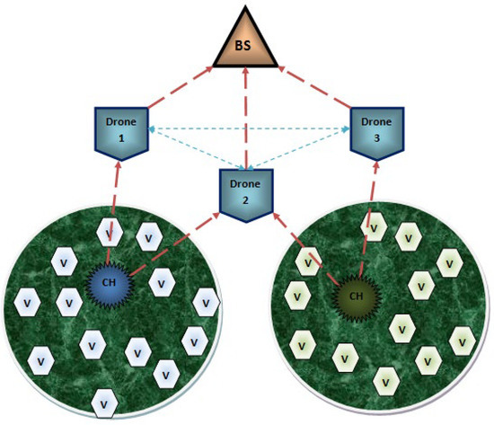
Figure 1.
Systematic Structure.
3.1. Internet of Vehicles
Each vehicle present in the system communicates through a wireless medium. The inbuilt components of each vehicle consist of an on-board unit (OBU), tamperproof device (TPD), and graphical user interface (GUI). In this type of communication model, vehicle–vehicle communication does not occur. All the vehicles are designed to transmit the data packets to the cluster head (CH). The CH collects the data packets from the vehicles which are present in its coverage space and then continues the process further.
3.2. Vehicle-To-CH (V-CH) Communication
A cluster head (CH) is created in the network to aggregate all the data packets from the vehicles in short-range communication so as to reduce the traffic congestion. Following that, the aggregated data packets are transmitted to the drones that are present in the transmission range of the CH.
3.3. CH-To-Drone (CH-D) Communication
The collected information from the vehicles is transmitted from the CH to the drone. Hence, the drone does not require any infrastructure to provide service to the CH because the principle of BS is to provide the essential utilities to process the communication among the network, and it also avoids direct data collection. Next to the BS, the drone maintains high energy so that it is able to cover huge densely populated areas. All the communication from the CH to BS is only through the drones. Due to its high quality, it is able to build an obstacle-free environment. The routing process of CH-D is described in Figure 2.
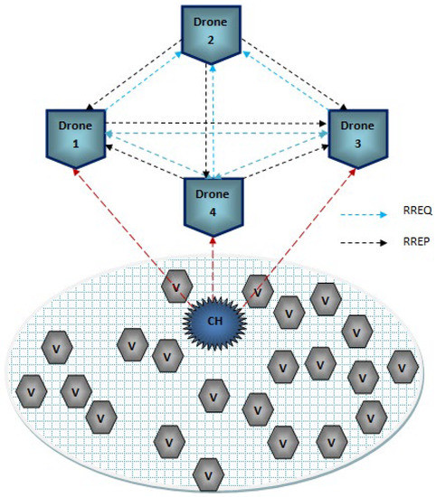
Figure 2.
Communication among CH and Drone.
3.4. Drone-To-Drone (D-D) Communication
In order to reduce the obstacles handled by the vehicles, drones are introduced to manage the huge dynamic varying constraints. Drones are highly qualified to solve the traffic-related issues of vehicles due to its routing model. In general, drones are unmanned aerial vehicles (UAVs) which are controlled using the onboard computers. Drones are fully automatic and are able to work without any intervention from humans. Some of the inbuilt components of drones are kinds of smart IoT devices such as distance sensor, ultrasonic sensor, thermal sensor, GPS system, motors, transmitter and receiver, battery, range measuring sensor, radio sensor, and chemical sensor. Reliable transmission can be easily achieved using the drones in the network. There is some ideal process present during the process of data transmission among the drones which is not similar to the transmission among vehicles or CHs. Drones support very limited protocols, which can establish connectivity in a smart way.
3.5. Drone Routing
The traditional routing model is not suitable for drone routing; hence, hybrid routing [28] is used, which is the zone routing protocol (ZRP). This protocol is mainly designed to reduce the routing overhead, where the control packets maintain a static packet size. Here, connectivity is established using a prediction approach. The network coverage space is divided into several zones, and each zone is monitored by one or two drones. The major phases of the protocol are route request (RREQ), route reply (RREP), route expiration (RE), and route error (RERR). The packet structure of the ZRP routing protocol is shown in Figure 3.
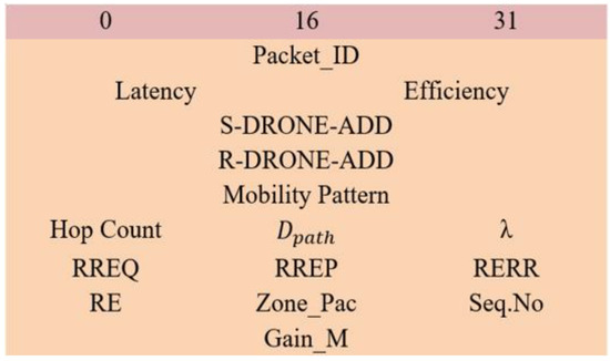
Figure 3.
Packet Structure of ZRP Protocol.
In the ZRP protocol, the sender broadcast the RREQ packet, the control packet size ranges from 0 to 31, the S-DRONE-ADD represents the sender drone address, and the R-DRONE-ADD represents the receiver drone address. The inbuilt parameters, which are calculated directly from the control packets, are latency and efficiency. The possible pathway to reach the receiver is noted in the mobility pattern. Once the delay is so high or the efficiency of the packet reaches below its threshold, then the packet gets dropped automatically. Hop count represents the intermediate hops total count of the packet. Additionally, some other basic information is packet_ID, sequence number (Seq. No), and zone packets (Zone_Pac). After the broadcast of the RREQ packet, through certain hops, the packet must reach the receiver. Using certain parameters, the hops will update the packet such as momentum, latency, location, travel path, and efficiency. Here, RE represents the route expiration, and it happens on certain conditions when the efficiency of the route reaches below its threshold efficiency. Once the RREQ packet reaches the receiver, the total gain measurement () is calculated, which is mathematically expressed below:
In Equation (1), the denotes the gain obtained during the connectivity of the route, denotes the total number of routes measured by the single drone, λ denotes the actual allocation of the drone, and the latency and efficiency are the core parameters used for the measurement of gain. Following the gain measurement, the receiver generates the RREP packet and sends it back to the sender. The optimal path to transfer the RREP packet is chosen as the route with the highest gain measurements. The RREP packet also maintains the general information, such as packet_ID, sequence number (Seq. No), and zone packets (Zone_Pac). During the process of transmission of the RREP packet to route, expiration may occur at the time the route revival model is initiated and select the route with the next best gain measurement to transmit the RREP packet. If any connectivity issues occur due to the geographical changes of the drones at that time, a route error (RERR) packet is generated so as to recreate the route discovery. Due to this process of zone creation, link failures are easily identified. The process of drone routing is described in Algorithm 1.
| Algorithm 1. Drone Routing |
| Each S-DRONE broadcasts RREQ, Type → Packets, Details → Packet_ID, Latency, Efficiency, Hold → Mobility Pattern, Seq. No = extract from packet, Hop Count = extract from packet, = extract from packet, Begin_If { Generate RREQ then broadcast, Continue until reaches the destination, } end_if Else declare RE Gain calculation according to Equation (1) End |
3.6. Thread Model
In a vehicle-based network, massive devices get interlinked to perform the required operation according to their application. For that reason, it is easy for the attacker to introduce several security threads here to misuse confidential information. So, it is essential for any kind of VANET network to ensure the security level. In this research, the considered attacks for analysis are flooding attacks, insider attacks, wormhole attack, and position falsification attacks.
3.6.1. Flooding Attack
In general, flooding is a kind of attack that generates extra traffic that is reflected in the increase in bandwidth, energy consumption, and so on [29]. Data flooding increases the routing overhead by generating unwanted packets and broadcasting those packets to all the vehicles in the network. In route flooding, the malicious vehicles transmit false route requests to their neighbors so that the data can get lost by sending it to a non-existing vehicle.
3.6.2. Insider Attack
Insider attack directly affects the OBU system of the vehicles, and it copies the identity certificate of any vehicle so that the attacker can easily join the network [30]. Therefore, the OBUs become fully unsafe. Using this attacker makes it possible to monitor the other vehicles, so that the attacker can hack any vehicle using that identity certificate to collect the required material from it. After collecting the material, the attacker can replicate any innocent vehicle and then vanish from the network.
3.6.3. Wormhole Attack
This attack performs a topology modification operation among the vehicles and provides a false shortest path from the source to the destination during the process of communication, which is reflected in the increase in traffic and congestion in the network [31]. As a result, during data transmission, an attacker vehicle summarizes the information and transmits it to the cooperative vehicle. Then, two attackers transmit the information through a false optimal path which acts as a tunnel secret path so that the information will only transfer through the tunnel path and will not get broadcasted as normal information.
3.6.4. Position Falsification Attack
Creating false positions in VANETs is a serious issue that directly affects network safety applications. Hence, in general, VANETs-based applications highly trust the reliable positioning system of VANETs. This attack is reflected in the reduction in packet delivery ratio performance and affects the stability as well as the reliability of the system of VANETs.
4. Bio-Inspired Dynamic Trust and Congestion-Aware Zone-Based SIoDTs (BDTC-SIoDTs)
The proposed BDTC-SIoDTs is the combination of dynamic trust estimation, congestion-aware community, and hybrid optimization methods. At the initial stage, dynamic trust estimation is performed. It is the triple-layer model which provides trust on three levels, which are trusted for vehicle to CH, for CH to drone, and for drone to BS. Secondly, congestion-aware community construction is mainly introduced to predict the congestion occurrences in the network, so it becomes very easy to analyze and avoid it. Finally, hybrid optimization is preceded by the combination of ant colony optimization (ACO) and grey wolf optimization (GWO). All these concepts are explained elaborately in sequential order, and the schematic structure is given in Figure 4.
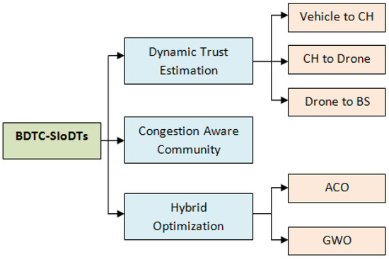
Figure 4.
Schematic Structure of the Proposed BDTC-SIoDTs.
4.1. Dynamic Trust Estimation
The process of dynamic trust is the triple-layer trust construction. They are trusted for vehicle to CH, for CH to drone, and for drone to BS.
4.1.1. Trust for Vehicle to CH
Trust calculation during the process of data transfer between the vehicles and CH is initiated. The presented trust model utilizes the shortest trust value calculation between the vehicles and CH by considering the attributes such as packet forwarding ratio, received ratio, trust value set, and the weight factor. The mathematical expression for the shortest trust calculation between the vehicle and CH is shown below:
In Equation (2), n denotes the number of trust attributes, denotes the weight of metric i by the vehicle to the CH, denotes the trust value set by the vehicle to the CH, denotes the packet forwarding ratio by the vehicle to the CH, and denotes the packet received ratio by the vehicle to the CH. Using this equation, the CH measures the trustworthiness of the vehicle. Here, the calculation for the packet forwarding ratio and the received ratio is given below:
In Equations (3) and (4), denote the successful forwarding and receiving rate of the message, and denote the unsuccessful forwarding and receiving rate of message. To measure the aggregated shortest trust value of each vehicle that transfers the data to the CH, the number of neighbor’s s are considered. The mathematical expression for the calculation of aggregated shortest trust value is shown below:
Then, the total trust measure based on the final weight factor is given below:
In Equation (6), the terms α and β are the constant values used for the experimental purpose, and it satisfies the condition α + β = 1.
4.1.2. Trust for CH to Drones
At the initial stage, the vehicle transmits the information to the CH, then the CH transfers that information to the BS through the drones present in the coverage area of the CH. At the time of receiving the data from the CH, drones will carry out safety measures. It happens after receiving the message from CH and before transferring that to the BS. Already the network is occupied with flooding, insider, wormhole, and false positioning attacks. Among them, the flooding attack and wormhole contain the possibility to affect the data transmission among the CH and the drones. To ensure accuracy, the system introduces a trust assessment here. After receiving the data from the CH, the drone undergoes the trust evaluation. The mathematical expression for the calculation of the trust evaluation in the drone is given below:
In Equation (7), according to the history of CH, it may have both optimistic and harmful verification during message transmission. The trust evaluation is performed according to the measurements. The terms denoted the optimistic verification and the overall optimistic history of the node CH; similarly, denoted the harmful verification and the overall harmful history of the node CH. Through the above equation, the trust estimation for CH is measured. Each drone maintains its trust table, which consists of the trust history of the CH data transmission at each instant of time.
4.1.3. Trust for Drones to BS
In the final higher-level trust calculation, the trust measure is performed between the drones and the BS. The drones transmit the calculated data to the BS present in its coverage area to find and evaluate the final aggregated shortest trust value. At the level, there is a possibility of a flooding attack, so a trust calculation at this level is also essential. According to the consideration neighbor drones (nd), the aggregated shortest trust estimation between the drones and the BS is mathematically expressed below:
4.2. Congestion-Aware Community
A congestion-aware community is designed in terms of analyzing the road traffic in the densely populated area and discovering a suitable path for data transmission [32]. The network’s similar functions are analyzed, and the dynamic trust-based clustered community is created. Each cluster is represented as a separate community, and it consists of basic cluster quality as well as irregular vehicle allotment. The structure of the congestion-aware cluster community is shown in Figure 5. The real-time congestion is analyzed using certain parameters, such as vehicle information, and momentum variation inside the cluster where the vehicle which is located at the shorter distance to the CH directly transmits the data, while the vehicle which has a high density to the CH transfers the data to the CH with the help of the intermediate vehicles. In a real road condition, vehicle distribution in a densely populated area turns out to be highly uneven. For this reason, even an aggregated network creates traffic congestion. Congestion-aware clustered community creation results in congestion avoidance in the densely populated area. The initial stage of this message is to transmit a warning message when high variation is present in momentum and there is density among the vehicles, which are measured in terms of time variation. The congestion inside each cluster community is captured, and the warning message is transmitted to the CH. Secondly, using the bio-inspired optimization method, the optimal path is found to transfer the data from the vehicles to the CH. The process of finding the optimal path is elaborated in the next section.
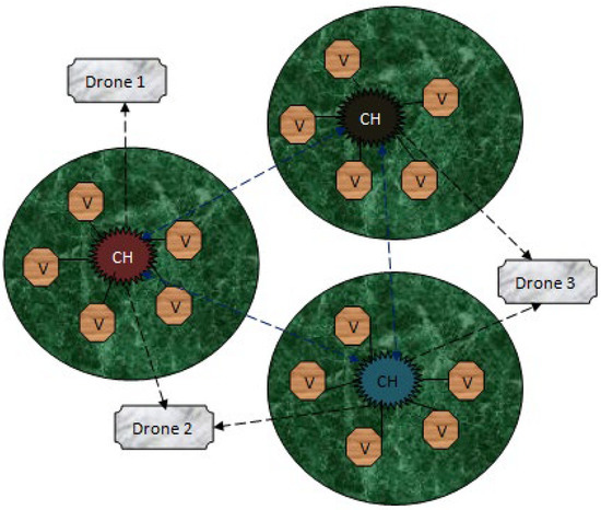
Figure 5.
Congestion-Aware Cluster Community.
4.3. Congestion-Aware Community
For the process of optimal path selection for this network, a bio-inspired hybrid optimization model is utilized, which is the combination of ant colony optimization (ACO) and grey wolf optimization (GWO). The ACO algorithm is one the most familiar biological ant-based models where ants search for food using pheromone deposition during the movement from one place to another. According to the pheromone quality, the shortest path from the source to the destination is decided. In the GWO algorithm, the social characteristics of the grey wolf are considered, and certain parameter analysis with random values of vehicle count, coverage area, and density of the grid followed by cluster formation and cluster head (CH) creation is performed. In this network, the CH selection is based on the dynamic trust-based clustering approach, which is already shown in Section 4.1. The CH is chosen, and it manages the whole cluster and also provides a way for vehicles to newly join the cluster and leave the cluster; this is because the vehicles are dynamic in nature and one vehicle cannot be a member of two clusters. These are the general processes of the ACO and GWO algorithms. To find an optimal path at high speed, dynamically varying network hybrid optimization is essential to achieving better performance. Here, at the initial stage, the ACO algorithm is used to find the shortest path, followed by the GWO algorithm which provides an optimal path according to the calculation of vehicles leaving and joining the cluster; moreover, it maintains the minimum vehicle count inside the cluster.
4.3.1. Initial Path Finding Using ACO Algorithm
The principle of ACO is derived from the mutual characteristics of the ants. The food search process of the ant is used to find the optimal path. This initiates the travel from the nest to discover the food, and when it finds the food, it proceeds to transfer the food to the nest [33]. In this travel time, the ant will deposit an evaporative solution called a pheromone. Using this chemical, the other ants follow this path to transfer the rest of the food to the nest. At the initial stage, ants travel in various paths, and at the final stage once the food is found, according to the quantity of the pheromone deposition, the best optimal path is chosen. In our model, the vehicles are represented by ants that fill up the pheromone on the traveling paths. Here, congestion is measured in terms of the quantity of pheromone deposition on each road. Each road has permission to utilize the deposition of up to 80% of its threshold value, and once it has reached that stage automatically for further transmission, the next best path is shown to avoid congestion. The mathematical expression to calculate the pheromone initialization at the starting stage when the time is zero is shown below:
In Equation (9), represents the amount of pheromone present from the source to the destination according to end-to-end distance, α is a constant value of (0,1), and it is measured only for analysis purposes. The process is repeated until the best result is found. When the vehicle s chooses the vehicle, the current pheromone deposition at that instant of time is expressed below:
where
In Equation (10), the term is the pheromone deposition between the two ends of the source and the destination, and is the overall cost of the transmitting vehicle and both standard constants, which helps in the measurement of the pheromone deposition. Following this, the calculation of pheromone evaporation proceeded. This process is mainly used to avoid confusion in path findings. The path which consists of a lower quantity of pheromone deposition gets evaporated automatically in some instances. The mathematical expression for the calculation of pheromone evaporation is shown below:
In Equation (12), β is represented as a constant value of [0, 1] for analysis purposes. After this process, the current status of the pheromone is updated immediately. The mathematical expression for the calculation of pheromone updates is shown below:
where
In Equation (13), is total ant count which is needed to transfer the data from the source to the destination, is represented by a constant value of [0, 1] for analysis purposes. The entire process of this optimization method is illustrated using Algorithm 2.
| Algorithm 2. Congestion-Aware Community |
| START Initiate procedure Allotment of proper time interval for iteration Process 1—initial pheromone deposition Process 2—Pheromone Evaporation Process 3—Update the pheromone Execute the results at each instant of time Finalize the schedule End procedure STOP |
Using this ant-based optimization technique, an optimal path is chosen in the network at the initial stage. After reaching a certain degree of vehicles joining and leaving the cluster simultaneously at each instant of time, the selection of the optimal path gets updated using the grey wolf optimization algorithm. The process of the grey wolf optimization algorithm is elaborated in the following section.
4.3.2. Standard Optimal Path Using GWO Algorithm
The principle of the GWO algorithm is designed according to the mutual characteristics of the grey wolves. This kind of optimization method generates the parameters randomly at the initial stage [34]. In this research work, the GWO algorithm is used to find the optimal path at the intermediate state of the data transfer. Hence, the effective CH is already chosen using the dynamic trust-based CH selection method. Currently, the parameters which are considered for the selection of an optimal path are momentum, density, pathway, location, and so on. The CH is chosen to monitor the entire cluster so that the vehicle leaving the cluster and joining the cluster are managed at each instant of time because any vehicle in the network can select one CH to monitor it. The sequential workflow of GWO optimization is described in Figure 6.
Figure 6.
Workflow of the GWO Optimization.
At this stage, the GWO algorithm helps to optimize the cluster members with a maximum of (10–17) in numbers. There are certain parameters which are considered for this optimization technique: denotes the gender (male or female) and also acts as a leader. The second position is (male or female); wolves help the leaders in the process of decision making. The final position is ; the wolves which are present in this position are spitted as spies, guards, predators, and caretakers. These wolves work hard to protect the pack. The hierarchical order of the wolves is represented in Table 2 below
Table 2.
Hierarchical Order of the Wolves.
According to this hierarchical order, the hunting process is continued. The mathematical expression for all the types of wolves for encircling is shown below:
Every term used for this hunting process is a vector term. At the end of this encircling process, the leader wolves () force the prey to initiate the movement, and the value of lies between (5 and below). At the same time, the initial vector A is less than 1. So, the mathematical expression for the leader is forced; the movement is shown below:
The whole process of finding the best path for transmission at the intermediate stage is explained using the pseudo-code below.
Pseudo code for GWO-based intermediate optimal path-finding process:
Step 1—Vehicle location identification in the densely populated area.
Step 2—The vehicle maintains random momentum, density, and velocity.
Step 3—The topography is random, and each vehicle maintains its secret ID.
Step 4—Population initialization Xi,
for
End for
Step 5—Iteration calculation I.
For
End for
Step 6—Fitness Calculation according to the type of the wolves:
- = Leader—Finest solution provider.
- = Leader Helper.
- = Helps for other additional function.
Step 7—Finest search calculation = .
Step 8—Update the wolf’s position and time ().
5. Results and Discussion
For the process of simulation experimentation, NS2.35 software is used which consists of two input languages, such as Tool Command Language (TCL) used as a front-end programming language and C++ as a back-end programming language. To view the structural outcome, NAM (Network Animator) is used. To analyze the results, a trace file is generated. The formula used to separate particular data from the trace file is performed using the Perl file and awk files. The simulation coverage area is set as 2000 m × 3000 m. Additionally, the number of vehicles present in the network is 200 vehicles. The considered input parameters for the process of simulation are given in Table 3 below.
Table 3.
Simulation Parameters.
The parameters which are considered for the analysis of the results are energy efficiency (%), packet delivery ratio (%), routing overhead (packets), end-to-end delay (packets), packet loss (packets), and throughput (kbps). The evaluation proceeds through two scenarios: the first scenario is according to the variation of the calculated performance speed of various attacks, such as flooding attacks, insider attacks, wormhole attacks, and position falsification attacks, of the proposed BDTC-SIOVTs. In the second scenario, the considered parameters of the proposed BDTC-SIOVTs are compared with earlier works such as LAKA-IOD [16], NCAS-IOD [17], and TPDA-IOV [18].
5.1. Performance Analysis according to the Speed and Attacks
The parameters used for this analysis concerning the varying speed from 50 km/h to 300 km/h are energy efficiency, packet delivery ratio, routing overhead, end-to-end delay, packet loss, and throughput. The performance analysis of the proposed BDTC-SIOVTs is performed using the following attacks. Figure 7 clearly indicates the energy efficiency calculation of the proposed BDTC-SIOVTs according to varying speeds, and it is compared between various attacks. From the graph, it is understood that the performance of proposed BDTC-SIOVTs is high for attacks such as flooding attacks, insider attack, and wormhole attack, and the efficiency of the proposed BDTC-SIOVTs is low in the case of the position falsification attack. The proposed BDTC-SIOVTs is the combination of dynamic trust and hybrid optimization methods which play a better role in the other attacks but still need some betterment in terms of position falsification attacks.
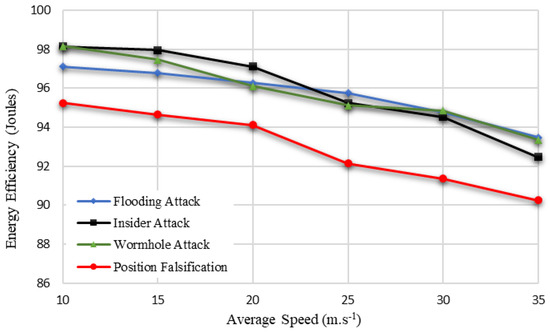
Figure 7.
Energy Efficiency based on varying speed of vehicles.
The proposed BDTC-SIOVTs produced a high packet delivery ratio with attacks such as flooding attacks and insider attacks. The packet delivery ratio of the proposed network with the wormhole attack and position falsification attack are comparatively low when compared to others, and it is demonstrated in Figure 8.
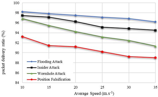
Figure 8.
Packet Delivery Ratio based on varying speed of vehicles.
Hence, the core idea of the proposed BDTC-SIOVTs is to reduce the overhead so that the idea of dynamic trust-based clustering and the hybrid optimization is combined. The hybrid optimization method greatly helps to reduce the routing overhead even during the presence of attacks in the network. The proposed BDTC-SIOVTs produced a low routing overhead for all the attacks, which is shown in Figure 9.
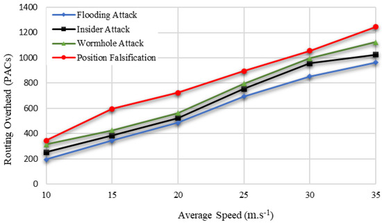
Figure 9.
Routing Overhead based on varying speed of vehicles.
The proposed BDTC-SIOVTs produced a low end-to-end delay with attacks such as flooding attacks and insider attacks. The end-to-end delay of the proposed network with wormhole attacks and position falsification attacks is comparatively high when compared others, and it is graphically represented in Figure 10.
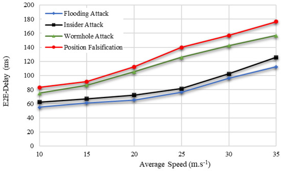
Figure 10.
End-to-End Delay based on varying speed of vehicles.
The proposed BDTC-SIOVTs are the clustered drone-based model that highly concentrates to reduce the loss of packets so that it can support the transmission of confidential messages. The packet loss calculation of the proposed BDTC-SIOVTs is low with all the attacks, and it is shown in Figure 11.
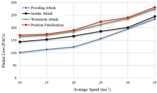
Figure 11.
Packet Loss based on varying speed of vehicles.
Hence, throughput is considered to be an important parameter because it represents the overall quantity of data transmission and its ability. So, the perfect network must provide high throughput even in the presence of any kind of attacks. This is highly concentrated in the proposed BDTC-SIOVTs. From Figure 12, it is proved that the throughput utility is high for the proposed BDTC-SIOVTs for all types of attacks. This is the major advantage of the proposed BDTC-SIOVTs method. A detailed discussion of the results is given in the following section.
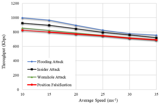
Figure 12.
Throughput based on varying speed of vehicles.
5.2. Subsection Dynamic Trust Estimation
In this section, the considered parameters such as energy efficiency, packet delivery ratio, routing overhead, end-to-end delay, packet loss, and throughput are analyzed in detail concerning speed (10–35 m.s−1), with the presence of certain attacks such as the flooding attack, insider attack, wormhole attack, and position falsification attack. The simulation values are shown in Table 4 and Table 5 below.
Table 4.
The values of Energy Efficiency, Packet Delivery Ratio, and Routing Overhead concerning varying speed and attacks.
Table 5.
The values of End-to-End Delay, Packet Loss, and Throughput concerning varying speed and attacks.
The efficiency in terms of attacks is flooding attack (97% to 93%), insider attack (98% to 92%), wormhole attack (98% to 93%), and position falsification attack (95% to 90%). From this measure, it is understood that an increase in speed reduces the efficiency of the network. The proposed method produced high efficiency with the presence of certain attacks such as flooding attacks, insider attacks, and wormhole attacks. Unfortunately, the efficiency received with the position falsification attack is a little low compared with the other attacks.
The increase in speed reduces the packet delivery ratio, which in terms of attacks, are flooding attacks (98% to 96%), insider attacks (97% to 94%), wormhole attacks (96% to 91%), and position falsification attacks (93% to 89%). The proposed BDTC-SIOVTs produced a high packet delivery ratio with the presence of certain attacks such as flooding attacks, insider attacks, and wormhole attacks. However, the ratio received with the position falsification attack is a little low compared with the other attacks. The increase in speed increases the overhead, which in terms of attacks, are flooding attack (196 to 964) packets, insider attack (254 to 1025) packets, wormhole attack (316 to 1125) packets, and position falsification attack (345 to 1245) packets. The proposed BDTC-SIOVTs produced a low overhead for all the attacks present in the network.
The increase in speed increases the delay, which in terms of attacks, are flooding attack (55 to 112) ms, insider attack (62 to 125) ms, wormhole attack (75 to 156) ms, and position falsification attack (83 to 176) ms. The proposed BDTC-SIOVTs produced a low delay for all the attacks present in the network. However, there is a variation in the attack performances. The proposed BDTC-SIOVTs produced much better results for flooding and insider attacks when compared with the wormhole and position falsification attack.
The increase in speed increases the packet loss, which in terms of attacks, are flooding attacks (102 to 235) packets, insider attacks (144 to 245) packets, wormhole attacks (165 to 275) packets, and position falsification attacks (171 to 282) packets. The proposed BDTC-SIOVTs produced a low loss of packets for all the attacks present in the network. The increase in speed reduces the throughput, which in terms of attacks, are flooding attacks (998 to 756) kbps, insider attacks (925 to 721) kbps, wormhole attacks (857 to 694) kbps, and position falsification attacks (825 to 691) kbps. The proposed BDTC-SIOVTs produced a high throughput for all the attacks present in the network, but according to the increase in speed, there is some gradual reduction in throughput.
5.3. Comparative Analysis according to Varying Number of Vehicles
The parameters used for the vehicle-based analysis are energy efficiency, packet delivery ratio, routing overhead, end-to-end delay, packet loss, and throughput. The performance of the proposed BDTC-SIOVTs is compared with earlier research such as LAKA-IOD, NCAS-IOD, and TPDA-IOV.
In Figure 13, it is attested that the energy efficiency of the proposed BDTC-SIOVTs is higher than the earlier methods. The cause for this achievement is that the proposed BDTC-SIOVTs are the combined enhanced trust-based clustering and hybrid optimization. This optimization method is the permutation of the ACO and GWO algorithms, which helps to overcome the drawback in the high-speed VANETs.
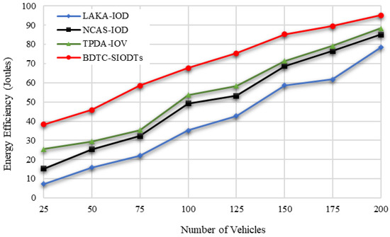
Figure 13.
Energy Efficiency based on number of vehicles.
In cluster-based VANETs networks, cluster has a major role in data gathering. So, it is essential to secure cluster communication from the external environment. For that reason, in the proposed BDTC-SIOVTs, dynamic trust-based clustering is initiated so that the packets which get transmitted through the CH are highly secured and there is no way for packet loss to be reflected in the increase in the packet delivery ratio of the proposed BDTC-SIOVTs, which is illustrated in Figure 14.
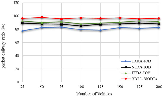
Figure 14.
Packet Delivery Ratio based on number of vehicles.
From Figure 15, it is understood that the proposed BDTC-SIOVTs provide a noteworthy decrement in the overhead performance when compared with others. This is because, in the proposed BDTC-SIOVTs, the data aggregation is performed through CHs and drones. The trust model which is used here is highly dynamic and effective. So, it is very hard for the external force to trouble this network and collect the information. Additionally, it is a high-speed VANETs so even with congestion, overhead can occur. To escape from this condition, hybrid optimization is used. Congestion will occur during the initial stage of data transfer and when vehicles leave and join the cluster. Both these conditions are monitored by the ACO algorithm and GSO algorithm. As the result, the overhead produced by the proposed BDTC-SIOVTs is lower than the LAKA-IOD, NCAS-IOD, and TPDA-IOV methods.
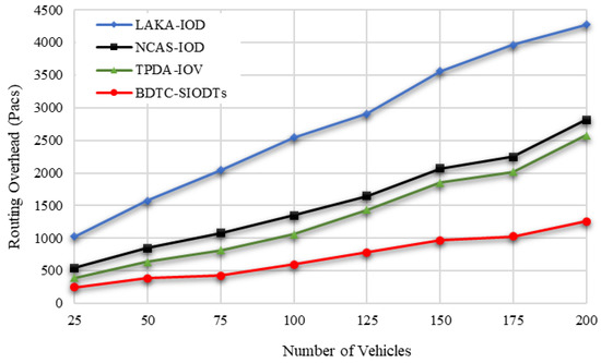
Figure 15.
Routing Overhead based on number of vehicles.
Due to the high overhead, the end-to-end delay is increased. Hence, the BDTC-SIOVTs method produced low overhead, which is reflected in the lower performance of the delay when compared with the earlier works, which are shown in Figure 16.
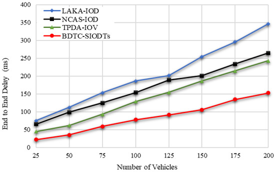
Figure 16.
End-to-End Delay based on number of vehicles.
Here, in the proposed BDTC-SIOVTs for the initial transmission, ant-based optimization is used and when vehicles leave the cluster and join another cluster, GWO optimization is used. This shift greatly controls the routing overhead of those results in the reduction in packet loss during transmission, which is represented in Figure 17.
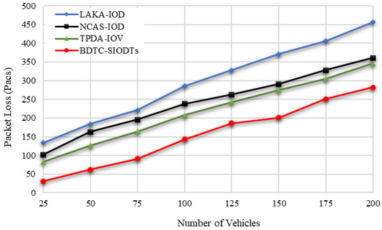
Figure 17.
Packet Loss based on number of vehicles.
From the graphical outcome in Figure 18, it is proved that the throughput achieved by the proposed BDTC-SIOVTs is higher than the others. A detailed discussion of the results is given in the following section.
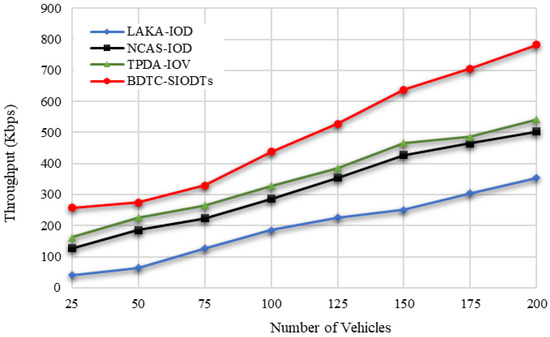
Figure 18.
Throughput based on number of vehicles.
5.4. Results and Discussion according to Varying Number of Vehicles
In this section, the considered parameters such as energy efficiency, packet delivery ratio, routing overhead, end-to-end delay, packet loss, and throughput are analyzed in detail concerning vehicles. The simulation values are shown in Table 6 and Table 7.
Table 6.
The values of Energy Efficiency, Packet Delivery Ratio, and Routing Overhead concerning vehicles.
Table 7.
The values of End-to-End Delay, Packet Loss, and Throughput Concerning vehicles.
In terms of the number of vehicles, the energy efficiency measured by the pro-posed BDTC-SIOVTs is 95%, and for the earlier works, it is LAKA-IOD (78%), NCAS-IOD (85%), and TPDA-IOV (88%). So, it is understood that the proposed BDTC-SIOVTs achieve 7% to 17% better energy efficiency when compared with the earlier works. According to the number of vehicles, the packet delivery ratio measured by the proposed BDTC-SIOVTs is 96%, and for the earlier works, it is LAKA-IOD (82%), NCAS-IOD (88%), and TPDA-IOV (91%). So, it is understood that the proposed BDTC-SIOVTs achieve 5% to 14% better packet delivery ratio when compared with the earlier works. Both the efficiency and delivery ratio of the proposed BDTC-SIOVTs are high, and this is achieved using the concept of enhanced trust and hybrid optimization with the combination of ACO and GWO. However, the earlier approaches concentrate on either security or optimization, so it is essential to concentrate on both to achieve effective communication.
Concerning the number of vehicles, the routing overhead measured by the proposed BDTC-SIOVTs is 1256 packets, and for the earlier works, it is LAKA-IOD (4276 packets), NCAS-IOD (2816 packets), and TPDA-IOV (2576 packets). So, it is understood that the proposed BDTC-SIOVTs produce 1300 packets to 3000 packets lower routing overhead when compared with the earlier works. According to the number of vehicles, the routing end-to-end delay measured by the proposed BDTC-SIOVTs is 153ms, and for the earlier works, it is LAKA-IOD (346 ms), NCAS-IOD (265 ms), and TPDA-IOV (243 ms). So, it is understood that the proposed BDTC-SIOVTs produce 90 ms to 200 ms lower end-to-end delay when compared with the earlier works. Hence, the LAKA-IOD method provides security under the random oracle model in the IoD environment, and it highly improves the communication and computational cost of the network to achieve better performance, but this lightweight scheme is not highly suitable for a network with huge dynamic mobility. The NCAS-IOD method uses a smooth massage dissemination scheme which is highly concentrated on the network congestion control so that, during the process of deployment and message, the energy consumption and delay are low, but later on during the process of communication, packet loss occurred due to a lack of security in the network. In the TPDA-IOV method, the process of decision making and trust evaluation is mainly concentrated so that it reduces the overhead delay at the initial stage, but there is no optimal solution between the source and the destination that leads to moderate overhead and delay during communication.
According to the number of vehicles, the packet loss measured by the proposed BDTC-SIOVTs is 282 packets, and for the earlier works, it is LAKA-IOD (457 packets), NCAS-IOD (361 packets), and TPDA-IOV (346 packets). So, it is understood that the proposed BDTC-SIOVTs produce around 140 packets to 270 packets lower loss of packets when compared with the earlier works. In terms of the number of vehicles, the throughput measured by the proposed BDTC-SIOVTs is 782 Kbps, and for the earlier works, it is LAKA-IOD (354 Kbps), NCAS-IOD (502 Kbps), and TPDA-IOV (542 Kbps). So, it is understood that the proposed BDTC-SIOVTs achieve around 240 Kbps to 400 Kbps better throughput when compared with the earlier works. Throughput of the proposed BDTC-SIOVTs is high and it is achieved using the concept of enhanced trust with hybrid optimization during transmission.
6. Conclusions
This research proposed a novel Bio-inspired Dynamic Trusted Congestion-Aware Zone-based Internet of Drone Things (BDTC-SIOVTs) to provide trust estimation and congestion control. To secure the data transmission from the network threads, a triple-layer trust model is performed through the dynamic trust estimation method. To improve the network mobility, the congestion-aware community is constructed which predicts the congestion, and to reduce the routing overhead, hybrid optimization is performed. Using these methods, the network is protected from security issues and traffic-oriented issues. The performance analysis is performed using two scenarios, such as (i) the performance analysis with varying speed from 10 m.s−1 to 35 m.s−1 and with varying attacks. The performance of the proposed BDTC-SIOVTs is high in terms of parameters such as energy efficiency, packet delivery ratio, and throughput for the other attacks. However, the overall performance is comparatively low for the position falsification attack, which is the major limitation of this research. It needs some more attention in the future.
In the second scenario (ii), the performance is calculated in terms of vehicles, and it is compared with the earlier works. The energy efficiency of the proposed BDTC-SIOVTs is 7% to 17% higher, packet delivery ratio is 5% to 14% better, routing overhead is 1300 packets to 3000 packets lower, end-to-end delay is 90 ms to 200 ms lower, packet loss is around 140 packets to 270 packets lower, and throughput is 240 Kbps to 400 Kbps higher than the earlier methods, such as LAKA-IOD, NCAS-IOD, and TPDA-IOV. The proposed BDTC-SIOVTs is more feasible because of the presence of drones in it; however, the consumption of energy needs to be concentrated further, though it achieved some further enhancement in performance. In future research, the proposed BDTC-SIOVTs will be applied in satellite-assisted drone-enabled VANETs.
Author Contributions
Formal analysis, Y.S.J.; investigation, M.J.M.J.; resources, H.M.A.G. and A.D.A.; methodology, N.F.S.; software, W.E.-S.; resources, S.R.M.Z.; writing—original draft preparation, A.A. and A.S.A.; validation, N.F.A.; supervision, writing—review and editing, A.H.A.; visualization, H.M.H.; project administration, F.H.A. All authors have read and agreed to the published version of the manuscript.
Funding
This work is supported by Princess Nourah bint Abdulrahman University Researchers Supporting Project number (PNURSP2022R66), Princess Nourah bint Abdulrahman University, Riyadh, Saudi Arabia.
Data Availability Statement
Not applicable.
Acknowledgments
The authors would like to acknowledge the Princess Nourah bint Abdulrahman University Researchers Supporting Project number (PNURSP2022R66), Princess Nourah bint Abdulrahman University, Riyadh, Saudi Arabia.
Conflicts of Interest
The authors declare no conflict of interest.
References
- Lin, C.; He, D.; Kumar, N.; Choo, K.-K.R.; Vinel, A.; Huang, X. Security and Privacy for the Internet of Drones: Challenges and Solutions. IEEE Commun. Mag. 2018, 56, 64–69. [Google Scholar] [CrossRef]
- Nazib, R.A.; Moh, S. Routing Protocols for Unmanned Aerial Vehicle-Aided Vehicular Ad Hoc Networks: A Survey. IEEE Access 2022, 8, 535–560. [Google Scholar] [CrossRef]
- Raj, A.S.A.; Palanichamy, Y. An aerial intelligent relay-road side unit (AIR-RSU) framework for modern intelligent transportation system. Peer-to-Peer Netw. Appl. 2020, 13, 965–986. [Google Scholar] [CrossRef]
- Hadiwardoyo, S.A.; Calafate, C.T.; Cano, J.-C.; Krinkin, K.; Klionskiy, D.; Hernández-Orallo, E.; Manzoni, P. Three Dimensional UAV Positioning for Dynamic UAV-to-Car Communications. Sensors 2020, 20, 356. [Google Scholar] [CrossRef] [PubMed]
- Khabbaz, M.; Antoun, J.; Sharafeddine, S.; Assi, C. Modeling and Delay Analysis of Intermittent V2U Communication in Secluded Areas. IEEE Trans. Wirel. Commun. 2020, 19, 3228–3240. [Google Scholar] [CrossRef]
- Ali, I.; Hassan, A.; Li, F. Authentication and privacy schemes for vehicular ad hoc networks (VANETs): A survey. Veh. Commun. 2019, 16, 45–61. [Google Scholar] [CrossRef]
- Hu, P.; Wang, Y.L.; Li, Q.B.; Wang, Y.J.; Li, Y.C.; Zhao, R.X.; Li, H. Efficient location privacy preserving range query scheme for vehicle sensing systems. J. Syst. Archit. 2020, 106, 101714. [Google Scholar] [CrossRef]
- Jiang, Q.; Zhang, N.; Ni, J.; Ma, J.; Ma, X.; Choo, K.-K.R. Unified Biometric Privacy Preserving Three-Factor Authentication and Key Agreement for Cloud-Assisted Autonomous Vehicles. IEEE Trans. Veh. Technol. 2020, 69, 9390–9401. [Google Scholar] [CrossRef]
- Fan, X.; Liu, B.; Huang, C.; Wen, S.; Fu, B. Utility maximization data scheduling in drone-assisted vehicular networks. Comput. Commun. 2021, 175, 68–81. [Google Scholar] [CrossRef]
- Islam, M.; Khan, M.T.R.; Saad, M.M.; Tariq, M.A.; Kim, D. Dynamic positioning of UAVs to improve network coverage in VANETs. Veh. Commun. 2022, 36, 100498. [Google Scholar] [CrossRef]
- Svaigen, A.R.; Boukerche, A.; Ruiz, L.B.; Loureiro, A.A. BioMixD: A Bio-Inspired and Traffic-Aware Mix Zone Placement Strategy for Location Privacy on the Internet of Drones. Comput. Commun. 2022, 195, 111–123. [Google Scholar] [CrossRef]
- Akram, M.W.; Bashir, A.K.; Shamshad, S.; Saleem, M.A.; AlZubi, A.A.; Chaudhry, S.A.; Alzahrani, B.A.; Bin Zikria, Y. A Secure and Lightweight Drones-Access Protocol for Smart City Surveillance. IEEE Trans. Intell. Transp. Syst. 2021, 23, 1–10. [Google Scholar] [CrossRef]
- Lin, N.; Fu, L.; Zhao, L.; Min, G.; Al-Dubai, A.; Gacanin, H. A Novel Multimodal Collaborative Drone-Assisted VANET Networking Model. IEEE Trans. Wirel. Commun. 2020, 19, 4919–4933. [Google Scholar] [CrossRef]
- Patkia, V.; Mehbodniyab, A.; Webbe, J.; Kuppusamy, A.; Haq, M.A.; Kumar, A.; Karupusamy, S. Improving the geo-drone-based route for effective communication and connection stability improvement in the emergency area ad-hoc network. Sustain. Energy Technol. Assess 2022, 53, 102558. [Google Scholar] [CrossRef]
- Ahmed, G.A.; Sheltami, T.R.; Mahmoud, A.; Imran, M.; Shoaib, M. A Novel Collaborative IoD-Assisted VANET Approach for Coverage Area Maximization. IEEE Access 2021, 9, 61211–61223. [Google Scholar] [CrossRef]
- Tian, Y.; Yuan, J.; Song, H. Efficient privacy-preserving authentication framework for edge-assisted Internet of Drones. J. Inf. Secur. Appl. 2019, 48, 102354. [Google Scholar] [CrossRef]
- Seliem, H.; Shahidi, R. Accurate Probability Distribuion Calculation for Drone–Based Highway-VANETs. IEEE Trans. Veh. Technol. 2019, 69, 1127–1130. [Google Scholar] [CrossRef]
- Mokhtari, S.; Nouri, N.; Abouei, J.; Avokh, A.; Plataniotis, K.N. Relaying Data with Joint Optimization of Energy and Delay in Cluster-based UAV-assisted VANETs. IEEE Internet Things J. 2022. [Google Scholar] [CrossRef]
- Islam, M.M.; Saad, M.M.; Khan, M.T.R.; Shah, H.A. Proactive UAVs Placement in VANETs. In Proceedings of the IEEE International Conference on Communications, Seoul, Korea, 16–20 May 2022. [Google Scholar]
- Wu, Z.; Yang, Z.; Yang, C.; Lin, J.; Liu, Y.; Chen, X. Joint deployment and trajectory optimization in UAV-assisted vehicular edge computing networks. J. Commun. Netw. 2022, 24, 47–58. [Google Scholar] [CrossRef]
- Le, H.D.; Trinh, P.V.; Pham, T.V.; Kolev, D.R.; Carrasco-Casado, A.; Kubo-Oka, T.; Toyoshima, M.; Pham, A.T. Throughput Analysis for TCP Over the FSO-Based Satellite-Assisted Internet of Vehicles. IEEE Trans. Veh. Technol. 2021, 71, 1875–1890. [Google Scholar] [CrossRef]
- Han, C.; Liu, A.; An, K.; Wang, H.; Zheng, G.; Chatzinotas, S.; Huo, L.; Tong, X. Satellite-Assisted UAV Trajectory Control in Hostile Jamming Environments. IEEE Trans. Veh. Technol. 2021, 71, 3760–3775. [Google Scholar] [CrossRef]
- Azzoug, Y.; Boukra, A. Enhanced UAV-aided vehicular delay tolerant network (VDTN) routing for urban environment using a bio-inspired approach. Ad Hoc Netw. 2022, 133, 102902. [Google Scholar] [CrossRef]
- Hosseini, M.; Ghazizadeh, R.; Farhadi, H. Game theory-based radio resource allocation in NOMA vehicular communication networks supported by UAV. Phys. Commun. 2022, 52, 101681. [Google Scholar] [CrossRef]
- Zhang, Y.; He, D.; Li, L.; Chen, B. A lightweight authentication and key agreement scheme for Internet of Drones. Comput. Commun. 2020, 154, 455–464. [Google Scholar] [CrossRef]
- Yaqoob, S.; Ullah, A.; Awais, M.; Katib, I.; Albeshri, A.; Mehmood, R.; Raza, M.; Islam, S.U.; Rodrigues, J.J. Novel congestion avoidance scheme for Internet of Drones. Comput. Commun. 2021, 169, 202–210. [Google Scholar] [CrossRef]
- Qureshi, K.N.; Alhudhaif, A.; Shah, A.A.; Majeed, S.; Jeon, G. Trust and priority-based drone assisted routing and mobility and service-oriented solution for the internet of vehicles networks. J. Inf. Secur. Appl. 2021, 59, 102864. [Google Scholar] [CrossRef]
- Nayyar, A. Flying Adhoc Network (FANETs): Simulation Based Performance Comparison of Routing Protocols: AODV, DSDV, DSR, OLSR, AOMDV and HWMP. In Proceedings of the 2018 International Conference on Advances in Big Data, Computing and Data Communication Systems (icABCD), Durban, South Africa, 6–7 August 2018. [Google Scholar]
- Ge, C.P.; Zhou, L.; Hancke, G.P.; Su, C. A Provenance-Aware Distributed Trust Model for Resilient Unmanned Aerial Vehicle Networks. IEEE Internet Things J. 2020, 8, 12481–12489. [Google Scholar] [CrossRef]
- Funderburg, L.E.; Ren, H.; Lee, I.-M. Pairing-Free Signatures with Insider-Attack Resistance for Vehicular Ad-Hoc Networks (VANETs). IEEE Access 2022, 9, 159587–159597. [Google Scholar] [CrossRef]
- Sakiz, F.; Sen, S. A survey of attacks and detection mechanisms on intelligent transportation systems: VANETs and IoV. Ad Hoc Netw. 2017, 61, 33–50. [Google Scholar] [CrossRef]
- Ting, Z.; Bin, W.; Qi, G. Congestion warning method based on the Internet of vehicles and community discovery of complex networks. J. China Univ. Posts Telecommun. 2016, 23, 37–45. [Google Scholar] [CrossRef]
- Singh, N.C.; Sharma, A. Resilience of mobile ad hoc networks to security attacks and optimization of routing process. Mater. Today Proc. 2020; in press. [Google Scholar] [CrossRef]
- Fahad, M.; Aadil, F.; Rehman, Z.; Khan, S.; Shah, P.A.; Muhammad, K.; Lloret, J.; Wang, H.; Lee, J.W.; Mehmood, I. Grey wolf optimization based clustering algorithm for vehicular ad-hoc networks. Comput. Electr. Eng. 2018, 70, 853–870. [Google Scholar] [CrossRef]


Publisher’s Note: MDPI stays neutral with regard to jurisdictional claims in published maps and institutional affiliations. |
© 2022 by the authors. Licensee MDPI, Basel, Switzerland. This article is an open access article distributed under the terms and conditions of the Creative Commons Attribution (CC BY) license (https://creativecommons.org/licenses/by/4.0/).