Article

Spatio-Temporal Characterization of Fire Using MODIS Data (2000–2020) in Colombia

by
Sindy Bolaño-Díaz
1,2,
Yiniva Camargo-Caicedo
1,2,*,
Tionhonkélé D. Soro
3,
Aya Brigitte N’Dri
3 and
Tomás R. Bolaño-Ortiz
4
1
Programa de Ingeniería Ambiental y Sanitaria, Facultad de Ingeniería, Universidad del Magdalena, Santa Marta 470001, Colombia
2
Grupo de Investigación en Modelación de Sistemas Ambientales (GIMSA), Facultad de Ingeniería, Universidad del Magdalena, Santa Marta 470001, Colombia
3
Laboratory of Ecology and Sustainable Development, Faculty of Natural Sciences, Nangui Abrogoua University, Abidjan 02, Côte d’Ivoire
4
Centre for Environmental Technologies (CETAM), Universidad Técnica Federico Santa María (UTFSM), Av. España 1680, Valparaíso 46383, Chile
*
Author to whom correspondence should be addressed.
Fire 2022, 5(5), 134; https://doi.org/10.3390/fire5050134
Submission received: 30 July 2022 / Revised: 29 August 2022 / Accepted: 30 August 2022 / Published: 5 September 2022
(This article belongs to the Special Issue Vegetation Fires in South America)

Abstract

:
Fire is a process of disturbance of natural ecosystems that can be used for land management and soil preparation for agricultural purposes, but can also drastically affect biodiversity and the distribution and abundance of species by changing land use and altering the microclimate. The analysis of data on thermal anomalies has become a valuable tool for the study of places with low monitoring of the occurrence of fires. In this study, information from the MODIS sensor was used to analyze the spatio-temporal distribution of fires in the five natural regions of Colombia (Caribbean, Andean, Pacific, Orinoquia, and Amazon) in the period of 2000–2020. Nevertheless, MODIS fire hotspots present some difficulties in estimating the magnitude of fire activity, due the relations between active fires and burned areas, which are not constant in space and time. The method used in this work consisted to performance an inter-annual and intra-annual analysis of thermal anomalies data and identifying the incidence of temperature in the occurrence of fires. The fire density (defined as the number of fires per unit area) and the fire trends over the study period were also analyzed. Inter-annual fire peaks were recorded in 2004 (8.21%) and 2007 (8.04%), and three main fire hotspots were identified in the Orinoquia, Andean, and Caribbean regions. Moreover, 87% of fire peaks were observed in the dry season (December–March). On the other hand, the highest incidence of thermal anomalies occurred in the Orinoquia region (83409 ± 185 fires), and the highest incidence of fires per unit area was recorded in the Andean region (0.162 ± 0.086 fires-km2-year). Fire activities varied strongly according to region and year over the study period. Significant correlations were observed between temperature and fire density in the Andean (Rho = 0.7506), Pacific (Rho = 0.7364), and Caribbean (Rho = 0.5571) regions. Thus, temperature seem to be a driver of fire density in these regions.

1. Introduction

Forest fires are considered one of the main phenomena responsible for the transformation of terrestrial ecosystems, causing alterations of various magnitudes to the soil, vegetation, fauna, water (quality and availability), and air (CO2 emission) [1,2,3]. These are complex events that occur because of natural processes and human factors. They are considered disasters that impact the earth’s environment and cause economic losses to people, such as those related to decreased income from land use, destruction of property, damage to agriculture, and the loss of biodiversity [4]. Due to wildfires, accelerated erosion occurs which threatens the natural regeneration process, as well as biodiversity and biotic natural capital recovery [5,6]. Moreover, due to damages to vegetation, increased runoff is observed after intense rainfall, increasing the likelihood of flooding under post-fire conditions [7].
Global carbon emissions from fires are difficult to quantify, and have the potential to influence inter-annual variability and long-term trends in atmospheric CO2 and CH4 [8,9]. Climate change, such as fast warming, rather than a stable climate, increases wildfire risk [10]. In particular, the combination of hotter summers with higher frequencies of droughts and thunderstorms have favored the occurrence of wildfires [11].
Although fire can be a natural mechanism in many ecosystems, human actions have altered natural regimes, because they are an integral part of the dynamics of ecosystems [12] and are considered a natural regulator of natural landscapes since time immemorial [13,14,15,16]. The above leads to a loss of the ability of ecosystems to provide ecosystem services that help to reduce the intensity, magnitude, and spread of catastrophic fires [17]. A combination of edaphic, human, and climatic factors contributes to bushfires. High terrain steepness, coupled with elevated summer temperatures, increased wind velocity, and fuel availability on the forest floors or bushlands, usually results in significant damage and widespread fires [18].
Colombia is a developing country enriched by biodiversity and natural ecosystems. However, it is also prone to the various environmental hazards, such as bushfires, observed in its diverse landscape [19,20,21]. Previous studies on fire activity in Colombia have identified the Orinoquia region (whose ecosystem is savannah-dominated) as the region where fires occur most frequently, followed by the Amazon and Caribbean regions [20].
Wildfires play an important role in ecosystem balance by reviving healthy species, extinguishing pests and diseases, and providing nutrients for better regeneration dynamics, especially in savannah ecosystems dynamics [12,16], but the most dramatic effect is related to the rapid spread of fire over large areas. In Colombia, the monitoring of fire occurrence is carried out by the Institute of Hydrology, Meteorology, and Environmental Studies (IDEAM); therefore, IDEAM is responsible for monitoring burned areas. However, access to these areas and data collection are often difficult due to logistical and operational factors that restrict the quantity and quality of the data, which have only been available on IDEAM’s platform since 2010. Other limitations include the fact that Colombia covers a large area, which makes it difficult to monitor; spatial analysis is a technique that provides useful tools to evaluate forest fires, as well as their causes and consequences [22,23].
Fire hotspots are identified as real-time or satellite-based active fire detection [24,25,26,27]. In this regard, study hotspots consist of the buffer zone impact, and are determined by fire density clustering methods [27]. In addition, these methods are widely used to observe multiscale spatial variations in the frequency of point-based observations, such as fire ignition points [27,28,29]. In addition, use of the MODIS hotspot data allows researchers to represent the spatio-temporal distribution of fires [30]. Thus, fire hotspots can provide effective information to optimize firefighting strategies and resource allocation [31].
Fire patterns were analyzed through hotspots in Colombia between 2000 and 2020 to determine the spatial-temporal distribution of fires. Consequently, four research questions were addressed: (1) Where are the main fire hotspots in Colombia located? (2) Do the periods of fire occurrence and fire peaks vary among regions? (3) What are the changes in fire variables over the recent decade? (4) What is the incidence of temperature in the generation of fires in the different regions.

2. Materials and Methods
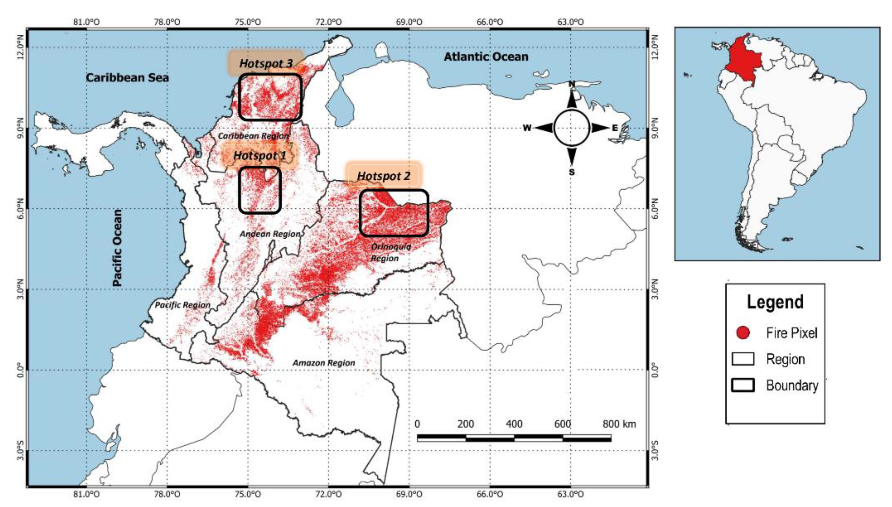
2.1. Study Area

The study area is represented in Figure 1 and shows Colombia, a country located in the tropic zone at north of South America at 12°26′46 North, 4°13′30 South, 66°50′54 East, and 79°02′33 West. Colombia has a surface of 1141748 km2, to which are added the marine and underwater platforms, as well as the coasts on the Pacific and Atlantic oceans. The climatic and landscape diversity is determined for the five natural regions, namely: the Andean region, made up of three divisions of the Andes Mountains; the Amazon region, considered the lung of the planet due to the huge forest area; the Caribbean region, located on the north coast of Colombia; the Orinoquia region, with huge plains and grass areas; and the Pacific region, which has exuberant vegetation and high humidity [32].
The annual cycle of rains in Colombia obeys three types of regimes: unimodal (a wet season and a dry season), bimodal (two wet seasons and two dry), and mixed (a combination of both). In general, the unimodal regime prevails over the bimodal and the mixed. The unimodal regime occurs in the south and center of the Caribbean region and in the north of the Andean region, in the Orinoco and Amazon regions, and in the north of the Pacific region. The bimodal and mixed regimes occur mainly in the Andean region and the north of the Caribbean region, in La Guajira. The Pacific region observes the occurrence of the four-rainfall regime [33].

2.2. Data and Sources

Data from 21 years (2000–2020) of thermal anomalies, detected by the Moderate-Resolution Imaging Spectroradiometer (MODIS) sensor, by The Fire Information for Resource Management System (FIRMS-NASA) (https://firms.modaps.eosdis.nasa.gov/) (accessed on 11 November 2021), were used. In other works, such as the one carried out by Chuvieco et al., 2005 [34] on the evaluation of NOAA-AVHRR and TERRA-MODIS images for the regional cartography of burned areas, the benefits of this second sensor have been identified, since it offers better spatial resolution and bands better adapted to the radiometric characteristics of recently burned areas, especially those in the SWIR region. In the case of MODIS, the confusion between burned areas and water can be resolved through synthetic spectral index. In addition, MODIS images were pre-processed by NASA, including geo-referencing, conversion to reflectivity values, and multi-temporal composites.
Specifically, we used the Terra and Aqua satellites; this data was based on the MCD14ML series, and the minimum size (resolution) of the data was 1 km. With this information, a density surface was constructed to identify the areas that presented the highest number of fire events in Colombia for the period analyzed. The MODIS data that were used have a confidence value ranging from 0% (lowest confidence) to 100% (highest confidence) [35]. Fire detections with confidence values ≥ 80% (high confidence class) were selected in order to minimize the number of false alarms [36,37,38]. Then, a density surface was constructed to identify the areas that presented the highest number of fire events per unit area. MODIS fire products have had to improve their algorithms to overcome the limitations of this product, which include lack of fire detection due to cloud cover, dense smoke, and dense tree canopies, the occurrence of fires between satellite overflights, and fires that are too small or too cold [8,39,40,41]. These drawbacks were improved with Collection 6 [35]. The number of daily hotspots is used to identify fire-periods and the important dates of major hotspot peaks during the fire-periods. The regional dataset of monthly average temperature (°C) was obtained from the Climate Engine open access service (http://climateengine.org/) (accessed on 7 November 2021).
For the treatment of the geographic data, QGIS 3.0 software was used to process data. Analysis of the burned areas in each region, through the period of 2000–2020, was also carried out using this software. The fire data were downloaded in text format, each file providing information about the location (longitude, latitude), date, confidence level of the estimate, and satellite that detected each fire. Based on the numerical size of fire density, fire-prone regions were identified. A ‘fire-prone’ region is defined as a region with above-average fires over the study period.
Spearman’s rank correlation tests (due to the lack of normality of fires and climatic data) were used to examine the correlation between fire density and the variables temperature and precipitation in the five natural regions [21].

3. Results and Discussion

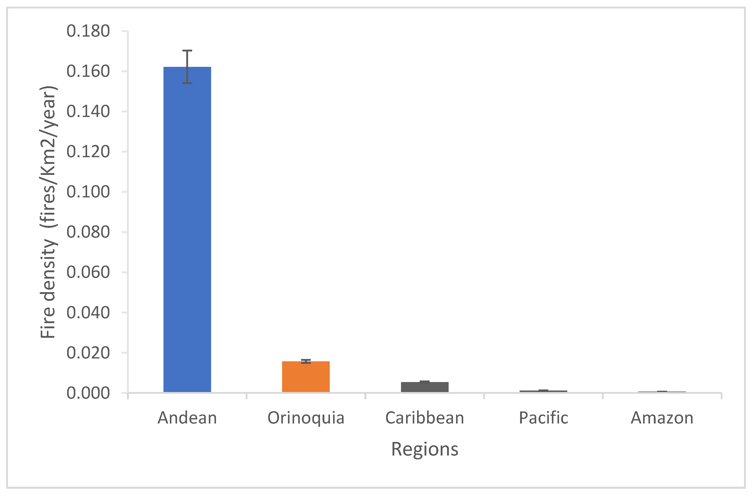
3.1. Colombia’s Regions and Their Relationship with Fire

The relationship between ecosystems and fire varies depending on the type of ecosystem, all ecosystems not being related equally to fire. This relationship varies in terms of natural fire regimes, and, based on this, they can be classified into fire-sensitive, fire-dependent, and fire-independent ecosystems [42]. The most affected biomes in Colombia are the savannahs, grasslands, and tropical shrubs, followed by tropical humid forests [17,21]. In the Orinoquia region, crops are the main driver of forest loss, while in the Amazon region, deforestation is mainly due to fires related to the colonization front [43].
Colombia’s regions also differ in climate; indeed, the Orinoquia and Caribbean regions are relatively dry (rainfall in the dry season < 50 mm per month). The Orinoquia region is a sparsely populated, relatively flat region dominated by grasslands and pastures, with some areas of small-scale agriculture and considerable gallery forest associated with its extensive river network. The Caribbean region, is highly transformed, dominated by grasslands with few remnants of natural vegetation, and only a few patches of dry forest. On the other hand, the Amazon region is more humid, with an annual rainfall greater than 2000 mm/year, whereas the Pacific region comprises an extremely humid area (rainfall greater than 10000 mm/year) in the western part of the country [21]. In addition, the Amazon region has high and permanent rainfall, little variability in temperature, and a relative humidity always very close to the saturation point. This region contains the largest extension of forest in Colombia, and, although it is sparsely populated, it has one of the most active colonization fronts in the country. The Pacific region has a humid to super-humid tropical climate, and is considered one of the wettest regions in the world, with annual rainfall ranging from 4000 mm to more than 10000 mm in some places. This region is also sparsely populated, and is recognized worldwide as one of the most biologically and culturally diverse areas in the world, containing indigenous and Afro-American reserves [21].

3.2. Active Fires Spatial Distribution

Over the study period (2000–2020) there were 555,919 active fire occurrences with a confidence level above 80%. The annual distribution analysis of the thermal anomalies dataset was not homogeneous (Figure 2); the year 2004 registered the highest number of fires (45,640 fires), representing 8.21%, followed by 2007 with 44,672 fires (8.04%) and 2003 with 38,882 fires (6.99%). The year 2000 was the least active, with only 12496 fires (2.25%), followed by 2001 (2.49%). Further, great variability between regions was found. Fires were more abundant in the East (Orinoquia region) than the South (Amazon region), especially in the dry season; this result agrees with other studies [21]. The Orinoquia region recorded the highest concentration of hotspots (83,409 ± 185 fires) visible on the fire map (Figure 1); in this region, fires were strongly associated with the expansion of the agricultural and livestock frontier, due to changes in land use [44,45], followed by the Caribbean region (15,081 ± 60 fires). Fewer hotspots were observed in the Andean region, with 5528 ± 16 fires, as well as the Pacific (3313 ± 9 fires) and Amazon regions (5382 ± 252 fires). Over the 21 years, the total number of MODIS active fires was 112,713 ± 71. These results corroborate what was stated in the study carried out by Viviana Cecilia Chivatá López in 2017 [46], which concluded that the most-affected plant covers correspond to savannahs, grasslands and pastures, stubble, crops, dense natural forest, and xerophytic vegetation, characteristic of the Orinoquia region and some areas of the Caribbean and Andean regions.
In general, fires in Colombia increase during the dry season, with the Orinoquia and Caribbean regions being the most affected. In addition, for the most part, fires in the Orinoquia region are mainly induced as a traditional cultural practice to improve the quality of pastures for livestock and expand the agricultural frontier [47], while in the Caribbean region fires are the result of complex interactions between regional and local biophysical and anthropogenic factors, more related to local climatic processes linked to the variability of both intra-annual and inter-annual rainfall [20].

3.3. Fire Density Variations

The average fire density in Colombia was 3.2 × 10⁻⁵ ± 1.77 × 10⁻⁵ fires km−2 year−1. However, many variations were observed by region. When ranked in descending order using the 21-year data set (Figure 3), the Amazon region, located in the south, had the lowest fire density (average of 0.001 ± 0.001 fires km−2 year−1), while the central Andean region registered the highest fire density (0.162 ± 0.086 fires km−2 year−1). Based on comparison to the national average, among the five natural regions of the country, only three (Andean, Orinoquia, and Caribbean) were identified as being prone to fire.
Based on the previous identification of the fire-prone regions, and taking into account the density of the fires, shown in Figure 4, it is possible to consider the grouping of these in three main fire foci as contiguous areas of high risk. The critical fire points are located in the regions with the highest fire density, identifying the areas that were most affected [48]. These three major fire hotspots were designated (from highest to lowest fire density) as: Central, East, and West Hotspots. Hotspot 1 is located in the Andean region, east of its great savannahs; Hotspot 2 is made up of the Orinoquia region; and Hotspot 3 is located in the Caribbean region (Figure 1).

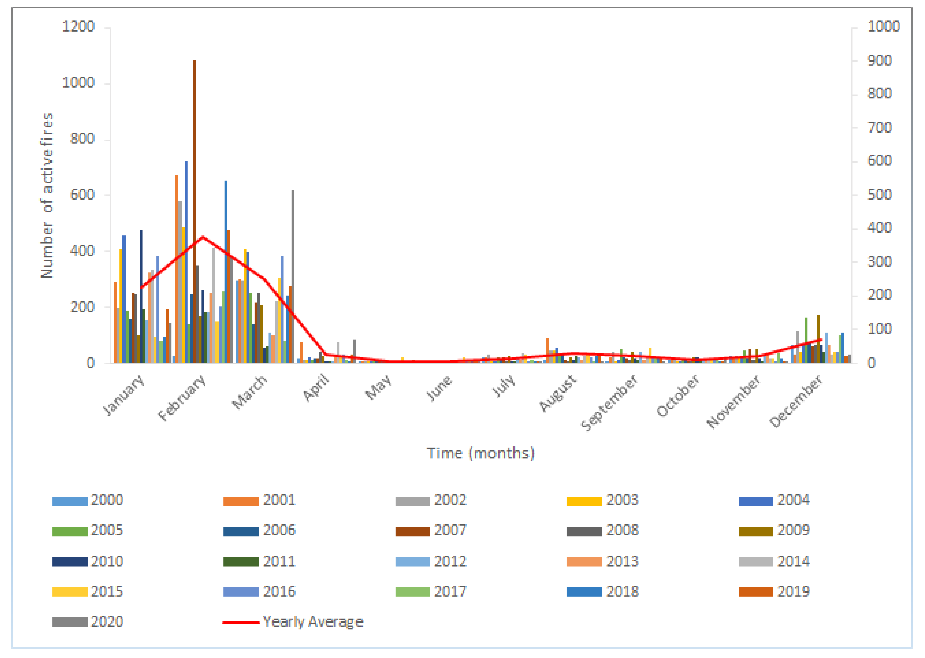
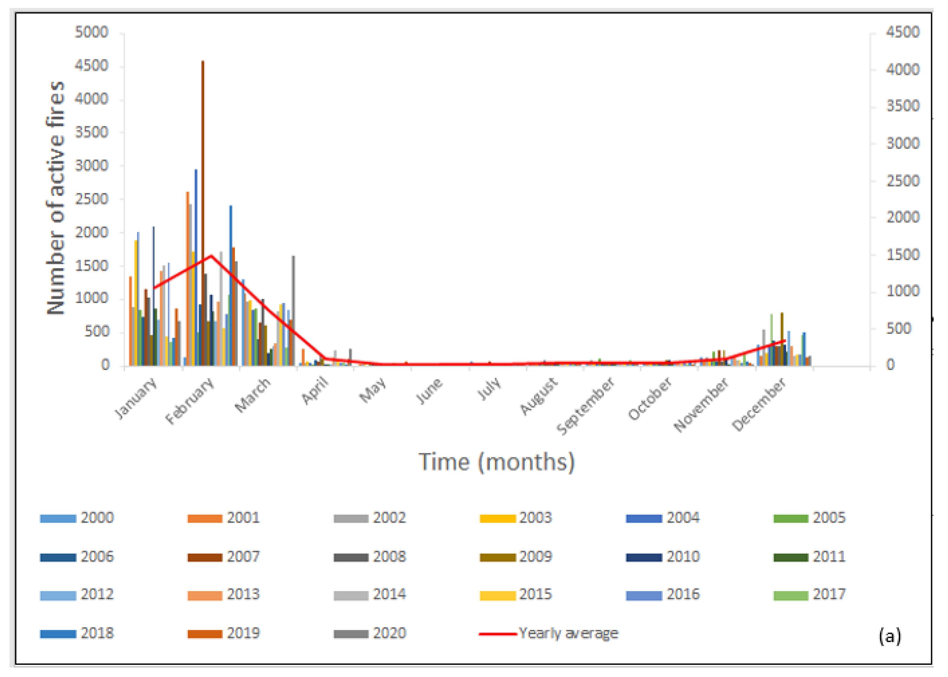
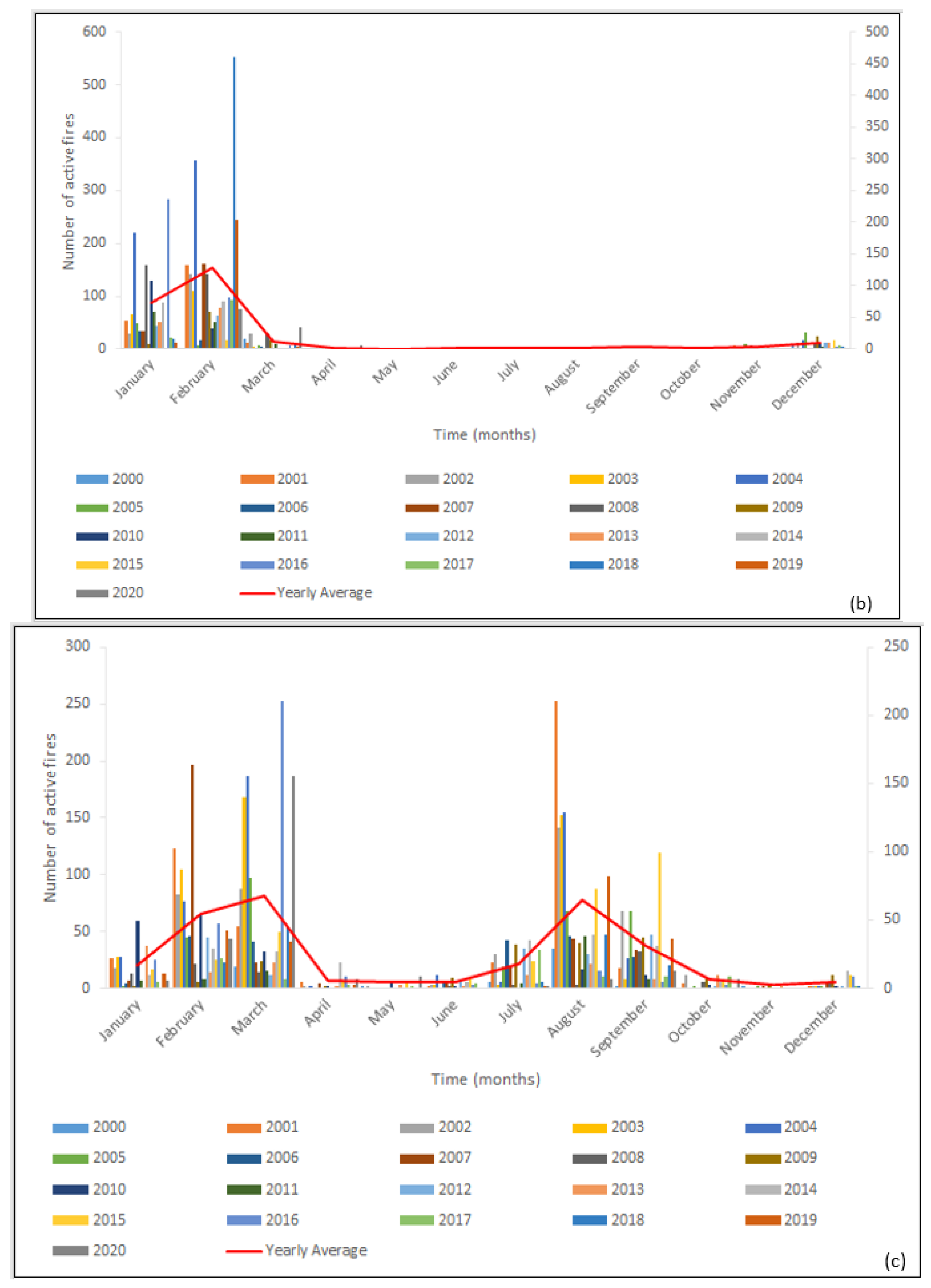
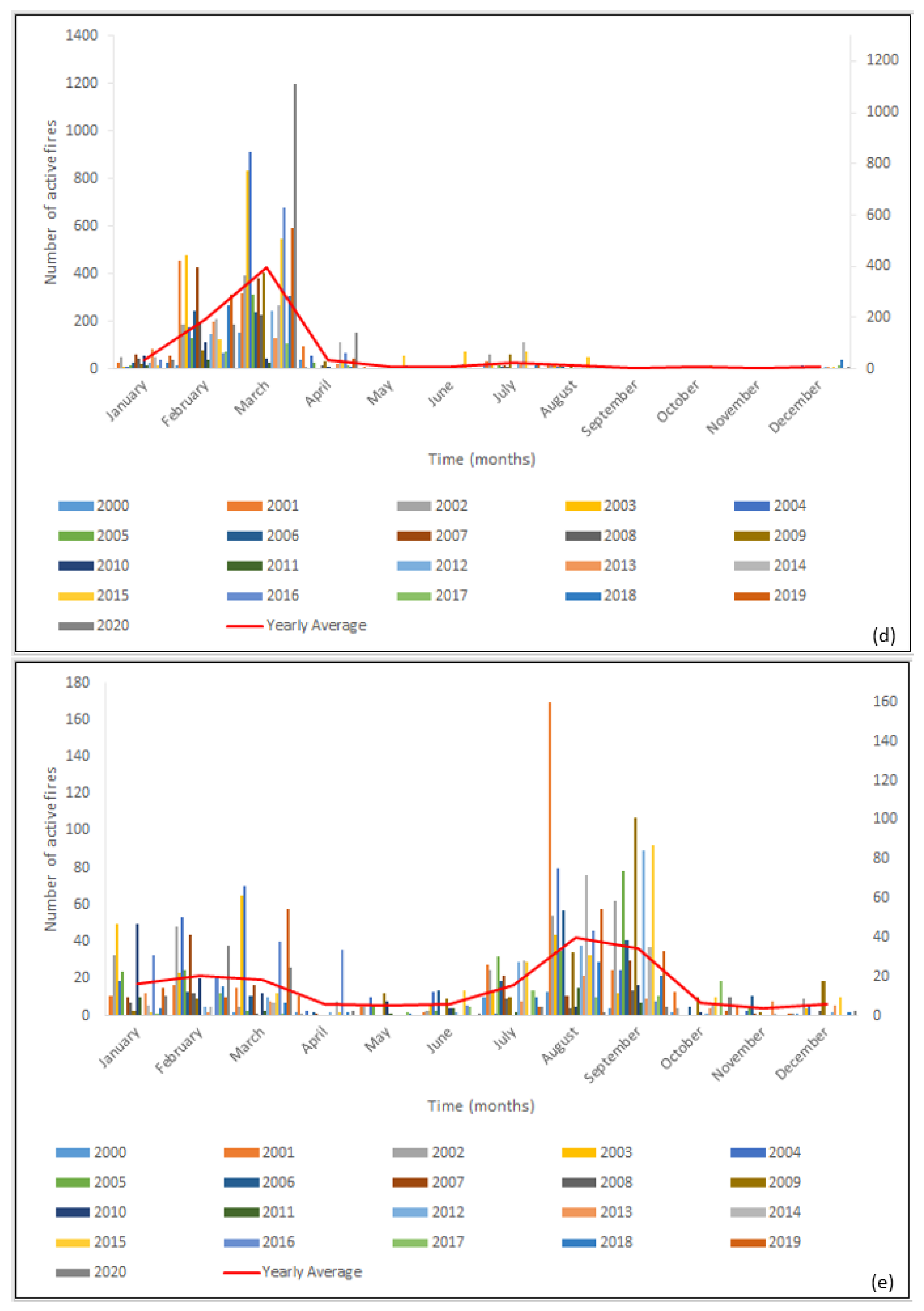
3.4. Fire Seasonality of the Regions over the Period 2000–2020

Fire peaks occur during the dry season, normally between December–March, in the Orinoquia, Amazon, and Caribbean regions, while in the Pacific and Andean regions fire peaks are observed both in the months of December–March and between August and September. During the months of December–March, around 71% of the occurrence of fires in the country was recorded (Figure 5), a period that corresponds to the dry season in most regions [49]; the lowest fire occurrence was registered in October [50]. Furthermore, the highest incidence of thermal anomalies occurred in the Orinoquia region [21,51].
In the Andean and Pacific regions there are two annual fire peaks, similar to those evidenced in a study of fires in South Africa [52], but in contrast to a study carried out in the Ivory Coast, in which a fire peak was recorded of single fires [48], as observed in the Orinoquia, Caribbean, and Amazon regions (Figure 6).

3.5. Relation between Fire Density and Temperature in the Main Fire Hotspots

The correlation between fire density and temperature showed the presence of a positive correlation, yielding a significant correlation between these variables for the Andean (Rho = 0.7506, p = <0.0001), Pacific (Rho = 0.7364, p = <0.0001), and Caribbean (Rho = 0.5571, p = <0.0087) regions (Table 1). The presence of autocorrelation between fire density and temperature was explored by calculating a Spearman’s Rho correlation using annual data from the studied regions. In other words, an increase in temperature may be one of the aspects of fire generation in these regions.
Some targets for future works could be fire severity assessment by means of multi-temporal comparison between pre- and post-fire satellite images using the differenced Normalized Burn Ratio (dNBR) spectral index, fire severity being an essential analysis for the establishment of post-fire effects. In addition, the analysis of other variables as drivers of fire is suggested.

4. Conclusions

This research shows the dynamics of fires in Colombia during the last two decades, identifying high-risk regions and fire seasons. Three fire-prone regions were identified in eastern, central, and northern Colombia, the savannah areas having a higher incidence of fires. Most fires occur in the dry season (December–March). However, the period of fire occurrence and fire peaks changes slightly according to region.
This study showed that 2004 and 2000 recorded the highest and lowest number of fires in Colombia, respectively. Although most fires occur in the Orinoquia region, when calculating fires by area density it was found that the most affected region was the Andean region. The Orinoquia region has approximately twice the size of the Andean region, but considering that the savanna ecosystem predominates in the Orinoquia region, which is prone to fire, there was a greater occurrence of fires. However, only the Andean, Pacific, and Caribbean regions showed a significant positive correlation between temperature and number of hotspots.
It is hoped that this study will help improve fire forecast abilities in Colombia, and lead to mitigation against climate change by reducing active fires.

Author Contributions

Conceptualization, S.B.-D., Y.C.-C. and T.R.B.-O.; formal analysis, S.B.-D. and T.R.B.-O.; methodology, S.B.-D., Y.C.-C. and T.R.B.-O.; supervision, Y.C.-C.; writing—original draft, S.B.-D.; writing—review and editing, S.B.-D., T.D.S., A.B.N. and T.R.B.-O. All authors have read and agreed to the published version of the manuscript.

Funding

This research was funded by the Universidad del Magdalena, Santa Marta, Colombia.

Data Availability Statement

The data used in this study are available to individuals upon request.

Conflicts of Interest

The authors declare no conflict of interest.

References

  1. Masís, R.; Lizano, M. Análisis espacio-temporal de áreas quemadas en la región chorotega, costa rica entre 2001 y 2015. J. Chem. Inf. Model. 2019, 53, 1689–1699. [Google Scholar] [CrossRef]
  2. N’Dri, A.B.; Kone, A.W.; Loukou, S.K.K.; Barot, S.; Gignoux, J. Carbon and nutrient losses through biomass burning, and links with soil fertility and yam (dioscorea alata) production. Exp. Agric. 2019, 55, 738–751. [Google Scholar] [CrossRef]
  3. Vernooij, R.; Alves, M.V.G.; Borges, M.A.; Costa, M.M.; Barradas, A.C.S.; van der Werf, G. Seasonality of Greenhouse Gas Emission Factors from Biomass Burning in the Brazilian Cerrado. Biogeosci. Discuss. 2020, 1–32. [Google Scholar] [CrossRef]
  4. Adab, H.; Kanniah, K.D.; Solaimani, K. Modeling Forest Fire Risk in the Northeast of Iran Using Remote Sensing and GIS Techniques. Nat. Hazards 2013, 65, 1723–1743. [Google Scholar] [CrossRef]
  5. Stefanidis, S.; Alexandridis, V.; Spalevic, V.; Mincato, R.M. Wildfire Effects on Soil Erosion Dynamics: The Case of 2021 Megafires In Greece. Agric. For. 2022, 68, 15. [Google Scholar] [CrossRef]
  6. Efthimiou, N.; Psomiadis, E.; Panagos, P. Fire Severity and Soil Erosion Susceptibility Mapping Using Multi-Temporal Earth Observation Data: The Case of Mati Fatal Wildfire in Eastern Attica, Greece. CATENA 2020, 187, 104320. [Google Scholar] [CrossRef]
  7. Esposito, G.; Parodi, A.; Lagasio, M.; Masi, R.; Nanni, G.; Russo, F.; Alfano, S.; Giannatiempo, G. Characterizing Consecutive Flooding Events after the 2017 Mt. Salto Wildfires (Southern Italy): Hazard and Emergency Management Implications. Water 2019, 11, 2663. [Google Scholar] [CrossRef]
  8. Van der Werf, G.R.; Randerson, J.T.; Collatz, G.J.; Giglio, L. Carbon Emissions from Fires in Tropical and Subtropical Ecosystems. Glob. Change Biol. 2003, 9, 547–562. [Google Scholar] [CrossRef]
  9. Langenfelds, R.L.; Francey, R.J.; Pak, B.C.; Steele, L.P.; Lloyd, J.; Trudinger, C.M.; Allison, C.E. Interannual Growth Rate Variations of Atmospheric CO2 and Its Δ13C, H2, CH4, and CO between 1992 and 1999 Linked to Biomass Burning. Glob. Biogeochem. Cycles 2002, 16, 21-1–21-22. [Google Scholar] [CrossRef]
  10. Shi, G.; Yan, H.; Zhang, W.; Dodson, J.; Heijnis, H.; Burrows, M. Rapid Warming Has Resulted in More Wildfires in Northeastern Australia. Sci. Total Environ. 2021, 771, 144888. [Google Scholar] [CrossRef]
  11. Loiselle, D.; Du, X.; Alessi, D.S.; Bladon, K.D.; Faramarzi, M. Projecting Impacts of Wildfire and Climate Change on Streamflow, Sediment, and Organic Carbon Yields in a Forested Watershed. J. Hydrol. 2020, 590, 125403. [Google Scholar] [CrossRef]
  12. Abdollahi, M.; Islam, T.; Gupta, A.; Hassan, Q.K. An Advanced Forest Fire Danger Forecasting System: Integration of Remote Sensing and Historical Sources of Ignition Data. Remote Sens. 2018, 10, 923. [Google Scholar] [CrossRef]
  13. Rodríguez-Trejo, D.A.; Fulé, P.Z. Fire Ecology of Mexican Pines and a Fire Management Proposal. Int. J. Wildland Fire 2003, 12, 23–37. [Google Scholar] [CrossRef]
  14. Castillo, M.E.S.; Garfias, R.S.; Julio, G.A.; Gonzalez, L.R. Nativa De Chile. Red Rev. Científicas América Lat. el Caribe España y Port. 2012, 37, 796–804. [Google Scholar]
  15. San-Miguel-Ayanz, J.; Schulte, E.; Schmuck, G.; Camia, A.; Strobl, P.; Liberta, G.; Giovando, C.; Boca, R.; Sedano, F.; Kempeneers, P.; et al. Comprehensive Monitoring of Wildfires in Europe: The European Forest Fire Information System (EFFIS). In Approaches to Managing Disaster—Assessing Hazards, Emergencies and Disaster Impacts; IntechOpen: London, UK, 2012; pp. 87–109. ISBN 978-953-51-0294-6. [Google Scholar]
  16. Cizungu, N.C.; Tshibasu, E.; Lutete, E.; Mushagalusa, C.A.; Mugumaarhahama, Y.; Ganza, D.; Karume, K.; Michel, B.; Lumbuenamo, R.; Bogaert, J. Fire Risk Assessment, Spatiotemporal Clustering and Hotspot Analysis in the Luki Biosphere Reserve Region, Western DR Congo. Trees For. People 2021, 5, 100104. [Google Scholar] [CrossRef]
  17. Armenteras, D. Incendios En Ecosistemas Del Norte de Suramérica: Avances En La Ecología Del Fuego Tropical En Colombia, Ecuador y Perú Fire in the Ecosystems of Northern South America: Advances in the Ecology of Tropical. Caldasia 2020, 42, 1–16. [Google Scholar] [CrossRef]
  18. Munawar, H.S.; Ullah, F.; Khan, S.I.; Qadir, Z.; Qayyum, S. UAV Assisted Spatiotemporal Analysis and Management of Bushfires: A Case Study of the 2020 Victorian Bushfires. Fire 2021, 4, 40. [Google Scholar] [CrossRef]
  19. de Oliveira-Júnior, J.F.; Mendes, D.; Filho, W.L.F.C.; Junior, C.A.D.S.; de Gois, G.; Jardim, A.M.D.R.F.; da Silva, M.V.; Lyra, G.B.; Teodoro, P.E.; Pimentel, L.C.G.; et al. Fire Foci in South America: Impact and Causes, Fire Hazard and Future Scenarios. J. S. Am. Earth Sci. 2021, 112, 103623. [Google Scholar] [CrossRef]
  20. Hoyos, N.; Correa-Metrio, A.; Sisa, A.; Ramos-Fabiel, M.A.; Espinosa, J.M.; Restrepo, J.C.; Escobar, J. The Environmental Envelope of Fires in the Colombian Caribbean. Appl. Geogr. 2017, 84, 42–54. [Google Scholar] [CrossRef]
  21. Armenteras-Pascual, D.; Retana-Alumbreros, J.; Molowny-Horas, R.; Roman-Cuesta, R.M.; Gonzalez-Alonso, F.; Morales-Rivas, M. Characterising Fire Spatial Pattern Interactions with Climate and Vegetation in Colombia. Agric. For. Meteorol. 2011, 151, 279–289. [Google Scholar] [CrossRef]
  22. Armenteras, D.; Gonzalez-Alonso, F.; Franco Aguilera, C. Geographic and Temporal Distribution of Fire in Colombia Using Thermal Anomalies Data. Caldasia 2009, 31, 303–318. Available online: http://www.scielo.org.co/scielo.php?script=sci_arttext&pid=S0366-52322009000200007&lng=en&nrm=iso (accessed on 4 September 2021).
  23. Zúñiga-Vásquez, J.M.; Cisneros-González, D.; Pompa-García, M.; Rodríguez-Trejo, D.A.; Pérez-Verdín, G. Spatial Modeling of Forest Fires in Mexico: An Integration of Two Data Sources. Bosque 2017, 38, 563–574. [Google Scholar] [CrossRef]
  24. Csiszar, I.A.; Morisette, J.T.; Giglio, L. Validation of Active Fire Detection from Moderate-Resolution Satellite Sensors: The MODIS Example in Northern Eurasia. IEEE Trans. Geosci. Remote Sens. 2006, 44, 1757–1764. [Google Scholar] [CrossRef]
  25. Armenteras, D.; Gibbes, C.; Vivacqua, C.A.; Espinosa, J.S.; Duleba, W.; Goncalves, F.; Castro, C. Interactions between Climate, Land Use and Vegetation Fire Occurrences in El Salvador. Atmosphere 2016, 7, 26. [Google Scholar] [CrossRef]
  26. Hantson, S.; Padilla, M.; Corti, D.; Chuvieco, E. Strengths and Weaknesses of MODIS Hotspots to Characterize Global Fire Occurrence. Remote Sens. Environ. 2013, 131, 152–159. [Google Scholar] [CrossRef]
  27. Bajocco, S.; Koutsias, N.; Ricotta, C. Linking Fire Ignitions Hotspots and Fuel Phenology: The Importance of Being Seasonal. Ecol. Indic. 2017, 82, 433–440. [Google Scholar] [CrossRef]
  28. Gonzalez-Olabarria, J.R.; Brotons, L.; Gritten, D.; Tudela, A.; Teres, J.A. Identifying Location and Causality of Fire Ignition Hotspots in a Mediterranean Region. Int. J. Wildland Fire 2012, 21, 905–914. [Google Scholar] [CrossRef]
  29. Koutsias, N.; Allgöwer, B.; Kalabokidis, K.; Mallinis, G.; Balatsos, P.; Goldammer, J.G. Fire Occurrence Zoning from Local to Global Scale in the European Mediterranean Basin: Implications for Multi-Scale Fire Management and Policy. IForest 2016, 9, 195–204. [Google Scholar] [CrossRef]
  30. Hayasaka, H.; Yamazaki, K.; Naito, D. Weather Conditions and Warm Air Masses during Active Fire-Periods in Boreal Forests. Polar Sci. 2019, 22, 100472. [Google Scholar] [CrossRef]
  31. Carmel, Y.; Paz, S.; Jahashan, F.; Shoshany, M. Assessing Fire Risk Using Monte Carlo Simulations of Fire Spread. For. Ecol. Manag. 2009, 257, 370–377. [Google Scholar] [CrossRef]
  32. PNUD PNUD Colombia. Available online: https://www.co.undp.org/content/colombia/es/home/countryinfo.html (accessed on 3 December 2021).
  33. Urrea, V.; Ochoa, A.; Mesa, O. Seasonality of Rainfall in Colombia. Water Resour. Res. 2019, 55, 4149–4162. [Google Scholar] [CrossRef]
  34. Chuvieco, E.; Ventura, G.; Martín, M.P.; Gómez, I. Assessment of Multitemporal Compositing Techniques of MODIS and AVHRR Images for Burned Land Mapping. Remote Sens. Environ. 2005, 94, 450–462. [Google Scholar] [CrossRef]
  35. Giglio, L.; Schroeder, W.; Justice, C.O. The Collection 6 MODIS Active Fire Detection Algorithm and Fire Products. Remote Sens. Environ. 2016, 178, 31–41. [Google Scholar] [CrossRef] [PubMed]
  36. Fusco, E.J.; Finn, J.T.; Abatzoglou, J.T.; Balch, J.K.; Dadashi, S.; Bradley, B.A. Detection Rates and Biases of Fire Observations from MODIS and Agency Reports in the Conterminous United States. Remote Sens. Environ. 2019, 220, 30–40. [Google Scholar] [CrossRef]
  37. Hawbaker, T.J.; Radeloff, V.C.; Syphard, A.D.; Zhu, Z.; Stewart, S.I. Detection Rates of the MODIS Active Fire Product in the United States. Remote Sens. Environ. 2008, 112, 2656–2664. [Google Scholar] [CrossRef]
  38. Peterson, D.; Wang, J.; Ichoku, C.; Hyer, E.; Ambrosia, V. A Sub-Pixel-Based Calculation of Fire Radiative Power from MODIS Observations: 1: Algorithm Development and Initial Assessment. Remote Sens. Environ. 2013, 129, 262–279. [Google Scholar] [CrossRef]
  39. Wang, W.; Qu, J.J.; Hao, X.; Liu, Y. Analysis of the Moderate Resolution Imaging Spectroradiometer Contextual Algorithm for Small Fire Detection. Appl. Remote Sens. 2009, 3, 031502. [Google Scholar] [CrossRef]
  40. Wang, W.; Qu, J.J.; Hao, X.; Liu, Y.; Sommers, W.T. An Improved Algorithm for Small and Cool Fire Detection Using MODIS Data: A Preliminary Study in the Southeastern United States. Remote Sens. Environ. 2007, 108, 163–170. [Google Scholar] [CrossRef]
  41. Schroeder, W.; Prins, E.; Giglio, L.; Csiszar, I.; Schmidt, C.; Morisette, J.; Morton, D. Validation of GOES and MODIS Active Fire Detection Products Using ASTER and ETM+ Data. Remote Sens. Environ. 2008, 112, 2711–2726. [Google Scholar] [CrossRef]
  42. Hardesty, J.; Myers, R.; Fulks, F. Fire, Ecosystems and People: A Preliminary Assessment of Fire as a Global Conservation Issue; George Wright Society: Hancock, MI, USA, 2005. [Google Scholar]
  43. Armenteras, D.; Cabrera, E.; Rodrı, N. National and Regional Determinants of Tropical Deforestation in Colombia. Reg. Environ. Chang. 2013, 13, 1181–1193. [Google Scholar] [CrossRef]
  44. Fontanilla-Díaz, C.A.; Preckel, P.V.; Lowenberg-DeBoer, J.; Sanders, J.; Peña-Lévano, L.M. Identifying Profitable Activities on the Frontier: The Altillanura of Colombia. Agric. Syst. 2021, 192, 103199. [Google Scholar] [CrossRef]
  45. Chivatá López, V. Análisis Espacial Comparativo de Los Focos de Calor Con Las Coberturas de La Tierra Corine Land Cover y El Ráster de Susceptibilidad a Incendios de La Cobertura Vegetal; Universidad Militar Nueva Granada: Bogotá, Colombia, 2017. [Google Scholar]
  46. Chivata Lopéz, V. Comparative Spatial Analysis of the Heat Points with the Land Coverings and the Raster of Susceptibility to the Forest; 2017. Available online: https://repository.unimilitar.edu.co/handle/10654/16446 (accessed on 3 December 2021).
  47. Sánchez Ojeda, F.; Armenteras Pascual, D.; Sánchez Ojeda, F.; Armenteras Pascual, D. Changes in Soil Organic Carbon after Burning in a Forest-Savanna Edge. Acta Agronómica 2017, 66, 519–524. [Google Scholar] [CrossRef]
  48. Soro, T.D.; Koné, M.; N’Dri, A.B.; N’Datchoh, E.T. Identified Main Fire Hotspots and Seasons in Côte d’Ivoire (West Africa) Using MODIS Fire Data. S. Afr. J. Sci. 2021, 117, 1–13. [Google Scholar] [CrossRef]
  49. IDEAM. Boletín Informativo Sobre El Monitoreo de Los Fenómenos de Variabilidad Climática “El Niño” y “La Niña”; IDEAM: Bogota, Colombia, 2017.
  50. Poveda, G.; Waylen, P.R.; Pulwarty, R.S. Annual and Inter-Annual Variability of the Present Climate in Northern South America and Southern Mesoamerica. Palaeogeogr. Palaeoclimatol. Palaeoecol. 2006, 234, 3–27. [Google Scholar] [CrossRef]
  51. Huesca, M.; Gonzáles, A.; Cuevas, M. Distribución Espacial Y Temporal De Los Incendios Forestales En España Utilizando Datos De Anomalías Térmicas; 2009; pp. 309–3012. Available online: https://ris.utwente.nl/ws/files/267089960/DISTRIBUCION_ESPACIAL_Y_TEMPORAL_DE_LOS_INCENDIOS_.pdf (accessed on 3 December 2021).
  52. Strydom, S.; Savage, M.J. A Spatio-Temporal Analysis of Fires in South Africa. S. Afr. J. Sci. 2016, 112, 1–8. [Google Scholar] [CrossRef] [Green Version]
Figure 1. Map of the spatial distribution of active fires in Colombia, showing main fire hotspots.
Fire 05 00134 g001
Figure 2. Annual distribution of fires (%) in Colombia from 2000 to 2022. The highest peak can be observed in 2004, followed by 2003 and 2007, respectively.
Fire 05 00134 g002
Figure 3. Average fire density per year in natural regions of Colombia over a 21-year period (2000 to 2020).
Fire 05 00134 g003
Figure 4. Average number of active fires per year in natural regions of Colombia over a 21-year period (2000 to 2020).
Fire 05 00134 g004
Figure 5. Temporal distribution of active fires in Colombia, by month, from 2000 to 2020.
Fire 05 00134 g005
Figure 6. Temporal distribution of fire occurrence by month in Colombia regions: (a) Orinoquia; (b) Amazon; (c) Andean; (d) Caribbean; (e) Pacific.
Fire 05 00134 g006aFire 05 00134 g006bFire 05 00134 g006c
Table 1. Spearman correlation (Cs) between fire density and temperature in the main fire hotspots.
Regions
AmazonAndeanCaribbeanOrinoquiaPacific
CsCsCsCsCs
0.11170.7506 *0.5571 *0.34290.7364 *
* In bold, significant values are p < 0.010.
Publisher’s Note: MDPI stays neutral with regard to jurisdictional claims in published maps and institutional affiliations.

