Article

Assessing the Role of Forest Grazing in Reducing Fire Severity: A Mitigation Strategy

by
Raffaella Lovreglio
1,*,
Julian Lovreglio
2,
Gabriele Giuseppe Antonio Satta
1,
Marco Mura
1 and
Antonio Pulina
1
1
Department of Agriculture, University of Sassari, Viale Italia, 07100 Sassari, Italy
2
Department of Soil, Plant and Food Sciences (DISSPA), University of Bari (UNIBA), Via Amendola 165/A, 70126 Bari, Italy
*
Author to whom correspondence should be addressed.
Fire 2024, 7(11), 409; https://doi.org/10.3390/fire7110409
Submission received: 8 October 2024 / Revised: 4 November 2024 / Accepted: 5 November 2024 / Published: 8 November 2024
(This article belongs to the Special Issue Effects of Fires on Forest Ecosystems)

Abstract

:
This study investigates the role of prescribed grazing as a sustainable fire prevention strategy in Mediterranean ecosystems, with a focus on Sardinia, an area highly susceptible to wildfires. Using FlamMap simulation software, we modeled fire behavior across various grazing and environmental conditions to assess the impact of grazing on fire severity indicators such as flame length, rate of spread, and fireline intensity. Results demonstrate that grazing can reduce fire severity by decreasing combustible biomass, achieving reductions of 25.9% in fire extent in wet years, 60.9% in median years, and 45.8% in dry years. Grazed areas exhibited significantly lower fire intensity, particularly under high canopy cover. These findings support the integration of grazing into fire management policies, highlighting its efficacy as a nature-based solution. However, the study’s scope is limited to small biomass fuels (1-h fuels); future research should extend to larger fuel classes to enhance the generalizability of prescribed grazing as a fire mitigation tool.

1. Introduction

Climate change heavily influences anthropogenic disasters such as wildfires, and consequential prevention measures are of increasing international concern (Rovithakis et al., 2022) [1]. The 2021 fire season was the second worst in EU recorded history, as more than 550,000 hectares of land burned (San-Miguel-Ayanz et al., 2022) [2], with ramifications being felt in natural world (e.g., loss of habitat, biodiversity, native vegetation (e.g., expansion of invasive species)) and in terms of human livelihood, property, and health (IPBES, 2019) [3]. The following year, 2022, fared much worse, with over 16,941 fires burning 1,624,381 hectares (ha), about the size of Montenegro, across the 45 EU countries (Simpson C., 2024) [4].
The 2023 fire season shattered records, as it was among the longest and fiercest in history and represented an incredible 86% increase compared to 2021 (Silva, 2023) [5]. Mediterranean ecosystems are fire-prone, leading to severe environmental and socio-economic consequences when it comes to wildfires (Turco et al., 2018) [6]. The escalation in both the frequency and intensity of these extreme events is further intensified by the transition from traditional small-scale farming practices to modern, intensely managed farms, as well as the overarching trend of homogenization in Mediterranean landscapes through extensive plantations and monocultural production (Rouet-Leduc et al., 2021) [7]. These land use changes contribute to an increase in fuel load, i.e., higher fire hazard, and must be taken into consideration when discussing land management strategies and efforts to mitigate wildfire risks (Moreira et al., 2020) [8]. The management of grazed forest pastures is considered one of the cheapest and most effective tools for reducing combustible biomass for the prevention of summer fires in the Mediterranean environment (Ascoli et al., 2023; [9] Oikonomou et al., 2023 [10]). Numerous studies have consistently found that herbivorous grazing plays a crucial role in mitigating fire intensity and/or severity through reductions in fuel load and vegetation height, as animals trample and consume plant biomass (Rouet-Leduc et al., 2021, [7] Ribeiro et al., 2023, [11] Smit & Coetsee, 2019 [12]). Both domestic and wild grazing herbivores have fuel reduction capacities, depending on a number of variables such as the pastoralism regime, feeding behaviors, rotational grazing, species introduction, seasonal variation, and the amount/type of ground vegetal cover present (Rouet-Leduc et al., 2021, Allen et al., 2011) [7,13]. Specific management strategies must be analyzed in order to discern the applicability and generalizability of using grazing to reduce fuel loads and mitigate wildfire risks. In Rouet-Leduc et al. (2021) [7], 74 studies were reviewed, 21 of which directly evaluated the effects of herbivores on fire frequency. Other studies found that grazing reduces the frequency of fires only in some cases, depending on the time of year, the management associated with grazing (Vacchiano et al., 2018) [14], or the type of vegetation (Starns et al., 2019) [15]. In some cases, the presence of herbivores creates conditions for more frequent but less intense fires, thus reducing the frequency of extreme fires (Ngugi et al., 2022) [16]. Although herbivore grazing can maintain mostly grassy ecosystems that favor low-intensity fires and reduce their frequency (Kramer et al., 2003) [17], intensive grazing can have the opposite effect by reducing grass cover (Pausas & Keeley, 2014) [18] and favoring the recruitment of highly flammable woody non-palatable vegetation (Bachelet et al., 2000) [19].
Several studies have proposed prescribed grazing as a nature-based solution (NBS) for wildfire risk management (Wagner et al., 2023; [20] Li et al. 2023 [21]). Nature-based solutions can be defined as “actions to protect, sustainably manage, and restore natural or modified ecosystems, that address societal challenges effectively and adaptively, simultaneously providing human wellbeing and biodiversity benefits” (Cohen-Sacham et al., 2016) [22]. A general consensus has emerged on the use of NBS as valuable tools for fostering a more fire-adapted forest ecology, urging a paradigm shift from fire suppression strategies towards fire-loss prevention, i.e., managing forest lands in order to avoid the worst consequences of extreme wildfires (Bayer et al., 2023) [23]. Prescribed grazing, a valuable tool for leveraging livestock to reduce fire susceptibility, is defined as “the application of a specific kind of livestock at a determined season, duration, and intensity to accomplish defined vegetation or landscape goals” (Launchbaugh and Walker, 2006; [24] Ainalis et al. 2010 [25]; Lovreglio et al., 2014 [26]).
This practice of prescribed grazing is relatively recent in Europe, originating from initial French efforts in maintaining firebreaks within the Gard Department (Lovreglio et al., 2014) [26]. Prescribed grazing can increase the effectiveness of treatments such as bush clearing, contributing to keeping the volume of shrubs low while transforming coarse and unappetizing fuels into noble proteins (meat and milk) (Lovreglio et al., 2014) [26]. The use of goat herds, often rented (Lovreglio et al., 2014) [26], is carried out using mobile electric fences powered by solar batteries. This method involves the precise planning of densities, fence widths, and grazing durations tailored to the plant species targeted for reduction or containment. Prescribed grazing of goats, which feed on both woody and tall parts of plants, has the potential to be an ecologically and economically sustainable management tool for local fuel load reduction, with almost zero emissions and without any negative visual impact. Additionally, prescribed grazing facilitates other NBS such as prescribed burning, which in turn facilitates further prescribed grazing, leading to a substantial reduction in fuel load (Huntsigner and Barry, 2021) [27]. Such NBS enable social resilience, an essential component for the resilience of socio-ecological systems. This is particularly important in view of building fire-resilient communities, which is the objective of European policies on the subject (Castaldo 2023) [28]. Even though it was believed that after burning, the vegetative community requires multiple years to recover, new studies suggest that such an extended recovery period is not necessary (Starns et al., 2019) [15].
This study focuses on Sardinia, a Mediterranean island historically prone to numerous wildfires during periods of heightened risk. In recent years, the severity and frequency of these fires have escalated, posing significant threats to residential areas, economic activities, and public safety. You can see this phenomenon in the graph below, which describes the trend of events (Figure 1).
The issue of wildfires, a complex and critical phenomenon in Sardinia, must primarily be addressed through preventive strategies, including forest management, prescribed burning, and controlled grazing.
This study aims to evaluate the effect of the presence of pasture in terms of the biomass present and, consequently, the vulnerability to and severity of forest fires in different types of treed areas in Sardinia, a dramatically fire-prone island in the middle of the Mediterranean Sea.
The main research questions addressed are (i) which types of tree-lined pastures, in terms of structural physiognomy, allow for limiting damage in the event of fires? (ii) how much combustible biomass can be eliminated by prescribed grazing? and (iii) how does the utilization of prescribed pasture for prevention contribute to a reduction in the severity of fires?

2. Material and Methods: Applied Methodology

2.1. Fire Simulator Characteristics: FlamMap

To evaluate the different vulnerabilities of wooded pastures in relation to the presence or absence of grazing, we used simulation analyses of potential fires based on environmental conditions data (load of combustible biomass present); topographical factors such as the slope, elevation, and aspect; and variable weather conditions such as wind, temperature, and humidity. The most commonly used simulation program in recent years is FlamMap (Finney, 2006) [29], which allows for simulations of the main parameters that characterize fire propagation (flame height, rate of spread, linear intensity, crown fire possibility) over large areas. Since FlamMap is based on the same core models—Rothermel’s (1972, 1991) [30] for surface fire spread, Van Wagner’s (1977) [31] for crown fire spread, and Nelson’s (2000) [32] for dead fuel moisture—it inherently shares the same assumptions and limitations as these models.
Unlike most fire simulators, such as Farsite (Finney, 2004) [33], parameters are calculated independently for each cell of the raster file that represents the territory. An interesting feature of FlamMap is its ability to simulate a very large number of causal fires using the Minimum Travel Time (MTT) algorithm (Finney, 2004) [33]. With this feature, by measuring the overlap zones of the fires, it is possible to obtain a probability of fire occurrence and thus build fire probability maps (Finney, 2006) [29]. The calculation is performed independently for each “cell”, i.e., the surface that encloses the specific characteristics. In addition, since FlamMap uses constant environmental conditions, it is possible to perform simulations based on temporal fluctuations such as weather and diurnal variations, as in Farsite. This limit must be considered when viewing FlamMap outputs in an absolute rather than relative sense. Prior to applying the simulation algorithm, FlamMap requires the creation of a file called “Landscape”. This file is generated by combining multiple raster layers that represent the most influential land and environmental characteristics of the study area. The “Landscape” file preparation is external to FlamMap v6.2 and is usually prepared using Geographic Information System (GIS) software. In Italy, FlamMap has already been successfully tested in Sardinia (Salis, 2009 [34] Arca, 2012 [35]). In the Alps, it has so far been tested only in Austria in a small pilot area (Arpaci, 2011) [36].

2.2. Study Area

The study site is located in the “Long Term Observatory of Berchidda-Monti” (NE Sardinia, Italy) (40°490′ N, 9°170′–9°190′ E; 287–325 m a.s.l.) (Figure 2). This is a permanent study area managed since 2007 by the Department of Agricultural Sciences of the University of Sassari. The site is representative of Sardinian wooded grasslands, as it incorporates a variety of tree cover species and semi-intensive silvopastoral systems (dairy sheep and beef cattle) (Pulina et al., 2018) [37].
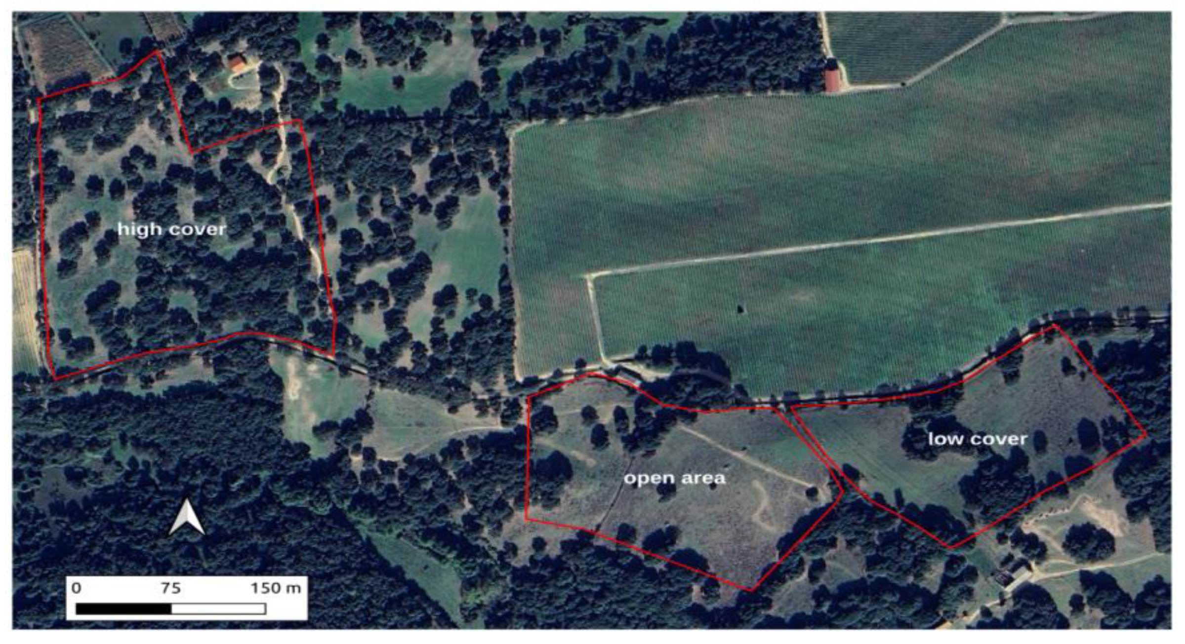
The climate is Mediterranean pluviseasonal oceanic, low mesomediterranean. The mean annual rainfall is 632 mm, 70% of which occurs from October to March; the De Martonne–Gottmann aridity index is 0.53 (De Martonne, 1942) [38]. The mean annual temperature is 14.2 °C. During the years of observation (2012–2015), the rainfall amounts in autumn and winter were 28% higher and 40% lower, respectively, in the first and second year than the pluriannual average (449 mm), while mean temperatures were similar to the long-term means (13.2, 7.8, and 22.8 °C, respectively, in autumn, winter, and spring) (Seddaiu et al. 2018) [39]. The soil is classified as Typic Dystroxerept (USDA 2022) [40]. The soil texture in the Ap horizon is that of sandy loam, with an average pH of 5.7, an organic C content of 2.3%, and a total N content of 0.2% (Seddaiu et al. 2013) [41]. The landscape is a mosaic of grasslands, vineyards, and cork oak forests, representing the dominant land use type and covering 30% of the Berchidda-Monti observatory. The natural potential tree vegetation is mainly represented by cork oak (Quercus suber L.) forests referable to Violo dehnhardtii-Quercetum suberis association (Bagella and Caria 2011) [42]. In this area, three distinct locations were identified, each exhibiting variations in canopy cover and area ranging approximately between 3 ha and 5 ha. The categorization was established through an analysis of the vertical projection of tree crowns to the ground. Using manual segmentation in QGIS (2024) [43], the total crown area was determined. The percentage of cover for each situation was thus calculated using the ratio between the sum of the crown projection area and the total field area. The resulting values were 44% for high cover, 22% for medium cover, and approximately 0% for open area (Figure 3).
The tree-covered areas were distinguished and classified through a fine resolution orthophoto from 2019 (Sardinia Autonomous Region, 2023 [44]; Pulina et al., 2022 [45]) available at https://inspire-geoportal.ec.europa.eu/srv/api/records/R_SARDEG:c82b8535-50b8-4f00-8a5e-a3ae24c33030 (accessed on 1 January 2023) (Pulina et al., 2022) [45]. The spatial distribution pattern of trees was used to distinguish fields with similar overall canopy cover but with different spatial arrangements.
The fields included in the study are within the same livestock farm, whose main activity is breeding beef cattle (Sarda and Limousine breed). During the study period, grazing was managed continuously, under normal livestock operations, with an average yearly stocking rate, expressed as livestock units (LSU of 0.6/ha−1).

2.3. Field Data Gathering

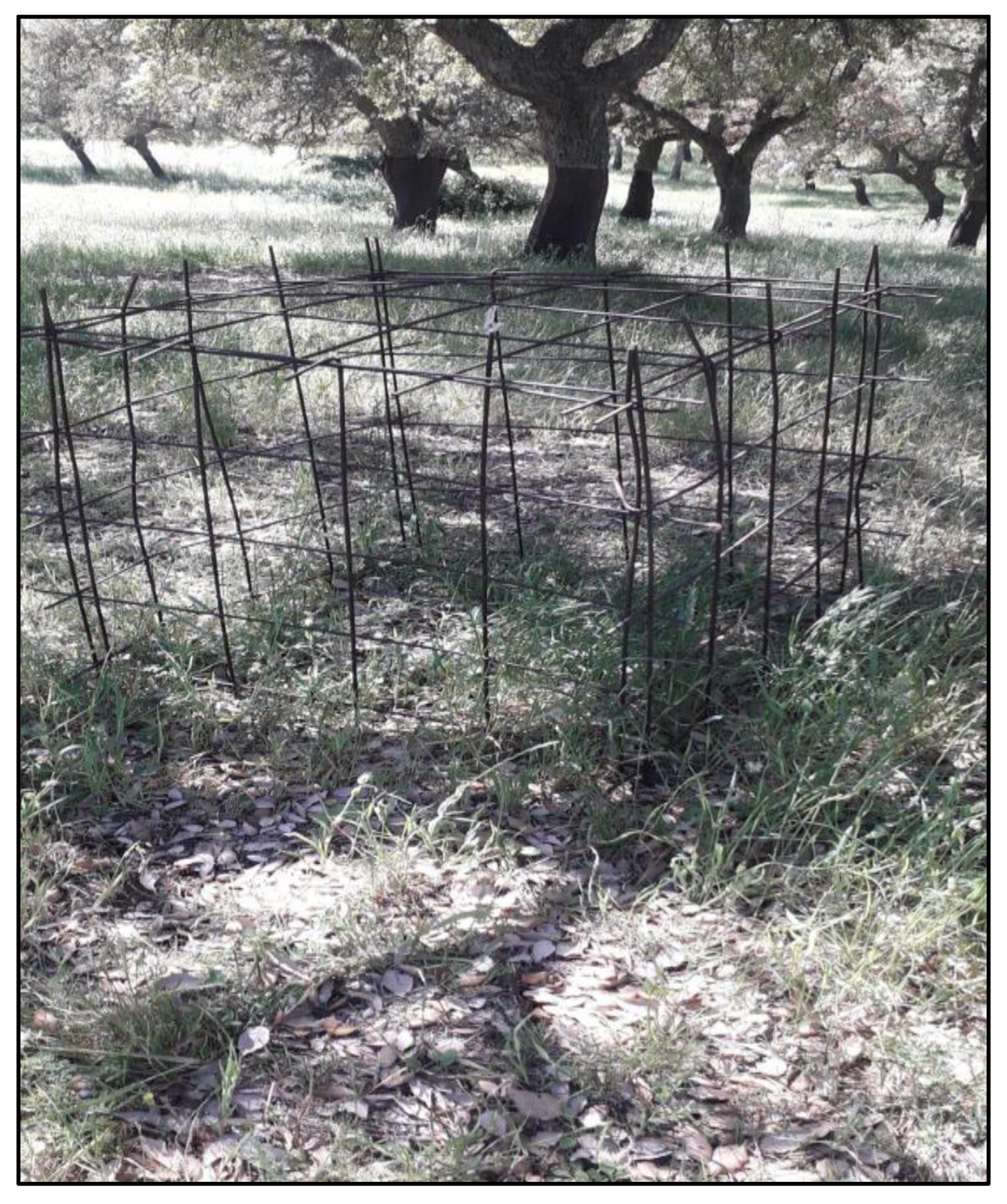
Within these three areas, various fuel models were identified, and the quantitative parameters were specifically defined through field sampling, rather than relying on pre-existing data from the literature (Rothermel, 1972 [30], Ascoli et al., 2020 [46], Campbell-Lochrie et al., 2023) [47]. Samplings were measured on a monthly basis between October 2012 and May 2015 using 1 m × 1 m movable grazing cages under randomly selected trees (Pulina et al., 2022) [45]. (Scheme 1).
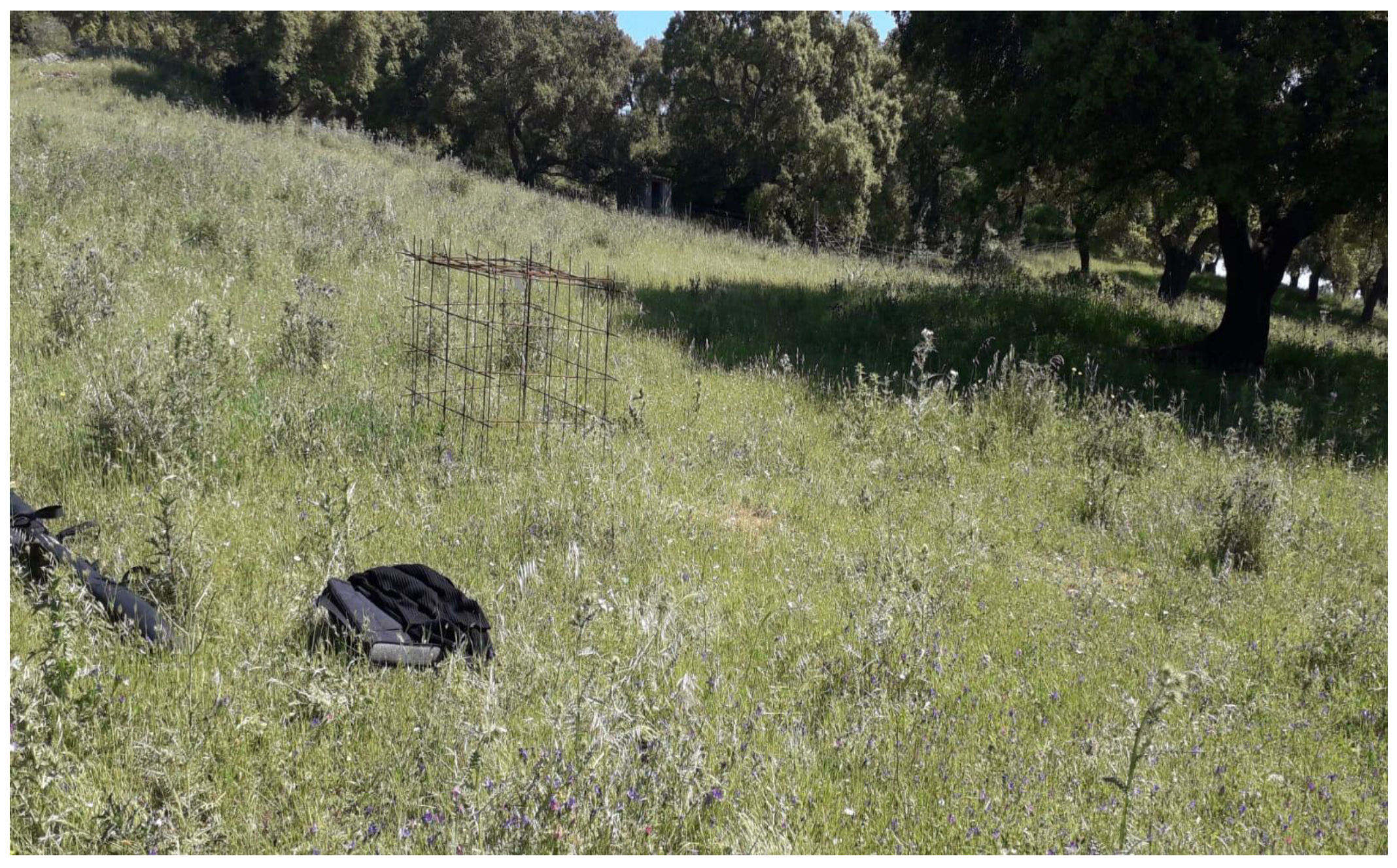
The pasture DM was calculated by sampling the phytomass both inside and outside the cages during sampling days, calculating the herbage production, the herbage intake by grazing animals, and, consequently, the pasture utilization rate (Seddaiu et al., 2018) [39] (Scheme 2).
Pasture dry matter (DM) production and residual biomass were measured monthly from October 2019 to May 2021 using 1 m × 1 m movable grazing exclusion cages (Frame, 1981). These cages were strategically placed in the sampling areas. The DM production between two sampling intervals (from day 1 to day 2) was calculated by comparing the DM biomass inside the cage on day 2 with the DM biomass outside the cage on day 1. A detailed methodology, including sampling intervals and animal intake calculations, is provided by Seddaiu et al. (2018) [39].
Seasonal dry matter was calculated by summing up intake data in seasonal windows (autumn, winter, and spring), considering the absence of pasture growth during the summer months. The collected data were incorporated in the existing dataset used to calibrate the Pasture Simulation Model (Pasim, Riedo et al., 1998) [48] for the specific conditions of the study site (Pulina et al., 2018) [37]. The herbaceous vegetation growth simulations were conducted under two management scenarios: one with grazing in the spring season with stocking rates similar to those observed in the study area (about 0.5 LSU/ha/year) and another without grazing. The simulations were performed on a daily scale over a 50-year sample (49 years) of stochastic daily weather data generated from statistics collected over the historical series from 1985–2015 using the WXGEN climate generator (Nicks et al., 1990) [49].
Monthly average temperatures and cumulative rainfall were calculated to compute the De Martonne–Gottmann aridity index, based on the De Martonne index (1942) [38], which ranges from 0 to 1. Values close to 0 indicate extreme aridity, while values above 0 indicate increasing levels of humidity. The outputs of the fuel model represented the residual biomass and the height of the herbaceous layer outside the tree canopy projection. Biomass and height under the tree canopy were estimated using a canopy-to-non-canopy ratio of 0.77 for both biomass and height, assuming a linear relationship between the variables, as observed in previous studies (Seddaiu et al., 2018; [39] Pulina et al., 2022) [45]. This provided an average value of residual biomass and herbaceous layer height corresponding to a specific climatic and management conditions. A weighted average of the estimated values was then applied based on the earlier ratio. The aridity index was used to select three particular years representing the maximum, minimum, and median values.
Tree standing biomass was analyzed through sixteen circular sampling plots (with radii ranging from 9.8 m to 29.0 m), each being centered at one of the scattered cork oak trees inside the plot. The aboveground and belowground biomasses were calculated using the allometric equations developed by the National Institute of Agricultural Research and Technology and Food of Spain (Montero et al., 2005 [50] and Pulina et al., 2022) [45].
Data from these studies were incorporated into the FlamMap system in order to simulate fire behavior within previously researched areas.

2.4. Input Data: Landscape Preparation

As previously stated, FlamMap requires the Landscape file to run the algorithm.
The eight layers of the landscape consisted of:
  • The elevation, slope, and aspect from a digital elevation model (DEM)
  • The fuel model map;
  • The characteristics of the tree canopy cover, namely, the canopy cover, canopy height, canopy base height, and bulk density.
  • Input and output raster files with a resolution of 10 m.
The fire behavior simulations were conducted in the same area where Pulina et al. (2022) [45] conducted their studies to assess the effect of tree cover on soil C balances. The simulations of herbaceous vegetation growth were conducted according to two management scenarios: (i) a scenario with grazing in the spring period with livestock loads attributable to those observed in the study area (about 0.5 LSU/ha/year) and (ii) a scenario without grazing (control area). The simulations were carried out on a sample of 50 years (49 seasons) of stochastic daily meteorological data generated from a series of statistics collected on the 1985–2015 historical series using the WXGEN climate generator (Nicks et al., 1990) [49]. The average monthly temperatures and cumulative rainfall were calculated to compute the De Martonne–Gottmann aridity index, based on the De Martonne index (1942) [38], which ranges from 0 to 1, where values close to 0 indicate extreme aridity and values greater than 0 and approaching 1 indicate increasing moisture conditions.

2.5. Definition of the Fuel Model

Biomass and height in areas under the tree canopy were estimated assuming an under-canopy/above-canopy ratio of 0.77 for both biomass and height, based on a linear relationship locally observed in other studies (Seddaiu, personal communication). To obtain a mean value of residual biomass and herbaceous layer height for a given climatic and management situation, a weighted average was applied to the values estimated using the above proportion. The aridity index (AI) was used to select three particular years that, respectively, exhibited the maximum, minimum, and median AI values. Data on vegetation for these three years were included in the fuel model.
Using this methodology, 18 fuel models were identified, with three areas with different levels of canopy cover, three years with different climate conditions, and two grazing management regimes. Simulations in FlamMap were then performed for all these combinations, assuming a constant wind speed of 30 km/h at an azimuth of 210° (southwest) and a simulation time of 20 min. A code was assigned to each fuel model (Table 1), where the first letter (G, U) referred to the grazed or ungrazed management situation; the second (H, L, O) referred to the high cover, low cover, or open area situation; and the third letter (W, M, D) referred to the three different climatic conditions selected (wet, median, dry year), respectively. The last digits referred to a progressive numbering of all the fuel models prepared. The outputs generated by the simulations, in raster format, were processed using QGIS 3.26 software. In addition to creating maps related to the main behavioral parameters, differences were made between the raster data for the grazed and ungrazed situations to visually and numerically show the significant variation in these values, if any, in different management situations (Table 1).

3. Results and Discussion

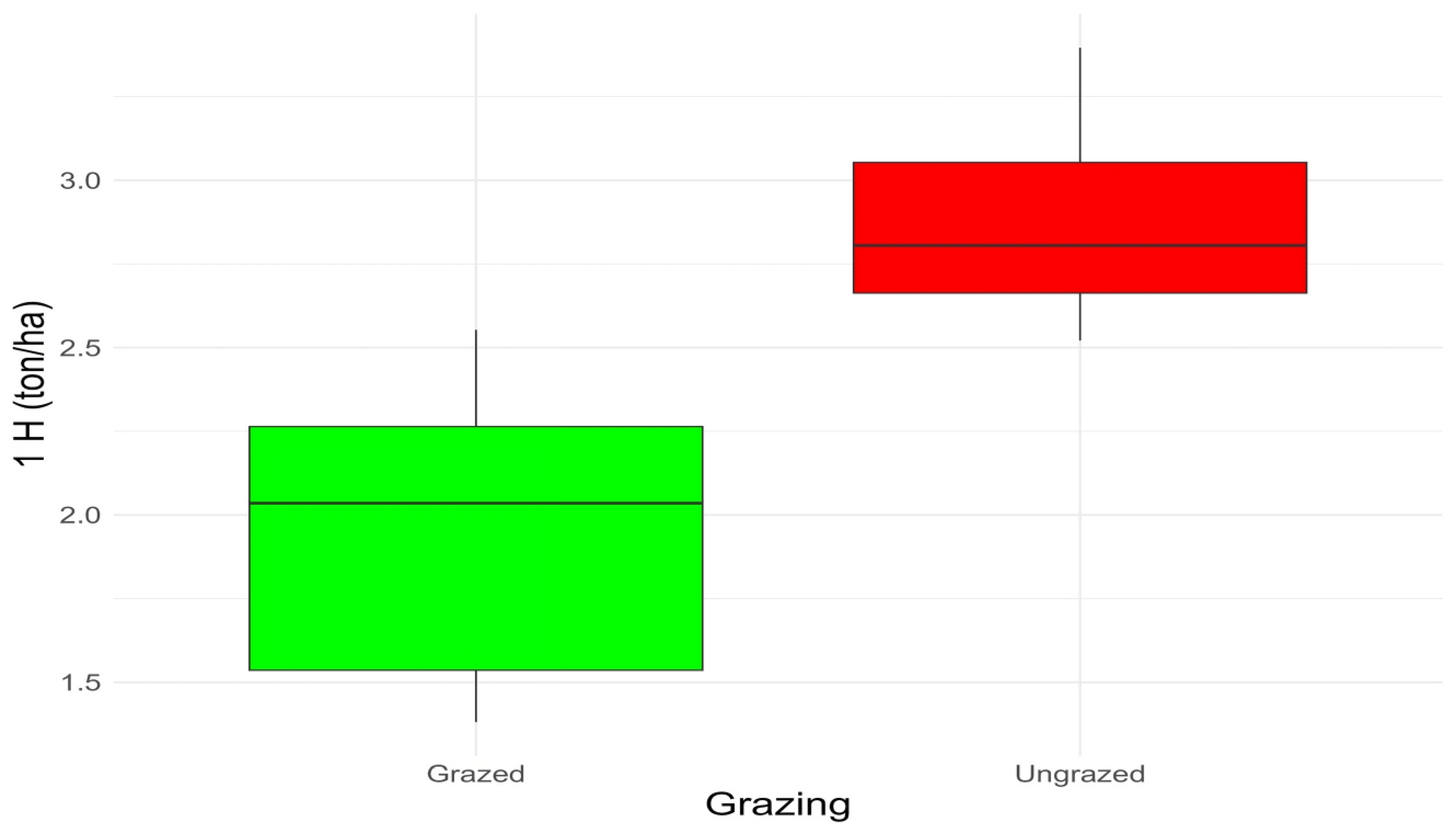
The initial findings of this research pertain to the estimation of biomass consumed by cattle during grazing and foraging. Analysis of fine fuel data (diametric class 0–0.6 cm over a 1-hectare area) indicates that approximately 33% of the biomass was removed due to grazing, with an average forage consumption of 0.75 tons per hectare (Figure 4). Additionally, recent findings (Batcheler, 2024) [51] reveal significant differences in total biomass across various understory vegetation types, particularly for grasses. Notably, silvopasture exhibited lower biomass levels compared to managed, non-grazed forest sites.
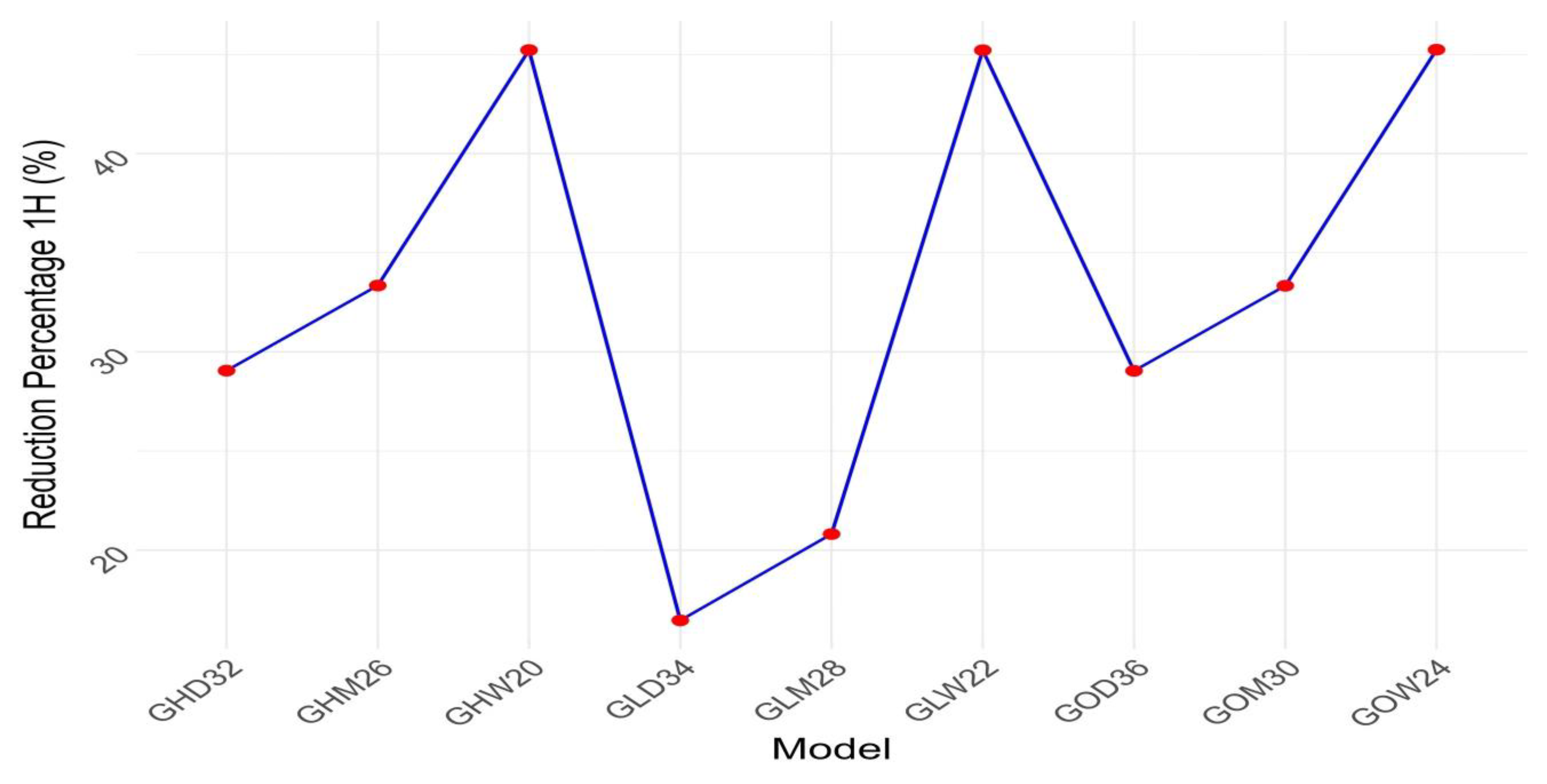
The most significant reduction in fuel loads was observed in grazed areas with high and medium tree cover during wet years, with reductions ranging from 52% to 48% (Figure 5). This phenomenon can be attributed to the enhanced microclimatic conditions present in forested areas with greater tree cover, which promote animal welfare by providing higher-quality forage (García de Jalón, 2018) [52].
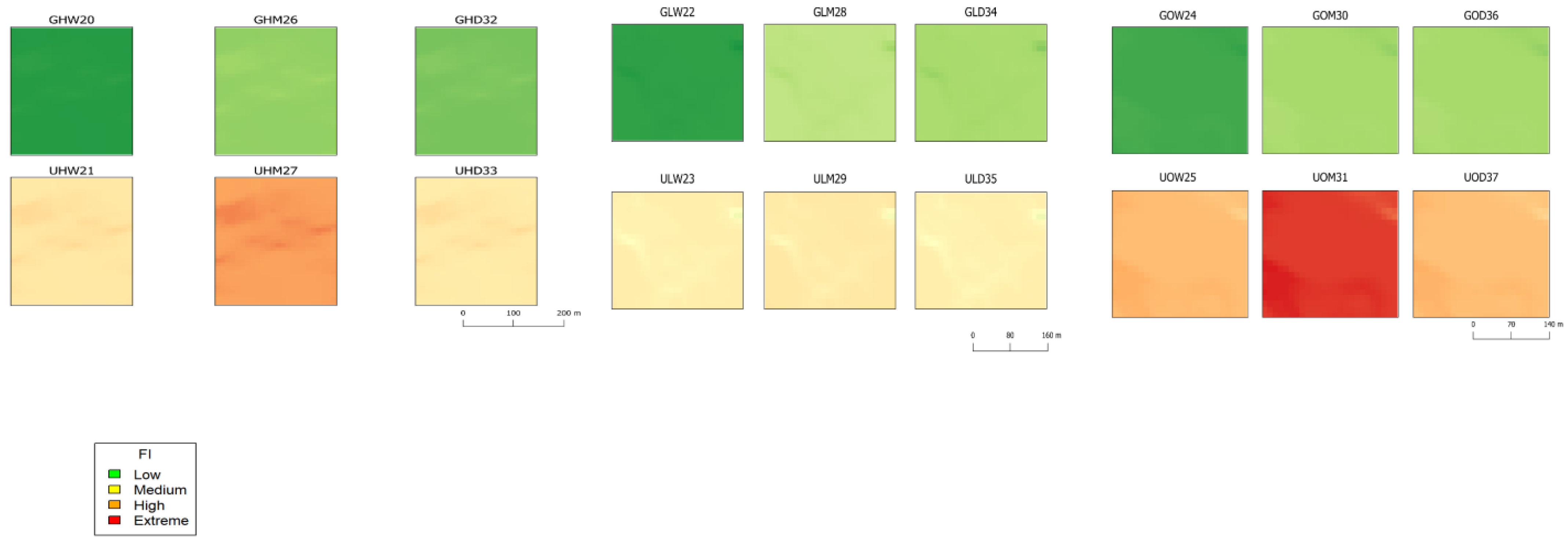
The outputs generated by the simulation with the FlamMap version 6 software (Salis et al. 2009) [34], namely, the flame length (FL), rate of spread (ROS), and fireline intensity (FLI), allowed describing the fire behavior and analyzing its severity in the investigated areas. Severity maps were generated from the model outputs within a GIS environment, categorizing severity into four classes based on flame severity values: extreme, high, medium, and low.
By generating severity maps (Figure 6) for the 18 simulation scenarios, we can visually identify areas where linear fire intensity is most critical. In this analysis, all input layers, including the elevation, slope, and aspect, were considered uniform across the entire study area. Consequently, the variations in fire behavior depicted in the maps are primarily influenced by orographic factors, the fuel load, and the extent of tree cover present. The output maps are rectangular because FlamMap requires regular geometries to function correctly.
It is evident from the cartographic processing of the severity maps (Figure 6) that:
Grazing has a profound impact on fire severity, transforming it from high to extreme levels to low levels across all grazed scenarios.
The highest severity is observed in ungrazed areas exposed to low to medium humidity, resulting in a greater accumulation of dehydrated fuel, estimated at 3.4 tons per hectare (t/ha) over a 1-hectare area.
Conversely, the lowest severity occurs in grazed regions with high tree cover and elevated humidity, which correlate with a reduced fuel load of 1.38 t/ha on a 1-hectare scale (Table 2).
A study by Shriya (2022) [53] reports reliable results on the accumulation of herbaceous biomass in relation to the cover of forest canopies, stating that the biomass of the herbaceous community outside the canopy spaces varied from 700–900 g·m2 while under the canopy it varied from 30–70 g·m−2. In the Berchidda-Monti observatory, where this study was carried out, the values range from 400 g·m−2 outside the canopy to 150 g·m−2 under the canopy (Pulina et al., 2022) [45]. The relatively reduced light for photosynthesis and competition among tree and grass roots for soil resources could be the main factors negatively affecting the amount of biomass present. It has been shown that in the event of a wildfire, the canopy structure and percentage of tree cover directly influence fire dynamics, expressed in available fuel loads and indirectly through their influence on other variables in the fire environment (Skowronski, 2020) [54]. For example, the three-dimensional structure of fuel has an influence on fuel moisture regimes, with the forest floor being consistently wetter under dense canopy. Additionally, the canopy structure additionally plays a significant role in shaping the fire environment, impacting factors that influence fire dynamics such as wind and energy flow through drag and energy absorption. Consistent with recent findings (Bertomeu et al., 2022) [55], the mosaic structure of agro-silvo-pastoral landscapes characterized by low tree cover significantly influences wildfire behavior. This is primarily due to the more uniform distribution of fuel loads and the prevalence of highly flammable fuel types with greater calorific values.
By analyzing the fire behavior parameters simulated for each fuel model, it is possible to evaluate the differences in the estimated values (Table 2). It is evident from the compiled fire behavior parameters (FL: flame length; ROS: rate of spread; FLI: fireline intensity) that the values distinctly differ between the fuel model parameters in the grazed and ungrazed areas. In all the fuel models in which absence of grazing did not reduce the fuel biomass, the diffusion, energy, and flame height parameters were significantly higher than in the areas in which grazing was able to exert its preventive reduction function on the fuel. For greater clarity in reading the results and the differences that emerge from the comparison of grazed and non-grazed areas in terms of fire behavior, separate graphs have been produced for each individual behavior parameter (FL: flame length; ROS: rate of spread; FLI: fireline intensity) (Figure 7, Figure 8 and Figure 9 obtained from the data of Table 2).
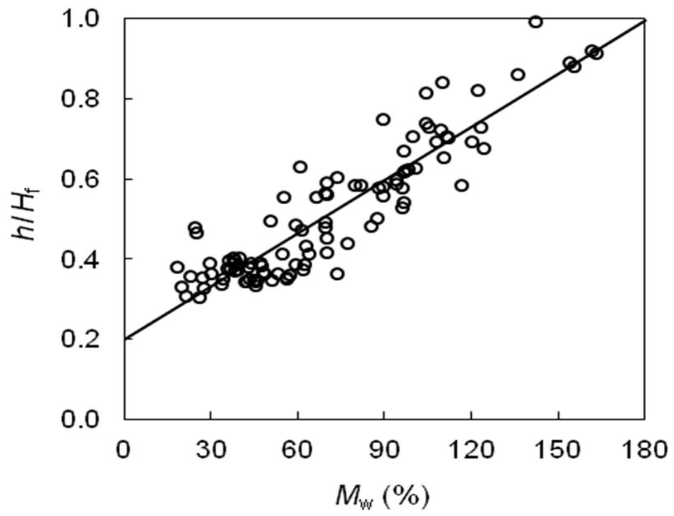
From the graphs, the highest flame heights are recorded in the UOM31 (ungrazed open area median year) fuel model, since the fuel height is higher (Figure 7). Our data are aligned with Rossa and Fernandes (2017) [56], who highlights the strong correlation between the height of the fuel and the height of the flames of a forest fire. Flames always develop above the fuel bed (Hf > h) in well-sustained fires, which means that h/Hf < 1 (Figure 10). The structural parameter with the greatest influence on flame dimensions is wind, which is highly correlated with h in natural fuel complexes (Fernandes et al. 2009 [57], Rossa and Fernandes (2017) [56]).
Regarding the fire line intensity parameter (Figure 8), the fuel model with the highest value is UOM31 (ungrazed open area median year) due to the higher fuel load, which directly influences flame behavior (Byram, 1959) [58]. The linear intensity parameter is extremely related to the charge and calorific value of the fuel present. In fact, the heat released per unit length of the fire line per unit time (IL) is calculable using the Byram formula (Byram, 1959) [58] as follows:
I = 0.007 × HV × (WD W0) × R
where I is the intensity of the fire line (kW·m−1), HV is the calorific value of the fuel (kJ/g), W0 is the weight of the residual ash after combustion (g), WD is the weight of the oven-dried fuel bed (g), and R is the spread rate (Jibin, 2022).
In Figure 9, it is evident that the rate of spread parameter is higher in the UHM27 (ungrazed high-cover area median year) fuel model due to the reduced frictional effect of vegetation on the wind. The friction is influenced by the characteristics of the vegetation, which cause the wind speed to vary with the height of the vegetation. Generally, wind speed is lower within the vegetative layer compared to the upper undergrowth (Andrews, 2012) [59]. Among the studied areas, herbaceous vegetation exhibited a lower frictional effect compared to areas with different canopy coverage, resulting in a higher rate of spread.
The rate of spread values calculated with the Flammap program are based on the Rothermel model (Rothermel, 1972) [30], which utilizes the principle of conservation of energy. This model describes the steady-state diffusion rate ® as the ratio between the energy released to the unburned fuel and the energy needed for ignition. Regarding the fire line intensity parameter (Figure 8), the UOM31 (ungrazed open area median year) fuel model exhibits the highest value due to its greater fuel load. The rate of spread values calculated with the Flammap program are based on the well-known Rothermel model (Rothermel 1972) [30].
In Figure 9, it is evident that the rate of spread parameter is higher in the UHM27 (ungrazed high-cover area median year) fuel model, primarily due to the higher fuel load, which directly influences flame behavior (Byram, 1969) [58]. Conversely, the influence of the frictional effects of vegetation on the wind is significantly lower. The variation in wind speed due to the height of vegetation is notable; wind speed is typically lower in the vegetative layer compared to the upper-layer undergrowth (Andrews, 2012) [59]. In our case, the impact of frictional effects is outweighed by the impact of the fuel load, especially since the Rothermel model assumes effects at a height of 2.00 m from ground, which is significantly higher than the height of the grass in our scenario. Figure 8, Figure 9 and Figure 10 depict the differences in the fuel model scenarios.
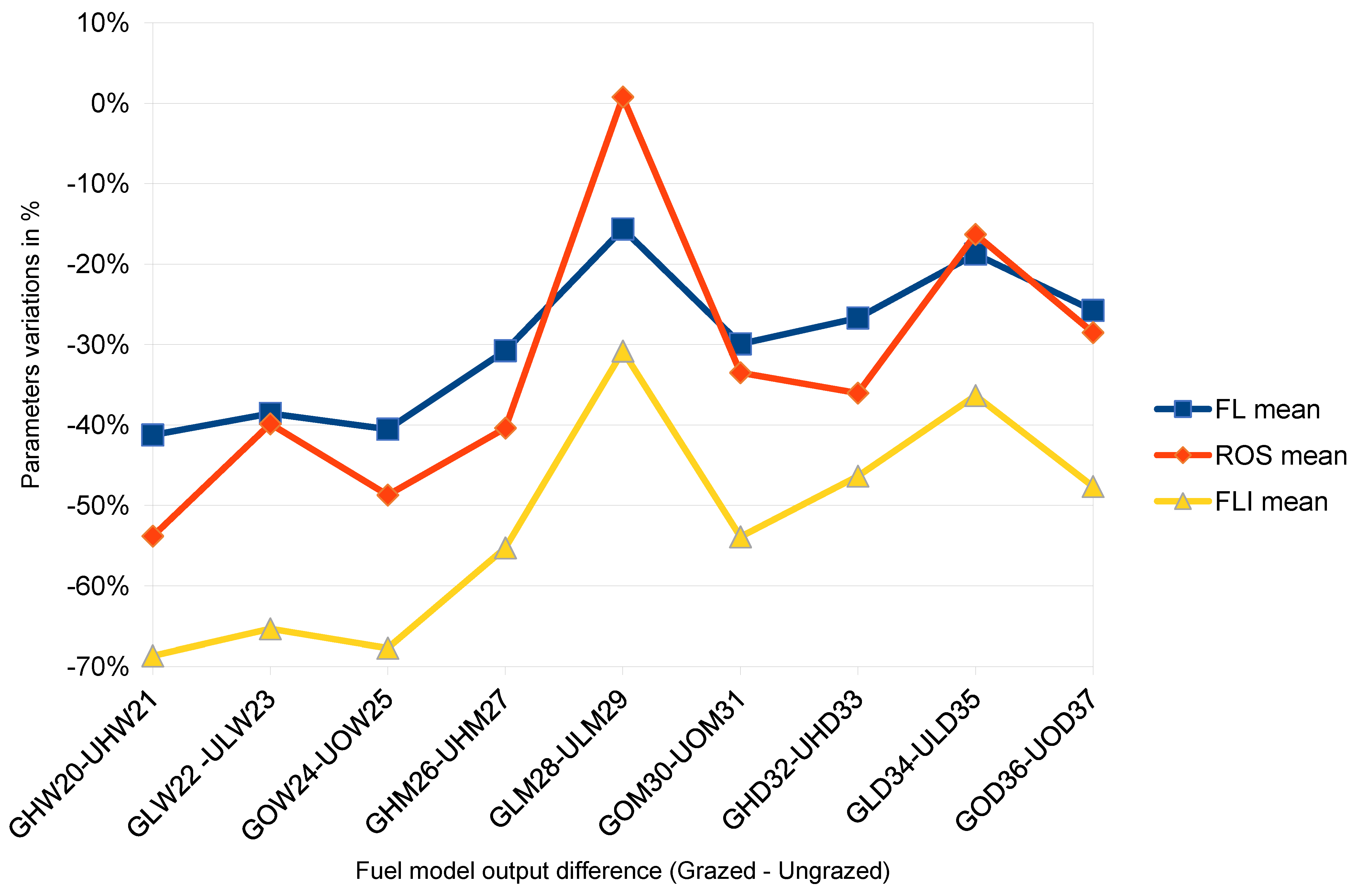
In Table 3 and Figure 11, we summarize the values of fire behavior in the areas and under the conditions where grazing has significantly contributed to the reduction in fire behavior parameters. Table 3 displays the percentage reduction in the FL mean, ROS mean, and FLI mean parameters between ungrazed and grazed areas. The most significant reduction was observed in areas with high canopy cover in the wet year (GHW20–UHW21), where, in this case, grazing practice decreased FL, ROS, and FLI by 41%, 58%, and 68%, respectively. In nearly all the studied combination scenarios, grazing was proven to be effective in reducing the severity of fire parameters, resulting in reductions in their values ranging from 15% to 68%. Analyzing the data in Table 3, we observe that the greatest reduction in flame height occurred in areas without canopy cover during the wet year (GHW20). This is because grazing significantly reduced the fuel thickness. In the absence of grazing, the situation can be quite different. During rainy years and without canopy cover, grasses tend to grow more abundantly, leading to an increase in fuel load and, consequently, higher flame heights (UHW21).
Regarding the fire spread rate parameter, grazing had the greatest influence in areas with high canopy cover during the wetter year. This is due to the frictional effect of vegetation on the wind.
For fireline intensity, grazing showed a greater impact in both areas with no canopy cover in the wet year and in areas with median canopy cover. This phenomenon can be attributed to the significant reduction in fuel load resulting from grazing, which occurs primarily in areas with favorable micro-stationary conditions that enhance animal welfare by providing higher quality forage. To detect significant differences between the fire behavior parameters, a two-way ANOVA was conducted for all three parameters. In all cases, the grazing factor significantly influenced the severity of the potential fire parameters.
For flame length (FL), grazing had the highest significance (p < 0.001), as did climatic conditions (p < 0.001). However, the interaction between these two factors, while still significant, was lower (p < 0.05). Similarly, for fireline intensity (FLI), both grazing and climatic conditions were highly significant (p < 0.001). In this case, the interaction between the two factors did not reach statistical significance. Regarding the rate of spread (ROS), grazing remained the most influential factor (p < 0.01). However, canopy cover and the interaction between cover and grazing also showed statistical significance (p < 0.05). These results confirm that grazing is the most crucial factor in reducing the parameters that indicate the severity of potential fires.
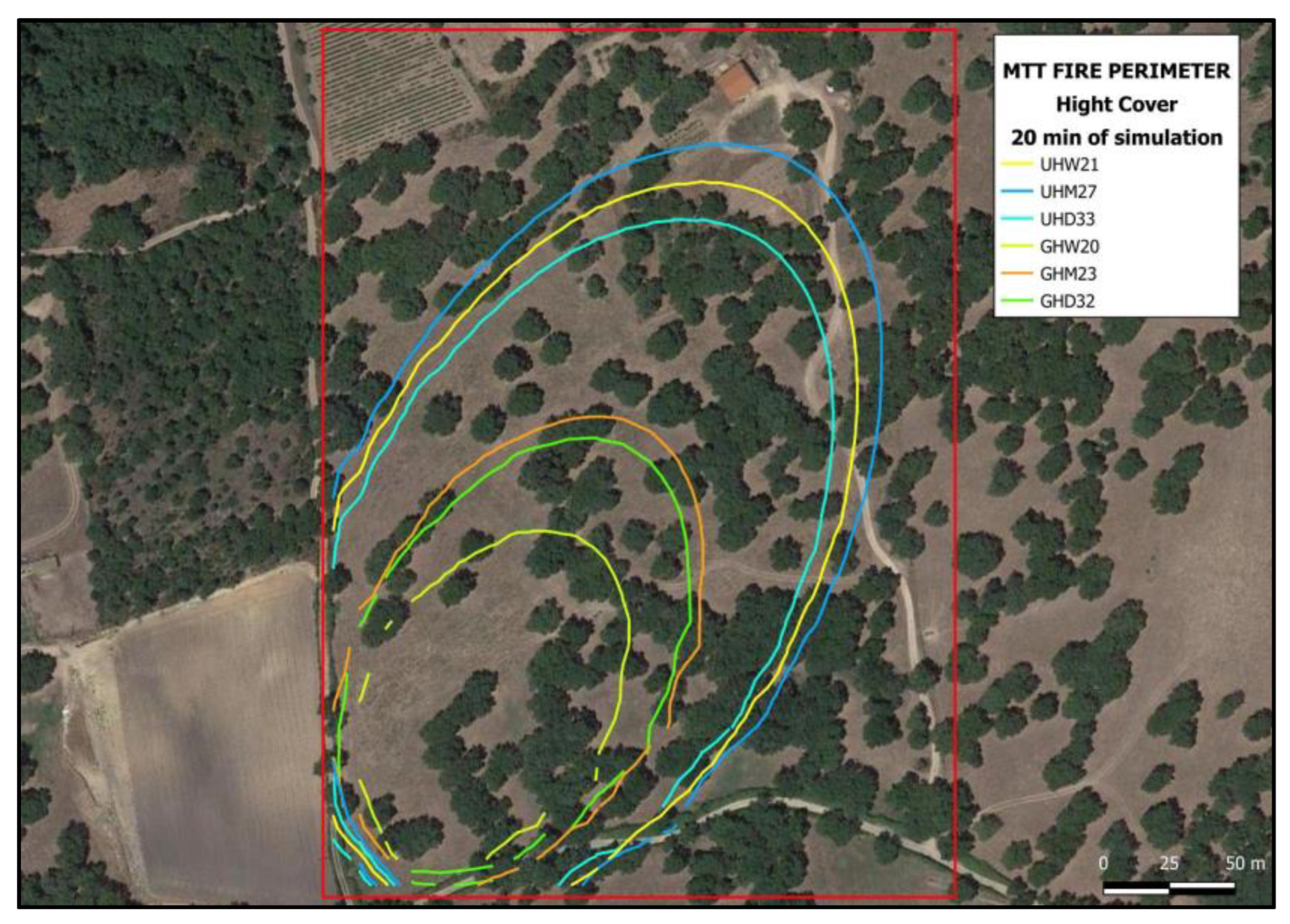
Using the minimum travel time (MTT) technique, a map was generated from a single ignition point, showing only the area characterized by high canopy cover (HCA) (Figure 12). Table 4 quantifies the extent of fires generated in simulations relative to the effect of grazing. It is evident that within the high canopy cover area, the most extensive fire occurred under the non-grazed condition in the wet year. Due to grazing, the extent of fire was reduced by 25.9% in the wettest year, 60.9% in the median year, and 45.8% in the dry year. The variation in fire reduction between the wettest and median years can be attributed to the differential biomass production and moisture content of the dead fuel. In the wettest year, there was a substantial increase in biomass production, and with a constant livestock load, the proportional intake by livestock was proportionally lower. Conversely, in the median year, biomass production was reduced. Because of the constant livestock load, the proportional intake, though comparable, was proportionally greater.
The analyses conducted in this research yielded distinct results that affirm the study’s objective: to evaluate the impact of pasture presence on biomass levels and, consequently, the vulnerability to and severity of forest fires across various tree types in Sardinia. The following results highlight the key findings of this study:
  • Biomass Consumption: The biomass consumed by grazing cattle through forage feeding was estimated, revealing that approximately 33% of the fine fuel data (1 ha diameter class 0–0.6 cm) was eliminated due to grazing, which averaged 0.75 t/ha of forage.
  • Severity Mapping: Cartographic processing of severity maps indicated that grazing significantly reduced fire severity. Areas that remained ungrazed exhibited higher severity in low to medium humidity environments, with a fuel load of 3.4 t/ha, whereas grazed areas with high tree cover and humidity recorded a lower fuel load of 1.38 t/ha.
  • Impact of Grazing: The most significant reductions in fire-related parameters (FL, ROS, and FLI) occurred in high-canopy cover areas during wet years (GHW20–UHW21), with decreases of 41%, 58%, and 68%, respectively. Across nearly all studied scenarios, grazing effectively mitigated fire severity, achieving reductions ranging from 15% to 68%.
  • Statistical Analysis: ANOVA confirmed that grazing is a critical factor in reducing parameters indicative of fire severity, solidifying its role in fire management strategies.
  • Fire Spread Reduction: Utilizing the minimum travel time (MTT) technique, a map generated from a single ignition point demonstrated that grazing reduced the extent of fire spread by 25.9% in wet years, 60.9% in median years, and 45.8% in dry years.
This study aligns with existing research on grazing as an effective wildfire mitigation tool in Mediterranean environments, supporting findings by Lovreglio et al. (2014) [26] and Rouet-Leduc et al. (2021) [7] that highlight grazing’s role in reducing fine fuel loads and lowering wildfire intensity. Like previous studies, including) our research demonstrates that combining grazing with other vegetation management practices, such as thinning and controlled burning, can be highly effective in managing wildfire risk by reducing vegetation height and biomass. Additionally, projects like LIFE Montserrat and Graze LIFE showcase how grazing contributes to biodiversity and ecological resilience by maintaining open habitats and interrupting fuel continuity, which aligns with our findings in Sardinia that grazed, high-canopy areas exhibit reduced fire behavior.
Our study adds to these insights by uniquely examining grazing’s effectiveness across variable climatic conditions, revealing that grazing’s benefits vary significantly with rainfall-driven biomass fluctuations. This aligns with Batcheler (2024) [51], who observed that livestock consumption is highly responsive to annual vegetation growth, suggesting that grazing strategies could be adapted dynamically based on yearly climate conditions. Furthermore, unlike other studies that focus on open or scrubland ecosystems, our findings on the influence of canopy cover density highlight that shaded, high-canopy areas benefit more from grazing due to combined effects on microclimate and fuel reduction.

4. Conclusions

The new National Forest Strategy (https://www.gazzettaufficiale.it/eli/id/2022/02/09/22A00834/sg, accessed on 1 January 2023) (NFS) in Italy aims not only to improve forest adaptation to climate change, but also to promote large-scale forest management interventions for the prevention of forest fires and extreme natural events. In particular, the NFS aims to increase prevention through integrated planning measures, giving particular importance to agro-silvo-pastoral practices that allow for the strategic management of fuel load reduction to support fire defense. The practice of grazing is deeply rooted in traditional Mediterranean landscapes and is represented as a model of sustainable management and conservation of natural resources. It is also an important example of nature-based solution (NBS) procedures related to hazard suppression, as it helps diminish socio-ecological vulnerabilities.
Fire-smart policies advocate for nature-based solutions (NBS) as effective strategies for fostering fire-resilient landscapes. Prescribed grazing emerges as one of the most effective measures for achieving these conditions, as it helps reduce socio-ecological vulnerability and promotes a shift towards prevention rather than suppression of wildfires. A particularly promising strategy is the “Fire Smart Territory” model, which emphasizes the importance of proactive measures in addition to emergency response. This conceptual framework underscores the necessity of focusing on prevention to mitigate fire risks effectively.
Among the most sustainable interventions in preventive forestry, aimed at reducing the most dangerous types of fuel, is the use of grazing, which has long been recognized as a fire prevention tool. Its use has a long history in Italy: it was already mentioned in Article 3 of Law 47/75 (now abolished and replaced by Law 353/2000 and successively by Law nr. 155/2021), explicitly authorizing “the introduction of bovine, sheep, and pig livestock into forests, in accordance with the plans, in order to use their forage resources to achieve the spontaneous cleaning of the forest.” Our research conducted in Sardinia, where pastoral activities have significantly shaped the landscape and rural culture, including the traditional use of fire as a tool, clearly demonstrates that grazed areas are the least vulnerable to fire. Therefore, the practice of grazing proves effective in mitigating the impact of fires. This confirms that grazing, when managed and implemented in a planned and targeted manner to reduce fuel loads, is a valuable economical, ecological, and sustainable tool for fire prevention. Conducting studies like this one is crucial for objectively identifying where prescribed grazing practices can be effectively implemented across various vegetation formations. Such prevention strategies are vital for effective fire management, particularly in Mediterranean environments characterized by agro-silvo-pastoral systems.
In conclusion, grazing within forest ecosystems serves as a natural management tool that optimally utilizes forage and reduces fuel loads. This research indicates that livestock grazing can lead to an average reduction of 33% in herbaceous fuel loads and height, significantly mitigating fire severity. Specifically, it was observed that grazing reduced the flame length (FL), rate of spread (ROS), and flame intensity (FLI) by 41%, 54%, and 68%, respectively. However, this study is limited by its focus solely on small-sized plant biomass (1-h fuels). Future research should expand to assess the impact of prescribed grazing on larger fuel categories (10-h and 100-h), thereby providing a more comprehensive understanding of its role in fire management and enhancing the resilience of Mediterranean landscapes against wildfires.
If required, here is a more concise version of the conclusion, even though the authors do not see the need to change it as such:
The National Forest Strategy (NFS) in Italy emphasizes proactive fire prevention through integrated, large-scale forest management, with a focus on agro-silvo-pastoral practices like prescribed grazing. Grazing, deeply rooted in Mediterranean landscapes, is recognized as a nature-based solution (NBS) that reduces fuel loads and mitigates socio-ecological vulnerabilities. Our study in Sardinia demonstrates that grazing significantly lowers wildfire risk, reducing the flame length, rate of spread, and intensity by 41%, 54%, and 68%, respectively. This confirms grazing as an effective, sustainable tool for wildfire prevention when strategically managed. Although this research focuses on smaller fuel loads (1-h fuels), future studies should explore its impact on larger fuels (10-h and 100-h) to provide a fuller understanding of grazing’s role in Mediterranean fire management and resilience.

Author Contributions

Conceptualization, R.L.; methodology and analysis tools, R.L., J.L., G.G.A.S., M.M. and A.P.; data gathering, G.G.A.S. and A.P.; formal analysis, G.G.A.S., M.M. and A.P.; writing—original draft preparation, R.L., J.L., G.G.A.S., M.M. and A.P.; writing—review and editing, R.L., J.L., M.M. and A.P.; supervision, R.L.; paper coordination, R.L.; corresponding author, R.L. All authors have read and agreed to the published version of the manuscript.

Funding

This research was supported by the GASPAM project of the Sardinia Region year 2017.

Institutional Review Board Statement

Not applicable.

Informed Consent Statement

Informed consent was obtained from all subjects involved in the study.

Data Availability Statement

The original contributions presented in the study are included in the article, further inquiries can be directed to the corresponding author.

Acknowledgments

During the preparation of this work the author(s) used ChatGPT in order to facilitate data analysis and to improve readability and language. After using this tool/service, the author(s) reviewed and edited the content as needed and take(s) full responsibility for the content of the publication.

Conflicts of Interest

The authors declare no conflict of interest.

References

  1. Rovithakis, A.; Grillakis, M.G.; Seiradakis, K.D.; Giannakopoulos, C.; Karali, A.; Field, R.; Lazaridis, M.; Voulgarakis, A. Future climate change impact on wildfire danger over the Mediterranean: The case of Greece. Environ. Res. Lett. 2022, 17, 045022. [Google Scholar] [CrossRef]
  2. San-Miguel-Ayanz, J.; Durrant, T.; Boca, R.; Maianti, P.; Liberta, G.; Artes Vivancos, T.; Jacome Felix Oom, D.; Branco, A.; De Rigo, D.; Ferrari, D.; et al. Forest Fires in Europe, Middle East and North Africa; EUR 31269 EN; Publications Office of the European Union: Luxembourg, 2021. [Google Scholar]
  3. IPBES. Global Assessment Report on Biodiversity and Ecosystem Services of the Intergovernmental Science-Policy Platform on Biodiversity and Ecosystem Services; Brondizio, E.S., Settele, J., Díaz, S., Ngo, H.T., Eds.; IPBES Secretariat: Bonn, Germany, 2019; 1148p. [Google Scholar]
  4. Simpson, C.; Bonjean, I.; Fornara, M.; Jonkers, K.; Klaassen, T.; Lehto, S.; Soldatova, L.; Thielen Del Pozo, J.; Westra Van Holthe, M. (Eds.) JRC Highlights Report; Publications Office of the European Union: Luxembourg, 2024. [Google Scholar]
  5. Silva, P.; Carmo, M.; Rio, J.; Novo, I. Changes in the Seasonality of Fire Activity and Fire Weather in Portugal: Is the Wildfire Season Really Longer? Meteorology 2023, 2, 74–86. [Google Scholar] [CrossRef]
  6. Turco, M.; Rosa-Cánovas, J.J.; Bedia, J.; Jerez, S.; Montávez, J.P.; Llasat, M.C.; Provenzale, A. Exacerbated fires in Mediterranean Europe due to anthropogenic warming projected with non-stationary climate-fire models. Nat. Commun. 2018, 9, 3821. [Google Scholar] [CrossRef]
  7. Rouet-Leduc, J.; Pe’Er, G.; Moreira, F.; Bonn, A.; Helmer, W.; Zadeh, S.A.A.S.; Zizka, A.; van der Plas, F. Effects of large herbivores on fire regimes and wildfire mitigation. J. Appl. Ecol. 2021, 58, 2690–2702. [Google Scholar] [CrossRef]
  8. Moreira, F.; Ascoli, D.; Safford, H.; A Adams, M.; Moreno, J.M.; Pereira, J.C.; Catry, F.X.; Armesto, J.; Bond, W.J.; E González, M.; et al. Wildfire management in Mediterranean-type regions: Paradigm change needed. Environ. Res. Lett. 2020, 15, 011001. [Google Scholar] [CrossRef]
  9. Ascoli, D.; Plana, E.; Oggioni, S.D.; Tomao, A.; Colonico, M.; Corona, P.; Moreno, F.; Xanthopoulos, G.; Kaoukis, K.; Athanasiou, M.; et al. Fire-smart solutions for sustainable wildfire risk prevention: Bottom-up initiatives meet top-down policies under EU green deal. Int. J. Disaster Risk Reduct. 2023, 92, 103715. [Google Scholar] [CrossRef]
  10. Oikonomou, D.; Vrahnakis, M.; Yiakoulaki, M.; Xanthopoulos, G.; Kazoglou, Y. Grazing as a management tool in Mediterranean Pastures: A meta-analysis based on a literature review. Land 2023, 12, 1290. [Google Scholar] [CrossRef]
  11. Ribeiro, I.; Domingos, T.; McCracken, D.; Proença, V. The use of domestic herbivores for ecosystem management in Mediterranean Landscapes. Glob. Ecol. Conserv. 2023, 46, e02577. [Google Scholar] [CrossRef]
  12. Smit, I.P.J.; Coetsee, C. Interactions Between Fire and Herbivory: Current Understanding and Management Implications. In The Ecology of Browsing and Grazing II. Ecological Studies; Gordon, I., Prins, H., Eds.; Springer: Cham, Switzerland, 2019; Volume 239. [Google Scholar]
  13. Allen, V.G.; Batello, C.; Berretta, E.J.; Hodgson, J.; Kothmann, M.; Li, X.; McIvor, J.; Milne, J.; Morris, C.; Peeters, A.; et al. An international terminology for grazing lands and grazing animals. Grass Forage Sci. 2011, 66, 2–28. [Google Scholar] [CrossRef]
  14. Vacchiano, G.; Foderi, C.; Berretti, R.; Marchi, E.; Motta, R. Modeling anthropogenic and natural fire ignitions in an inner-Alpine valley. Nat. Hazards Earth Syst. Sci. 2018, 18, 935–948. [Google Scholar] [CrossRef]
  15. Starns, H.D.; Fuhlendorf, S.D.; Elmore, R.D.; Twidwell, D.; Thacker, E.T.; Hovick, T.J.; Luttbeg, B. Recoupling fire and grazing reduces wildland fuel loads on rangelands. Ecosphere 2019, 10, e02578. [Google Scholar] [CrossRef]
  16. Ngugi, M.W.; Kimuyu, D.M.; Sensenig, R.L.; Odadi, W.O.; Kiboi, S.K.; Omari, J.K.; Young, T.P. Fire and herbivory interactively suppress the survival and growth of trees in an African semiarid savanna. Fire 2022, 5, 169. [Google Scholar] [CrossRef]
  17. Kramer, K.; Groen, T.; van Wieren, S. The interacting effects of ungulates and fire on forest dynamics: An analysis using the model FORSPACE. For. Ecol. Manag. 2003, 181, 205–222. [Google Scholar] [CrossRef]
  18. Pausas, J.G.; Keeley, J.E. Abrupt climate-independent fire regime changes. Ecosystems 2014, 17, 1109–1120. [Google Scholar] [CrossRef]
  19. Bachelet, D.; Lenihan, J.M.; Daly, C.; Neilson, R.P. Interactions between fire, grazing and climate change at Wind Cave National Park, SD. Ecol. Model. 2000, 134, 229–244. [Google Scholar] [CrossRef]
  20. Wagner, M.; Waterton, C.; Norton, L.R. Mob grazing: A nature-based solution for British farms producing pasture-fed livestock. Nat.-Based Solut. 2023, 3, 100054. [Google Scholar] [CrossRef]
  21. Li, D.; Zhang, M.; Lü, X.; Hou, L. Does nature-based solution sustain grassland quality? evidence from rotational grazing practice in China. J. Integr. Agric. 2023, 22, 2567–2576. [Google Scholar] [CrossRef]
  22. Cohen-Shacham, E.; Walters, G.; Janzen, C.; Maginnis, S. (Eds.) Nature-Based Solutions to Address Global Societal Challenges; Imprint Gland IUCN: Gland, Switzerland, 2016. [Google Scholar]
  23. Bayer, J.; Bacciu, V.; Plana, E.; Sousa, L.; Surminski, S.; Deubelli-Hwang, T. Nature-based solutions for Wildfire Risk Management. In Proceedings of the EGU General Assembly, Vienna, Austria, 23–28 April 2023. [Google Scholar]
  24. Launchbaugh, K.; Walker, J. Targeted grazing—A new paradigm for livestock management. In Targeted Grazing: A Natural Approach to Vegetation Management and Landscape Enhancement; Launchbaugh, K., Ed.; American Sheep Industry Association ASI: Washington, DC, USA, 2006; p. 8. [Google Scholar]
  25. Ainalis, A.B.; Platis, P.D.; Meliadis, I.M. Grazing effects on the sustainability of an oak coppice forest. For. Ecol. Manag. 2010, 259, 428–432. [Google Scholar] [CrossRef]
  26. Lovreglio, R.; Meddour-Sahar, O.; Leone, V. Goat grazing as a wildfire prevention tool: A basic review. iForest 2014, 7, 260–268. [Google Scholar] [CrossRef]
  27. Huntsinger, L.; Barry, S. Grazing in California’s Mediterranean multi-firescapes. Front. Sustain. Food Syst. 2021, 5, 24. [Google Scholar] [CrossRef]
  28. Castaldo, A.G. On the Quest of Prescribed Grazing Multi-Functionality in Mediterranean A Nature-Based Solutions Framework for Wildfire Risk Management. Ph.D. Thesis, Politecnico di Milano, Millan, Italy, 2023. [Google Scholar]
  29. Finney, M.A. An overview of FlamMap fire modeling capabilities. In Fuels Management—How to Measure Success: Conference Proceedings. RMRS-P-41; Andrews, P.L., Butler, B.W., Eds.; USDA Forest Service, Rocky Mountain Research Station: Portland, OR, USA, 2006; pp. 213–220. [Google Scholar]
  30. Rothermel, R.C. A mathematical model for predicting fire spread in wildland fuels. In Research Paper INT-115, USDA Forest Service; Intermountain Forest and Range Experiment Station: Ogden, UT, USA, 1972; p. 40. [Google Scholar]
  31. Life Montserrat Project Team. LIFE Montserrat: Enhancing Forest Resilience Through Grazing and Ecosystem-Based Management in Catalonia, Spain. European Union LIFE Programme. 2024. Available online: www.lifemontserrat.eu (accessed on 1 January 2023).
  32. Ning, J.; Yang, G.; Liu, X.; Geng, D.; Wang, L.; Li, Z.; Zhang, Y.; Di, X.; Sun, L.; Yu, H. Effect of fire spread, flame characteristic, fire intensity on particulate matter 2.5 released from surface fuel combustion of Pinus koraiensis plantation—A laboratory simulation study. Environ. Int. 2022, 166, 107352. [Google Scholar] [CrossRef] [PubMed]
  33. Farsite, F.M. Fire Area Simulator-Model Development and Evaluation. Research Paper RMRS-RP-4; revised 2004; USDA Forest Service, Rocky Mountain Research Station: Ogden, UT, USA, 1998; 47p.
  34. Salis, M.; Arca, B.; Bacciu, V.; Duce, P.; Spano, D. Assessment of fire severity in a mediterranean area using FlamMap simulator. In Proceeding of the VIII Symposiumon on Fire and Forest Meteorology, Kalispell, MT, USA, 13–15 October 2009. [Google Scholar]
  35. Arca, B.; Pellizzaro, G.; Duce, P.; Salis, M.; Bacciu, V.; Spano, D.; Ager, A.; Scoccimarro, E. Potential changes in fire probability and severity under climate change scenarios in Mediterranean areas. Model. Fire Behav. Risk 2012, 1, 92–98. [Google Scholar]
  36. Arpaci, A.; Vacik, H.; Valese, E. Potential Fire Intensities in the Alpine Region based on characteristic fuels in Austria and Italy. In Proceedings of the 5th International Wildland Fire Conference, Sun City, South Africa, 9–13 May 2011. [Google Scholar]
  37. Pulina, A.; Lai, R.; Salis, L.; Seddaiu, G.; Roggero, P.P.; Bellocchi, G. Modeling pasture production and soil temperature, water and carbon fluxes in Mediterranean grassland systems with the Pasture Simulation model. Grass Forage Sci. 2018, 73, 272–283. [Google Scholar] [CrossRef]
  38. De Martonne, E. Nouvelle carte mondiale de l’indice d’aridité. Ann. Géogr. 1942, 51, 242–250. (In French) [Google Scholar] [CrossRef]
  39. Seddaiu, G.; Bagella, S.; Pulina, A.; Cappai, C.; Salis, L.; Rossetti, I.; Lai, R.; Roggero, P.P. Mediterranean cork oak wooded grasslands: Synergies and trade-offs between plant diversity, pasture production and soil carbon. Agrofor. Syst. 2018, 92, 893–908. [Google Scholar] [CrossRef]
  40. USDA. Soil Survey Staff Keys to Soil Taxonomy, 13th ed.; USDA-Natural Resources Conservation Service: Washington, DC, USA, 2022.
  41. Seddaiu, G.; Porcu, G.; Ledda, L.; Roggero, P.P.; Agnelli, A.; Corti, G. Soil organic matter content and composition as influenced by soil management in a semi-arid Mediterranean agro-silvo-pastoral system. Agric. Ecosyst. Environ. 2013, 167, 1–11. [Google Scholar] [CrossRef]
  42. Bagella, S.; Caria, M.C. Vegetation series: A tool for the assessment of grassland ecosystem services in Mediterranean large-scale grazing systems. Fitosociologia 2011, 48, 47–54. [Google Scholar]
  43. UCP Knowledge Network. The Value of Grazing as a Wildfire Prevention Tool. European Civil Protection Knowledge Network. 2024. Available online: https://civil-protection-knowledge-network.europa.eu/ (accessed on 1 January 2023).
  44. Jose, S.; Dollinger, J. Silvopasture: A sustainable livestock production system. Agrofor. Syst. 2019, 93, 1–9. [Google Scholar] [CrossRef]
  45. Pulina, A.; Campus, S.; Cappai, C.; Roggero, P.P.; Salis, L.; Seddaiu, G. Tree cover influences the soil C balance in Mediterranean cork oak-based silvopastoral systems. Soil Tillage Res. 2022, 15, 105234. [Google Scholar] [CrossRef]
  46. Ascoli, D.; Vacchiano, G.; Scarpa, C.; Arca, B.; Barbati, A.; Battipaglia, G.; Elia, M.; Esposito, A.; Garfì, V.; Lovreglio, R.; et al. Harmonized dataset of surface fuels under Alpine, temperate and Mediterranean conditions in Italy. A synthesis supporting fire management. iForest 2020, 13, 513–522. [Google Scholar] [CrossRef]
  47. Campbell-Lochrie, Z.; Walker-Ravena, C.; Gallagher, M.; Skowronski, N.; Mueller, E.V.; Hadden, R.M. Effects of fuel bed structure on heat transfer mechanisms within and above porous fuel beds in quiescent flame spread scenarios. Int. J. Wildland Fire 2023, 32, 913–926. [Google Scholar] [CrossRef]
  48. Riedo, M.; Grub, A.; Rosset, M.; Fuhrer, J. A pasture simulation model for dry matter production, and fluxes of carbon, nitrogen, water and energy. Ecol. Model. 1998, 105, 141–183. [Google Scholar] [CrossRef]
  49. Nicks, A.; Richardson, C.; Williams, J. Evaluation of the EPIC model weather generator. In EPIC-Erosion/Productivity Impact Calculator; Sharpley, A., Williams, J., Eds.; USDA: Beltsville, MD, USA, 1990; pp. 105–124. [Google Scholar]
  50. Montero, G.; Ruiz-Peinado, R.; Munoz, M. Producción de Biomasa y Fijación de CO2 por los Bosques Espanoles; Monografías INIA. Serie Forestal; INIA-Instituto Nacional de Investigación y Tecnología Agraria y Alimentaria: Madrid, Spain, 2005; Volume 13, p. 5. [Google Scholar]
  51. Batcheler, M.; Smith, M.M.; Swanson MEOstrom, M.; Caroenter-Boggs, L. Assessing silvopasture management as a strategy to reduce fuel loads and mitigate wildfire risk. Sci. Rep. 2024, 14, 5954. [Google Scholar] [CrossRef]
  52. García De Jalón, S.; Graves, A.; Moreno, G.; Palma, J.H.N.; Crous-Durán, J.; Kay, S.; Burgess, P.J. Forage-SAFE: A model for assessing the impact of tree cover on wood pasture profitability. Ecol. Model. 2018, 372, 24–32. [Google Scholar] [CrossRef]
  53. Shriya, G.; Rajendra, K.R.; Satish Chandra, G. Effect of tree canopy on herbaceous vegetation and soil characteristics in semi-arid forests of the Aravalli hills. Arid Land Res. Manag. 2022, 36, 224–242. [Google Scholar]
  54. Skowronski, N.S.; Gallagher, M.R.; Warner, T.A. Decomposing the Interactions between Fire Severity and Canopy Fuel Structure Using Multi-Temporal, Active, and Passive Remote Sensing Approaches. Fire 2020, 3, 7. [Google Scholar] [CrossRef]
  55. Bertomeu, M.; Pineda, J.; Pulido, F. Managing wildfire risk in mosaic landscapes: A case study of the upper gata river catchment in Sierra de Gata, Spain. Land 2022, 11, 465. [Google Scholar] [CrossRef]
  56. Rossa, C.G.; Fernandes, P.M. Fuel-related fire-behaviour relationships for mixed live and dead fuels burned in the laboratory. Can. J. For. Res. 2017, 47, 883–889. [Google Scholar] [CrossRef]
  57. Fernandes, P.M.; Botelho, H.S.; Rego, F.C.; Loureiro, C. Empirical modelling of surface fire behaviour in maritime pine stands. Int. J. Wildland Fire 2009, 18, 698–710. [Google Scholar] [CrossRef]
  58. Byram, G.M. Combustion of Forest Fuels. In Forest Fire: Control and Use; Davis, K.P., Ed.; McGraw-Hill: New York, NY, USA, 1959; pp. 61–89. [Google Scholar]
  59. Andrews, P.L. Modeling Wind Adjustment Factor and Midflame Wind Speed for Rothermel’s Surface Fire Spread Model; U.S Department of Agriculture, Forest Service, Rocky Mountain Research Station: Fort Collins, CO, USA, 2012; 39p.
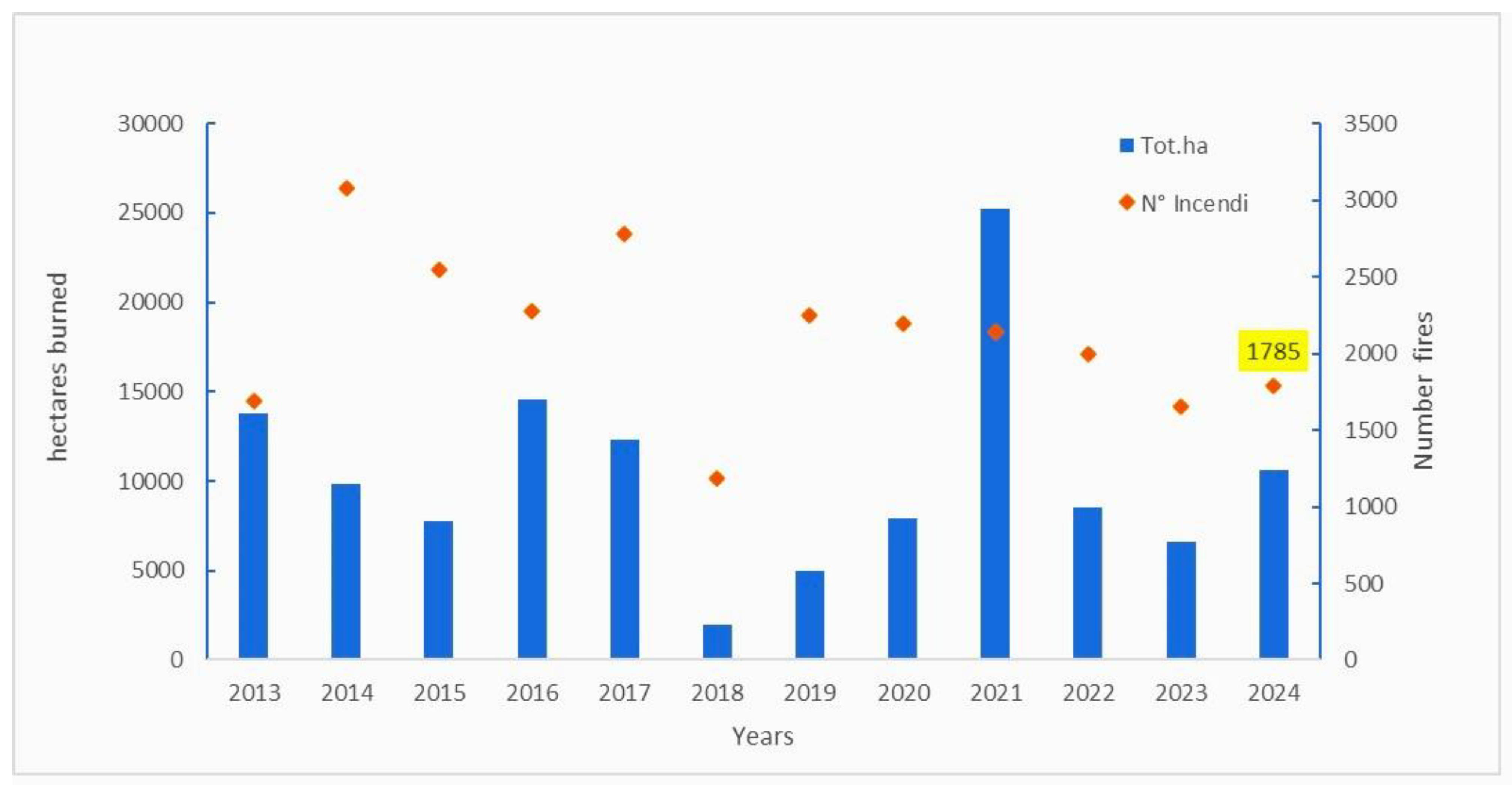
Figure 1. Surface trends and forest fires in Sardinia (2013–2024).
Fire 07 00409 g001
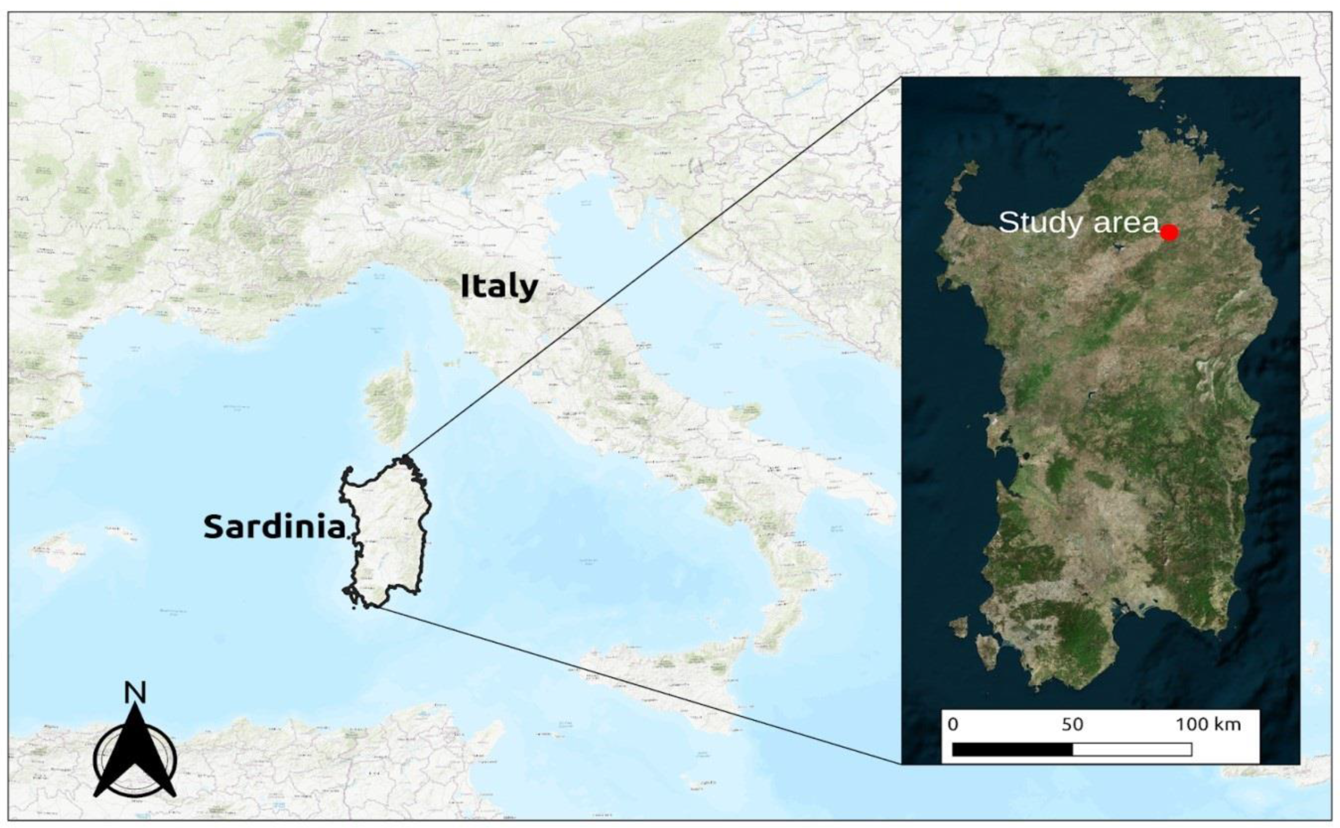
Figure 2. Study area localization in Italy and Sardinia (Credit ESRI World Topo and Bing Aerial).
Fire 07 00409 g002
Figure 3. General map of the Berchidda-Monti observatory and subdivision of the study areas according to their percentage of canopy cover (HCA 44%; LCA 22%; OA: 0%).
Fire 07 00409 g003
Scheme 1. Movable grazing exclusion grazing cages (1 m × 1 m).
Fire 07 00409 sch001
Scheme 2. Cages outside the tree canopy during sampling days.
Fire 07 00409 sch002
Figure 4. Differences in fuel biomass between grazed and ungrazed areas.
Fire 07 00409 g004
Figure 5. Percentage reduction comparing simulated scenarios in grazed areas.
Fire 07 00409 g005
Figure 6. Severity maps for the 18 simulation scenarios.
Fire 07 00409 g006
Figure 7. Flame length trends in the different fuel model scenarios.
Fire 07 00409 g007
Figure 8. Trend of the fireline intensity in the different fuel model scenarios.
Fire 07 00409 g008
Figure 9. Trend of the flame spread rate in the different fuel model scenarios.
Fire 07 00409 g009
Figure 10. Relationship between fuel bed height (h) and flame height (Hf) (measured from the base of the fuel bed) as a function of weighted leaf fuel moisture content (Mw). Retrieved from Rossa and Fernandes (2017) [56].
Fire 07 00409 g010
Figure 11. Reduction in the average FL, ROS, and FLI due to grazing.
Fire 07 00409 g011
Figure 12. Map of the MTT high-cover area simulation. The different colors refer to a different fuel model in the high cover case.
Fire 07 00409 g012
Table 1. Fuel models used in the simulation.
FMCodeFMNameFMCodeFMNameFMCodeFMName
GHW20Grazed high-density wet yearGHM26Grazed high-density median yearGHD32Grazed high-density dry year
UHW21Ugnrazed high-density wet yearUHM27Ugnrazed high-density median yearUHD33Ugnrazed high-density dry year
GLW22Grazed low-density wet yearGLM28Grazed low-density median yearGLD34Grazed low-density dry year
ULW23Unrazed low-density wet yearULM29Unrazed low-density median yearULD35Unrazed low-density dry year
GOW24Grazed open area wet yearGOM30Grazed open area median yearGOD36Grazed open area dry year
UOW25Ungrazed open area wet yearUOM31Ungrazed open area median yearUOD37Ungrazed open area dry year
Table 2. Parameters of fire behavior calculated for each fuel model (FL, ROS, FLI).
FMCodeFL MeanFL MaxFL MinROS MeanROS MaxROS MinFLI MeanFLI MaxFLI Min
mmmm/minm/minm/minkWm−1kWm−1kWm−1
Wet Year Fuel ConditionsGHW201.01.11.07.07.36.8281.2298.4275.7
UHW211.81.81.815.115.914.8897.1943.9882.0
GLW221.11.11.06.76.85.7298.3305.6256.3
ULW231.71.81.611.111.39.8860.3877.2762.1
GOW241.11.21.17.37.77.7335.4352.7307.2
UOW251.91.91.814.214.813.21038.81083.8965.2
Median Year Fuel ConditionsGHM261.41.41.39.510.19.3499.3528.0490.1
UHM272.02.01.916.016.815.71116.11173.71097.5
GLM281.51.51.49.19.37.9609.0623.2527.3
ULM291.81.81.79.19.28.0880.0897.7777.5
GOM301.51.51.410.010.59.2600.9630.1553.0
UOM312.12.12.015.015.713.91303.21359.41211.2
Dry Year Fuel ConditionsGHD321.31.31.39.19.68.9474.7474.7440.3
UHD331.81.81.714.214.913.9884.7931.5869.6
GLD341.41.41.38.78.97.5545.7558.5471.9
ULD351.71.71.610.410.69.2857.2874.4757.5
GOD361.41.41.39.510.08.8538.8565.1495.5
UOD371.91.91.813.313.912.41028.71074.0954.5
Table 3. Difference and reduction in FL, ROS, and FLI between grazed and ungrazed outputs.
FL MeanROS MeanFLI Mean
m%m/min%kWm−1%
GHW20-UHW21−0.7341.24−8.1453.82−615.9068.66
GLW22-ULW23−0.6738.56−4.4239.85−561.9565.32
GOW24-UOW25−0.7640.51−6.9148.70−703.4167.71
GHM26-UHM27−0.6030.77−6.4540.38−616.855.26
GLM28-ULM29−0.2715.63−0.07−0.77−271.0630.80
GOM30-UOM31−0.6329.92−5.0233.49−702.3653.89
GHD32-UHD33−0.4726.70−5.1036.04−436.0246.35
GLD34-ULD35−0.3318.76−1.6916.30−311.5036.34
GOD36-UOD37−0.4825.76−3.8028.51−489.9447.63
Table 4. Extension (in hectares) of the fires simulated in the area with high canopy cover.
Fuel ModelExtension of fire (ha)Reduction %
GHW201.425.9
UHW215.4
GHM262.560.9
UHM274.1
GHD322.2 45.8
UHD334.8
Disclaimer/Publisher’s Note: The statements, opinions and data contained in all publications are solely those of the individual author(s) and contributor(s) and not of MDPI and/or the editor(s). MDPI and/or the editor(s) disclaim responsibility for any injury to people or property resulting from any ideas, methods, instructions or products referred to in the content.