Abstract
This paper provides information about (a) 15 wildfire-related accidents that took place during 12 wildfires due to eruptive fire behavior in the 1982–2016 period and (b) six additional cases of “chimney effect” and “flame attachment” occurrence that caused no deaths or injuries, in the 2007–2019 period, in Greece. The work is based on (i) detailed documentation and reconstruction of wildfire behavior and spread, (ii) coupling of wildfire behavior with geospatial data and analysis, (iii) location information and field evidence for firefighter and citizen fatalities, and (iv) events surrounding those fatal accidents. These are matched with corresponding weather and fuel information, creating a rather complete picture of the conditions that entail a great risk to firefighters and citizens. The objectives of our effort are (a) to identify the common elements present in these cases and extract conclusions about the common denominators that may lead to fatal or near-fatal firefighter accidents, (b) to discuss how the findings compare with similar accidents in other countries, and (c) to develop clear messages for firefighters and citizens to help improve their safety.
1. Introduction
Wildfires are a natural hazard as they cause significant environmental damage, often destroy properties and infrastructure, and sometimes even cause injuries and fatalities. The latter refers to firefighters, who operate in an inherently dangerous environment, but also to civilians who are caught by surprise as the phenomenon evolves in unexpected ways.
Historically, fatal accidents have received significant attention as it is obviously important to understand the conditions and circumstances that have led to the disaster and learn from each event to improve future responses. They are addressed either statistically [1,2,3,4] or through detailed analysis of specific wildfire fatality case studies [5,6,7,8,9,10,11,12,13]. Comparisons between accidents that have occurred due to eruptive fire behavior in different sites, countries, or continents (i.e., Europe and U.S.A.) reveal similarities and show the universality of the phenomenon and its “recuring nature”. For example, there are similarities between different accidents such as the Palasca fire [14] and the Kornati fire [8].
Practical firefighter training needs to make the trainees aware of the risks involved in their profession, to identify the elements affecting those risks, and to teach trainees how to identify early signs, react, choose fire suppression tactics and make judicious operational decisions. Central to such training are the works of Wilson [15], who identified four major common denominators of fire behavior regarding fatal and near-fatal fires, and Mangan [1], who identified four additional risk categories for wildland firefighter fatalities “for the 21st century”. Wilson [15] stated that such events often occur when firefighters are not on alert especially in the case of “relatively small fires or deceptively quiet areas of large fires”, when fires move very fast “in relatively light fuels, such as grass, herbs, and light brush”, and when the direction of fire spread changes abruptly and surprises firefighters, namely “when there is an unexpected shift in wind direction or wind speed” and “when fire responds to topographic conditions and runs uphill”.
On the other hand, Mangan’s [1] new common denominators are related to the working environment (aerial firefighting, vehicle accidents, physical stress and health problems, and other risks such as falling snags, rolling rocks, downed power lines, and lightning strikes). These new categories appear dominant in his analysis, but he also points out that more than 20% of the fatalities during wildland firefighting operations continue to occur in burn overs. Training related to the original four denominators proposed by Wilson [15], which have been stressed in currently used firefighting handbooks, and the adjustment of fire suppression tactics are the likely reasons behind this relatively low percentage.
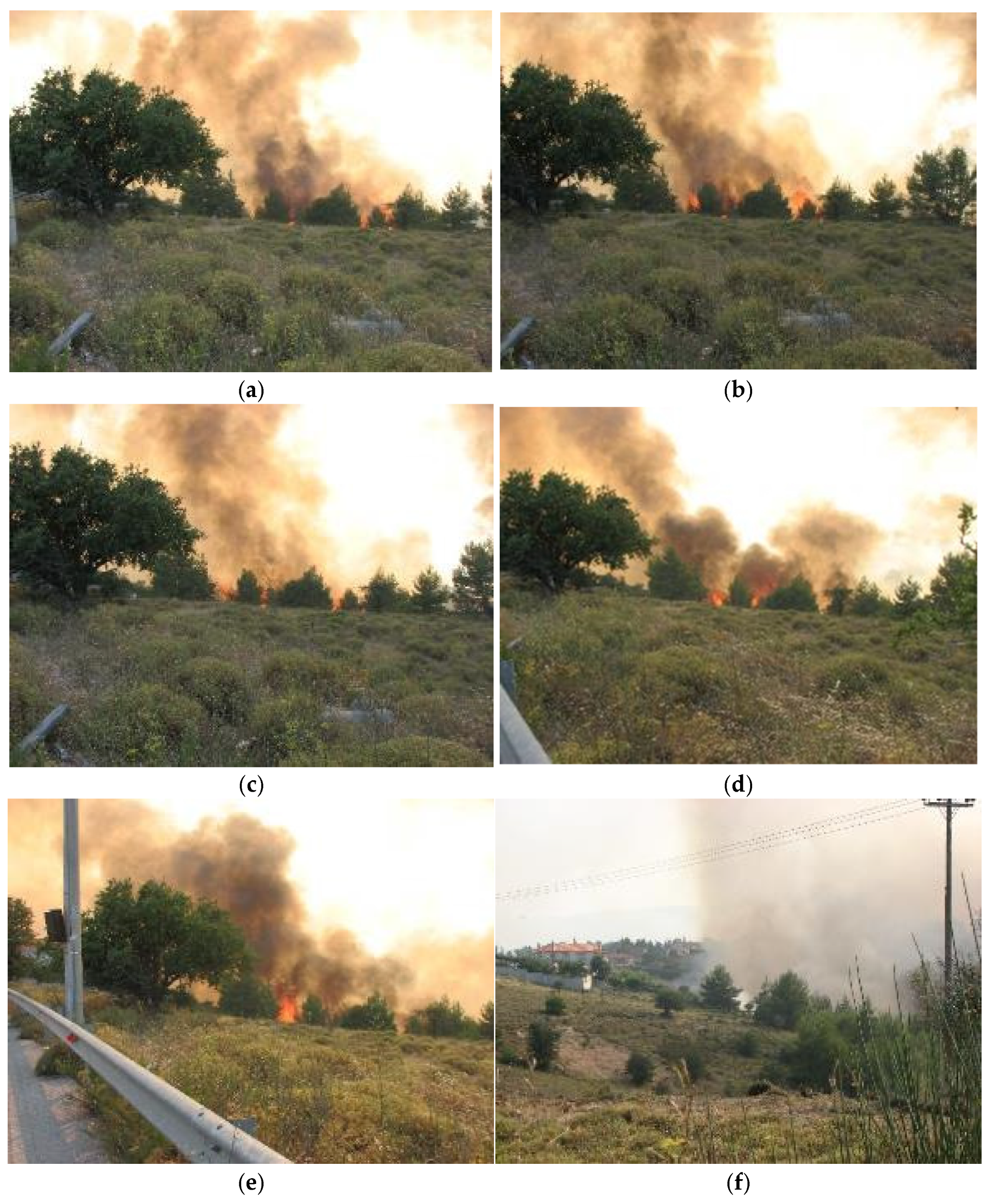
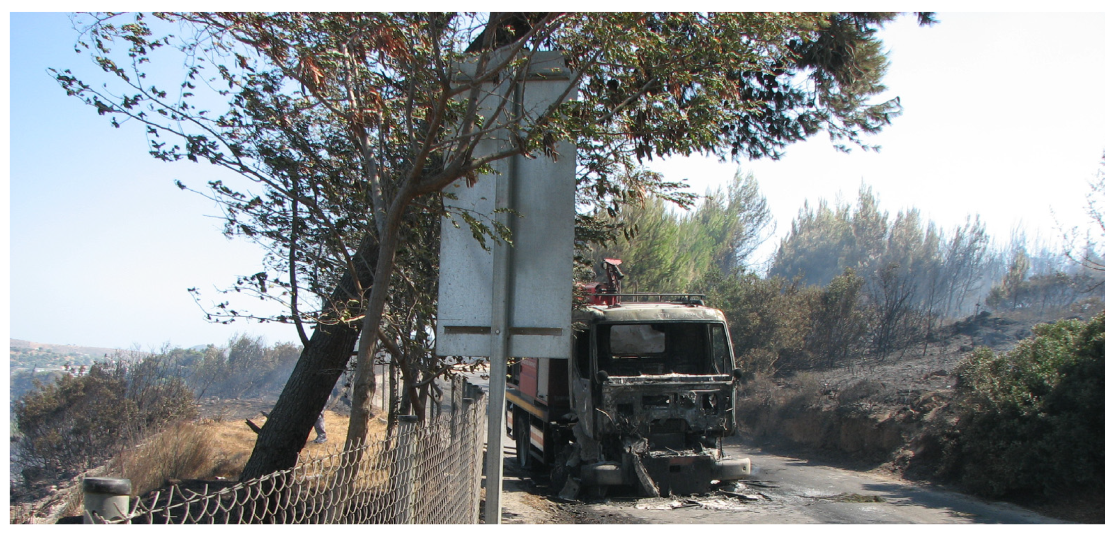
Given the importance of the subject, relatively little scientific literature is available to support either the modelling [16,17,18,19,20,21] or prediction of the occurrence of such disasters [22], although it is crucial for firefighters and citizens to be able to recognize the locations and conditions that may lead to dangerous, often eruptive, fire behavior as early as possible. In some cases, firefighters are able to foresee the occurrence of the phenomenon (Figure 1 and Figure 2), take safety measures, and adapt their tactics appropriately; meanwhile, in others, firefighters or citizens do not recognize the threat (Figure 3, Figure 4 and Figure 5) until it is too late. Moreover, from a firefighter’s perspective, conditions that may lead to dangerous fire growth do not necessarily preclude successful fire suppression operations [23].
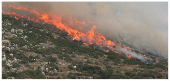
Figure 1.
An example of flame attachment and fire spread across a 23-degree slope (42% grade). Four firefighters stand close to the heel of that fire finger (at bottom right), having assessed the potential and risk of fire on time (photograph: Miltiadis Athanasiou).
Figure 1.
An example of flame attachment and fire spread across a 23-degree slope (42% grade). Four firefighters stand close to the heel of that fire finger (at bottom right), having assessed the potential and risk of fire on time (photograph: Miltiadis Athanasiou).
Studies of wildfire fatalities need to explain the events surrounding the accident, provide detailed location information, bring together and analyze available evidence regarding the accident, and use geospatial and environmental data. Fire, as well as human behavior, should be considered in detail. Through this, the accident can be reconstructed, and being fully documented, the true circumstances, errors and unfortunate choices can be explained, providing important lessons. Sharing knowledge gained from past accidents with firefighters and the general public, helping them to avoid misconceptions or erroneous concepts, and identifying where the landscape variables align to increase the likelihood of a fatal burn over [23] can reduce the chances of such accidents being repeated [24].
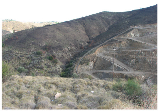
Figure 2.
Eruptive fire behavior took place along this ravine. The sky was cloudy during the occurrence and evolution of the phenomenon which was further amplified by the smaller ravines in the area. The firefighters quickly identified the danger (photograph: Miltiadis Athanasiou).
Figure 2.
Eruptive fire behavior took place along this ravine. The sky was cloudy during the occurrence and evolution of the phenomenon which was further amplified by the smaller ravines in the area. The firefighters quickly identified the danger (photograph: Miltiadis Athanasiou).
Greece, being a Mediterranean country with a beautiful but flammable agricultural and forest landscape in the summer, has not been spared from such disasters. A significant number of deadly fires have occurred since 1977, involving firefighters, civilians or both [2]; this actually follows an increasing trend, despite significant improvements in fire suppression capabilities in recent years.
Some of these fires have been the subject of previously published research [25,26] leading to the conclusion that “the causes of each fatal accident are not unique to each case”, and that “they have been identified before in some other place and time, and they fall into broad categories for which warnings have been established in international literature” [25]. However, as the occurrence of fatalities increases, interest in the conditions that lead to them has become extremely high.
In Greece, the systematic observation, recording and measurement of wildfire behavior started in 2007 [27,28] and continues until today. The procedures followed, both in the field and in the office, have been described in [28,29], providing information on different landscapes, fuels, weather conditions, wildfire behavior and types, namely surface fires, which burn surface fuels such as litter, downed woody debris, and low-level living plants [30,31], or crown fires, which spread through the forest canopy, usually in conjunction with surface fuels [32,33].
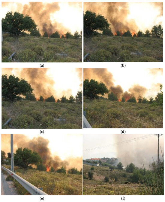
Figure 3.
A series of snapshots at (a) 0 s, (b) 2 s, (c) 4 s (d) 32 s and (e) 40 s of video footage of eruptive fire potential that was recorded on a 22% grade gully, mainly covered by Sarcopoterium spinosum and Cistus creticus, despite two helicopter bucket drops and ground firefighting. (f) The slope seen from a different angle (footage and photograph: Miltiadis Athanasiou). Weather conditions: T = 28 °C, RH = 45% and general wind speed at eye level = 10 km·h−1. The eruptive fire behavior potential had been forecasted by the first author, and citizens intending to fight the fire were told to watch out and not to approach the fire from above. The citizens ignored this advice and did not recognize the threat, but fortunately there were no injuries.
During this time, there were either surface [30] or active crown [32] fires, characterized by extreme behavior that caused deaths or jeopardized lives. Having identified, through a general overview, topography as a major contributor to extreme wildfire behavior, twelve fatal and six near-fatal fires were selected. These eighteen cases for which detailed stories have been developed are associated with eruptive fire behavior in canyons, gorges, gullies, draws, ravines, and steep slopes. Among the causes and contributing factors that aligned during their occurrence, the crucial common denominator was topography.
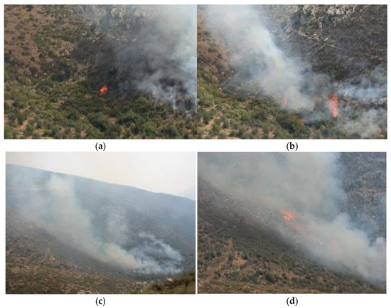
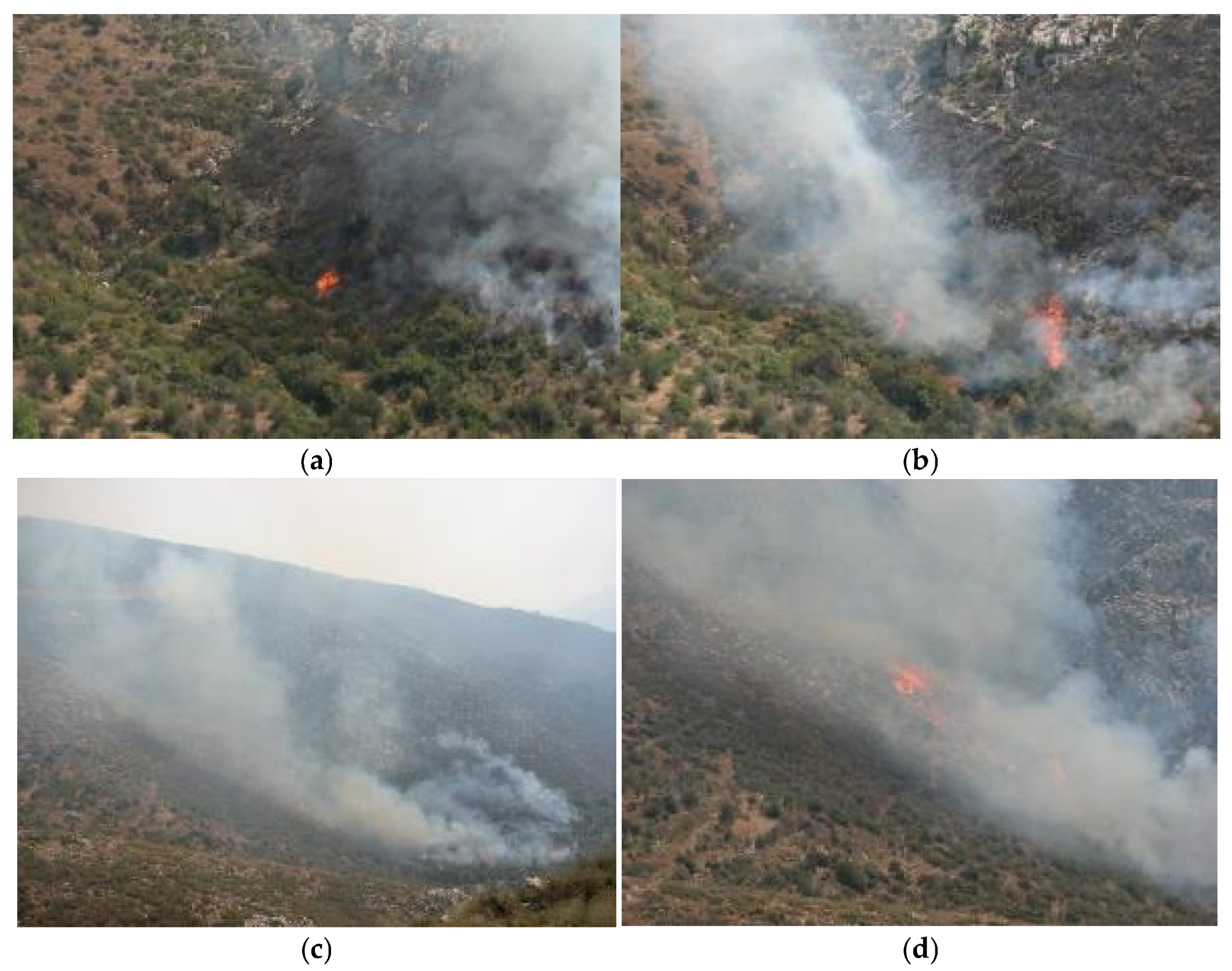
Figure 4.
A series of snapshots in two subsets: The first subset consists of snapshots at (a) 0 s and (b) 11 min and 34 s, with a downslope rate of fire spread (ROS) ranging from 0.1 to 0.4 m·min−1. The second subset consists of snapshots at (c) 24 min and 20 s and (d) 25 min and 24 s, with an upslope ROS equal to 150 m·min−1 just after the occurrence of eruptive fire behavior recorded on a 119% grade box canyon, mainly covered by phrygana, grass and shrubs. Weather conditions: T = 43 °C, RH = 29%, calm. The first author forecasted the eruptive fire behavior and citizens who tried to approach and fight the fire from above were told to watch out. They stopped in time, and there were therefore no injuries (photographs: Miltiadis Athanasiou).
Several authors have described the influence of topography (steep slopes, ridges, ravines and canyons) on fire behavior [34,35,36,37]. Canyons may act as chimneys [35], occasionally creating a chimney effect that “induces a sudden and very fast fire propagation” [17]. The term “fire eruption” has been suggested to describe the blow-up and dynamic increase in the rate of fire spread (ROS, m·min−1) [16] that occurs on steep slopes or in canyons in a very short space of time. According to [18], “the occurrence of a fire eruption requires only the existence of a sufficiently long or steep slope covered by continuous vegetation, without the requirement of any other special effect like the occurrence of a sudden wind gust, the passage of a front or the existence of a thermal belt”.
The chimney (Venturi) effect [38], along with the Coanda effect [39], which causes the buoyant plume to attach to the bed of the canyon, establish flame attachment [7,40,41]; this eventually results in the enhanced preheating and pyrolysis of the fuel above the fire and leads to the acceleration of fire spread (Figure 1 and Figure 4).
The rapidity of the transition from a relatively low-intensity, slow-spreading fire to a high-intensity, fast-moving fire is associated with the flame attachment phenomenon [41]. Flame attachment plays a key role in the occurrence of eruptive fire behavior [42] in landforms that satisfy the necessary geometric prerequisites [41], while the fuel structure influences the behavior of fire also [43].
The present work is a synoptic presentation of eighteen thoroughly analyzed and carefully documented wildfires in Greece that exhibited eruptive fire behavior and resulted in fatalities or near misses, putting an emphasis on the effect of topography, which is considered to be very complex in most of the country.
Other serious wildfire accidents that were not solely influenced by topography, such as (a) the fatal entrapment of August 2007 in Artemida, Greece [10], which was associated with a plume and profuse spotting, and (b) the deadly wildfire of 23 July 2018 in Northeastern Attica, Greece [13], which was caused by gale-force wind that resulted in an erratic spread with very fast downslope fire runs, a scattered occurrence of independent crown fire [32], and impressive fire growth, were excluded from this analysis.
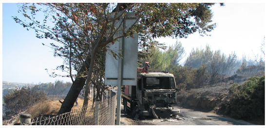
Figure 5.
Wind and slope aligned, and the fire suddenly accelerated in shrubs and young pine trees. Volunteer firefighters abandoned the fire truck, which burned. Fortunately, there were no injuries (photograph: Miltiadis Athanasiou).
Figure 5.
Wind and slope aligned, and the fire suddenly accelerated in shrubs and young pine trees. Volunteer firefighters abandoned the fire truck, which burned. Fortunately, there were no injuries (photograph: Miltiadis Athanasiou).
2. Materials and Methods
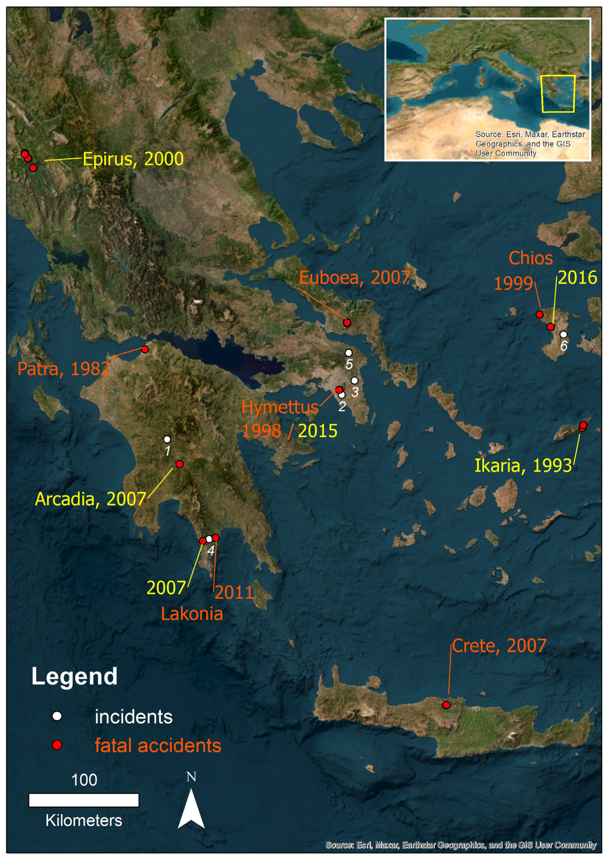
Twelve (12) wildfires with fatalities and six (6) incidents with potential for fatalities or near misses from the periods 1982–2016 and 2007–2019, respectively, were selected (Figure 6).
In two of the twelve (12) fatal wildfires, fatalities occurred in more than one location, bringing the total number of fatality sites to fifteen (15). The common attribute of all these events was that their behavior had been significantly influenced by topography. The dataset that was developed consists of
- (a)
- Twelve wildfires that caused 46 fatalities (13 firefighters and 33 citizens either on site or later in the hospital) and injured 6 people (2 firefighters and 4 citizens) in 15 accident sites
- (b)
- Six cases of “chimney effect” and “flame attachment” occurrence that caused no deaths or injuries and were recorded in the field.
For the cases examined here, the information regarding fire behavior and the wildfire stories was sourced from the following:
- (a)
- living members of fire engine or hand crews and professional and volunteer firefighters who had worked on those fires and were interviewed, either at the accident site during later visits or elsewhere;
- (b)
- interviews with locals at the accident sites;
- (c)
- data from our field measurements and archives;
- (d)
- data, photos, video footage and information either reported by public agencies or published by citizens via mass and social media.
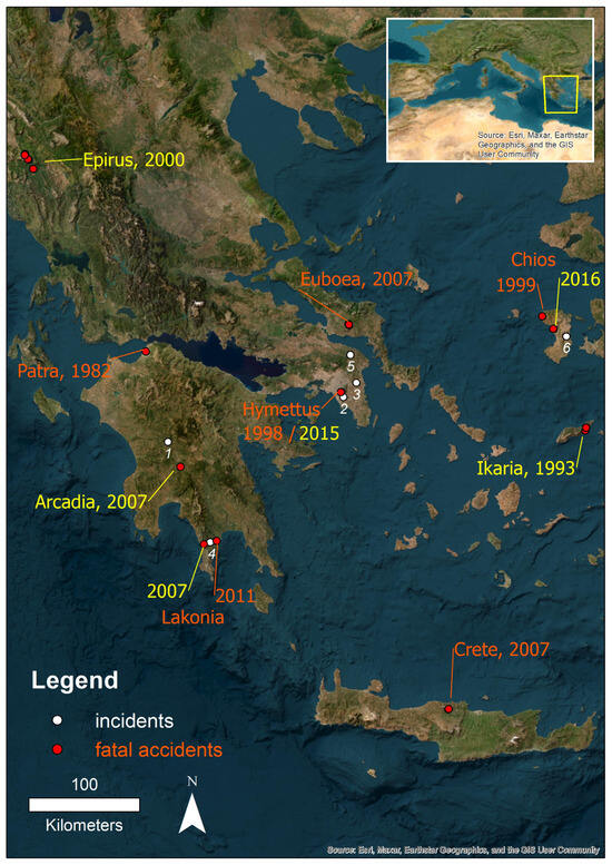
Figure 6.
Twelve (12) wildfire-related accidents that took place in 15 locations. Yellow labels are cases in which no firefighters were among the victims. In the case of Euboea (2007), two (2) of the five victims were seasonal firefighters who were off duty during the accident. White labels (1–6) are the six (6) recorded cases (incidents) of eruptive fire behavior that did not cause injuries or deaths.
We found the exact locations of the bodies of the victims and/or injured people and pinpointed them on maps (e.g., Figure 7, Figure 8 and Figure 9) using the ArcGIS 9.3 Geographic Information System (GIS) software by ESRI corporation (Redlands, CA, USA). For each victim and/or injured person and for each point/location, we calculated the following metrics using a Digital Elevation Model (DEM) under the Creative Commons Attribution 3.0 License (pixel size = 5 m, http://gis.ktimanet.gr, accessed on 26 May 2022) in ArcGIS 9.3 software:
- (a)
- The shortest ground distance (m), which is the shortest true distance over the surface, considering the topography of the area, between the body or injured person and the closest canyon/gorge bed (ds_cg, m);
- (b)
- The maximum grade along the axis (bed) of the closest canyon/gorge (cg_mxgr, %);
- (c)
- The mean grade of the ground along which the fire finger of interest had spread (either along the closest canyon/gorge bed or across a side slope) (fs_mngr, %);
- (d)
- The maximum grade of the ground along which the fire finger of interest had spread, (either along the closest canyon/gorge bed or across a side slope) (fs_mxgr, %);
- (e)
- The shortest ground distance between the body or injured person and the unburned vegetation (ds_vg, m);
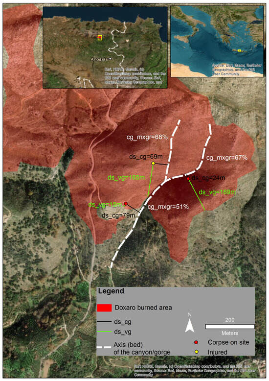
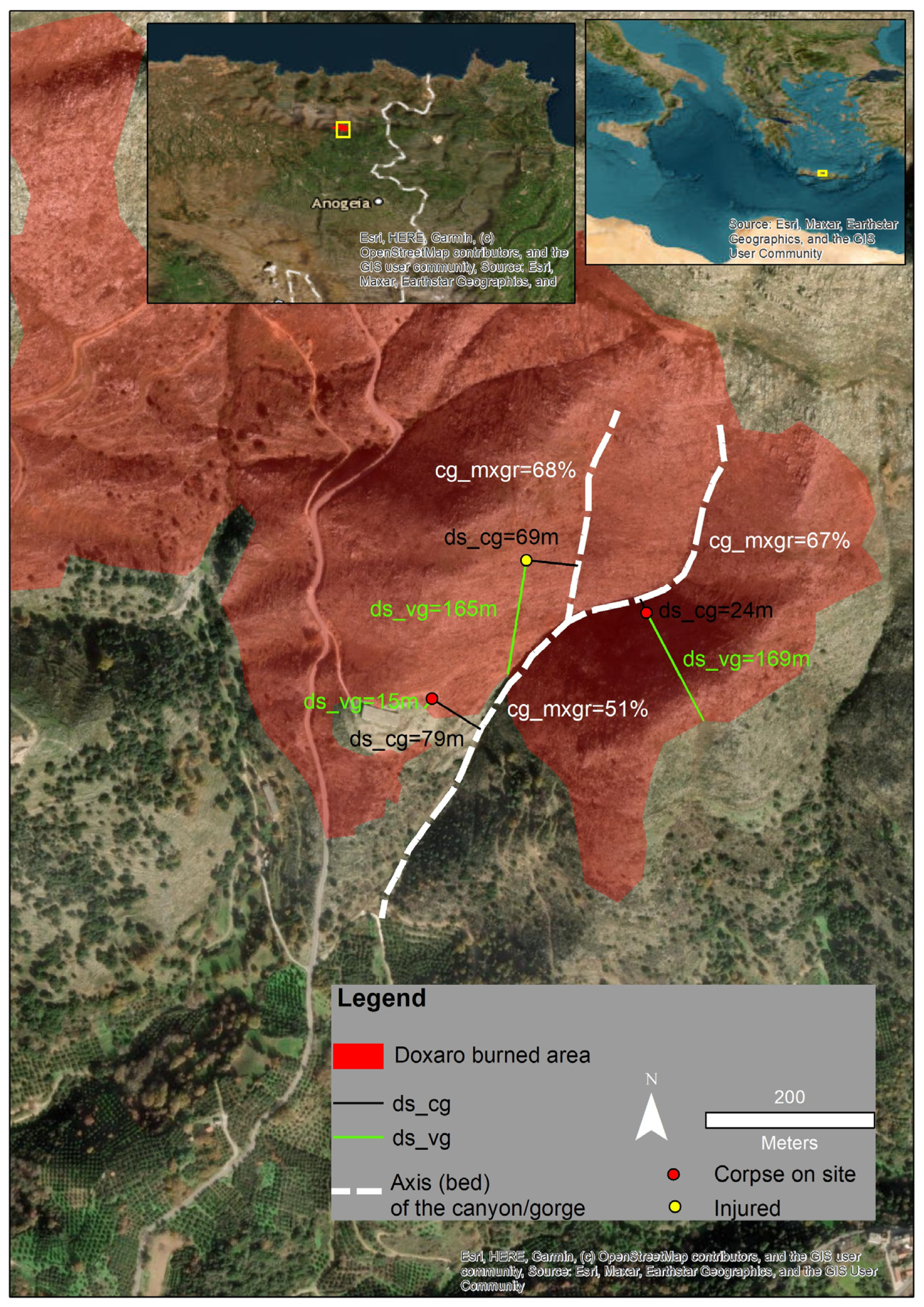
Figure 7.
Calculations of ds_cg and ds_vg for corpses found on site (red dots) and the injured firefighter (yellow dot) (Doxaro accident in Crete in 2007, see Figure 6). The maximum grade values of the axes (beds) of three parts of the canyon (cg_mxgr, %) are presented also.
Figure 7.
Calculations of ds_cg and ds_vg for corpses found on site (red dots) and the injured firefighter (yellow dot) (Doxaro accident in Crete in 2007, see Figure 6). The maximum grade values of the axes (beds) of three parts of the canyon (cg_mxgr, %) are presented also.
- (f)
- The distance along road or trail between the body or injured person and the closest wildfire-resilient structure (ds_rstr, m). This was only calculated for citizens.
Regarding (b), (c) and (d), the grade (rise) refers to the tangent of the angle of any physical feature (gorge/canyon bed or other ground surface, e.g., a slope) to the horizontal direction, multiplied by 100.
We utilized valuable information from field observations and firsthand testimonies, and we applied specific procedures both in the field and in the office to accurately calculate the rate of fire spread (ROS, m∙min−1) [28,29]. For all photographs and video footage, we identified the observers’ positions, the times of the shots, and the horizontal azimuths of the observations. Thus, the sequential locations of the wildfire perimeter were pinpointed on the map [40] using GIS software, wildfire isochrones were drawn, ROS values were calculated, and the spread and growth of the wildfire were reconstructed.
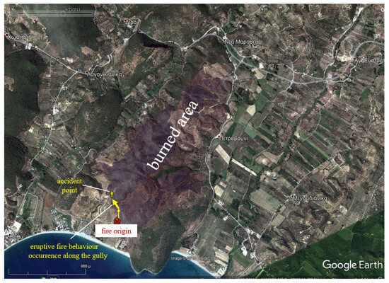
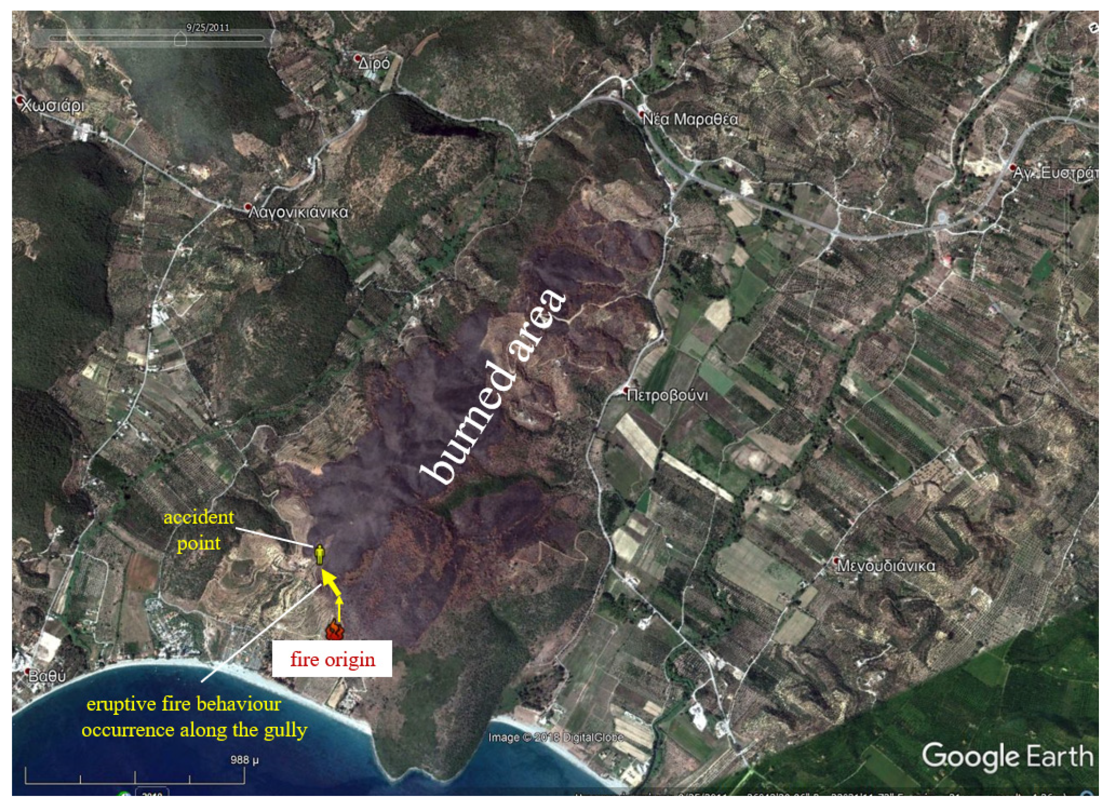
Figure 8.
The analysis of the accident which took place in Lakonia in 2011 (see Figure 6). showed that immediately after the occurrence of eruptive fire behavior, the head officer of the local fire service ran uphill to escape but did not reach safety, falling just 13 m short. His body was found 28 m from the unburned vegetation and 30 m from the bed of the gully (thick yellow arrow) along which eruptive fire behavior took place (basemap: Google Earth image). The thin yellow arrow represents the spread of the flank of the fire, from its origin to the mouth of the gully.
Further information was added to the dataset regarding the vegetation (forest fuels) of the accident and incident sites. We estimated the fine dead fuel moisture content (FDFMC, %) from (a) air temperature and relative humidity measurements, (b) the month and time of day of the accident or incident, (c) the slope and aspect of the fire spread location and (d) the shading of surface fuels by utilizing Rothermel’s [44] methodology.
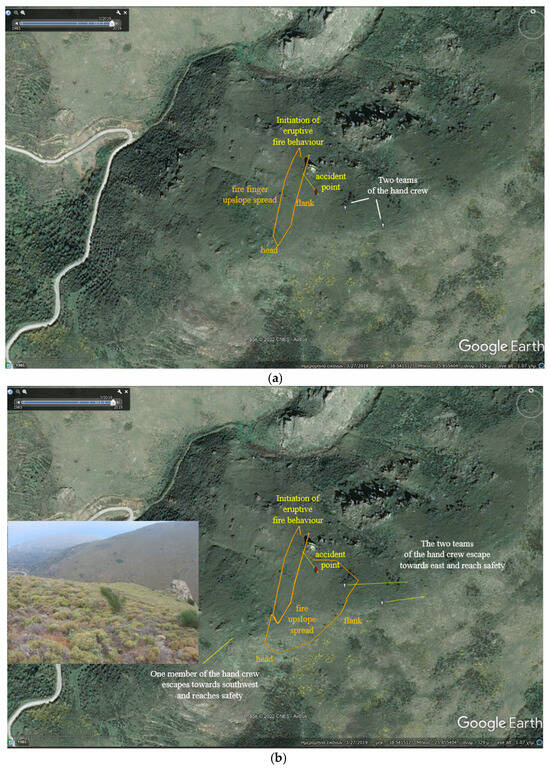
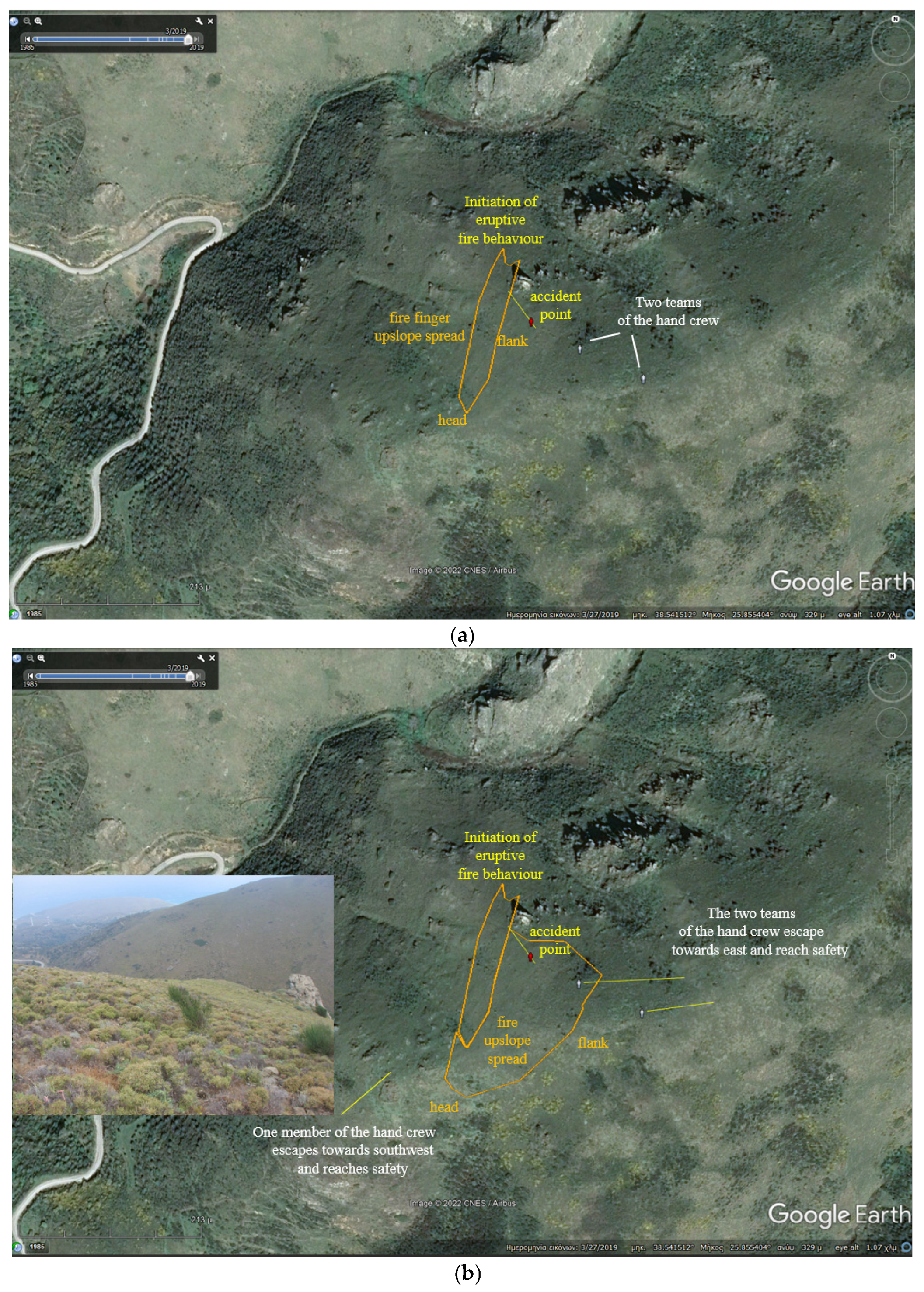
Figure 9.
(a) A fire service officer and a seasonal firefighter tried to help a female seasonal firefighter who had collapsed for unclear reasons at the accident point after the eruption of fire (Chios accident in 1999, see Figure 6). (b) They were soon approached by the high-intensity east flank of the fire finger (narrow orange polygon), which was spreading upslope at a rate of slightly less than 240 m min−1. The rest of the hand crew members escaped and reached safety. This photograph of the northwest and downhill area was taken by the first author, in 2018, from the location of the western hand crew team (basemap: Google Earth image).
For the cases of known ROS, that is, the accidents and incidents for which the ROS of eruptive fire behavior could be calculated, the surface fuel load (kg∙m−2) was estimated also. The necessary data for these calculations were derived from Greek fuel models that describe evergreen sclerophyllous fuel types, phrygana and grass [27,45]. Phrygana are small xeric shrubs that are up to 0.5 m height; they are flashy fuels and have been the cause of many firefighting accidents in Greece. Regarding the occurrence of eruptive fire behavior, it was noted whether the wind had triggered the initiation of the fire eruption or influenced its eruptive behavior. Moreover, the wind speed values were either obtained via on-site measurements at eye level (midflame wind speed values [44]) using a hand-held device or estimated from appropriately converted wind speed values that were initially measured at 10 m.
3. Results
The above-mentioned topographic, fuel and weather data were matched with documented and measured wildfire behavior and are presented in Table 1, Table 2, Table 3 and Table 4.

Table 1.
Wildfire accidents, associated with eruptive fire behavior (red spots in Figure 6). 1 Two accident locations. 2 Three accident locations.
Table 1.
Wildfire accidents, associated with eruptive fire behavior (red spots in Figure 6). 1 Two accident locations. 2 Three accident locations.
| Fatalities | |||||||||
|---|---|---|---|---|---|---|---|---|---|
| Case. Wildfire (Accident Site), Year | Forest Fuels | fs_mngr-fs_mxgr (%) | Wind Influence | Fire Type | ROS (m·min−1) | Corpses on Site | Died in the Hospital | Injured | Victims |
| 1. Patra (Aroi), 1982 | Reeds, grass and phrygana | 48–56 | N/A | surface | N/A | 0 | 1 | 0 | Firefighter |
| 2. Ikaria (south) 1, 1993 | Tall shrubs | 20–68 | N/A | N/A | N/A | 5 | 0 | 0 | Citizens |
| 2. Ikaria (north) 1, 1993 | Tall shrubs | 21–72 | N/A | N/A | N/A | 7 | 0 | 0 | Citizens |
| 3. Hymettus, 1998 | Pine forest with phrygana understory | 25–66 | no | active crown | N/A | 4 | 0 | 0 | Firefighters |
| 4. Chios (Melanios), 1999 | Phrygana | 43–49 | yes | surface | 240 | 1 | 1 | 1 | Firefighters |
| 5. Epirus, (Agia Marina) 2, 2000 | Tall shrubs and oaks | 12–78 | yes | active crown | N/A | 3 | 0 | 0 | Citizens |
| 5. Epirus, (Lavdani) 2, 2000 | Tall shrubs and oaks | 16–46 | yes | active crown | N/A | 3 | 0 | 0 | Citizens |
| 5. Epirus, (Rizo) 2, 2000 | Tall shrubs and oaks | 44–84 | yes | active crown | N/A | 1 | 0 | 0 | Citizens |
| 6. Crete (Doxaro), 2007 | Phrygana | 38–67 | no | surface | N/A | 3 | 0 | 1 | Firefighters |
| 7. Lakonia (Neo Oitylo), 2007 | Phrygana and grass | 11–34 | no | surface | N/A | 5 | 0 | 0 | Citizens |
| 8. Arcadia (Leontari), 2007 | Tall shrubs and oaks | 20–43 | yes | active crown | N/A | 4 | 0 | 0 | Citizens |
| 9. Euboea (Mistros), 2007 | Pine forest | 12–101 | yes | active crown | N/A | 4 | 1 | 1 | Citizens Firefighters |
| 10. Lakonia (Vathy), 2011 | Phrygana and tall shrubs | 21–36 | yes | surface | 200 | 1 | 0 | 0 | Firefighter |
| 11. Hymettus, 2015 | Phrygana and young pines | 28–66 | N/A | surface | N/A | 1 | 0 | 0 | Citizen |
| 12. Chios (Sidirounda), 2016 | Phrygana | 19–55 | yes | surface | N/A | 0 | 1 | 3 | Citizens |
| 42 | 4 | 6 | |||||||
Note: “N/A” means “Information is not available”, meaning either it was missing altogether (e.g., influence of wind on fire behavior or fire type) or could not be determined due to a lack of necessary data (e.g., ROS).
The ground distances from gorges (ds_cg), unburned vegetation (ds_vg) and resilient structures (ds_rstr), along with the grade values of fire paths (fs_mngr, fs_mxgr) and gorge beds (cg_mxgr), were calculated in GIS software for each victim or injured person and found in distinct points at each accident site. For example, in the Doxaro accident (Table 1, case 6, Figure 7), the bodies and the injured firefighter were found in three separate locations; therefore, distinct fs_mngr and fs_mxgr values, as well as distinct ground distance (ds_cg and ds_vg) values, were calculated. One firefighter perished about 79 m away from the gorge bed and only 15 m from the unburned vegetation. Two perished only 24 m away from the gorge along which eruptive fire behavior took place and about 169 m from the unburned vegetation; meanwhile, the injured firefighter was found about 69 m from the gorge bed and 165 m from the unburned vegetation. Grade values (cg_mxgr, fs_mngr and fs_mxgr) were calculated for all fifty-two (52) cases, and the descriptive statistics of those metrics are presented in Table 2.

Table 2.
Descriptive statistics of ground distances and grade values for the 12 accidents.
Table 2.
Descriptive statistics of ground distances and grade values for the 12 accidents.
| ds_cg (m) | cg_mxgr (%) | fs_mngr (%) | fs_mxgr (%) | ds_vg (m) | ds_rstr (m) | |
|---|---|---|---|---|---|---|
| Mean | 68 | 58 | 24 | 59 | 1261 | 443 |
| Standard Error | 9 | 2 | 2 | 3 | 337 | 71 |
| Median | 34 | 55 | 21 | 64 | 226 | 221 |
| Mode | 30 | 74 | 20 | 72 | 226 | 965 |
| Standard Deviation | 64 | 16 | 11 | 19 | 2106 | 406 |
| Minimum | 2 | 26 | 11 | 26 | 15 | 4 |
| Maximum | 220 | 101 | 59 | 101 | 7066 | 1562 |
| Ν | 52 | 52 | 52 | 52 | 39 | 33 |
During the documentation of these 12 wildfire accidents, even slight differences in the metrics that were processed for the development of Table 2, such as those related to the spread of fire (namely fs_mngr and fs_mxgr) in the Ikaria, Epirus, Doxaro, Mistros and other accidents, were taken into account. For example, in the Neo Oitylo accident (Table 1, case 7), the ground distances between the bodies and the gorge bed (ds_cg), the unburned vegetation (ds_vg) and the stone-built wildfire-resilient hotel (ds_rstr) varied from 210 to 220, 186 to 191, and 103 to 117 m, respectively.

Table 3.
Six wildfire incidents, associated with eruptive fire behavior (six white spots in Figure 6).
Table 3.
Six wildfire incidents, associated with eruptive fire behavior (six white spots in Figure 6).
| Wildfire (Incident Site), Year | Forest Fuels | Wind Influence (Figure) | Fire Type | FDFMC (%) fs_mngr (%) ROS (m·min−1) |
|---|---|---|---|---|
| 1. Arcadia (Maratha), 2007 | Phrygana, grass, and shrubs | No (4) | surface | 5-119-150 |
| 2. Hymettus, 2009 | Phrygana and low shrubs | No (10a) | surface | 5-54-N/A |
| 3. NE Attica (Dioni), 2009 | Low shrubs and young pine trees | Yes (5) | surface | 8-100-N/A |
| 4. Lakonia (Chosiario), 2012 | Phrygana and low shrubs | Yes (10b) | surface | 3-45-N/A |
| 5. Attica (Kalamos), 2017 | Phrygana | Yes (3) | surface | 9-22-N/A |
| 6. Chios (Korakaris), 2019 | Phrygana, tall shrubs and grass | No (2) | surface | 12-36-300 |
Cases in which the ROS is known for eruptive fire behavior during accidents or incidents are presented in Table 4, along with additional information about the estimated surface fuel load (kg∙m−2) and FDFMC (%).

Table 4.
Accidents (A) and incidents (I) for which the ROS was calculated (RH: Relative Humidity, T: Temperature).
Table 4.
Accidents (A) and incidents (I) for which the ROS was calculated (RH: Relative Humidity, T: Temperature).
| A/I | Year | Wind Influence | Eye-Level Wind Speed (km/h) | RH (%) | T (°C) | fs_mngr-fs_mxgr (%) | Aspect of the Location | Forest Fuels (Surface Fuel Load, kg∙m−2)- FDFMC (%) | ROS (m·min−1) |
|---|---|---|---|---|---|---|---|---|---|
| Chios (Melanios)-A | 1999 | Yes | 25 | N/A | N/A | 43–49 | N | Phrygana (0.57)-N/A | 240 |
| Arcadia (Maratha)-I | 2007 | No | 0 | 29 | 43 | 119–142 | S | Phrygana, grass, and shrubs (1.42)-5 | 150 |
| Vathy, Peloponnese-A | 2011 | Yes | 15 | 40 | 33 | 21–36 | E | Phrygana and tall shrubs (2.57)-8 | 200 |
| Hymettus-A | 2015 | No | 35 | 31 | 31 | 25–67 | W | Phrygana and young pines (1.23)-6 | 150 |
| Hymettus-A | 2015 | No | 35 | 31 | 31 | 27–133 | W | Phrygana and young pines (1.23)-6 | 130 |
| Chios (Korakaris)-I | 2019 | No | 25 | 57 | 25 | 36–53 | E | Phrygana, tall shrubs and grass (1.90)-12 | 300 |
Note: N: North, S: South, E: East and W: West
4. Discussion—Conclusions
The common and crucial denominator of the twelve fatal fires presented in this paper was topography; in other words, this is “fire behaviour mostly driven by either canyons, gorges, gullies, draws, ravines or steep slopes”. Nevertheless, in some of those 12 cases, the eruptive fire behavior aligned with other contributing factors, conditions, events and decisions made by humans.
The accidents in Aroi, Melanios, Doxaro, Neo Oitylo, Hymettus (2015) and Sidirounda (Table 1, cases 1, 4, 6, 7, 11 and 12, respectively) occurred in relatively light and flash fuels (mostly phrygana), while the Vathy accident (Table 1, case 10) was a clear case of a “small” and deceptively “quiet” fire (Figure 8).
During the Melanios and Sidirounda accidents, wind aligned with topography, while in the Neo Oitylo, Leontari and Sidirounda accidents, citizens perished due to a lack of knowledge and incorrect decisions.
Increasing awareness and consequently reducing the risk of wildfires and accidents of this type require the dissemination of “clear messages” to firefighters and citizens, sharing knowledge gained from past accidents and incidents, and providing them with specific knowledge regarding where the landscape variables tend to occasionally align and increase the likelihood of fatal burn overs. Revealing similarities among accidents [24] that have occurred around the globe is an important and interesting part of the educational process and “lessons learned” approach.
The Mistros accident (Table 1, case 9) demonstrated an obvious similarity with the South Canyon accident on Storm King Mountain [6] and the Mann Gulch accident [5], with regard to spotting. In the case of the Mistros accident, the victims had entered a narrow valley. Shortly after that, firebrands from the fire, which was spreading downhill, landed at the mouth of the valley and started spot fires that blocked their exit. After entrapment, they were chased by rapidly uphill-spreading flames of an active crown fire of high intensity and eruptive behavior. In the Mann Gulch and the South Canyon accidents, the fire also spread downslope on steep terrain and a canyon, firebrands landed at the bottom of the slope and canyon, spot fires developed, and the fire erupted and spread rapidly uphill, killing firefighters.
Another similarity was found between the South Canyon accident and the Maratha incident (Table 3, case 1 and Figure 4), the latter being a case of recorded and measured eruptive fire behavior in a box canyon. In the South Canyon accident, the average downslope rate of fire spread during most of the fire was 0.11 m·min−1, whereas during the eruption that preceded the accident, it was estimated that the ROS values were in the order of 104 m·min−1 [19]. In the Maratha incident, the downslope fire ROS varied from 0.1 to 0.4 m·min−1 [Figure 4a,b]; this was followed by flame attachment, eruptive fire behavior, and a rapid upslope fire run of 150 m·min−1 [Figure 4c,d].
It is well known that when the slope is perpendicular to the direction of the wind, the fire spread is in the direction of the resultant wind and slope vectors. As it spreads downwind, its flank (lateral spread) is drawn into the “mouth” of the canyon and spreads within it, roughly perpendicular to the direction of the prevailing wind [21,46]; this is a clear demonstration of the so-called “chimney effect” [19]. This kind of fire spread pattern killed five (5) people in the Hymettus accident in 1998 (Table 1, case 3), which occurred in one of the steep box canyons of a mountain where many wildfires of the past exhibited upslope runs of eruptive, topography-driven behavior [47].
In the Korakaris incident (Table 3, case 6, Figure 2), eruptive fire behavior took place in a draw covered by shrubs under a cloudy sky and was observed and partially recorded during firefighting. According to video footage and photographic evidence, the minimum ROS value of the incident during the occurrence of eruptive fire behavior was 300 m·min−1 (5 m·s−1), which is not far from the “6 to 7 m·s−1” that was reported by the sole survivor of the Kornati accident in Croatia [8]. Testimonies from volunteer firefighters involved in the Korakaris fire reported similar values (Figure 2). Fortunately, fire eruption was forecasted by volunteer firefighters on site; hence, there were no injuries.
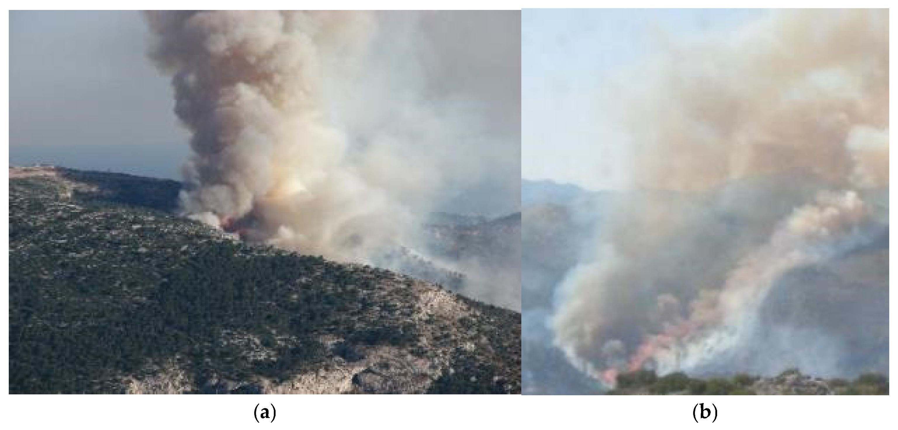
The estimated FDFMC values in Table 3 and Table 4 (from 3 to 12%) and the RH values in Table 4 show that eruptive fire behavior occurs within a wide range of ambient and fuel conditions. For example, regarding the Hymettus and Chosiario incidents presented in Table 3 (Figure 10), the estimated FDFMC was 5% and 3%, respectively while during the Korakaris incident, the estimated FDFMC was 12% and the RH was 57%.
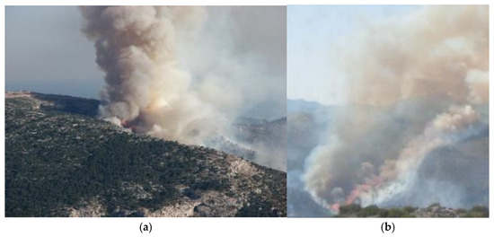
Figure 10.
Eruptive fire behavior in canyons: (a) Hymettus, in 2009 (Table 3, case 2) and (b) a clear view of flame attachment recorded during aerial firefighting in Chosiario, Lakonia (Table 3, case 4), in 2012 (photographs: Miltiadis Athanasiou).
Wildfire accidents are much more difficult to reconstruct and document than simply measuring and documenting fire behavior, due to moral standards, practical obstacles, and sometimes legal issues. Moreover, human behavior plays a critical role in wildland firefighter entrapment potential but it is difficult-to-assess [48]. Unfortunately, not all fire accidents are documented and shared, while many near-miss cases (e.g., Table 3, case 5 and Figure 3) are never analyzed and discussed [49].
Modelling eruptive fire behavior is a challenge. Addressing similarities from broader perspectives and gathering detailed information about canyon shapes, geometry elements, fuel variables such as the fuel bulk density, the calculated FWI [50,51] and wildfire spread patterns are important since they can significantly support future scientific research.
Author Contributions
Conceptualization, M.A.; methodology, M.A.; formal analysis, M.A.; investigation, M.A. and A.K.; resources, M.A. and A.K.; data curation, M.A.; writing—original draft preparation, M.A.; writing—review and editing, M.A., G.X. and E.V.A.; visualization, M.A.; supervision, M.A. All authors have read and agreed to the published version of the manuscript.
Funding
This research received no external funding.
Institutional Review Board Statement
Not applicable.
Informed Consent Statement
Not applicable.
Data Availability Statement
Data are available upon request.
Acknowledgments
We would like to thank Angelos Barbagiannis, Dimitrios Dimakogiannis, Spyridon Raptakis, Eleftherios Zacharias Errikos Psaltakis, Georgios Rodakis and Simos Nikitas for providing useful insights into some of the cases included in the database.
Conflicts of Interest
The authors declare no conflicts of interest.
References
- Mangan, R.J. Wildland Firefighter Fatalities in the United States: 1990–2006; US Forest Service, Missoula Technology and Development Center: Missoula, MT, USA, 2007.
- Diakakis, M.; Xanthopoulos, G.; Gregos, L. Analysis of forest fire fatalities in Greece: 1977–2013. Int. J. Wildland Fire 2016, 25, 797–809. [Google Scholar] [CrossRef]
- Molina-Terrén, D.M.; Xanthopoulos, G.; Diakakis, M.; Ribeiro, L.; Caballero, D.; Delogu, G.M.; Viegas, D.X.; Silva, C.A.; Cardil, A. Analysis of forest fire fatalities in Southern Europe: Spain, Portugal, Greece and Sardinia (Italy). Int. J. Wildland Fire 2019, 28, 85–98. [Google Scholar] [CrossRef]
- Haynes, K.; Short, K.; Xanthopoulos, G.; Viegas, D.; Ribeiro, L.M.; Blanchi, R. Wildfires and WUI Fire Fatalities. In Encyclopedia of Wildfires and Wildland-Urban Interface (WUI) Fires; Manzello, S.L., Ed.; Springer International Publishing: Cham, Switzerland, 2019; pp. 1–16. [Google Scholar] [CrossRef]
- Rothermel, R.C. Mann Gulch Fire: A Race that Couldn’t Be Won; Gen. Tech. Rep. INT-GTR-299; U.S. Department of Agriculture, Forest Service, Intermountain Research Station: Ogden, UT, USA, 1993; p. 10.
- Butler, B.W.; Bartlette, R.A.; Bradshaw, L.S.; Cohen, J.D.; Andrews, P.L.; Putnam, T.; Mangan, R.J. Fire Behavior Associated with the 1994 South Canyon Fire on Storm King Mountain, Colorado; Res. Pap. RMRS-RP-9; US Department of Agriculture, Forest Service, Rocky Mountain Research Station: Ogden, UT, USA, 1998; Volume 9, 82p.
- Dold, J.; Zinoviev, A. Fire eruption through intensity and spread rate interaction mediated by flow attachment. Combust. Theory Model. 2009, 13, 763–793. [Google Scholar] [CrossRef]
- Stipanicev, D.; Viegas, D. The Accident of Kornati (Croatia) 2007; Technical Report for Recent Forest Fire Related Accidents in Europe; JRC: Brussels, Belgium, 2009; p. 26. [Google Scholar]
- Viegas, D.; Caballero, D. The Accident of Guadalajara (Spain) 2005; Technical Report for Recent Forest Fire Related Accidents in Europe; JRC: Brussels, Belgium, 2009; pp. 3–17. [Google Scholar]
- Xanthopoulos, G.; Viegas, D.X.; Caballero, D. The Fatal Fire Entrapment of Artemida (Greece) 2007; Technical Report for Recent Forest Fire Related Accidents in Europe; JRC: Brussels, Belgium, 2009; p. 65. [Google Scholar]
- Castellnou, M.; Guiomar, N.; Rego, F.; Fernandes, P.M. Fire growth patterns in the 2017 mega fire episode of October 15, central Portugal. Adv. For. Fire Res. 2018, 447–453. [Google Scholar]
- Athanasiou, M.; Dimakogiannis, D. Wildfire behaviour associated with the August 22, 2011 accident in Vathy, Lakonia, Greece. Firef. Rev. 2018, 189, 4–9, (In Greek with English Abstract). [Google Scholar]
- Athanasiou, M.; Xanthopoulos, G. The behaviour of the deadly wildfire of 23 July 2018, in Northeastern Attica, Greece. In Proceedings of the 20th Hellenic Forestry Conference 900 p., Trikala, Greece, 3–6 October 2021; pp. 64–72, (In Greek with English Abstract). [Google Scholar]
- Dold, J.; Simeoni, A.; Zinoviev, A.; Weber, R. The Palasca Fire, September 2000: Eruption or Flashover; Technical Report for Recent Forest Fire Related Accidents in Europe; JRC: Brussels, Belgium, 2009; p. 54. [Google Scholar]
- Wilson, C.C. Fatal and near-fatal forest fires: The common denominators. Int. Fire Chief 1977, 43, 9–15. [Google Scholar]
- Viegas, D.X. A mathematical model for forest fires blowup. Combust. Sci. Technol. 2004, 177, 27–51. [Google Scholar] [CrossRef]
- Viegas, D.X.; Pita, L.P. Fire spread in canyons. Int. J. Wildland Fire 2004, 13, 253–274. [Google Scholar] [CrossRef]
- Viegas, D.; Pita, L.; Ribeiro, L.; Palheiro, P. Eruptive fire behaviour in past fatal accidents. In Proceedings of the Eighth International Wildland Fire Safety Summit, Missoula, MT, USA, 26–28 April 2005; pp. 26–28. [Google Scholar]
- Viegas, D.X. Parametric study of an eruptive fire behaviour model. Int. J. Wildland Fire 2006, 15, 169–177. [Google Scholar] [CrossRef]
- Thomas, D.; Butry, D.; Gilbert, S.; Webb, D.; Fung, J. The costs and losses of wildfires. NIST Spec. Publ. 2017, 1215, 1–72. [Google Scholar]
- Viegas, D.X.; Rodrigues, A.; Abouali, A.; Almeida, M.; Raposo, J. Fire downwind a flat surface entering a canyon by lateral spread. Fire Saf. J. 2021, 122, 103349. [Google Scholar] [CrossRef]
- Balbi, J.-H.; Chatelon, F.J.; Rossi, J.L.; Simeoni, A.; Viegas, D.X.; Rossa, C. Modelling of eruptive fire occurrence and behaviour. J. Environ. Sci. Eng. B 2014, 3, 115–132. [Google Scholar]
- Page, W.G.; Butler, B.W. Fuel and topographic influences on wildland firefighter burnover fatalities in Southern California. Int. J. Wildland Fire 2018, 27, 141–154. [Google Scholar] [CrossRef]
- Viegas, D.; Simeoni, A. Eruptive behaviour of forest fires. Fire Technol. 2011, 47, 303–320. [Google Scholar] [CrossRef]
- Xanthopoulos, G. Forest fire related deaths in Greece: Confirming what we already know. Proc. Wildfire 2007, 1–12. [Google Scholar]
- Xanthopoulos, G. Wildfires and safety issues in Greece. In Current International Perspectives on Wildland Fires, Mankind and the Environment; Alexander, L., Ed.; Nova Science Publishers, Inc.: New York, NY, USA, 2015; pp. 157–176. [Google Scholar]
- Athanasiou, M.; Xanthopoulos, G. Wildfires in Mediterranean shrubs and grasslands, in Greece: In situ fire behaviour observations versus predictions. In Proceedings of the 7th International Conference on Forest Fire Research on Advances in Forest Fire Research, Coimbra, Portugal, 17–20 November 2014. [Google Scholar]
- Athanasiou, M.; Xanthopoulos, G. Fire behaviour of the large fires of 2007 in Greece. In Proceedings of the 6th International Conference on Forest Fire Research, Coimbra, Portugal, 15–18 November 2010. [Google Scholar]
- Athanasiou, M. Development of an Optimal Methodology for Forecasting Forest Fire Behaviour in Greece. Ph.D. Thesis, National and Kapodistrian University of Athens, Athens, Greece, 2015; p. 408, (In Greek with English Abstract). [Google Scholar]
- NWCG. Glossary of Wildland Fire Terminology. 2005. Available online: https://www.fs.usda.gov/Internet/FSE_DOCUMENTS/fswdev3_009827.pdf (accessed on 13 January 2025).
- Heward, H. Surface Fire. In Encyclopedia of Wildfires and Wildland-Urban Interface (WUI) Fires; Manzello, S.L., Ed.; Springer International Publishing: Cham, Switzerland, 2019; pp. 1–5. [Google Scholar]
- Wagner, C.V. Conditions for the start and spread of crown fire. Can. J. For. Res. 1977, 7, 23–34. [Google Scholar] [CrossRef]
- Xanthopoulos, G.; Athanasiou, M. Crown Fire. In Encyclopedia of Wildfires and Wildland-Urban Interface (WUI) Fires; Manzello, S.L., Ed.; Springer International Publishing: Cham, Switzerland, 2019; pp. 1–15. [Google Scholar]
- Brown, A.; Davis, K.P. Forest Fire: Control and Use, 2nd ed.; McGraw-Hill: Whitby, ON, Canada, 1973. [Google Scholar]
- Pyne, S.J. Introduction to Wildland Fire. Fire Management in the United States; John Wiley & Sons: Hoboken, NJ, USA, 1984. [Google Scholar]
- Chandler, C.; Cheney, P.; Thomas, P.; Trabaud, L.; Williams, D. Fire in Forestry. Volume 1. Forest Fire Behavior and Effects. Volume 2. Forest Fire Management and Organization; John Wiley & Sons: Hoboken, NJ, USA, 1983. [Google Scholar]
- Pyne, S.J.; Andrews, P.L.; Laven, R.D. Introduction to Wildland Fire; John Wiley & Sons: Hoboken, NJ, USA, 1996. [Google Scholar]
- Venturi, G.B. Recherches Expérimentales sur le Principe de la Communication Latérale du Mouuement dans les Fluides, Appliqué à L’explication de Différens Phénomènes Hydrauliques; English Translation in 1799. “Experimental Researches Concerning the Principle of the Lateral Communication of Motion in Fluids, Applied to the Explanation of Various Hydraulic Phenomena” in Journal of Natural Philosophy, Chemistry and the Arts; Chez Houel et Ducrosand et Théophile Barrois: Paris, France, 1797; Volume 2: 172–179, 273–276, 422–426, 487–494; Volume 3: 13–22, 59–61. [Google Scholar]
- Young, T. Outlines of Experiments and Inquiries Respecting Sound and Light: From the Philosophical Transactions; Philosophical Transactions of the Royal Society of London: London, UK, 1800; Volume 90, pp. 106–150. [Google Scholar]
- Simcox, S.; Wilkes, N.; Jones, I. Computer simulation of the flows of hot gases from the fire at King’s Cross underground station. Fire Saf. J. 1992, 18, 49–73. [Google Scholar] [CrossRef]
- Sharples, J.J.; Gill, A.M.; Dold, J.W. The trench effect and eruptive wildfires: Lessons from the King’s Cross Underground disaster. In Proceedings of the Australian Fire and Emergency Service Authorities Council 2010 Conference, Darwin, NT, Australia, 8–10 September 2010; pp. 8–10. [Google Scholar]
- Chatelon, F.-J.; Sauvagnargues, S.; Dusserre, G.; Balbi, J.H. Generalized Blaze Flash, a “flashover” behavior for forest fires-Analysis from the firefighter’s point of view. Open J. For. 2014, 4, 547–557. [Google Scholar] [CrossRef]
- Gould, J.S.; McCaw, W.; Cheney, N.; Ellis, P.F.; Knight, I.; Sullivan, A.L. Project Vesta: Fire in Dry Eucalypt Forest: Fuel Structure, Fuel Dynamics and Fire Behaviour; Csiro Publishing, Department of Environment and Conservation: Canberra, Australia, 2008. [Google Scholar]
- Rothermel, R.C. How to Predict the Spread and Intensity of Forest and Range Fires; US Department of Agriculture, Forest Service, Intermountain Forest and Range: Ogden, UT, USA, 1983; Volume 143.
- Dimitrakopoulos, A. Mediterranean fuel models and potential fire behaviour in Greece. Int. J. Wildland Fire 2002, 11, 127–130. [Google Scholar] [CrossRef]
- Rodrigues, A.; Ribeiro, C.; Raposo, J.; Viegas, D.X.; André, J. Effect of canyons on a fire propagating laterally over slopes. Front. Mech. Eng. 2019, 5, 41. [Google Scholar] [CrossRef]
- Xanthopoulos, G.; Athanasiou, M. The fires of Mount Hymettus near Athens Greece (1996–2017): History and fire behavior characteristics. In Proceedings of the 8th International Conference on Forest Fire Research, Coimbra, Portugal, 9–16 November 2018. [Google Scholar]
- Page, W.G.; Freeborn, P.H.; Butler, B.W.; Jolly, W.M. A classification of US wildland firefighter entrapments based on coincident fuels, weather, and topography. Fire 2019, 2, 52. [Google Scholar] [CrossRef]
- Gibos, K.; Fitzpatrick, K.; Elliott, S. Why Do We Still Not Know How to Prevent Firefighter Entrapments?—Thoughts and Observations from a Few Perplexed Fire Practitioners. Fire 2022, 5, 8. [Google Scholar] [CrossRef]
- Turner, J.A.; Lawson, B.D. Weather in the Canadian Forest Fire Danger Rating System: A User Guide to National Standards and Practices; Information Report. BC-X-177; Canadian Forest Service, Pacific Forestry Centre: Victoria, BC, Canada, 1978; 40p. [Google Scholar]
- Wagner, C.V. Structure of the Canadian Forest Fire Weather Index; Environment Canada, Forestry Service Ottawa: Ottawa, ON, Canada, 1974; Volume 1333. [Google Scholar]
Disclaimer/Publisher’s Note: The statements, opinions and data contained in all publications are solely those of the individual author(s) and contributor(s) and not of MDPI and/or the editor(s). MDPI and/or the editor(s) disclaim responsibility for any injury to people or property resulting from any ideas, methods, instructions or products referred to in the content. |
© 2025 by the authors. Licensee MDPI, Basel, Switzerland. This article is an open access article distributed under the terms and conditions of the Creative Commons Attribution (CC BY) license (https://creativecommons.org/licenses/by/4.0/).
