Abstract
With the French at the door, on May 31st of 1509, the Head of the Venetian Garda fleet received the order to burn and sink the ships and come back to Venice: the war on the lake was temporarily lost. The small fleet, whose base was at Lazise, was formed by one light galley and two fustas, so the commandant sunk the galley and one fusta in front of the town and went with the third ship to the northern lake to take a safe trip to Venice on horseback. One shipwreck was discovered in 1960 and was studied in several campaigns, but it was not clear if it was a small galley or a large fusta. New research was started in 2018 with BENĀCUS, a project of the Department of Humanities and Cultural Heritage of the University of Udine, in a joint venture with the Trieste and Firenze Universities, and under the Superintendency for the Archaeology, Arts and Landscape of the provinces of Verona, Vicenza and Rovigo. The aim of this project was an historical research and geophysical survey to map the underwater cultural heritage (UCH) of Garda Lake.
1. Introduction
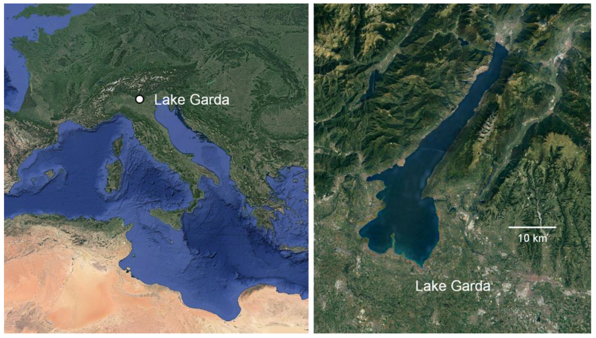
The Benacus project was born from the agreement with the Superintendence of Verona and in collaboration with the Department of Mathematics and Geosciences of the University of Trieste, and the Department of Industrial Engineering of the University of Florence. The project focuses on the research and the mapping of the submerged cultural heritage of Lake Garda (Figure 1) using an interdisciplinary method that can be summarized as follows: collection and analysis of historical and archival sources, combing of the unpublished archaeological material available at the offices of the Superintendence, organization of remote sensing campaigns, and ground truthing of anomalies.

Figure 1.
General geographic framework (created by Massimo Capulli; background Image ©Google).
The area selected for a first experimentation (object of the present contribution) sits across the line that divides the lake between the communes of Lazise and Garda, where the so-called Galea lies. We are using the known position of the Galea as a starting point for the calibration of the instruments, and we believe that the second shipwreck, not yet identified, should lie in the same part of the lake.
2. Historical Background
The Serenissima Republic of Venice made use of its maritime ability also for the conquest and the maintenance of the “Dominio di Terraferma” [1,2], with a capillary control of rivers and lakes.
The regions of northern Italy are in fact crossed by many waterways, which are often wide and almost always slow-moving, and for these reasons allowed Venice to make the best use of the knowledge and technology that were most peculiar to it: that is to bring as close as possible to the battlefields the naval units that had already allowed it to establish its dominance on the seas. The use of properly equipped river fleets gave way to a new approach to land wars; this meant not only a faster movement of men and means, but also a new flexibility of attack [3]. Along the course of the rivers, real natural defensive structures, the Serenissima could move its naval units with great freedom and rapidity, equipped with artillery more or less heavy depending on the type of boats used. This is the case of Lake Garda, the largest lake in Italy, where a fleet was set up to guard the Venetian waters. Its presence was also guaranteed by resorting to an amazing feat, which was called galeas per montes.
The episode of the transport of a Venetian fleet through the mountains is to be ascribed to the war between the Republic of Venice and the Duchy of Milan (1426–1454 AD). The conflict was triggered by the Venetians who wanted to consolidate their power over the Lombard possessions, when they waged a preventive war against the Duke of Milan, Filippo Visconti. Venice hired a great captain of fortune named Nicolò Piccinino [4], who was victorious in a series of clashes in the lands of Brescia, but above all, was also a skillful diplomat, and thus succeeded in detaching from Venice his precious Mantuan ally who controlled the southern part of the lake [5].
The city of Brescia, which had always been faithful to the Serenissima, found itself besieged by Milanese troops, without men and provisions. The situation did not seem to leave any hope in sight, as the connections with Venice were precluded, both for the plain and for most of the lake of Garda, which were now in the hands of Piccinino. However, there was still a route that remained possible, an alternative route known for a long time [6], which from Brescia allowed one to reach the port of Ponale in the north of the lake through the Val Sabbia and the Valle di Ledro. In order to connect Ponale to the Veronese shore of the lake, which was under Venetian control, it was necessary to station ships on Lake Garda. As the enemy controlled the southern part of the lake, where there is the emissary that connects it to the sea, in December 1438 the Venetian Senate decided to send a fleet to Garda through the mountains [7]. This prodigious feat was also recorded in a map, called the Almagià map, made between 1463 and 1467 on parchment and has an area of almost seven square meters [8].
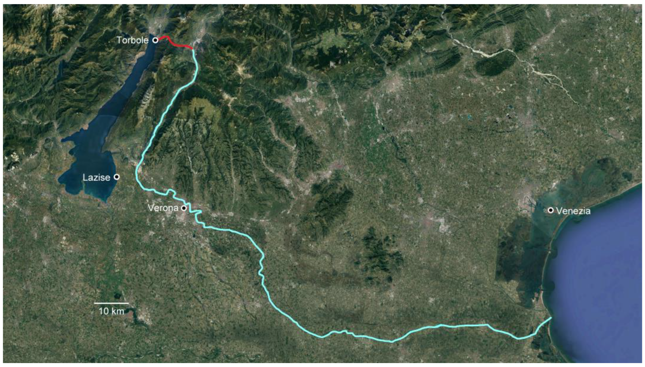
According to most sources, the fleet was composed of two light galleys, three fustas and twenty-five copani [9], (pp. 12–15); the fleet arrived at the mouth of the river Adige, which went up until beyond Verona, and using logs and numerous oxen, it crossed the pass at Mori until it reached Torbole and then the lake (Figure 2). The incredible operation of the Serenissima succeeded in its intent, and Brescia was rescued. The following year, however, the Venetian fleet was destroyed by that of Piccinino. A second fleet was therefore prepared, but not sent from Venice because the enterprise through the mountains, although successful, was very challenging and expensive. It was thus decided to send pieces, made on the model of a light galley designed by master Nicolò Palopano, to the lake where they would be assembled by Giorgio di Giovanni [10,11]. This second fleet was more fortunate than the one transported through the mountains. Having thwarted an attempt to destroy it when it was still under construction [12], this second fleet fought against the Milanese army and won. Despite these victorious achievements, the life of the second fleet was almost as short. In fact, following the famous peace of Lodi (1454 AD) it was laid to rest in the arsenal of Lazise. Some scholars have argued that the ships based at Lazise and sunk during the Cambrai war belonged to the first, older fleet [13,14], although this hypothesis seems unlikely to us because it implies that these vessels lasted 70 years.

Figure 2.
Route of the ships from Venice to Lake Garda: the line through the Adige River and the points the passage through the mountains (created by Massimo Capulli; background Image ©Google).
Since the birth of the “Dominio di Terraferma”, at the beginning of the 14th century, the Venetians had kept a strategy in foreign policy aimed at breaking adversary coalitions, but this mechanism was broken when the representatives of the Emperor Maximilian I of Hapsburg, Louis XII of France and Ferdinand the Catholic King of Aragon signed an anti-Venice treaty on 10 December 1508, in Cambrai, a small town in the north of France [15]. Later, on 23 March 1509, the League was completed with the accession of Pope Julius II.
Even on the lake, the Venetians prepared for the war that now seemed imminent. Usually, a Captain elected by the Council of Verona commanded the Garda fleet, but in this particular case, circumstances the Senate of the Serenissima had this prerogative, so on 21 April 1509 Zaccaria Loredan was elected to this position [16], (p. 113). A Venetian patrician of proven experience, having already been captain of bastard galleys, Loredan was ordered to go to Garda, together with some sailors and crossbowmen, to rearrange the ships in the arsenal of Lazise and prepare for combat. However, following the defeat suffered by the Venetians at Agnadello on 14 May 1509, the French militia of Louis XII swept into the mainland without almost any resistance, so much so that the Venetian Senate ordered its Captain of the Garda forces to burn the galley and the fustas (a small narrow galley), and return to their lands [16], (p. 316). So, in order not to surrender the ships to the enemy, on 31 May 1509, a few hundred meters away from the port of Lazise, Zaccaria Loredan carried out the order of the Senate and sank them.
3. The Shipwreck of Lazise
The presence of the Venetian ships has always remained alive among the inhabitants of Lazise and especially among the fishermen, who sometimes found pieces of wood in their nets [17]. After a fortuitous sighting in 1958 by a diver who was looking for a missing person, the official discovery of a shipwreck took place in the summer of 1962, when Enrico Scandurra, a volunteer working with the Museum of Natural History of Verona, spotted it. Starting in the same year he conducted some excavation campaigns which ended in 1968 [18]. These were followed by four other campaigns on the same shipwreck on behalf of the Italian Ministry of Cultural Heritage: in 1990 [19], 1996 [20], 1998 and 2003 [9], (pp. 37–60).
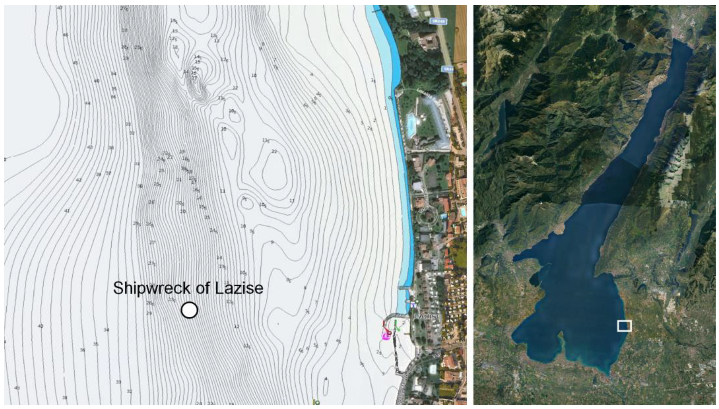
Therefore, only one of the ships was excavated and identified as the “galley.” The wreck lies at a depth between 24 and 27 m, on a muddy seabed, about 500 m from the modern port of Lazise (Figure 3).
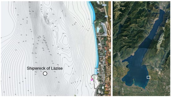
Figure 3.
The area of the shipwreck of Lazise (created by Massimo Capulli; background Image ©Google).
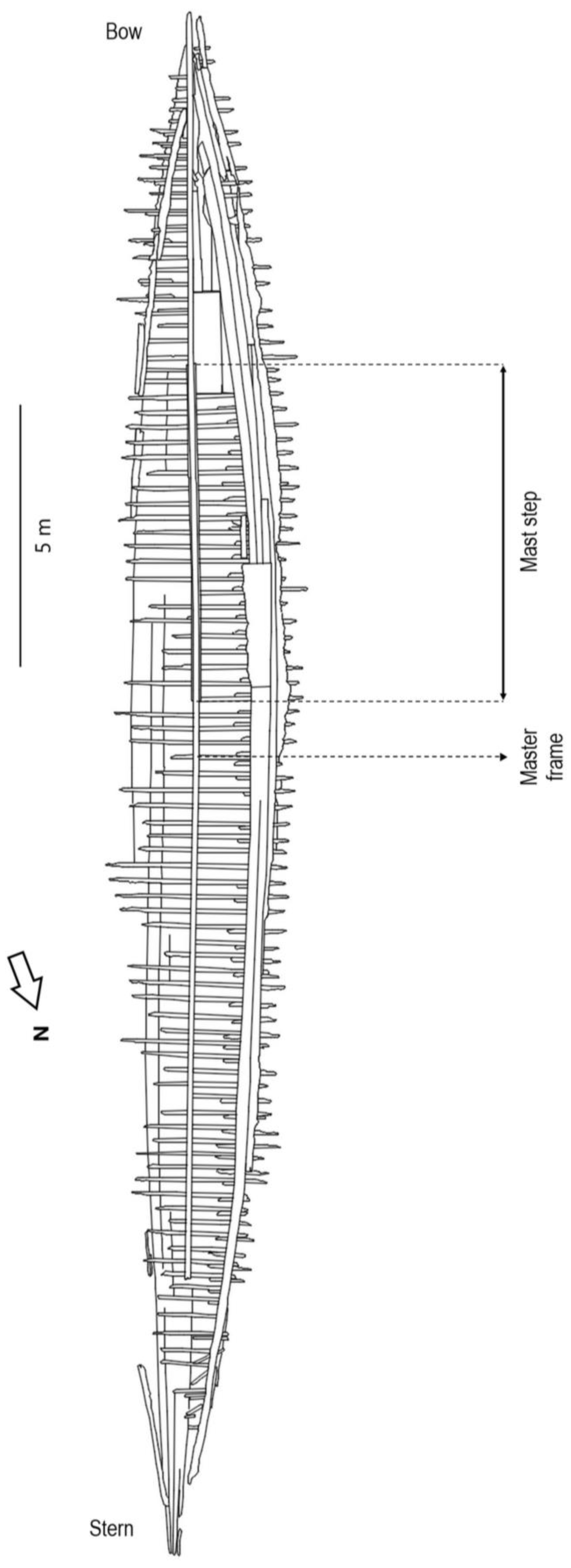
The hull, which has been preserved for a total length of just under 30 m and a maximum width of three and a half meters, lies in a doubly inclined position due to the conformation of the seabed, which is slightly sloping. Several constituent elements of the vessel are preserved: the keel, the frames, the keelson, the mast step (Figure 4) and one bilge stringer [9], (pp. 99–117).
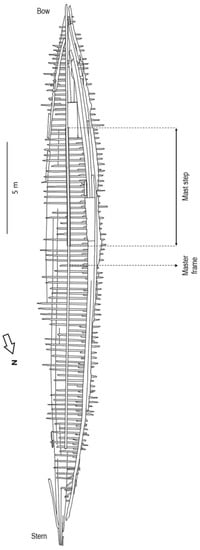
Figure 4.
The hull of the shipwreck of Lazise (created by Massimo Capulli; background Image [9], p. 35).
The latest research of 2003 has allowed the identification of the master frame, which is fourteen meters and seventy-two centimeters from the bow and fourteen meters and seventy-six centimeters from the stern, placing the center of gravity in the middle of the length of the ship. This means that the hull was built following the fifteenth-century criteria [21], because only from the following century was the center of gravity moved towards the bow, probably to compensate for the weight of the rembata. This was a sort of platform, transverse to the axis of the ship, on which the heavy artillery was placed. On the other hand, according to our studies, there are still doubts about the type of ship of this hull. As mentioned above, on the same day the Venetians sank the two ships near Lazise, a galley and a fusta, they sailed on the second fusta to a point further north where they could disembark and return to Venice on horseback [16], (pp. 333–334).
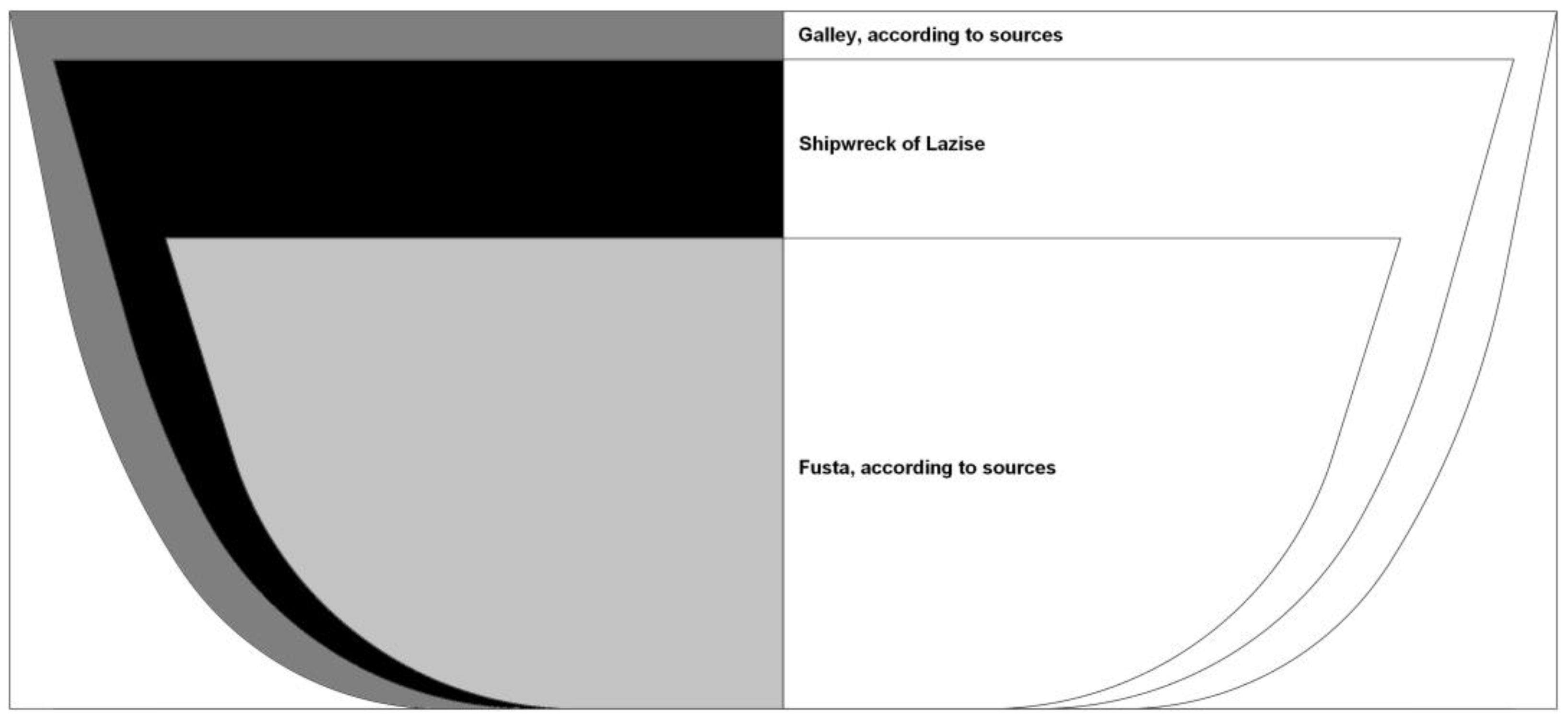
Of the ships sunk in Lazise, only one has been discovered and immediately uncritically believed to be the medieval galley. Comparing the measurements of the shipwreck of Lazise with the available treatises on Venetian shipbuilding [22], it would not appear to be similar either to the class of the light galleys, or to the larger fustas: it is in fact too small to be a galley, but at the same time too large to be one of the largest documented fustas (Figure 5).
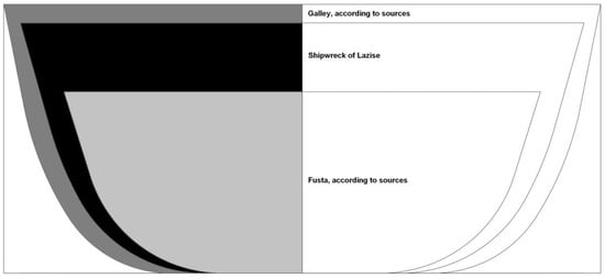
Figure 5.
The shipwreck of Lazise: between a Venetian Galley and a Fusta (created by Massimo Capulli; background Image [9], p. 120).
Regardless, this is a very rare example of a medieval longship [23]. Only the wrecks of Camarina (XII-XIV AD) in Sicily, which lacks a thorough study [24], those of Contarina [25] and the small boat with alternating asymmetric floor-timbers of Precenicco [26], are known in Italy, but mostly the Venetian galley of San Marco in Boccalama (XIV AD) in the Venice lagoon, however we only have preliminary studies from both [27,28].
4. The New Research
The first part of the Benacus project involved a study of the historical period from the Venetian–Visconti war to the war of Cambrai [29]. Therefore, it was necessary to order the diaristic, narrative and literary testimonies on the Venetian Garda fleet. Subsequently, the possible archival sources, which have never been thoroughly searched, on the creation, maintenance and sinking of the Venetian ships of the Garda were examined.
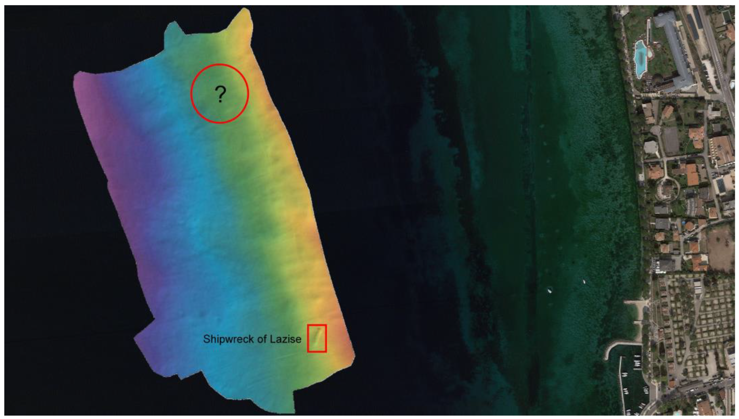
In particular, a source that provides us with the position of both wrecks, specifying also which are to be referred to the galley and which to the fusta, was of fundamental importance. In fact, both the alignments of landmarks and the distances to the north of the port and then from the shore are reported. While the former are no longer usable today, due to urban changes that have occurred over the centuries, it is possible to reason about the latter. However, there was a small problem about the port from which to measure the distance to the point on the coast from which to measure the distance to the lake. In the past there were two ports, one near the arsenal and one near the castle, which are about 160 m apart. To our advantage we had the exact position of one of the wrecks and were thus able to compare the data. The result was that the known shipwreck roughly corresponds to the position reported for the galley. In fact, the distance from the coast perfectly corresponds to the position of the galley, while the distance of the point on the shore towards the south is beyond the port of the arsenal and a few meters beyond that of the Castle, which is probably the port mentioned by the literary source. It is quite evident that by using this system we were able to calculate the point where the other shipwreck should presumably be located. Although at this point, we had managed to circumscribe the area of the site, an extensive survey was planned. Specifically, we should have used side scan sonar in case the remains of the hull sat proud of the lake bottom, while for buried anomalies, as an alternative to the classic Sub Bottom Profiler, we wanted to jointly use ERT (Electrical Resistivity Tomography) and GPR (Ground Penetrating Radar). The advantage offered by this methodology, usable in freshwater, already successfully tested in the Stella River [30], is to clearly identify a shipwreck, also in the absence of other artifacts, because the preserved wood is an electrical insulator even when soaked. This investigation, initially suspended due to the limitations imposed by the COVID-19 health emergency, was carried out during 2021. Specifically, the survey was conducted by Explora srl, a Spin-Off of the University of Trieste, using mainly multi beam technology (MBES). The instrument used was the Norbit iWBMS integrated with the Applanix Wave Master GNSS for all attitude and motion checks, while the system was interfaced to the on-board computer where QPS Qinsy software provided the information for navigation and the recording of bathymetric and signal strength data. The area of investigation covers about 100 × 60 m covered with fifteen passages parallel to the coast, i.e., one every 4 m, however, unfortunately it gave a negative result: none of the targets detected by the remote instruments were of archaeological interest (Figure 6).
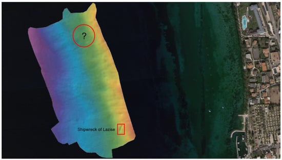
Figure 6.
The multibeam survey with the evident shipwreck of Lazise and the area calculated according to the sources for the second shipwreck (created by Massimo Capulli; background Image ©Google).
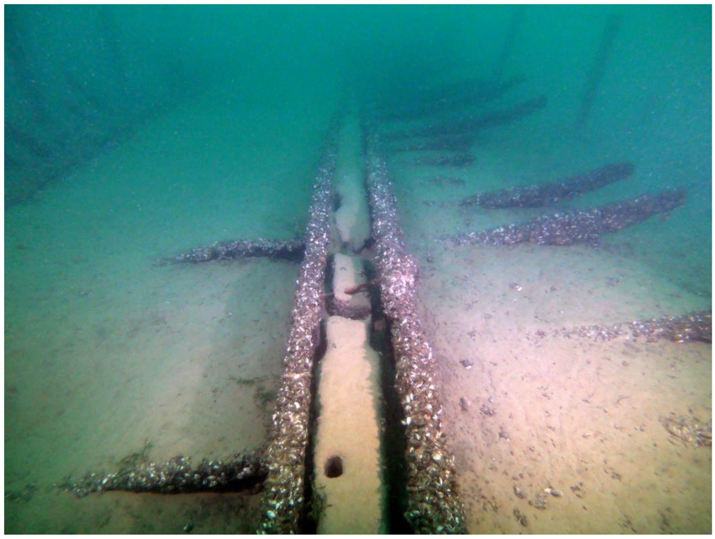
However, at the same time as the historical–archival research, monitoring and evaluation of the state of the already excavated shipwreck were conducted. This was also thanks to the collaboration of the Carabinieri (an Italian police) divers, assisted by their Unit for the Protection of Cultural Heritage. On this occasion it was unfortunately observed that the hull framework, for the part emerging from the sediment, was massively colonized by an almost uniform layer of malacofauna (Figure 7). This is Dreissena polymorpha, a well-known type of extremely invasive bivalve mollusk [31], which has been present in Lake Garda since the mid-1970s [32,33], but just in shallow water.

Figure 7.
The shipwreck of Lazise in 2019: in the foreground the molluscs that totally cover the mast step (Massimo Capulli).
At the depth of 24–27 m at which the wreck is found, biological activity in Lake Garda is normally very limited, but during our dives we were able to ascertain that the whole wreck is full of this particular type of mollusk. We thus had to record that while in the past they were only found at shallow depths, because they need a temperature of at least 11 °C for reproduction [34], now instead it is possible to find these mollusks even at greater depths [35] and this is due to the increase in the average Garda lake temperature of 1.6 degrees Celsius probably due to climate change [36].
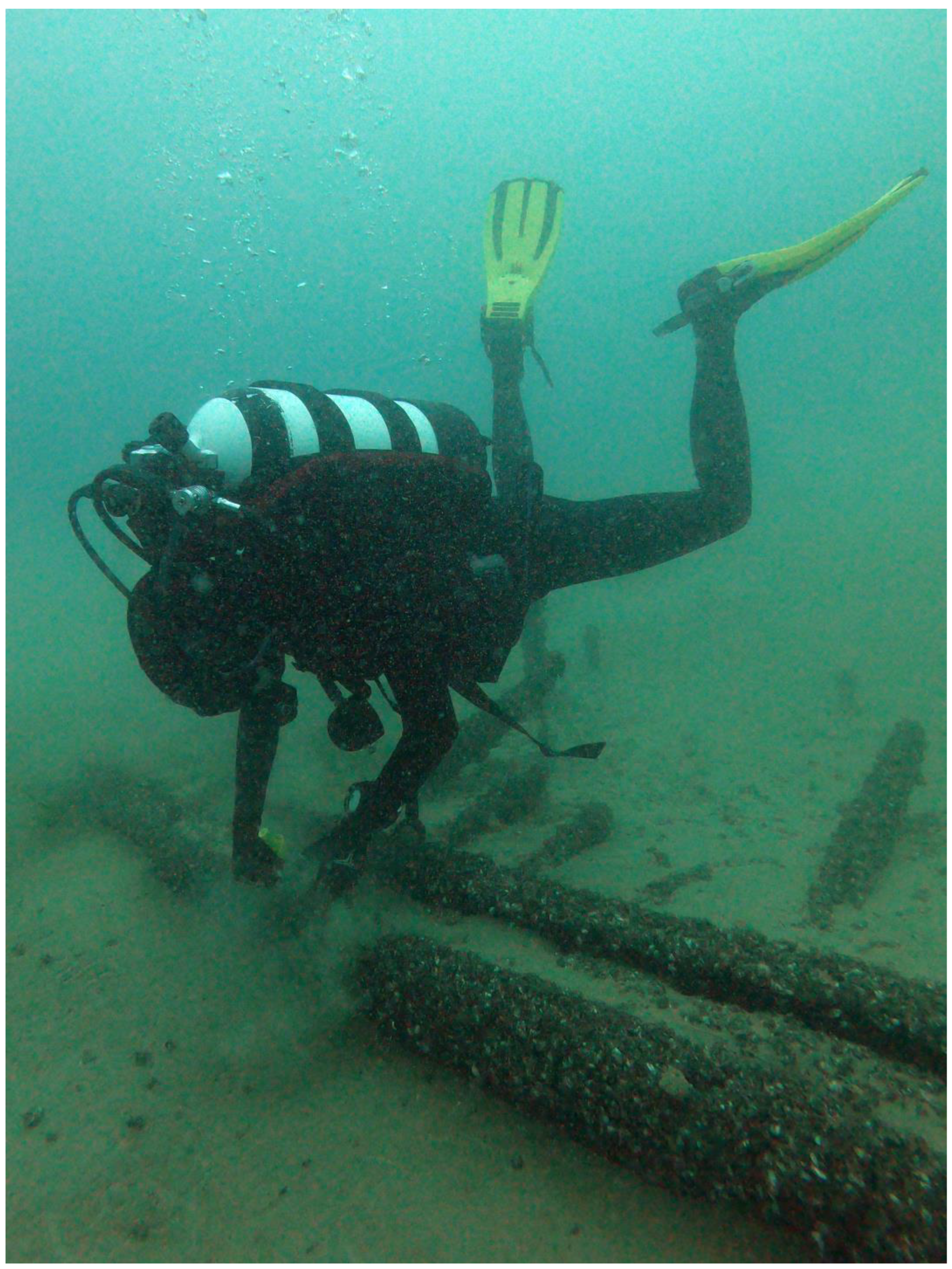
While removing the mollusks in some parts of the hull, an extremely worrying fact was then observed, namely the deterioration of the wood, which has become thinner at many points (even 5 cm were missing from the keelson), as well as a fracture that misaligned it. However, it must be assessed with certainty whether this damage was caused by Dreissena polymorpha and/or by an increase in the average lake temperature [37]. Indeed, based on the scientific literature, these mussels are filter feeders and remove much of the plankton on which juvenile fish depend and can cause several changes in aquatic habitats [38]. From the protection of the underwater cultural heritage point of view, they attach themselves to hard surfaces such as poles of prehistoric villages [39] or shipwrecks; however, in the latter case, while it seems certain that they damage metal ships, there are no studies yet on the impact on wood [40]. It is certain that they can weaken wooden hulls by destroying all the joints nailing them together, while for the wooden parts alone the question seems to remain open. In any case, for the Venetian shipwreck of Lake Garda, the competent Superintendency has launched a reclamation and protection program which will be implemented as soon as possible, while the University of Udine is planning a collaboration with other research institutions to clarify the cause of this degradation of the wood also in fresh waters (Figure 8).

Figure 8.
Molluscs sampling in 2021 (Massimo Capulli).
5. Conclusions
The Benacus project has the ambition to develop over the years a broad research program for the mapping of the submerged cultural heritage of Lake Garda. The area identified for an initial experimentation was that of the south-eastern part of the lake, which was the scene of the sinking of a small Venetian fleet in 1509. This step is also aimed to a better historical-archaeological reconstruction of the events connected to the fleet of the Serenissima in the period between the Veneto-Visconti war and that of Cambrai.
The knowledge of the position of one of the two shipwrecks of Lazise should have been the starting point for the calibration of the instruments (SSS, ERT and GPR) and the research of the second one, which thanks to the new and in-depth historical-archival research has been roughly positioned. The outcome of this survey was nonetheless negative. Among the possible causes, the main ones may be an error in the sources or in their interpretation, or a total and thick natural covering of the second shipwreck. For example, in Lake Garda, sedimentation rates in the 1963–1989 time-interval were estimated to be in the order of 2 cm/y. According to the authors, this rate can only be considered representative of the past century before present [41], but this means that from the discovery of the Lazise shipwreck to today (1958–2022), we could have over 120 cm of additional sediment for the second wreck.
The Benacus project has anyhow brought back the attention on this important Venetian ship, after 16 years from the last dives. This was an opportunity to discover, hopefully in time, that the hull is deteriorating, and that action must be taken to protect one of the only two Venetian warships that have come down to us [42]. Climate change thus seems to be putting us in front of new challenges in order to protect the underwater cultural heritage [43] and perhaps to take away some old certainty, such as the one that the fresh waters of a lake do not cause major conservation problems.
Funding
This research was supported by the PRID funds of the Department of Humanities and Cultural Heritage—University of Udine (Italy).
Acknowledgments
The author would like to thank Giovanna Falezza and Alessandro Asta of the Italian Ministry of Culture, Michele Pipan of the University of Trieste, Andrea Zannini of the University of Udine, Mauro Bondioli of Institute for Maritime Heritage Ars Nautica; Paolo Amighetti of the Catholic University of Milan and Esplora srl for the work done so far. Last but not least, Staci Willis of the Houston Community College, for checking the English.
Conflicts of Interest
The author declares no conflict of interest.
References
- Viggiano, A. Il Dominio da terra: Politica e istituzioni. In Storia di Venezia. Dalle Origini Alla Caduta Della Serenissima. Vol. IV: Il Rinascimento. Politica e Cultura; Tenenti, A., Tucci, U., Eds.; Istituto della Enciclopedia Italiana-Treccani: Roma, Italy, 1996; pp. 465–528. [Google Scholar]
- Law, J.E. The Venetian Mainland State in the Fifteenth Century. In Transactions of the Royal Historical Society 2; Cambridge University Press: London, UK, 1992; pp. 154–174. [Google Scholar]
- Mallett, M. La conquista della Terraferma. In Storia di Venezia. Dalle Origini Alla Caduta Della Serenissima. Vol. IV: Il Rinascimento. Politica e Cultura; Tenenti, A., Tucci, U., Eds.; Istituto della Enciclopedia Italiana-Treccani: Roma, Italy, 1996; pp. 181–244. [Google Scholar]
- Mallett, M. Mercenaries and Their Masters: Warfare in Renaissance Italy; Pen & Sword: Barnsley, UK, 2019. [Google Scholar]
- Tarducci, G. L’alleanza Visconti-Gonzaga del 1483 contro la Repubblica veneta. Archivio Storico Lombardo 1899, III, 265–329. [Google Scholar]
- Rosini, E. Il Garda prima dell’anno Mille. Arch. Veneto 1997, CXLIX, 5–40. [Google Scholar]
- Renier, P. Testimonianze sul Trasporto Delle Navi da Venezia al Garda Eseguito dai Veneziani nel 1439; S.E.: Venezia, Italy, 1967. [Google Scholar]
- Mazzi, G. Governo del territorio e cartografia veneta tra Quattrocento e Cinquecento. In Verona e il suo Territorio nel Quattrocento. Studi Sulla Carta dell’Almagià; Lodi, S., Varanini, G.M.S., Eds.; Cierre: Verona, Italy, 2014; pp. 19–60. [Google Scholar]
- Capulli, M. Le Navi della Serenissima. La “Galea” di Lazise; Marsilio: Venezia, Italy, 2003; pp. 12–117. [Google Scholar]
- Bondioli, M. L’arte della costruzione navale veneziana tra il XV e il XVI secolo: Riflessioni e nuovi documenti. In Navalia. Archeologia e Storia; Ciciliot, F., Ed.; International Propeller Club: Savona, Italy, 1996; pp. 139–155. [Google Scholar]
- Bondioli, M.; Penzo, G. Teodoro Baxon e Nicola Palopano proti delle galee sottili. L’influsso greco nelle costruzioni navali veneziane della prima metà del XV secolo. Archeol. Delle Acque 1999, 2, 67–80. [Google Scholar]
- Biondo, F. La Seconda Parte de le Historie del Biondo, Ridotte in Compendio per Lucio Fauno; Michele Tramezzino: Venezia, Italy, 1550; p. 116. [Google Scholar]
- Gerosa, M. Il Benaco. Nei Ricordi e Nelle Sovrane Bellezze; Tip. Queriniana: Brescia, Italy, 1956; Volume 2. [Google Scholar]
- Scandurra, E. The Maritime Republics: Medieval and Renaissance Ship in Italy. In A History of Seafaring Based on Underwater Archaeology; Bass, G., Ed.; Thames and Hudson: New York, NY, USA, 1972; p. 209. [Google Scholar]
- Shaw, C. Treaty of Cambrai (1529). In The Encyclopedia of Diplomacy; Martel, G., Ed.; Wiley-Blackwell: Hoboken, NJ, USA, 2018; pp. 1–4. [Google Scholar] [CrossRef]
- Sanudo, M. I diarii (Nella Trascrizione di Nicolò Barozzi), Tomo VIII.; Venezia, Italy, 1882; pp. 113–334. Available online: http://bpfe.eclap.eu/eclap/axmedis/a/a58/00000-a58eeb91-f35c-40f9-8e5a-bdc316384e53/2/~saved-on-db-a58eeb91-f35c-40f9-8e5a-bdc316384e53.pdf (accessed on 29 January 2023).
- Cavazzocca Mazzanti, V. Navi affondate nel Lago di Garda. Mem. Dell’ateneo Di Salò 1931, II, 15–19. [Google Scholar]
- Scandurra, E. Una flotta attraverso i monti. Mondo Sommerso 1969, XI-2, 164–166. [Google Scholar]
- D’Agostino, M.; Fozzati, L. La galea veneziana del XVI secolo da Lazise. In C’era una Volta Lazise; Neri Pozza: Verona, Italy, 1992; pp. 121–126. [Google Scholar]
- Bondioli, M.; D’Agostino, M.; Fozzati, L. Lago di Garda, Lazise (VR). Relitto di nave lunga veneziana. Relazione preliminare. Archeol. Mediev. 1997, XXIV, 145–153. [Google Scholar]
- Bondioli, M.; Capulli, M. Il relitto cinquecentesco della fusta veneziana di Lazise: Analisi strutturale e studio sul metodo di configurazione dell’innalzamento verticale dei madieri (stellatura) mediante l’uso dei sesti. In Proceedings of the Atti del I Convegno Nazionale, NAVIS-Rassegna di Studi di Archeologia, Etnologia e Storia Navale 4, Cesenatico, Italy, 4–5 April 2008; Caniato, G., D’Agostino, M., Medas, S., Eds.; Libreriauniversitaria: Bari, Italy, 2010; pp. 83–88. [Google Scholar]
- Bondioli, M. The Libro di navigar. A new treatise on Venetian shipbuilding from the 14th century. In Proceedings of the Thirteenth International Symposium on Boat and Ship Archaeology, Ships And Maritime Landscape, Amsterdam 2012 (ISBSA 13), Amsterdam, The Netherland,, 7–12 October 2012; Gawronski, J., Von Holk, A., Schokkenbroek, J., Eds.; Barkhuis Publishing: Eelde, The Netherland, 2017; pp. 215–223. [Google Scholar]
- Capulli, M. Annotazioni di archeologia navale nel Mediterraneo medievale. In Sotto il Profilo del Metodo. Studi in Onore di Silvia Lusuardi Siena; Giostra, C., Perassi, C., Sannazaro, M., Eds.; SAP Società Archeologica: Mantova, Italy, 2021; pp. 357–365. [Google Scholar]
- Di Stefano, G. La galea medievale di Camerina: Notizie preliminari. Sicil. Archeol. 1994, XXVII, 87–92. [Google Scholar]
- Occioni-Bonaffons, G.; Gregoretti, U. Sulla Scoperta di due barche Antiche nel Comune di Contarina (Rovigo); Stab. Tip. Lit. Federigo Visentini: Venezia, Italy, 1901. [Google Scholar]
- Capulli, M. The Precenicco 11th–13th-Century AD Bottom-Based Vessel: Excavation and Preliminary Results. Int. J. Naut. Archaeol. 2021, 50.1, 76–86. [Google Scholar] [CrossRef]
- D’Agostino, M.; Medas, S. Laguna di Venezia. Lo scavo e il rilievo dei relitti di San Marco in Boccalama. Notizia preliminare. In Proceedings of the Atti del III Congresso Nazionale di Archeologia Medievale, Salerno, Italy, 2–5 October 2003; Fiorillo, R., Peduto, P., Eds.; Il Giglio: Firenze, Italy, 2003; Volume 1, pp. 224–227. [Google Scholar]
- D’Agostino, M.; Medas, S. Excavation and Recording of the medieval Hulls at San Marco in Boccalama (Venice). INA Q. 2003, 30, 22–28. [Google Scholar]
- Capulli, M. Archeologia in Contesto Subacqueo. Ambienti di Ricerca e Metodi; Forum: Udine, Italy, 2021; pp. 123–135. [Google Scholar]
- Capulli, M.; Pipan, M.; Mocnik, A. Progetto ANAXUM. Studio di un paesaggio archeologico fluviale e sviluppo di tecniche geofisiche integrate. In Proceedings of the Atti del Convegno Scuola Normale Superiore, Conoscenza e Tutela del Patrimonio Sommerso, Pisa, Italy, 11 December 2012; Botarelli, L., La Monica, D., Eds.; Aracne Editrice: Roma, Italy, 2013; pp. 185–198. [Google Scholar]
- Orlova, M.I. Dreissena (D.) Polymorpha: Evolutionary Origin and Biological Peculiarities as Prerequisites of Invasion Success. In Invasive Aquatic Species of Europe. Distribution, Impacts and Management; Leppäkoski, E., Gollasch, S., Olenin, S., Eds.; Kluwer Academic: Dordrecht, The Netherland, 2002; pp. 127–134. [Google Scholar]
- Bianchi, I.; Girod, A.; Mariani, M. Densità, Strutture di popolazione e distribuzione di Dreissena polymorpha nel Bacino Idrografico del Benaco. Arch. Molluskenkd. 1974, 104, 97–105. [Google Scholar]
- Cappelletti, C.; Ciutti, F. Bivalvi alloctoni nel Lago di Garda Cristina. Biol. Ambient. 2017, 31, 169–173. [Google Scholar]
- Frisinghelli, C.; Potrich, C.; Pretti, M. Analisi naturalistica sul microambiente in cui vive Dreissena Polymorpha Pallas (Dreissenidae, Molluschi bivalvi). Ann. Dei Musei Civ. Di Rovereto 1992, 7, 275–290. [Google Scholar]
- Franchini, D.A. Distribuzione verticale di Dreissena polymorpha (Pallas) nel lago di Garda: II Contributo. Bolletino Di Zool. 1978, 45, 257–260. [Google Scholar] [CrossRef]
- Salmaso, N.; Boscaini, A.; Capelli, C.; Cerasino, L. Ongoing ecological shifts in a large lake are driven by climate change and eutrophication: Evidences from a three-decade study in Lake Garda. Hydrobiologia 2017, 824, 177–195. [Google Scholar] [CrossRef]
- Salmaso, N.; Buzzi, F.; Capelli, C.; Cerasino, L.; Leoni, B.; Lepori, F.; Rogora, M. Responses to local and global stressors in the large southern perialpine lakes: Present status and challenges for research and management. J. Great Lakes Res. 2020, 46, 752–766. [Google Scholar] [CrossRef]
- Zieritz, A.; Sousa, R.; Aldridge, D.C.; Douda, K.; Esteves, E.; Ferreira-Rodríguez, N.; Mageroy, J.H.; Nizzoli, D.; Osterling, M.; Reis, J.; et al. A global synthesis of ecosystem services provided and disrupted by freshwater bivalve molluscs. Biol. Rev. Camb. Philos. Soc. 2022, 97, 967–1998. [Google Scholar] [CrossRef] [PubMed]
- Köninger, J.; Ebersbach, R.; Goldhammer, J.; Hagmann, S. Quagga–Muscheln, Erosionsrinnen und einen neue Palisade in der UNESCO–Welterbestation Unteruhldingen–Stollenwiesen. In Archäologische Ausgrabungen in Baden-Württemberg 2018; Theiss: Stuttgart, Germany, 2019; pp. 107–112. [Google Scholar]
- Watzin, M.C.; Cohn, A.B.; Emerson, B.P. Zebra Mussels, Shipwrecks, and the Environment. Final Report; University of Vermont: Burlington, VT, USA, 2001. [Google Scholar]
- Gasperini, L.; Marzocchi, A.; Mazza, S.; Miele, R.; Meli, M.; Najjar, H.; Michetti, A.M.; Polonia, A. Morphotectonics and late Quaternary seismic stratigraphy of Lake Garda (Northern Italy). Geomorphology 2020, 371, 107427. [Google Scholar] [CrossRef]
- Capulli, M.; Fozzati, F. Le navi della Serenissima: Archeologia e restauro (XIII-XVI sec.). In Proceedings of the IV Seminario ANSER, Rotte e Porti del Mediterraneo Dopo la Caduta Dell’Impero D’Occidente, Genova, Italy, 18–19 June 2004; De Maria, L., Turchetti, R., Eds.; Rubbettino: Soveria Mannelli, Italy, 2005; pp. 239–248. [Google Scholar]
- Wright, J. Maritime Archaeology and Climate Change: An Invitation. J. Marit. Archaeol. 2016, 11, 255–270. [Google Scholar] [CrossRef]
Disclaimer/Publisher’s Note: The statements, opinions and data contained in all publications are solely those of the individual author(s) and contributor(s) and not of MDPI and/or the editor(s). MDPI and/or the editor(s) disclaim responsibility for any injury to people or property resulting from any ideas, methods, instructions or products referred to in the content. |
© 2023 by the author. Licensee MDPI, Basel, Switzerland. This article is an open access article distributed under the terms and conditions of the Creative Commons Attribution (CC BY) license (https://creativecommons.org/licenses/by/4.0/).