Article

Emergency Actions for the Documentation, Stabilization, and Consolidation of the Early Bronze Age Fortifications at Khirbat Iskandar, Jordan

1
Dipartimento di Scienze dell’Antichità, Sapienza Università di Roma, 00185 Rome, Italy
2
Department of History & Archaeology, Gannon University, MS#43, Erie, PA 16541, USA
3
Smith College of Biblical Studies, Lubbock Christian University, 5601 19th St., Lubbock, TX 79407, USA
4
Independent Researcher, 00100 Rome, Italy
*
Author to whom correspondence should be addressed.
Heritage 2024, 7(4), 2088-2117; https://doi.org/10.3390/heritage7040099
Submission received: 19 February 2024 / Revised: 23 March 2024 / Accepted: 24 March 2024 / Published: 5 April 2024
(This article belongs to the Special Issue Risk Analysis and Preservation Strategies of Architectural Heritage)

Abstract

:
Khirbat Iskandar is an Early Bronze Age (ca. 3800-1950 BCE) mound in the Madaba Governorate of Jordan. Until a decade ago, it was better known as a key site for the non-urban Early Bronze IV period (ca. 2500-1950 BCE), but is increasingly emerging as a signature site for the urban Early Bronze II-III period (ca. 3050-2500 BCE). The contour of the tall site is shaped by the presence of buried fortifications that were investigated in the north-western sector of the mound, where a long sequence of rebuilds was recognized, but were exposed to and impacted by modern construction activities along the southern and south-eastern areas prior to being recorded. There, due to erosion and weathering, the stone fortifications dating to the first half of the Early Bronze III (ca. 2850-2650 BCE) fell down. In this paper, we report on our strategies to assess threats, document damages, sustainably stabilize, and consolidate the collapsed ancient fortifications in the 2023 field season at Khirbat Iskandar. At the same time, we discuss the conceptual/methodological and practical challenges of identifying best practices in the conservation and preservation of antiquities that collapsed prior to being excavated. We conclude with some thoughts on how to build on these actions to efficiently present the archaeology and cultural heritage at protohistoric sites, like Khirbat Iskandar, and to make it accessible for the local and the international communities.

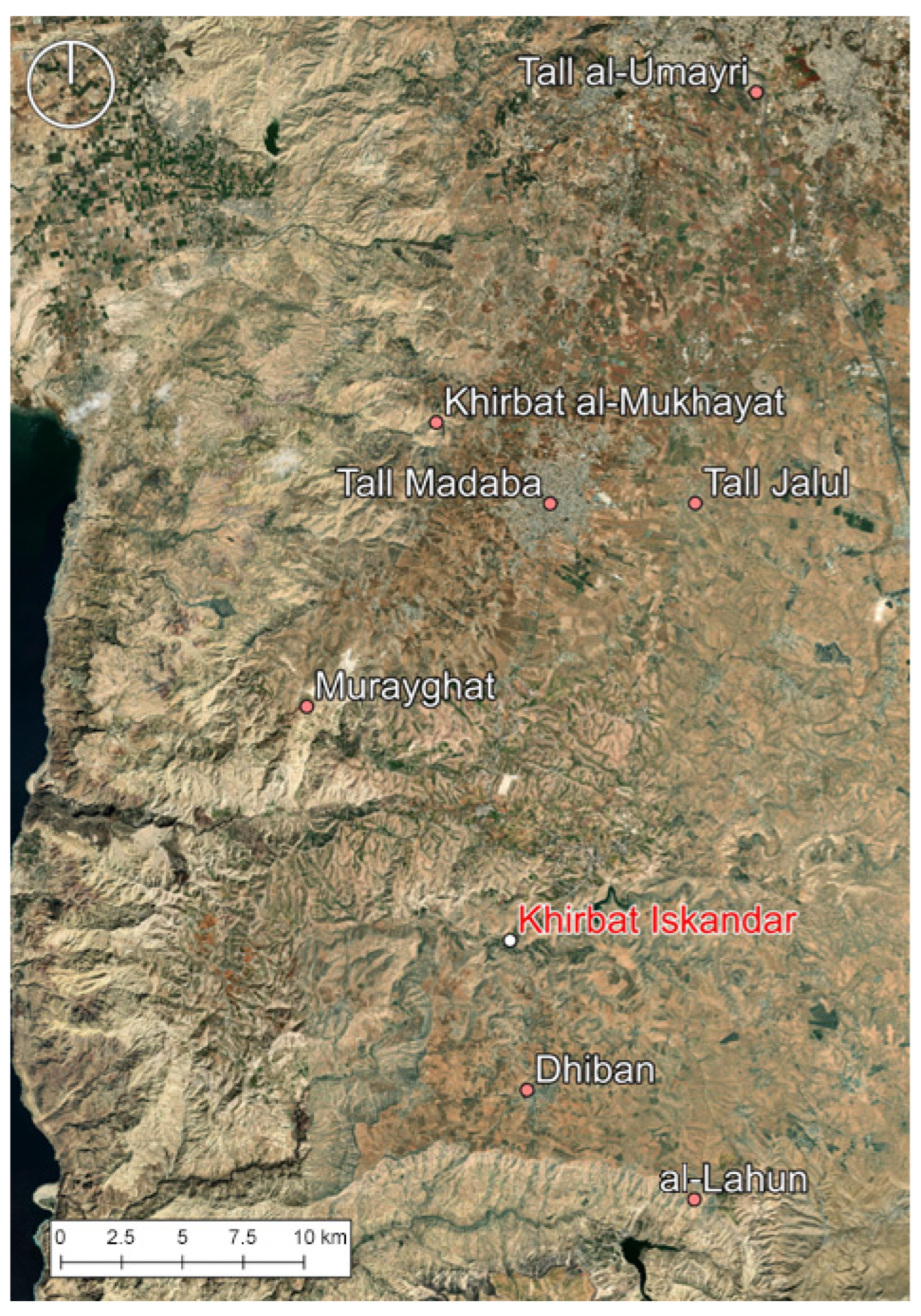
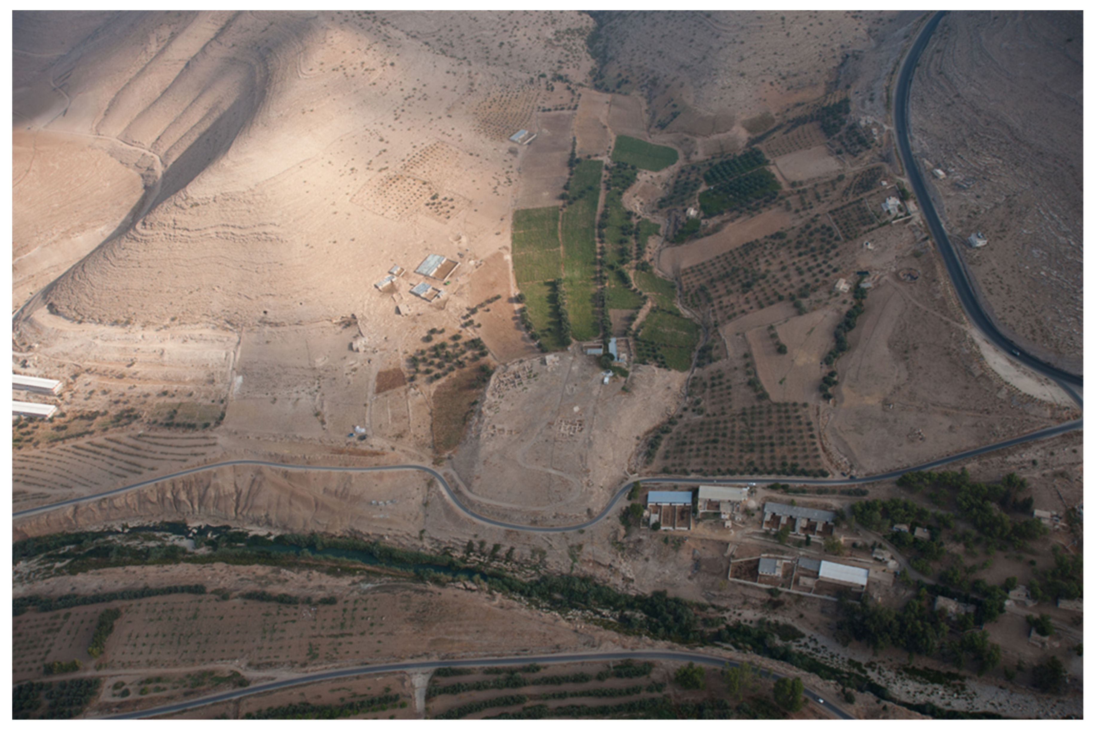
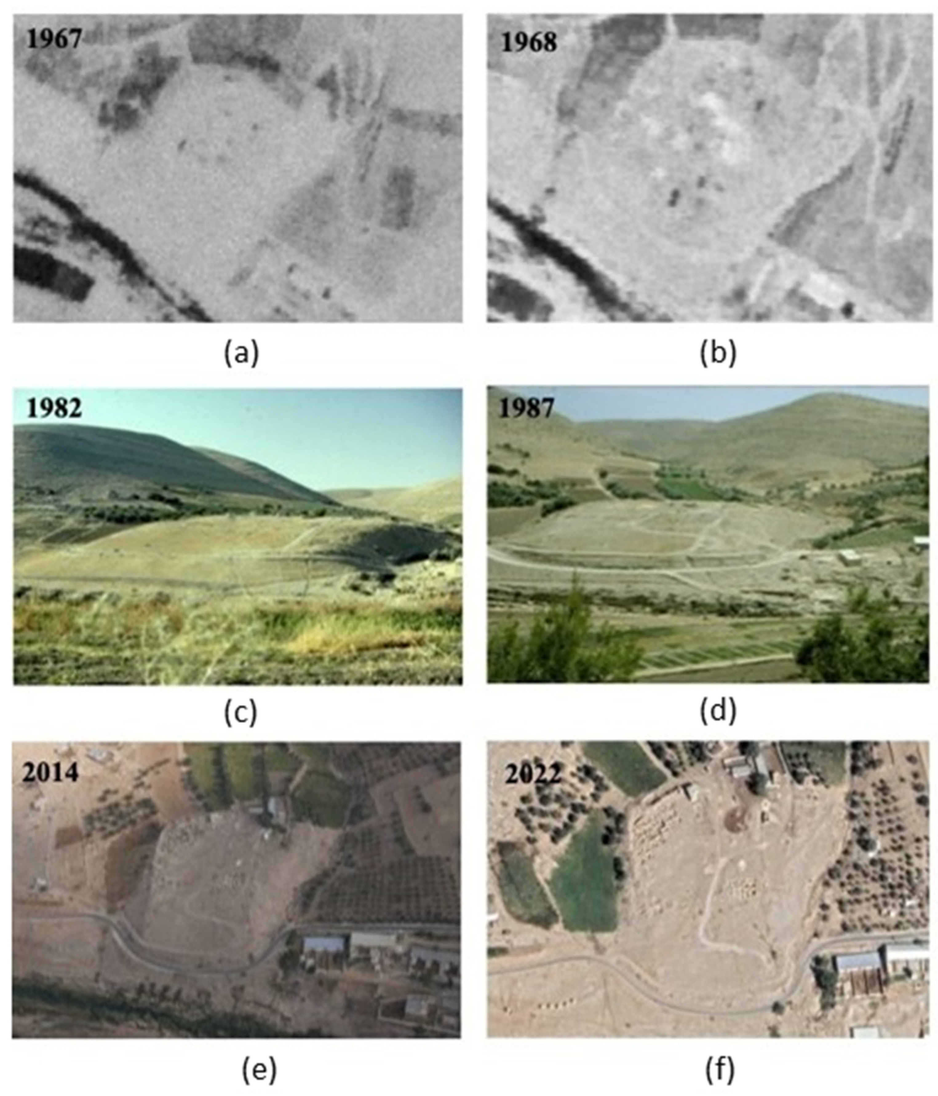
1. Introduction: Archaeology and Cultural Heritage at Khirbat Iskandar

Khirbat Iskandar is an archaeological site in the Madaba Governorate of Jordan (Figure 1), located on a wadi terrace on the northern bank of the Wadi al-Wala and along the King’s Highway, and surrounded by a megalithic cultic and funerary landscape (Figure 2). It is currently being investigated by the Archaeological Expedition to Khirbat Iskandar and Its Environs, started in 1981, which has revealed that it is a signature Early Bronze Age (ca. 3800-1950 BCE) site in Jordan [1,2,3] (citing earlier reports).
Khirbat Iskandar is a tall site, i.e., an artificially mounded site formed by subsequent archaeological deposits, the contour of which is shaped by the presence of buried fortifications (Figure 3). They are a crucial element of the site’s topography through the third millennium BCE, with at least three major rebuilds between ca. 3100/3000 BCE and ca. 2500/2400 BCE, which have been investigated through excavations in the north-western sector of the site ([3] (pp. 356–362) and [4]). This long sequence symbolizes the trajectory of an early urban site that thrived, was destroyed, and survived collapse. This was most likely sustained by its location within an ecological niche where the site’s inhabitants had access to and control over a stretch of fertile agricultural land, a perennial source of water, and a major trade route (Figure 2 and Figure 3).
Archaeological research has shown that the site’s Early Bronze Age occupational sequence spans from the Early Bronze I to the Early Bronze IV, approximately between the mid-fourth millennium BCE through the last centuries of the third millennium BCE. The fine-tuning of the archaeological phasing is still in progress and absolute dating is still awaited for some phases 2022). However, the available data suggest that Khirbat Iskandar developed as one of the earliest fortified urban settlements in Jordan between the Early Bronze I and at least the first half of the Early Bronze III (ca. 3400-2650 BCE, absolute chronology still under revision). Subsequently, following destructions and crises during the later stages of the Early Bronze III (ca. 2650-2500 BCE), it transitioned to a rural village in the Early Bronze IV (ca. 2500-1950 BCE; note that the lower boundary of this interval is conventional). This trajectory includes a fierce devastation most likely brought by a human attack still during the first half of Early Bronze III, two possible earthquake-induced destructions in the later Early Bronze III and in the Early Bronze IV, and abandonment due to environmental degradation toward the close of the third millennium BCE. In fact, geomorphological studies demonstrated that the erosion of the floodplain in the later Early Bronze Age depleted the carrying capacity of the settlement [5]. With this occupational history throughout the fourth and third millennia BCE, Khirbat Iskandar epitomizes the trajectory of one of the major archaeological sites in Jordan along the urban–rural continuum in the protohistoric phases ([6] and [7] (pp. 127–128, 136–176)). For these reasons, there are lessons for the present and the future to learn from the past successes or failures in managing resources sustainably at ancient sites like Khirbat Iskandar. In fact, the site’s trajectory intersects with the development of efficient water and land management strategies, and the subsequent intensification of economic/food production, the consequent price of progress for the environment, generating conflict and abandonments, and resistance to human-brought or natural catastrophes or to climatic and environmental degradation, or collapse.
In modern times, the site’s environs are populated by communities practicing farming and animal herding, which builds a stunning case for connections between past and modern communities because of the reliance on agropastoral subsistence strategies and on the wadi for fresh water. However, like at most protohistoric sites, the archaeological remains at Khirbat Iskandar can be non-intuitive to the eyes of non-experts, which jeopardizes its preservation, exposing it to the threat of damages, even unintentionally, when the cultural/historical/archaeological value of the site is not highlighted. In fact, a certain level of interpretation is necessary to make the protohistoric evidence understandable and more accessible. In this regard, sustainable conservation can—and actually should—be one component in developing efficient ways to present protohistoric sites like Khirbat Iskandar and to enhance their protection.
At Khirbat Iskandar, the southern and south-eastern slopes of the mound have been severely affected by modern construction activities. In particular, two road cuts damaged archaeological assets: an upper dirt road used by modern farmers to travel upward to the hill, where outbuildings for animals and supplies are placed, and a lower paved road running parallel to the Wadi al-Wala and connected to the King’s Highway at a short distance from the site to the east. These two roads clearly cut through the southern edge of the tall site (Figure 3 and Figure 4), and have damaged ancient stratigraphy and architecture and exposed archaeological assets to the threat of decay prior to being documented. For these reasons, in 2023, the Archaeological Expedition to Khirbat Iskandar and Its Environs undertook urgent documentation, consolidation, and stabilization actions to salvage this endangered sector of the site from destruction. In this paper, we present the objectives and results of these activities and discuss the documentation, stabilization, and consolidation actions undertaken in connection with the conceptual/methodological and practical challenges of identifying best practices in the conservation and preservation of antiquities that collapsed prior to being excavated. We finally discuss the potential of these actions for making the significance of the archaeology and cultural heritage at Khirbat Iskandar more accessible to the public, national and international.

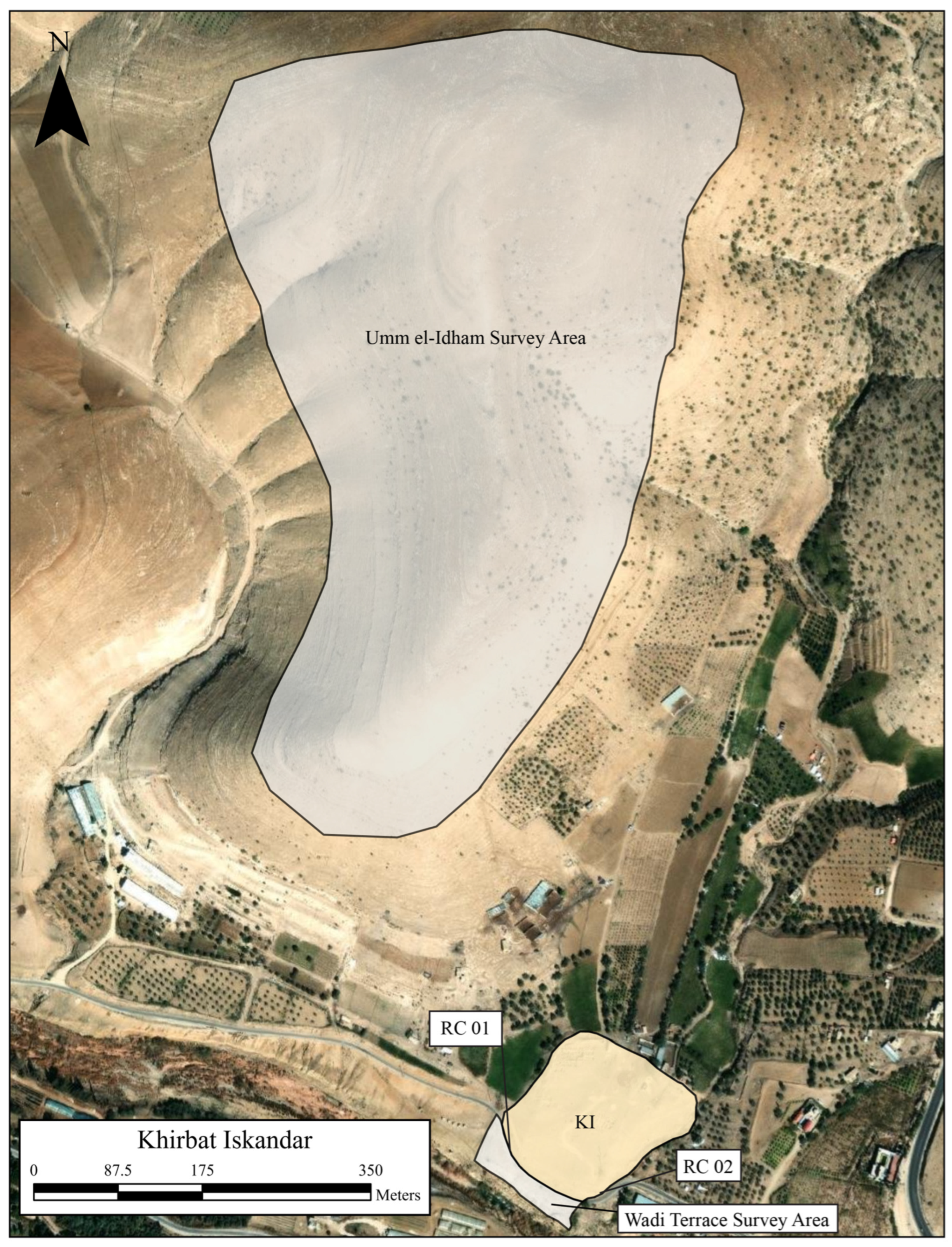
2. The 2023 Season at Khirbat Iskandar: Archaeological Research and Rescue Operations

The actions presented in this article were part of a larger program for the 2023 season at Khirbat Iskandar that pivoted on recording previously undocumented archaeological evidence threatened by anthropic factors (e.g., modern agriculture or construction works, and looting) or natural agents (e.g., erosion, weathering, and decay) in four main sectors (Figure 5). This program included the systematic survey of the hill at Um el-Idham adjacent to Khirbat Iskandar to the north-west, and of the wadi terrace extended to the south of the mounded site, the latter corresponding partially to the southernmost edge of the tall site’s southern slope and in part to the area located outside of the tall site proper. In addition, in the 2023 season, two major operations of stratigraphic trimming and probing were undertaken at the south-western and south-eastern edges of the mound, in the areas named, respectively, Road Cut 01 (KI-RC01) and Road Cut 02 (KI-RC02). These sectors are located where the lower modern paved road has cut through the southern slope of the mound, destroying archaeological assets before they could be recorded; this has made the integrity of this ancient site vulnerable and caused a permanent loss of data and archaeological assets. In fact, the road cut has exposed a ca. 100 m long stratigraphic section with ancient architecture to decay and destruction all along this sector of the site (Figure 6), and a comparison between old and recent views of the tall site shows the impact of erosion on the preservation of the southern slope (Figure 7).
In summary, the entire program for the 2023 season aimed at (1) documenting, salvaging, and protecting endangered cultural heritage, while (2) delineating the footprint of the various settlements that followed one another at Khirbat Iskandar through the Early Bronze Age (in particular, those preceding the Early Bronze IV) and (3) identifying their nature (urban/rural) through time. In addition, (4) a stretch of collapsed Early Bronze Age fortifications in the area, called KI-RC02, was selected for urgent stabilization and consolidation actions. Local cultural authorities in several countries in Western Asia currently encourage the inclusion of consolidation/conservation activities in all project proposals as a means of enhancing their protection and promotion to the benefit of the local and international communities. However, it is also a more general trend to increasingly consider conservation as an essential component of archaeological projects in situ (e.g., [8,9]). The notion that a sharp division between archaeologists and conservation specialists should be superseded by conservation activities taking place during excavation, instead of afterward, has been discussed for long time. It is increasingly accepted that stratigraphic excavations and conservation initiatives should be seen as bonded components of the same enterprise at archaeological sites [10] (p. 5).
Several conferences organized by the International Centre for the Study of the Preservation and Restoration of Cultural Property (ICCROM) have represented a platform that has fueled the international debate on these topics (e.g., [11] (p. 4) and [12] (p. 1)), and the International Council of Monuments and Sites’ (ICOMOS) recommendations provided the theoretical principles and methodological guidelines to follow [13,14].
The case study presented in this article is an excellent example of how rescue operations and consolidation/conservation activities at archaeological sites can be perfectly framed into broader research programs. As we anticipated, such activities may even provide potent tools for communicating the results of archaeological research more efficiently; we shall return to this in the conclusions. The two surveys and the operation at KI-RC01 and the stratigraphy at KI-RC02 will be published in separate reports; in this article, we present and discuss the stabilization and conservation actions undertaken at KI-RC02.

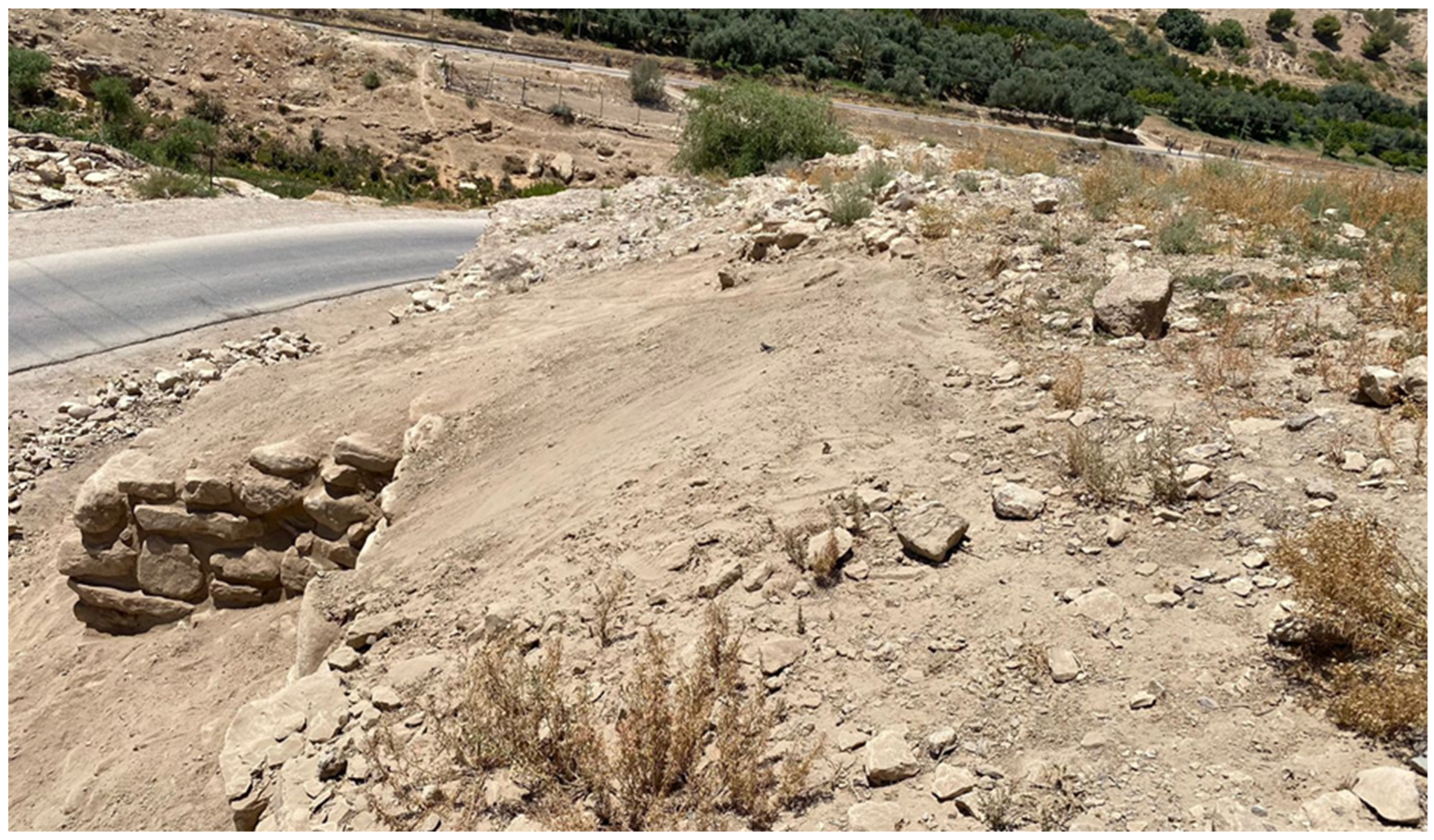
3. Emergency Actions at Khirbat Iskandar—Road Cut 02

The choice of the area that we labelled KI-RC02 for urgent documentation, stabilization, and consolidation was dictated by the presence of exposed and partially collapsed architecture, most likely uncovered by a combination of modern cuts, which were already visible in views of the site from 1987 (Figure 7d), and subsequent erosion and decay. This architecture is a ca. 16 m long stretch of the fortifications that has not been excavated or documented prior to its partial collapse, but is connected to a sector of the fortifications dating from the earlier stages of the Early Bronze III (ca. 2850-2650 BCE). In 1987, this latter sector was subject to preliminary investigation, also in that case following damage caused by modern activities (see the discussion below). As we explain in the following section, this allowed us to carry out some stratigraphic investigations next to the area where the walls were consolidated and in partial connection with the very same architecture that underwent conservation, where possible. In fact, the need for urgent stabilization of the exposed fortifications in these areas prior to their being excavated has faced us with methodological considerations, concerning both the question of safeguarding authenticity [15] and of preventing any further loss of information. Figure 8 charts the workflow of the significant steps of analysis and preservation measures undertaken in the actions reported in this paper.

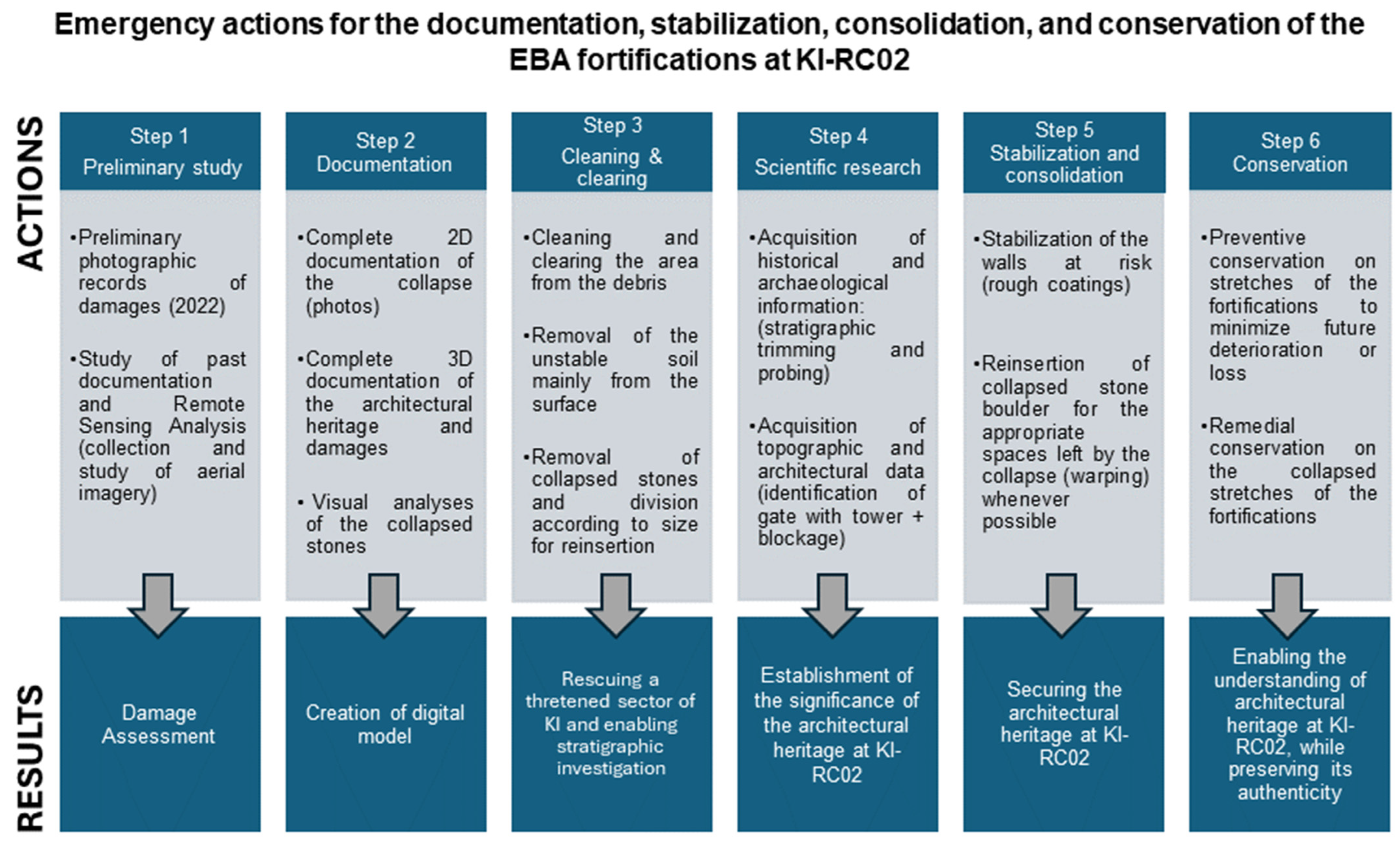
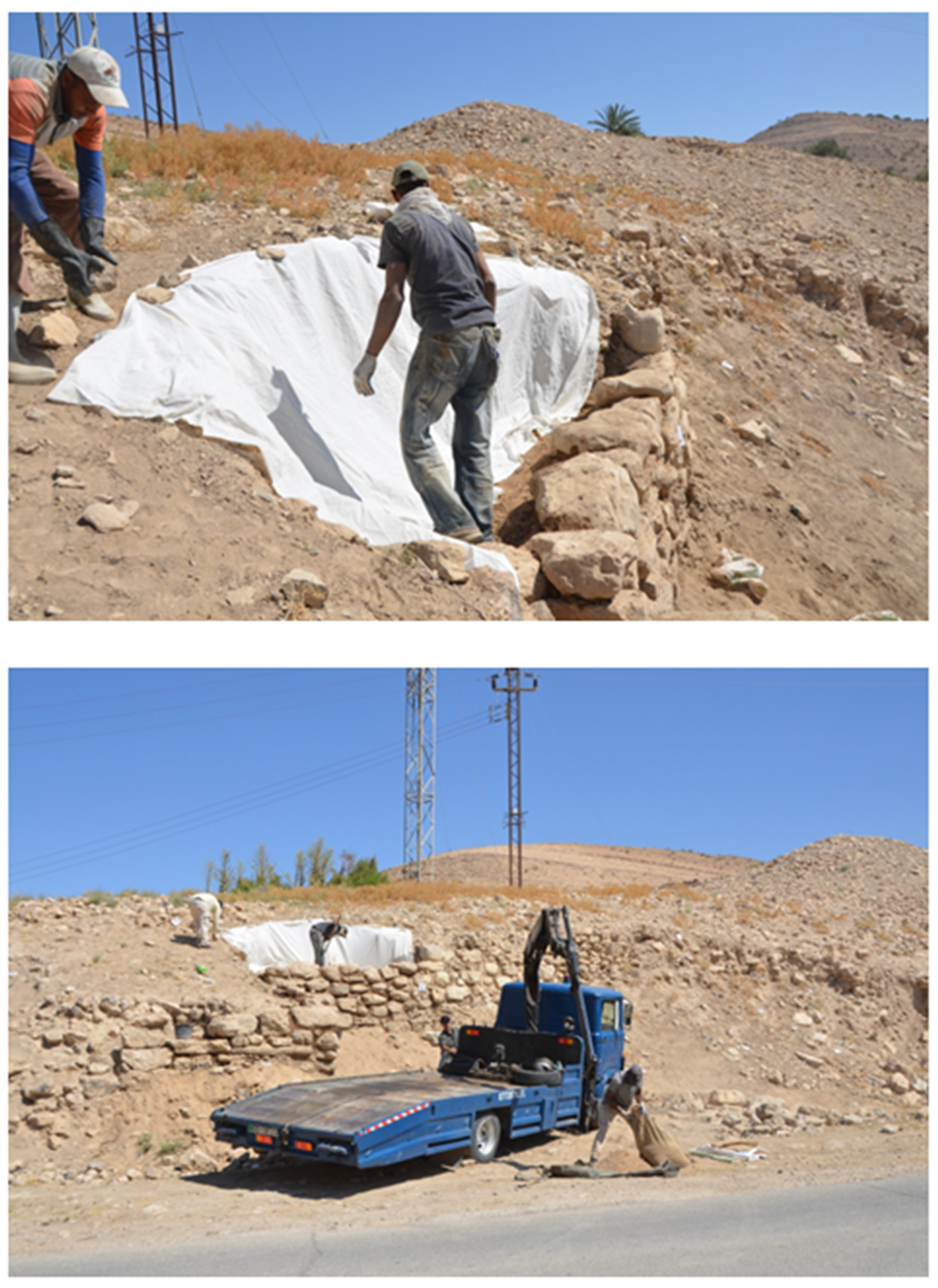
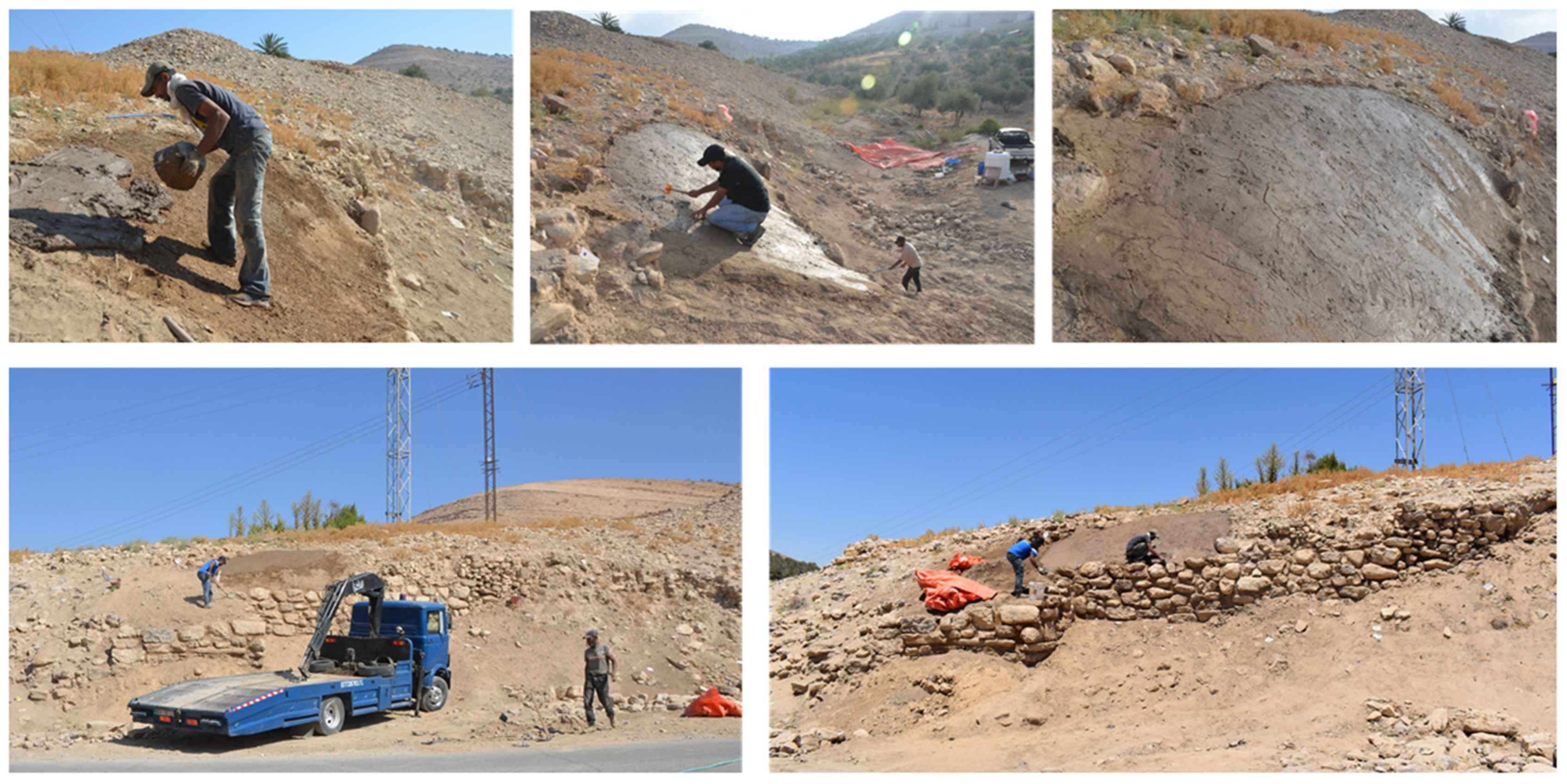
3.1. Preliminary Urgent Documentation Activities

Damages at the site resulting from modern construction works in the area, which in 2023 we labelled KI-RC02, were reported by the Archaeological Expedition to Khirbat Iskandar as early as 1987. Some cleaning, excavation, and documentation activities were carried out in that year at the south-eastern edge of the site, registering the presence of a tower [16] (p. 53, Figure 27; in this paper, Figure 9). In 2022, damages at the southern and south-eastern flanks of the tall site were documented again by the Archaeological Expedition to Khirbat Iskandar [17] (in this paper, Figure 10). This new record was used as a base for a proposal for the 2023 season submitted to the Department of Antiquities of Jordan (DoA) for urgent documentation, consolidation, and stabilization to salvage this endangered sector of Khirbat Iskandar from destruction, with the following specific objectives:
  • To record archaeological evidence already damaged by modern activities;
  • To stabilize archaeological assets already damaged by modern activities in conjunction with natural and environmental factors, and to carry out preventative measures against further collapse and decay to stop the destruction of this sector of the site.
The proposed emergency actions perfectly align with the current requests of the DoA—in particular, for long-term well-established projects—to include major documentation, preservation, consolidation, and restoration components in their proposed activities at archaeological sites in Jordan.
By rechecking the photographs of the ancient architecture exposed by modern construction activities taken in 1987, we clarified that the walls shown on the photos correspond to a blocked gate connected with a rectangular tower (Figure 11 and Figure 12), this latter being part of the area where we undertook major consolidation works in this season. Although it was very difficult to identify the gate on site because of the decay (Figure 11), we were able to locate it and to clarify and demonstrate its connection to a rectangular tower to the east, part of which was consolidated in the 2023 season (see below; Figure 12). We proceeded to a general cleanup of the area between the blocked gate and the stretch of the fortifications to the east of the collapsed wall with the help of local workers, in order to remove the grass and refuse. Following this, we took record shots of the collapsed and damaged architecture before starting any interventions (Figure 13). We then proceeded to the photogrammetric documentation of this sector of Khirbat Iskandar, which allowed us to record the stratigraphic relations between the different interconnecting walls in this area prior to stabilization and consolidation. In particular, the connection between the walls forming the tower to the east—that is, where the most substantial actions for urgent stabilization and consolidation works were undertaken—is clearly visible in our photogrammetric records (Figure 14).

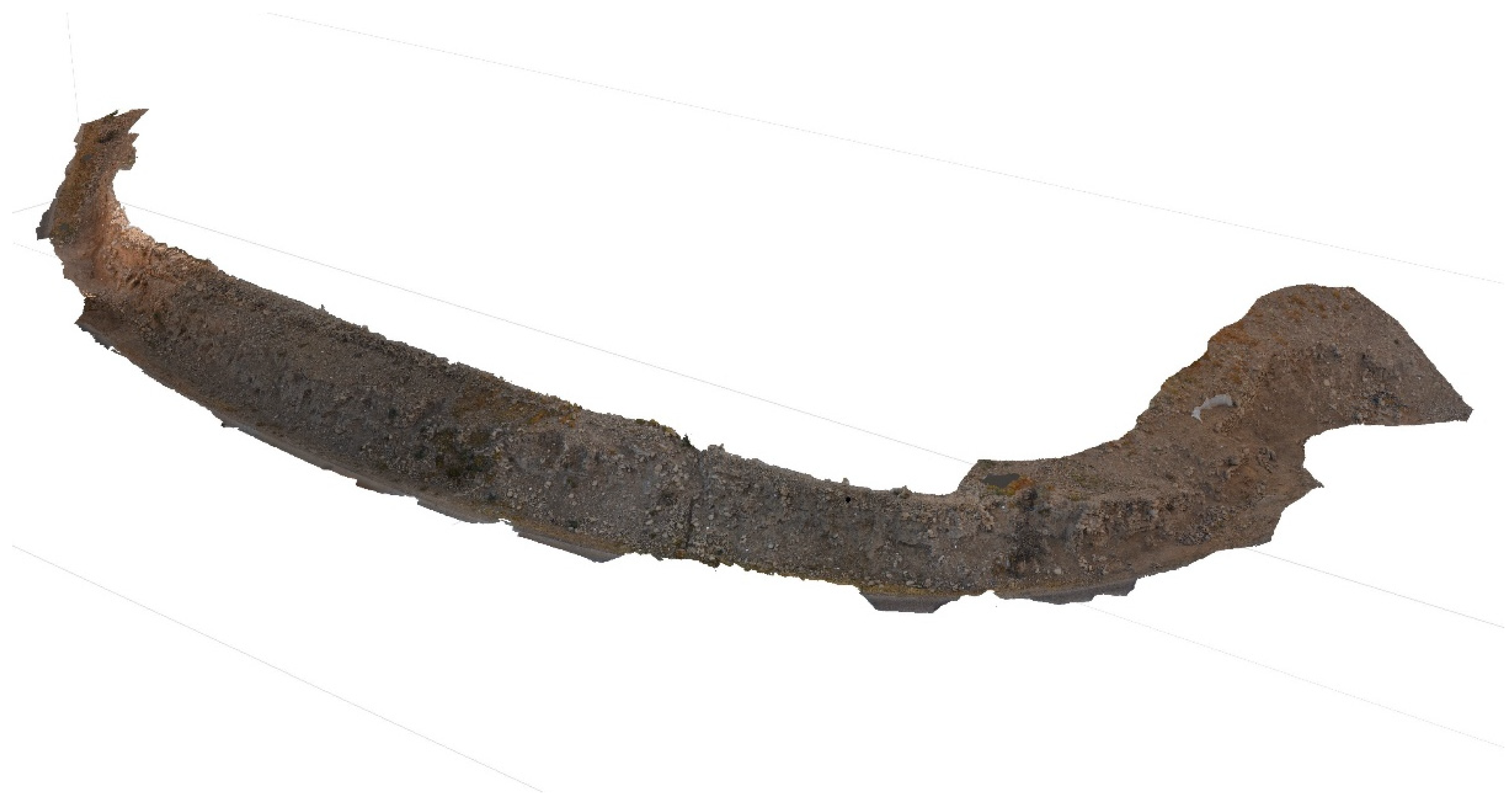
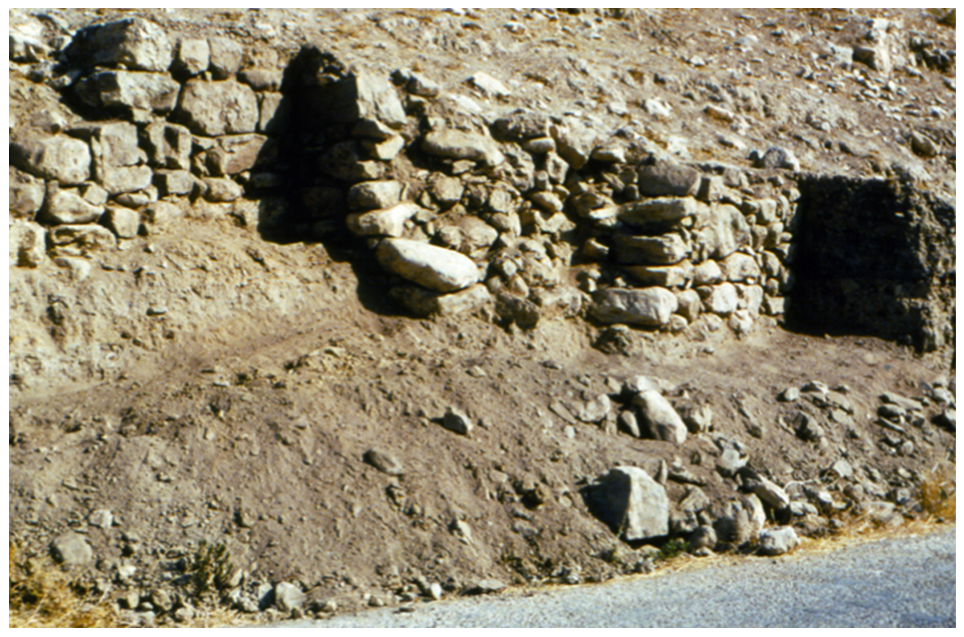
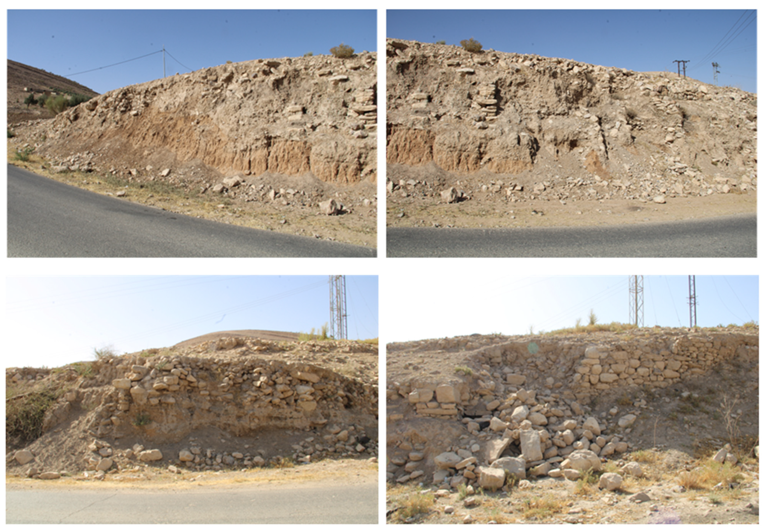
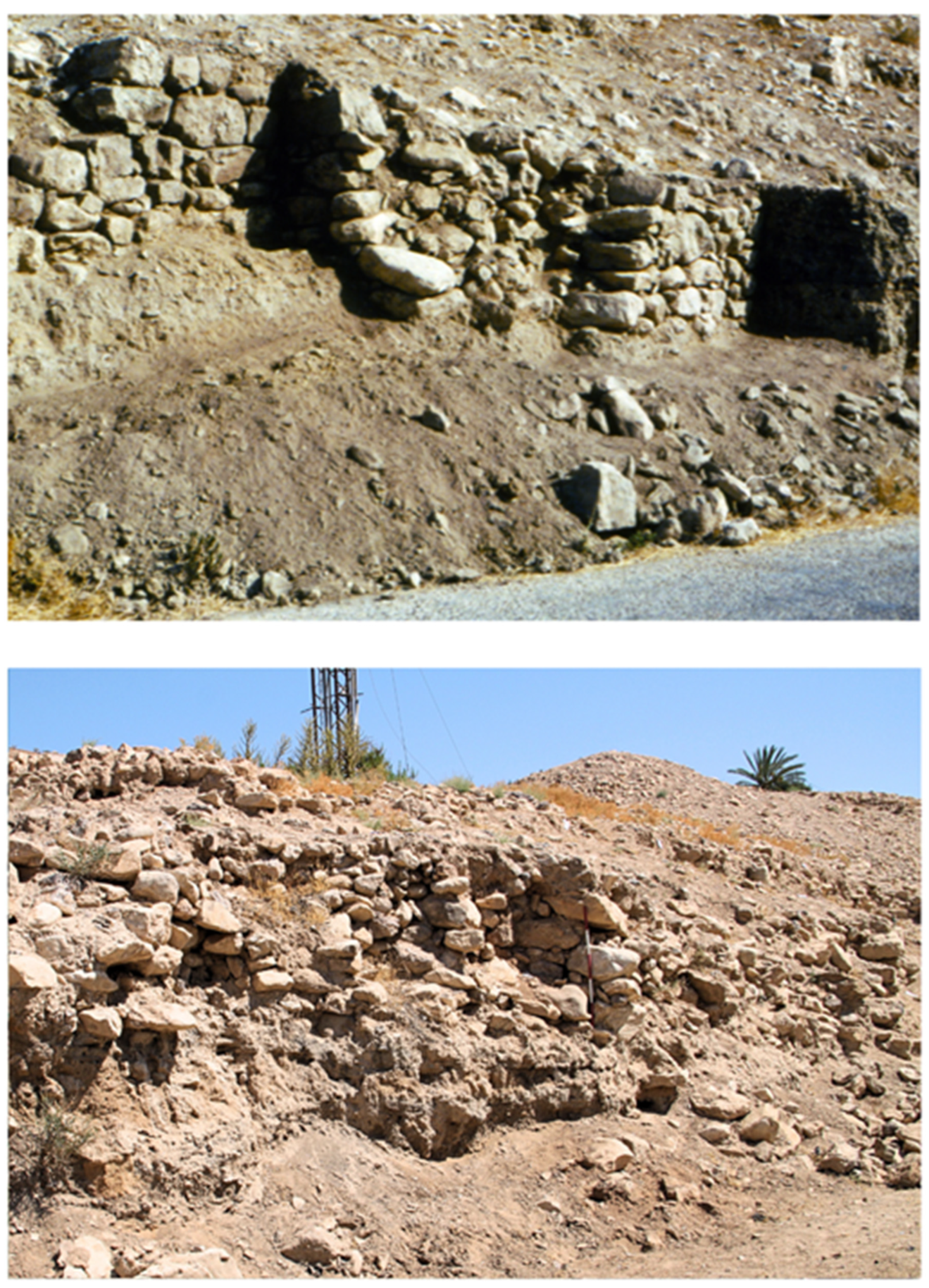
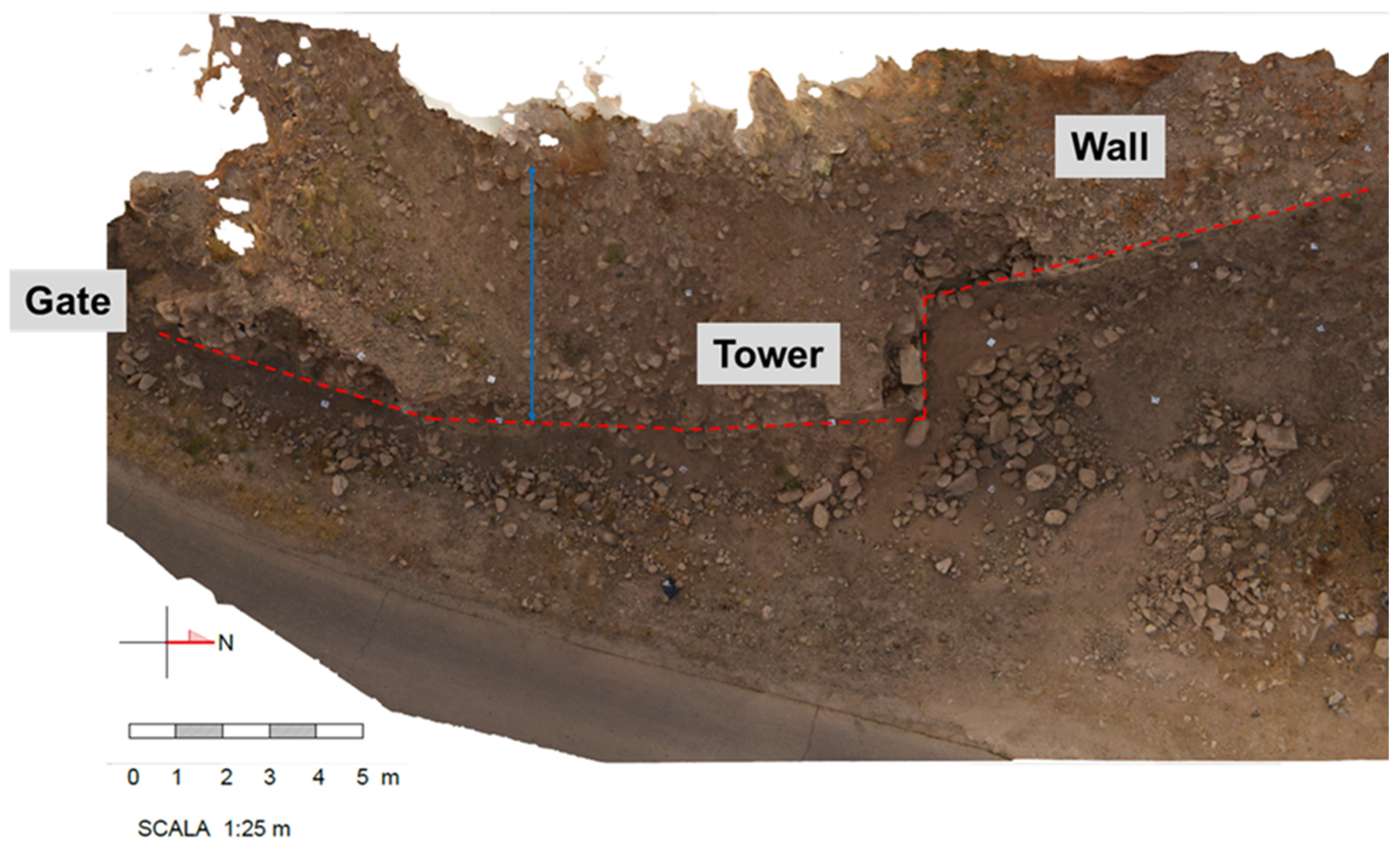
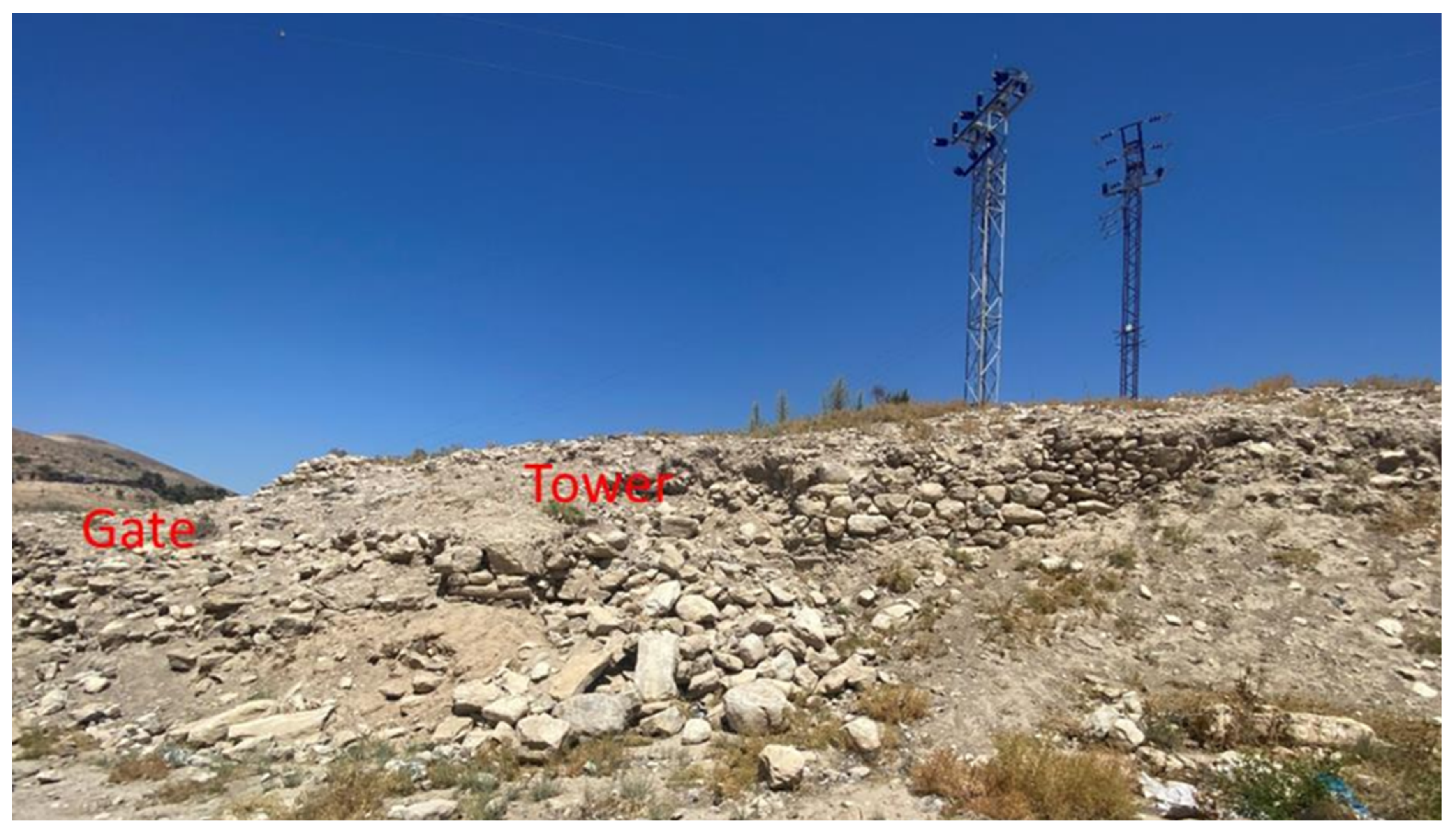
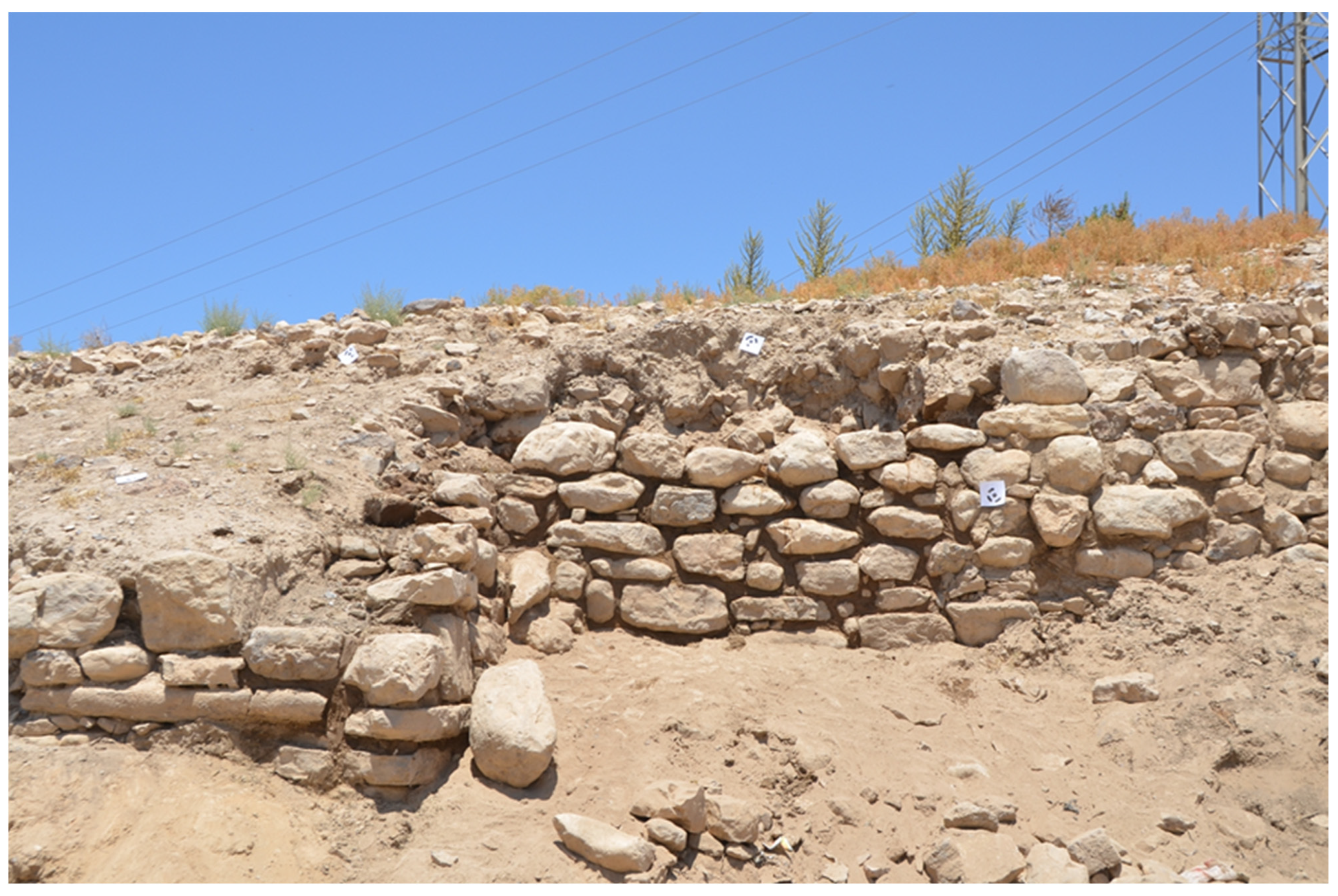
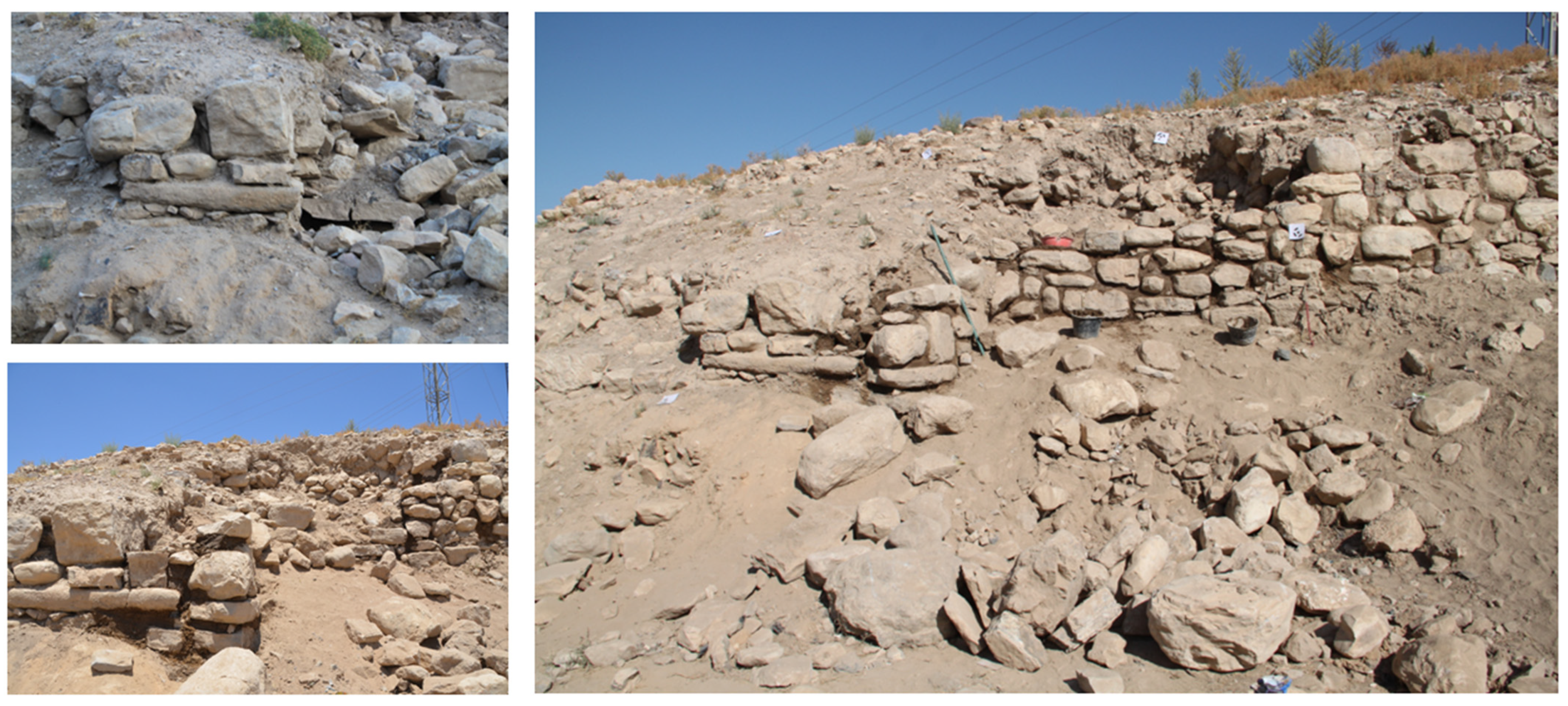
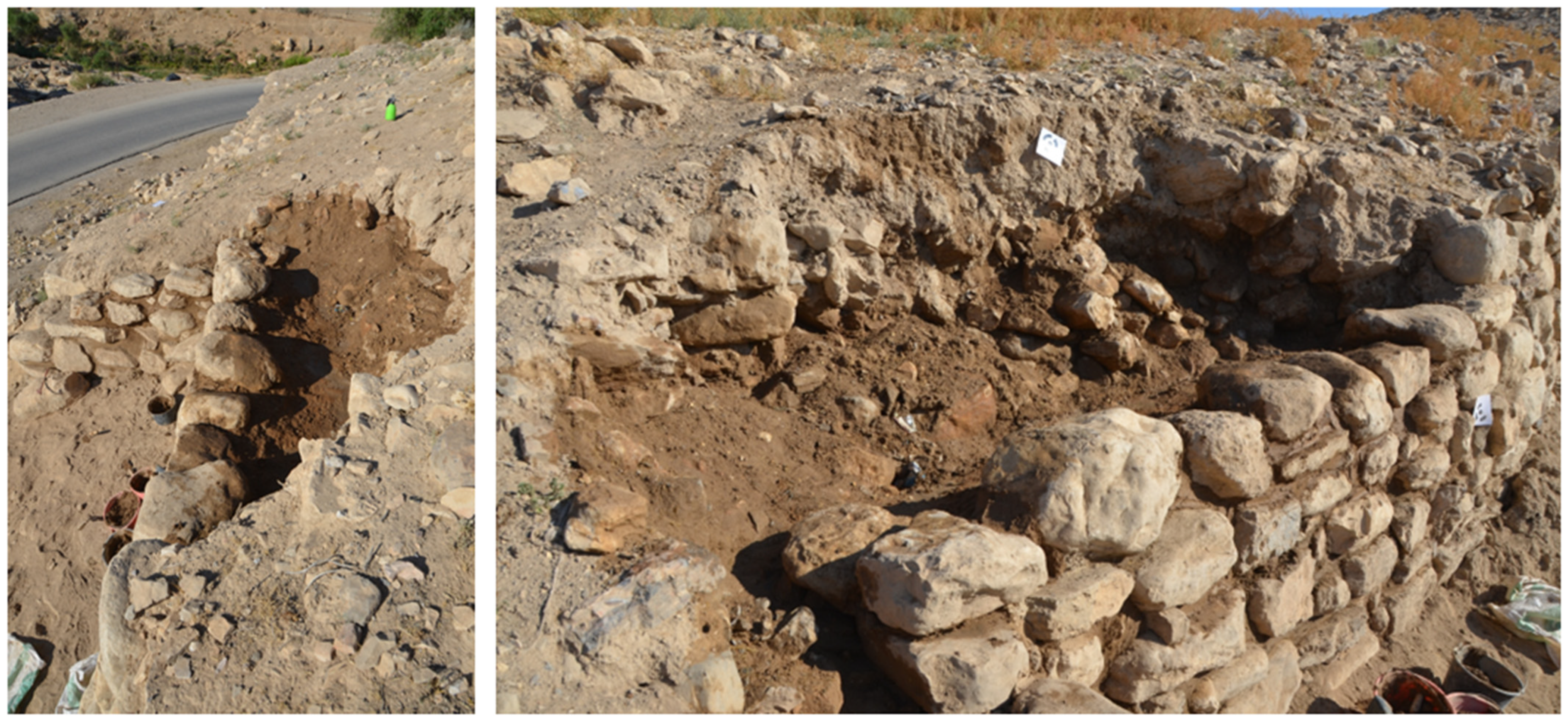
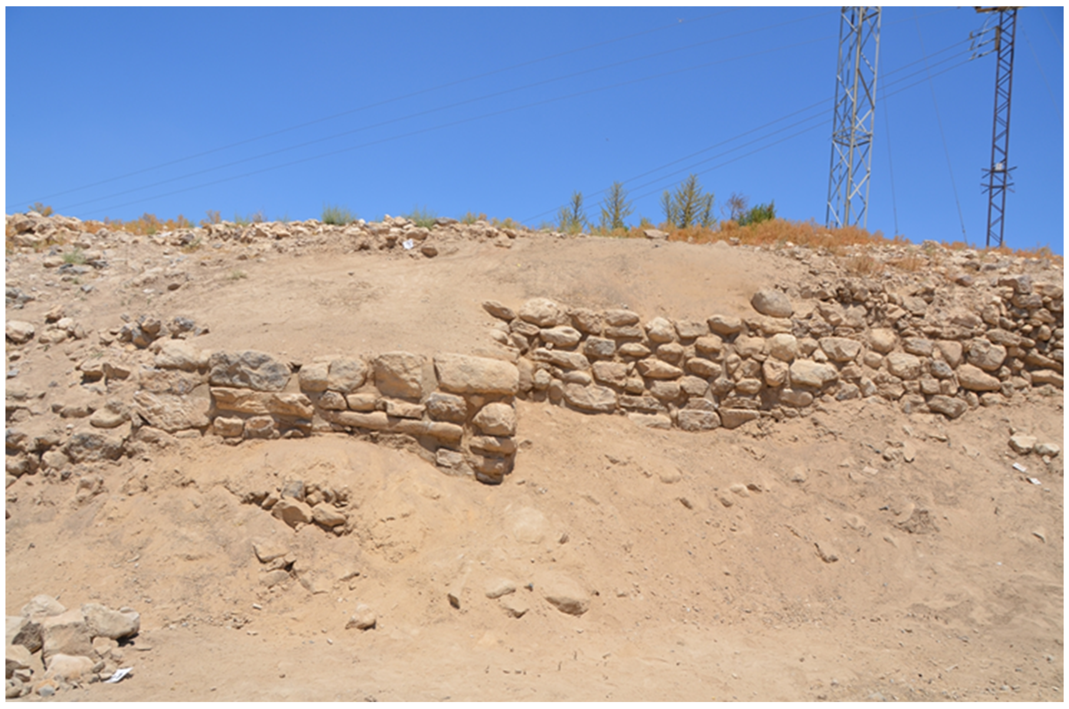
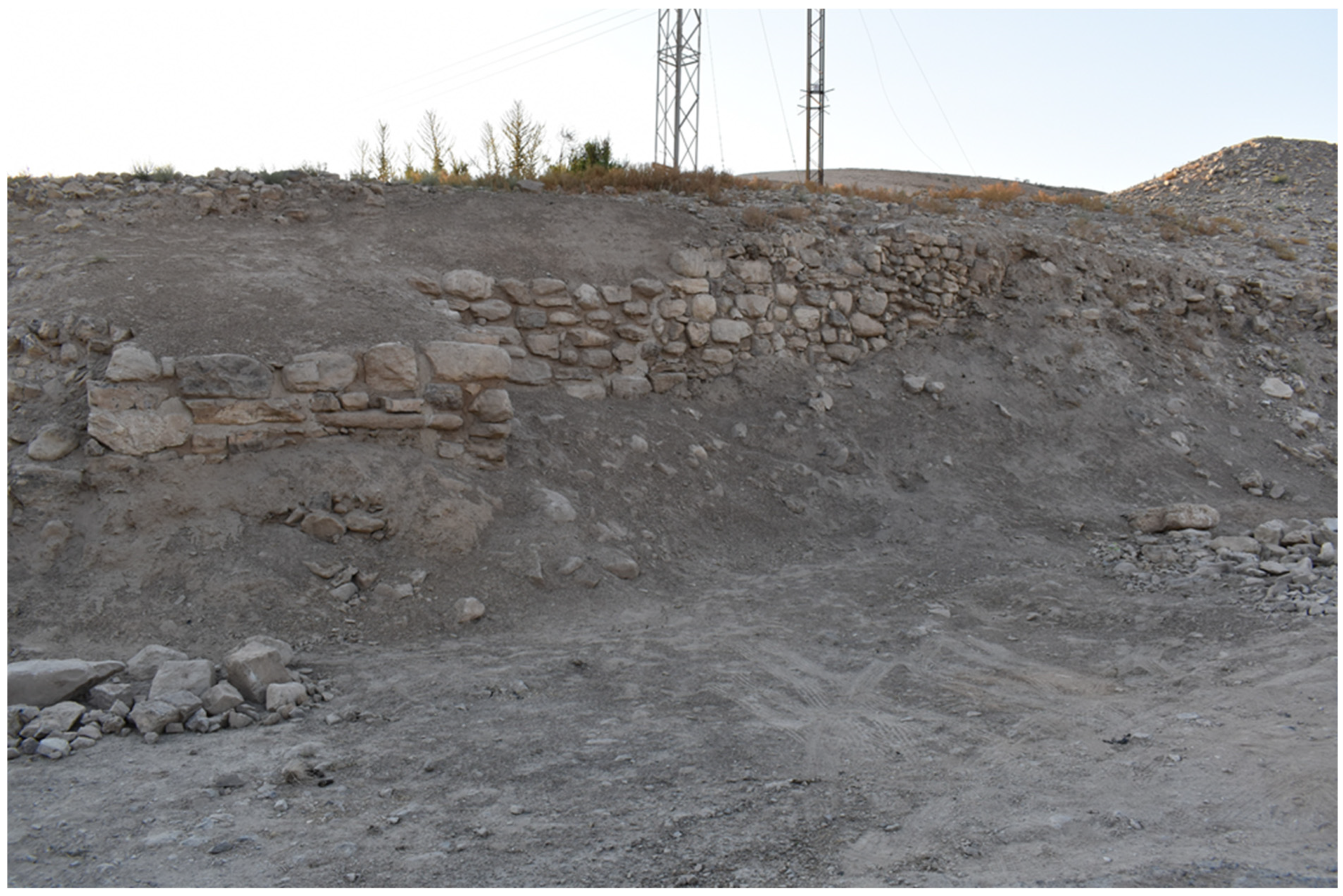
3.2. Emergency Documentation of an Exposed Stratigraphic Section and City Gate by Road Cut 02 at Khirbat Iskandar (KI-RC02)

We established the area for the emergency documentation of stratigraphy and architecture at the blocked gate, georeferenced it in the project’s GIS, cleared the debris from the modern erosion of the section, and removed the backfill from past works. We then proceeded with the stratigraphic trimming of a 2.7 by 2 m sector of the exposed archaeological section and to open a small probe at the bottom of it (Figure 15). These operations produced a thorough record of yet undocumented and severely damaged archaeological assets, threatened by the risk of further destruction, and allowed us to set up research and consolidation objectives for the future seasons. The architecture in this sector of the mound clearly forms part of the stone fortifications that were built and used in the earlier stages of Early Bronze III and that were destroyed before the end of that period (as confirmed by the stratified pottery sherds collected from the destruction layer); this evidence correlates with the destruction uncovered in excavations at virtually all the other sectors of the site (e.g., [17]).
Through stratigraphic trimming, we clarified that the blockage of the gate preceded the destruction of the city, because it was abutted by the thick layer of mudbrick and ash layers that should correspond to the destruction of the earlier Early Bronze III site that most likely happened around 2700 BCE. Whether this means that the permeability of the fortifications was reduced at some point during the first half of the Early Bronze III according to a pattern observed also at other sites in Jordan ([7] (pp. 101–105) and [18] (p. 11)) or that the gate was blocked because of an imminent attack is an open question that needs a broader analysis of the entire fortification system to be answered. However, the stratigraphic trimming and probing allowed us to achieve a stratigraphic profile of this sector and important topographic information, such as the presence of a gate with a tower facing the Wadi al-Wala. These operations were fundamental because they allowed us to obtain substantial chronological information to date the fortifications and about their historical and archaeological meaning before proceeding to stabilize and consolidate the parts that had collapsed, as well as to correlate and synchronize the areas of intervention along the southern slope (KI-RC01 and both sectors at KI-RC02).

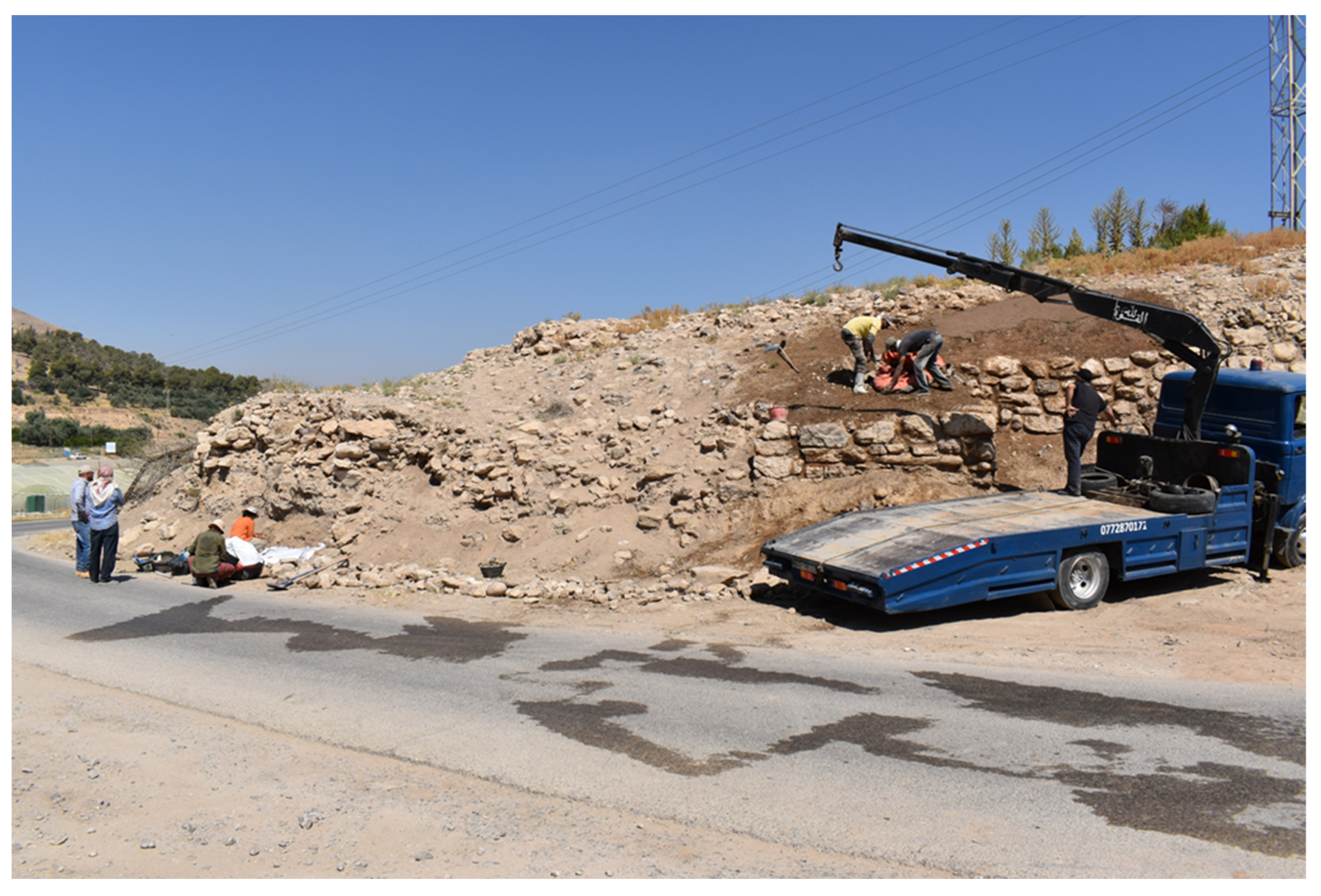
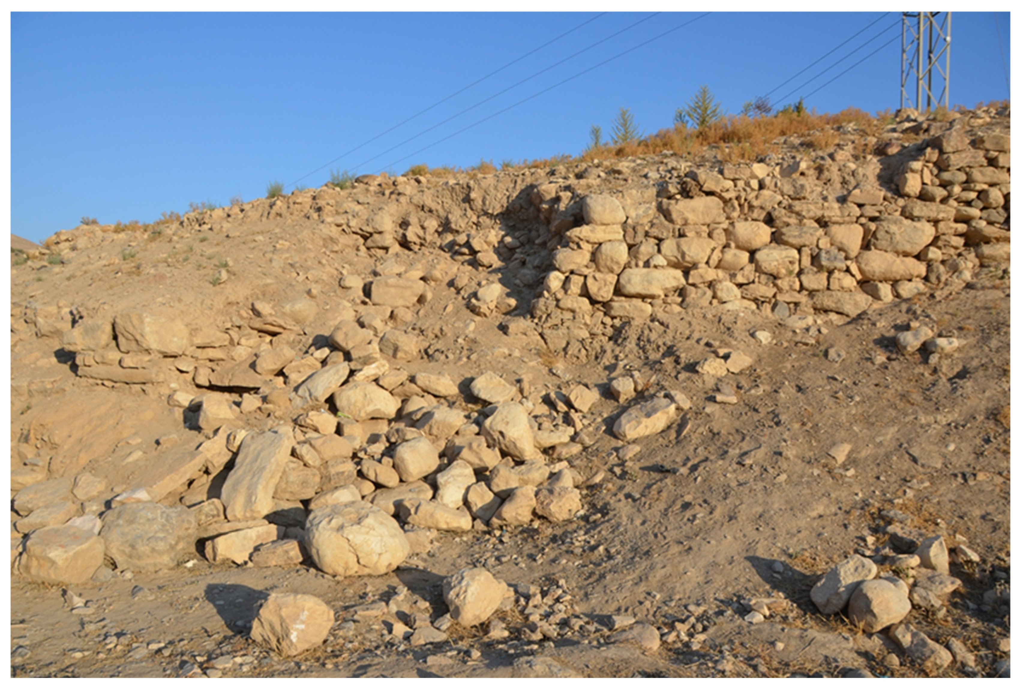
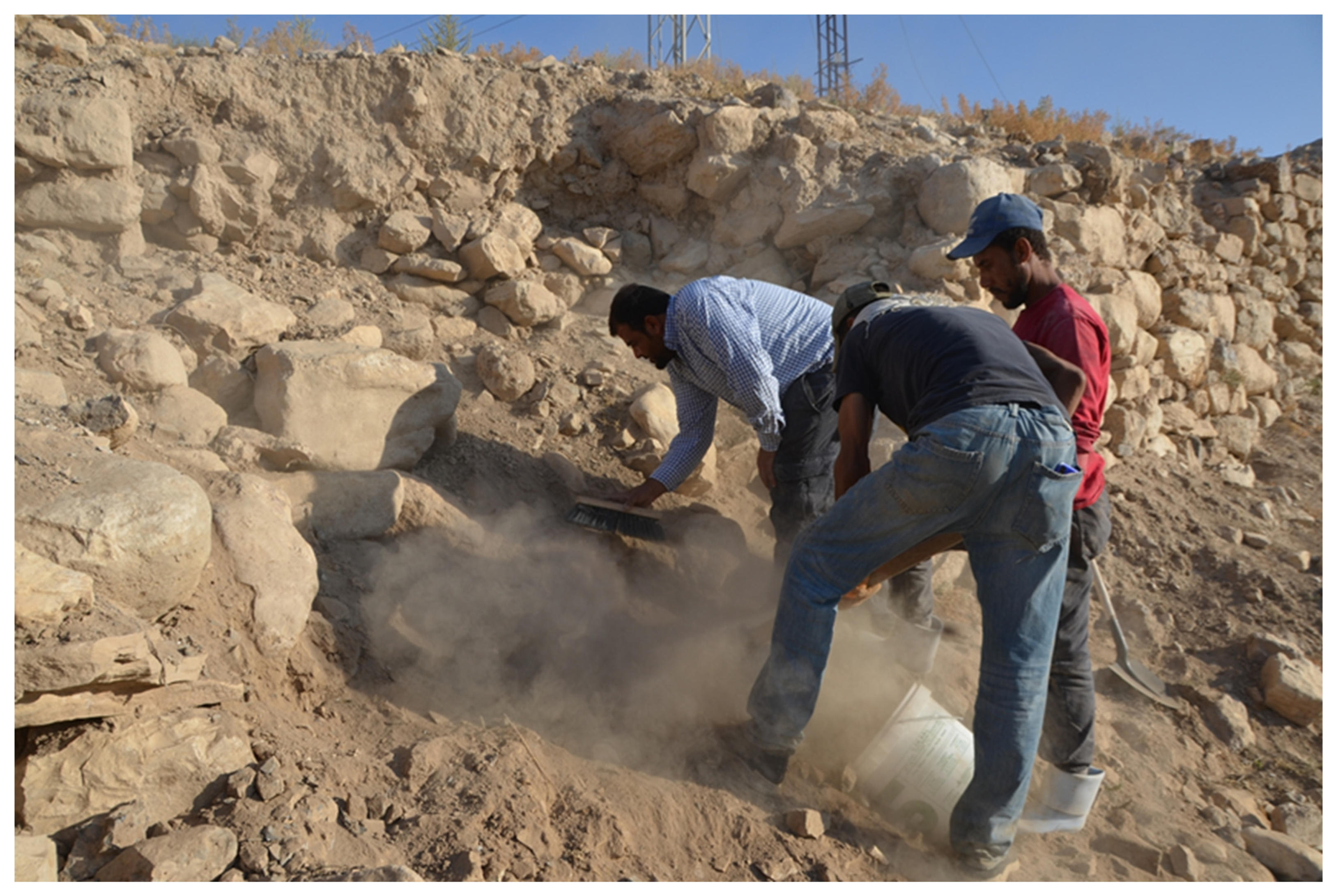
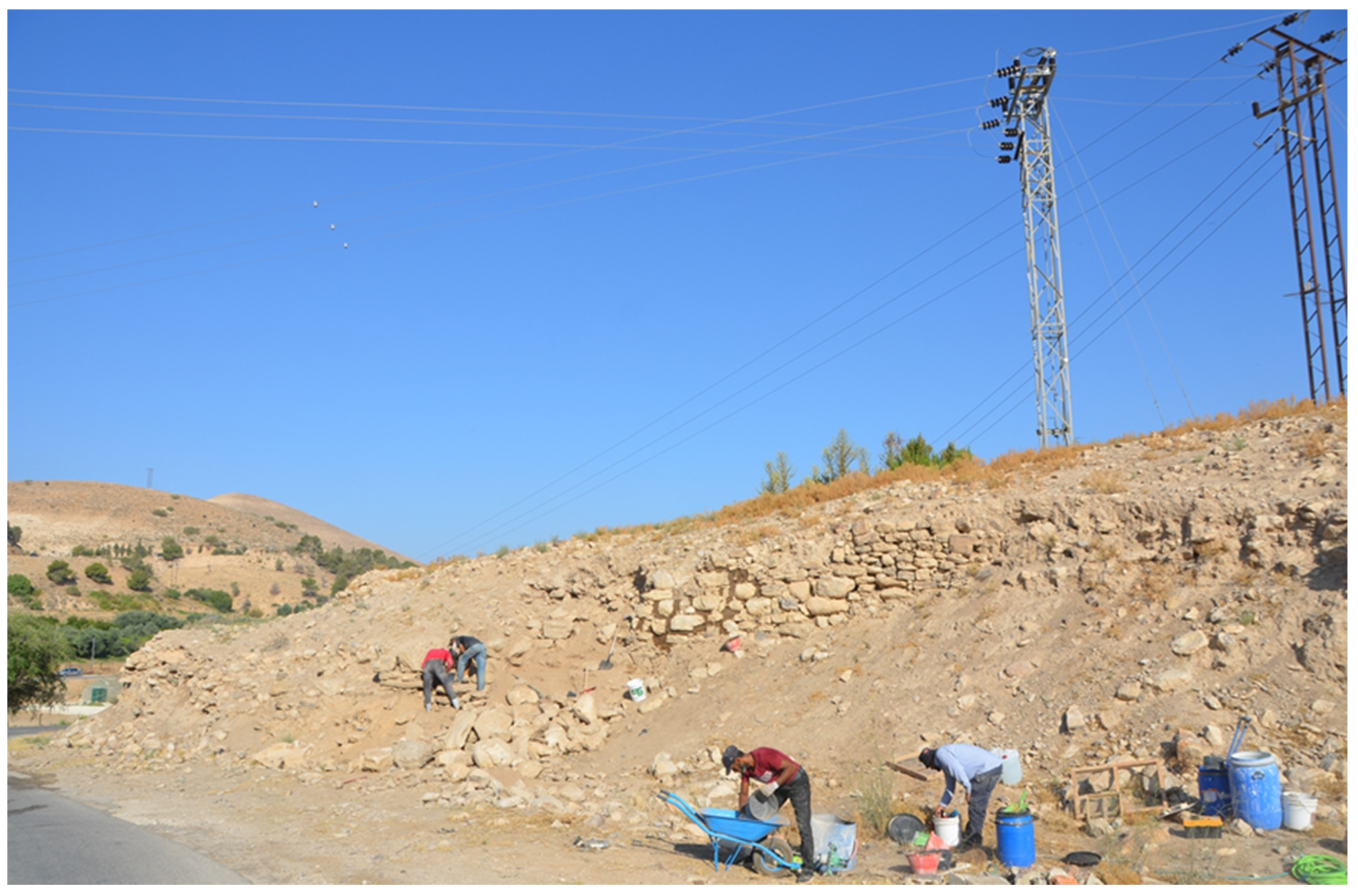
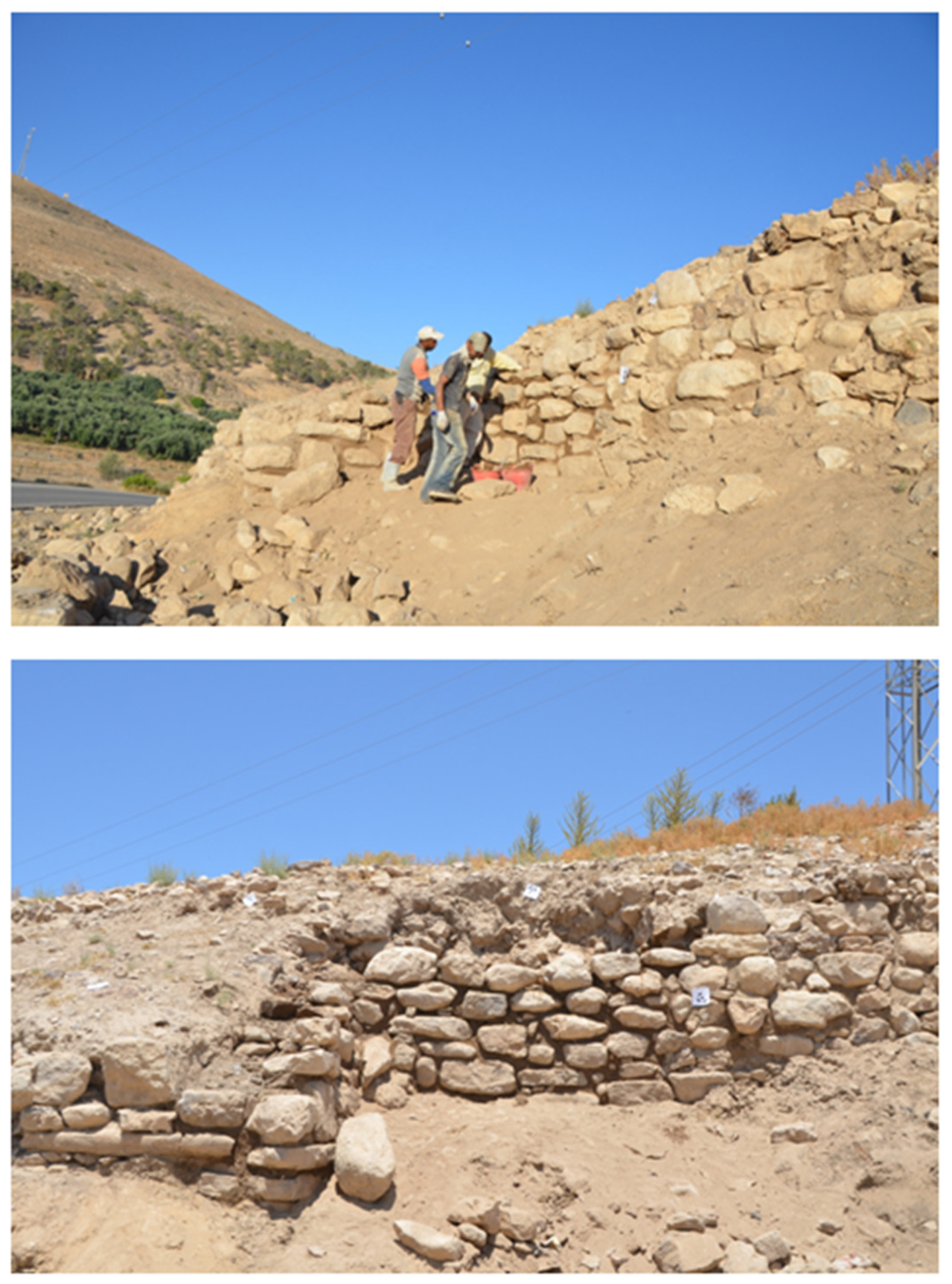
3.3. Emergency Consolidation and Stabilization of the Early Bronze III Collapsed Fortifications at Khirbat Iskandar

East of the area where the stratigraphic trimming was undertaken and the probe was opened, a 16-meter-long stretch of the wall that continues from the gate area and forms a tower with it was exposed by modern construction activities; here, following erosion and weathering, there was some wall collapsed (Figure 11 (bottom), Figure 13 and Figure 16). In this sector, a team of specialized workers coordinated by the project’s restorationist proceeded to clean and clear the area from the debris and, subsequently, to stabilize the architecture at risk and to perform some conservation of the collapsed sections. The materials used in the fortifications are limestone and limestone conglomerates that are naturally available in the surroundings of Khirbat Iskandar. The masonry includes both semi-dressed boulders and undressed stones carefully laid to provide a regular appearance to the exterior face of the wall; rubble was used as chinkstones between the boulder to strengthen the wall cohesion and stability.
The first phase of the work consisted in the removal of the unstable soil mainly from the surface (Figure 17), and then a rough coating of earth was made between the joints of the stones to provide stability to the external parts of the collapsed walls (Figure 18). Thereafter, the various stone blocks from the collapse were removed and divided according to their size and order of reinsertion, for the appropriate spaces left by the collapse (warping). Stone walls in this sector tumbled most likely after the use of mechanical means applied in modern construction activities, which weakened their stability, leading over time to undocumented collapses; however, it was possible to restore the walls, giving to them an appearance that is very close to the original one because part of the stone blocks and associated earthen materials were still on site. In fact, visual analyses of the collapsed stones and their location and of the still standing walls allowed us to reinstate the wall fabric following a methodology that was as close as possible to the original (Figure 19), considering the passage of time from the collapse, erosion, and washout that displaced some of the stones. Whenever possible thanks to a careful analysis of the collapse, the stone boulders were put back exactly where they were originally placed (Figure 20).
The use of a mechanical crane was necessary to move the larger boulders; a plastic tarp was used to protect the stones while moving them. The re-arrangement of the stone blocks took place in stages; the external boulders were re-integrated first and cemented with mud and straw mortar (Figure 21). Subsequently, on the inside, the empty spaces were filled with earth and crushed stone, and this filling at each consecutive level was abundantly wetted, to give it greater stability (Figure 22). Subsequently, a fabric was laid on the inside of the collapsed wall before filling it in order to separate the original from the restored parts, to stabilize the inside, and to regulate water drainage (Figure 23). The inner space above the fabric was afterward filled with earth and stones. Mud, straw, and sifted soil from the other operations were used in the consolidation (which left no dumps from the trimming and probing on site). Once the wall was completely restored, the upper part was leveled so as to protect it and to provide it with some slope that could serve as a means to canalize rainwater and make it flow downstream to avoid water percolations on the face of the walls (Figure 24). Finally, two contour lines made of mortar indicate the limits of the stretch of the walls that underwent conservation and consolidation on the east and west, respectively (Figure 25). In addition, the adjacent eastern stretch of the wall that was still standing was consolidated with mud and straw mortar to prevent future collapse.

4. Results

The urgent stabilization and conservation actions undertaken in KI-RC02 at Khirbat Iskandar were necessary, because the ancient architecture had collapsed in this sector prior to being documented and it was threatened by destruction. These operations align with the current best practices as they meet the “triple R approach” in historic preservation [13,15], because they are recognizable, respectful, and reversible for the reasons summarized below.
(a) They are recognizable because the fabric on the inside and the contour lines made of mortar on the outside mark visibly the beginning and the end of the stretch of the fortifications that underwent stabilization and conservation.
(b) They are respectful because of the nature of the materials used in stabilization and consolidation, which is the same as the original, although the new part can be distinguished from the original.
(c) They are reversible again because of the nature of the materials used, which do not include cement or any other materials that would contrast physically or naturally with the originals, and because the restored part can be dismantled at any time to reach the level to which the originals were preserved.
Finally, they are entirely sustainable, again because of the very nature of the materials used, which do not include chemicals or any other component that can contaminate the soil or water, nor cement.
In addition to all of the above, one of the long-term goals of the Archaeological Expedition to Khirbat Iskandar is to preserve the cultural heritage at the site and to prepare the site for future sustainable touristic development following best practices. Therefore, the actions undertaken in 2023 represent a major first step toward these milestones. Khirbat Iskandar is an extraordinary protohistoric site in Jordan, and the largest third millennium BCE fortified settlement systematically excavated to date in the Madaba region, which, if properly developed for tourism according to best practices and the principles of sustainability, may enrich the touristic offer of the Madaba Governorate. In this regard, to document, stabilize, restore, and protect an extremely endangered sector of the fortifications may also be a way to raise awareness of the importance of the site among the modern local community living and farming around the ancient mound. This would foster its protection in the future by making the knowledge of its importance in the history of the Madaba region more accessible, first and foremost, to the communities living on and around the site’s premises, as well as to local and international visitors. However, comparing the before and after shots of this area (Figure 16 and Figure 26, respectively) clearly shows the visual impact of the 2023 conservation activities, which have already made more intelligible, for visitors coming from the King’s Highway, how the site might have looked in the Early Bronze III. In fact, the stabilization, consolidation, and restoration works at Khirbat Iskandar carried out in 2023 have already made it immediately identifiable as an ancient fortified settlement (Figure 27).

5. Discussion

Descriptions of consolidation or conservation actions undertaken on similar architectures—Early Bronze Age stone wall fortifications—from other sites in Jordan are mostly available as short summaries in longer archaeological reports, or through gray literature. Restoration actions were undertaken, for instance, at Khirbat al-Batrawy, another major Early Bronze II-III site in Jordan, on the Upper Wadi az-Zarqa. At the latter site, the use of rough coatings for the consolidation of the Early Bronze III stone architecture is mentioned in a recent report from 2020 [19]. In the past, major conservation efforts were made at the site of al-Lahun, located 7 km south of Dhiban, which includes major Early Bronze Age remains, comprising the fortifications. The excavator relates that only “soft restoration (including consolidation and conservation)” “in accordance with the Venice charter” was undertaken at the site [20] (p. 227). The use of local materials in these actions is reported too; the mortar used is described as “cement/Suwayliḥ sand/lime/sieved Lāhūn earth in a ration 1:1:2:3” [20] (p. 227). As detailed above, rough coatings were used also at Khirbat Iskandar in the stabilization of the Early Bronze III fortifications; however, the mortar employed in the stabilization/consolidation/conservation activities there, though also made using the sieved soil from the site, was made of mud and straw only. Moreover, the restoration actions undertaken at Khirbat al-Batrawy and al-Lahun can be compared to Khirbat Iskandar because of the nature (and the chronology) of the ancient architecture to restore, but not for the specific case study of restoring unrecorded damaged stone structures discussed in the present paper.
The challenge to restore undocumented collapsed antiquities faced us with methodological issues and theoretical questions concerning conservation. Is it appropriate to stabilize/consolidate ancient architecture that has collapsed prior to being stratigraphically excavated and documented and that is threatened by destruction? What are the best practices for conservation when it is no longer possible to know how a given sector of an ancient monument exactly looked originally? Comparable issues may apply to other contexts, and it is, therefore, worth bringing them up in the debate concerning sustainable conservation strategies. In particular, as we proceeded with a screening of the available scientific literature concerning stone wall consolidation and conservation at archaeological sites, a comparable case of urgent actions on unrecorded damaged architectural evidence could not be found. Given the importance of the Early Bronze III fortifications at Khirbat Iskandar for understanding and showcasing the history, archaeology, and topography of the site, we considered urgent conservation a priority. Therefore, as it is described above, we followed the “triple R approach” and took all measures not to compromise the authenticity of the architectural heritage.
With respect to these issues, it is worth recalling the resolution adopted by ICOM during the 15th Triennial International Council of Museum Committee for Conservation Conference (ICOM-CC) held in New Delhi in 2008 that established the categories of interventions for the conservation of tangible cultural heritage, as reported below from the text of the resolution [21]:
  • “- Preventive conservation—all measures and actions aimed at avoiding and minimizing future deterioration or loss. They are carried out within the context or on the surroundings of an item, but more often a group of items, whatever their age and condition. These measures and actions are indirect; they do not interfere with the materials and structures of the items. They do not modify their appearance.
  • - Remedial conservation—all actions directly applied to an item or a group of items aimed at arresting current damaging processes or reinforcing their structure. These actions are only carried out when the items are in such a fragile condition or deteriorating at such a rate, that they could be lost in a relatively short time. These actions sometimes modify the appearance of the items”.
In the case presented in this article, the team of the Archaeological Expedition to Khirbat Iskandar faced the threat of the permanent loss of undocumented information if the further erosion of the tower had occurred—a comparison between the photos of the adjacent gate taken in 1987 and those from 2023 (Figure 11) effectively shows the rate and degree of degradation induced by erosion following bulldozer cuts in this sector. It was, therefore, necessary to intervene with remedial conservation before more loss and deterioration occurred, while carrying out preventive conservation on the easternmost stretch of the wall that had been exposed but had not yet collapsed. As reported above, the ICOMOS-CC acknowledges that this kind of action may modify the appearance of the assets subject to the interventions [21].
When analyzing issues in conservation at archaeological sites, a critical point is that of rebuilding, which is often aimed at increasing the legibility of the remains, but that can, however, impact their authenticity [10] (p. 1). The ICOMOS Charter on the Principles for the Analysis, Conservation, and Structural Restoration of Architectural Heritage maintains that “Each intervention should, as far as possible, respect the concept, techniques and historical value of the original or earlier states of the structure and leave evidence that can be recognised in the future” [14]. On the other hand, it recognizes that “In archaeological sites specific problems may be posed because structures have to be stabilised during excavation when knowledge is not yet complete. The structural responses to a rediscovered building may be completely different from those to an exposed building. Urgent site-structural-solutions, required to stabilise the structure as it is being excavated, should not compromise the complete buildings concept form and use” [14]. In addition, the ICOMOS International Charter for the Conservation and Restoration of Monuments and Sites (Venice Charter of 1964) indicates that “every means must be taken to facilitate the understanding of the monument and to reveal it without ever distorting its meaning. All reconstruction work should however be ruled out ‘a priori’. Only anastylosis, that is to say, the reassembling of existing but dismembered parts can be permitted. The material used for integration should always be recognizable and its use should be the least that will ensure the conservation of a monument and the reinstatement of its form” [13]. On the one hand, in recent times, what authenticity truly means has been subject to a wide debate and it is increasingly considered as something that cannot be defined “with fixed criteria” [22], and which is dynamic and transformative rather than static, with possible multifaceted meanings that may accrete with time, subject to renegotiation and to historically contingent perceptions and, therefore, representing also a cultural construct [23]. To some extent, this question was already acknowledged by the ICOMOS Nara Document on Authenticity of 1994 [20]. Throughout this text, we refer to the preservation of authenticity as the totality of the measures taken to facilitate the understanding of architectural heritage without distorting their meaning, following Article 15 of the Venice Charter [13]. On the other hand, in recent years, the question of “structural and visual integration” as a response to degradation and loss has received consideration as one of the “most difficult problems encountered in conservation”, clearly because of its connection with authenticity [24]. With respect to this, it has been suggested that form, fabric, and function are basic constructs that define cultural heritage—architectural heritage in the specific case of this article—that should be balanced when considering compensation as a remedy to loss and degradation [24].
In the urgent stabilization and conservation actions undertaken at Khirbat Iskandar in season 2023, we aligned to the principles and guidelines discussed above as concerns the need for integration to be recognizable, the nature of the conservation actions proposed, and the intent of enabling the understanding of the architectural heritage that underwent conservation while preserving its authenticity. Although in the case presented in this paper a philological reading [15] was impossible and a restitution of the eastern façade likewise because it collapsed prior to being documented, we took all measures to minimize the impact of our remedial conservation actions. Therefore, we studied the adjacent preserved stretch of the walls and compared it to the excavated Early Bronze III fortifications in other sectors of the site to reproduce the same building technique with boulders and chinkstones (Figure 19) and used the material from the collapse, which in some cases could be restored to its original position (Figure 18), in the conservation. In this way, our interventions were respectful of the original form, fabric, and function of the restored antiquities. Moreover, the stabilization of the walls in this sector was crucial for preventing further collapse and deterioration that might eventually cause the permanent loss of cultural assets and of historical/archaeological information. In addition, as we mentioned in the previous section, conservation is a means to make cultural heritage accessible to the public at archaeological sites, and the actions undertaken in 2023 have contributed to improve the public understanding of the architectural heritage at Khirbat Iskandar, though still respecting its nature and authenticity as much as possible, as described above.
Finally, the need to undertake urgent actions at the site involving archaeological assets that had not been excavated before made us ponder what would be the best strategies to minimize the loss of archaeological/historical/stratigraphic information, and the risk of contamination of archaeological contexts, if stabilization precedes excavations. With respect to this, laying down the fabric to the level where conservation started will ensure that the mixture between in situ stratigraphy and the materials used in conservation is avoided in the case that future excavations are undertaken in this spot.

6. Conclusions: Presenting Archaeology and Heritage at Khirbat Iskandar

The emergency actions for the documentation, stabilization, and consolidation of the Early Bronze Age fortifications undertaken at Khirbat Iskandar during the 2023 season allowed the expedition team to investigate, record, and protect an important sector of the site damaged by modern activities and by subsequent erosion and decay and, therefore, threatened by destruction. These operations were part of a larger research design to assess the range of occupation outside of the fortifications at Khirbat Iskandar and of a wider program to protect and present the site—one of the most important Early Bronze Age sites in Jordan, and the one with the longest sequence for this time excavated to date in the Madaba region. The stratigraphic investigations carried out with a careful section trimming, the opening of a small but crucial stratigraphic probe, and the analysis of the relationship between the preserved stretches of the walls have added important pieces to our knowledge of Khirbat Iskandar in the Early Bronze III, in particular, as concerns the construction and destruction history and the topography of the fortifications dating from this period.
Significant damages to the walls on the south-eastern edge of the site, and the high risk of further destruction and of an irreversible loss of data and architectural heritage drove the choice of submitting them to conservation prior to excavation in this area. To review, this choice was challenging from methodological and theoretical points of view, but we strictly followed ICOMOS and ICCROM guidelines concerning conservation in order to align to best practices regarding the sustainability of the measures taken to stop the destruction of the archaeological and architectural heritage at Khirbat Iskandar. In particular, thanks to a careful analysis of the architecture and of the stratigraphy, our choices for consolidation and conservation were respectful of the meaning and authenticity of the architectural heritage, and because of the material used, they are also recognizable, reversible, and environmentally sustainable. In this way, our interventions also aligned with ICOMOS Venice Charter’s indication that all measures should be taken to “facilitate the understanding of the monument and to reveal it without ever distorting its meaning” [13]. The stabilization, consolidation, and conservation works undertaken at Khirbat Iskandar in 2023 already changed the perception of the site for the people approaching it from the road, making it immediately intelligible also for non-archaeologists, showing that the current mound is a buried ancient fortified settlement (Figure 26 and Figure 27).
In fact, the significance of the archaeological evidence at protohistoric sites may not be intuitive for the general public; it is, therefore, important to recall that, together with the stabilization/consolidation/conservation activities in the 2023 season, the Archaeological Expedition to Khirbat Iskandar and Its Environs undertook the complete photogrammetric documentation of the entire area driven by the modern road cuts and produced a 3D model. This is certainly excellent for research purposes but also to develop visualization tools for dissemination intents. Therefore, we are currently using the photogrammetric and 3D records obtained in the 2023 season, in conjunction with the continuous study of the architecture and the stratigraphy of the Early Bronze III fortifications, for the following:
  • As a basis to elaborate a Master Plan for the conservation, protection, and sustainable promotion of Khirbat Iskandar to present to the DoA;
  • To use these actions for developing efficient visualization tools to communicate and disseminate the importance of archaeological research at Khirbat Iskandar to a wider audience.
The conjoined traditional stratigraphic archaeology, sustainable and respectful stabilization/consolidation/conservation actions, and complete photogrammetric documentation of the severely damaged and endangered sectors of the site provide the basis for the 3D renderings and visualization tools that we have started to develop as part of the promotion strategies for Khirbat Iskandar. The final objective is to make them available through QR codes on panels designed for the site to illustrate the archaeological remains at Khirbat Iskandar and their significance in creative and engaging ways for the benefit of local and international visitors as a way to facilitate the general understanding of the significance of the archaeological evidence and of the architectural heritage of the site that, as we said, may not be intuitive for non-archaeologists, like at most protohistoric sites.
In summary, we hope that this may provide one example of how meticulous archaeological research onsite and offsite, best practices in conservation actions, and the application of digital technologies for dissemination purposes may create an exemplary model for the sustainable protection and promotion of cultural heritage at archaeological sites where activities that have too often taken place separately would eventually evolve as one enterprise.

Author Contributions

Conceptualization, M.D.; methodology, M.D., S.R., J.C.L.J. and F.S.; writing—original draft preparation, M.D. (Section 1 and Section 2, Section 3.1 and Section 3.2, and Section 4 and Section 5) and F.S. (Section 3.3); writing—review and editing, M.D., S.R., J.C.L.J. and F.S.; visualization, M.D. and F.S.; Supervision, M.D. and S.R.; project administration, M.D. and S.R.; funding acquisition, M.D. and S.R. All authors have read and agreed to the published version of the manuscript.

Funding

This research was funded by a 2023 grant received by Marta D’Andrea from the Italian Ministry of Foreign Affairs and International Cooperation (MAECI) and by funding allocated to Suzanne Richard by Gannon University’s Collins Institute. Financial support to the archaeological and historical investigation of Khirbat Iskandar was provided by Sapienza University of Rome (project “Relazioni urbane/rurali/pastorali nel Levante del III millennio a.C.: Studio multidisciplinare e analisi comparativa”, “Progetti di Ricerca (Piccoli, Medi)—Progetti Medi” 2022, protocol number RM1221816A7DC87B).

Data Availability Statement

The data presented in this study are available upon request from the corresponding author. The data are not publicly available due to copyright reasons.

Conflicts of Interest

The authors declare no conflicts of interest.

References

  1. Richard, S.; Long, J.C., Jr.; Holdorf, P.; Peterman, G. (Eds.) Khirbat Iskandar Final Report on the Early Bronze IV Area C “Gateway” and Cemeteries; The American Schools of Oriental Research Archaeological Report Series 14; Archaeological Expedition to Khirbat Iskandar and Its Environs//The American Schools of Oriental Research: Boston, MA, USA, 2010; Volume 1. [Google Scholar]
  2. D’Andrea, M.; Long, J.C., Jr.; Richard, S. New Insights about the Early Bronze Age Sequence at Khirbat Iskandar: The 2016 Excavations. In Studies in the History and Archaeology of Jordan XIV. Culture in Crisis Flows of People Artifacts, and Ideas, Proceedings of the 14th International Conference on the History and Archaeology of Jordan, Florence, Italy, 21–25 January 2019; Balawi, F., Creasman, P.P., Eds.; Part I; Department of Antiquities of Jordan: Amman, Jordan, 2022; pp. 224–249. [Google Scholar]
  3. Richard, S.; Long, J.C., Jr.; D’Andrea, M. Expedition to Khirbat Iskandar and Its Environs: The 2019 Season. Hawiliyyat Da’irat Al-Atar Al-‘Amm. (Annu. Dep. Antiq. Jordan) 2023, 61, 349–364. [Google Scholar]
  4. Richard, S. Recent Excavations at Khirbat Iskandar, Jordan. The EB III/IV Fortifications. In Proceedings of the 9th International Congress on the Archaeology of the Ancient Near East, Basel, Switzerland, 9–13 June 2014; Kaelin, H., Mathys, H.-P., Eds.; Volume 3: Reports. University of Basel; Harrassowitz Verlag: Wiesbaden, Germany, 2016; pp. 585–597. [Google Scholar]
  5. Cordova, C.E. Floodplain degradation and settlement history in Wadi al-Wala and Wadi ash-Shallalah, Jordan. Geomorphology 2008, 101, 443–457. [Google Scholar] [CrossRef]
  6. Cohen, S. Continuity, Innovation, and Change. The Intermediate Bronze Age in the Southern Levant. In The Social Archaeology of the Levant. From Prehistory to the Present; Yasur-Landau, A., Cline, E.H., Rowan, Y., Eds.; Cambridge University Press: Cambridge, UK, 2018; pp. 183–198. [Google Scholar]
  7. Greenberg, R. The Archaeology of the Bronze Age Levant: From Urban Origins to the Demise of City-States, 3700–1000 BCE (Cambridge World Archaeology); Cambridge University Press: Cambridge, UK, 2019. [Google Scholar]
  8. Nardi, R. Conservation, Restoration, and Preservation in Classical Archaeology. In Encyclopedia of Global Archaeology; Smith, C., Ed.; Springer: New York, NY, USA, 2014; pp. 1666–1674. [Google Scholar]
  9. Sassu, M.; Zarins, J.; Giresini, L.; Newton, L. The ‘Triple R’ Approach on the Restoration of Archaeological Dry Stone City Walls: Procedures and Application to a UNESCO World Heritage Site in Oman. Conserv. Manag. Archaeol. Sites 2017, 19, 106–125. [Google Scholar] [CrossRef]
  10. Matero, F.G. Heritage, Conservation, and Archaeology: An Introduction, AIA Site Preservation Program. pp. 1–5. 2008. Available online: https://www.archaeological.org/pdfs/Matero.pdf (accessed on 29 January 2024).
  11. Melucco, A. Archéologie de fouille et conservation: Limites et domaine d’intervention, respectivement de l’archéologue et du restaurateur. In Preventive Measures during Excavations and Site Protection/Mesures Préventives en Course de Fouilles et Protection du site. Conference. Gand, 6–8 novembre 1985; ICCROM: Roma, Italy, 1986; pp. 1–12. [Google Scholar]
  12. Stanley Price, P. Excavation and Conservation. In Conservation on Archaeological Excavations. With Particular Reference to the Mediterranean Area; Stanley Price, P., Ed.; ICCROM: Roma, Italy, 1995; pp. 1–10. [Google Scholar]
  13. ICOMOS International Charter for the Conservation and Restoration of Monuments and Sites (The Venice Charter 1964). Available online: https://www.icomos.org/images/DOCUMENTS/Charters/venice_e.pdf (accessed on 28 January 2024).
  14. ICOMOS Principles for the Analysis, Conservation and Structural Restoration of Architectural Heritage. 2003. Available online: https://www.icomos.org/en/about-the-centre/179-articles-en-francais/ressources/charters-and-standards/165-icomos-charter-principles-for-the-analysis-conservation-and-structural-restoration-of-architectural-heritage (accessed on 28 January 2024).
  15. Brandi, C. Theory of Restoration, I. In Historical and Philosophical Issues in the Conservation of Cultural Heritage; Stanley Price, N., Talley, M.K., Jr., Vaccaro, A.M., Eds.; The Getty Conservation Institute: Los Angeles, CA, USA, 1996; pp. 230–235. [Google Scholar]
  16. Richard, S. The 1987 Expedition to Khirbet Iskander and Its Vicinity: Fourth Preliminary Report. In Preliminary Reports of ASOR-Sponsored Excavations 1983-87 (Bulletin of the American Schools of Oriental Research. Supplementary Studies 26); Rast, W.E., Ed.; The American Schools of Oriental Research: Baltimore, MD, USA, 1990; pp. 33–58. [Google Scholar]
  17. D’Andrea, M.; Richard, S. Missione Archeologica a Khirbat Iskandar, Giordania: Risultati recenti e obiettivi futuri. In Egitto e Vicino Oriente Antico tra Passato e Futuro. Atti del Terzo Convegno EVOA, Roma 30 giugno–1 luglio 2022; Cereti, C.G., Ed.; Scienze dell’Antichità 29.3: Roma, Italy, 2023; pp. 95–106. [Google Scholar]
  18. Douglas, K. Beyond the City Walls: Life Activities Outside the City Gates in the Early Bronze Age in Jordan: Evidence from Khirbet ez-Zeraqon. In Daily Life, Materiality, and Complexity in Early Urban Communities of the Southern Levant: Papers in Honor of Walter E. Rast and R. Thomas Schaub; Chesson, M.S., Ed.; Penn State University Press: University Park, PA, USA, 2011; pp. 3–22. [Google Scholar] [CrossRef]
  19. Nigro, L. Preliminary Report on the 16th Season (2020) of Archaeological Investigations and Restorations at Khirbet Al-Batrawy by Rome «La Sapienza» University. «Urban Origins in the Wadi Az-Zarqa: The Case of Khirbat AL-Batrāwī». Available online: https://www.lasapienzatojordan.it/Season.php?Res=2020 (accessed on 18 March 2023).
  20. Homès-Fredericq, D. Protection and Promotion of the Archaeological Site of al-Lāhūn: A Technical Study. In Studies in the History and Archaeology of Jordan 11; Department of Antiquities of Jordan: Amman, Jordan, 2013; pp. 221–230. [Google Scholar]
  21. ICOM-CC Terminology to Characterize the Conservation of Tangible Cultural Heritage. Resolution adopted by the ICOM-CC membership at the 15th Triennial Conference, New Delhi, 22–26 September 2008. Published Online on 11 December 2009. Available online: https://www.icom-cc.org/en/downloads/icom-cc-resolution-terminology-english (accessed on 28 January 2024).
  22. ICOMOS The Nara Document on Authenticity (1994). Available online: https://www.icomos.org/en/charters-and-texts/179-articles-en-francais/ressources/charters-and-standards/386-the-nara-document-on-authenticity-1994 (accessed on 29 January 2024).
  23. Silverman, H. Heritage Authenticity. In The Palgrave Handbook of Contemporary Heritage Research; Waterton, E., Watson, S., Eds.; Palgrave MacMillan: Houndmills, UK; New York, NY, USA, 2015; pp. 69–88. [Google Scholar]
  24. Matero, F. Loss, Compensation and Authenticity in Architectural Conservation. J. Archit. Conserv. 2006, 12, 71–90. [Google Scholar] [CrossRef]
Figure 1. General map of the Madaba region with the location of Khirbat Iskandar (basemap: Earthstar geographics SIO, © 2024 HERE © 2024 Microsoft; graphic elaboration by Nicola Lanzaro).
Heritage 07 00099 g001
Figure 2. Aerial view of Khirbat Iskandar and its environs (photo: copyright APAAME; APAAME_20141013_REB-0163; photographer: Rebecca Banks).
Heritage 07 00099 g002
Figure 3. Aerial view of Khirbat Iskandar, showing the perimeter of the tall site shaped by buried fortifications (photo: copyright by APAAME_20141013_REB-0162; photographer: Rebecca Banks).
Heritage 07 00099 g003
Figure 4. Khirbat Iskandar: the tall site looking eastward with the two road cuts, in June 2022 (photo by Marta D’Andrea, © Archaeological Expedition to Khirbat Iskandar).
Heritage 07 00099 g004
Figure 5. Aerial view of Khirbat Iskandar and its environs with the areas of the interventions in the 2023 season; RC01 stands for the Road Cut 01, RC02 stands for the Road Cut(basemap: Esri, Maxar, Earthstar geographics, and the GIS User Community graphic elaboration by Tucker Deady).
Heritage 07 00099 g005
Figure 6. Three-dimensional model of the southern and south-eastern slopes of Khirbat Iskandar produced by the post-processing of photogrammetric records with the software Agisoft Metashape version 1.7 (elaboration by Nicola Lanzaro, © Archaeological Expedition to Khirbat Iskandar).
Heritage 07 00099 g006
Figure 7. Comparison between older and recent aerial views, showing the impact of erosion on the preservation of the southern slope of the site ((a) CORONA, September 26, 1967; (b) CORONA, August 20, 1968, Esri, DigitalGlobe, GeoEye, EarthstarGeographics, CNES/Airbus DS, USDA, USGS, AeroGRID, IGN, HERE, Garmin, © OpenStreetMap contributors, and the GIS user community; (c,d) © Archaeological Expedition to Khirbat Iskandar; (e) 2014, copyright APAAME; APAAME_20141013_REB-0163.jpg, © APAAME, photographer: Rebecca Banks; (f) © Google Earth, 2022).
Heritage 07 00099 g007
Figure 8. Workflow of the emergency documentation, stabilization, consolidation, and conservation actions undertaken at Khirbat Iskandar in sector KI-RC02, charting the most significant steps of the analysis and preventive measures and the respective outcomes.
Heritage 07 00099 g008
Figure 9. Khirbat Iskandar: the Early Bronze III architecture uncovered by bulldozer cuts for modern construction activities photographed in 1987 in KI-RC02 (photo by Edyth Skinner, © Archaeological Expedition to Khirbat Iskandar).
Heritage 07 00099 g009
Figure 10. Khirbat Iskandar: stratigraphy and architecture exposed and damaged by the roadcut along the southern and south-eastern slopes of the tall site, in June 2022, looking northward (photos by Brigitta Fracchia, © Archaeological Expedition to Khirbat Iskandar).
Heritage 07 00099 g010
Figure 11. Gate with blockage at the south-eastern edge of Khirbat Iskandar in 1987 (top) vis-à-vis 2023 (bottom), looking toward the north-west (upper photo by Edyth Skinner and lower photo by Marta D’Andrea, © Archaeological Expedition to Khirbat Iskandar).
Heritage 07 00099 g011
Figure 12. Khirbat Iskandar, KI-RC02: the area of the trimming and probing operation (on the left) and the area of the stabilization/consolidation/conservation activities (on the right), looking westward (photo by Marta D’Andrea, © Archaeological Expedition to Khirbat Iskandar).
Heritage 07 00099 g012
Figure 13. Khirbat Iskandar: collapsed Early Bronze III fortifications in KI-RC02, looking toward the north-west (photo by Khaled Al Wekhean, © Archaeological Expedition to Khirbat Iskandar).
Heritage 07 00099 g013
Figure 14. Photogrammetric record of the Early Bronze III fortifications in KI-RC02 after cleaning and before conservation, showing the stratigraphic relationship between the tower and the fortifications on the northern side (on the right) walls; view from the top (photographic elaboration by Nicola Lanzaro, © Archaeological Expedition to Khirbat Iskandar); the red dashed line shows the suggested outer perimeter of the walls, the blue arrow the suggested thickness of the tower (to be verified in the 2024 excavations).
Heritage 07 00099 g014
Figure 15. Khirbat Iskandar: the area of the trimming and probing operations in KI-RC02 before and after these activities in 2023, looking westward (photos by Marta D’Andrea, © Archaeological Expedition to Khirbat Iskandar).
Heritage 07 00099 g015
Figure 16. Khirbat Iskandar, KI-RC02: conditions of the area before cleaning, rescue actions, and conservation, in June 2023 (photo by Marta D’Andrea, © Archaeological Expedition to Khirbat Iskandar).
Heritage 07 00099 g016
Figure 17. Khirbat Iskandar, KI-RC02: primary cleaning operations prior to conservation, in July 2023 (photo: Khaled Al Wekhean, © Archaeological Expedition to Khirbat Iskandar).
Heritage 07 00099 g017
Figure 18. Khirbat Iskandar, KI-RC02: the application of the rough earthen coating on the restored façade of the collapsed walls, looking toward the south-west, in July 2023 (photo by Khaled Al Wekhean, © Archaeological Expedition to Khirbat Iskandar).
Heritage 07 00099 g018
Figure 19. Khirbat Iskandar: the Early Bronze III fortifications in Area B and in KI-RC02 showing the original building techniques with large boulders and chinkstones to the left, vis-à-vis the reinstated part to the right, in July 2023 (photo by Khaled Al Wekhean, © Archaeological Expedition to Khirbat Iskandar).
Heritage 07 00099 g019
Figure 20. Khirbat Iskandar, KI-RC02: the reinstatement of the collapsed stone boulders to their original placement, in July 2023 (photos by Khaled Al Wekhean and Marta D’Andrea, © Archaeological Expedition to Khirbat Iskandar).
Heritage 07 00099 g020
Figure 21. Khirbat Iskandar, KI-RC02: the reintegrated external boulders were cemented with mud and straw mortar, in July 2023 (photos by Khaled Al Wekhean, © Archaeological Expedition to Khirbat Iskandar).
Heritage 07 00099 g021
Figure 22. Khirbat Iskandar, KI-RC02: inside filling with earth and crushed stones, in July 2023 (photos by Khaled Al Wekhean, © Archaeological Expedition to Khirbat Iskandar).
Heritage 07 00099 g022
Figure 23. Khirbat Iskandar, KI-RC02: fabric inside the restored wall to separate the original from the restored parts, to stabilize the inside, and regulate water drainage, in July 2023 (photos by Khaled Al Wekhean, © Archaeological Expedition to Khirbat Iskandar).
Heritage 07 00099 g023
Figure 24. Khirbat Iskandar: levelling of the upper part of the walls with mud and straw, in July 2023 (photos by Khaled Al Wekhean and Marta D’Andrea, © Archaeological Expedition to Khirbat Iskandar).
Heritage 07 00099 g024
Figure 25. Khirbat Iskandar, KI-RC02: contour lines made of mortar indicate the limits of the stretch of the walls that underwent conservation and consolidation on the east and west, in July 2023 (photo by Khaled Al Wekhean, © Archaeological Expedition to Khirbat Iskandar).
Heritage 07 00099 g025
Figure 26. Khirbat Iskandar, KI-RC02: general view of the fortifications after the urgent stabilization/consolidation/conservation actions, looking westward, in July 2023 (photo by Marta D’Andrea, © Archaeological Expedition to Khirbat Iskandar).
Heritage 07 00099 g026
Figure 27. Khirbat Iskandar, KI-RC02: the fortifications after the urgent stabilization/consolidation/conservation actions (view from the top looking southward), in July 2023 (photo by Khaled Al Wekhean, © Archaeological Expedition to Khirbat Iskandar).
Heritage 07 00099 g027
Disclaimer/Publisher’s Note: The statements, opinions and data contained in all publications are solely those of the individual author(s) and contributor(s) and not of MDPI and/or the editor(s). MDPI and/or the editor(s) disclaim responsibility for any injury to people or property resulting from any ideas, methods, instructions or products referred to in the content.

