Abstract
In the 1950s and 1960s, to address the flooding issues and power shortage that hindered national construction, the Xinfeng River hydropower plant was planned and built to prevent floods, store water, and generate electricity. Consequently, many ancient ruins in the study area were drowned, including ancient post roads, channels, villages, towns, bridges, and other relic sites. By checking historical data and adopting integrated underwater acoustic detection, we conducted a comprehensive cultural-relics survey on the flooded area under Wanlv Lake in the Xinfeng River Basin. A side-scan sonar detection of the underwater relics within the flooded area confirmed the spatial distribution of cultural relics in the Xinfeng River Basin. It portrayed ancient people’s production and life scenarios, outlined the migration and trade history within the region and beyond, and contributed to the enrichment of the literature and understanding of ancient shipping and trade in the basin.
1. Introduction: Historical, Geographic, and Cultural Profile of Wanlv Lake in the Xinfeng River Basin
As an important area in the northeastern part of Guangdong Province and bordering Jiangxi Province, the Xinfeng River Basin has become a key research area for the Guangdong–Jiangxi Ancient Road in the overall protection and revitalization of the Southern Guangdong Ancient Post Road in Guangdong Province. The formation of the Guangdong–Jiangxi transportation network constitutes the entity of the Guangdong–Jiangxi Ancient Road, and the connection of people and things in the area by the ancient road constitutes the humanistic core of the Guangdong–Jiangxi Ancient Road. Since the Qin Dynasty, the existence of the Guangdong–Jiangxi Passage has reflected the extension of central power and the military and political functions of the Guangdong–Jiangxi Passage at that time. With the integration of Lingnan into the central territory, the increase in population and the development of regional economy, the supply of materials and personnel As circulation becomes more and more frequent, the commercial and trade functions of the Guangdong–Jiangxi Ancient Road are also highlighted. Since the Song Dynasty, the three counties of Xinfeng, Longnan and Dingnan in Jiangxi Province have mostly consumed Chaozhou salt. Later, it was changed to Chaozhou Shihui (An article written by Wang Hongjian, Anyuan Magistrate Wang Hongjian’s “Gaichao Shihui”) mentioned that “the Chaozhou waterway can only reach Pingyuan”. There are still more than 320 miles of mountain roads from the county to Bataou, which is dangerous and difficult to travel; the waterway leads directly to Taipingwei of the county, which is only more than 60 miles to the county. The road is smooth and can arrive in the morning and evening”. This is the salt of Huizhou. Generally, they go north along the Dongjiang River and are then carried on the shoulders of porters to the counties in southern Jiangxi. It can be seen that at least before Qianlong of the Qing Dynasty, a waterway transportation network connecting Guangdong and Jiangxi relying on the Dongjiang River had been formed, and daily necessities such as salt were frequently transported Land was transported on this channel, and other commercial goods also circulated frequently. On the other hand, although highways had appeared in the Republic of China, and the Guangzhou–Shantou Highway at that time passed through the Heyuan, due to the lack of vehicles, transportation in the Heyuan area still relied on water transportation and manpower. Through waterway transport, materials from surrounding areas are transported in large quantities. Ceramics and groceries from Dabu, Fujian, cloth and wool from Xingning, Guangdong, firewood, charcoal, bamboo, and wood from Longchuan and Lankou, Liucheng, Guangdong, are transported southward through the Dongjiang River; to the north, local products and minerals from Jiangxi are transported by the Xinfeng River, and pigs from Xinfeng, Guangdong, fire garlic from Lianping, Guangdong, and grains from Xichang, Huilong, Nanhu, and Guling in Guangdong are transported southward through the Xinfeng River and sold to Huizhou, Dongguan, Guangzhou, and Hong Kong in Guangdong.
1.1. Geography and Location
The Xinfeng River originates from Xinfeng County of Shaoguan, converges with the Zhongxin River in Lianping County of Heyuan in the south, flows into Dongyuan County, and runs through downtown Heyuan; the river incorporates the Zhixi, Lixi, and Guling rivers and Nanhu Lake, and it ultimately merges with the Dongjiang River. The Heyuan section of the Xinfeng River stretches for approximately 85.6 km and is considered part of the Dongjiang River. Wanlv Lake, located within Heyuan, Guangdong Province, is part of the Xinfengjiang Reservoir. The reservoir drowns the Nanhu Lake and Guling, Lixi, and Zhixi rivers (Figure 1).
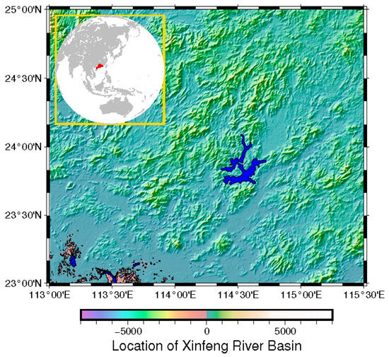
Figure 1.
Location of research area. The blue area at the center of the map denotes the Xinfengjiang Reservoir. The red political area in the inset world map denotes The Guangdong Province, China.
1.2. Two Main Sources of Dongjiang River
1.2.1. Main Tributaries of Upper Dongjiang River—Outer and Inner Rivers
The two source-water systems of the upper reaches of the Dongjiang River meet in downtown Heyuan County and diverge into two tributaries. The one that comes from the Xinfeng River and runs southward is known as the Inner River. It is also the main source of the Wanlv Lake. The other branch that runs northeast into Longchuan is called the Outer River. This divergence also divides Heyuan County into two parts: the Upper and Lower Towns.
1.2.2. Xinfeng River and Wanlv Lake
The Xinfeng River originates from the Yunji Mountain in Xinfeng County, Guangdong Province, and flows through the Xinfeng, Lianping, and Dongyuan counties. Preparation for the construction of the Xinfengjiang Reservoir began in 1953, and the project was completed in 1960. A dam for the reservoir was built at Zhenqian Town in downtown Heyuan, and the Xinfeng River serves as the main source of the Xinfengjiang Reservoir, which is also known as Wanlv Lake.
1.3. Ancient Roads
1.3.1. Guangdong-Jiangxi Ancient Road
The Guangdong–Jiangxi Ancient Road is an ancient passageway connecting Guangdong and Jiangxi Provinces, including land and water routes, developed through both official and non-official efforts. As a significant area where the northeastern part of Guangdong borders Jiangxi, Heyuan becomes a key study area in the research of the Guangdong–Jiangxi Ancient Road for the conservation and revitalization of ancient post roads in Guangdong Province.
The formation of a transportation network between Guangdong and Jiangxi constituted the entity of the Guangdong–Jiangxi Ancient Road, while the people and objects within the network contributed to the humanistic essence of the ancient Road. From the Qin Dynasty, the Guangdong–Jiangxi passageway embodied the extension of a centralized power, reflecting the military and political functions of the ancient passageway. As the Lingnan region became an integral part of the centralized territory of ancient China, a surge in population and the flourishing regional economy led to a heightened frequency in the movement of materials and people. Thus, the Guangdong–Jiangxi Ancient Road emerged as a prominent catalyst for trade and commerce. From the Song Dynasty, the Xinfeng, Longnan, and Dingnan counties in Jiangxi Province developed a preference for sun-dried sea salt. According to a recording about salt administration in the “County Annals of Longchuan” during the Jiaqing reign of Qing Dynasty, “all salt supplies for Longchuan, Heping, Xinfeng, Longnan, Anyuan and Dingnan shall be rationed in Longchuan and transported to each destination from Longchuan”. This was how salt produced in Huizhou was transported northward along the Dongjiang River and then carried to the counties in southern Jiangxi by porters1. It can be seen that, at least before the Qianlong period of the Qing Dynasty, a waterway transportation network, which relied on the Dongjiang River, to connect Guangdong and Jiangxi had already been formed. Daily necessities, such as salt, were already frequently transported through this channel, and the circulation of other commercial goods also grew frequent.
However, although highways already existed in the Republic of China (1912–1949), including the Guangzhou–Shantou Highway passing through Heyuan, transportation in Heyuan was still dominated by water transport and porters because of the scarcity of vehicles. Materials from neighboring areas were transported in large quantities through waterway connections. Local products of Fujian, ceramics and sundry goods from Dabu, cloth and wool from Xingning, and charcoal, bamboo, and wood from Longchuan and Lankou of Liucheng were transported southward through the Dongjiang River. In the north, people relied on the Xinfeng River to transport local products and minerals from Jiangxi, hogs from Xinfeng, the Yangming paper from Heping, smoked garlic from Lianping, and grains and local products from the Xichang, Huilong, Nanhu, and Guling areas southward through the river and to sell them to areas including Huizhou, Dongguan, Guangzhou, and Hong Kong2.
1.3.2. A Transportation Network with Both Land and Water Routes
The main route of the Guangdong–Jiangxi Ancient Road in Heyuan was available for both land and water transportation. Because both the Li and Zhongxin rivers were navigable, water transportation was more advantageous than land transportation in terms of transportation capacity and time efficiency.
According to the “Investigation Report of Guangdong–Jiangxi Ancient Road” compiled by the Guangdong Province Nuclear Industry Geological Bureau’s 292nd Brigade in 2017, the Heyuan section of the Guangdong–Jiangxi Ancient Road mainly covered the territories of Heping, Lianping, and Dongyuan counties. Generally, the main road stretched in a south–north direction, starting from Liyuan in Heping County in the north, passing through Reshui and Qingzhou into Xiuduan in Lianping County, and then through Dahu, Sanjiao, Gaoguan, and Zhongxin before leading to Shuntian, Jiantou, and Shuangjiang in Dongyuan County, finally reaching the Chashan Park in downtown Heyuan. Additionally, this main road was interconnected with water areas.
Clearly, the main route that connected Heyuan with Jiangxi was mainly a land one. The main route in the north ran parallel with the Li River for a long distance. In the south, the main route was closely connected with the Zhongxin River. On reaching Shuntian in Dongyuan, it ran parallel to the Zhongxin River for a short distance before reaching Shuangjiang; it then continued south until it reached downtown Heyuan.
1.4. A Land of Fish and Rice Nurtured by Ancient Waterways
Historically, the Xinfeng River waterway connected the towns of Huilong, Nanhu, Xichang, Shuangjiang, and Banjiang, and it reached as far as Xinfeng County3. In terms of grain production and sales, such as those of rice, Guangdong Province’s rice production in 1937 was 116,997,554 quintals, and the sale was 45,263,112 quintals, with a sales-production ratio of 38.7%, according to the “Survey Report of the Basic industries, Special Industries, and Rural Products in Guangdong Province” compiled in April 1937 by the Guangdong division of the National Economic Construction Movement Committee. In Heyuan County, the rice production was 1,192,950 quintals, constituting 1% of the entire province’s production, and all rice was sold, accounting for 2.6% of Guangdong’s rice sales.
In addition, according to this report, there were 65 factories in Heyuan producing raw materials for brewing rice wine, 165 peanut-oil factories, a well-developed sugar industry, and a well-developed timber industry with an annual output of 1,200,000 cedar trees. In terms of agricultural products, there were hogs, cows, chickens, ducks, and geese; in addition to local supply, hogs were sold to Hong Kong. The data paint a clear picture: during the early years of the Republic of China (1912–1949), agricultural production and trade in the Xinfeng River Basin had already reached a scale that extended its influence to other regions, truly earning its title, “The Land of Fish and Rice around Dongjiang River”.
1.5. A Representative Region of Hakka Sijiaolou Buildings and a Gathering Place of Hakka People
The Hakka originated from the Zhongyuan area of China and experienced five major migrations. During their third migration, at the end of the Southern Song dynasty, many Hakka people from Shibi of Ninghua, Fujian Province, moved to the southeast, enriching the Hakka population in the Xingmei area of eastern Guangdong Province. Later, some Hakka people from the Xingmei area gradually resettled to various locations in Heyuan, including Longchuan, Heping, Yuancheng, Zijin, and Lianping. In the Ming and Qing dynasties, due to the rich produce and convenient water transportation of the upper Dongjiang River and Xinfengjiang River Basin, many commercial hubs were nurtured. Along both sides of the Xinfeng River, typical Hakka commercial towns emerged, including Huilong, Nanhu, Xichang, and Guling [1,2]. Thriving in harmony with their natural surroundings, the ancient Hakka people crafted distinctive residences. These included sijiaolou buildings and enclosed compounds, known for their robust defense capabilities, doubling as central hubs for the gathering and distribution of merchandize [3].
2. Materials and Methods: Survey of Underwater Cultural Relics in Wanlv Lake
In the underwater cultural-heritage survey of the flooded area in Wanlv Lake, we used the EdgeTech4205 side-scan sonar (from Edge Tech Inc. in West Wareham, MA, USA) detection for comprehensive scan, adopted multi-beam fine scan for key areas and those that required clarification, and arranged for diving professionals to confirm the findings and conduct underwater filming. Additionally, drones were used to take aerial photos and videos of the terrain and roads of key areas. Furthermore, we conducted a second check on the remains of ancient docks, post roads, and bridges in the middle Dongjiang River, including Laolong, Tuocheng, Nankou, Yihe, Dengta, Shuntian, Shuangjiang, and other towns.
Overall deployment: Based on the analysis of the above historical information, the investigation lines were arranged from the known to the unknown, and the specific operation was conducted as follows:
- The original Guangdong–Jiangxi Ancient Road continued southwestward from Dengta and Shuangjiang and disappeared in Wanlv Lake in Dou’ao. Therefore, the first investigation line started from where the Dou’ao post road disappeared into the lake and stretched toward the southwest.
- The former Guangdong–Jiangxi highway stretched from the current Xingfeng River fishing pier, turned to the north, and disappeared into Wanlv Lake. Therefore, we arranged an investigation line from the pier to the north.
- The original Xingfeng River was cut off from the dam and continued in the northeast direction; thus, an investigation line was arranged from the dam to the lake area of the Xingfeng River.
- According to an ancient schematic map, the Xingfeng River diverged in the old Huilong Town, with one branch reaching the ancient town of Guling to the west and the other reaching the ancient town of Nanhu to the east and turning northward and then westward to the ancient town of Xichang. Therefore, investigation lines were arranged based on this information.Investigative equipment:Surveys were conducted using the EdgeTech 4205 side-scan sonar (from Edge Tech Inc. in West Wareham, MA, USA).Data-acquisition parameters:Dual-frequency with a width of 200 m.Data-processing flow:
With real-time monitoring of the site investigating graphics, the emergence of underwater artificial remains (farmland, orchards, tea gardens, isolated buildings, villages, and ancient towns composed of groups of ancient buildings) were marked on a regional map in a timely manner with screenshot records. During the detection phase, with reference to the regional map, underwater continuous survey lines, and coherent remains (rivers, paddy fields, and ancient roads), we adjusted the ship’s survey course in a timely manner. In addition, in data processing, we compared the regional map with site records, played back the swept graphics, and put together the distribution maps of the remains in a wider range. For special remains, we displayed vector graphics by selecting the points to obtain detailed data information, including coordinates, depth, widths of the remains, and their estimated heights [4,5].
In this survey, we completed the sonar investigation of more than 70 km2 of water areas. The exact locations of the five ancient towns of Nanhu, Huilong, Xichang, Lixi, and Guling were basically identified. In addition, the distributions of the specific river network of the upper reaches of the former Xinfeng River, Guangdong–Jiangxi Ancient Post Road in the inundated area, and trading route within the area were also basically confirmed (Figure 2). Location of each archaeological object is denoted on the map using the GPS coordinates (Figure 3).
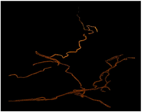
Figure 2.
A map of areas covered by sonar detection lines.
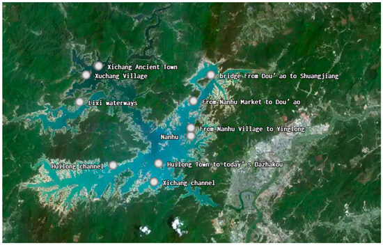
Figure 3.
The location of each archaeological object following the GPS coordinates.
2.1. Survey of the Remains of Linear Ancient Post Roads
After the water level of the Xinfeng River Reservoir dropped, more land was exposed where the edge of the reservoir and the waterways of the lake island met, and large areas of river beds of the upstream Xinfeng and Zhongxin rivers were also exposed. All of the newly discovered remains of linear ancient roads from this survey are mostly located in these areas (Figure 4).

Figure 4.
The Dou’ao ancient road.
2.1.1. Onshore Survey
In 2017, the Guangdong Nuclear Industry Geology Bureau conducted a comprehensive survey of the Heyuan section of the Guangdong-Jiangxi Ancient Road, covering a total distance of 264 km. The findings revealed that 20.6 km were remarkably well-preserved, 12.5 km showed general preservation, 54.6 km were relatively poorly preserved, and the remaining 176.3 km were in a state of poor preservation.
2.1.2. Underwater Survey
This underwater investigation of Wanlv Lake confirmed the description of the waterway post routes in the county records to some extent, and some new insights were obtained. The Shuangjiang–Dou’ao segment of the main land route of the ancient road between Shuangjiang and downtown Heyuan can be connected to the Nanhu waterway in the southwest. The Nanhu waterway ran from the northeast into the Xinfeng River and finally fed into the Dongjiang River to arrive in downtown Heyuan. Along the Nanhu waterway, many branches of the ancient road linked the surrounding villages and towns. At least in the upper reaches of the Nanhu waterway, parallel ancient roads and river channels remain. From Shuangjiang to downtown Heyuan, both water (the Nanhu waterway) and land (Guangdong–Jiangxi Highway) routes were available. The Xinfeng River, another major branch of the Dongjiang, was mainly connected by waterways, as no major ancient roads were distributed on the river’s two sides. There are three specific routes:
- running westward from Huilong to Guxu and Xichang;
- running northward from Huilong, with a branch running westward to Lixi;
- then running northward to Lianping and turning back to a land route.
In addition, surveys of bridges around Nanhu’s waterways also help to deepen the understanding of how land and water transportation in this area worked in parallel.
This survey has learned about the ancient roads outside the main route of the Guangdong–Jiangxi Ancient Road, which are mainly located under the Wanlv Lake and in the basins of the Xinfeng and Zhongxin rivers, with the following four specific discoveries.
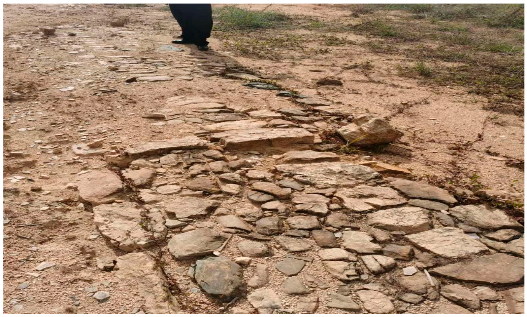
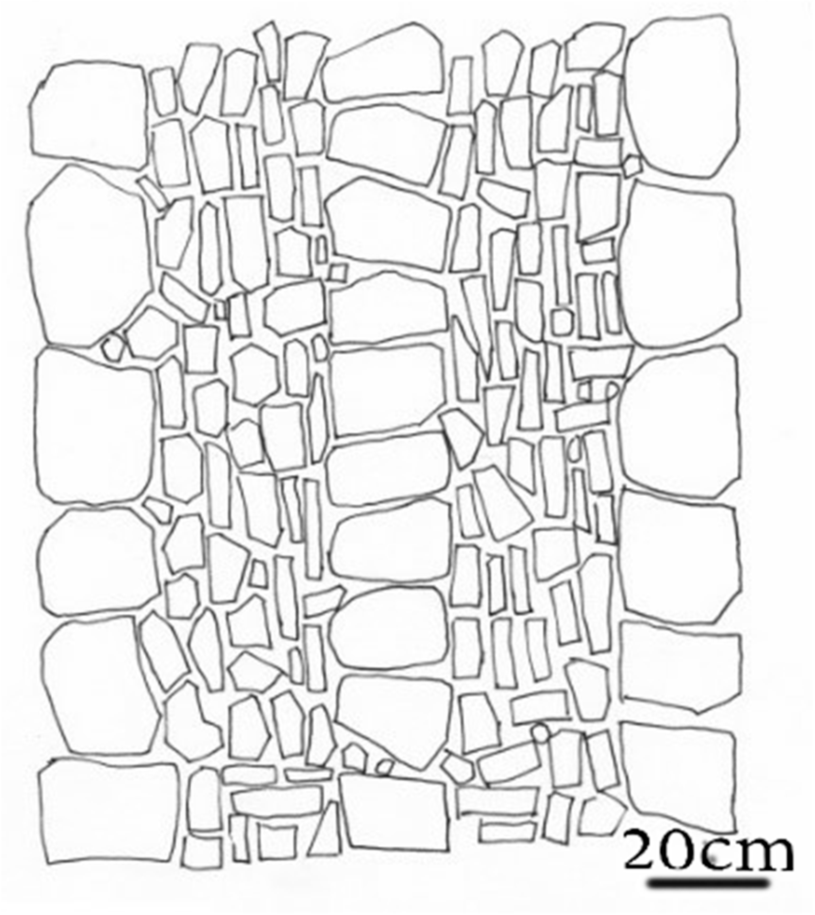
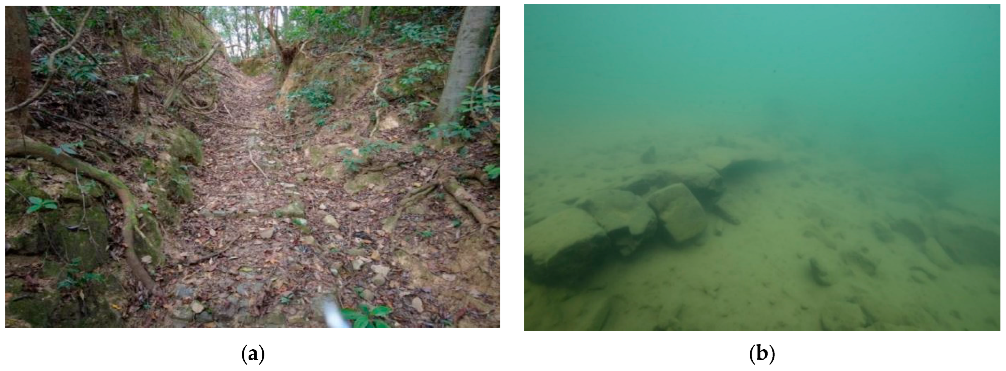
The Dou’ao Ancient Road4 is located in Doubei Village of Xingang Town. It is approximately 0.57 km long and 1.8 m wide, paved with rubble, and it features steep slopes in a stepped pattern and an overall north–south direction. In 2018, it was restored as a key construction section of the ancient post roads in Guangdong. Following the Dou’ao ancient road and navigating the mountains from north to south, one will reach the edge of Wanlv Lake. In the once-submerged area, the underwater part of the Dou’ao Ancient Road was found to be connected to the southern end of the ancient road, with remnants of the linear ancient road extending all the way into the lake. The road-surface condition was poorly preserved, with many tilted pavements and crippled road surfaces. A complete ground surface appears where the ancient road enters the water and continues into the lake (Figure 5).
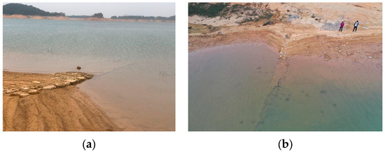
Figure 5.
Lakeside (a) and aerial (b) photos of where the Dou’ao Ancient Road disappeared in water.
The pavement at the water-entry point is relatively intact, measured at approximately 1.2 m wide (Figure 6). It is constructed of rocks with regular pavement. Large stones were paved at both ends and in the middle of the roadway, with smaller stone filling the gaps between the large stones5. According to the underwater diving survey, the ancient road extended toward the center of the lake after it went into the water. The preservation condition is poor, as the underwater road surface was wrecked without a visible, complete road section. The remnants of the road surface are broken while extending southwest into the bottom of the lake and are gradually being covered by silt. The specific length is unknown (Figure 7).

Figure 6.
The stone-path structure of the Dou’ao Ancient Road.

Figure 7.
Comparison of uninundated and submerged parts of Dou’ao Ancient Road. (a) The well-preserved Dou’ao Ancient Road, and (b) the remaining underwater Dou’ao Ancient Road.
Xiaodong Ancient Road
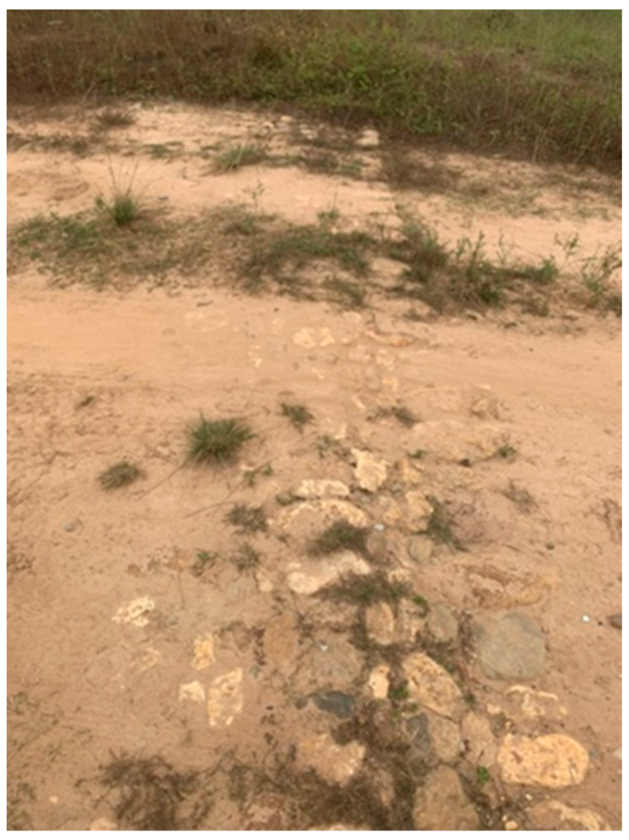
In the northwest of Xiaodong Village in Xingang Town, the valley that was originally flooded has now been completely exposed after the water level dropped. Traveling northwest from Xiaodong Village for approximately 2.5 km and then turning to the east and navigating to the innermost end, one will find the remains of an ancient linear road running southwest–northeast in between the valleys from Yingpan to Kuzhukeng. This road is known as the Xiaodong Ancient Road.
The ancient road In Xiaodong Village Is 1 m to 1.2 m wide, with a residual length of approximately 80 m, and the road surface is paved by smaller stones in a certain stepped shape. The road surface is poorly preserved, with varying degrees of tilting, missing, and burying (Figure 8).

Figure 8.
Dongping Ancient Road.
Dongping Ancient Road
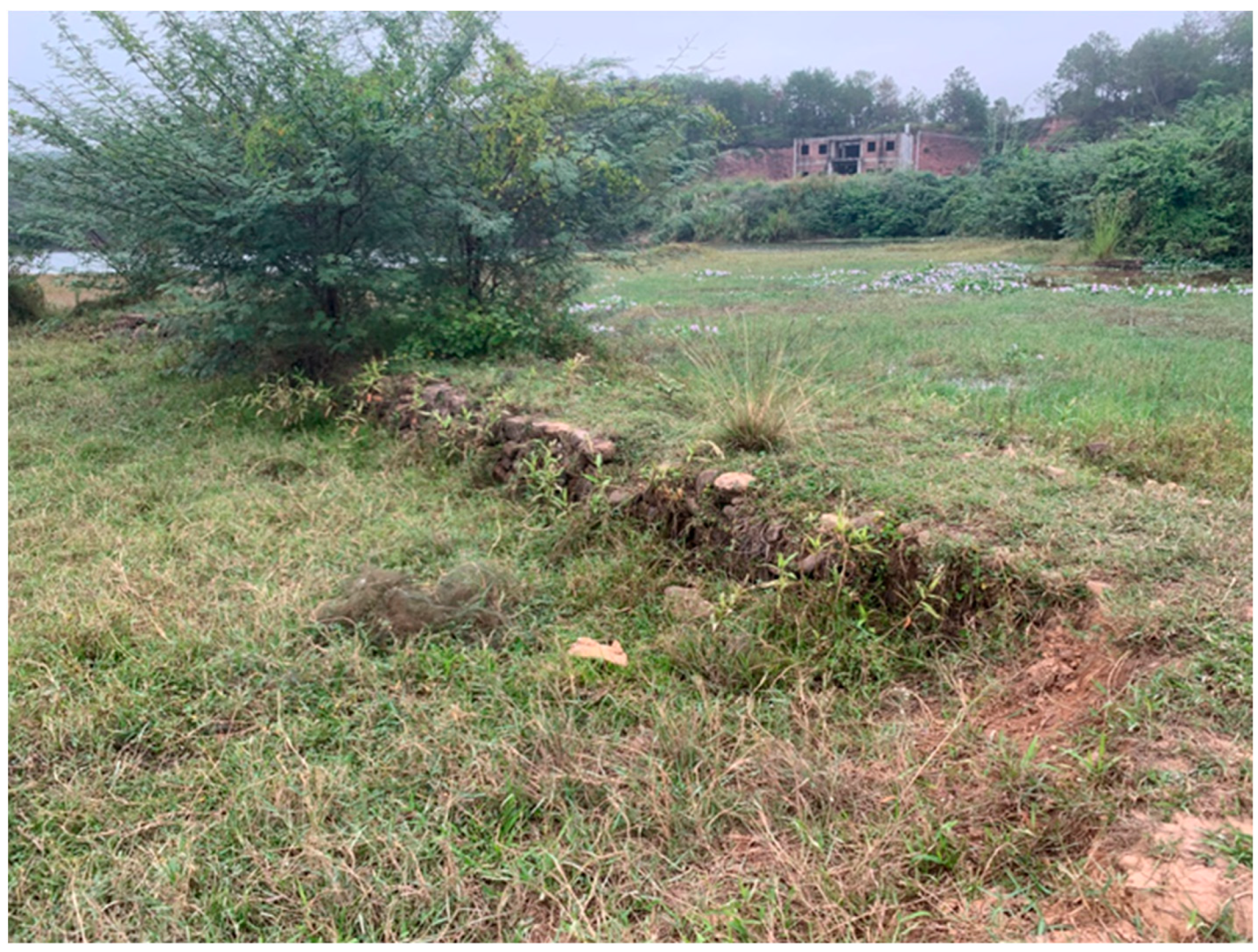
Located to the east of Yuandaodong, a naturally formed village in Ca’e Village of Jiantou Town, the Dongping Ancient Road, inundated after the reservoir was constructed in 1959, was exposed after the water level dropped. The ancient road runs roughly east–west, extending from the river to the mountains, and is currently located in a dry reservoir bed. The remnant road, paved in cobbles, is 1 m to 1.5 m wide and 40 m long. Two miles south of the remains of the Dongping Ancient Road, there is a ferry site, where the top of a stele was found with “Yuantan Ferry Stele Inscription”6.
Xialin Ancient Road
In Xialin Village of Shuangjiang Town7, the remains of a linear ancient road was found in front of the Huang Family’s Ancestral Hall, which was flooded during the period of abundant water. It extends from the front of the Huang Family’s Ancestral Hall to the river, lying 30 cm to 50 cm high above the current road surface and with a width of 1 m to 1.2 m and a residual length of approximately 50 m. The road features an elevated roadbed with a pavement of cladding stones. Although its preservation is acceptable, there are noticeable gaps in the paving stones, while the cladding stones on both sides remain relatively well preserved (Figure 9).
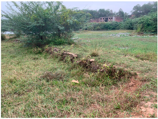
Figure 9.
Xialin Ancient Road.
The tracking of the water-entry and submerged parts of the Dou’ao Ancient Road and establishment of a standardized graphic for examining the ancient road based on sonar imagery revealed that, along the main channel of the Xinfeng River and banks of the waterways in Nanhu, Guling, and Lixi at the confluences, the villages and towns were well connected by a network of roads, and bridges were erected in the case of streams. Unfortunately, the ferry crossing the waters of Nanhu could not be found or identified.
2.2. Survey on Underwater Linear Ancient River Courses
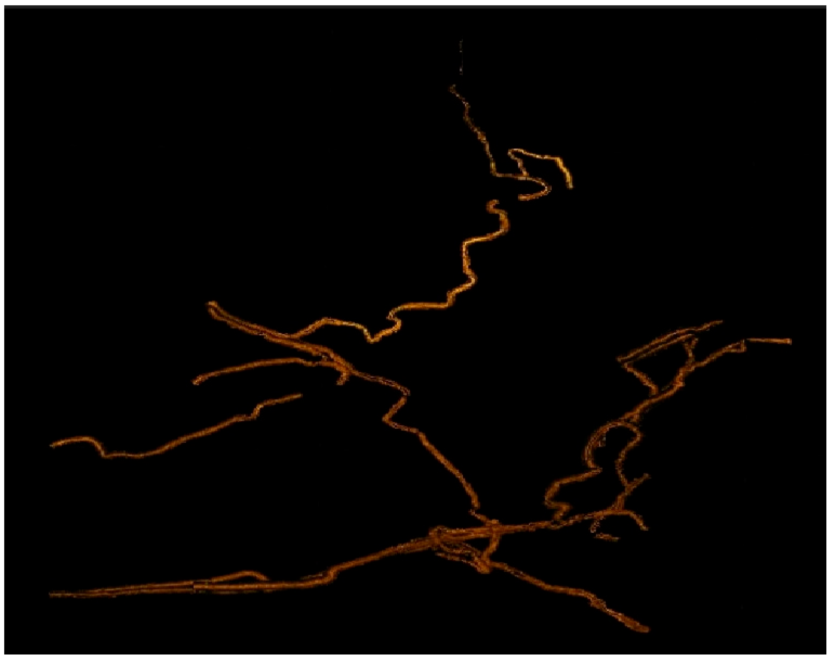
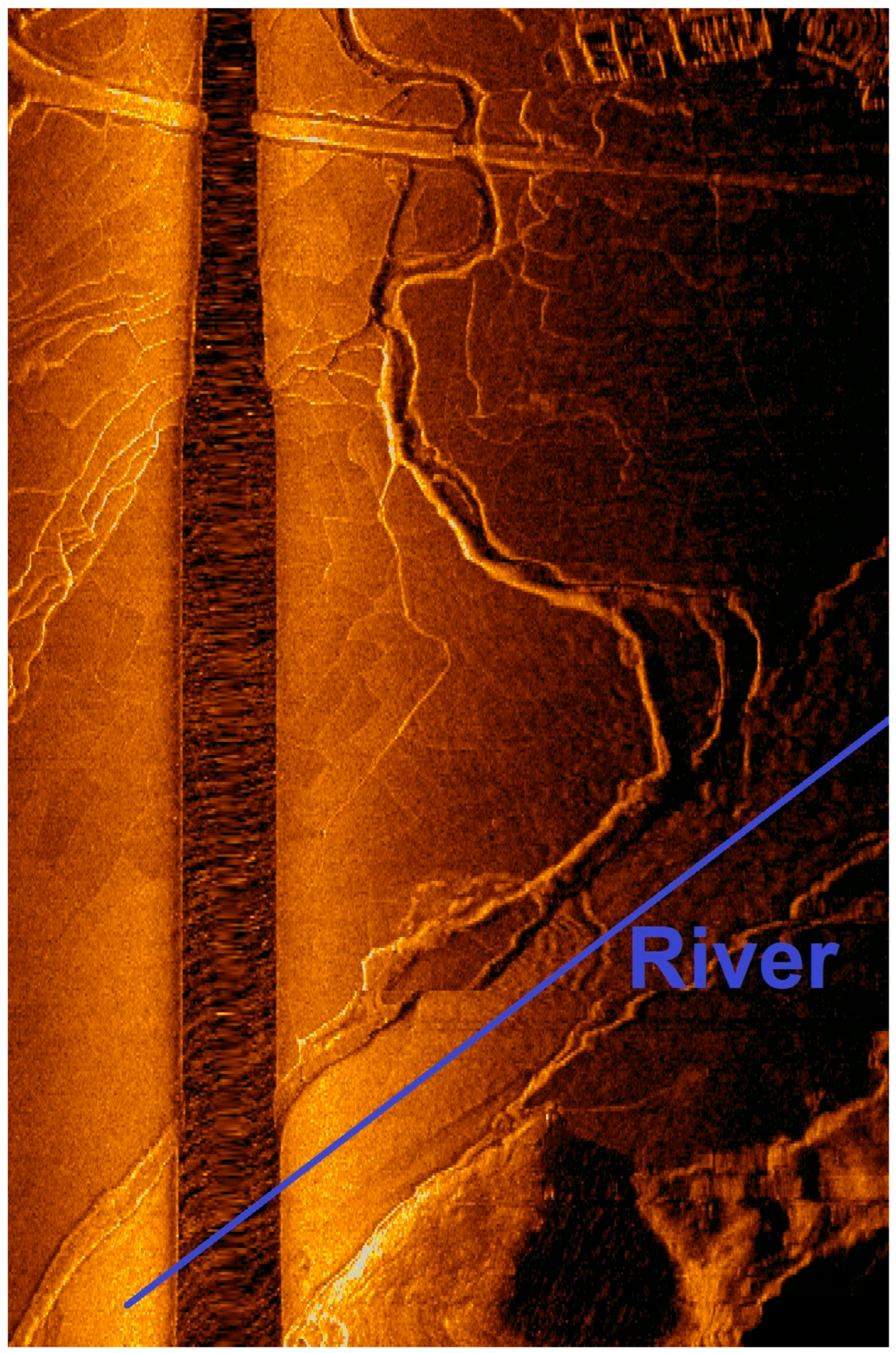
The underwater remains were swept by shipboard sonar equipment. Sonar scanning was categorized into two main techniques: linear-tracking and wide-ranging, region-focused investigating. Initially, the approach involved tracing ancient rivers, highways, and township roads based on historical maps and other relevant clues. Subsequently, the process shifted to linear-tracking scanning. Gradually, we discovered the flow and connections of ancient waterways in the towns of Nanhu, Guling, Lixi, and Huilong.
The lower stretches of the Xinfeng River converged with waterways in Lixi, Guling, and Nanhu. Following the dam construction, the area transformed into the Xinfeng River Reservoir. Submerged beneath its waters are not only the downstream sections of the original Xinfeng River, but also the river courses of Lixi, Guling, and Nanhu waterways. In this survey, the sonar detection tracked the main channel of the Xinfeng River and river courses of the Lixi, Guling, and Nanhu waterways (Figure 10).

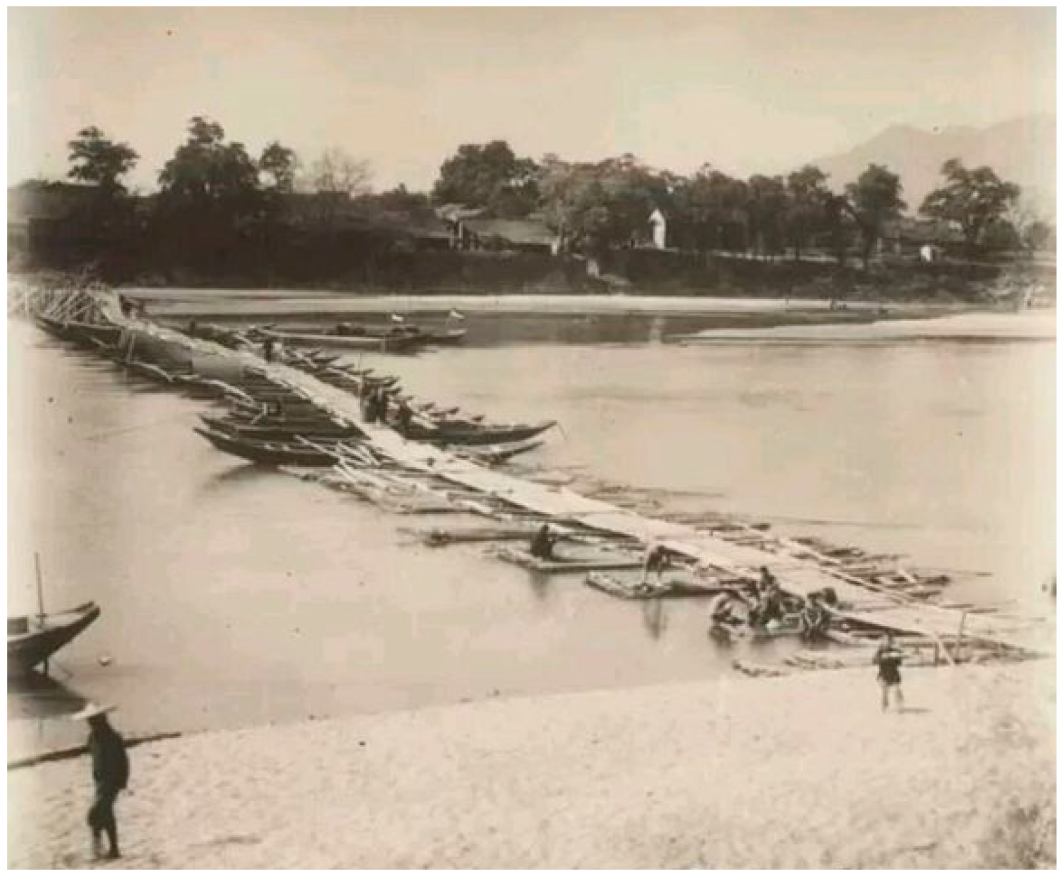
Figure 10.
Dongjiang River before the construction of the reservoir.
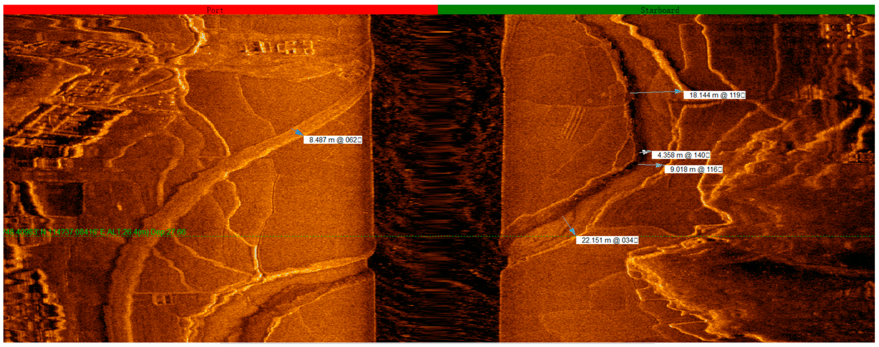
From the sonar map, the water network within the inundation zone of the Xinfengjiang Reservoir appears intricate, with numerous small tributaries running down from the mountains in the river-valley region. These tributaries merge into the Nanhu, Guling, and Lixi waterways before eventually converging back into the Xinfeng River. Near the point where the Nanhu waterways merge with the Xinfeng River’s main channel, the Nanhu waterways reach a maximum width of more than 181 m, as indicated by the sonar-map measurements (Figure 11, Figure 12, Figure 13, Figure 14, Figure 15, Figure 16, Figure 17, Figure 18, Figure 19, Figure 20, Figure 21, Figure 22 and Figure 23).
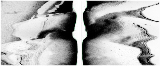
Figure 11.
Sonar map of the Xinfeng River.

Figure 12.
Sonar map of the Nanhu waterways.

Figure 13.
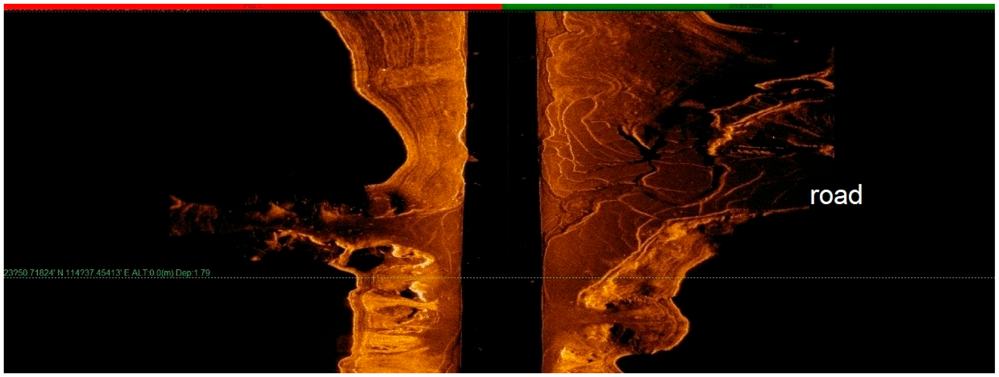
The highway near the Nanhu waterways spanned a width of 8.5 m. The waterways varied in width, ranging from 9.0 m to 22.151 m, with a depth of 4.3 m. GPS coordinates: 23°48.33232′ N, 114°37.11502′ E.
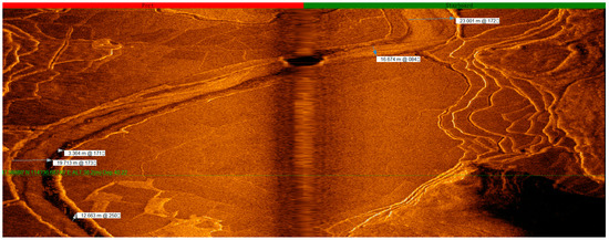
Figure 14.
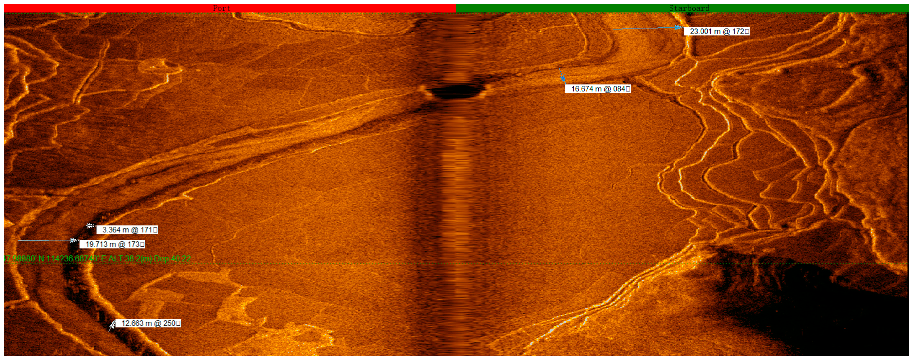
Tributaries of Nanhu waterways, with varying widths of 16.674 m to 23 m and original depths of 3.3 m to 12 m. GPS coordinates: 23°47.99988′ N, 114°36.65348′ E.
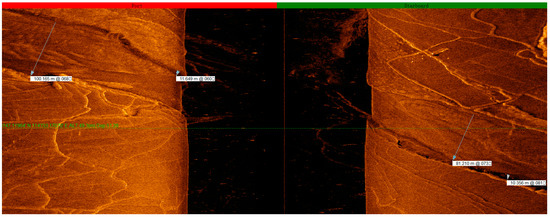
Figure 15.
The Nanhu main channel with widths varying from 100 m to 81 m and original depths fluctuating from 10 m to 11 m. GPS coordinates: 23°47.05621′ N, 114°33.26731′ E, with a current depth of 48 m.
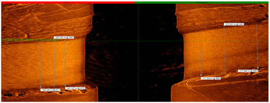
Figure 16.
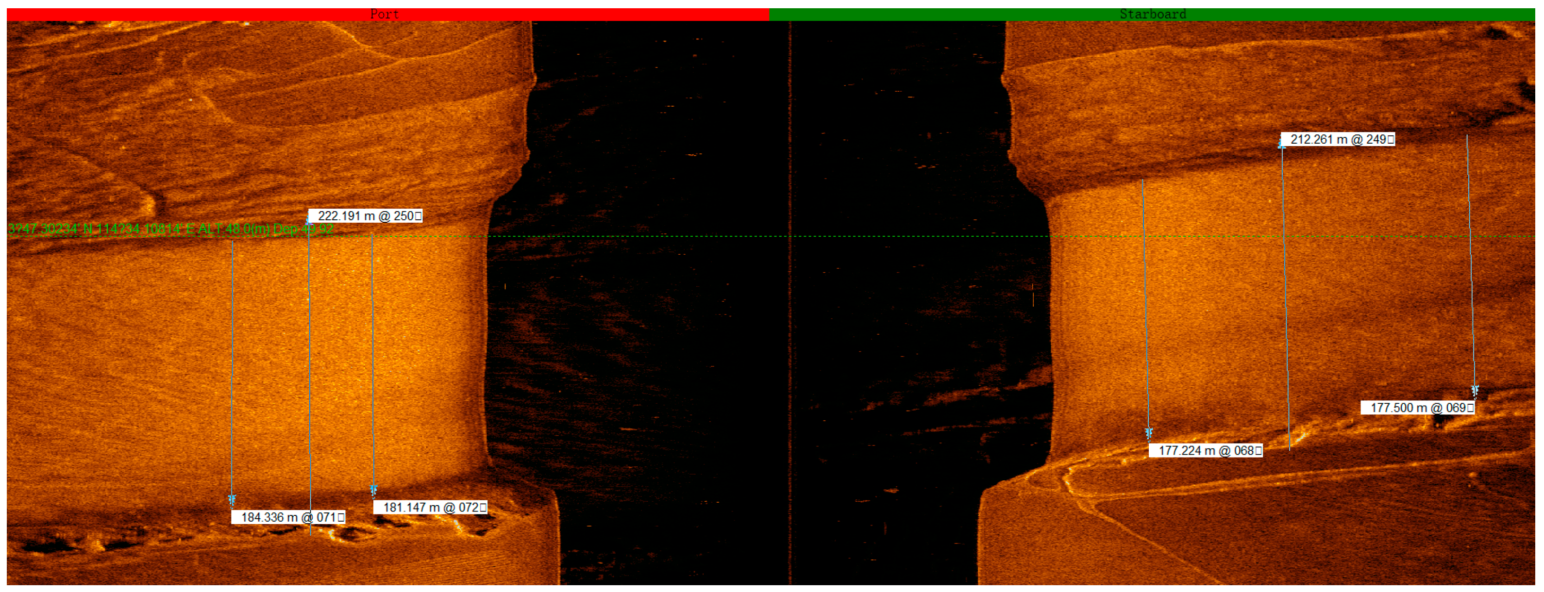
The Nanhu Channel 2: 177 m to 154 m; GPS coordinates: 23°47.28242′ N, 114°34.15326′ E, with a depth of 54.9 m.
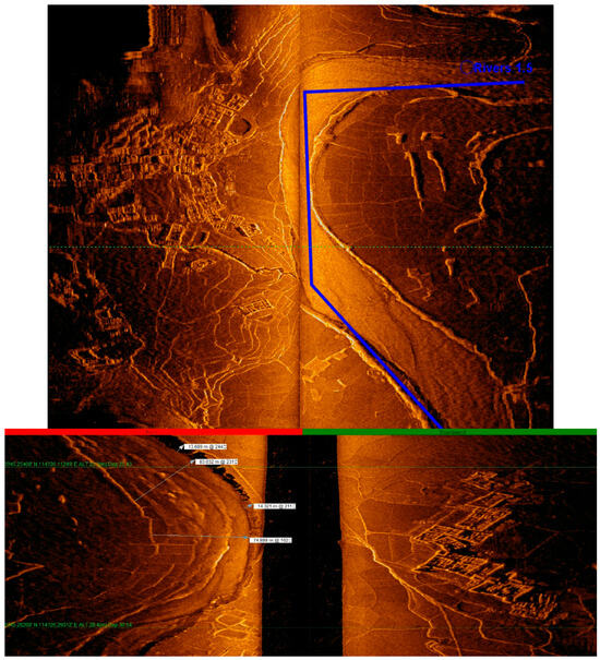
Figure 17.
The Guling waterways.
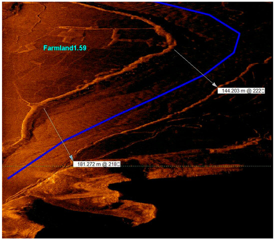
Figure 18.
The width of the channel at the confluence point where the Nanhu waterways merged into the Xinfeng River.

Figure 19.
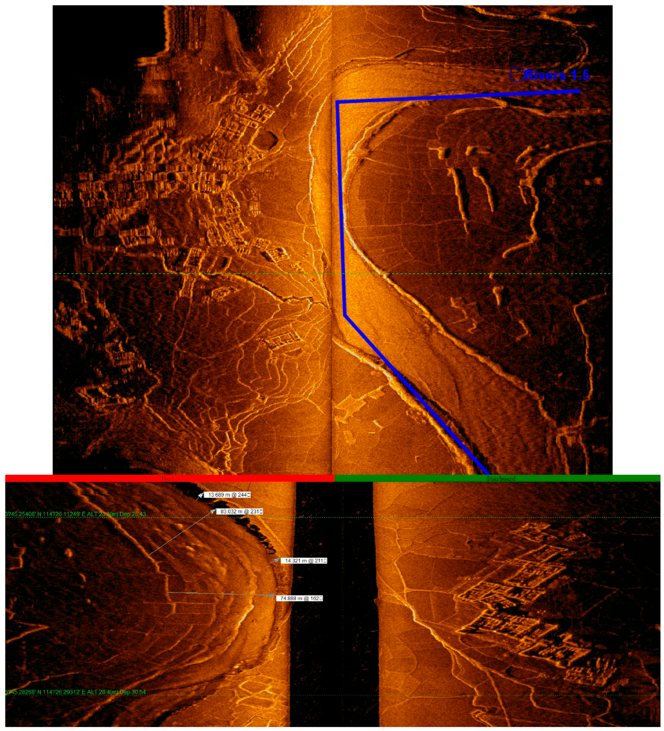
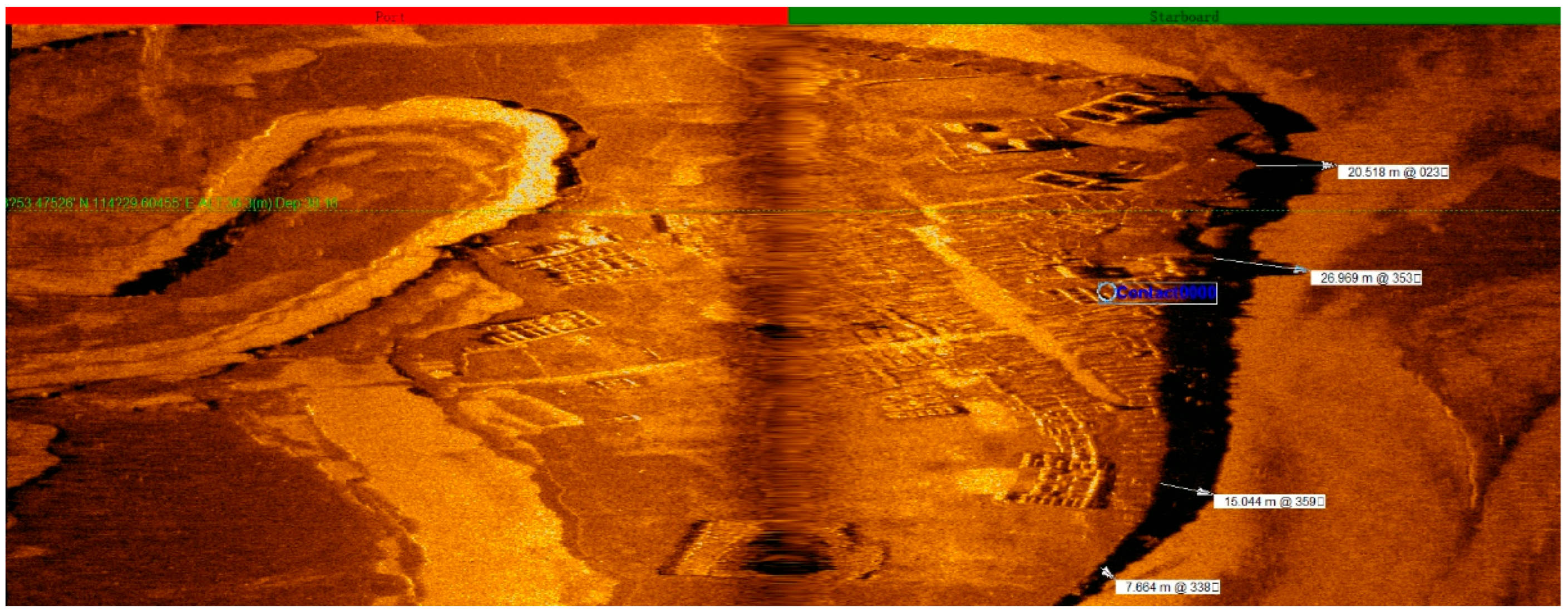
A U-shaped waterway near Xichang Ancient Town. GPS coordinates: 23°53.59708′ N, 114°29.48571′ E, with a depth of 35.9 m.
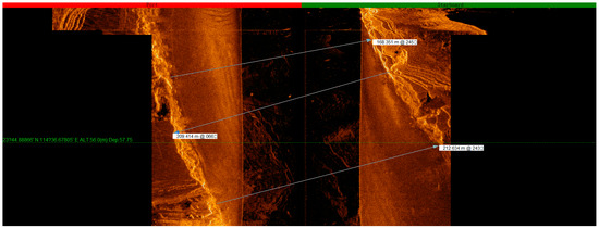
Figure 20.
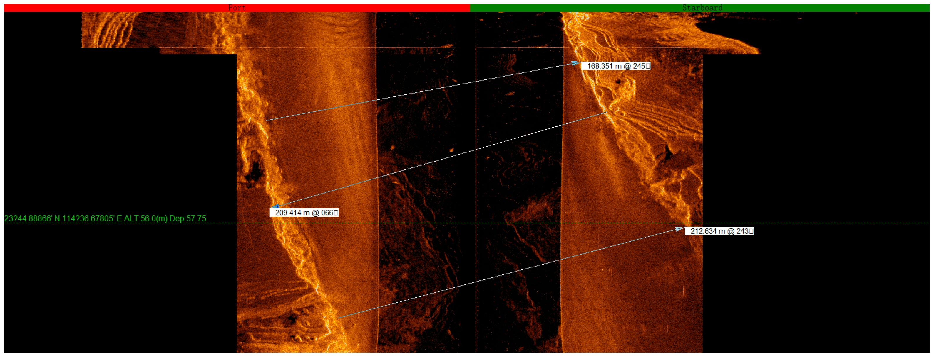
The widest section of the old Xichang channel is 212 m wide. GPS coordinates: 23°44.84515′ N, 114°36.74296′ E, with a current depth of 54.1 m.
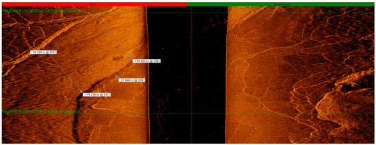
Figure 21.
The old Huilong channel is 179 m wide, with its original depths varying between 18 m and 21 m. GPS coordinates: 23°46.09602′ N, 114°30.70368′ E, with a current depth of 41.7 m.

Figure 22.
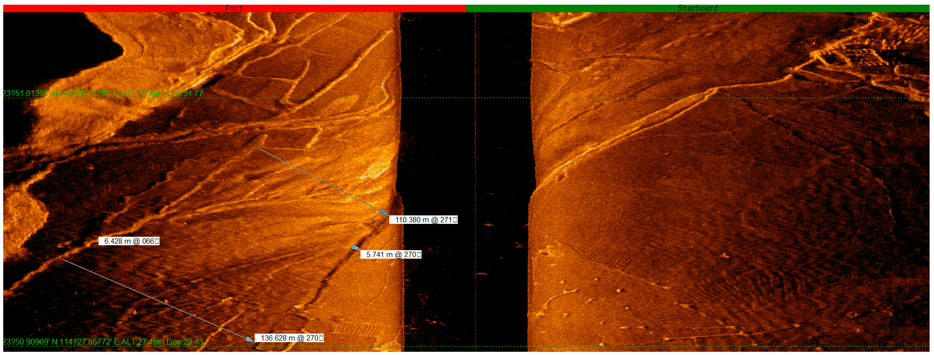
The widest section of the Lixi waterways varies between 110 m and 136 m wide, with their original depths fluctuating from 5 m to 6 m. GPS coordinates: 23°50.89608′ N, 114°27.93038′ E, with a current depth of 27.5 m.
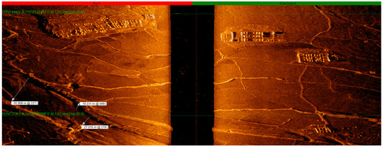
Figure 23.
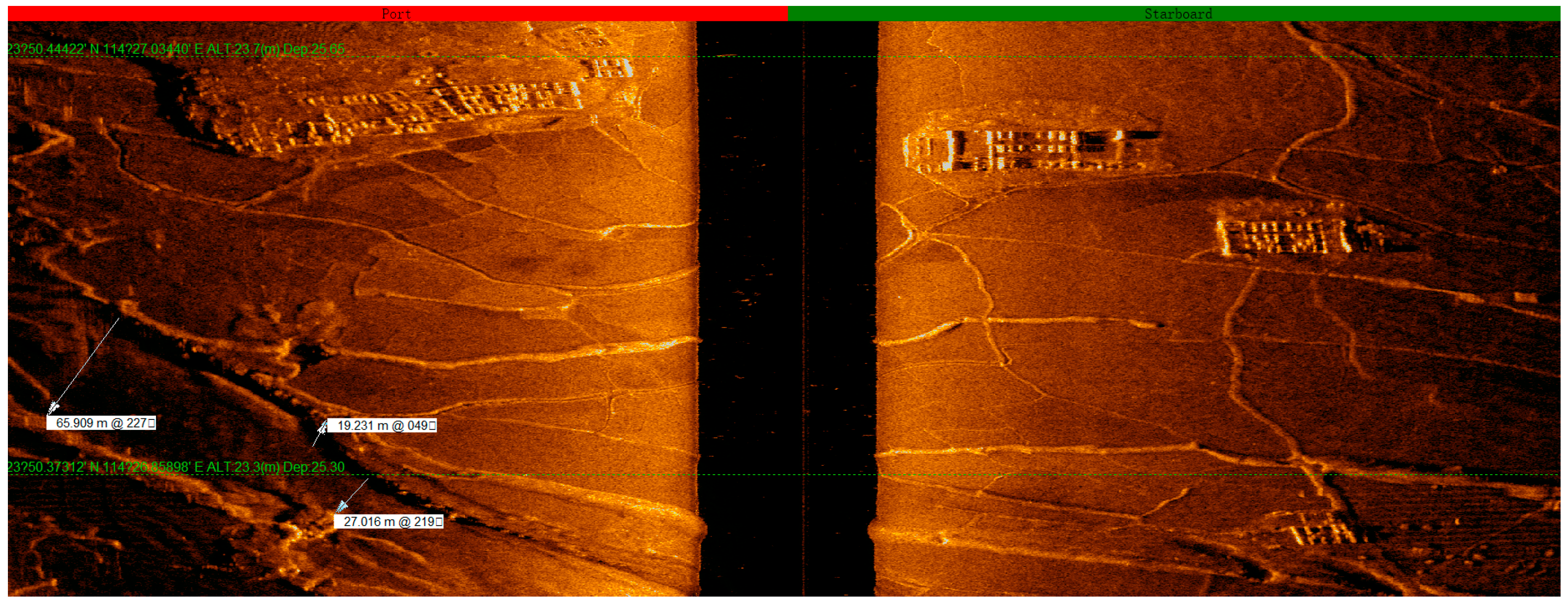
The narrowest section of the Lixi waterways ranges from 27 m to 65 m in width, with a depth of 19 m. GPS coordinates: 23°50.31488′ N, 114°26.91404′ E, with a current depth of 23.1 m.
The old Xichang channel has a width of approximately 120 m, with its original channel depths varying from 7 m to 26 m.
While tracing the Nanhu waterways, we uncovered the Guangdong–Jiangxi Highway constructed between 1912 and 1949. The highway’s path roughly aligns with the course of the Nanhu waterways and runs toward the river valley. At times, it closely parallels the Nanhu water channels, and at other times, it veers away. In the cases of small tributaries merging into the Nanhu waterways (Figure 24), wooden bridges were erected for passage (Figure 25).
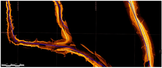
Figure 24.
The location where the Xinfeng River waterway in the old Huilong Town, a Xichang waterway, and a Nanhu waterway merged and took a turn.

Figure 25.
Ancient roads and highways.
As a main part of the Guangdong–Jiangxi passages, the Li and Xinfeng rivers, two significant tributaries of the Dongjiang River, both have their own waterway narrative,8 a melodic account of the boat routes. These narratives specifically document the culture, landscapes, as well as the shoals and rapids along the courses, reflecting the frequency of use and importance of water transportation in Heyuan.
The waterway system formed by the Dongjiang, Li, and Xinfeng rivers served as a main waterway in Heyuan. It joined the north–south main route of the Guangdong–Jiangxi Ancient Road to constitute the basic structure of the Heyuan segment of the Ancient Road, characterized by a blend of land and water transportation.
The underwater investigation of the Xinfengjiang Reservoir has enriched the knowledge of the specific forms of the branch lines, township roads, and land and water transportation of the Dongyuan County segment of the Guangdong–Jiangxi Ancient Road. It has verified the locations and general directions of the Nanhu, Guling, and Lixi waterways at the lower reaches of the Xinfeng River. The area within the original Xinfeng River Basin, submerged beneath the Xinfengjiang Reservoir, has a dense water network. The valley area has many small tributaries running down from the mountains and, respectively, merging with the Nanhu, Guling, and Lixi waterways, before ultimately returning to the Xinfeng River. However, there was a lack of spacious land passages within the area. Through sonar-map calculations, we found that the widest part of the Nanhu waterways was approximately 181 m wide, while the original main channel of the Xinfeng River spanned a width ranging from 80 m to 120 m. Additionally, both the Guling and Lixi water channels measure approximately 80 m in width. These data demonstrate the advanced state of water transportation in the Xinfeng River Basin in that period and provide evidence that land transportation in the region was relatively underdeveloped (Figure 26).

Figure 26.
Country lanes spread across the fields.
2.3. Historical Sites of Docks and Ferries
This survey also investigated and reviewed several docks and ferries along the Dongjiang River. We tracked from downtown Heyuan, along the Dongjiang River, all the way upstream until Laolong in Longchuan, and we examined several docks and ferries, including the historical sites of Longjin Evening and Guyun ferries, Yihe Dock, Yijiang Ancient Temple Dock in Sujiawei, and Lankou, Liucheng, Tuocheng South Gate, and Longchuan Laolong ferries. Although most of these docks and ferries served boats crossing the Dongjiang River, and only the Yijiang Ancient Temple Dock in Sujiawei was used for long-distance non-local vessels, they provide valid evidence for the existence of a major water route along the Dongjiang, Li, and Xinfeng rivers. These historical sites include sites where remains and relics are recognizable, as well as several sites that have been altered or buried where remains are no longer recognizable (Figure 27, Figure 28, Figure 29, Figure 30, Figure 31, Figure 32, Figure 33, Figure 34, Figure 35 and Figure 36).
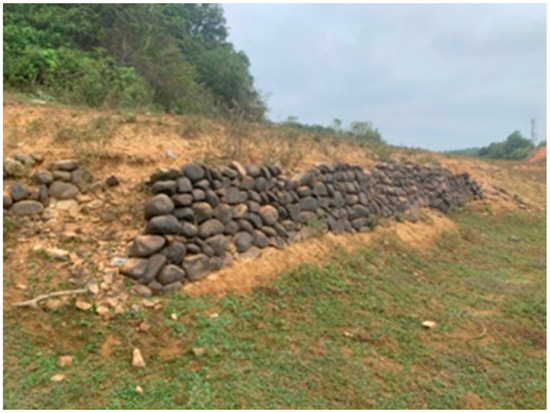
Figure 27.
The historical site of Juxi Bridge Dock9.
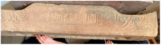
Figure 28.
Historical site of the “Yuantan Ferry Stele Inscription”.
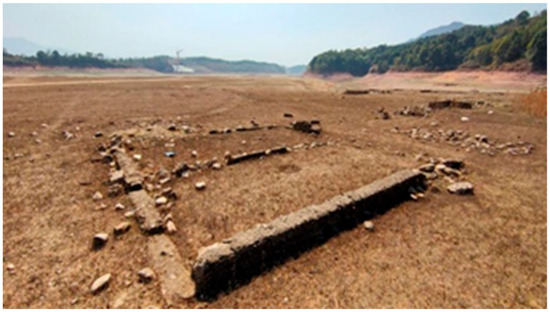
Figure 29.
The historical site of the Longjin Ancient Ferry10.
Figure 30.
The historical site of the Guyun Ferry11.
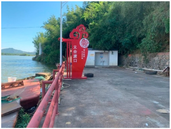
Figure 31.
The historical site of the Yihe Ferry.
Figure 32.
The Yijiang Ancient Temple Dock at Sujiawei.
Figure 33.
The historical site of the Lankou Ferry.
Figure 34.
The historical site of the Liucheng Ferry12.

Figure 35.
The historical site of the Tuocheng South Gate Ferry.
Figure 36.
The historical site of the Longchuan Laolong Dock.
In the area submerged beneath the reservoir, almost in every ancient town, there were roads that connected with the ancient rivers, as well as historical sites similar to docks, as indicated by the sonar maps.
2.4. Ancient Bridges
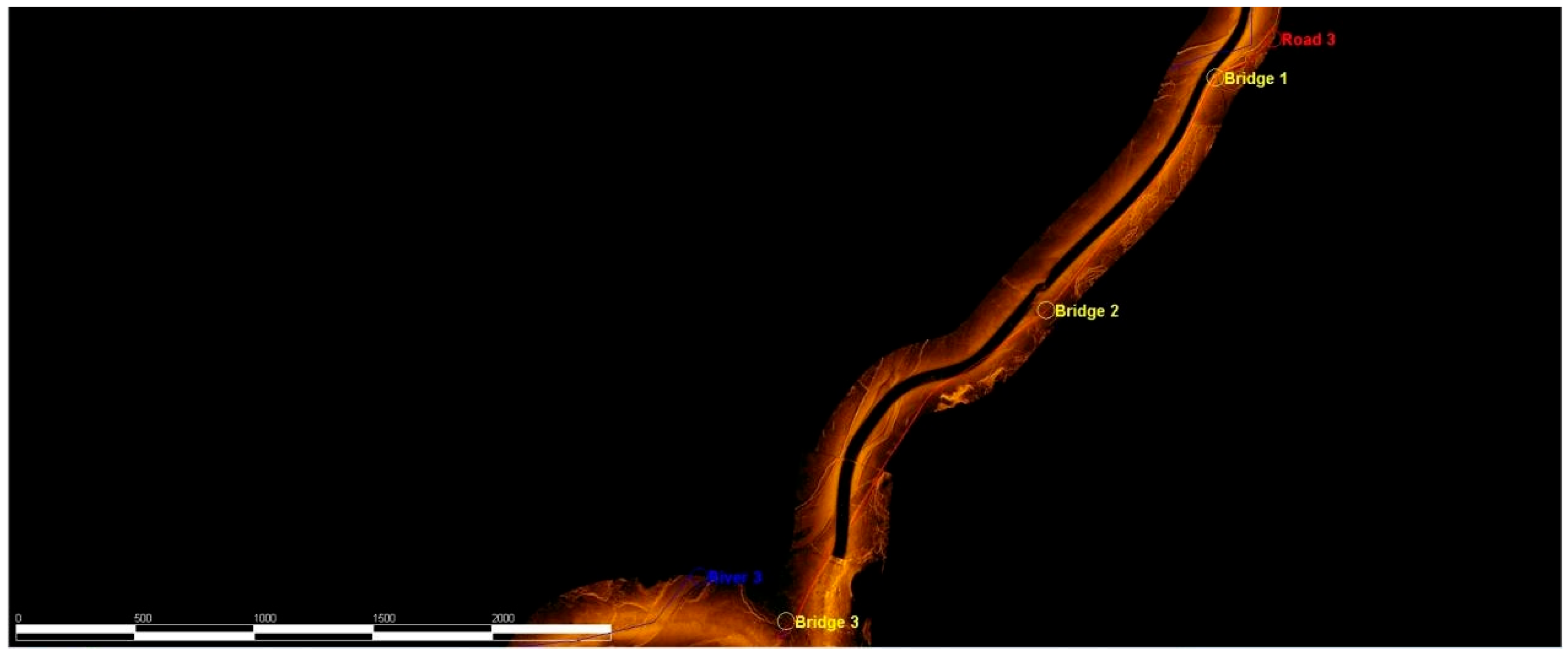
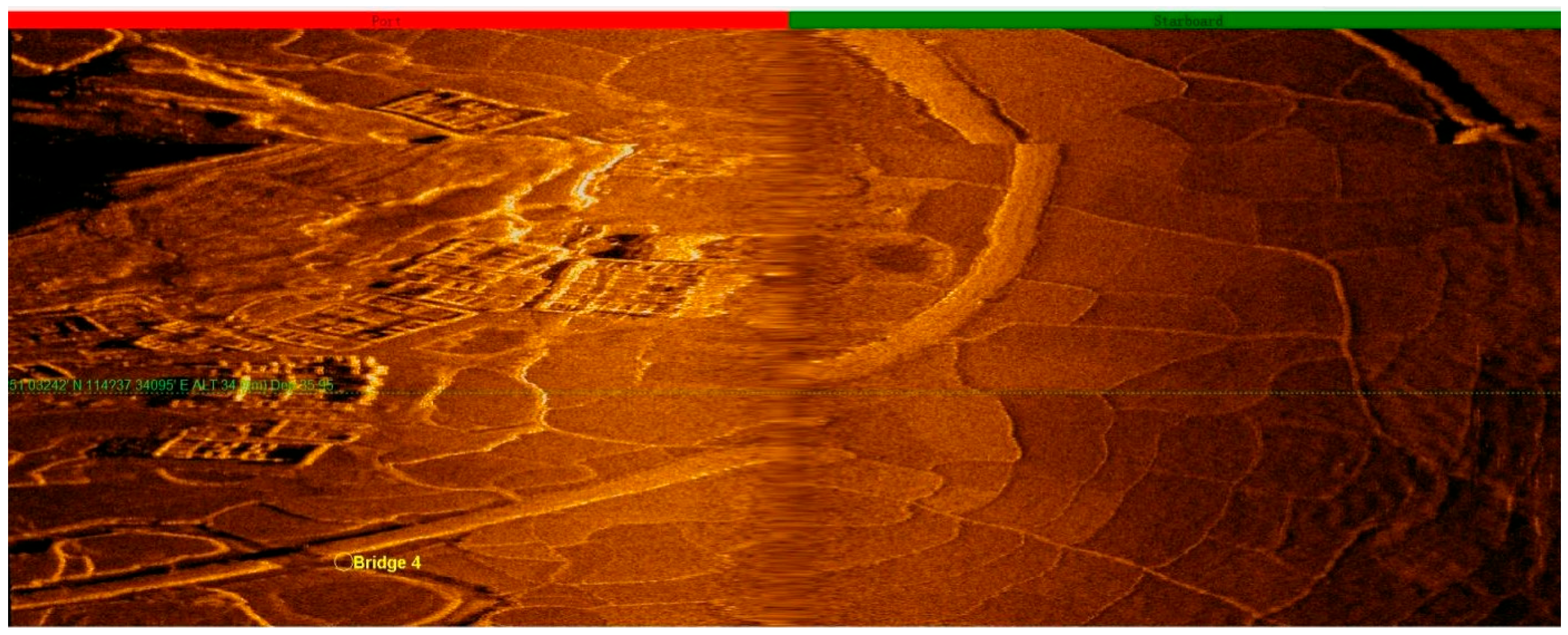
This survey identified 12 submerged bridges. They were scattered above the former Nanhu and Guling waterways and waterways in Huilong Town near the former Xinfeng River Basin, and one of them was a wooden bridge. In addition, four bridges exposed above the water were re-examined. Table 1 shows the GPS coordinates of the bridges from Dou’ao to Shuangjiang (Table 1, Figure 37).

Table 1.
GPS coordinates of the bridges from Dou’ao to Shuangjiang.

Figure 37.
Locations of some of the bridges.
Nanhu Underwater Ancient Wooden Bridge
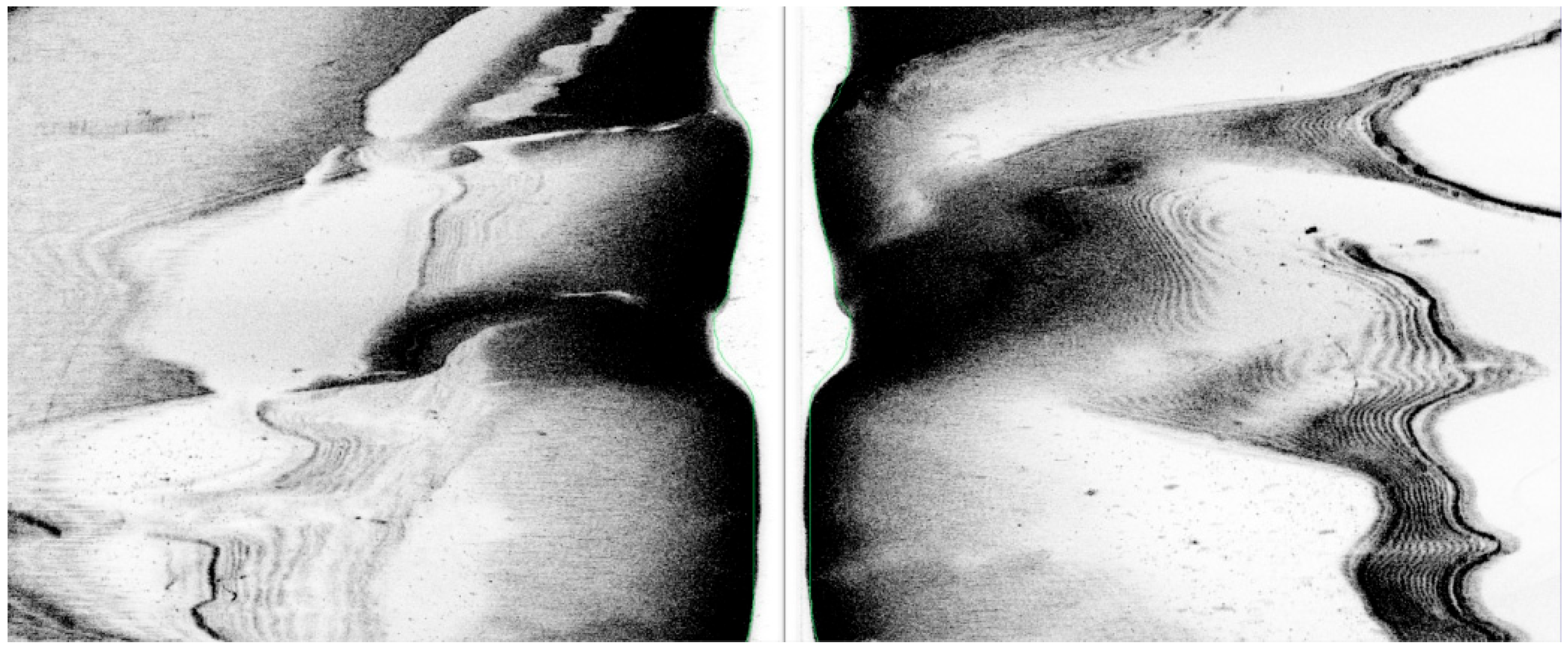
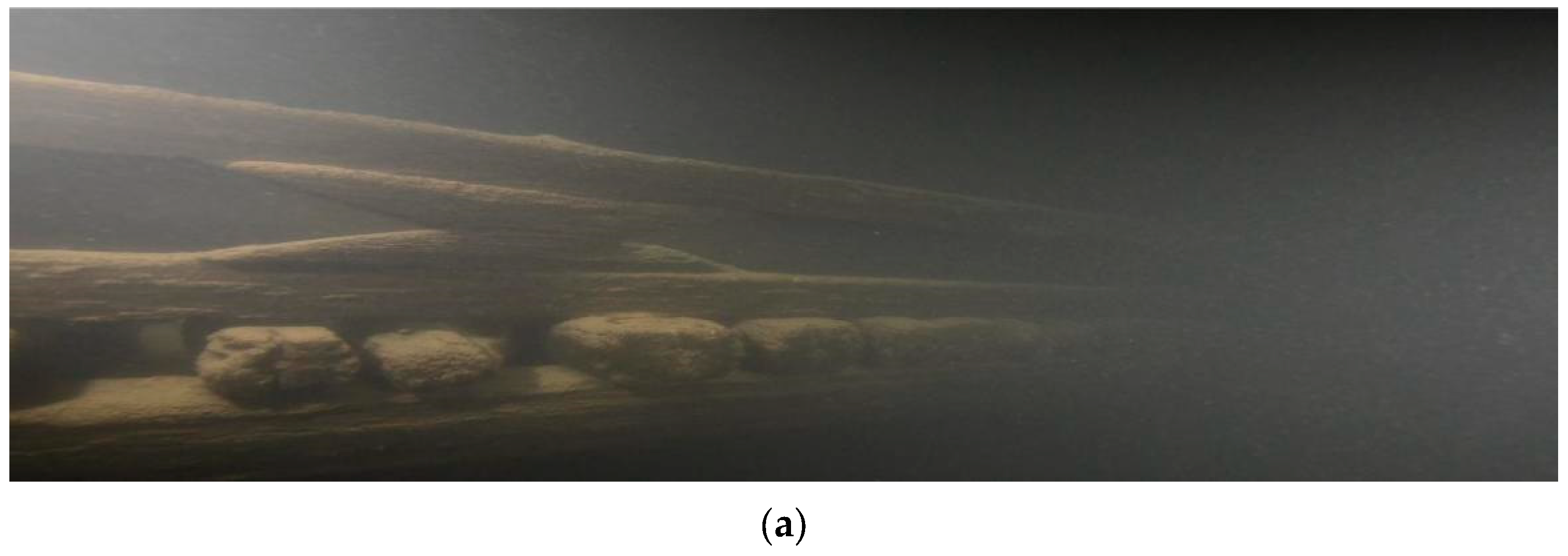
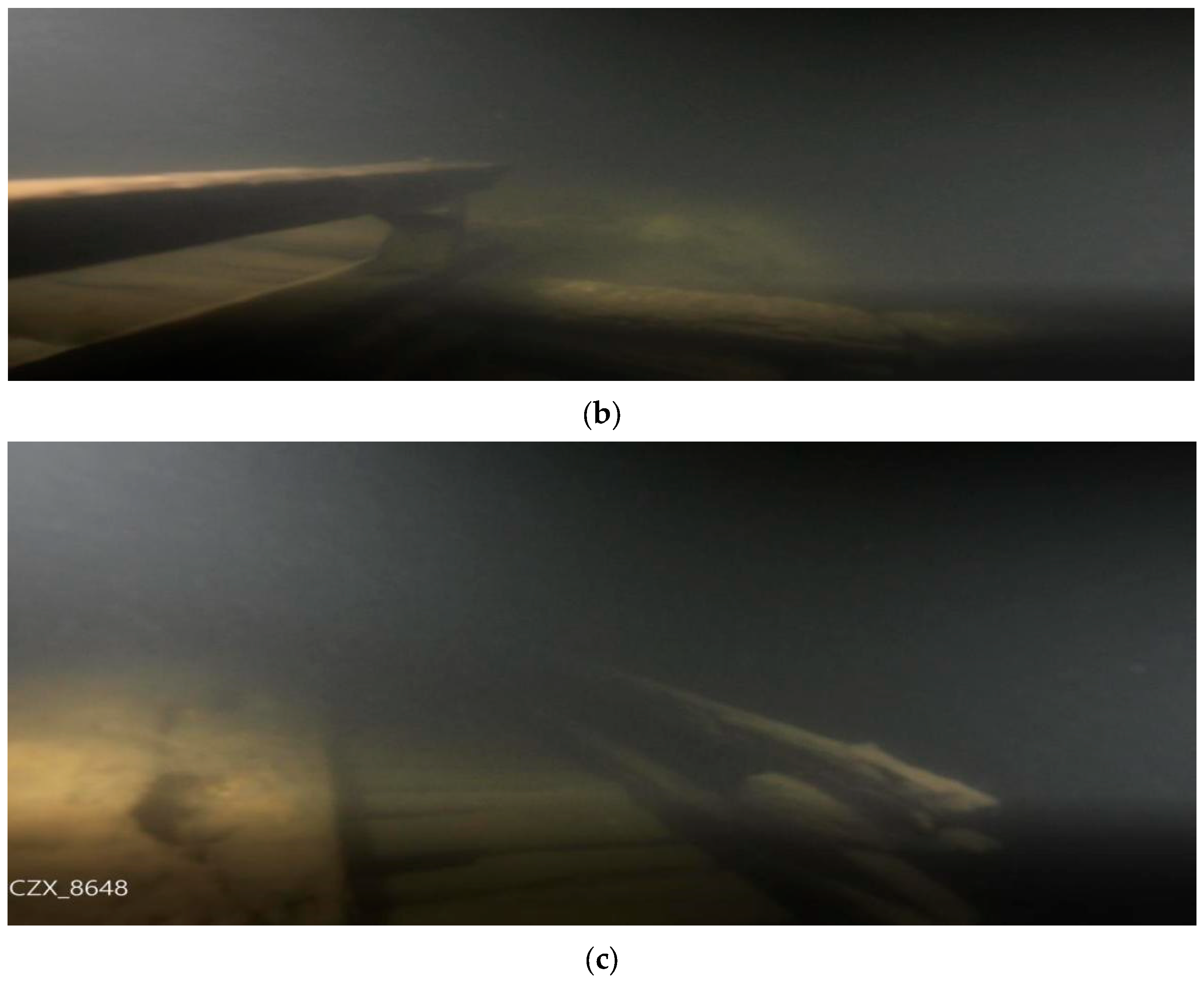
A wooden bridge was found in the flooded area beneath Wanlv Lake in Xingang Town, Heyuan. This area was formerly known as Ancient Nanhu Town. It was discovered during an underwater archaeological exploration using underwater sonar to trace the Guangdong–Jiangxi Highway constructed between 1912 and 1949. Based on location data acquired from sonar scan detection, a dive inspection was organized to examine the remnants of the wooden bridge. The inspection verified that the bridge was an all-wooden girder bridge, with piles erected in the river channel to support the girders. The construction involved horizontally placing a layer of logs on the girders, followed by a layer of logs laid vertically. The bridge splays at both ends, with railings on both sides. Rough measurements from sonar imagery and estimates by underwater archaeologists suggest that the bridge is 4 m to 5 m wide and spans 6 m to 8.5 m (Figure 38a–c). The wooden bridge has a certain degree of damage. The wood quality is average. The uppermost logs of the bridge are only retained in the central part, and the upper logs near the railings on both sides are missing. It was considered to have been built in the late Qing Dynasty, according to an initial estimate.

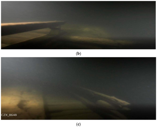
Figure 38.
Underwater photos of the wooden bridges at the Nanhu section of the Guangdong–Jiangxi Highway.
After the completion of the Xinfengjiang Reservoir (Wanlv Lake), the tributary basins of the lower reaches of the Xinfeng River and a part of the Shuangjiang–Xinggang section of the Guangdong–Jiangxi Highway were flooded. Based on the initial findings of this investigation, the submerged Guandong–Jiangxi Highway appears to be generally situated along large tributaries in the northeast of the lower reaches of the Xinfeng River. Numerous small tributaries on both sides of the river merged with it, and most of the remnants of villages and Hakka-enclosed compounds are scattered on the north side of the river. The underwater part of the Guangdong–Jiangxi Highway generally runs northeast–southwest, and the wooden bridge is at the crossing between the highway and a small river that feeds into a large northeast tributary of the Xinfeng River. Initial findings reveal that the bridge was an important node on the Guangdong–Jiangxi Highway and Ancient Road.
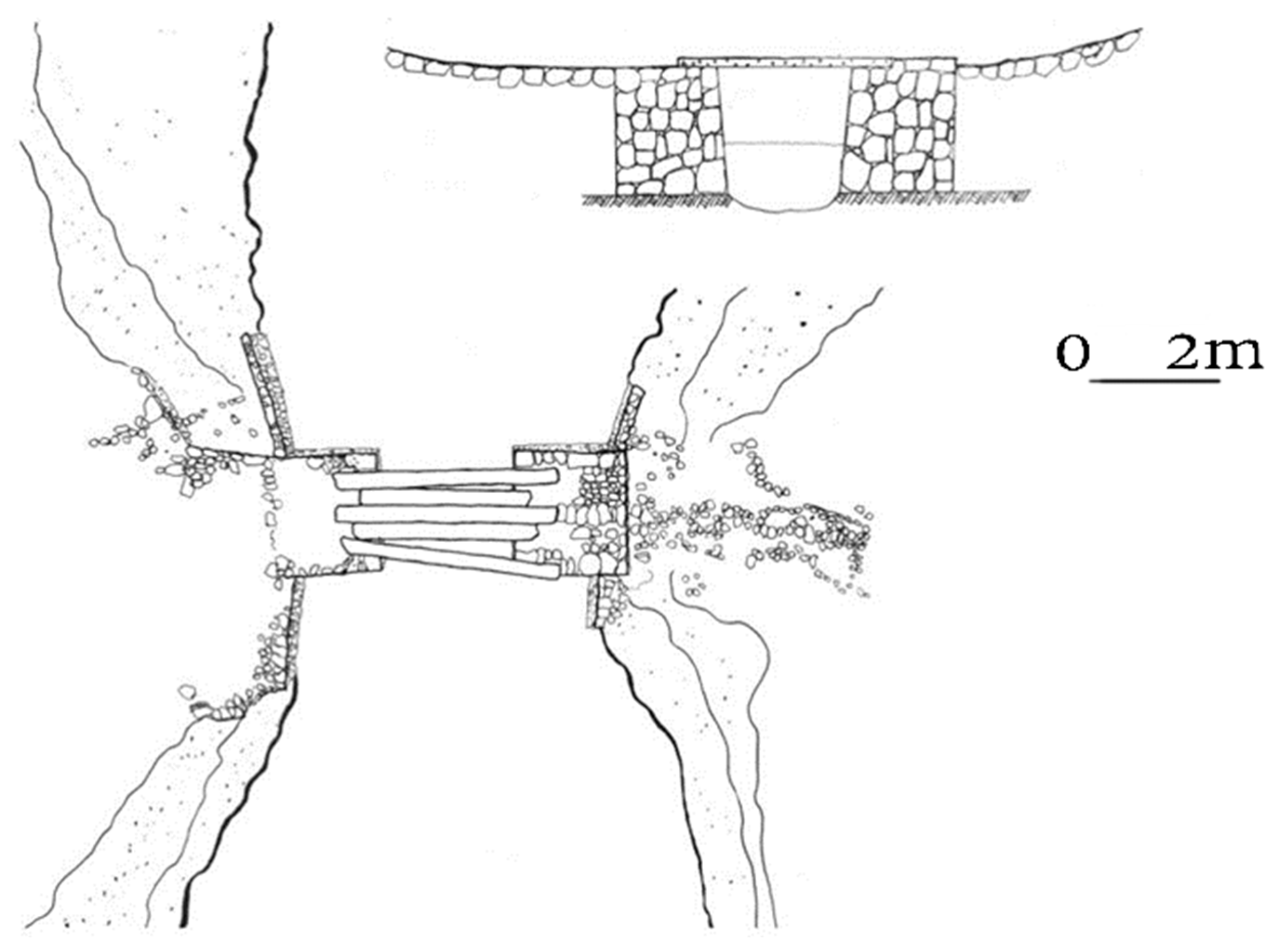
The Qingxi Stone Bridge is located south of the village committee of Qingxi Village, Xingang Town, Dongyuan County. It was revealed after the water level dropped. The Qingxi Stone Bridge is a girder-type slate bridge of modest size and spans over a creek that feeds into the reservoir. The bridge spans 2.75 m and is 1.5 m wide, featuring a surface comprising five elongated stone slabs each measuring a thickness of 18 cm, a width of approximately 30 cm, and lengths ranging from 3.4 m to 4.4 m. The stone slabs are arranged side by side on the bridge piers located on both banks. These cubic-shaped piers are constructed with stacked rocks. Each pier is 2.4 m long and 2.5 m wide, with the above-the-water portions rising to a height of 1.25 m (Figure 39). Alongside the piers on the water-flow side, remnants of retaining walls are evident. These walls were constructed with large rocks, and the remaining length of the retaining walls varies from 1.2 m to 2.5 m (Figure 40). Along the bridge side, there are remnants of pavement elevating from the northern end of the bridge, which is difficult to identify, although it is vaguely recognizable from aerial photographs (Figure 41). The length of the extended part is unknown.
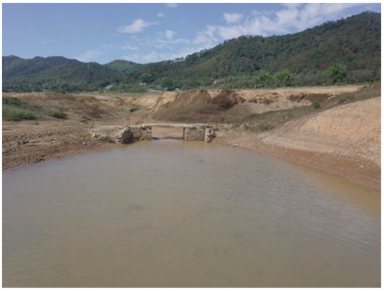
Figure 39.
Qingxi Stone Bridge.

Figure 40.
A sketch of the structure of Qingxi Stone Bridge.
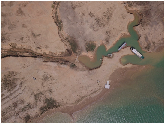
Figure 41.
An aerial view of Qingxi Stone Bridge.
The Xialin Stone Bridge is located east of Xialin Village, Shuangjiang Town, Dongyuan County, and it was revealed after the water level dropped. The Xialin Stone Bridge, which spans a tributary of the Zhongxin River, is a girder bridge with three piers. The piers were constructed with stone. The upstream side of the piers features a boat-resembling sharp shape. Stone slabs are laid horizontally to form the bridge surface, and all piers stand 3 m apart. Two layers of cantilevers are arranged on both sides of the central pier along the direction of the bridge, and one level of cantilever is added to each of the piers on the ends toward the center of the bridge to shorten the span of the bridge and enhance the bearing capacity of the bridge surface (Figure 42).

Figure 42.
Xialin Stone Bridge.
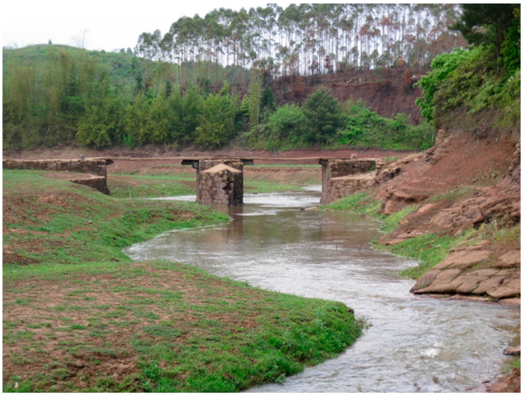
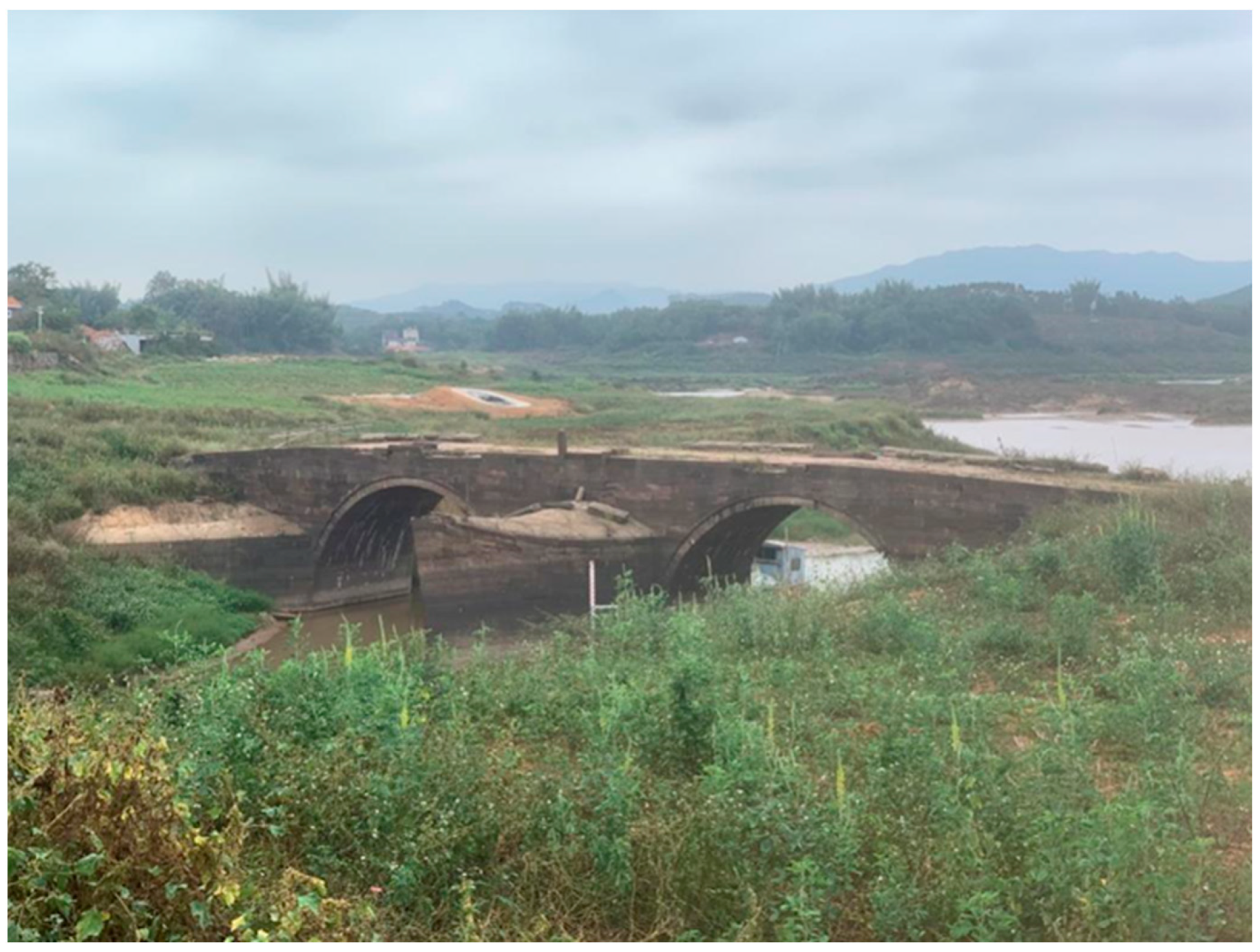
Yongding Bridge is located in Dongba Village, Jiantou Town, Dongyuan County. It was first built in the second year of the Daoguang reign in the Qing Dynasty (1822) and was completed in the fifth year of the Daoguang reign (1825). Running east–west, it is a double-arched stone bridge and has been revealed since the water level dropped. The bridge is 53 m long and 6.95 m wide. The piers and main parts are made of granite slabs with boat-shaped diversion tips. A red-sandstone bridge surface, railings, and balusters with lotus-flower decorations are seen on the bridge. The railings have collapsed due to the impact of water. Some have fallen on the bridge surface or diversion tips of the piers, while some have fallen into the river. In 2011, Yongding Bridge was accredited as a protected cultural relic of Heyuan (Figure 43).

Figure 43.
Yongding Bridge.
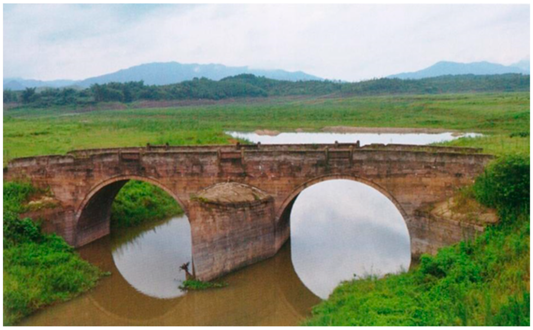
Fuxing Bridge is located above the Zhongxin River in Erlonggang Village, Shuntian Town, Dongyuan County. It was first built in the first year of the Daoguang reign in the Qing dynasty (1821) and was completed in the 13th year of the Daoguang reign in the Qing dynasty (1833). Running southwest–northeast, it is a double-arched stone bridge that used to be the only connection between Zhongxin and Heyuan. The bridge is 49.6 m long and 8.4 m wide. It is comprised of mainly red sandstone slabs, with railings, red sandstone balusters, and breast boards made of rammed earth. Two red sandstone plaques with inscriptions (“Firm Rock” and “Peace & Welfare”) are set in the center of the two balustrades. The bridge is now covered with concrete (Figure 44).
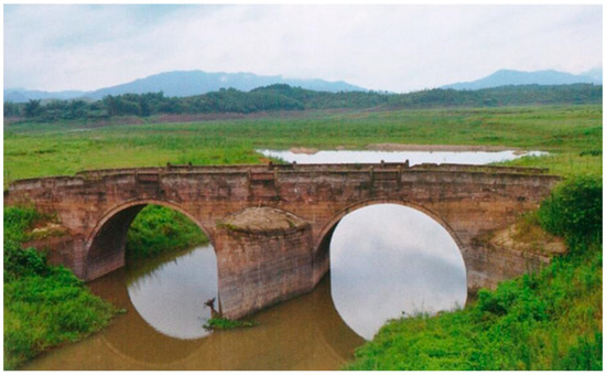
Figure 44.
Fuxing Bridge.
2.5. Survey of Other Underwater Relics
2.5.1. Towns and Villages
When the Xinfengjiang Reservoir was completed, the three ancient towns of Xichang, Huilong, and Nanhu all became submerged. During this investigation, we focused on Nanhu, Xichang, and Huilong to conduct sonar detection of the flooded area and found a dense area of these three ancient towns. All these ancient towns were adjacent to the ancient river channels, distributed in the secondary terraces of these channels. During the process of tracing the river, we also discovered two other towns, Guling and Lixi, which were not recorded in historical maps.
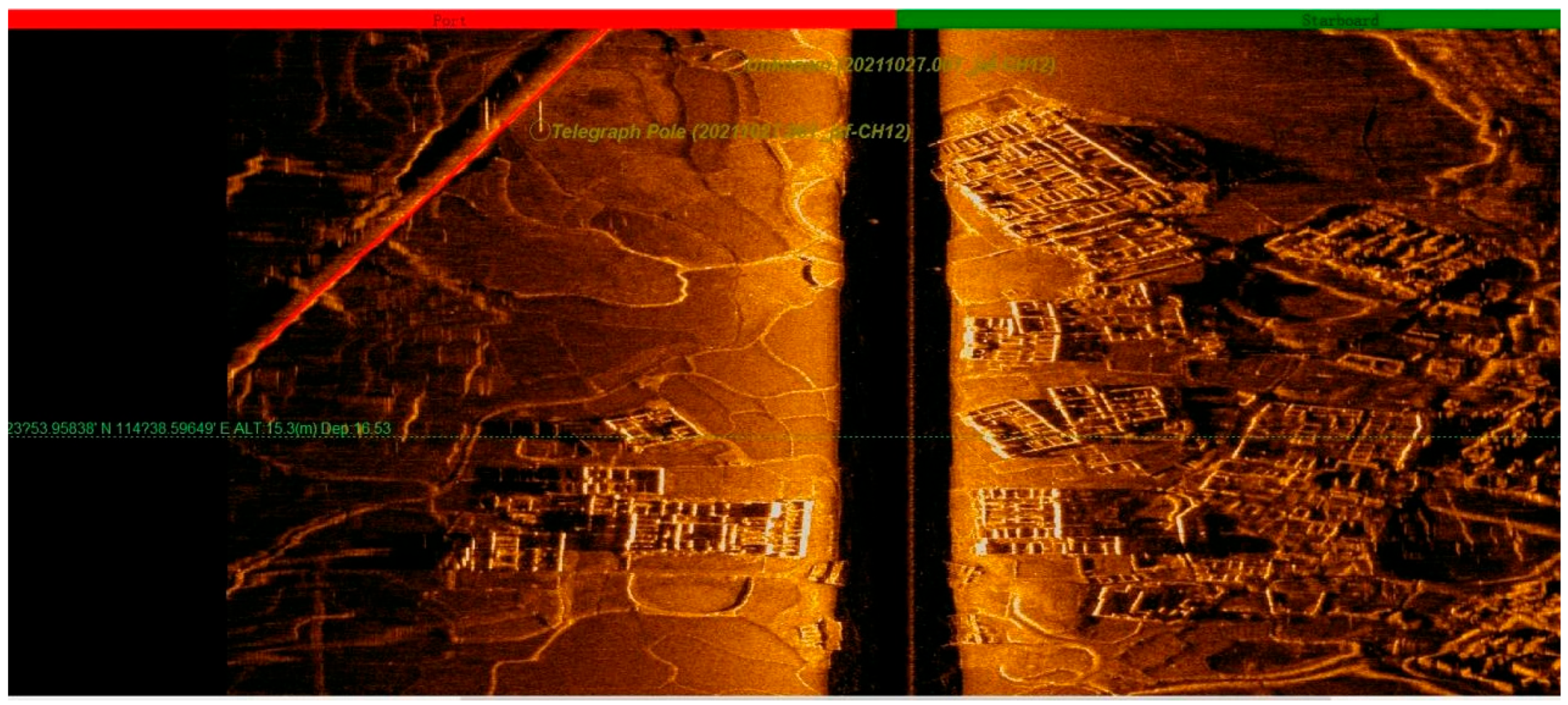
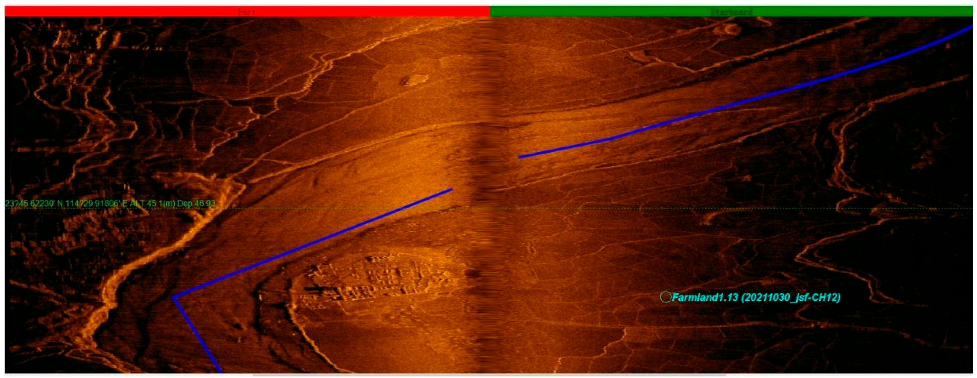
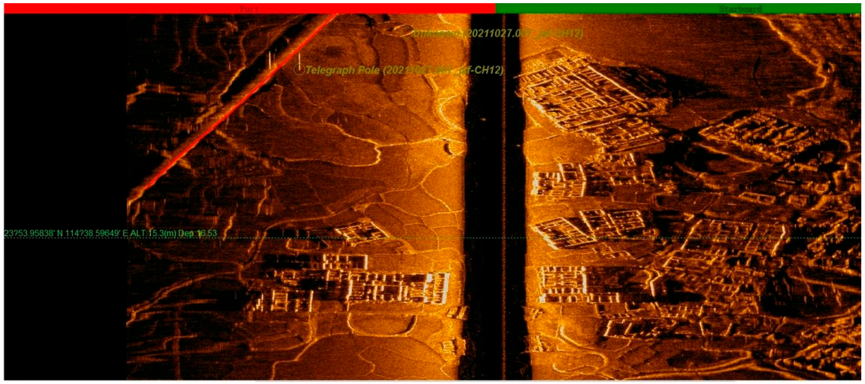
The Nanhu ancient town (23°754.01336′ N, 114° 738.72153′ E) was the largest, with many Hakka-enclosed compounds and other buildings through which the Guangdong–Jiangxi Highway passed. The Xichang ancient town (23°750.07823′ N, 114°726.39130′ E, Figure 45) resided on one side of the Xinfeng River. The Huilong ancient town (23°751.0879′ N, 114°737.3729′ E, Figure 46) spread on both sides of the Xinfeng River. The Guling ancient town (23°245.5820′ N, 114°730.14899′ E, Figure 47) was located at a turn of the Guling watercourse. The Lixi ancient town (23°749.86172′ N, 114°725.77320′ E, Figure 48) was located in a valley, with its buildings spreading from the bottom toward the mountain side. All these ancient towns were connected by the country lanes around them (Figure 49).
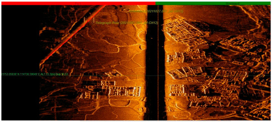
Figure 45.
A sonar map of Nanhu Ancient Town.
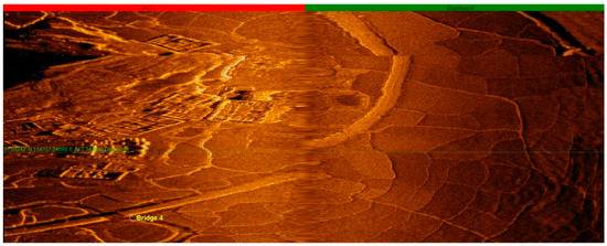
Figure 46.
A sonar map of Huilong Ancient Town along the Huilong River channel.
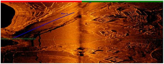
Figure 47.
A sonar map of Xichang Ancient Town.
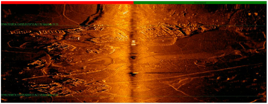
Figure 48.
A sonar map of Lixi Ancient Town.
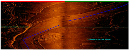
Figure 49.
The Lixi Ancient Town along an ancient river channel in Lixi.
Before the reservoir started power generation, a total of 184,500 residential buildings were demolished. At present, most of the underwater buildings are damaged to varying degrees, with most of their roofs and walls missing. These residential buildings can only be learned about through the remaining wall foundations and some of the residential buildings that underwent less demolition. The projected layout of the buildings is evident through a sonogram, which clearly shows the scale and layout of the buildings. Consequently, we have discovered Hakka-enclosed houses and sijiaolou buildings located in various towns and villages (Figure 50).

Figure 50.
The Guling town whose buildings were distributed along the Xichang waterway.
Through underwater operation, we basically confirmed the locations of Nanhu, Huilong, Xichang, Guling, and Lixi through water operation, and we developed a certain understanding for the siting, layout, and architectural forms of the submerged settlements. The villages and towns were all built on secondary terraces near the rivers, which shows the important role of water transportation in the formation of these settlements. In the expansive valley regions, there tended to be extensive farmland, often accompanied by occasional villages situated on level ground near the river. These villages were encircled by vast stretches of agricultural fields. In the narrower valley areas, however, the flat spaces near the river were predominantly comprised of farmland. Villages in these areas tended to be closer to the hillsides, featuring terraces on the steeper terrain. The higher the terraces ascended, the more orderly they became, resembling the structured layout of a tea farm. The basic logic of land use in the mountainous river valleys can be seen. Cultivated land and dwellings formed the village settlements, while a large area around the turning point of a river was the main factor for the formation of towns.
The location of these villages near water made them a representation of the successful trade along the Dongjiang River, and Linzhai Village in Heping County of Heyuan, which remains well preserved, serves as a testament to this historically significant developmental phenomenon along the upper reaches of the Dongjiang River. Throughout the Ming and Qing dynasties, Linzhai flourished due to its trade in mountainous products. One can imagine that, prior to the Xinfengjiang Reservoir’s construction, the landscape featured wider rivers, vaster plains of fertile land, a closer proximity to the Dongjiang River’s main channel, and larger architectural complexes. These factors all contributed to the prosperity of ancient towns such as Nanhu, Hailong, Xibang, Lixi, and Guling.
2.5.2. Villages, Farmlands, and Tea Farms
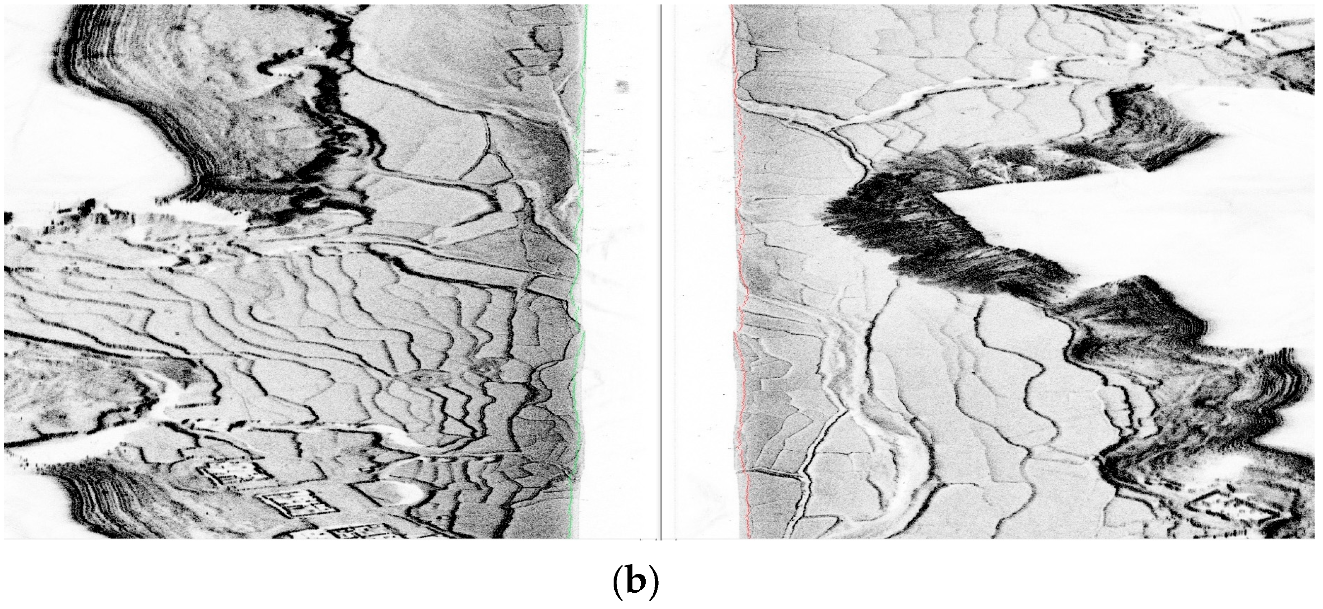
According to the sonar results, we can see that open river-valley areas were flanked by flat areas. These areas were mainly developed into farmlands. Occasionally, some villages were built on these flat lands close to the river, as they were surrounded by expansive farmlands. In narrower river-valley areas, the flat areas close to the river were mostly farmland. Villages were placed closer to the hillside, and terraces were found where the terrain was steeper (Figure 51). The higher the terraces were, the more organized they became, presenting the texture of a tea farm [6].
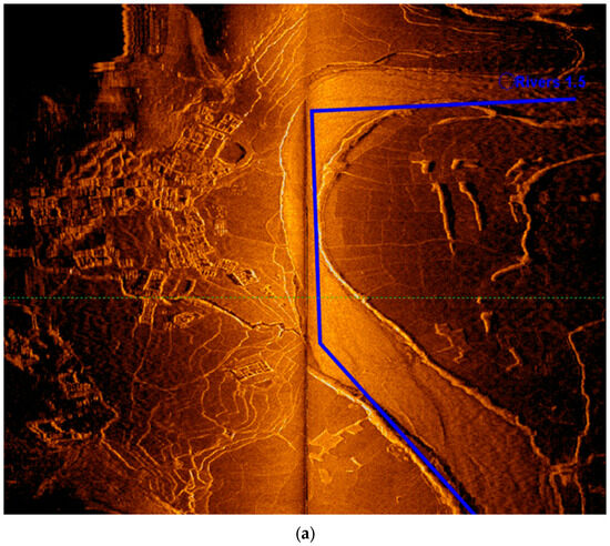
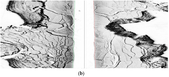
Figure 51.
Continuous paddy fields on river terraces and tea farms close to mountain ridges.
2.5.3. Hakka Residential Houses
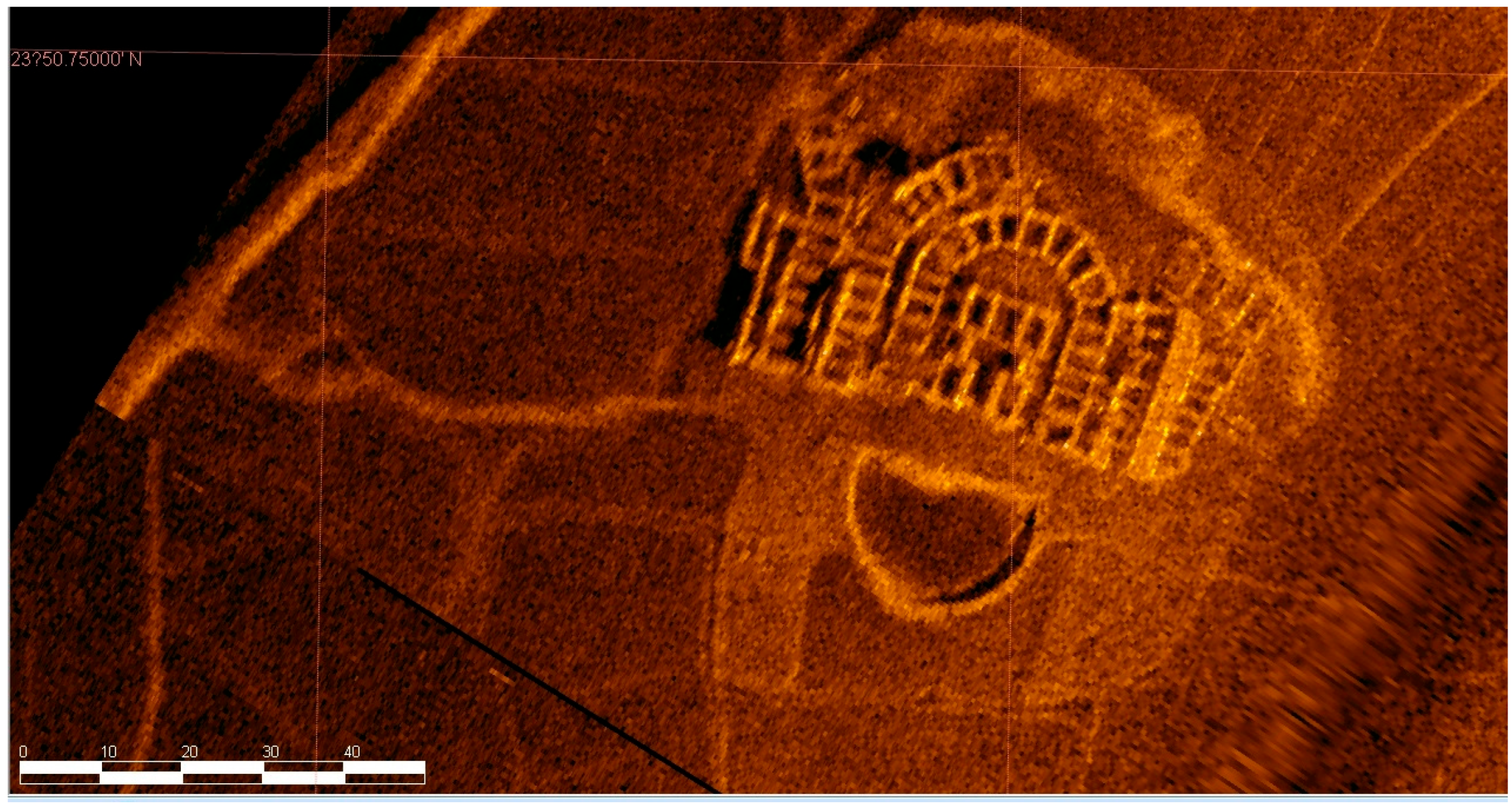
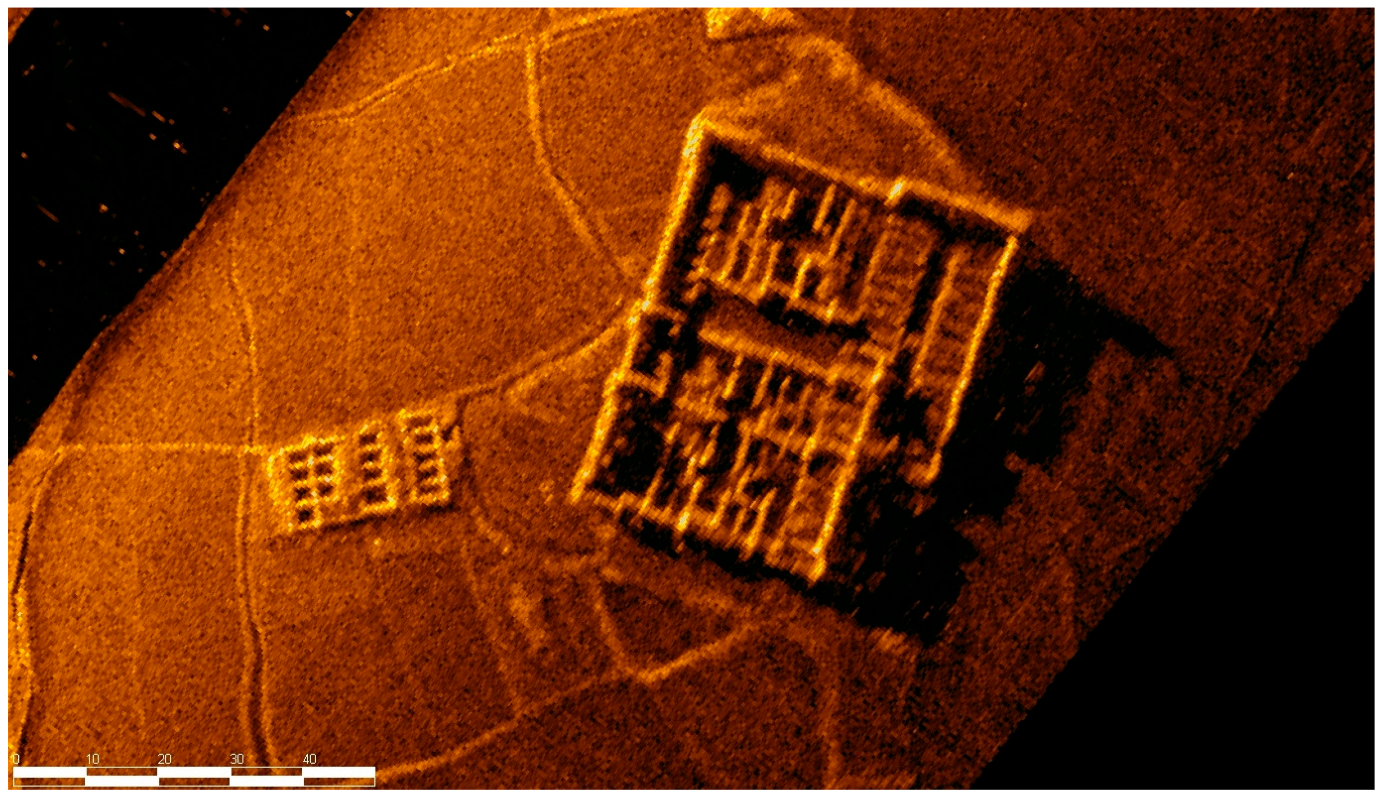
From the sonar-detection imagery, we can find that many Hakka-enclosed compounds and sijiaolou buildings existed in the submerged towns and villages. From the sonar imagery, we can identify the iconic half-moon-shaped ponds in front of the enclosed compounds [7], oblong enclosures, and well-organized rooms (Figure 52). Unfortunately, most of the buildings are only left with walls or wall foundations as their roofs are all gone (Figure 53).
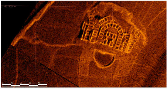
Figure 52.
A Hakka-enclosed compound.
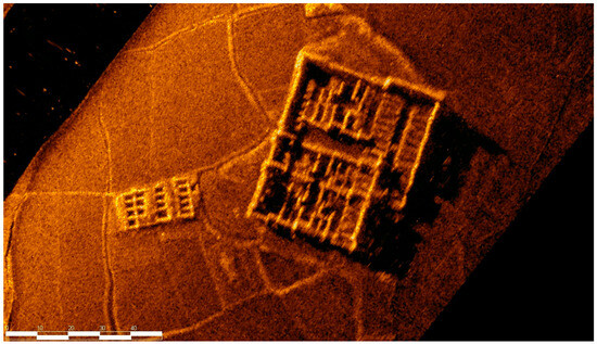
Figure 53.
Hakka sijiaolou buildings.
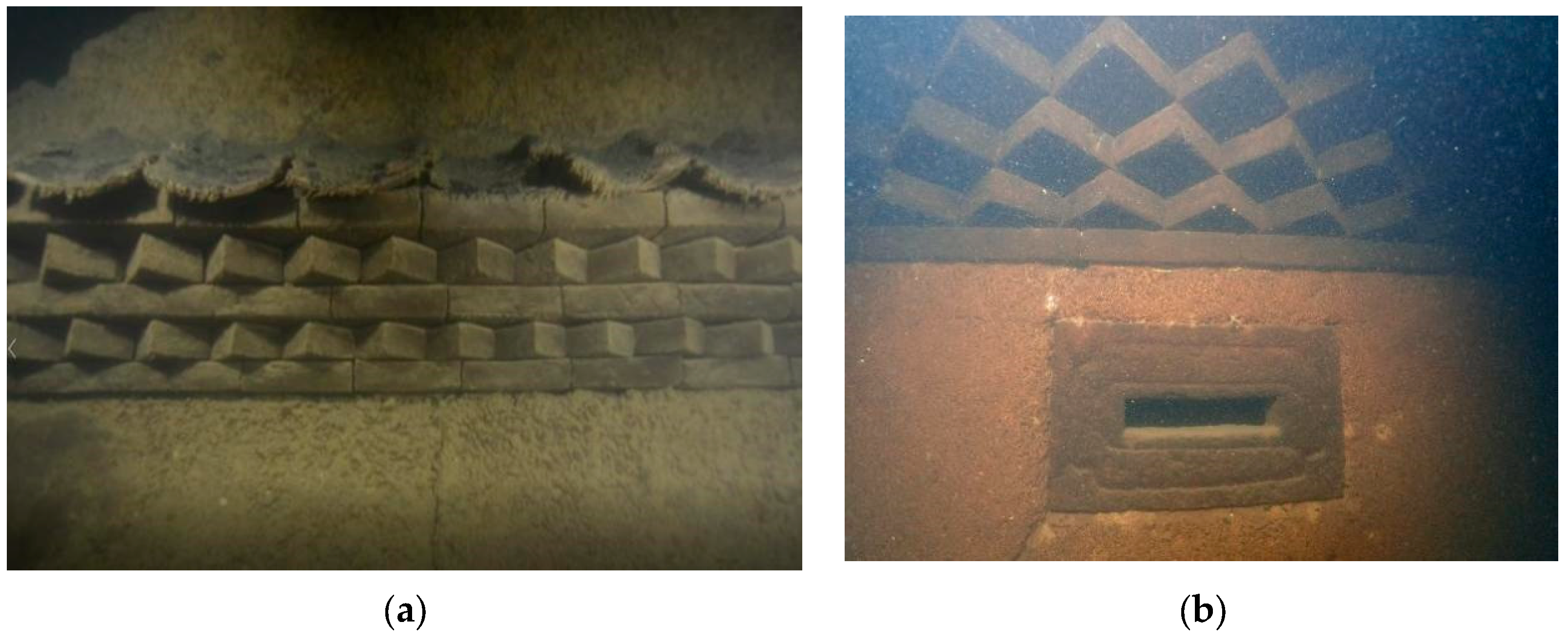
The villages and market towns are dotted with many Hakka sijiaolou buildings. Initial findings from sonar detection showed that certain parts of the walls were preserved. Thus, we arranged for underwater archaeologists to dive into the water for further examination. Through the underwater survey, we found that the roofs of most of the sijiaolou buildings were demolished (Figure 54). Because the walls were mostly made of rammed gray sand with higher solidness, some were retained. From the remnants of these walls, we can see that the original building had wainscoting made of rock slabs. The walls had several defensive gunshot and ventilation holes, and the four corners of each building were all tilted (Figure 55, Figure 56 and Figure 57). These were all iconic features of a typical Hakka sijiaolou building [8]. These Hakka dwellings with sijiaolou towers are different from the surrounding Hakka dwellings in Meizhou, Ganzhou, and Longyan [4]. They carry the typical features of Hakka architecture along the Dongjiang River, and once again demonstrate that the customs of the Hakka people near the Dongjiang River are distinct from their counterparts in neighboring areas. This is closely related to the commercial development in the area and need to store goods, displaying a strong geographical feature.
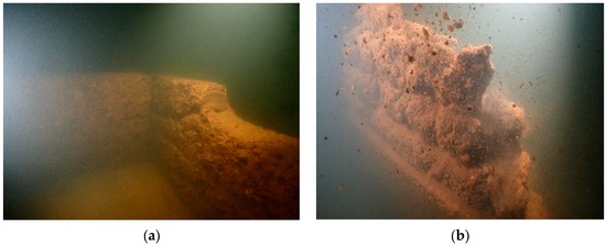
Figure 54.
Walls of enclosed compounds, which were built with rammed earth. (a) more compact. (b) less compact.
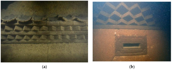
Figure 55.
(a) The gray sand wall of a sijiaolou building. (b) Defensive gun-holes on the wall of a sijiaolou building.
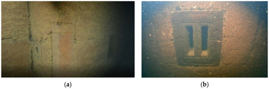
Figure 56.
The solid wall structure of a sijiaolou building constructed with rammed gray sand. (a) on the corner of the wall. (b) in the middle of the wall.
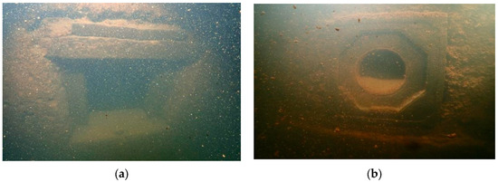
Figure 57.
Square (a) and round (b) dog holes in the lower part of a wall of a sijiaolou building.
The remaining wall constructions provide evidence that sijiaolou buildings are more solid than enclosed compounds. Most enclosed compounds were built with mud bricks or rammed earth, which explains the collapse of the remaining underwater parts. The original structure of an enclosed compound was not strong and the cost of construction was low; thus, it was suitable for members of a clan to live together therein. The walls of the remaining sijiaolou buildings were built with rammed gray sand, and the foundations and connections were mostly linked by stone structures, which imparted a strong architectural structure to these buildings (Figure 55, Figure 56 and Figure 57). Moreover, they were equipped with gun-holes, which brought high safety. Therefore, these buildings were not only functional residences, but were also safe places to store goods. These are all features of a typical Hakka residence located near a developed waterway.
3. Results: Analysis of the Findings and Archaeological Understanding
This survey’s study area included the waters of the Wanlv Lake and Dongjiang River areas in Dongyuan County, Yuancheng District, and those of Longchuan County in Heyuan, along with the road-transportation network and historical remains in the surrounding areas. We found a rich variety of historical sites, including ruins of towns and villages, architectural relics, road remains, and the historical sites of bridges, ferries, and docks. Most of them were constructed in the Qing Dynasty, and their locations were closely related to rivers and waterways. Ancient transportation in the region was mainly between Guangdong and Jiangxi, with both waterways and land routes running in parallel and connecting with one another. Additionally, the distribution of docks was relevant to the existence of ancient towns.
Due to the time limit, research scope, and depth of the survey, we can still not comprehensively recognize the transportation situation in the Dongjiang River Basin and around Wanlv Lake in Heyuan following the Qing Dynasty through this single study. However, based on the current findings and reexaminations, we have obtained a preliminary understanding of this topic. Our conclusions are as follows:
- We have established historical transportation sites, including those of ancient roads, bridges, docks, and ferries.
- We have determined the main channel and tributaries of the Xinfeng River; villages, towns, farmlands, and tea farms distributed along the main channel and tributaries of the Xinfeng River.
Regarding the status of the water system (mainstream and tributaries of the Xinfeng River) within the flooded area beneath Wanlv Lake, there were only vague sketches or simple descriptions in the past. Through this survey, we obtained a clearer understanding of this topic through underwater exploration. The Xinfeng River ran southeast from Xinfeng County of Shaoguan into Dongyuan County of Heyuan. After merging with the Zhongxin River, it ran to the south and converged with other waterways, including the Lixi waterway from the southwest, Guling waterway from the west, and Nanhu waterway from northeast, before finally feeding into the Dongjiang River in the east. The sonar detection of the status of the waterways and the existing literature can be mutually corroborated. In addition, sonar maps show that these waterways, including those of Nanhu, Guling, and Lixi and lower reaches of the Xinfeng River, all feature widths of more than 60 m, with a maximum width of nearly 100 m, and water depths of more than 4 m. In ancient times, these waterways were very suitable for water transportation. The detection found few land routes, demonstrating that Xinfeng River was the main support for the regional trade and commerce in Heyuan. On the banks of the waterways, where the five towns were distributed, there were flat and open valley areas with fertile farmlands suitable for human habitation and reproduction. These factors provided natural conditions for the region to become a “land of fish and rice”. Meanwhile, in areas closer to the upper reaches of the Xinfeng River, the river channel grew narrower and was flanked by steep slopes and dense forests on both sides. Traditionally, people residing in these areas mainly lived on cutting wood and rowing bamboo rafts.
Regarding bridges, docks, and ferries, this survey found that they all had certain patterns and characteristics. Two types of bridges were found: double-arched bridges with larger spans of over 50 m, and stone and wooden bridges spanning no more than 10 m. There are also two types of docks and ferries: those that served for travels cross the river, and those that served for passing vessels. The former constituted a major part of the discoveries. They were mainly located along the Dongjiang River to provide transportation between the banks and serve to load and unload large quantities of goods. The latter involved only one site, the Ancient Temple Dock at Sujiawei. From the type and distribution of bridges, ferries, and docks in Heyuan, these structures mainly served to connect water transportation with land transportation by satisfying the needs to travel across rivers, although some of them were part of the Dongjiang River shipping system.
In light of the relationship between ancient roads and rivers, we find that Heyuan not only had rivers with large water flow, including the larger Dongjiang River and smaller rivers such as the Xinfeng River, but it also boasted a very dense network of waterways, coupled with multiple hills and mountainous terrains. With this unique natural geography, the ancient roads had a very close relationship with the rivers. The survey reveals a distinctive transportation landscape in Heyuan, emphasizing the integration of land and water transportation—a fresh perspective that transcends the traditional notion of parallel land and water routes prevalent in the past. Given the navigability of the Dongjiang, Xinfeng, and Zhongxin rivers, water transportation in valleys and their surrounding areas was more common. In the mountainous and hilly areas, although there were many small tributaries that could eventually converge into the Xinfeng and Zhongxin rivers, transportation mainly relied on land routes because those small tributaries were not navigable. Thus, the combination of land routes in mountainous areas and water routes formed a transportation network with both land and water transportation. In the gently sloping river valleys, the connectivity between roads and rivers was evident. In mountainous regions, ancient roads consistently connected with bridges, docks, and ferries to establish connections between land and water routes.
Regarding the submerged area beneath Wanlv Lake, through the relevant literature, we learned that the Xinfengjiang Reservoir had drowned many towns and villages. In this survey, we used underwater operation and basically confirmed the locations of Nanhu, Huilong, Guling, and Lixi ancient towns, and developed a basic understanding of the siting, layout, and architectural form of the submerged settlements. These towns were all located on expansive plains near wide rivers, highlighting the importance of water transportation to these settlements. In the expansive valley regions, there tended to be extensive farmland, often accompanied by occasional villages situated on level ground near the rivers. These villages were encircled by vast stretches of agricultural fields. In the narrower valley areas, however, the flat spaces near the river was predominantly comprised of farmland. Villages in these areas tended to be closer to the hillsides, featuring terraces on the steeper terrain. The higher the terraces ascended, the more orderly they became, resembling the structured layout of a tea farm. We can see that the basic logic behind the land use of river valleys around mountainous areas as arable land and residential land were the main factors contributing to the formation of settlements. In terms of architecture, there were many typical Hakka-walled houses and sijiaolou buildings, in addition to ordinary residential buildings (Figure 58).
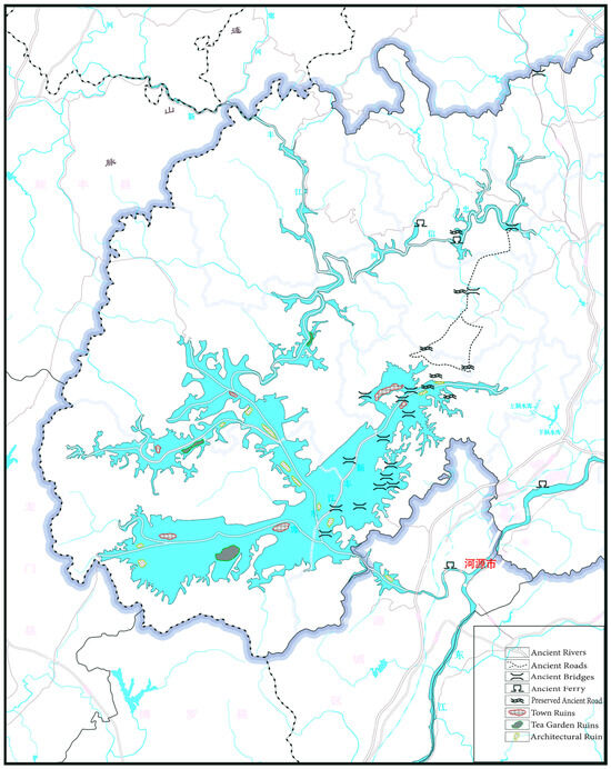
Figure 58.
A map showing the distribution of ancient ruins submerged in Wanlv Lake.
We find that most of the ancient ferries along the Dongjiang River have been covered by modern ones and are no longer traceable. This is why the ferries have been in use. Although the remains are difficult to find and the time of the construction of the ferries cannot be established, we can still report some findings. In multiple ancient sites, including Guyun, Yihe, Lankou, Liucheng, and Tuocheng South Gate Ferry, we found ancient banyan trees, which means that banyan tree was a symbol for ferries on the banks of Dongjiang River. This could be related to the traditional feng shui concept of “returning to one’s hometown in honor”.
4. Conclusions and Prospects
It is a novel approach to apply sonar detection in the scanning of submerged ancient ruins, including rivers, farmlands, villages, and towns. In this study, we have confirmed the specific locations of five ancient towns (Nanhu, Xichang, Huilong, Guling, and Lixi) and gained a comprehensive understanding of the Huilong, Nanhu, and Lixi waterways in the upper reaches of the former Xinfengjiang River. Additionally, we have established a clear path for the connections and directions of the former Guangdong–Jiangxi ancient roads and highways.
We show that sonar scanning is extremely effective in revealing and restoring scenarios of ancient human production and lives on a large scale. Additionally, it is effective in outlining regional and even trans-regional human migrations and trading activities.
To collect further detailed information about underwater remains, we can adopt synthetic-aperture and multi-beam scanning for data collection, and establish a three-dimensional database to specify information about underwater ancient architectural sites and the remains of ancient river channels. This would help us discover more archaeological details, as this approach would deepen the understanding of history and culture.
Author Contributions
Conceptualization, S.Z. and M.H.; methodology, G.D. and X.W.; software, X.W.; validation, S.Z. and M.H.; formal analysis, S.Z., M.H. and X.W.; investigation, S.Z., M.H., G.D. and X.W.; data curation, S.Z., M.H. and X.W.; writing—original draft preparation, S.Z., M.H. and X.W.; visualization, S.Z. and X.W.; supervision, S.Z. and M.H.; project administration, S.Z. and M.H.; funding acquisition, S.Z. and M.H. All authors have read and agreed to the published version of the manuscript.
Funding
This research was funded by the Southern Marine Science and Engineering Guangdong Laboratory (Zhuhai) (SML2020SP006).
Data Availability Statement
The datasets used and/or analyzed during the current study are available from the corresponding author on reasonable request.
Acknowledgments
We would like to acknowledge the support of Wanlv Lake Scenic Area Management Committee, who assisted us in collecting underwater data. All authors thank the reviewers for their comments, which contributed to a better paper.
Conflicts of Interest
Author Dong Guoliang was employed by the company Guangzhou Longde Diving Inc. The remaining authors declare that the research was conducted in the absence of any commercial or financial relationships that could be construed as a potential conflict of interest.
Notes
| 1. | Wang Yuanlin: The Ancient Road of Longchuan. |
| 2. | Same as Note 3. |
| 3. | Tan Weilun and Zeng Hanxiang: Traditional Society and Local Customs in Heyuan. |
| 4. | According to page 49 of the “Investigation Report of Guangdong-Jiangxi Ancient Road” compiled by the Guangdong Province Nuclear Industry Geological Bureau’s 292nd Brigade, “three sections of well-preserved ancient roads have been found in Dou’ao and near the Xinfengjiang Reservoir, with their lengths ranging between 150 and 500 m and widths up to 2 m”. This ancient road is called the “Dou’ao Ancient Road”. After the water level dropped, the ancient road originally submerged underwater was exposed. The original joint between the ancient road and the lake was also found near the current lake. |
| 5. | A photo of the Doubei Village Ancient Road could be found on page 50 of the “Investigation Report of Guangdong-Jiangxi Ancient Road” compiled by the Guangdong Province Nuclear Industry Geological Bureau’s 292nd Brigade. From the photo, it could be seen that the road shared an identical pavement approach with the water entry point of the Dou’ao Ancient Road, with slight differences in the width. The two roads are not far from each other, and should belong to the same road section constructed in the same period. |
| 6. | The place where the “Yuantan Ferry Stele Inscription” was found is not far from the Dongping Ancient Road near the ruins of a village very close to the river. |
| 7. | According to the “Investigation Report of Guangdong-Jiangxi Ancient Road” compiled by the Guangdong Province Nuclear Industry Geological Bureau’s 292nd Brigade, the main road of Guangdong–Jiangxi Ancient Road in Heyuan generally runs in a north–south direction. It leads from Heping in the north to Lianping in the south, arriving at the urban area of Heyuan after passing through the three towns of Shuntian, Jiantou, and Shuangjiang of Dongyuan. Both the main route and the branch lines of the Ancient Road passed through Shuangjiang. Judging from its location, the Xialin Ancient Road should belong to the main route. |
| 8. | The Chronicles of Heyuan, compiled by the Heyuan Local Chronicles Editorial Committee. |
| 9. | From the topography and the remains of the site, a preliminary judgment could be made that this place used to be a dock; however, additional evidence is required for verification. |
| 10. | In the Qing Dynasty, Chen Zhangyi of Heyuan County wrote a poem titled “Longjin Evening Ferry”: “A river surrounds the city with the ancient ferry of Longjin. At sunset, boats float on the river. Across the bank, porters are climbing the mountain wearing bamboo hats. Don’t eulogize sufferings. Let’s unite with each other to reach our destination”. |
| 11. | “Guyun” is an ancient name. According to a copy of “The Chronicles of Heyuan County: Volume 15,” compiled by Peng Jungu and edited by Lai Yiping, published in the 13th year of the Tongzhi reign in the Qing dynasty, Guyuan is located 20 lis away from the downtown to the east. |
| 12. | According to a copy of “The Chronicles of Heyuan County: Volume 15”, compiled by Peng Jungu and edited by Lai Yiping, published in the 13th year of the Tongzhi reign in the Qing dynasty, the Liucheng Ferry was located to the northeast of downtown Heyuan with a distance of 120 lis. Situated in Liucheng town, it was initiated by Chen Zixue with a rent of over 90 dans. With an approval from the county’s head official surnamed Wang, a stele was set up on the left side of the Tianhou Temple. |
References
- Leong, S.-T.; Wright, T.; Skinner, G.W. Migration and Ethnicity in Chinese History: Hakkas, Pengmin, and Their Neighbors; Stanford University Press: Redwood City, CA, USA, 1997. [Google Scholar]
- Campbell, G. Origin and Migration of the Hakkas. Chin. Rec. 1912, 43, 473–480. [Google Scholar]
- Xie, G.; Zhou, Y.; Liu, C. Spatial distribution characteristics and influencing factors of Hakka traditional villages in Fujian, Guangdong, and Jiangxi, China. Sustainability 2022, 14, 12068. [Google Scholar] [CrossRef]
- Cervenka, P.; De Moustier, C. Sidescan sonar image processing techniques. IEEE J. Ocean. Eng. 1993, 18, 108–122. [Google Scholar] [CrossRef]
- Blondel, P.; Blondel, P. Sidescan sonar data processing. In The Handbook of Sidescan Sonar; Springer: Berlin/Heidelberg, Germany, 2009; pp. 49–84. [Google Scholar]
- Li, F.; Lu, G.; Zhou, X.; Ni, H.; Xu, C.; Yue, C.; Yang, X.; Yang, J.; Feng, F.; Fang, F. Elevation and land use types have significant impacts on spatial variability of soil organic matter content in Hani terraced field of Yuanyang County, China. Rice Sci. 2015, 22, 27–34. [Google Scholar]
- Lin, R.; Fan, Y.; Zhang, D. Landscape Feature Extraction and Floristic Division of Traditional Villages in the Minjiang River Basin. South Archit. 2022, 1, 54–60. [Google Scholar]
- Yang, X. Research on hakka enclosed houses in guishan county of qing dynasty. Ph.D. Thesis, South China University of Technology, Guangzhou, China, 2011. [Google Scholar]


Disclaimer/Publisher’s Note: The statements, opinions and data contained in all publications are solely those of the individual author(s) and contributor(s) and not of MDPI and/or the editor(s). MDPI and/or the editor(s) disclaim responsibility for any injury to people or property resulting from any ideas, methods, instructions or products referred to in the content. |
© 2024 by the authors. Licensee MDPI, Basel, Switzerland. This article is an open access article distributed under the terms and conditions of the Creative Commons Attribution (CC BY) license (https://creativecommons.org/licenses/by/4.0/).