Abstract
This study explores the synergistic integration of remote sensing (RS) and Historical Landscape Characterisation (HLC) methodology as an innovative, multi-scalar and holistic approach to enhance archaeological planning. The goal is to maximize the effectiveness of the investigations, optimizing data collection and improving the contextual understanding of the sites. In fact, these methodologies can significantly contribute to the documentation, conservation, planning and valorisation of archaeological areas. By integrating RS data with features detected by HLC, a complete picture is obtained that facilitates a deeper understanding of the landscape and historical dynamics. This article will explain the combined approach of RS and HLC, presenting some methodologies key to improving the precision and effectiveness of archaeological planning. This integration facilitates the sustainable preservation of archaeological resources and contributes to the conscious management of cultural heritage in the context of contemporary development. The paper demonstrates, through a case study, how the application of the two methodologies (RS and HLC) in an integrated form can provide an exhaustive interpretation of the territory in which the archaeological area is located, which can represent an exhaustive knowledge base on which to set up effective processes for the strategic territorial planning of archaeological areas.
1. Introduction
Historical Landscape Characterisation (HLC) is a spatial reading method that is used to understand and represent landscapes with particular reference to their historical development [1]. This methodology was modelled by English Heritage in the early 1990s [2] and is mainly applied in England, although very similar methodologies are becoming increasingly common in other parts of Europe [3].
The particularity of the method lies in the fact that instead of mapping individual archaeological sites, it attempts to interpret the entire landscape as a continuous cover based on changes in historical development [4].
Landscapes change over time, deriving their shape and typicality from human actions and the natural processes of the past and present; this is also why they are very complex spatial forms with many thousands of individual physical elements that can be interpreted with a range of different values in the past and present, and with different perspectives for the future [5,6].
Therefore, the analysis of evolutionary dynamics entails the examination of those signs that human activity has imprinted on the territory: land use and the shape of plots of land, the distribution of settlements and population, the deployment of the infrastructure and transport network, the articulation of the administrative grid, the relations between productive structures, and so on.
The HLC recognises that all parts of the landscape have historical significance as a result of human activity and use over millennia [7].
The HLC maps the ‘types’ of character, bringing the historicity of the landscape into the foreground by presenting its present-day character in the light of the ‘long chain’ of events in history [8]. The HLC, based on the assumption that the landscape is the result of the combination of different forms of social, economic, legal and political–administrative organisations which have shaped an area and its multiple components over time, thus emphasises the diachronic aspect. In this sense, the landscape represents the material translation of the relations that have developed, over time, between a human group and its environment, whereby the set of physical elements, and the signs left by man through the transformative activities of the natural elements, define the identity of a place. Furthermore, the method is very flexible; it can be modified to adapt to variations in the nature of local landscapes or to the objectives of a project [7].
The use of satellite remote sensing (RS) in archaeological research dates back to the second half of the last century [9]. More recent, i.e., dating back to the 1970s, are the aerial platform surveys carried out using hyperspectral scanners, to which the Multispectral Infrared and Visible Imaging Spectrometer (MIVIS) sensor belongs [10,11].
In Italy, the MIVIS airborne hyperspectral sensor was first employed in the archaeological field by the CNR LARA (Laboratorio Aereo Ricerche Ambientali del Consiglio Nazionale delle Ricerche), which started a research programme in 1994 on the archaeological areas of Selinunte [12] and Marsala. Since 1999, other areas in Sicily have been affected by the application of MIVIS in archaeological research such as Alesia, Mozia, Piazza Armerina, Soriana and later, in 2005, in Apulia in the archaeological area of Apri and Siponto, and in northern Italy starting in 2002 in Piedmont along the Po valley and Friuli Venezia Giulia in Aquileia [13].
Today, thanks to the good availability of high-resolution satellite images, remote sensing is one of the most powerful tools for low-cost surveys in the archaeological context [14,15,16]. This is also because we are in the presence of a landscape that is rapidly changing due to strong human impact [17,18], and, very often as a result of this, archaeological evidence is erased and/or buried very quickly. In particular, in Mediterranean coastal areas, which are critical areas of investigation because, they are affected by erosion, desertification, rapid agricultural development more than the others, and at the same time, historically, they are custodians of an enduring synergistic relationship between landscape, ancient cultures and societal evolution [19,20], which seem to be endangered today with a serious impact on archaeological remains. More heavily, it has also sometimes happened that the change in the use of some areas facilitated by mechanical means, for agricultural purposes or construction or other, has destroyed several archaeological sites, levelling their original relief forms. The use of remotely sensed digital imagery allows for the elaboration of predictive models, in an attempt to interpret the spatial distribution of unknown sites and to identify areas where the probability of locating ancient settlements is highest [21,22]. Furthermore, the identification on hyperspectral images of surface traces and anomalies, further investigated by measuring the physical properties of soils and vegetation, can be related to the presence of buried archaeological deposits [13].
Finally, the GIS, where both the surveys carried out with the HLC and RS methods converge, becomes a useful system for managing and integrating the different remote sensing data and the information extracted from it, such as the historical and landscape interpretations and any other data useful for configuring a predictive model implemented for the location, conservation, planning and management of archaeological areas [23].
The integrated methodology that combines HLC and RS aims to offer a detailed and comprehensive view of landscape variations, facilitating the detection of archaeological features and investigations to discover the presence of possible finds underground. In this sense, the aim is to fill some specific gaps in archaeological research, which in most cases has either investigated and then made assumptions in the area covered by archaeological excavations without considering a wider reference territory, or has referred to more or less in-depth analyses of land use but never in a historical–diachronic form. Therefore, considering the specific limitations of current methodologies, it is hypothesized that this type of experimental approach, based on the synergic use of HLC and RS, can improve the effectiveness and accuracy of archaeological planning by significantly contributing to the sustainable conservation of archaeological resources and the management and enhancement of archaeological sites.
2. Materials and Methods
2.1. Methodology
In more detail, HLC is carried out by examining the current landscape through the use of maps, aerial photographs, or other sources, and characterising it according to particular component patterns into landscape ‘types’. These types are usually defined prior to mapping [23,24].
The mapping in the specific case of the archaeological area of Caulonia in the Calabria Region was carried out using Quantum GIS software, and the data for each individual block of a specific landscape character ‘type’ were recorded using a Microsoft Access database. A number of sources, such as maps from the Military Geographical Institute of Italy, digital orthophotos, historical and modern maps, and vertical colour aerial photographs, were used to inform character mapping. Some other data sets were also used, where available, e.g., the detailed survey of the Strategic Plan, and, as far as possible, the number of different HLC types was kept to a minimum. HLC ‘types’ were then assigned on the basis of similarities with the case studies, and recorded in the database together with ‘morphological’ information on each block of each character type.
In particular, land cover variations were considered for the following macroclasses: 1. Artificially modelled territories; 2. Agricultural territories; 3. Wooded territories and semi-natural environments; 4. Vacant areas; 5. Areas with buildings.
In addition, an analysis of the changes in land area was carried out, through the intersection of the vector data for 1938 and 2024, two different time thresholds, the land areas subject to land cover transformations in the considered interval were identified. From these, transition matrices were derived, from which the source and target land use classes can be known.
All of these data are then available to be analysed and to chart trajectories of change in the future, as it allows us to see the links between landscapes of different periods, in which sense landscape archaeology can play an important role in informing spatial planning by helping to guide change in the future [23].
The remotely sensed data make use of MIVIS technology, i.e., a simultaneous hyperspectral imaging system operating in the regions of the electromagnetic spectrum from visible to thermal infrared, with high spectral resolution.
More specifically, MIVIS has a modular electro-optical sensor consisting of 4 spectrometers that simultaneously capture, with an instantaneous angle of view of 2 mrad, the radiation coming from the Earth’s surface in the visible wavelengths (20 bands between 0.43–0.83 pm) in the near infrared (8 bands between 1.15–1.55 pm), in the mid-infrared (64 bands between 2.0–2.5 pm) and in the thermal infrared (10 bands between 8.2–12.7 pm) for a total of 102 bands that allow for image composition in both real RGB colours and false colours [25,26].
The MIVIS hyperspectral images were acquired in 2011 as part of the Simona project of the CNR Institute of Air Pollution [27].
To highlight the surface inhomogeneities present on the images, due to variations in texture, humidity and vegetation cover induced on the surface by the presence of underlying structures, different hyperspectral data processing procedures were used: the transformation technique (Minimum Noise Fraction and Principal Components Analysis (MNF and PCA), the Spectral Angle Mapper (SAM) classification, and the NDVI Vegetation Index.
The photo-interpretative analysis of the archaeological site of Caulonia takes into consideration the presence of areas of differentiated humidity, which appear with a different colouring on the image, such as the vegetation cover that grows more luxuriant and greener where more humus and greater humidity are present, the granulometric alteration of the terrain, the slight and gradual altimetric variations that detect the presence of buried archaeological elements, as well as the presence of ancient materials in certain points of the soil.
The MIVIS images resulting from the transformation techniques of Minimum Noise Fraction (MNF) and Principal Components Analysis (PCA), and the Rules Images derived from the Spectral Angle Mapper (SAM) classification, as well as aerial photographs and orthophotos, were interpreted from an archaeological and topographical point of view.
The photo interpretation of all the traces identified was supported by accurate bibliographic research and a systematic reconnaissance of the terrain that allowed for an archaeological reading of the anomalies, and provided a great deal of information on the general situation and the individual structures of the archaeological area of Caulonia.
This methodological framework allows for a holistic understanding of landscape transformations over time.
The novelty of the approach lies in the integration of two distinct methodologies—HLC and remote sensing—into a unified framework for archaeological planning. This multi-scalar and holistic approach is innovative in its ability to provide a comprehensive understanding of the landscape and historical dynamics, thereby improving the accuracy and effectiveness of archaeological conservation and planning. In the literature, there are no existing experiences with the integration of the two methods, so this integration progresses beyond existing practices.
2.2. Study Area
Caulonia (Caulon) was founded by Achaean colonists. Between the end of the 8th century BCE. and the beginning of the 7th, the excessive proximity of larger and more powerful cities, combined with the narrowness and low fertility of its territory, severely limited its expansion. The heyday of the Achaean city must be considered the second half of the 6th century BCE when it participated in the Battle of Sagra alongside Crotone against the Locrians [28]. Historical sources speak of successive destructions (which could imply relative reconstructions): in 389 BCE by Dionysius the Elder, tyrant of Syracuse; in 280 BCE as part of Pyrrhus’ expedition against the Romans; in 209 BCE, after being the object of contention between Hannibal and Rome. Between the 1st century BCE and the 1st century CE, the Romans implanted a statio on the site—a resting/change station along the road that connected Taranto and Reggio Calabria—known as Caulon, Stilida or Cocyntum and frequented until the beginning of the 7th century CE. Its implantation was a consequence of the planning of road axes, following the Roman conquest of Bruttium (roughly present-day Calabria). New villas sprang up around the abandoned settlement, linked to the latifundary exploitation of the territory [29].
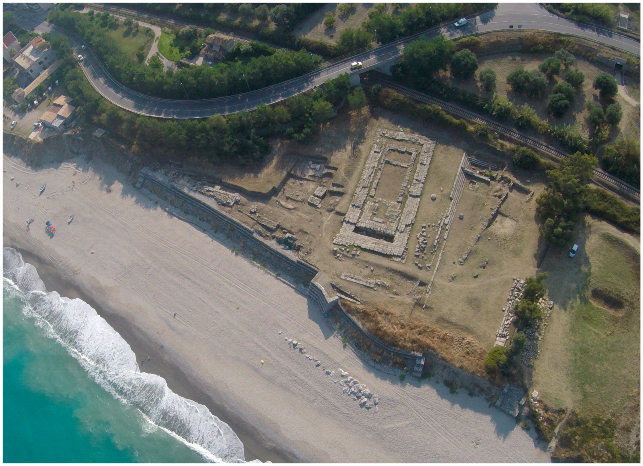
The archaeological area includes the sanctuary of Punta Stilo consisting of a Doric temple dating from around the mid-5th century BCE (Figure 1); the Casamatta, where several coins of the period were found, as well as traces of a cult to Demeter; the House of the Dragon (Figure 2), which includes the remains of a house in which a floor mosaic representing a sea dragon was found, which has become the symbol of Caulonia itself in recent years (Figure 3); the hill of the Punta Stilo Lighthouse where there are the remains of a temple presumed dedicated either to Poseidon or Apollo, and other houses such as the House of the Grotesque Character, the House of Insula I, House Guarnaccia, and House of Clete [30,31,32].

Figure 1.
Archaeological remains of the Doric temple at Punta Stilo. Aerial photo shows the location of the temple near the coastline.
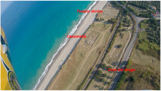
Figure 2.
Aerial view of the archaeological area of Caulonia, with the archaeological remains of the Doric temple of Punta Stilo, the remains of Casamatta, and the remains of the Dragon House. On the aerial photograph, archaeological remains are identified by their designation.
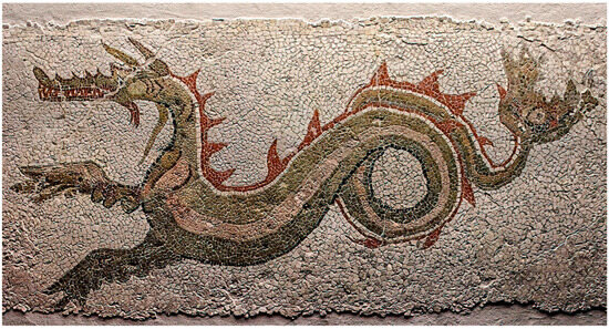
Figure 3.
Particular of the Mosaic of the Dragon House. The mosaic is part of the floor of the house.
2.3. Archaeological Research on the Site of Caulonia
The definitive identification of the ancient Achaean city of Caulonia is due to Paolo Orsi, who, in excavation campaigns from 1912 to 1915, brought to light the remains of the Doric temple and remnants of the city walls [33]. In 1959, Schmidt and Chevallier used Orsi’s aerial photographs and archaeological data to study the topography and town planning of the city. In the 1970s, research activities continued under Alfonso De Franciscis, and more intensively in the 1980s, with the start of programmatic and systematic research on the archaeological site on behalf of the Archaeological Superintendency of Calabria with the contribution of Calabrian universities, the French National Council of Research (CNRS), the Ecole Francaise, and L’Ecole Belgique in Rome [34]. Since 2003, archaeological investigations have focused almost exclusively on the city’s seafront by the University of Florence, and numerous artefacts have been found. In recent years, various structures and objects pertaining to the ancient city have been found in the archaeological area, especially from the excavations at the Doric Temple and from the excavation of Casamatta, where in 2012, an extraordinary mosaic was discovered near a monumental thermal environment dating back to the 4th century BCE. That is considered the largest and most articulated Hellenistic mosaic of the entire Magna Graecia (Figure 3), as well as the oldest in Calabria, dating back to between the end of the fourth and the first decades of the 3rd century BCE [35,36].
3. Results and Discussion
The principle on which the methodology of reading the historical landscape through HLC is based is to verify changes in land use and land cover by identifying minimum landscape units and vocational areas [24]. This is important in order to monitor future transformations of the landscape and assess the related landscape risk so that preventive actions can be implemented if necessary.
The HLC analysis considered different historical periods using historical aerial photographs from 1938 (Figure 4), which provide important information that is sometimes no longer visible on the ground today due to subsequent transformations, and Google Earth remote sensing images from 2013 to the present day 2024. At the various dates, the key recognisable features of the landscapes were identified through a comparative analysis that demonstrated the changes in land use and land cover, as well as which historical processes or practices led to their formation. The analysis was structured on a georeferenced database and was consequently mappable and analysable through GIS systems. The possibility of interrogating the data in a diachronic series made it possible to analyse the modifications of the territory over time, observing in which directions its landscape and environmental structure is evolving. This, at the same time, made it possible to identify elements of potential landscape risk deriving from the alterations of the agricultural mesh and the expansion of areas with artificial cover, as well as to show in quantitative terms the reciprocal relationship between the different land covers and therefore the balance between the different landscape elements.
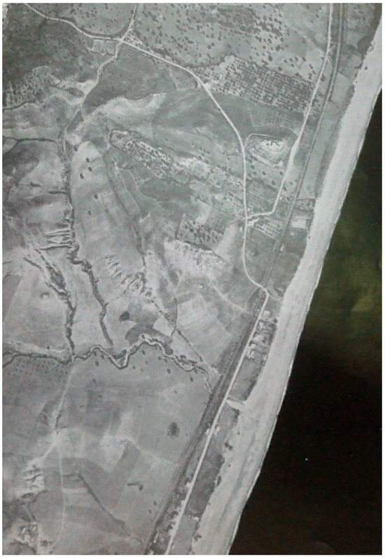
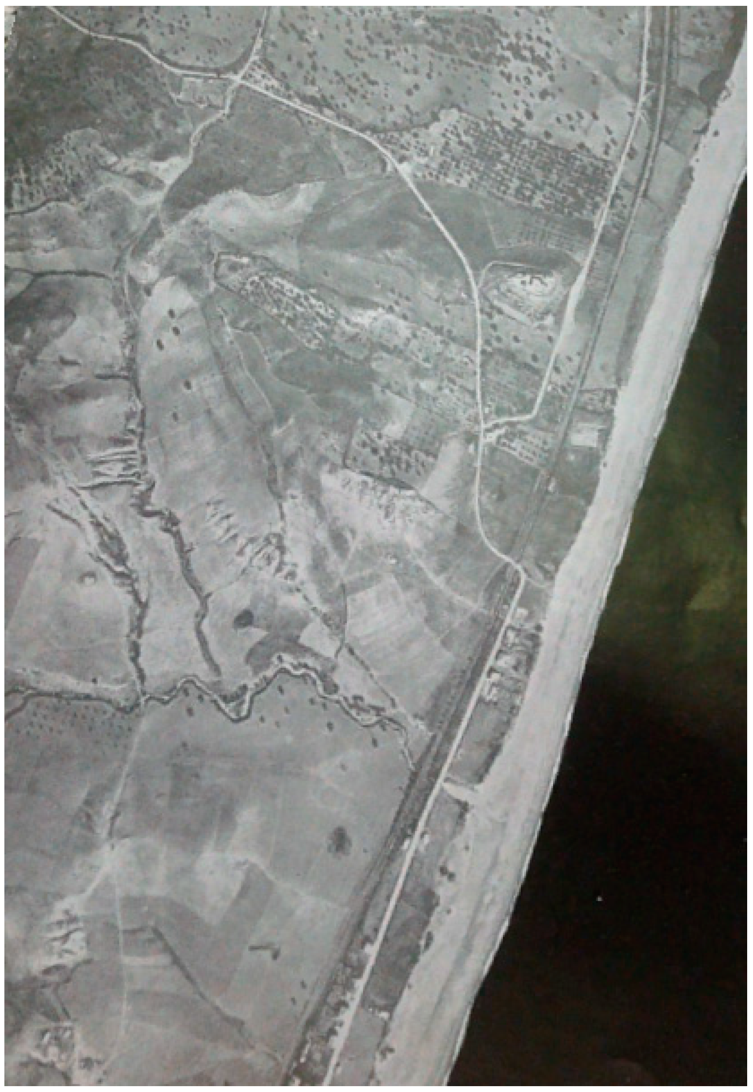
Figure 4.
Caulonia, 1938: Aerial photo of the archaeological area. Historical cartography based on the aerial survey carried out by the Military Geographical Institute of Italy.
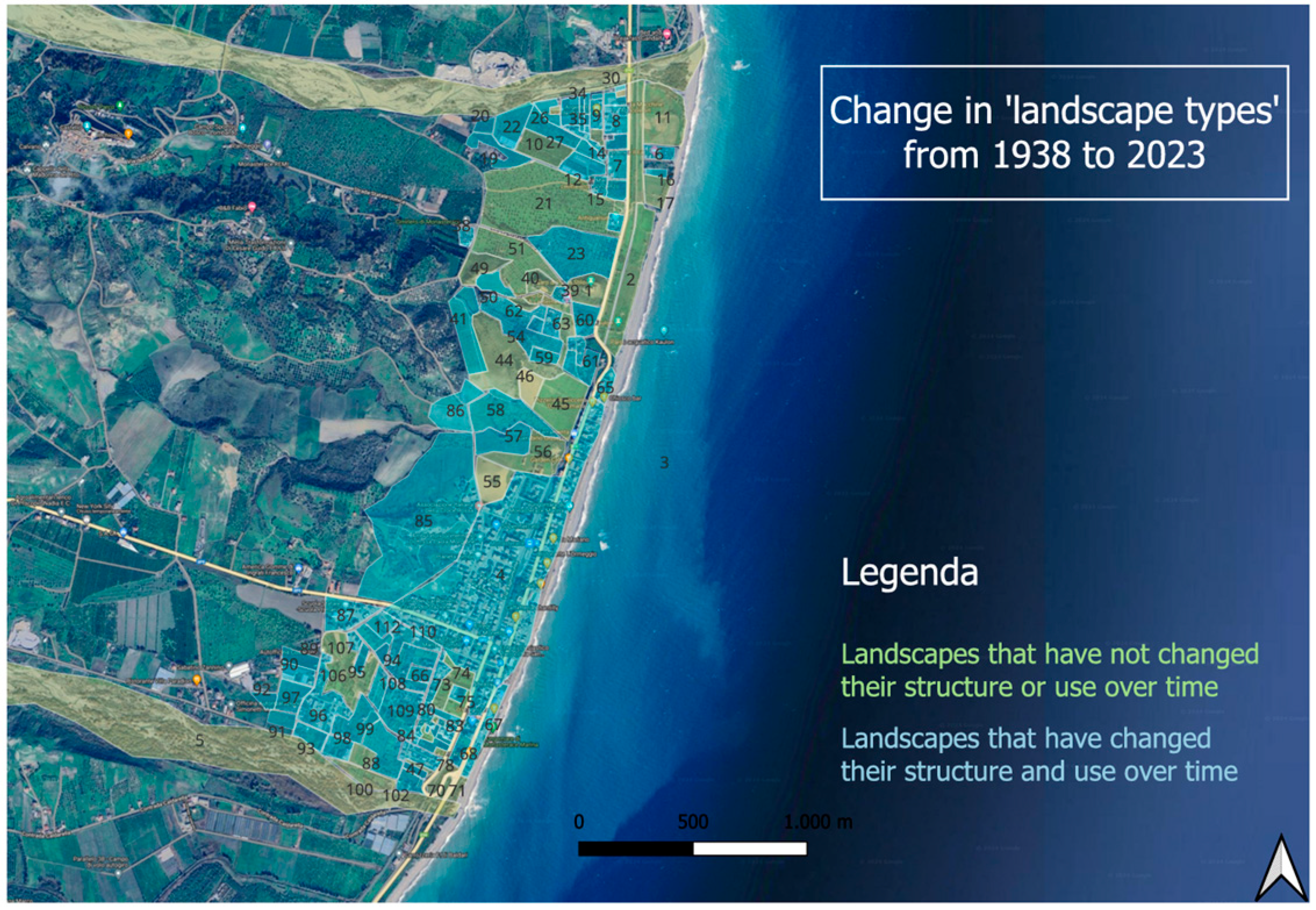
For the area under consideration, which lies between two torrents, the historical cartographies clearly showed the signs of the soil and crops related to the centurial grid, as well as the boundaries of the territory and the landscape arrangements replaced by the most recent reorganisation of the territory. With regard to the areas that have been transformed over time, it is possible to note that in the vicinity of the archaeological area, many large areas have remained with the same uses as in 1938, and only some of the information incorporated in the landscape has been altered: the areas that have changed their use are subdivided into small and multiple portions of areas that follow the morphology of the territory and the subdivision of land ownership (Figure 5).

Figure 5.
Map of landscape change with variation of landscape types in the period 1938–2024 of the archaeological area of Caulonia. The areas shaded in blue are the landscape types that have changed over the time period in question, changing their landscape structure and use. The areas shaded in green are landscape types that have not changed over the time period in question, while retaining the same function. Author’s elaboration using an HLC database in GIS (with QGis software, version 3.28).
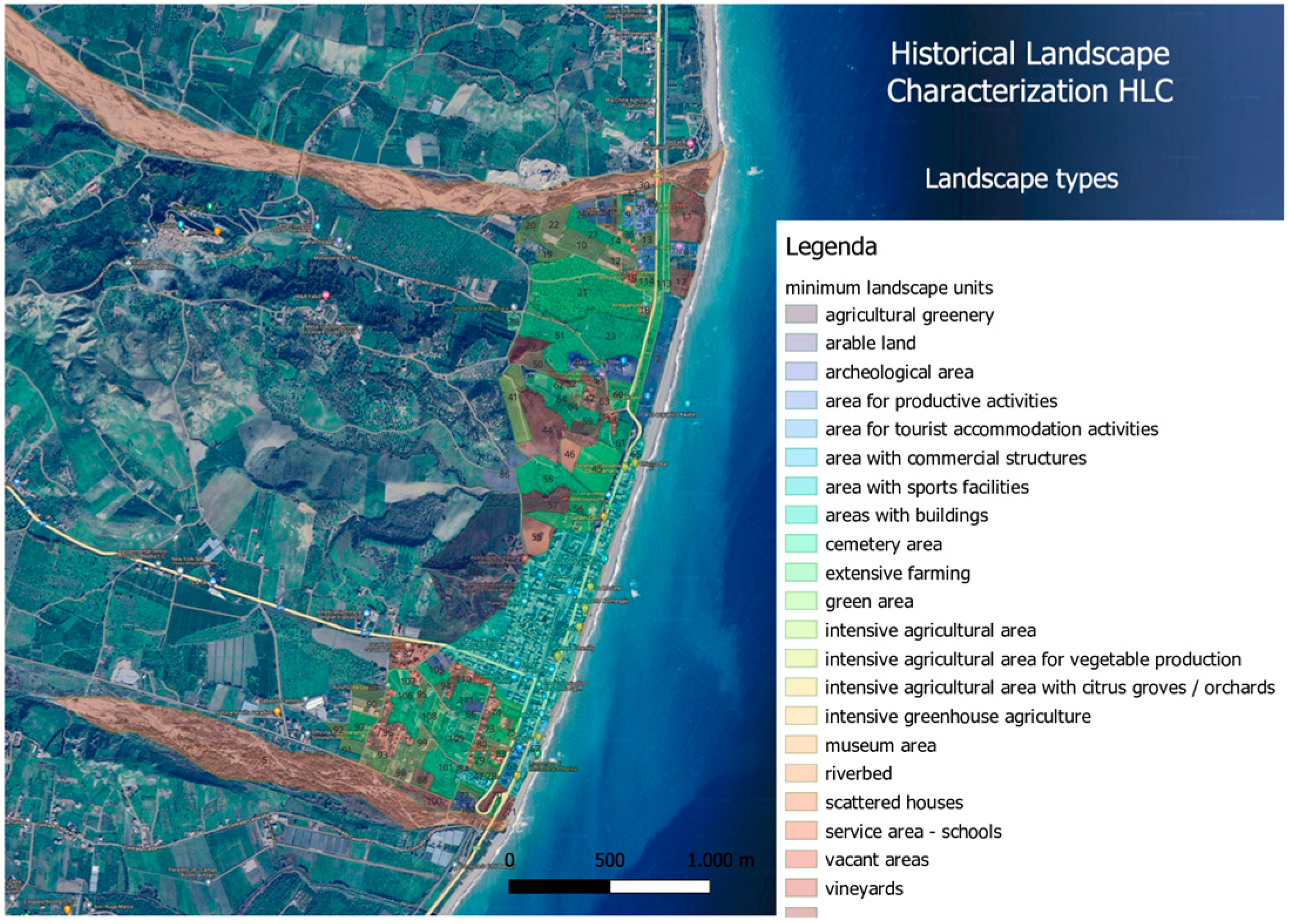
There are different ‘types’ of landscape, predominantly agricultural with intensive and extensive cultivation (citrus groves, orchards, vineyards, greenhouses for the production of vegetables), while closer to the coast the built-up area extends, and much of it is destined for the settlement of tourist facilities (Figure 6).

Figure 6.
Mapping the distribution of landscape types, whose character is strongly influenced by their use, and modelling the historical landscape of the archaeological area of Caulonia. The legend on the right of the map shows the landscape types as of 2024 and their mapping on the Google Earth satellite base. Author’s elaboration using an HLC database in GIS (with QGIS software, version 3.28).
The principle on which the use of photo areas and remote sensing data in archaeology is based is that every buried object, whether of human or natural origin, introduces anomalies into the characteristics of the overlying soil over time [25]. These anomalies are due to variations in the chemical–physical properties of the soil and the state of the vegetation cover. Specifically, some anomalies were found in the survey area [37].
In fact, the results that emerge from the processing, photolithography and photo interpretation of the orthophotos of 2000 and 2006, the historical aerial photographs of 1938 and 1958, and the MIVIS remote sensing data of 2011, represent a valid tool for the topographical study of the urban area, with the detection and identification of archaeological traces that could be pertinent to buildings, the road network, and the division of the insulae and fortifications. By comparing the edited data with the remotely sensed data, new questions emerge about the layout of the colony, its extension, and shape. Through the analysis of the data, it is possible to reconstruct the urban layout of the Roman town and the road network, and make hypotheses.
The first core of the Greek colony presumably covered the central belt, with a northern limit seemingly recognisable beyond the lighthouse hill. The city was organised in regular subdivisions of blocks with orthogonal street axes consisting of plateaus and stenopoi adhering to the conformation of the land, with a series of terraces progressively sloping towards the sea.
The urban layout of the Hellenistic city was conceived according to a regular ‘Hippodamian’ plan by strigas characterised by elongated blocks in an east–west direction, measuring 105 × 35 m. Only the part of the blocks located along the coast, due to the topography of the area, which had a smaller space due to the presence of the sea, are shorter, measuring 52.50 m on the longest side, for a length that is half that of the other blocks. All the blocks face main roads, parallel to the coastline, oriented in a north–south direction called plateiai, which intersect perpendicularly with minor road axes called stenopoi.
The main plateia is approximately 14 m wide and has been identified as the second from the coastline, located immediately behind the Doric temple, which must have constituted the urban section of the Ionian coastal road that connected Taranto to Reggio.
The blocks within them see a distribution of houses according to a square plan with a side of 17.5 m, which runs along the sides of a courtyard and faces a long, narrow rectangular room (the pastas) facing east. The arrangement of the houses seems to have been determined by the morphology of the terraced land sloping towards the sea. The entrance to the houses, for most of the excavated buildings, was on the north or south side. Two dwellings were arranged within a block, with the exception of a few cases (often public buildings) where houses occupying the entire insula are documented.
From the analysis of remote sensing images, carried out in 2011, it was possible to document traces that can be traced back to the Roman urban layout:
- In the land to the south of the urban layout, in the Carella locality, four linear stretches (stenopoi) are visible perpendicular to the main plateia that could be pertinent to the urban road system. The traces are light-coloured compared to the surrounding terrain, with an east–west direction. Three of the tracks measure a length of approximately 100 m when analysing the photolithography of the MIVIS images. In contrast, the northernmost track is recognisable on the remote sensing image for a length of approximately 300 m. In the same area, five distinct light-coloured linear traces, parallel to each other and parallel to the main plateia, were identified. The set of traces (plateiai and stenopoi) are pertinent to the urban organisation of the Greek city, consisting of a grid of streets that intersected at right angles and created the scamna layout of the ancient city [27].
- In the locality of Faro, in the centre of the city, six linear traces with a north–south orientation identifiable as stenopoi, perpendicular to the main plateia, have been identified. They are distinguished from the surrounding terrain by their colour and tone. All traces in these terrains are light-coloured and approximately 3 m long. In addition to the stenopoi, four distinct tracks parallel to the main plateia were identified. They may represent the continuation of the light-coloured tracks identified at the Carella locality. The plateiai are characterised by their light colour and different tonality to the surrounding terrain. The tracks are approximately 500 metres long [27].
- Between the locality of Faro and the walls surrounding the ancient centre along the north side, four long linear traces (stenopoi) were identified that are light-coloured in comparison to the surrounding terrain and perpendicular to the plateiai. The traces are approximately 400 m long; they are also visible in the terrain beyond the state road and beyond the railway line, near the beach [27].
Numerous traces have been identified within the archaeological area that, due to their type, shape and size, could be pertinent to the remains of structures of anthropogenic origin present in the former subsoil:
- The track (geolocalised with the coordinates 38°26′40.34″ N–16°34′25.50″ E.), which is darker in colour than the surrounding terrain, is quadrangular in shape, and delimits on the ground a structure with several rooms. It is located in the Carella locality, and appears on the photolithography and photointerpretation of the remote sensing images as a trace with a regular shape, consisting of a series of rooms that link together to create a structure that could be pertinent to a large building. The survey carried out in the area under examination did not yield any significant information, and to date it is not possible to define the origin of the track identified on the remote sensing images (Figure 7).
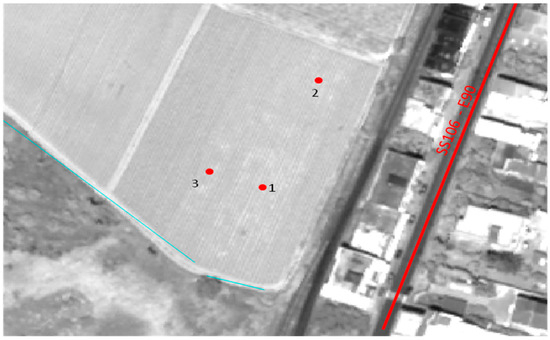 Figure 7. Localisation on the WordView 2 image of the various survey and photo interpretation sheets (n. 1-2-3), hypothesising the presence of remains of anthropogenic structures. Points 1-2-3 show the darker-coloured traces in relation to the surrounding terrain on the remote sensing images at Carella. Elaborated by the CNR-IIA research group involved in the Simona project.
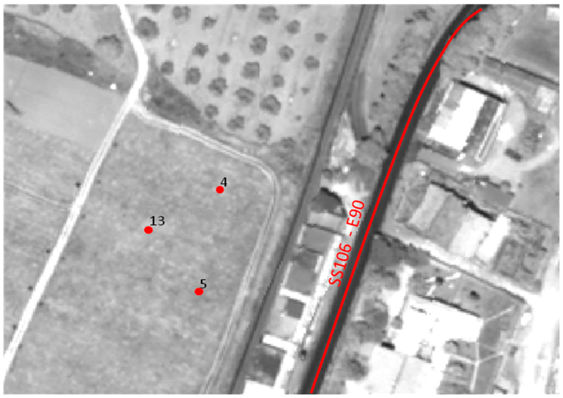
 - To the north–west of the urban settlement, a track (geolocalised with the coordinates 38°26′43.84″ N–16°34′22.91″ E.) was identified, which is light-coloured and quadrangular in shape. Due to its shape and size, the trace could be pertinent to a large building (Figure 8).
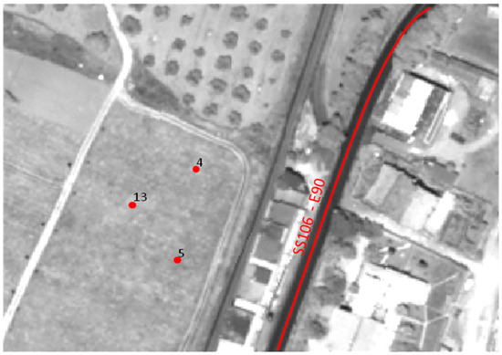 Figure 8. Localisation on the WordView 2 image of the various survey and photo interpretation sheets (n. 4-5-13), hypothesising the presence of remains of anthropogenic structures. Points 4-5-13 show the darker-coloured traces in relation to the surrounding terrain on the remote sensing images at the urban plant of Nord-Ovest. Elaborated by the CNR-IIA research group involved in the Simona project.
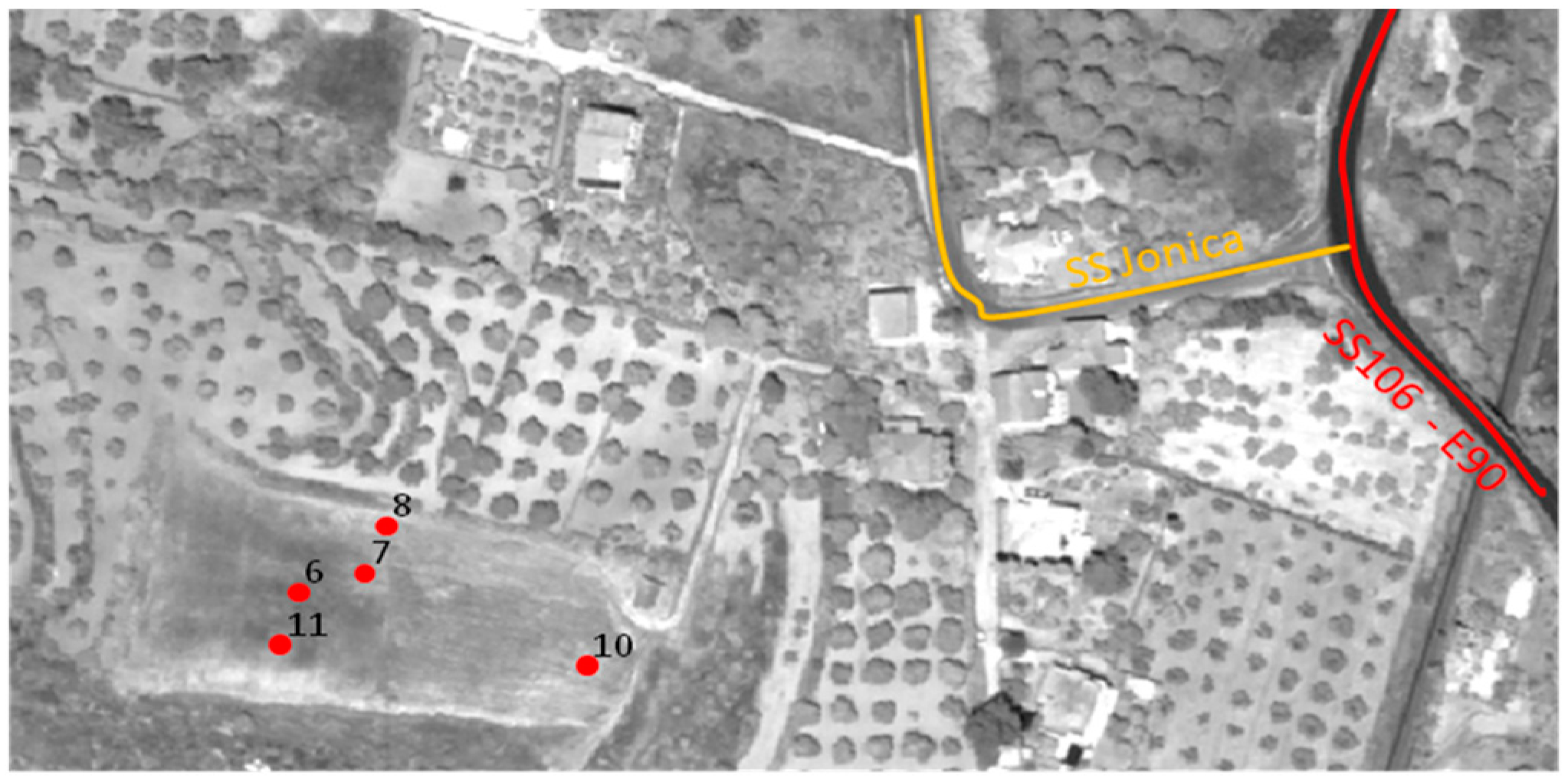
 - The reading and interpretation of the anomalies proved to be problematic: the area examined is characterised by the presence of a strong concentration of light-coloured material on the surface, possibly due to the destruction of the archaeological evidence by agricultural practices. In summary, a series of room-like structures arranged along a linear track (geolocalised with the coordinates 38°26′49.73″ N–16°34′28.11″ E.) could be identified (Figure 9 and Figure 10).
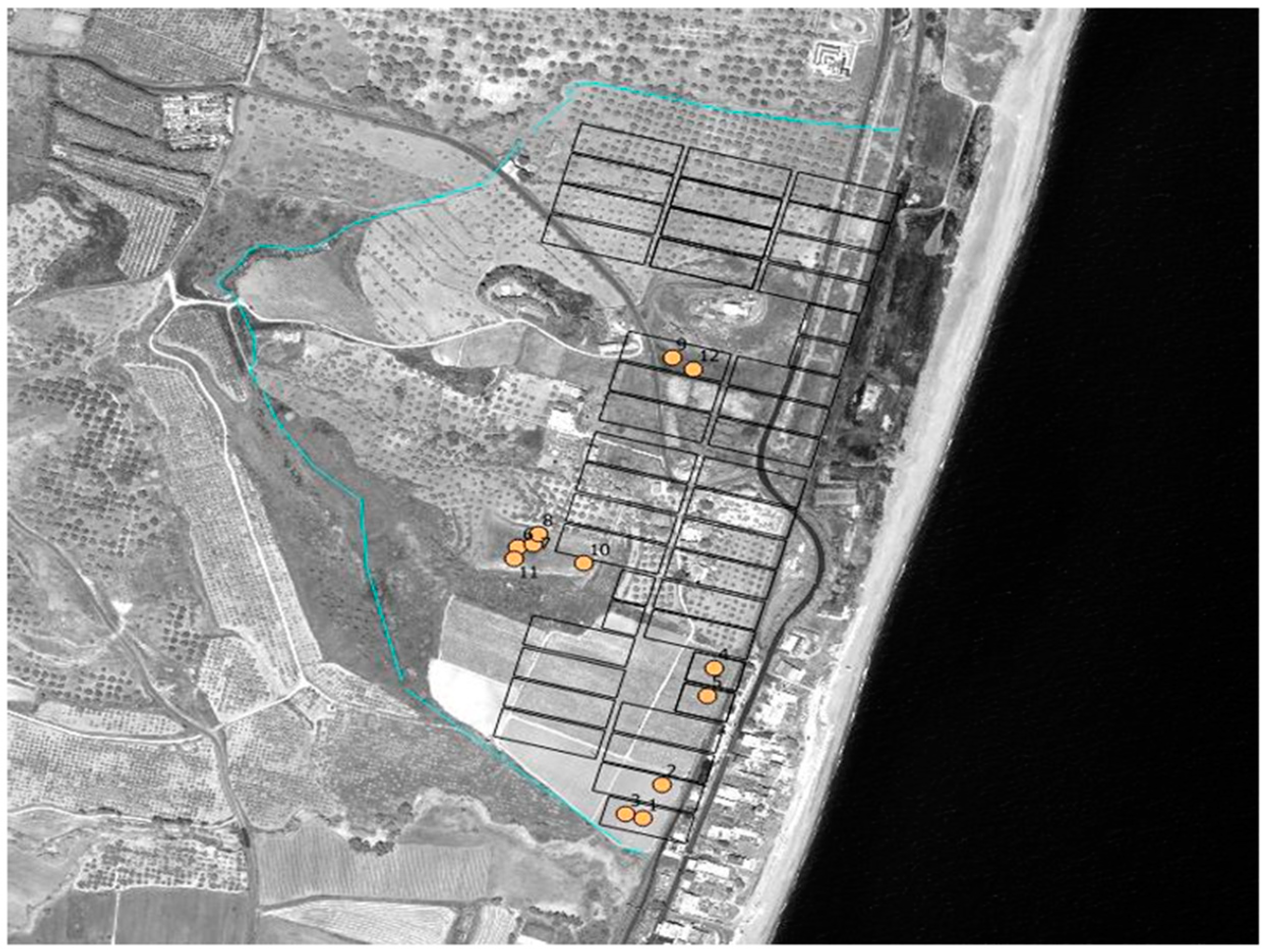
 Figure 9. Localisation on the WordView 2 image of the various survey and photo interpretation sheets (n. 6-7-8—10-11), hypothesising the presence of remains of anthropogenic structures. Points 6-7-8—10-11 show the darker-coloured traces in relation to the surrounding terrain on the remote sensing images. Elaborated by the CNR-IIA research group involved in the Simona project.
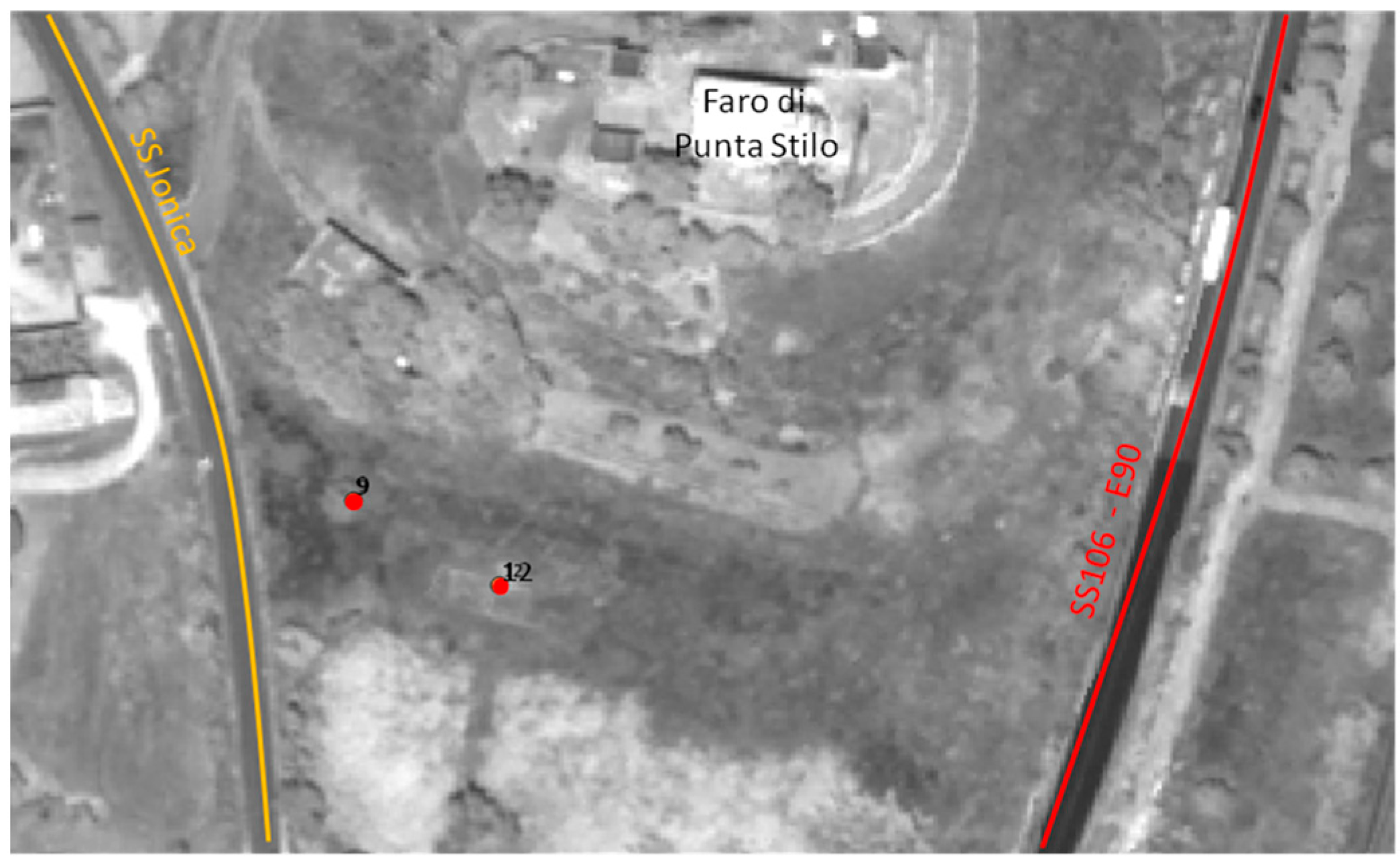
 Figure 10. Localisation on the WordView 2 image of the various survey and photo interpretation sheets (n. 9-12), hypothesising the presence of remains of anthropogenic structures. Points 9-12 show the darker-coloured traces in relation to the surrounding terrain on the remote sensing images at Punta Faro area. Elaborated by the CNR-IIA research group involved in the Simona project.
These observations offer new information that confirms the layout of the colony, its extent and shape.
Recent investigations along the coastline facing the archaeological site add new clues for the topographical reconstruction of the city.
The colony stood in a more inland position in the territory, with the coastline being at least 0.5/1 km away from the town. These data are confirmed by the presence of several structures from the Roman period found in the deep sea in front of the archaeological area. In particular, the presence of column rocks in the stretch of water in front of Punta Stilo, at a depth of approximately 20 m, is reported.
The discovery far from the current coastline confirms that the city in ancient times was located further from the coast and developed towards the sea at least for its port infrastructure. Even more complex is the identification of the southern perimeter of the city. The hypothesis of reconstructing an urban layout that respected the protected model on three sides, with the western side following the coastline, excluding from the urban area both the sandy shoreline, with possible port structures, and the necropolis, could be suggestive [27].
These proposals for reconstructing the urban layout of the ancient city were hypothesised on the basis of the topographical elements and the results obtained from the analysis of remote data and data acquired in situ.
Limits to interpretation have emerged in the study of the urban layout, due to both the limited archaeological and topographical knowledge and the state of abandonment of part of the archaeological area.
In the light of these considerations, the various traces identified at several points throughout the urban area were analysed (Figure 11).

Figure 11.
Reconstruction of the urban layout of the Roman centre of Caulonia with indication of the wall circuit, blocks and archaeological traces attributable to buried human structures. Author’s elaboration.
The case study of the archaeological area of Caulonia serves as a practical example, showing the applicability of the approach in real-life scenarios. It also successfully demonstrates how the integrated approach can reveal insights into the urban layout and historical evolution of the area, thus providing a sound basis for strategic planning and conservation efforts. The application of the methodology is replicable in other contexts. However, for a critical analysis of the limitations of the study, it must be pointed out that sometimes it is not possible to find historical cartography at significant dates useful for an effective comparison. Going back a long way in time, it is not possible to find aerial photogrammetry or aerial photos, but only prints or historical images, with which it is difficult to superimpose on the actual scale.
4. Conclusions
In this article I propose a method for integrating a remote sensing data airborne MIVIS sensor with historical landscape transformations surveyed through analytical HLC methodology, to identify both buried structures and possible risks of landscape and area loss archaeological areas, in order to formulate correct planning hypotheses for both territorial and constraining planning.
The experimental approach tested on the archaeological area of Caulonia was made possible by using accessible and free data, and GIS modelling and remote sensing analysis, which was carefully field-tested and compared with historical sources.
The analysis of the historical evolution of the landscape of the archaeological area of Caulonia can be used for the planning, design, and management of landscapes in relation to the conservation and protection of the archaeological area and risk prevention, because it provides all the information necessary for the identification of significant historical reference thresholds, as well as the identification of natural (geomorphological, vegetation, etc.) and anthropic (socio-economic urban, agricultural) thresholds that have occurred and are occurring, in order to guide the projects and plans of the local administrations.
The analysis carried out through the interpretation of MIVIS remote sensing images made it possible to document traces of the urban layout of the ancient city of Caulon and advance historical reconstruction hypotheses.
This approach can offer a powerful and inexpensive method to explore vast areas for the conservation of the cultural heritage of archaeological areas and for the reconstruction of the history of ancient settlements, as well as for implementing appropriate preventive strategies for risk assessment and planning and land management.
The study on Caulonia effectively illustrates how the integrated approach can monitor and interpret changes in land use and landscape over historical periods. It demonstrates the methodology’s potential to identify landscape risk elements and inform future landscape transformations, and provides practical implications for heritage conservation in the face of contemporary development challenges.
Funding
This research activity was funded by the National Research Council through the CNR/RS bilateral project (B23C23000740002).
Data Availability Statement
The author confirm that the data supporting the findings of this study are available within the article.
Acknowledgments
This publication was been realised thanks to funding under the bilateral agreement CNR/Royal Society, project name: “Combining remote sensing technologies and historic landscape characterisation to manage archeological heritage assets at risk: two pilot studies in Italy and the United Kingdom”, two-year period 2023–2024.
Conflicts of Interest
The author declare no conflict of interest.
References
- McNab, A.; Lambrick, G. Conclusions and recommendations. In Yesterday’s World, Tomorrow’s Landscape: The English Heritage Landscape Project 1992–1994; Fairclough, G., Lambrick, G., McNab, A., Eds.; English Heritage: London, UK, 1999; pp. 54–59. [Google Scholar]
- Swanwick, C.; Fairclough, G. Landscape character: Experience from Britain. In Routledge Handbook of Landscape Character Assessment: Current Approaches to Characterisation and Assessment; Fairclough, G.G., Sarlöv Herlin, I., Swanwick, C., Eds.; Routledge: London, UK, 2018; pp. 21–35. [Google Scholar]
- CofE. European Landscape Convention; European Treaty Series: Florence, Italy, 2000; N. 176; Available online: http://conventions.coe.int/Treaty/en/Treaties/Html/176.htm (accessed on 16 September 2023).
- Turner, S. Historic landscape characterisation: A landscape archaeology for research, management and planning. Landsc. Res. 2006, 31, 385–398. [Google Scholar] [CrossRef]
- Swanwick, C.; LUC. Landscape Character Assessment: Guidance for England and Scotland, Cheltenham and Edinburgh; Countryside Agency and Scottish Natural Heritage; 2002; Available online: https://digital.nls.uk/pubs/e-monographs/2020/216649977.23.pdf (accessed on 1 March 2024).
- Fairclough, G.J. Steps towards the integrated management of a changing landscape: Historic Landscape Characterisation in England. In Cultural Heritage on the Urban Fringe, Nannetsad Workshop Report, March 2002; NIKU 126; Swensen, G., Ed.; Norsk Institut for Kulturminneforskning: Oslo, Norway, 2002; pp. 29–39. [Google Scholar]
- Turner, S. Making a Christian Landscape; University of Exeter Press: Exeter, UK, 2006. [Google Scholar]
- Fairclough, G.J. The long chain: Archaeology, historical landscape characterization and time depth in the landscape. In Landscape Interfaces: Cultural Heritage in Changing Landscapes; Palang, H., Fry, G., Eds.; Kluwer: Dordrecht, The Netherlands, 2003; pp. 295–318. [Google Scholar]
- Gumerman, G.J.; Lione, T.R. Metodologia archeologica e telerilevamento. Science 1971, 72, 126–132. [Google Scholar] [CrossRef] [PubMed]
- Marcolongo, B. Natural resources and palaeoenvironment in the Tadrart Acacus: The non climatic factors determining human occupation. In Archaeology and Environment in the Libyan Sahara; The Excavations in the Tadrart Acacus 1978–1983; Barich, B.E., Ed.; BAR International Series: Oxford, UK, 1987; pp. 282–289. [Google Scholar]
- Marcolongo, B.; Barisano, E. Télédétection et archéologie: Concepts fondamentaux, état de l’art et exemples. In Non Destructive Techniques Applied to Landscapes Archaelogy, “the Archaelogy of Mediterranean Landscape”; Pasquinucci, M., Trément, F., Eds.; CNRS Editions; Oxford, UK, 1999; pp. 5–30. Available online: https://www.amazon.fr/Teledetection-arch%C3%A9ologie-Collectif/dp/2222032644 (accessed on 1 March 2024).
- Cavalli, R.M.; Pignatti, S. Il telerilevamento iperspettrale da aereo per lo studio dei Beni Archeologici: Applicazione dei dati iperspettrali MIVIS. In Remote Sensing in Archaeology, XI Ciclo di Lezioni sul la Ricerca Applicata in Archeologia; Campana, S., Forte, M., Eds.; Certosa di Pontignano: Firenze, Italy, 2001; pp. 22–232. [Google Scholar]
- Traviglia, A. Integration of MIVIS Hyperspectral remotely sensed data and Geogrphical Information System to study ancient landscape: The Aquileia case study. Agri Centuriati 2005, 2, 139–170. [Google Scholar]
- Lasaponara, R.; Masini, N. Rilevamento di segni di colture archeologiche utilizzando immagini multispettrali satellitari QuickBird. J. Archaeol. Sci. 2007, 34, 214–221. [Google Scholar] [CrossRef]
- Agapiou, A.; Lysandrou, V.; Sarris, A.; Papadopuolos, N.; Hadjimitsis, D.G. Fusione di immagini satellitari multispettrali basate su dati radar a penetrazione del suolo (GPR) per l‘indagine di resti archeologici nascosti sepolti. Geoscienze 2017, 7, 40. [Google Scholar] [CrossRef]
- Cerra, D.; Plank, S.; Lysandrou, V.; Tian, J. Siti del patrimonio culturale in pericolo: Verso il rilevamento automatico dei danni dallo spazio. Telerilevamento 2016, 8, 781. [Google Scholar]
- Anthony, E.J.; Marriner, N.; Morhange, C. Human influence and the changing geomorphology of Mediterranean deltas and coasts over the last 6000 years: From progradation to destruction phase. Earth-Sci. Rev. 2014, 139, 336–361. [Google Scholar] [CrossRef]
- Butzer, K.W. Geoarcheologia, cambiamenti climatici, sostenibilità: Una prospettiva mediterranea. Geol. Soc. Am. Spec. Pap. 2011, 476, 1–14. [Google Scholar]
- Bini, M.; Pappalardo, M.; Rossi, V.; Noti, V.; Amorosi, A.; Sarti, G. Deciphering the effects of human activity on urban areas through morphostratigraphic analysis: The case of Pisa, Northwest Italy. Geaoarcheologia 2017, 33, 43–51. [Google Scholar] [CrossRef]
- Casana, J. Valli mediterranee rivisitate: Collegamento tra erosione del suolo, uso del suolo e variabilità climatica nel Levante settentrionale. Geomorfologia 2008, 101, 429–442. [Google Scholar]
- Kvamme, K.L. Geographic information systems in regional archaeological research and data mana gement. In Archaeological Method and Theory; Schiffer, M.B., Ed.; JSTOR: Tucson, Arizona, 1989; pp. 39–203. [Google Scholar]
- Campana, S.; Forte, M. (Eds.) Remote Sensing in Archaeology, XI Ciclo di Lezioni sul la Ricerca Applicata in Archeologia; All’Insegna del Giglio: Certosa di Pontignano, Firenze, 2001. [Google Scholar]
- Dabaut, N.; Carrer, F. Historic Landscape Characterisation: Technical Approaches Beyond Theory. Landscapes 2020, 21, 152–167. [Google Scholar] [CrossRef]
- Brandolini, F.; Kinnaird, T.C.; Srivastava, A.; Turner, S. Modelling the impact of historic landscape change on soil erosion and degradation. Sci. Rep. 2023, 13, 4949. [Google Scholar] [CrossRef] [PubMed]
- Cavalli, R.M.; Merola, P.; Pignatti, S.; Poscolieri, M. Telerilevamento iperspettrale MIVIS per lo studio delle testimonianze antropiche nell’area archeologica di Arpi (FG). Riv. Ital. Di Telerilevamento 2005, 34, 109–117. [Google Scholar]
- Hadjimitsis, D.G.; Themistocleous, K.; Cuca, B.; Agapiou, A.; Lysandrou, V.; Lasaponara, R.; Masini, N.; Schreier, G. (Eds.) Remote Sensing for Archaeology and Cultural Landscapes Best Practices and Perspectives Across Europe and the Middle East; Springer: Berlin/Heidelberg, Germany, 2020. [Google Scholar]
- Allegrini, A.; Merola, P.; Fontinovo, G.; Quattrone, G.; Salvatori, R.; Institute of Atmospheric Pollution, National Research Council, Rome, Italy. Sviluppo di Tecniche Innovative di Telerilevamento per il Rilievo di Beni Culturali Nell’entroterra e in Ambiente Costiero; Final technical report of Simona Project; Institute of Atmospheric Pollution, National Research Council: Rome, Italy, 2017; Internal report. [Google Scholar]
- Scuteri, A. Kaulon-Castelvetere Caulonia; Calabria Letteraria Editrice: Soveria Mannelli, Italy, 2008. [Google Scholar]
- Smpolo, C. Kaulonía, Caulonia, Stilida (e oltre), IV. Il Santuario di Punta Stilo. Studi e Ricerche; Scuola Normale Superiore Editore: Pisa, Italy, 2017. [Google Scholar]
- Lepore, L.; Luberto, M.A.; Turi, P. Kaulonia, la Città Dell’amazzone Clete. Gli Scavi dell’Università degli Studi di Firenze a Monasterace Marina; Catalogo della Mostra; Firenze-Museo Archeologico Nazionale: Firenze, Italy, 2013. [Google Scholar]
- Barello, F. Architettura Greca a Caulonia. Edilizia Monumentale e Decorazione Architettonica in una Città Della Magna Grecia; Le Lettere Editore: Firenze, Italy, 2013. [Google Scholar]
- Lepore, L.; Turi, P. (Eds.) Caulonia tra Crotone e Locri. In Proceedings of the International Congress, Firenze, Italy, 30 May–1 June 2007; Firenze, Italy, 2010. [Google Scholar]
- Guzzo, P.G. Le Città Scomparse Della Magna Grecia; Newton Compton: Roma, Italy, 1982. [Google Scholar]
- Parra, M.C. (Ed.) Kaulonía, Caulonia, Stilida (E Oltre). Contributi Storici, Archeologici e Topografici; Quaderni ASNP: Pisa, Italy, 2002; Volumes I–II. [Google Scholar]
- Parra, M.C.; Facella, A. (Eds.) Kaulonía, Caulonia, Stilida (e Oltre); Indagini Topografiche nel Territorio; Scuola Normale Superiore Editore: Pisa, Italy, 2011; Volume III. [Google Scholar]
- Luberto, M.R. Aree sacre e quartieri artigianali in Magna Grecia: Le colonie achee. In Travailler à L’ombre du Temple-Activités de Production et Lieux de Culte dans le Monde Antique; De Cazanove, O., Esposito, A., Monteix, N., Pollini, A., Eds.; Publications du Centre Jean Bérard, Collection du Centre Jean Bérard: Naples, Italy, 2023; pp. 173–195. [Google Scholar]
- Alla Gad, A.; Elfiky, D.; Negm, A.; Elbeih, S. (Eds.) Applications of Remote Sensing and GIS Based on an Innovative Vision. In Proceedings of the First International Conference of Remote Sensing and Space Sciences Applications, Hurgada, Egypt, 8–11 December 2022; Springer Proceedings in Earth and Environmental Sciences. Springer Nature: Cham, Switzerland, 2023. [Google Scholar]


Disclaimer/Publisher’s Note: The statements, opinions and data contained in all publications are solely those of the individual author(s) and contributor(s) and not of MDPI and/or the editor(s). MDPI and/or the editor(s) disclaim responsibility for any injury to people or property resulting from any ideas, methods, instructions or products referred to in the content. |
© 2024 by the author. Licensee MDPI, Basel, Switzerland. This article is an open access article distributed under the terms and conditions of the Creative Commons Attribution (CC BY) license (https://creativecommons.org/licenses/by/4.0/).