Review

Submarine Instability Processes on the Continental Slope Offshore of Campania (Southern Italy)

by
Gemma Aiello
Istituto di Scienze Marine (ISMAR), Consiglio Nazionale delle Ricerche (CNR), Sezione Secondaria di Napoli, 80133 Napoli, Italy
GeoHazards 2025, 6(2), 20; https://doi.org/10.3390/geohazards6020020
Submission received: 19 March 2025 / Revised: 13 April 2025 / Accepted: 22 April 2025 / Published: 24 April 2025

Abstract

:
A revision of the submarine instability processes offshore the Campania region is presented herein based on the literature data and Multibeam bathymetric and seismic profiles previously acquired by the CNR ISMAR of Naples (Italy). Among others, the objectives and perspectives of this research include the following: the chrono-stratigraphic framework of the submarine instability events and their correlation with the trigger geological processes, including the seismicity, the volcanism and the tectonic activity; density reversal has not been detected as a control factor; the implementation of technologies and database for the acquisition and the processing of morpho-bathymetric, seismo-stratigraphic and sedimentological data in the submarine slopes of Campania, characterized by submarine gravitational instabilities. Other main tasks include producing thematic geomorphological maps of the submarine slopes associated with instability phenomena. The principles of slope stability have been revised to be independent of the slope height. In submarine slopes mainly composed of sand, the stability depends on the slope inclination angle concerning the horizontal (β), equal or minor to the internal friction angle of loose sand (ϕ). Based on this research, it can be outlined that the submarine instability processes offshore of Campania mainly occur along the flanks of volcanic edifices, both emerged (Ischia) and submerged (Pentapalummo, Nisida, Miseno, Procida Channel), on steep, tectonically-controlled sedimentary slopes, (southern slope of Sorrento Peninsula, slope of the Policastro Gulf), and on ramps with a low gradient that surround wide continental shelves (Gulf of Salerno).

1. Introduction

The submarine instability processes offshore of the Campania region have been the subject of a former study focused on Ischia Island [1]. The geological interpretation of the marine DEM (Digital Elevation Model) of Ischia Island has revealed an articulated topography of the sea bottom and a complex stratigraphic architecture with interconnections. The submerged sectors of Ischia Island are the site of submarine gravity instability processes, which have both catastrophic (instantaneous) and continuous characteristics [1]. Previously, Milia et al. [2] have studied the submarine gravitational instabilities of the submarine volcanoes located offshore the Campi Flegrei volcanic complex [3,4,5]. Four categories of volcanic slopes were identified, including the steep slopes with low-relief morphological characteristics resulting from shallow translational slump complexes, the steep slopes with high-relief morphological features linked to deep rotational slump complexes, the steep slopes characterized by scars and slump deposits at the base on a nearly flat surface; and finally, slopes with a staircase morphology associated with shallow rotational slumps.
The coastal areas of the Bay of Naples are distinguished from the Naples canyons [6,7]. Morpho-bathymetric and sedimentological data from sea-bottom samples have been merged to reconstruct the geological evolution of the Naples canyons during the Late Quaternary. Moreover, potential waves and run-up (tsunami) reconstructions have also been evaluated for a fossil submarine landslide of Naples Bay [8]. More recently, detailed DEMs of Naples Bay have been constructed by integrating different bathymetric datasets [9], showing the morphological complexity of the Naples Bay area.
This paper aims to revise the submarine instability processes offshore the Campania region and highlight possible perspectives and objectives in the study of the region. To reach this task, a large database recorded by the CNR-ISMAR of Naples (Italy) was used, including morpho-bathymetric and seismic data recorded in several sectors of the Campania–Latium continental margin [10].
A landslide or slippage of a slope consists of the displacement downwards or outwards of a significant mass of soil. The classical Varnes classification of landslides has distinguished numerous types of landslides [11]. This classification has been revised by Hungr et al. [12], who have produced the modified Varnes classification of landslides, distinguishing 32 landslide types, each backed by a formal definition. Landslides occur in all sorts of ways, slowly or suddenly, with or without an obvious cause. In general, they are caused by excavation or cutting of the foot of the slope, but sometimes also by a gradual disintegration of the soil structure, which begins with the formation of hairline cracks, by the increase in interstitial pressure that occurs in particularly impermeable layers or by an impact that causes the liquefaction of the soil [13]. This soil mechanic also applies to coastal and submarine landslides [14].
Several objectives and perspectives have been individualized in this research. They include:
-
Geological analysis of the instability phenomena in the Campania submarine slopes at several scales. In particular, the slow submarine instabilities (creeping, slumping, deep-seated gravitational deformation) are distinguished from the fast submarine instabilities (debris avalanches, rock falls, roto-translational slides) offshore of Campania with marine geological methods (morpho-bathymetry, high-resolution seismic profiles, Sidescan Sonar sonograms, sea bottom samples).
-
A chrono-stratigraphic framework of the events of submarine instability and their correlation with the trigger geological processes, including seismicity, volcanism and tectonic activity.
-
Implementation of technology and database for acquiring and processing morpho-bathymetric, seismo-stratigraphic, and sedimentological data in the submarine slopes characterized by gravitational instability.
-
Analysis of the geological factors triggering the submarine instabilities in the slope areas, including the following: increase in steepness of the topographic profile of the slope following high sedimentary supply and consequent exceeding of the critical stability angle of the submarine slope; increase in water content on sediment slopes and triggering of slumping and creeping phenomena on high and medium slope slopes. Other trigger factors are represented by the emersion/erosion phenomena and subsequent flooding in correspondence with glacio-eustatic oscillations of the sea level during the Upper Quaternary, by the presence of discontinuity surfaces within the stratigraphic record that represents potential sliding planes, by the presence of gas hydrate pockets within the stratigraphic succession [15], and finally, by the tectonic activity in correspondence with regional direct or strike–slip faults [16]. The strata density reversal represents another possible cause. When a dense layer lies on top of a weaker layer, then the collapse should occur. Biscontin and Pestana [17] have discussed the importance of several factors controlling the response of submarine slopes during seismic loading. A dynamic finite element code has been used, including a law based on the anisotropic stress–strain–strength behavior of normally consolidated to lightly over-consolidated clays. Parametric site response analyses on slope geometry and layering, soil material parameters, and input ground motion characteristics have been shown [17]. During a seismic event, the slope performance is controlled by several factors, including the predicted maximum shear strains, the permanent deformations, the displacement time histories and the maximum excess pore pressure.
Important physical characteristics, including the water content, the porosity, the wet bulk density, and the grain density, have been analyzed on several continental margins of the world, giving information in well logs, which have shown abrupt peaks in specific depth intervals, suggesting sudden facies changes and changing depositional environments [18,19]. On the Norwegian continental margin, the density reversal contributed to the evacuation of sediments on the continental slope, controlling the formation of evacuation surfaces in the Storegga Slide [19]. The long-term slope instability was controlled by the presence of multiple weak layers. Also, if observed on other continental margins, the strata density reversal has not been directly observed on the Campania continental margin, and corresponding submarine instabilities have not been detected [19].
A brief review of recent research progress is discussed in the frame of the Italian National Project MaGIC (Marine Geohazards along the Italian Coasts) [20,21]. Chiocci et al. [20] have shown the general framework of this research project and the research progress on marine geohazards due to the increasing technological content of Multibeam bathymetric studies. Budillon et al. [21] have reported on the thematic maps developed offshore the Latium–Campania region within the general framework of this project, based on the geomorphological analysis of the DEM of the seafloor. Several classes of morpho-structural elements, mainly related to marine hazards, have been identified, genetically related to high-gradient slopes, volcanic activity, and morpho-dynamic processes. The discussion of all the scientific contributions published in the frame of the MaGIC Project, dealing with all the Italian Seas, is not a task of this paper, concentrating only on the submarine instabilities and the marine geohazards in the Campania offshore.

2. Materials and Methods

The materials and methods include the revision of the literature data existing on the topic and the geological interpretation of morpho-bathymetric, sedimentological and seismo-stratigraphic data recorded by the CNR ISMAR of Naples (Italy) during numerous oceanographic cruises, starting from 1998. Seismo-stratigraphic techniques and methods have been applied in the geological interpretation of seismic profiles [22,23,24]. Seismic stratigraphy is an analytical methodology that allows for the identification of depositional sequences and related unconformities based on the identification of lateral terminations.
Previously, the field geological survey, the measurement of stratigraphic sections, and the lithologic and paleontologic descriptions served as the foundation for stratigraphic analysis, which intended to reconstruct the depositional settings and correlate the stratigraphic sequences among them. The beginning of seismic stratigraphy has brought about a significant change in this work methodology, enabling the acquisition of comprehensive seismic records of the stratigraphic successions.
The fundamental idea behind the seismic stratigraphy approach is that the seismic reflectors can be compared to the strata plans and that their geometry may match the depositional geometry [22,23,24].
The seismo-stratigraphic analysis consists of three main steps, i.e., the identification of the regional unconformities and of the related depositional sequences, by the renewal of the initial geometry of the sedimentary bodies and related sedimentary environments and by the chrono-stratigraphic correlation [22,23,24].
Although it has evolved to denote submarine topography, or the depths and forms of underwater terrain, the term “bathymetry” originally referred to the ocean’s depth in relation to sea level. Bathymetric maps depict the land beneath the water, much like topographic maps depict the three-dimensional features (or relief) of overland terrain. Depth contours, also known as isobaths, are color and contour lines that show variations in seafloor relief. The science of hydrography, which measures a body of water’s physical characteristics, is based on bathymetry. Along with bathymetry, hydrography also takes into account the shoreline’s structure and features, the tides, currents, and waves, as well as the physical and chemical qualities of the water itself.
Morpho-bathymetric data and methodologies have deeply evolved with the development of new Multibeam techniques and have been successfully applied offshore in Campania. Starting from the basic papers of Aiello et al. [25] and D’Argenio et al. [26], several papers have shown up-to-date bathymetries of the Campania region: Somma et al. [27] for the Gulf of Pozzuoli, Passaro et al. [28] for the Bay of Naples and more recently Foglini et al. [29] for the Bay of Naples, through the integration of different bathymetric datasets, and Gianardi et al. [30] for the Campi Flegrei area, both onshore and offshore. Moreover, morpho-bathymetric maps of the marine hazard in Naples Bay have also been constructed [31].

3. Results

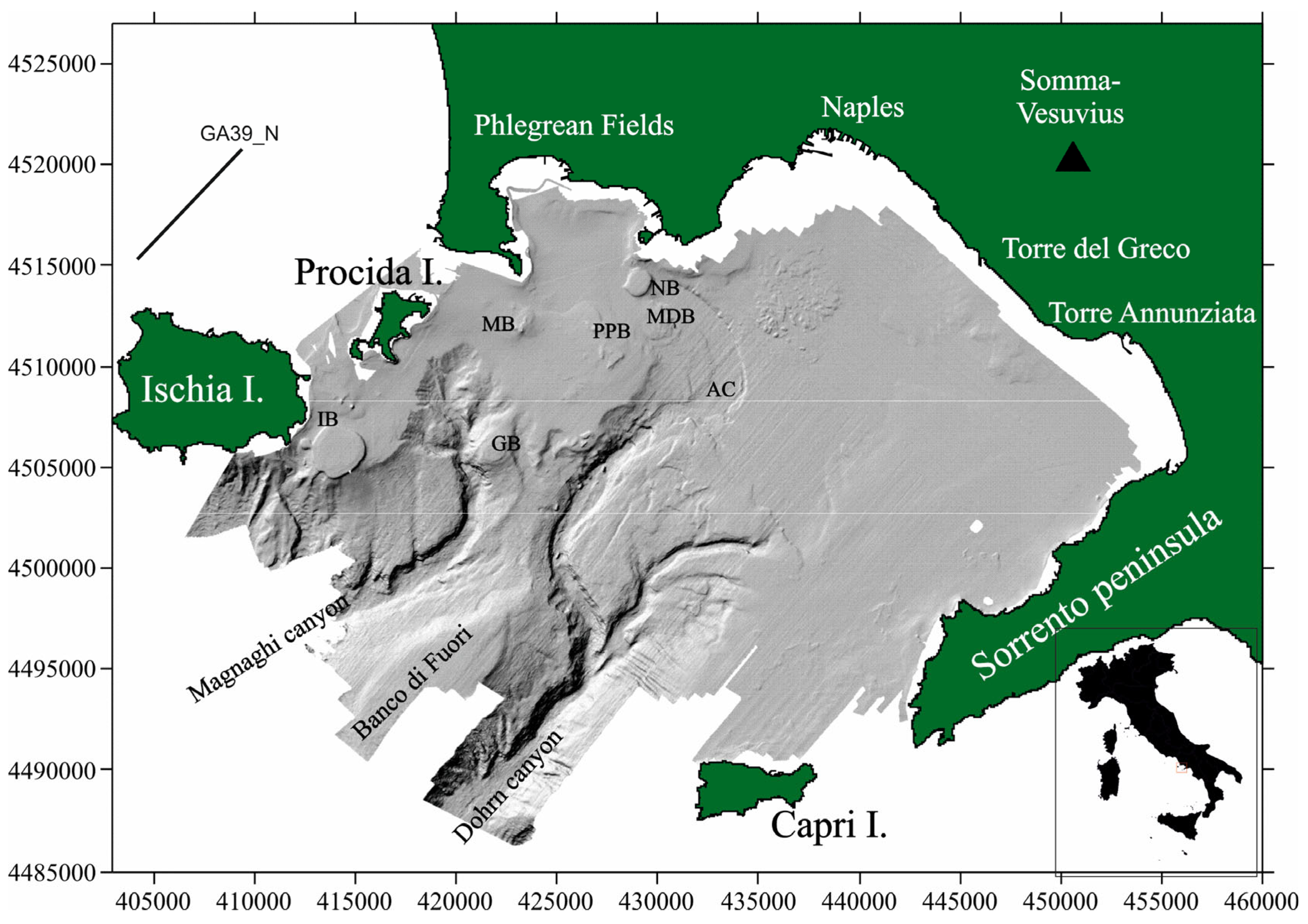
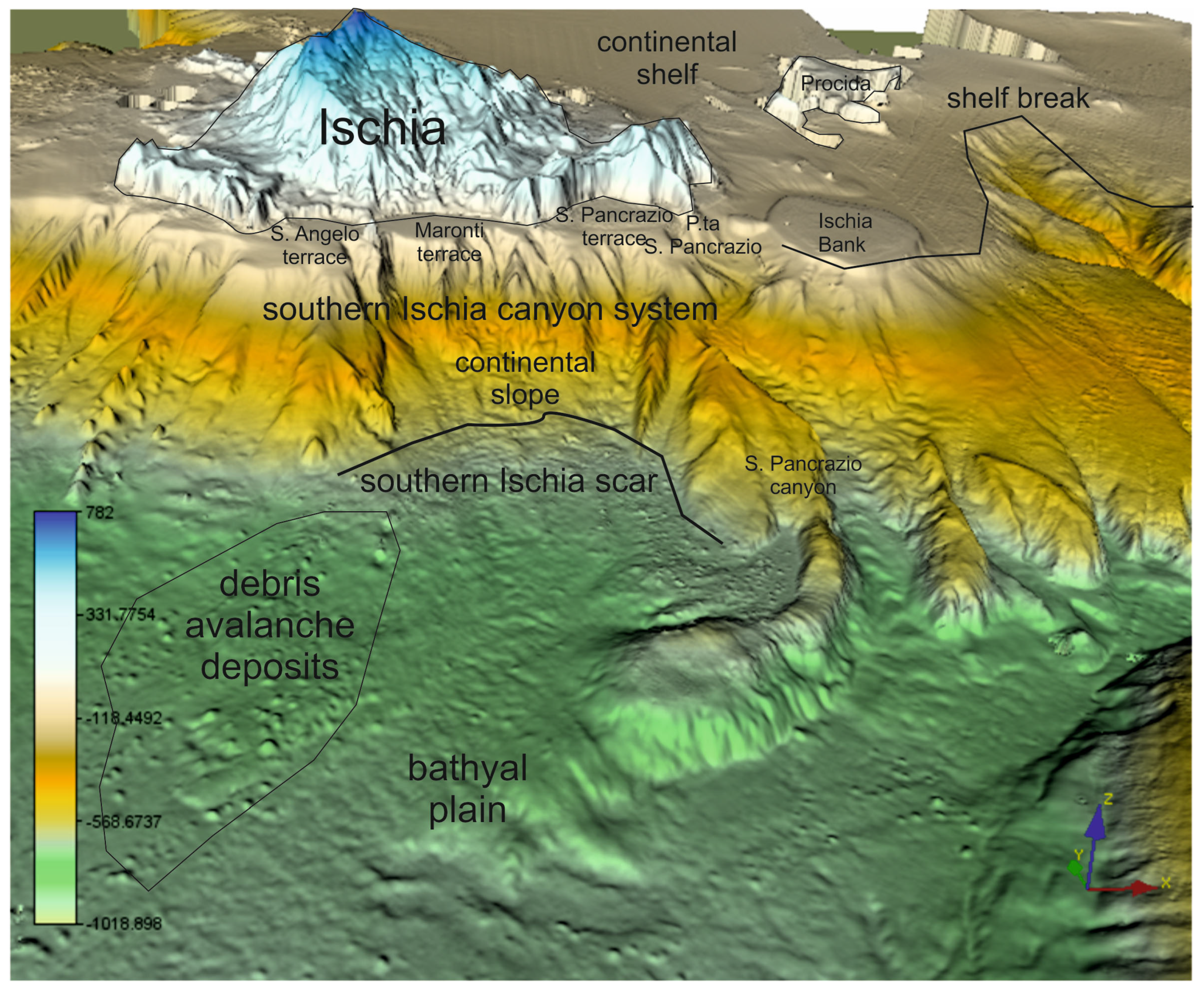
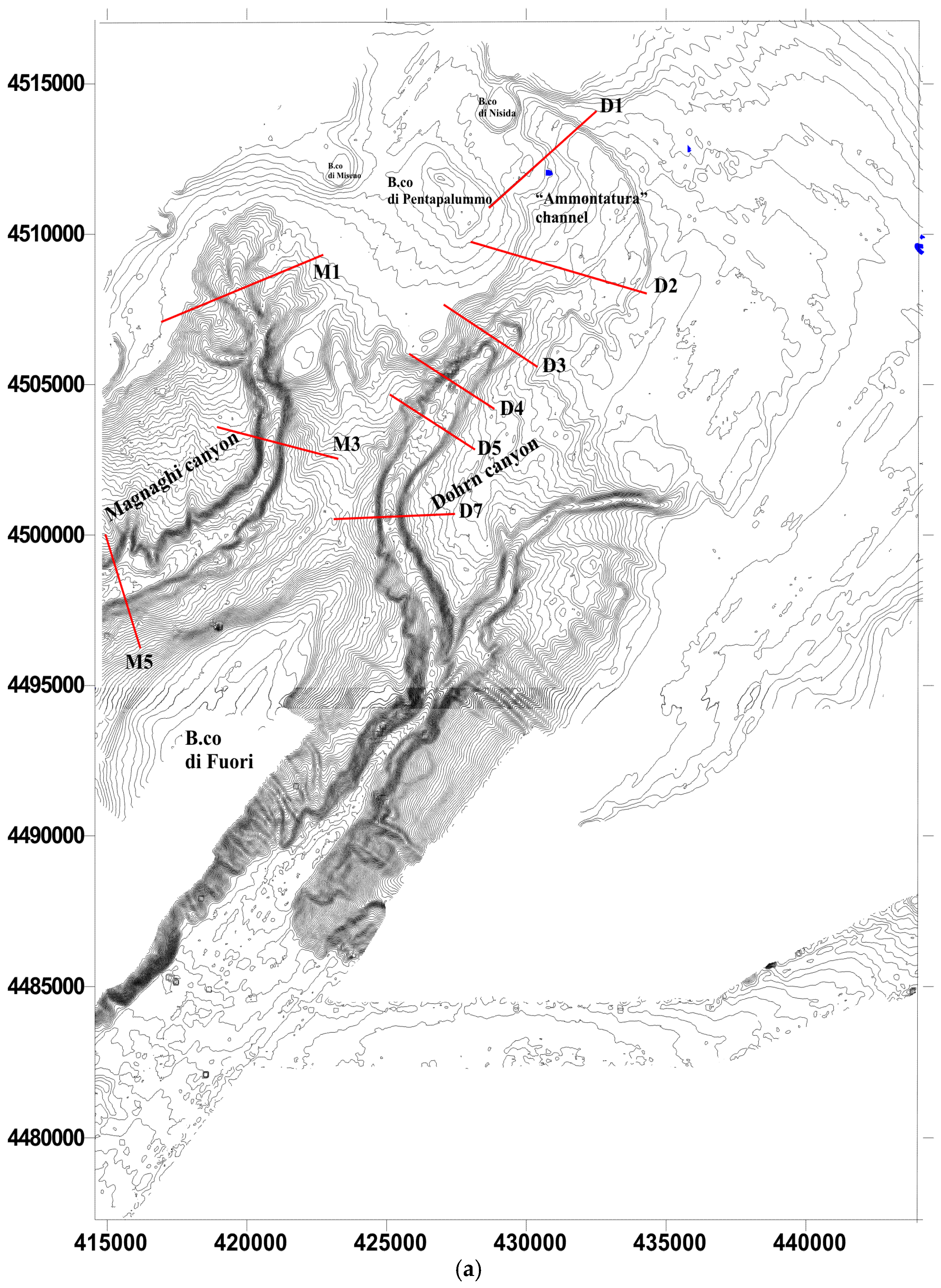
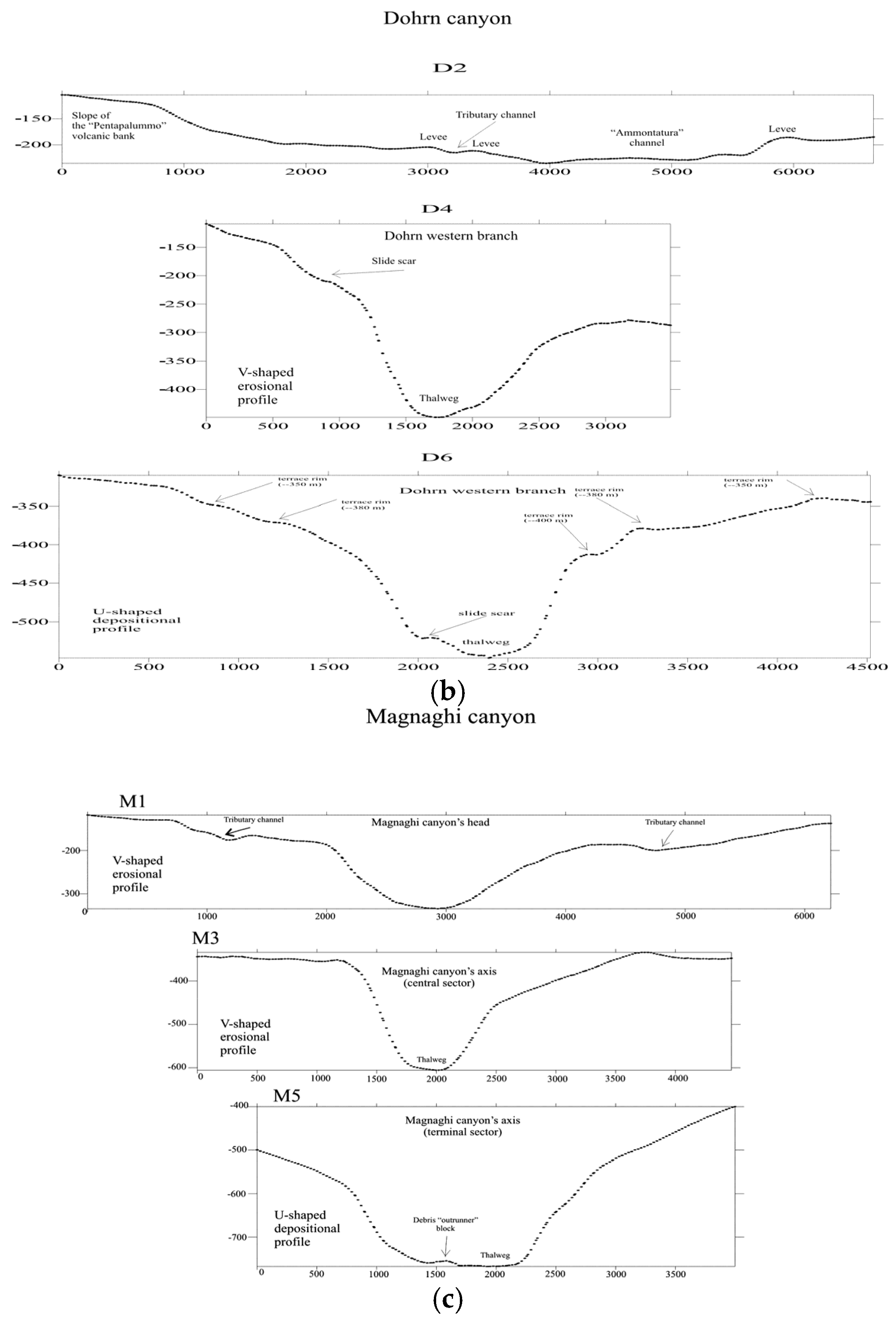
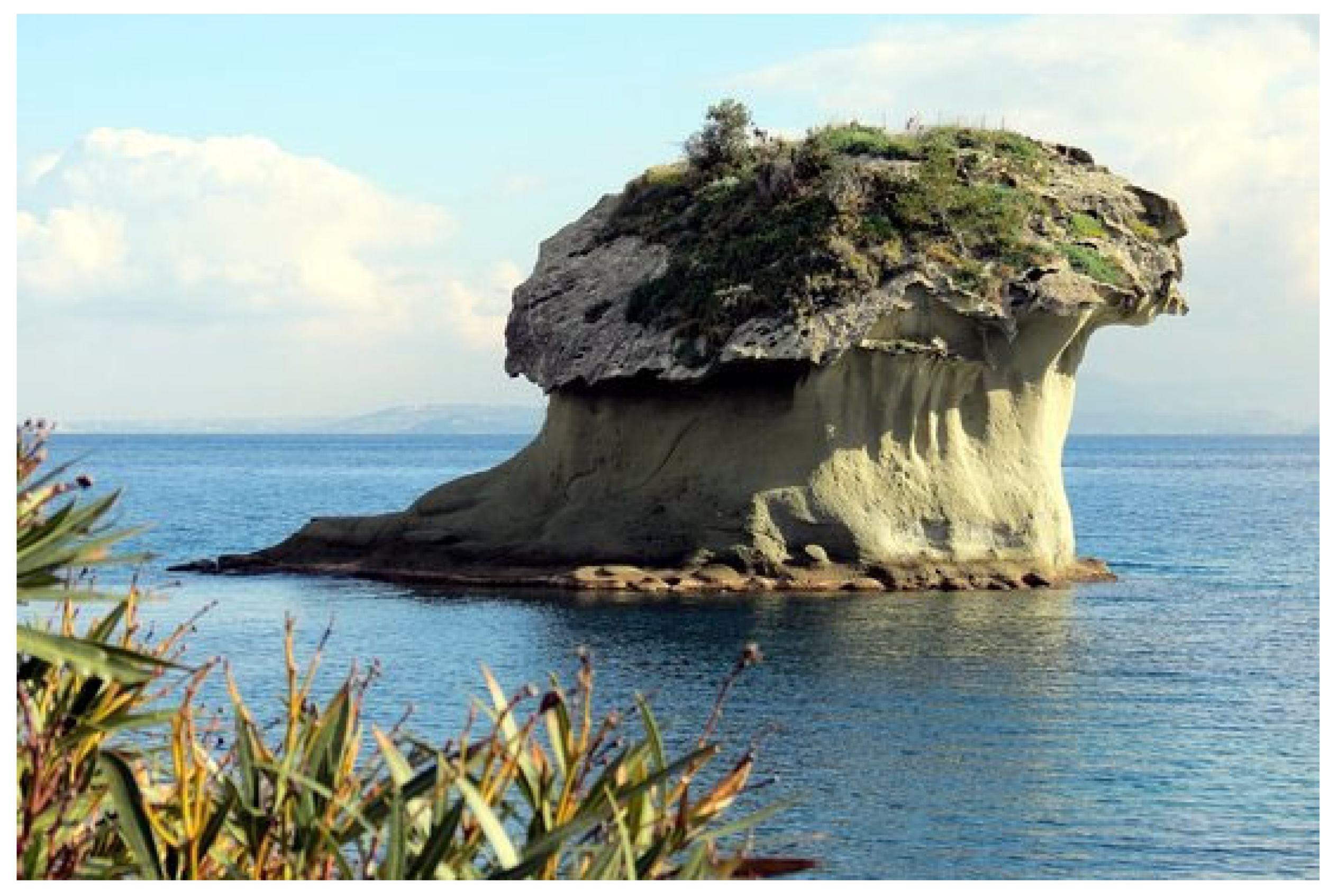
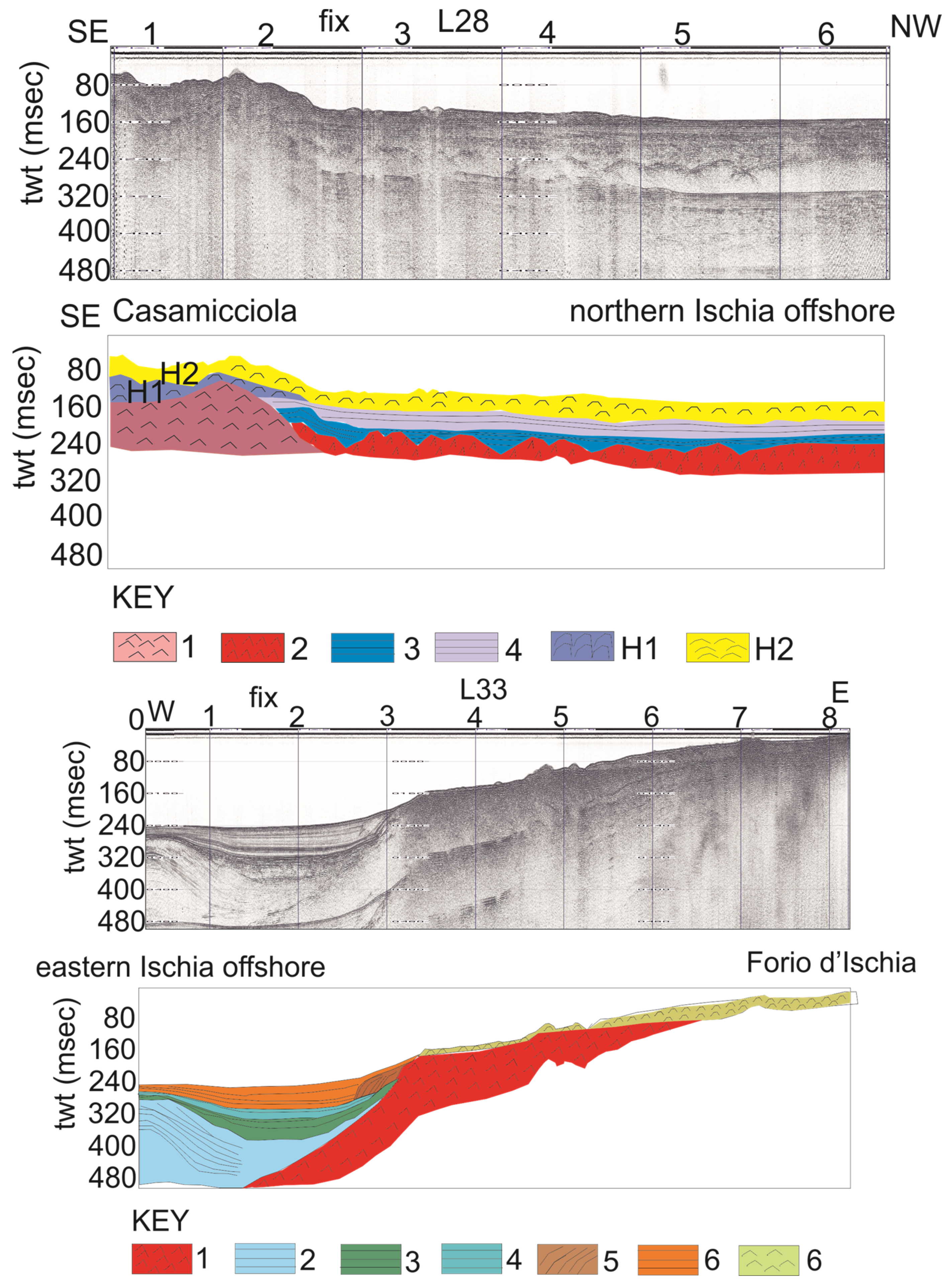
3.1. Gravitational Instability on the Naples Slope and Ischia Island

The submarine instability processes offshore of Campania mainly occur along the flanks of volcanic edifices, both emerged (Ischia Island) and submerged (Pentapalummo, Nisida, Miseno Banks, Procida Channel), on steep, tectonically-controlled sedimentary slopes, (southern slope of Sorrento Peninsula, slope of the Policastro Gulf), and on ramps with a low gradient that surround wide continental shelves (Gulf of Salerno).
There are also steep and intensely articulated slope typologies in threshold and depositional embankment areas and in channel areas from the development of tributary channels that drain high levels of water at the edge of extensive continental platforms (e.g., Cuma canyon; Figure 1). This kind of situation is shown by the Sub-bottom Chirp profile GA39N_1 and by the corresponding geological interpretation (Figure 1).
The submarine canyon of Cuma, a sizable, deep submerged valley that reaches a maximum depth of 800 m between the islands of Ischia and Ventotene, is in this area, which has a complex and varied topography (Figure 1). This canyon serves as a conveyance duct to the deep basin and speeds up upwelling, making it a great sedimentary basin for materials carried down the coast by the Volturno and Garigliano rivers. Seagrass meadows (Posidonia oceanica), stony banks, and rocky cliffs with coralligenous formations are features of the shelf area of Ischia Island in front of the canyon.
Digital Elevation Models of Naples Bay (Figure 2) and Ischia Island (Figure 3) are reported to highlight the main morpho-structural lineaments occurring in this area.
Significant debris avalanches have been singled out at Ischia Island, both onshore [32] and offshore [1,33,34,35,36,37]. Significant deformations occur onshore, including the Casamicciola debris avalanche, the Lacco Ameno debris avalanche, the Falanga debris avalanche, the Pietre Rosse debris avalanche, the Citrunia debris avalanche, the Ciglio debris avalanche, the Succhivo debris avalanche, the Casamicciola lahar, and others, more than the Chiarito rockslide and some debris slides, historical in age [32].
Important debris avalanches are in the northern, southern and western offshore sectors of the island. The most important one is the Ischia Debris Avalanche (IDA; Figure 4) [33]. The volumetric evaluation (Figure 4b), carried out based on the Digital Elevation Model (Figure 4a), has shown that the estimated volume of displaced materials is about 1.5 km2. This evaluation has been carried out by reconstructing a hypothetical slide mass along the blue line (Figure 4b).
The geological interpretation of the Sparker profile L32_06 has shown the geometrical characteristics of the debris avalanche deposits occurring in the western sector of Ischia (Punta del Soccorso; 6 in Figure 5). This unit crops out at the sea bottom with a wedge-shaped external geometry and is in facies heteropy with algal bioconstructions (6 in Figure 5). The volcanic acoustic basement (1 in Figure 5) is deeply eroded, and, in particular, a palaeo-valley can be identified. The seismo-stratigraphic units from 3 to 5 have shown a progradational seismic pattern (Figure 5).
Any attempt to contribute to the long-term evaluation of volcanic and related hazards in Ischia must consider the potentially dangerous phenomenon of slope instability, particularly debris avalanches and lahars with their great destructive force [1,31,32,33,34,35,36,37]. Apart from the devastating consequences that such occurrences may have on land, they have the capacity to produce massive tsunamis that could impact the nearby and heavily populated coastline region of the Neapolitan region.
Significant slope instabilities have been detected in the Naples slope surrounding the Dohrn and Magnaghi canyons (Figure 6) [38]. Among them are the retrogressive canyon’s head of the Dohrn eastern branch and the slide scars, which are concentrated in the lower, deeper sector of the Dohrn eastern branch, to the east of the Banco di Fuori morpho-structural high (Figure 6). The Multibeam bathymetric analysis did not show slide deposits in correspondence to the slide scars; hence, it was suggested that significant transport acted in the branches of the canyon.
Sedimentological data analysis has shown the prevalence of silty bioclastic sand in the Dohrn canyon, while other samples have shown a percentage of silt from 30% to 40%, a percentage of sand + gravel from 10% to 40%, and a percentage of shale from 30% to 40%. The ternary plot of the Magnaghi canyon shows that a single sample in the upper part of the diagram has a percentage of sand + gravel of 90%, and the occurrence of coarse-grained deposits may be inferred. Other samples are characterized by a percentage of sand + gravel up to 90% and by a percentage of silt from 60% to 100%.
A thin drape of hemipelagic deposits has been detected in the whole canyon system, as shown by the geological interpretation of seismic profiles (Figure 7a). This suggests their present-day inactivity, triggered by both the scarce volcaniclastic supply and by the relative sea-level highstand. Different examples of gravitational instabilities occur on the continental slope of Naples Bay, including the occurrence of evacuation surfaces associated with mass wasting (Figure 7b).

3.2. Theoretical Models of Slope Stability and Slope Analysis of the Naples Bay

Theoretical models on slope stability start from the slopes composed of dry, loose sand at whatever height. The basic condition is that the inclination β with respect to the horizontal is equal or minor to the inner friction angle ϕ of the loose sand.
The safety factor F of the slope with respect to the slide is expressed from the following equation:
F = t a n φ t a n β
It cannot exist a slope of sand with a gradient greater than ϕ, independently from its height.
In the case of Naples Bay, sedimentological maps have previously shown that the Naples slope is composed of sand and silty sand [7]. For this reason, we can assume that we are dealing with a sandy and silty submarine slope.
The analysis of bathymetric profiles along the canyon’s branches (Figure 8) has shown an overall evolution from erosional morphologies of the thalweg (V-shaped) towards depositional morphologies (U-shaped).
A progressive deepening towards the south of the whole canyon system, progressive evolution from retrogressive models in the head, and geological evolution from V-shaped to U-shaped have been observed, according to previous models on submarine canyon evolution [39,40,41,42].
Morpho-structural sketch maps, previously described [31], have been revised, focusing on the submarine gravity instabilities (Figure 9). The bathymetric data analysis has allowed us to distinguish the continental shelf from the continental slope. The Magnaghi canyon has three retrogressive heads, fed by tributary channels coming from the continental shelf and slope of the Procida Island. Here, slide scars occur. From the south of Ischia, it is possible to see the three abrasion terraces of south Ischia, including Maronti, and the terraced surface of the Ischia Bank (see also Figure 4a). A set of submarine canyons characterizes the Southern Ischia slope (Southern Ischia canyon system), including the S. Pancrazio canyon (see also Figure 4a). Numerous slide masses occur on the continental slope (Figure 9). Regarding the Dohrn canyon, the submarine gravity instabilities appear to be concentrated at the canyon’s head and in the lower section of the canyon, where the western slope is carved by numerous gullies (Figure 9). A significant along-slope transport is suggested by the lack of significant slide masses or slide deposits in correspondence to the main erosion areas.

3.3. The Influence of Shallow Gas on Gravitational Instabilities: The Volturno Offshore

Shallow gas has deeply influenced the triggering of submarine gravity instabilities, particularly in the study area, of creeping. They represent significant geohazards in the Southern Tyrrhenian region. The occurrence of shallow gas and gas hydrates has been recognized as a trigger factor of the submarine slope stability on the world’s continental margins [15,43,44,45,46]. Zhang and Hou [47] have recently shown that the creep characteristics can vary during gravitational deformation: from an expansion stage to an unstable expansion stage, to a fracture stage and finally, a post-fracture development stage.
Creeping has been defined as a strain that develops under constant load and is a time-dependent, slow process that can involve large masses of soil. Creep can occur under either drained or undrained loading conditions. The geomorphological data have suggested that the lack of a distinct failure scar has been linked to creep-induced sliding. The geophysical data suggested that inner deformation within seafloor subsoils occurs, which has been linked to creeping.
The geological interpretation of the Sub-bottom Chirp profile M198 has shown that creeping occurs offshore of the Volturno river mouth, which is associated with the occurrence of shallow gas pockets (Figure 10). Significant creep has also been observed offshore the Sarno river mouth [25], suggesting that on the Campania continental margin, creeping instabilities are concentrated at the rivers’ mouth (Volturno, Sarno), where a high sediment supply occurs.
The occurrence of small-scale faults associated with the creeping fits well with the creeping model by Zhang and Hou [47], who suggested a fracture stage during the later development of creeping.

4. Discussion

The results obtained show that different types of submarine instabilities occur offshore in Campania. They represent a significant geohazard and have been outlined by morpho-bathymetric and seismo-stratigraphic data. These data can be compared with the geological data on the adjacent onshore sectors of Southern Apennines, showing significant submarine gravity instabilities. In this area, volcanism and seismicity represent other significant geohazards, especially in the frame of the present-day bradyseismic crisis of the Campi Flegrei volcanic complex. A significant bradyseismic crisis is still in course due to the volcano-tectonic uplift of the Campi Flegrei caldera, and significant earthquakes occurred recently, creating a significant geohazard in the densely inhabited Naples town. As of the end of February 2025, the maximum volcano-tectonic uplift value reached in Rione Terra in Pozzuoli, representing the point of maximum caldera deformation, is about 140 cm, including about 22 cm since January 2024 (https://rischi.protezionecivile.gov.it/en/volcanic/volcanoes-italy/phlegraen-fields/bradyseism-phlegraean-fields/current-crisis/; accessed on 20 April 2025). This crisis is associated with a significant increase in the rate of seismicity in the Naples town and in the surrounding areas.
Starting in 2018, the volcano-tectonic uplift of the Campi Flegrei caldera was accompanied by a gradual increase in seismic activity, including the number of earthquakes and their magnitude. In 2023, while most events had low magnitudes (about 90% had magnitudes below 1.0), there was a new increase in the frequency of earthquakes [48]. Most of the seismic events occurred between Astroni, Solfatara–Pisciarelli–Agnano, Pozzuoli, and Gulf of Pozzuoli, with maximum depths of about 4 km, primarily concentrated in the first 2 km. At the moment, the volcano-tectonic uplift of the Campi Flegrei caldera and the consequent seismicity do not appear directly related to submarine gravity instabilities observed in the Naples area.
The submarine instabilities are represented by debris avalanches, slide scars and slide boulders, and creeping, often associated with shallow gas.
The debris avalanches of Ischia occur in the northern, western and southern sectors of the island. Important debris avalanches occur in the onshore sector. Onshore, an important debris avalanche is shown by the so-called “Lacco Ameno mushroom”, a characteristic debris avalanche morphology (https://www.tripadvisor.it/LocationPhotoDirectLink-g1201044-d2086693-i245719897-Grand_Hotel_delle_Terme_Re_Ferdinando-Ischia_Porto_Ischia_Isola_d_Ischi.html; accessed on 20 April 2025; Figure 11).
Based on the volcanic data [32], a sketch table (Table 1) integrating the onshore debris avalanches with the offshore ones has been constructed in order to put these submarine gravity instabilities in a proper chrono-stratigraphic framework.
These submarine instabilities are in some way related to the tephrostratigraphic framework of Ischia, which has been the subject of several studies. Among them, the study of Brown et al. [51] (Figure 12a) is one of the most important. The tephrostratigraphic setting proposed by Brown et al. [51] is shown in Figure 12a, while a significant seismic profile in the Southern Ischia canyon system is shown in Figure 12b. Vineberg et al. [52] have recently updated the tephrostratigraphic results of Brown et al. [51], producing a detailed tephrostratigraphy for pre-CI eruption activity using the units preserved within a sequence at the coastal Acquamorta outcrop on the western side of the CI caldera rim (Campi Flegrei).
The comparison with previous studies has confirmed the occurrence of submarine instabilities offshore Campania, and their importance is noteworthy. The obtained morpho-bathymetric and seismo-stratigraphic results can be compared with the recent morpho-bathymetric results obtained by Foglini et al. [9] and Budillon et al. [21] for the Bay of Naples. Table 1 compares the obtained results with the existing geological literature on Ischia, referring, in particular, to the debris avalanches [1,32,49,50,51,53].
Foglini et al. [9] have compared the DEM of Naples Bay previously shown by Aiello et al. [6], merging it with the elevation and bathymetric data of the EMODnet bathymetry project (https://emodnet.ec.europa.eu/en/bathymetry; accessed on 20 April 2025). Moreover, the existing morpho-bathymetric data have been merged with the recent Multibeam survey of Naples Bay (JammeGaia22 oceanographic cruise, October 2022, R/V Gaia Blu). The R/V Gaia Blu (CNR, Italy) is equipped with three different Multibeam systems (Kongsberg EM 2040, EM 712, and EM 304). In this paper, the bathymetric data of the Naples canyons have been newly analyzed, highlighting the slope maps and the bathymetric position index (BPI). These data are fully consistent with previous slope maps constructed in Naples Bay and reported in this paper (Figure 9) [31]. Three areas prone to sliding exist, including the Naples canyons, the Southern Ischia slope, and the Southern Sorrento–Peninsula Capri slope, as reported in the previous geological literature existing on the area [31].

5. Conclusions

Important submarine gravity instabilities have been identified offshore of the Campania region. The morpho-bathymetric analysis has allowed us to identify the main gravitational instabilities, and the areas prone to sliding in Naples Bay have been reassessed. Creeping has been identified as a main process of submarine gravity instabilities, mainly at the Volturno and Sarno river mouths, where the occurrence of shallow gas coupled with a high sedimentary supply has acted as the main control factor triggering submarine slope instability. Further studies will include the quantitative slope stability analysis of the sandy and silty slopes of Naples Bay based on geotechnical modeling. One of the main limits of this research is the lack of a systematic network of samples, which prevents us from calibrating the seismo-stratigraphic network and constructing an age model of submarine instability deposits based on radiometric dating. Based on the previous literature data, this kind of work has been performed only by De Alteriis et al. [34] on the Ischia Debris Avalanche (IDA), based on a dense network of cores drilling the debris avalanche deposits (Figure 13). This has allowed for a better knowledge of the age of these deposits based on radiometric dating. The stratigraphic record has shown two collapse events, including the Ischia submarine debris avalanche/debris flow (DA/DF), dated between ~3 ka B.P. and 2.4 ka B.P. and possibly between 2.7 ka B.P. and 2.4 ka B.P. (event DF1), and a former, pre-Holocene, DA/DF older than 23 cal ka B.P. (event DF2) [34]. The acquisition of further cores, coupled with tephrostratigraphic studies, will allow for a better knowledge of the age of the emplacement of submarine instability deposits.
Another limit of this research is linked to the technological content of the Digital Elevation Models used for geomorphological analysis, which could be solved in the future through the acquisition of a systematic Multibeam survey of the Campania continental shelf and slope using the updated MBEs, which are installed on the R/V Gaia Blu of the National Research Council of Italy (CNR).

Funding

This research received no external funding.

Data Availability Statement

No new data were created or analyzed in this study.

Conflicts of Interest

The author declares no conflicts of interest.

References

  1. Aiello, G.; Marsella, E.; Passaro, S. Submarine instability processes on the continental slopes off the Campania region (southern Tyrrhenian Sea, Italy): The case history of Ischia Island (Naples Bay). Boll. Geofis. Teor. Appl. 2009, 50, 193–207. [Google Scholar]
  2. Milia, A.; Torrente, M.M.; Giordano, F. Chapter 4 Gravitational instability of submarine volcanoes offshore Campi Flegrei (Naples Bay, Italy). In Developments in Volcanology, 1st ed.; De Vivo, B., Ed.; Elsevier: Amsterdam, The Netherlands, 2006; Volume 9, pp. 69–83. [Google Scholar] [CrossRef]
  3. Rosi, M.; Sbrana, A. Phlegrean Fields; CNR, National Research Council of Italy, Scientific Monograph: Rome, Italy, 1987. [Google Scholar]
  4. Steinmann, L.; Spiess, V.; Sacchi, M. The Campi Flegrei caldera (Italy): Formation and evolution in interplay with sea-level variations since the Campanian Ignimbrite eruption at 39ka. J. Volcanol. Geotherm. Res. 2016, 327, 361–374. [Google Scholar] [CrossRef]
  5. Sbrana, A.; Marianelli, P.; Pasquini, G. The Phlegrean Fields volcanological evolution. J. Maps 2021, 17, 557–570. [Google Scholar] [CrossRef]
  6. Aiello, G.; Iorio, M.; Molisso, F.; Sacchi, M. Integrated Morpho-Bathymetric, Seismic-Stratigraphic, and Sedimentological Data on the Dohrn Canyon (Naples Bay, Southern Tyrrhenian Sea): Relationships with Volcanism and Tectonics. Geosciences 2020, 10, 319. [Google Scholar] [CrossRef]
  7. Aiello, G.; Caccavale, M. The Coastal Areas of the Bay of Naples: The Sedimentary Dynamics and Geological Evolution of the Naples Canyons. Geosciences 2023, 13, 226. [Google Scholar] [CrossRef]
  8. Di Fiore, V.; Aiello, G.; D’Argenio, B. Gravity instabilities in the Dohrn Canyon (Bay of Naples, Southern Tyrrhenian Sea): Potential wave and run-up (tsunami) reconstruction from a fossil submarine landslide. Geol. Carpathica 2011, 62, 55–63. [Google Scholar] [CrossRef]
  9. Foglini, F.; Rovere, M.; Tonielli, R.; Castellan, G.; Prampolini, M.; Budillon, F.; Cuffaro, M.; Di Martino, G.; Grande, V.; Innangi, S.; et al. A new multi-grid bathymetric dataset of the Gulf of Naples (Italy) from complementary multi-beam echo sounders. Earth Syst. Sci. Data 2025, 17, 181–203. [Google Scholar] [CrossRef]
  10. Aiello, G. Regional Geological Data of the Volturno basin filling and relationships with the Massico structure. J. Mar. Sci. Eng. 2025, 13, 241. [Google Scholar] [CrossRef]
  11. Varnes, D.J. Landslide types and processes. In Landslides and Engineering Practice, Special Report 28. Highway Research Board; Eckel, E.B., Ed.; National Academy of Sciences: Washington, DC, USA, 1954; pp. 20–47. [Google Scholar]
  12. Hungr, O.; Leroueil, S.; Picarelli, L. The Varnes classification of landslide types, an update. Landslides 2013, 11, 167–194. [Google Scholar] [CrossRef]
  13. Terzaghi, K.; Peck, R. Soil Mechanics in Engineering Practice, 2nd ed.; John Wiley & Sons: Hoboken, NJ, USA, 1996. [Google Scholar]
  14. Edil, T.B.; Vallejo, L.E. Mechanics of coastal landslides and the influence of slope parameters. Eng. Geol. 1980, 16, 83–96. [Google Scholar] [CrossRef]
  15. Aiello, G.; Caccavale, M. New Seismoacoustic Data on Shallow Gas in Holocene Marine Shelf Sediments, Offshore from the Cilento Promontory (Southern Tyrrhenian Sea, Italy). J. Mar. Sci. Eng. 2022, 10, 1992. [Google Scholar] [CrossRef]
  16. Aiello, G.; Marsella, E.; Di Fiore, V.; D’Isanto, C. Stratigraphic and structural styles of half-graben offshore basins: Multichannel seismic and Multibeam morpho-bathymetric evidences on the Salerno Valley (Southern Campania continental margin, Italy). Quad. Geofis. 2009, 77, 1–34. [Google Scholar]
  17. Biscontin, G.; Pestana, J.M. Factors affecting seismic response of submarine slopes. Nat. Hazards Earth Syst. Sci. 2006, 6, 97–107. [Google Scholar] [CrossRef]
  18. Cukur, D.; Kim, S.P.; Kong, G.S.; Bahk, J.; Horozal, S.; Um, I.; Lee, G.; Chang, T.; Ha, H.; Volker, D.; et al. Geophysical evidence and inferred triggering factors of submarine landslides on the western continental margin of the Ulleung Basin, East Sea. Geo-Mar. Lett. 2016, 36, 425–444. [Google Scholar] [CrossRef]
  19. Jing, S. Triggers, Mechanisms and Frequency of Slope Instability Processes on Mid-Norway’s Continental Margin. Ph.D. Thesis, Cardiff University, Cardiff, UK, June 2023. [Google Scholar]
  20. Chiocci, F.L.; Cattaneo, A.; Urgeles, R. Seafloor mapping for geohazard assessment: State of the art. Mar. Geophys. Res. 2011, 32, 1–11. [Google Scholar] [CrossRef]
  21. Budillon, F.; Martorelli, E.; Conforti, A.; De Falco, G.; Bosman, A.; Di Martino, G.; Firetto Carlino, M.; Innangi, S.; Pierdomenico, M.; Sposato, A.; et al. Geohazard features of the Gulf of Naples and Pontine Islands (Eastern Tyrrhenian Sea). J. Maps 2024, 20. [Google Scholar] [CrossRef]
  22. Mitchum, R.M.; Vail, P.R.; Thompson, S. Seismic stratigraphy and global changes of sea-level, part 2: The depositional sequence as a basic unit for stratigraphic analysis. In Seismic Stratigraphy—Applications to Hydrocarbon Exploration; Memoir 26; Payton, C.E., Ed.; American Association of Petroleum Geologists: Tulsa, OK, USA, 1977; pp. 53–62. [Google Scholar]
  23. Vail, P.R.; Mitchum, R.M.; Thompson, S. Seismic stratigraphy and global changes of sea level, part IV: Global cycles of relative changes of sea level. In Seismic Stratigraphy—Applications to Hydrocarbon Exploration; Memoir 26; Payton, C.E., Ed.; American Association of Petroleum Geologists: Tulsa, OK, USA, 1977; pp. 83–98. [Google Scholar]
  24. Catuneanu, O.; Abreu, V.; Bhattacharya, J.P.; Blum, M.D.; Dalrymple, R.W.; Eriksson, P.G.; Fielding, C.R.; Fisher, W.L.; Galloway, W.E.; Gibling, M.R.; et al. Towards the standardization of sequence stratigraphy. Earth-Sci. Rev. 2009, 92, 1–33. [Google Scholar] [CrossRef]
  25. Aiello, G.; Budillon, F.; Cristofalo, G.; D’Argenio, B.; de Alteriis, G.; De Lauro, M.; Ferraro, L.; Marsella, E.; Pelosi, N.; Sacchi, M.; et al. Marine Geology and Morphobathymetry in the Bay of Naples (South-Eastern Tyrrhenian Sea, Italy). In Mediterranean Ecosystems; Faranda, F.M., Guglielmo, L., Spezie, G., Eds.; Springer: Milano, Italy, 2001. [Google Scholar] [CrossRef]
  26. D’Argenio, B.; Aiello, G.; de Alteriis, G.; Milia, A.; Sacchi, M. Digital Elevation Model of the Naples Bay and Adjacent Areas, Eastern Tyrrhenian Sea. In Mapping Geology in Italy; Pasquarè, E., Venturini, G., Eds.; Atlante di Cartografia Geologica: Firenze, Italy, 2004; pp. 21–28. [Google Scholar]
  27. Somma, R.; Iuliano, S.; Matano, F.; Molisso, F.; Passaro, S.; Sacchi, M.; De Natale, G. High-resolution morpho-bathymetry of Pozzuoli Bay, southern Italy. J. Maps 2015, 12, 222–230. [Google Scholar] [CrossRef]
  28. Passaro, S.; Tamburrino, S.; Vallefuoco, M.; Gherardi, S.; Sacchi, M.; Ventura, G. High-resolution morpho-bathymetry of the Gulf of Naples, Eastern Tyrrhenian Sea. J. Maps 2016, 12, 203–210. [Google Scholar] [CrossRef]
  29. Iorio, M.; Meo, A.; Aiello, G.; Senatore, M.R. The Neapolitan Yellow Tuff record in the Gaeta Gulf (Eastern Tyrrhenian margin, Southern Italy). Adv. Geosci. 2024, 63, 15–27. [Google Scholar] [CrossRef]
  30. Gianardi, R.; Bisson, M.; Cocchi, L.; Isaia, R.; Passaro, S.; Sepe, V.; Spinetti, C. From land to sea: A new high-resolution bathymetry and topography of the Campi Flegrei area, Southern Italy. J. Maps 2024, 20, 2404873. [Google Scholar] [CrossRef]
  31. Aiello, G.; Sacchi, M. New morpho-bathymetric data on marine hazard in the offshore of Gulf of Naples (Southern Italy). Nat. Hazards 2022, 111, 2881–2908. [Google Scholar] [CrossRef]
  32. Della Seta, M.; Marotta, E.; Orsi, G.; De Vita, S.; Sansivero, F.; Fredi, P. Slope instability induced by volcano-tectonics as an additional source of hazard in active volcanic areas: The case of Ischia island (Italy). Bull. Volcanol. 2012, 74, 79–106. [Google Scholar] [CrossRef]
  33. Chiocci, F.L.; de Alteriis, G. The Ischia debris avalanche: First clear submarine evidence in the Mediterranean of a volcanic island prehistorical collapse. Terra Nova 2006, 18, 202–209. [Google Scholar] [CrossRef]
  34. De Alteriis, G.; Insinga, D.D.; Morabito, S.; Morra, V.; Chiocci, F.L.; Terrasi, F.C.; Lubritto, C.C.; Di Benedetto, C.; Pazzanese, M. Age of submarine debris avalanches and tephrostratigraphy offshore Ischia Island, Tyrrhenian Sea, Italy. Mar. Geol. 2010, 278, 1–18. [Google Scholar] [CrossRef]
  35. Aiello, G.; Marsella, E.; Passaro, S. Stratigraphic and structural setting of the Ischia volcanic complex (Naples Bay, Southern Italy) revealed by submarine seismic reflection data. Rend. Fis. Acc. Lincei 2012, 23, 387–408. [Google Scholar] [CrossRef]
  36. Aiello, G.; Caccavale, M. Quaternary Evolution of Ischia: A Review of Volcanology and Geology. Appl. Sci. 2023, 13, 3554. [Google Scholar] [CrossRef]
  37. Milia, A.; Aiello, G.; Iannace, P.; Torrente, M.M. Complex stratigraphic relationships between volcanic features and sedimentary deposits in a submarine environment: The northern offshore Holocene Ischia volcanic field (Italy). J. Volcanol. Geotherm. Res. 2021, 419, 107379. [Google Scholar] [CrossRef]
  38. Ruggieri, S.; Aiello, G.; Marsella, E. Integrated marine geophysical data interpretation of the Naples Bay continental slope (southern Tyrrhenian Sea, Italy). Boll. Di Geofiisica Teor. Appl. 2007, 48, 1–24. [Google Scholar]
  39. Fusi, N.; Mirabile, L.; Camerlenghi, A.; Ranieri, G. Marine geophysical survey of the Gulf of Naples (Italy): Relationships between submarine volcanic activity and sedimentation. Mem. Soc. Geol. It. 1991, 47, 95–114. [Google Scholar]
  40. Pratson, L.F.; Coakley, B.J. A model for the headward erosion of submarine canyons induced by downslope eroding sedimentary flows. Geol. Soc. Am. Bull. 1986, 108, 225–234. [Google Scholar] [CrossRef]
  41. Cronin, B.T.; Akhmetzhanov, A.M.; Mazzini, A.; Akhmanov, G.; Ivanov, M.; Kenyon, N.H. Morphology, evolution and fill: Implications for sand and mud distribution in filling deep-water canyons and slope channel complexes. Sediment. Geol. 2005, 179, 71–97. [Google Scholar] [CrossRef]
  42. Harris, P.T.; Whiteway, T. Global distribution of large submarine canyons: Geomorphic differences between active and passive continental margins. Mar. Geol. 2011, 285, 69–86. [Google Scholar] [CrossRef]
  43. Sultan, N.; Cochonat, P.; Canals, M.; Cattaneo, A.; Dennielou, B.; Haflidason, H.; Laberg, J.S.; Long, D.; Mienert, J.; Trincardi, F.; et al. Triggering mechanisms of slope instability processes and sediment failures on continental margins: A geotechnical approach. Mar. Geol. 2004, 213, 291–321. [Google Scholar] [CrossRef]
  44. Daigle, H.; Cook, A.; Fang, Y.; Bihani, A.; Song, W.; Flemings, P.B. Gas-driven tensile fracturing in shallow marine sediments. J. Geophys. Res. Solid Earth 2020, 125, e2020JB020835. [Google Scholar] [CrossRef]
  45. Karstens, J.; Jonas Preine, J.; Carey, S.; Katherine, L.C.; Bell, K.L.C.; Nomikou, P.; Hübscher, C.; Lampridou, D.; Urlaub, M. Formation of undulating seafloor bedforms during the Minoan eruption and their implications for eruption dynamics and slope stability at Santorini. Earth Planet. Sci. Lett. 2023, 616, 118215. [Google Scholar] [CrossRef]
  46. Jin, J.; Hu, J.; Li, L.; Li, J.; Zhu, Z.; Wang, X.; Zhou, J.; Wang, W. Submarine Slides and Their Influence on Gas Hydrate and Shallow Gas in the Pearl River Mouth Basin. J. Mar. Sci. Eng. 2025, 13, 308. [Google Scholar] [CrossRef]
  47. Zhang, C.; Hou, J. Creep characteristics of muddy submarine channel slope instability. Front. Mar. Sci 2022, 9, 999151. [Google Scholar] [CrossRef]
  48. Del Pezzo, E.; Bianco, F. Space and time distribution of seismic source energy at Campi Flegrei, Italy through the last unrest phase (1.1.2000–31.12.2023). Phys. Earth Planet. Inter. 2024, 356, 107258. [Google Scholar] [CrossRef]
  49. De Alteriis, G.; Violante, C. Catastrophic landslides off Ischia volcanic island (Italy) during prehistory. Geol. Soc. Lond. Spec. Publ. 2009, 322, 73–104. [Google Scholar] [CrossRef]
  50. de Vita, S.; Fabio Sansivero, F.; Giovanni Orsi, G.; Enrica Marotta, E. Cyclical slope instability and volcanism related to volcano-tectonism in resurgent calderas: The Ischia island (Italy) case study. Eng. Geol. 2006, 86, 148–165. [Google Scholar] [CrossRef]
  51. Brown, R.; Orsi, G.; de Vita, S. New insights into Late Pleistocene explosive volcanic activity and caldera formation on Ischia (southern Italy). Bull. Volcanol. 2008, 70, 583–603. [Google Scholar] [CrossRef]
  52. Vineberg, S.O.; Isaia, R.; Albert, P.G.; Brown, R.G.; Smith, V.C. Insights into the explosive eruption history of the Campanian volcanoes prior to the Campanian Ignimbrite eruption. J. Volcanol. Geotherm. Res. 2023, 443, 107915. [Google Scholar] [CrossRef]
  53. Aiello, G.; Marsella, E. The Southern Ischia Canyon System: Examples of Deep Sea Depositional Systems on the Continental Slope off Campania. Rend. Online Della Soc. Geol. Ital. 2014, 32, 28–37. [Google Scholar] [CrossRef]
Figure 1. Sub-bottom Chirp profile GA39N_1 (Cuma canyon) and corresponding geological interpretation. Note the occurrence of a dense network of channels pertaining to the Cuma canyon system.
Geohazards 06 00020 g001
Figure 2. Digital Elevation Model of the Naples Bay (modified after Aiello et al. [25]). IB: Ischia Bank. GB: Gaia Bank. AC: Ammontatura canyon. MB: Miseno Bank. PPB: Pentapalummo Bank. MDB: Monte Dolce Bank. NB: Nisida Bank. The location of the profile in Figure 1 has been reported. The inset on the lower right side of the figure shows the DEM location in Italy.
Geohazards 06 00020 g002
Figure 3. Digital Elevation Model of Ischia Island. Note the emerged portion of the volcanic edifice and the flat terraced surfaces that characterize the submarine portion of the Ischia volcano in its southern part. A dense network of canyons occurs. In the south-eastern offshore, the submarine Ischia bank can be seen.
Geohazards 06 00020 g003
Figure 4. (a) Digital Elevation Model of Ischia Island. Note the emerging portion of the volcanic edifice and the Ischia Debris Avalanche as a tongue of blocks clearly distinguished in the DEM, whose volumetric evaluation is reported in (b). The Epomeo caldera rim (red line) has also been reported. Note the occurrence of a main system of submarine canyons (Southern Ischia, S. Pancrazio) and of the relict volcano of the Ischia Bank.
Geohazards 06 00020 g004
Figure 5. Seismic profile L32_06 and corresponding geological interpretation. Key. 1: Volcanic acoustic basement; 2: seismo-stratigraphic unit of the Ischia basin filling; 3: seismo-stratigraphic unit of the Ischia basin filling; 4: progradational seismo-stratigraphic unit; 5: progradational seismo-stratigraphic unit (shelf margin); 6: debris avalanche; 6: algal patch reefs (facies heteropy with debris avalanche).
Geohazards 06 00020 g005
Figure 6. Geomorphological map of the Dohrn and Magnaghi canyons (modified after Ruggieri et al.) [38]. Key: 1: volcanic morphostructural high; 2: relic morphology of the Middle-Late Pleistocene continental shelf; 3: areas involved by significant submarine slope instability; 4: turbidite slope fan; 5: canyon’s wall; 6: shelf break; 7: carbonatic morpho-structural high; 8: slope of palaeo-canyon; 9: drainage axis; 10: slide scar; 11: canyon’s axis; 12: normal fault.
Geohazards 06 00020 g006
Figure 7. (a) Sub-bottom Chirp profile Gp23; (b) Sub-bottom Chirp profile NA18, showing different submarine gravitational instabilities occurring on the Naples slope.
Geohazards 06 00020 g007
Figure 8. (a) Bathymetric map of the Naples slope and location of bathymetric profiles; (b) bathymetric profiles in the Dohrn canyon system; (c) bathymetric profiles in the Magnaghi canyon system (modified after D’Argenio et al. [26].
Geohazards 06 00020 g008aGeohazards 06 00020 g008b
Figure 9. Morpho-structural sketch maps of the Naples continental shelf and slope.
Geohazards 06 00020 g009
Figure 10. Sub-bottom Chirp profile M198. Note the occurrence of creeping slope instability associated with shallow gas pockets. A dense network of small-scale normal faults has been observed based on geological interpretation, in overall agreement with the creeping models [47].
Geohazards 06 00020 g010
Figure 11. The Lacco Ameno mushroom, a characteristic debris avalanche morphology (photograph after, https://www.tripadvisor.it/LocationPhotoDirectLink-g1201044-d2086693-i245719897-Grand_Hotel_delle_Terme_Re_Ferdinando-Ischia_Porto_Ischia_Isola_d_Ischi.html; accessed on 20 April 2025).
Geohazards 06 00020 g011
Figure 12. (a) Tephro-stratigraphy of Ischia based on Brown et al. 2008 [51]. (b) The seismo-stratigraphic setting of the Southern Ischia canyon system based on Aiello and Marsella 2015 [53].
Geohazards 06 00020 g012
Figure 13. Interpreted seismic profiles of the Ischia offshore, respectively, showing the Casamicciola and the Forio debris avalanche deposits and the surrounding seismo-stratigraphic units.
Geohazards 06 00020 g013
Table 1. Characteristics of the main debris avalanches of Ischia.
Gravitational
Instability
OnshoreInferred AgeOffshoreSeismic FaciesVolcano-Tectonic
Event
Debris avalanche (DA)Lacco Ameno DA
(onshore)
>6.0 ka B.P.; upper age boundary is given by the overlying beach deposits (Mezzavia sequence);
Holocene s.l. (based on De Alteriis and Violante, 2009) [49]
Seismo-stratigraphic unit of the Lacco Ameno DA (offshore)Wedge-shaped
Acoustically
transparent
Triggered by a volcano-tectonic event, based on the similarity with other historical debris avalanches documented in this area
Debris avalanchePietre Rosse DA (onshore)Overlying the Citara Formation (40 ky B.P.); Holocene s.l. based on De Alteriis and Violante, 2009 [49]Seismo-stratigraphic unit of the Forio DA (Punta del Soccorso; Figure 5)Chaotic to discontinuous seismic reflectorsTriggered by a volcano-tectonic event, based on the similarity with other historical debris avalanches documented in this area
Debris avalancheCasamicciola DA (onshore)≤Eight century B.C. The lower age boundary is given by the underlying deposits of the Punta La Scrofa tephra based on De Vita et al., 2006 [50]Seismo-stratigraphic unit of the Casamicciola DA (Casamicciola offshore; based on Aiello et al., 2009 [1]Chaotic to discontinuous seismic reflectorsTriggered by a volcano-tectonic event, based on the similarity with other historical debris avalanches documented in this area
Debris avalancheIschia DA (onshore). Slide scar involving the whole southern flank of the island.Historical
(based on the core data shown by De Alteriis et al. (2010) [34]
Seismo-stratigraphic unit of the IDA (De Alteriis et al.) [34]Hummocky
Occurrence of giant blocks, whose dimensions decrease, proceeding southwards
Volcano-tectonic scar of the southern flank of the island
Disclaimer/Publisher’s Note: The statements, opinions and data contained in all publications are solely those of the individual author(s) and contributor(s) and not of MDPI and/or the editor(s). MDPI and/or the editor(s) disclaim responsibility for any injury to people or property resulting from any ideas, methods, instructions or products referred to in the content.

