1. Introduction
Armenia is located within the central segment of the Arabia–Eurasia continental collision zone, one of the most tectonically active regions of the Alpine–Himalayan belt. Ongoing convergence between the Arabian and Eurasian plates (~15–20 mm/yr) produces distributed crustal deformation across the Lesser Caucasus and generates a complex network of active faults capable of producing strong earthquakes [
1,
2,
3,
4].
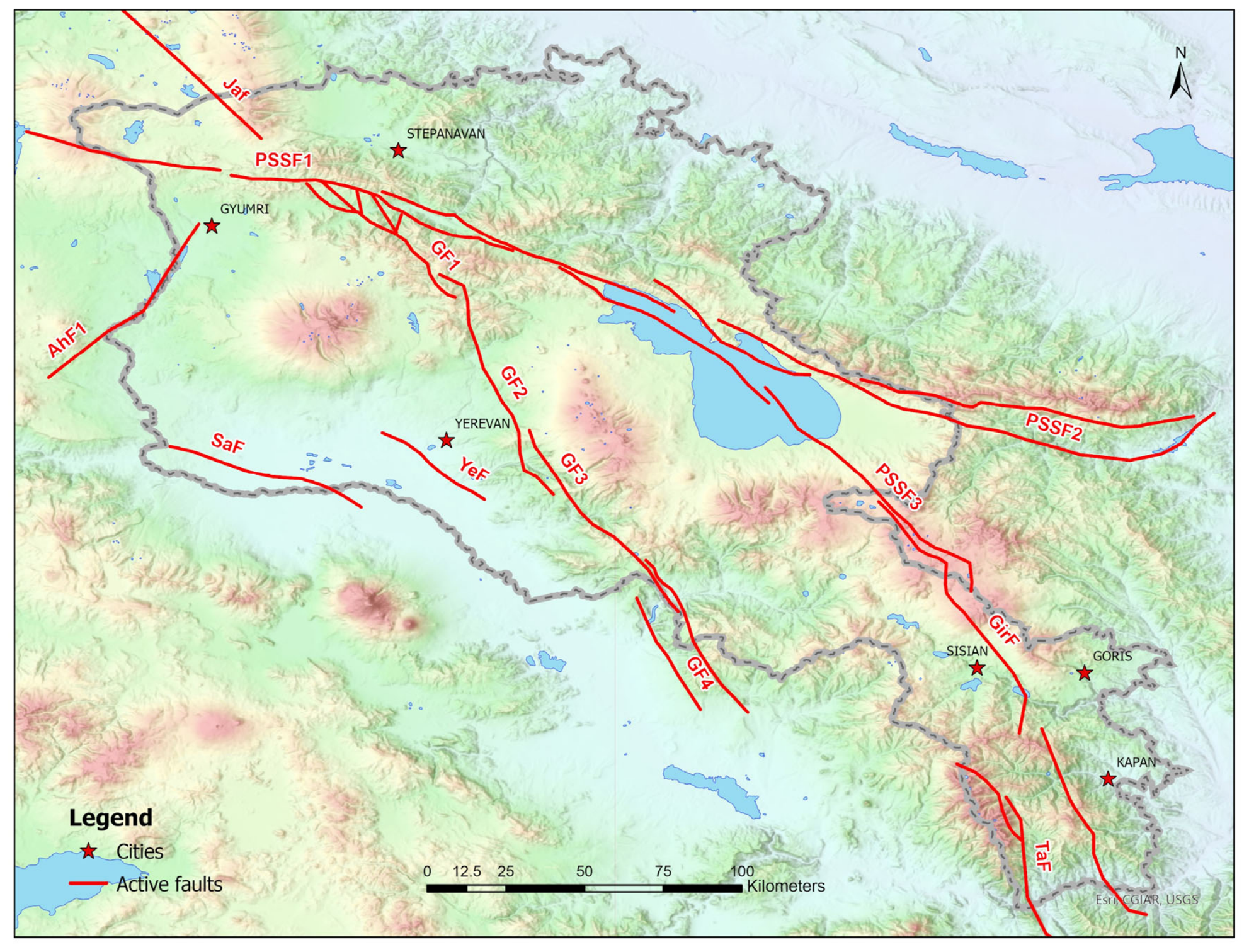
The tectonic framework of Armenia is dominated by several major active fault systems, including the Pambak–Sevan–Syunik, Garni, Akhuryan, and Giratagh fault zones (
Figure 1), which are capable of generating earthquakes exceeding Mw 7.0 [
5,
6]. Paleoseismological investigations, historical records, and instrumental seismicity indicate repeated occurrence of destructive earthquakes throughout the Armenian Highland during both historical and prehistoric periods [
7,
8,
9,
10]. Several of these fault systems pass in close proximity to the investigated cities and therefore represent significant potential sources of damaging earthquake ground motion.
The destructive 1988 Spitak earthquake (Mw 6.9) demonstrated the exceptionally high seismic vulnerability of Armenian urban areas, causing approximately 25,000 fatalities and widespread structural damage in Spitak, Gyumri, and Vanadzor [
11]. The earthquake highlighted the combined influence of strong ground shaking, unfavorable site conditions, vulnerable building stock, and insufficient seismic resilience of urban infrastructure. Although significant progress has since been achieved in seismic hazard assessment, seismic microzonation, and earthquake-resistant design practices, substantial seismic vulnerability remains in many Armenian cities because of aging building stock, heterogeneous construction quality, rapid urban development, and uneven implementation of seismic-retrofitting measures.
In addition to seismic hazard intensity, urban seismic vulnerability in Armenia is strongly controlled by the heterogeneous condition of the existing building stock, particularly the large proportion of masonry-dominated and pre-1988 residential structures constructed prior to the implementation of modern seismic design standards. These conditions contribute to pronounced spatial variability in expected earthquake impacts across Armenian urban environments.
Previous earthquake observations and seismic microzonation studies conducted in Armenia have additionally demonstrated the important influence of local geological conditions and site-amplification effects on the spatial distribution of earthquake damage within urban areas [
7,
11,
12,
13]. In several Armenian cities, local site conditions have been shown to intensify ground shaking and significantly increase the concentration of severe structural damage during strong earthquake events.
Probabilistic seismic hazard assessment (PSHA) provides important information about the likelihood of future ground shaking; however, it does not directly evaluate the expected consequences of specific earthquake events on urban environments. In contrast, scenario-based seismic risk assessment enables estimation of potential building damage, displacement, casualties, and emergency-response requirements associated with plausible deterministic earthquake scenarios.
Such approaches are particularly important in Armenia, where major urban centers are located close to active fault systems and are characterized by vulnerable building stock with significant spatial variability in structural conditions, local geological environments, and population exposure.
Recent advances in urban seismic risk assessment have increasingly focused on the integration of seismic hazard, exposure, and vulnerability information within GIS-based frameworks to support risk-informed decision making. Kazantzidou-Firtinidou et al. developed a scenario-based seismic risk assessment method for Cyprus, demonstrating the value of deterministic earthquake scenarios for estimating potential losses and supporting emergency management at the national scale [
14]. Xofi et al. proposed a census-based approach for urban seismic vulnerability assessment in the Lisbon Metropolitan Area, emphasizing the importance of detailed exposure characterization and vulnerability mapping for large urban environments [
15]. Similarly, Baldassarre et al. highlighted the role of seismic risk assessment in urban planning and resilience-oriented decision making through the integration of risk indicators into territorial management strategies [
16]. Collectively, these studies demonstrate the growing shift toward integrated and spatially explicit seismic risk assessment frameworks that support disaster risk reduction, emergency preparedness, and long-term urban resilience planning.
Despite previous seismic hazard and city-scale scenario studies conducted in Armenia, a unified comparative seismic risk assessment integrating multiple major Armenian urban centers within a consistent framework has not yet been presented. Furthermore, the spatial variability of urban vulnerability, exposure distribution, local site amplification, and expected earthquake impacts across different Armenian cities remains insufficiently investigated at the national scale [
17,
18,
19,
20].
In this study, we present an integrated comparative scenario-based seismic risk assessment for six Armenian cities, including Yerevan, Gyumri, Stepanavan, Kapan, Goris, and Sisian. The analysis combines seismotectonic source characterization, deterministic ground-motion modeling, site-condition assessment, urban exposure databases, and structural vulnerability analysis within a GIS-based framework using the ELER (Earthquake Loss Estimation Routine, ELER v3.0) platform [
21].
The principal objective of this study is to develop and apply an integrated scenario-based seismic risk assessment framework for six Armenian cities by combining hazard characterization, Vs30-based site effects, GIS-based exposure modeling, and vulnerability calibration using observations from the 1988 Spitak earthquake. Particular attention is given to the influence of local site conditions, building typology, exposure concentration, and method uncertainty on the spatial distribution of expected earthquake losses. The obtained results may support seismic-risk reduction strategies, urban planning, emergency preparedness, and long-term seismic-resilience development in Armenia.
2. Method of Scenario-Based Seismic Risk Assessment
2.1. General Workflow
The framework adopted in this study integrates seismotectonic source characterization, site-condition assessment, exposure modeling, vulnerability analysis, and earthquake loss estimation within a unified GIS-based seismic risk assessment environment. The framework was developed to provide a consistent comparative evaluation of potential earthquake impacts in six Armenian cities: Yerevan, Gyumri, Stepanavan, Kapan, Goris, and Sisian.
The analysis begins with the development of a regional seismotectonic model and the selection of representative earthquake scenarios associated with the principal active fault systems of Armenia. For each scenario, deterministic ground-motion calculations were performed within the ELER (Earthquake Loss Estimation Routine) platform to estimate spatial distributions of seismic hazard parameters. A deterministic scenario-based approach was selected because the primary objective of the study is to evaluate the potential consequences of plausible high-impact earthquakes and support emergency preparedness and response planning. Such scenarios are particularly useful for identifying vulnerable urban sectors and estimating potential losses associated with specific seismogenic sources.
To account for local site effects, geophysical investigations including Multichannel Analysis of Surface Waves (MASW) surveys and ambient vibration (H/V) measurements were used to develop spatially distributed Vs30 models. These site-condition models were incorporated into the hazard calculations to represent local amplification effects and spatial variability in near-surface conditions.
A GIS-based exposure database was subsequently developed by integrating building inventories, demographic information, cadastral datasets, municipal records, and field observations. The resulting exposure model was linked to a building taxonomy adapted from the internationally recognized Risk-UE and HAZUS seismic risk assessment frameworks and further adjusted to Armenian construction practice.
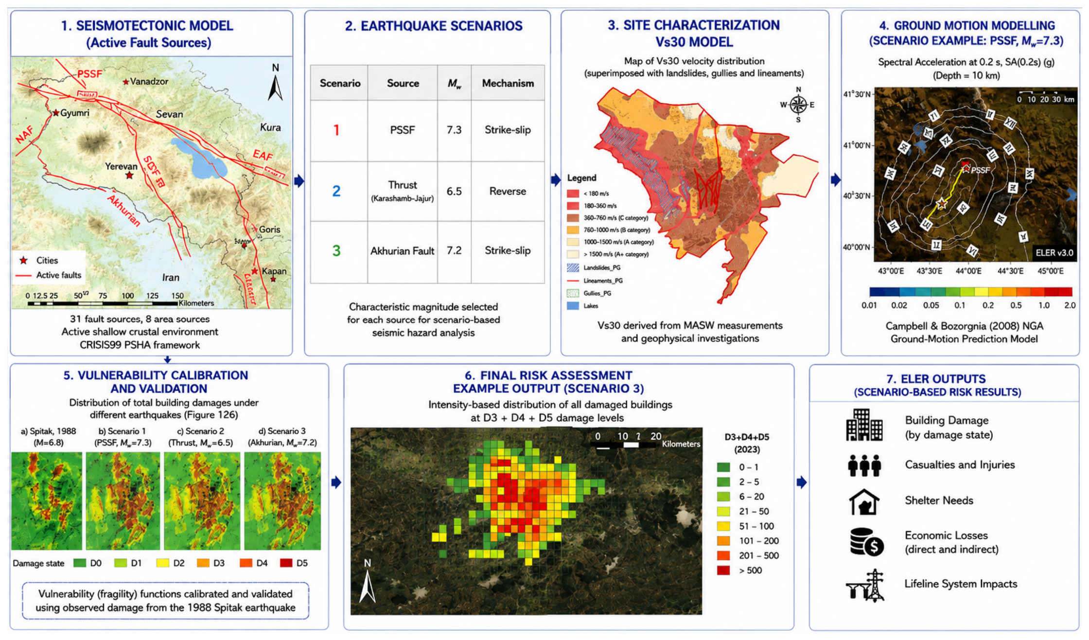
Building vulnerability relationships were calibrated and validated using documented damage observations from the 1988 Spitak earthquake. The calibrated vulnerability functions were then integrated with the hazard and exposure models within the ELER framework to estimate earthquake-induced building damage, casualties, and emergency shelter demand. The overall workflow adopted in this study is presented in
Figure 2.
2.2. Seismotectonic Framework and Earthquake Scenario Selection
Armenia is located within the Arabia–Eurasia continental collision zone, one of the most seismically active regions of the Alpine–Himalayan belt [
3,
22]. Ongoing convergence between the Arabian and Eurasian plates generates active crustal deformation expressed through a network of strike-slip, reverse, and oblique-slip fault systems distributed throughout the Lesser Caucasus [
3,
23]. These tectonic structures have produced numerous destructive historical and instrumental earthquakes, including the 1988 Mw 6.9 Spitak earthquake.
The seismotectonic framework adopted in this study was developed using published geological, seismological, paleoseismological, and tectonic information describing the principal active fault systems of Armenia [
2,
5]. Particular attention was given to fault sources capable of generating significant ground shaking in the investigated urban centers, namely Yerevan, Gyumri, Stepanavan, Kapan, Goris, and Sisian [
24]. The major seismogenic structures considered include the Pambak–Sevan–Syunik Fault System (PSSF), the Garni Fault System (GF), the Akhuryan Fault (AhF), and the Giratagh Fault (GirF) [
5,
6,
7] (
Figure 1).
The characterization of these fault systems considered fault geometry, kinematics, fault-segment length, slip-rate estimates, paleoseismological evidence, historical earthquake records, and instrumental seismicity. Maximum expected magnitudes (Mmax) were evaluated using empirical fault-scaling relationships proposed by Coppersmith (1991) [
25] and Wells and Coppersmith (1994) [
26], together with available geological and paleoseismological constraints. The principal active fault systems used in the scenario-selection process are summarized in
Table 1.
Figure 2.
The framework integrates seismotectonic source characterization, deterministic earthquake scenarios, Vs30-based site characterization, ground-motion modelling, vulnerability calibration using observations from the 1988 Spitak earthquake, and ELER-based earthquake loss estimation [
27].
Figure 2.
The framework integrates seismotectonic source characterization, deterministic earthquake scenarios, Vs30-based site characterization, ground-motion modelling, vulnerability calibration using observations from the 1988 Spitak earthquake, and ELER-based earthquake loss estimation [
27].
The present study adopts a deterministic scenario-based method that evaluates the consequences of representative, physically plausible earthquake scenarios rather than estimating the probability of future earthquake occurrence. Representative earthquake scenarios were selected to evaluate the potential consequences of physically plausible damaging events affecting different regions of Armenia. The selected scenarios correspond to major active fault systems capable of generating strong ground motion within one or more of the investigated cities.
Three representative earthquake scenarios were considered in the analysis (
Table 2). Scenario S1 represents a Mw 7.3 strike-slip earthquake associated with the Pambak–Sevan–Syunik Fault System, one of the most significant active tectonic structures in northern Armenia. Scenario S2 corresponds to a Mw 6.5 reverse-fault event associated with a regional thrust structure affecting central Armenia. Scenario S3 represents a Mw 7.2 strike-slip earthquake occurring on the Akhuryan Fault, which constitutes a major seismic source for northwestern Armenia. Together, these scenarios represent different source mechanisms, magnitudes, and source-to-site configurations and therefore provide a suitable basis for comparative seismic risk assessment.
A hypocentral depth of 10 km was assumed for all scenarios. This depth corresponds to the average focal depth of shallow crustal earthquakes recorded within the Armenian Highland. The selected earthquake scenarios were designed to represent plausible high-impact events associated with the principal seismogenic structures controlling seismic hazard throughout the study area.
Previous seismic hazard assessments and scenario-based studies conducted for Yerevan, Gyumri, Stepanavan, Kapan, Goris, and Sisian indicate that the dominant seismic hazard in these cities is controlled by nearby active fault systems and their associated seismogenic segments [
5,
24]. These regional seismotectonic considerations provided the basis for selecting the representative deterministic earthquake scenarios adopted in this study.
For each scenario, deterministic ground-motion calculations were subsequently performed using the Campbell and Bozorgnia (2008) [
27] ground-motion prediction model integrated within the ELER platform. Site amplification effects were incorporated through the Vs30-based site-classification framework described in the following sections.
Note: Detailed fault-segment parameters, slip-rate estimates, and magnitude calculations used in the scenario-selection process are provided in
Supplementary Table S1.
2.3. Ground Motion Modeling
Ground-motion calculations were performed using the Earthquake Loss Estimation Routine (ELER) platform, which integrates seismic source characterization, attenuation relationships, site conditions, and exposure information within a unified earthquake risk assessment framework.
For each earthquake scenario, deterministic simulations were conducted to estimate the spatial distribution of ground-motion parameters throughout the investigated urban areas. The modeled parameters included peak ground acceleration (PGA), spectral acceleration at periods of 0.2 s and 1.0 s [SA(0.2 s) and SA(1.0 s)], and macroseismic intensity (MSK-64). These parameters constitute the primary inputs for the subsequent vulnerability and loss-estimation analyses.
Ground-motion estimates were calculated using empirical Ground Motion Prediction Equations (GMPEs) developed for active shallow crustal tectonic environments. Owing to the limited availability of locally calibrated GMPEs for Armenia, several internationally recognized models applicable to tectonically comparable regions were reviewed, including Akkar and Bommer (2007) [
28], Campbell and Bozorgnia (2008) [
27], Chiou and Youngs (2008, 2014) [
29,
30,
31], and Boore and Atkinson (2008) [
32].
The Campbell and Bozorgnia (2008) [
27] model was selected because it was developed for active shallow crustal environments and has been widely applied in tectonically complex regions characterized by crustal faulting. In addition, previous seismic hazard studies in Armenia have successfully applied this model, providing consistency with existing regional assessments. More recent NGA-West2 models, including Chiou and Youngs (2014) [
31], were reviewed during the evaluation stage; however, they could not be directly implemented within the current ELER framework. Consequently, the Campbell and Bozorgnia (2008) [
27] model was selected for implementation in the ELER framework because of its applicability to active shallow crustal earthquakes, compatibility with the available software environment, and consistency with previous regional seismic hazard assessments conducted in Armenia.
We acknowledge that no GMPE has yet been specifically calibrated for Armenia due to the limited availability of strong-motion recordings. Therefore, the adopted model should be considered an approximation of regional ground-motion behavior.
Local site effects were incorporated through Vs30-based site characterization derived from geological, geotechnical, and geophysical investigations. Spatially distributed Vs30 models were integrated into the ground-motion calculations to account for amplification effects associated with near-surface geological conditions. Macroseismic intensity distributions were estimated using empirical relationships between instrumental ground-motion parameters and intensity proposed by Wald et al. (1999a,b) [
33,
34].
The resulting hazard outputs were generated as raster-based GIS layers and subsequently integrated with the exposure and vulnerability databases. The principal ground-motion parameters used in the seismic risk assessment are summarized in
Table 3. These products formed the basis for estimating building damage, casualties, emergency shelter demand, and other seismic-risk indicators for each investigated city.
2.4. Site Characterization and Vs30 Mapping
Local site conditions were characterized through an integrated geophysical investigation program conducted in all six study cities. The objective of the surveys was to determine the spatial variability of near-surface dynamic soil properties and to develop site-condition models suitable for seismic hazard and risk assessment.
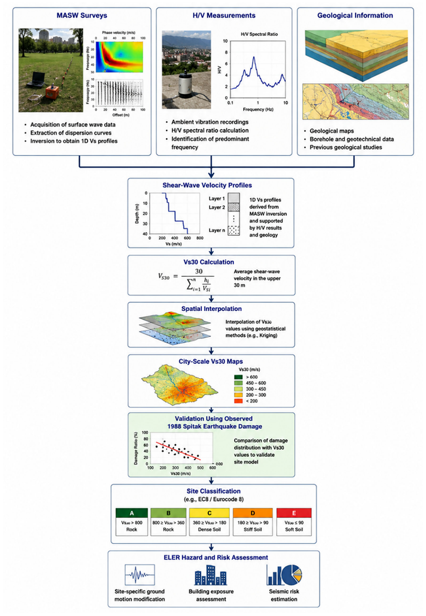
The investigations included Multichannel Analysis of Surface Waves (MASW) and ambient vibration (H/V spectral ratio) measurements. These methods were selected because they provide reliable estimates of shear-wave velocity structure and site resonance characteristics, which are essential for evaluating local site amplification effects during strong ground motion. The overall workflow for geophysical site characterization, Vs30 model development, validation, and integration into the seismic risk assessment framework is illustrated in
Figure 3.
For each city, a network of geophysical measurement points was established to ensure representative spatial coverage of the urban area. MASW measurements were used to derive one-dimensional shear-wave velocity profiles, while H/V measurements were employed to identify predominant site periods and to support the spatial interpolation of dynamic soil properties. The combined interpretation of MASW and H/V data allowed the development of detailed Vs30 maps representing the average shear-wave velocity in the upper 30 m of the soil profile.
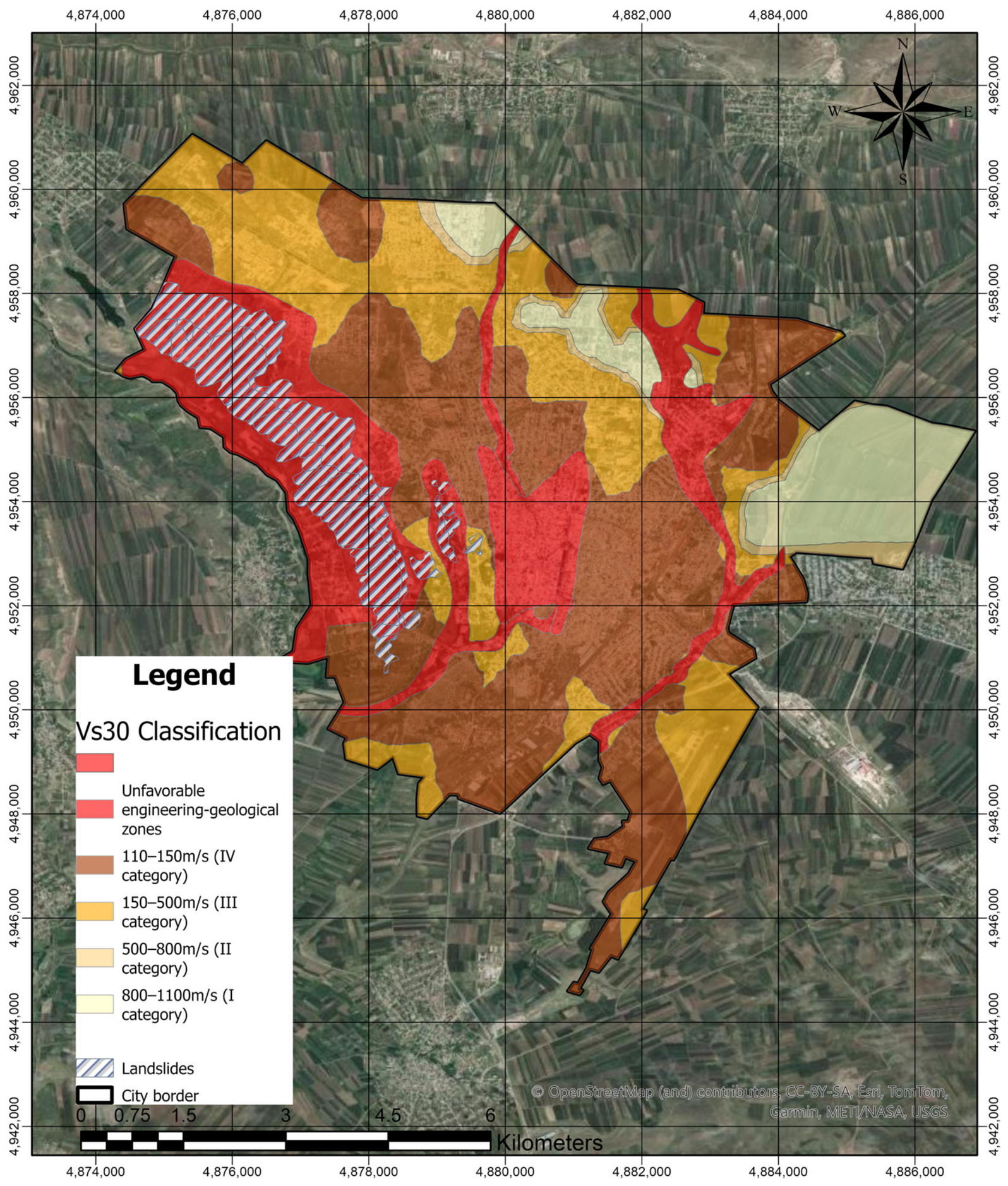
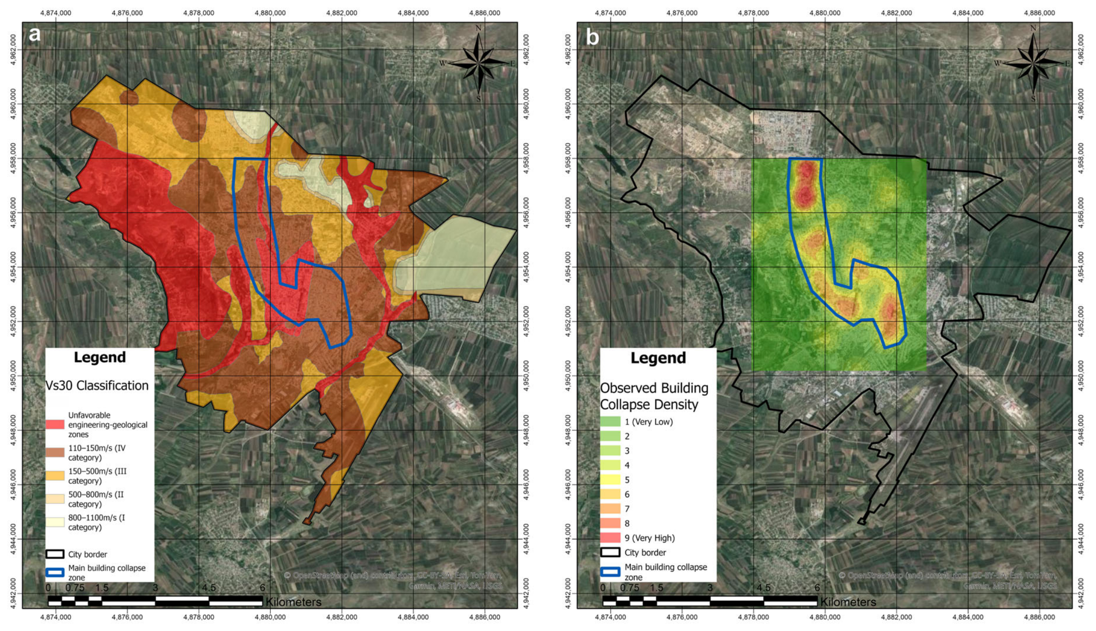
The resulting Vs30 models were integrated into the GIS-based seismic risk assessment framework and used to assign local site-condition parameters to the hazard-calculation grid and exposure database (
Figure 4). Within urban areas, site characterization was based on field-derived Vs30 values obtained from geophysical surveys. Outside the surveyed urban zones, additionalinformation from the USGS Vs30 global Vs30 database was used to ensure continuous spatial coverage of the hazard calculations [
35].
The same Vs30-based site-characterization method was applied consistently to all six investigated cities. However, only Gyumri is presented in detail because it provides the most suitable validation case, owing to the availability of comprehensive geophysical investigations and well-documented post-earthquake damage data from the 1988 Spitak earthquake.
2.4.1. Evaluation of the Vs30-Based Site Characterization Using Observed Damage from the 1988 Spitak Earthquake
Gyumri was selected as the principal validation case because of the availability of detailed post-earthquake damage information from the 1988 Spitak earthquake. A total of 36 MASW profiles and 50 ambient vibration (H/V) measurements were performed to characterize local site conditions and develop a city-scale Vs30 model.
Measured Vs30 values ranged from approximately 150 m/s to 400 m/s, with an average value of about 273 m/s. Most of the investigated urban area corresponds to Site Class C conditions, whereas localized sectors characterized by lower shear-wave velocities were classified as Site Class D. These softer-soil sectors generally coincide with areas expected to experience stronger ground-motion amplification.
The reliability of the developed site-condition model was evaluated through comparison with the observed spatial distribution of earthquake damage caused by the 1988 Spitak earthquake (
Figure 5). Areas characterized by lower Vs30 values generally coincide with zones that experienced more severe building damage and secondary geological effects. The observed agreement between independently derived site-condition parameters and documented earthquake damage provides additional confidence in the applicability of the developed site-characterization framework.
The final Vs30 models were incorporated into the ELER platform and used for site-specific ground-motion modification, allowing the hazard calculations to account for local amplification effects and the spatial variability of near-surface geological conditions.
The final Vs30 models were incorporated into the ELER platform and used for site-specific ground-motion modification, allowing the hazard calculations to account for local amplification effects and the spatial variability of near-surface geological conditions. The observed agreement between the independently derived site-condition model and the spatial distribution of documented earthquake damage provides additional confidence in the applicability of the developed framework for scenario-based seismic risk assessment.
2.4.2. Incorporation of Site Effects
Local site effects were incorporated into the hazard calculations through the assignment of spatially distributed Vs30 values derived from geophysical measurements and site-characterization studies. The resulting Vs30 maps were integrated within the ELER framework to account for variations in soil stiffness and site amplification characteristics across the investigated urban areas.
For each earthquake scenario, ground-motion parameters were calculated using the selected GMPE and subsequently adjusted according to local site conditions. This procedure enabled the generation of site-dependent intensity distributions, peak ground-motion parameters, and spectral acceleration values used in the vulnerability and loss-estimation calculations.
The integration of regionally appropriate ground-motion prediction models with locally derived Vs30 information provides a consistent and physically based framework for the assessment of seismic hazard and earthquake risk in the investigated Armenian cities.
The resulting Vs30 models were incorporated into the ELER platform and assigned to the hazard-calculation grid, allowing scenario-specific ground-motion fields to account for local amplification effects and spatial variations in near-surface geological conditions. This integration provides a physically consistent framework linking geophysical site characterization with deterministic hazard modelling and earthquake loss estimation.
2.5. Development of the GIS-Based Exposure Database
A comprehensive GIS-based exposure database was developed to represent the spatial distribution and characteristics of the built environment, population, and critical infrastructure within the six investigated Armenian cities. The exposure model constitutes a key component of the seismic risk assessment framework, providing the spatial information required for estimating earthquake-induced losses.
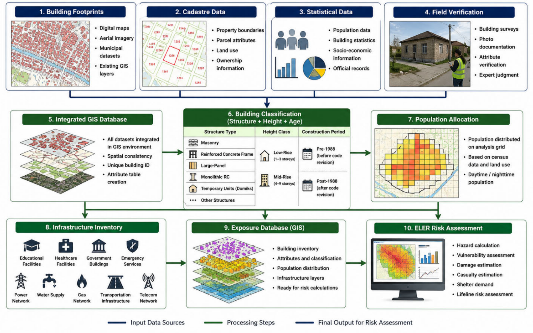
The exposure database was compiled through the integration of multiple information sources, including building footprint maps, cadastral datasets, municipal records, statistical information, census data, and field observations. Building footprints were obtained from available GIS layers and digital maps, while additional information regarding building characteristics was collected from municipal databases, engineering surveys, and previous seismic risk assessment studies conducted in Armenia [
24].
Following data integration, individual buildings were classified according to structural type, building height, and construction period. Particular emphasis was placed on characteristics known to influence seismic performance, including construction material, structural system, number of storeys, and the implementation period of seismic design regulations. The resulting classification scheme was designed to be compatible with the vulnerability models adopted in the subsequent stages of the analysis.
Population exposure was incorporated using available demographic information and spatial allocation procedures. Daytime and nighttime population distributions were associated with the building inventory and the analysis grid, allowing subsequent estimation of casualties, displaced population, and emergency shelter requirements.
In addition to residential structures, the exposure database includes essential facilities and critical infrastructure components such as educational institutions, healthcare facilities, government buildings, emergency services, transportation infrastructure, utility networks, and communication systems. These datasets were incorporated to support the assessment of both direct and indirect earthquake impacts.
The final GIS database was organized as a multilayer spatial inventory integrating buildings, population, and infrastructure information. The resulting exposure model served as the primary input for the vulnerability and loss-estimation modules implemented within the ELER platform. The overall workflow used for the development of the GIS-based exposure database is illustrated in
Figure 6.
2.5.1. Building Taxonomy and Structural Classification
The seismic performance of buildings depends strongly on structural configuration, construction quality, seismic design level, ductility characteristics, and construction period. Consequently, the building inventory was classified using a taxonomy adapted from internationally recognized seismic risk assessment frameworks, including Risk-UE and HAZUS.
The original European building taxonomy distinguishes several masonry and reinforced-concrete structural classes according to construction material, structural system, and earthquake-resistant design level. To ensure applicability to Armenian urban environments, the taxonomy was adapted using local construction practices, engineering expertise, and information derived from previous seismic performance observations.
For masonry buildings, three principal structural classes were identified:
M3—Simple Stone Masonry, consisting of buildings constructed using partially dressed stone blocks arranged according to traditional construction practices;
M6—Unreinforced Masonry with Reinforced Concrete Floors, characterized by masonry walls combined with reinforced concrete floor systems;
M7—Reinforced or Confined Masonry, representing masonry structures incorporating structural measures intended to improve strength, integrity, and ductility.
For reinforced-concrete buildings, two principal classes were considered:
Monolithic reinforced-concrete structures were incorporated into the RC6 category because of their higher expected seismic performance and improved earthquake-resistant detailing. Similarly, frame and large-panel buildings exhibiting adequate structural reinforcement were classified according to their corresponding reinforced-concrete categories.
Temporary residential units (“domiks”), widely constructed after the 1988 Spitak earthquake, were treated as a separate exposure category because of their distinct structural characteristics and occupancy patterns.
The adopted taxonomy therefore considers not only construction material but also structural configuration, earthquake-resistant design level, expected ductility, and structural detailing, all of which are known to significantly influence seismic performance during strong ground shaking. The correspondence between the adopted Armenian building classes and the Risk-UE taxonomy, together with their expected seismic performance, is summarized in
Table 4.
The classification scheme was implemented consistently across all investigated cities, ensuring a consistent basis for the development of the exposure and vulnerability models.
2.5.2. Construction Period and Seismic Design Considerations
Because the 1988 Spitak earthquake fundamentally changed seismic design practice in Armenia, the building inventory was additionally subdivided according to construction period.
Two principal groups were distinguished:
Pre-1988 buildings, designed and constructed before the introduction of modern seismic design requirements;
Post-1988 buildings, constructed following substantial revisions of seismic design regulations and construction practices implemented after the Spitak earthquake.
This distinction was introduced because significant differences in structural detailing, earthquake-resistant design provisions, construction quality, and expected ductility exist between the two building generations. Consequently, buildings with similar structural systems but different construction periods may exhibit substantially different seismic performance.
The final exposure model therefore combines information regarding:
This multi-parameter classification scheme provides a substantially more realistic representation of the urban building stock than classifications based solely on construction material and allows the vulnerability assessment framework to better capture differences in expected earthquake performance among building categories.
2.6. Vulnerability Calibration and Validation
The seismic vulnerability component of the risk-assessment framework was developed using fragility relationships derived from the EMS-98, Risk-UE, HAZUS, and Euro-Mediterranean seismic-risk assessment approaches. To ensure applicability to Armenian urban environments, the vulnerability functions were calibrated using documented damage observations from the 1988 Spitak earthquake.
The calibration process incorporated information regarding observed structural performance, post-earthquake damage statistics, macroseismic intensity distributions, and engineering assessments of representative Armenian building typologies. Particular attention was given to masonry-dominated residential buildings, which constitute a significant proportion of the urban building stock and exhibited considerable damage during the Spitak earthquake.
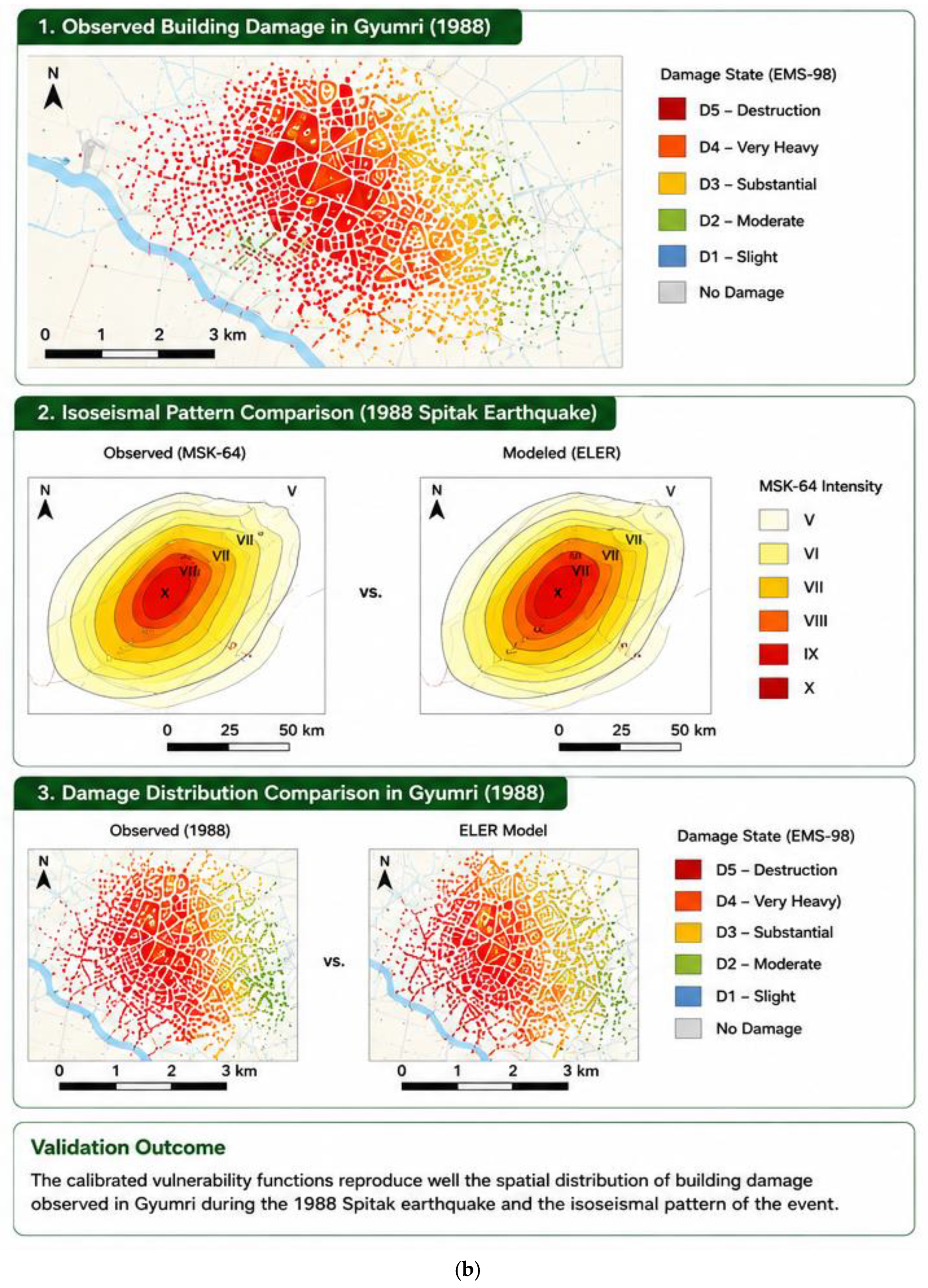
The calibration procedure involved adjustment of vulnerability indices, fragility-function parameters, and damage-state transition thresholds to improve the consistency between modeled and observed building damage patterns. The calibrated model was subsequently evaluated by comparing the spatial distribution and relative concentration of simulated building damage with the documented post-earthquake damage patterns observed after the 1988 Spitak earthquake in Gyumri. The comparison showed satisfactory spatial agreement between the simulated damage concentrations and the documented areas of severe earthquake damage, supporting the applicability of the calibrated vulnerability model for regional seismic risk assessment.
The resulting vulnerability relationships provide a regionally adapted representation of expected building performance under strong ground shaking and form the basis for the subsequent earthquake-loss estimation analyses.
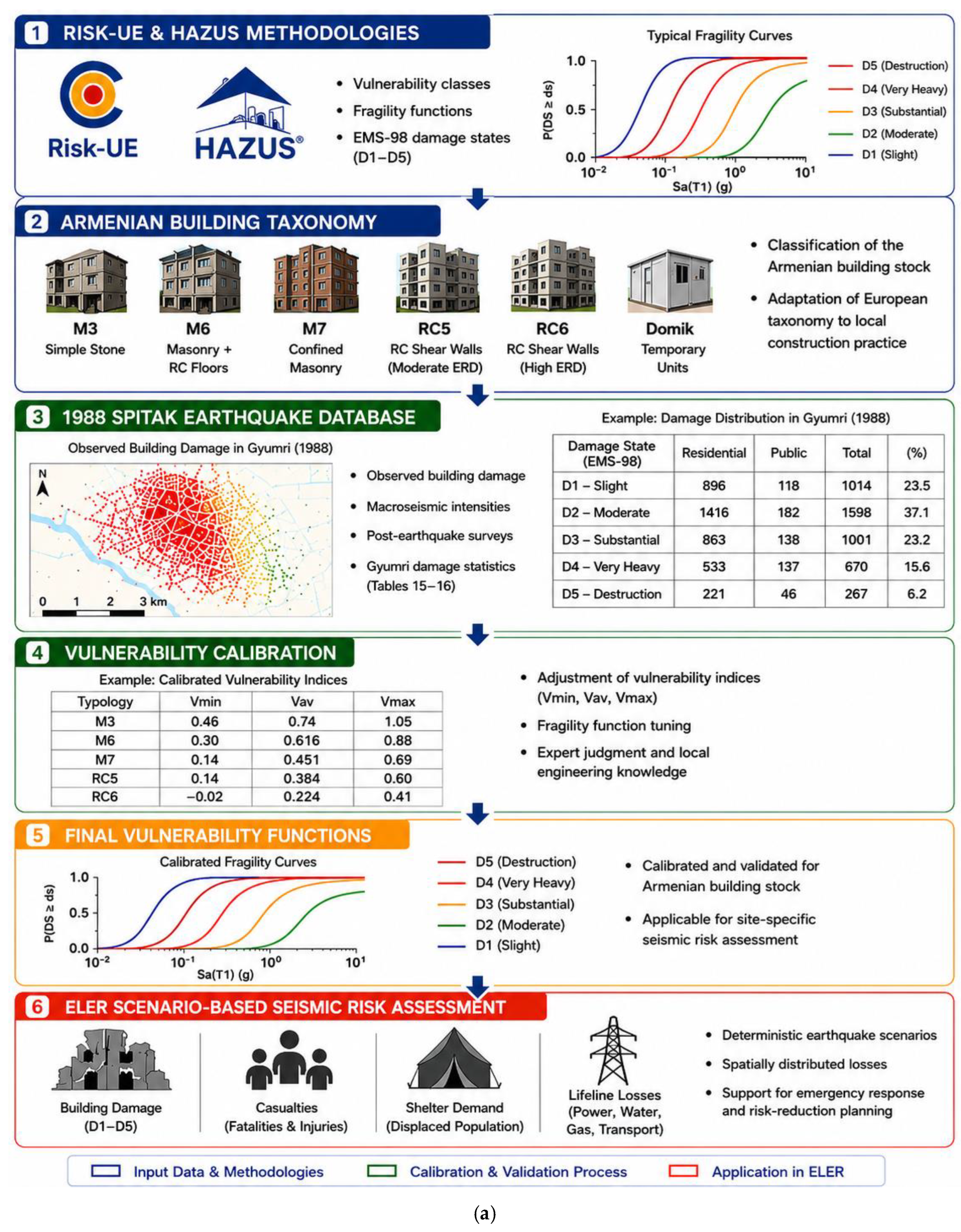
The vulnerability calibration followed a structured sequential workflow integrating internationally established seismic risk assessment methods (Risk-UE and HAZUS), the Armenian building taxonomy, and the observed building damage database compiled after the 1988 Spitak earthquake. Initial vulnerability indices and fragility functions were iteratively adjusted to minimize discrepancies between simulated and observed damage patterns. The calibrated model was subsequently validated through comparison of the spatial distribution of simulated building damage with documented post-earthquake damage observations from Gyumri. The validated vulnerability functions were then implemented within the ELER framework to perform deterministic scenario-based seismic risk assessments for the six investigated cities.
Figure 7a,b summarize the complete vulnerability calibration and validation framework adopted in this study.
Figure 7a illustrates the sequential workflow of vulnerability model development, including the integration of the Armenian building taxonomy, adaptation of the Risk-UE and HAZUS methods, calibration of vulnerability indices and fragility functions using the 1988 Spitak earthquake database, and implementation of the calibrated vulnerability model within the ELER seismic risk assessment framework.
Figure 7b presents the validation procedure through comparison of observed and simulated building damage distributions and isoseismal patterns for the 1988 Spitak earthquake, demonstrating the consistency of the calibrated model with documented earthquake observations.
2.6.1. Fragility Functions
Fragility functions describe the probability of exceeding specified damage states as a function of earthquake ground-motion intensity. In the present study, fragility relationships were assigned to each structural typology based on the calibrated vulnerability framework described above.
The initial fragility relationships were adopted from the Risk-UE and HAZUS meth methods and subsequently adapted to the Armenian building taxonomy. Calibration was performed through iterative adjustment of the vulnerability indices together with the median intensity thresholds and dispersion parameters of the fragility functions using the documented building damage from the 1988 Spitak earthquake as the principal observational reference. The calibration process aimed to improve the agreement between the simulated damage-state distributions and the documented spatial distribution of earthquake damage. The resulting calibrated fragility functions were subsequently implemented in the ELER framework for the deterministic scenario-based seismic risk assessment.
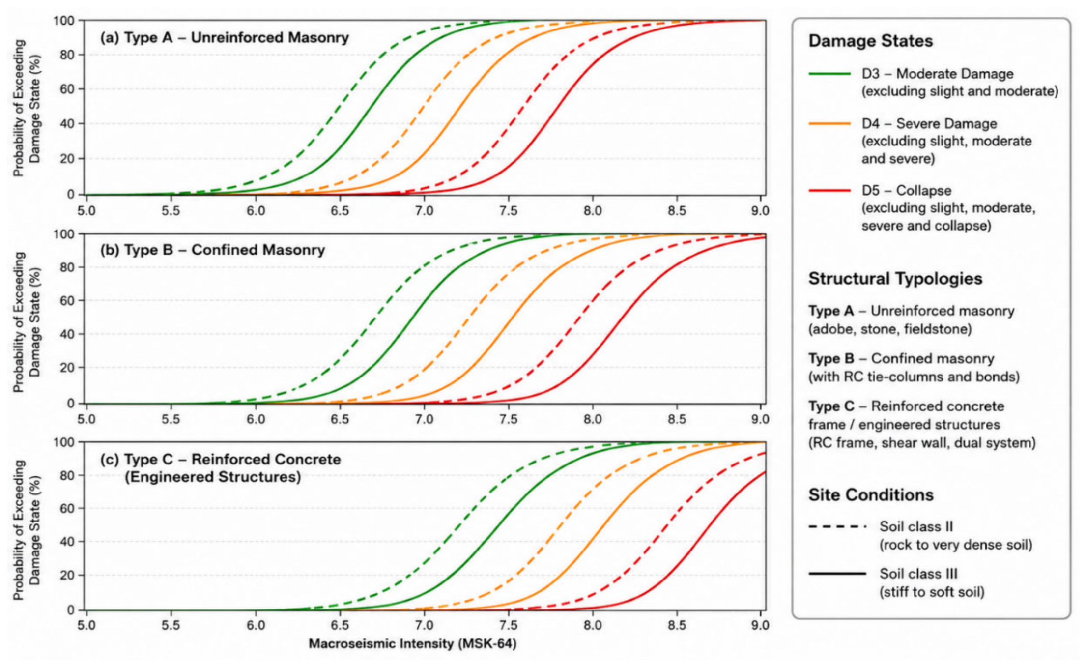
The adopted fragility curves represent the probabilities of exceeding moderate (D3), severe (D4), and complete/collapse (D5) damage states under increasing macroseismic intensity levels. Separate functions were assigned to masonry and reinforced-concrete building classes to reflect their differing seismic performance characteristics.
The calibrated fragility relationships demonstrate the substantially higher vulnerability of unreinforced masonry structures compared with engineered reinforced-concrete systems. Site-condition effects were incorporated through the consideration of different soil classes, thereby accounting for variations in local ground-motion amplification. The final calibrated fragility functions for the representative Armenian structural typologies and different site conditions are presented in
Figure 8.
2.6.2. Calibration and Validation Using the 1988 Spitak Earthquake
Although Risk-UE and HAZUS provide standardized vulnerability relationships for a wide range of building classes, direct application of generic vulnerability functions may not adequately represent regional construction practices and historical seismic performance.
To improve the reliability of the risk estimates, the vulnerability framework was adapted to the dominant building typologies identified in each of the six investigated cities. The composition of the residential building stock varies considerably among the study areas. In Yerevan, masonry buildings dominate the inventory, comprising 57.9% simple stone masonry (M3), 24.8% unreinforced masonry with reinforced-concrete floors (M6), and 10.4% reinforced/confined masonry (M7), whereas reinforced-concrete buildings account for approximately 2.0% of the inventory. Gyumri exhibits a distinctly different composition, with reinforced/confined masonry representing 43.3% of the residential stock, simple stone masonry 21.5%, temporary residential units (“domiks”) 30.8%, and reinforced-concrete buildings approximately 2.7%.
In Stepanavan, the building stock is overwhelmingly dominated by simple stone masonry buildings (95.8%), while reinforced/confined masonry, reinforced-concrete, large-panel, and wooden structures collectively account for less than 5% of the inventory. Kapan is characterized by 86.2% simple stone masonry buildings and 13.4% reinforced/confined masonry buildings. Similarly, Goris and Sisian are dominated by simple stone masonry structures, accounting for 95.5% of the residential building stock in both cities, whereas reinforced/confined masonry buildings comprise 4.5% and 4.1%, respectively. Accordingly, vulnerability functions were assigned to these dominant structural classes because they constitute the vast majority of the residential building stock in the six study cities.
The adopted vulnerability classes, primarily derived from the Risk-UE method and subsequently adapted to the Armenian building taxonomy and local construction practice, therefore reflect both internationally recognized seismic vulnerability concepts and local engineering knowledge regarding the structural characteristics and expected earthquake performance of Armenian buildings.
The calibration and validation of the vulnerability model were performed using the observed damage caused by the 7 December 1988 Spitak earthquake, which remains the most destructive earthquake recorded in modern Armenian history.
The city of Gyumri was selected as the principal calibration area because detailed post-earthquake damage information is available for both residential and public buildings [
7,
11]. Observed damage distributions, building typologies, macroseismic intensities, and documented loss statistics were analyzed and compared with the results obtained from the ELER vulnerability framework.
The calibration process was performed by comparing simulated damage distributions with documented post-earthquake damage statistics available for Gyumri. Vulnerability indices and fragility parameters were iteratively adjusted until the simulated proportions of moderate, extensive, and complete damage showed satisfactory agreement with observed earthquake losses. Particular emphasis was placed on reproducing the damage patterns of pre-1988 masonry buildings, which constituted the most vulnerable component of the urban building stock during the Spitak earthquake.
Standard vulnerability relationships derived from the literature were initially assigned to the Armenian building classes. Subsequently, the vulnerability parameters were adjusted through an iterative calibration process to improve agreement between simulated and observed damage distributions. Particular emphasis was placed on reproducing the spatial distribution of heavily damaged and collapsed buildings as documented after the Spitak earthquake.
The calibration procedure incorporated information regarding:
observed building damage patterns;
construction period;
structural typology;
local site conditions;
macroseismic intensity distribution;
post-earthquake engineering observations.
The resulting vulnerability model therefore reflects both international vulnerability methods and empirical evidence obtained from the most significant historical earthquake affecting Armenia.
The calibrated vulnerability model was subsequently evaluated by comparing the simulated building damage with the documented damage statistics of the 1988 Spitak earthquake. The comparison showed satisfactory agreement in both the overall distribution of damage and its spatial pattern within Gyumri, indicating that the calibrated vulnerability functions provide realistic estimates of heavily damaged and collapsed buildings.
This calibration-based evaluation increased confidence in the applicability of the adapted vulnerability functions for deterministic seismic risk assessment in Armenia. Consequently, these calibrated functions were adopted for all subsequent scenario-based analyses presented in this study.
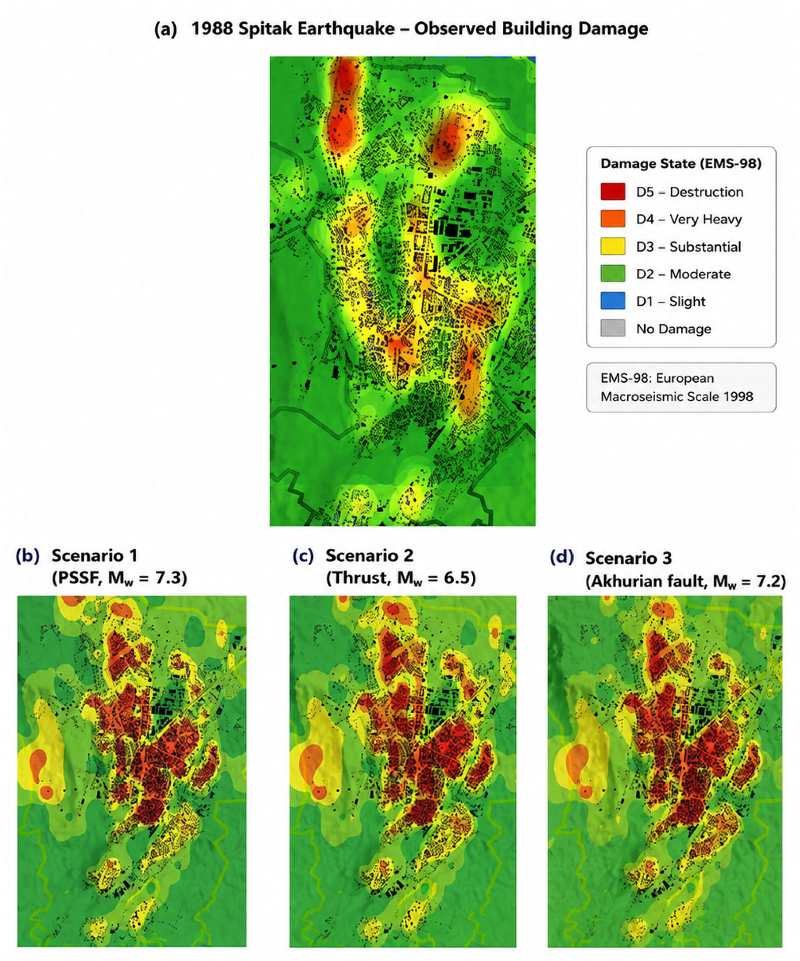
Figure 9 illustrates the distinction between the empirical calibration dataset and the deterministic earthquake scenarios adopted in this study.
Figure 9a presents the observed building damage distribution following the 1988 Spitak earthquake, which was used exclusively for calibration and validation of the vulnerability model.
Figure 9b–d present simulated damage distributions obtained for three independent deterministic earthquake scenarios selected for the subsequent regional seismic risk assessment. These scenario earthquakes were not intended to reproduce the 1988 Spitak earthquake but rather to represent physically plausible future earthquake events affecting the investigated region.
2.7. Earthquake Loss Estimation Within ELER
Damage and earthquake-loss estimation were performed using the ELER (Earthquake Loss Estimation Routine) platform, which integrates hazard parameters, exposure datasets, occupancy information, and vulnerability functions within a GIS-based earthquake loss-estimation workflow.
The adopted method enables estimation of the spatial distribution of building damage, expected casualties, displaced population, emergency shelter demand, and selected impacts on critical infrastructure associated with the investigated earthquake scenarios.
Building damage was estimated according to the EMS-98 damage-state framework, including slight (D1), moderate (D2), substantial (D3), severe (D4), and complete/collapse (D5) damage levels. Casualty estimation was based on empirical relationships linking structural damage states to injury and fatality rates under residential occupancy conditions.
The resulting loss estimates were generated as GIS-based spatial products and subsequently analyzed to identify the most vulnerable sectors of each investigated city. These products form the basis for the comparative evaluation of earthquake impacts presented in the following sections.
2.8. Uncertainty Considerations
The results presented in this study are subject to uncertainties associated with earthquake source characterization, ground-motion prediction equations (GMPEs), local site conditions, exposure datasets, and vulnerability relationships. Additional uncertainty arises from limitations in available building inventory information, spatial variability in construction quality, and assumptions regarding building occupancy during earthquake events.
Uncertainty in the hazard component is primarily related to the definition of deterministic earthquake scenarios, fault geometry, rupture characteristics, and the selection of the Campbell and Bozorgnia (2008) [
27] ground-motion prediction model. Although this GMPE has been previously applied in seismic hazard studies in Armenia and is fully implemented within the ELER framework, alternative attenuation models may produce different estimates of shaking intensity and spatial distribution of earthquake effects.
Additional uncertainty is associated with the representation of local site conditions. While extensive MASW and H/V investigations were conducted in the study areas, the resulting Vs30 models remain simplified representations of complex subsurface conditions and may not fully capture all aspects of site response during strong ground shaking.
The exposure and vulnerability components also contribute to overall uncertainty. Building inventories compiled from multiple sources may contain incomplete or generalized information regarding structural characteristics, occupancy, and construction quality. Similarly, although the vulnerability functions were calibrated and validated using observations from the 1988 Spitak earthquake, regional variability in building performance and structural detailing cannot be fully represented.
Despite these limitations, the adopted method provides a consistent and regionally applicable framework for comparative evaluation of earthquake impacts across major Armenian cities. The results should therefore be interpreted as scenario-based estimates of relative seismic risk and urban vulnerability rather than exact predictions of future earthquake losses.
3. Results
3.1. Ground Motion Distribution
Deterministic ground-motion simulations were performed for the representative earthquake scenarios defined for the six investigated Armenian cities: Yerevan, Gyumri, Stepanavan, Kapan, Goris, and Sisian. The selected scenarios correspond to the principal active fault systems controlling regional seismic hazard and represent physically plausible high-impact earthquake events with magnitudes ranging from Mw 6.5 to Mw 7.3.
For each scenario, spatial distributions of peak ground acceleration (PGA), spectral acceleration, and macroseismic intensity were calculated using the Campbell and Bozorgnia (2008) [
27] NGA ground-motion prediction model implemented within the ELER platform. Site-specific amplification effects were incorporated through the Vs30-based site-characterization framework described in
Section 2.4.
The modeled ground-motion fields reveal substantial spatial variability associated with fault geometry, source-to-site distance, attenuation effects, topographic conditions, and local geological characteristics. The highest shaking intensities are concentrated in areas located closest to the causative fault structures, whereas ground-motion amplitudes decrease progressively with increasing distance from the source.
The influence of local site conditions is particularly evident within urban environments characterized by soft-soil deposits and lower Vs30 values, where amplified ground-motion levels are observed relative to surrounding areas. These amplification effects contribute significantly to the spatial heterogeneity of the hazard distribution and play an important role in controlling the subsequent distribution of earthquake damage.
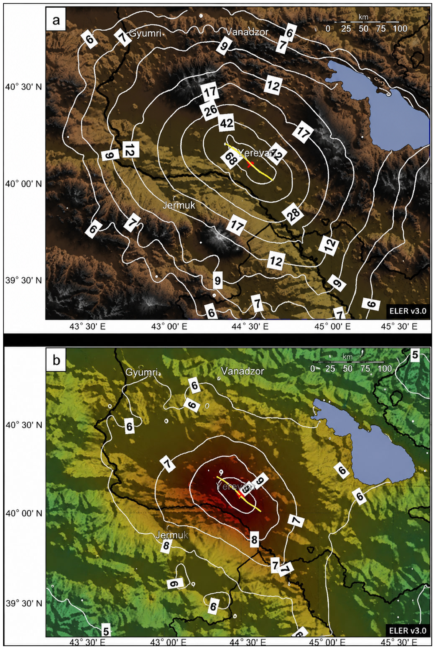
Figure 10 presents an example of the modeled spatial distribution of peak ground acceleration (PGA) and macroseismic intensity for a representative deterministic earthquake scenario. The results demonstrate the combined influence of regional seismotectonic setting and local site conditions on the expected distribution of seismic shaking throughout Armenia.
Overall, the calculated ground-motion fields provide the hazard input required for the subsequent assessment of building damage, casualties, emergency shelter demand, and other earthquake-loss indicators within the investigated cities.
3.2. Building Damage Assessment
Building damage was estimated within the ELER framework by combining deterministic ground-motion simulations, the GIS-based exposure database, and the calibrated vulnerability functions described in
Section 2.6. Damage was evaluated using the EMS-98 damage-state classification, ranging from slight damage (D1) to complete destruction (D5).
The results indicate substantial spatial variability in expected earthquake damage among the investigated Armenian cities. The distribution of damage is controlled by the combined influence of seismic hazard intensity, local site conditions, building vulnerability, and exposure concentration. Areas characterized by high population density, large building inventories, and vulnerable masonry-dominated structures generally exhibit the highest levels of expected damage.
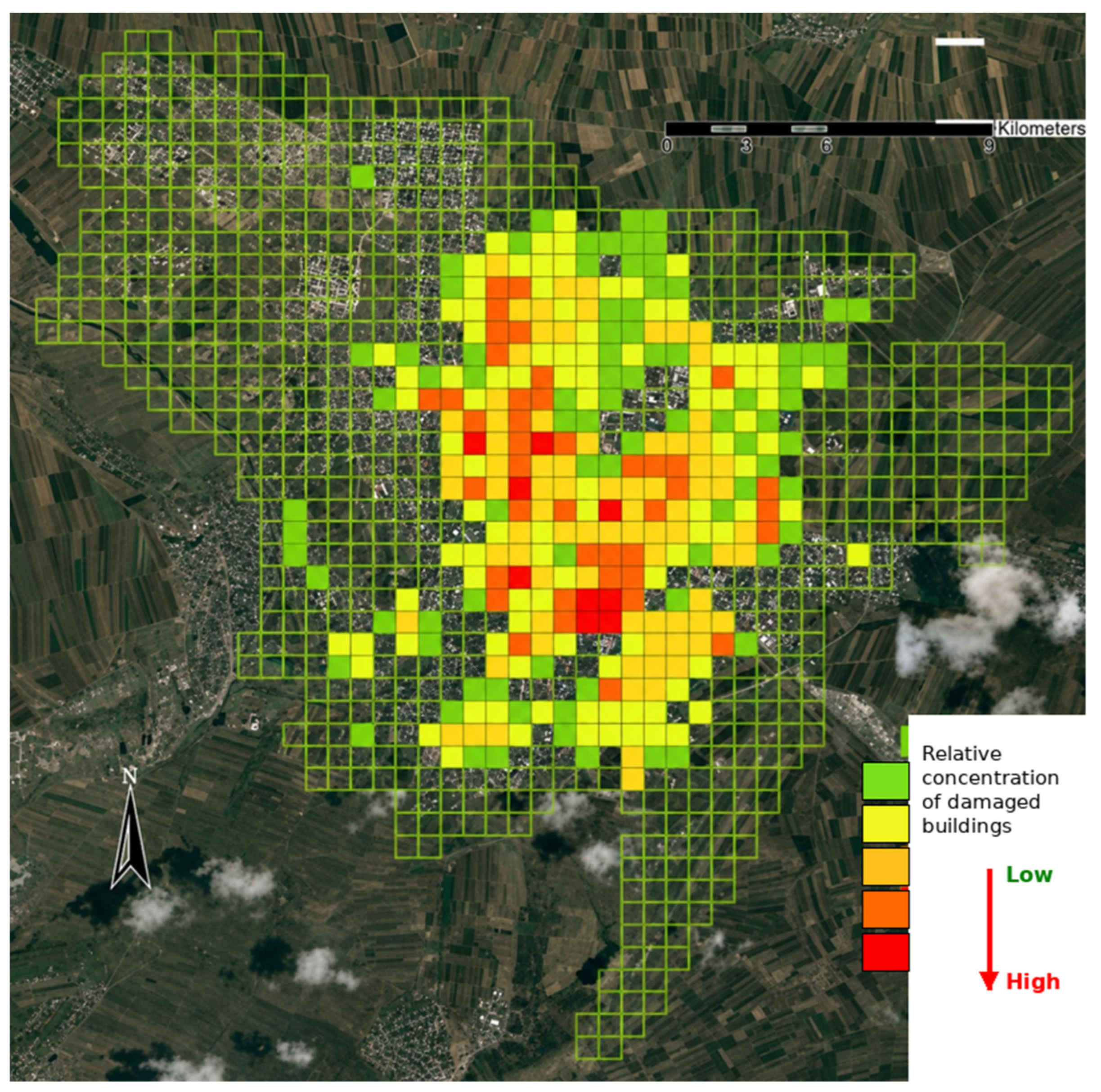
Figure 11 presents an example of the modeled spatial distribution of damaged buildings for the Gyumri urban area. The results demonstrate that severe and very severe damage is concentrated within specific sectors where strong ground shaking coincides with vulnerable building stock and unfavorable site conditions. Similar spatial clustering of damage was observed in the other investigated cities.
The modeled damage patterns are consistent with the general distribution of vulnerability identified through the site-characterization and exposure analyses. In particular, districts characterized by lower Vs30 values and a predominance of older masonry structures exhibit significantly higher proportions of severe damage states (D3–D5) compared with areas dominated by engineered reinforced-concrete buildings and more favorable geological conditions.
Among the investigated cities, Yerevan exhibits the largest absolute number of damaged buildings because of its extensive urban area, high population density, and large building inventory. Gyumri and Stepanavan show elevated relative damage levels due to the combination of high seismic hazard and the presence of vulnerable pre-1988 building stock. Significant damage is also observed in Sisian and Kapan, reflecting their proximity to active fault systems and the characteristics of the local building inventory.
The obtained results indicate that severe damage (D3), very severe damage (D4), and collapse (D5) may affect substantial portions of the building stock under the considered earthquake scenarios. Consequently, structural damage represents one of the principal contributors to the overall seismic risk of Armenian urban environments and forms the basis for subsequent casualty and shelter-demand estimations.
Comparative Building Damage Among the Investigated Cities
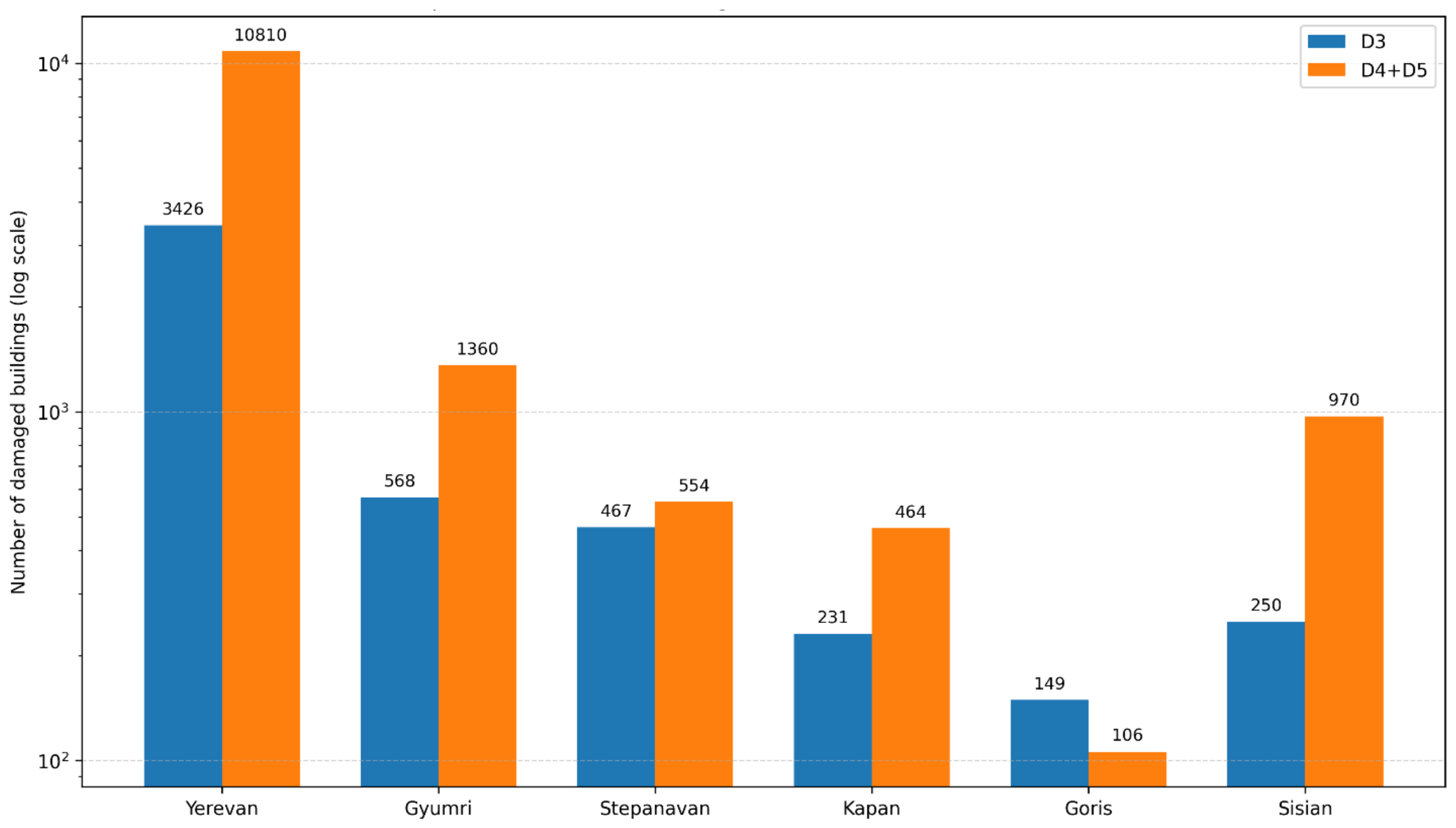
The comparative analysis of earthquake damage reveals significant differences in the expected impact among the six investigated Armenian cities (
Figure 12). These differences primarily reflect variations in exposure concentration, building-stock characteristics, local site conditions, and proximity to major active fault systems.
Casualty estimation was performed using empirical relationships developed within the Coburn and Spence (1992) [
36], KOERI (2002) [
37], and Risk-UE methods, which relate structural damage states to injury and fatality probabilities under earthquake conditions.
Figure 12 summarizes the estimated numbers of seriously injured individuals and fatalities for representative earthquake scenarios affecting Yerevan, Gyumri, and Stepanavan. The results highlight the combined influence of seismic hazard intensity, structural vulnerability, and urban population exposure on earthquake-induced human losses.
The results indicate that Yerevan exhibits the highest absolute losses among all investigated cities. The modeled number of buildings affected by severe and collapse-level damage (D4–D5) exceeds 10,800 buildings, while approximately 3400 buildings are expected to experience substantial damage (D3). These values primarily reflect the large building inventory, high population density, and concentration of urban assets within the capital city.
Gyumri represents the second most vulnerable urban area, with approximately 1360 buildings reaching severe or collapse damage states and about 570 buildings affected by substantial damage. The elevated vulnerability of Gyumri is associated with the presence of extensive masonry-dominated residential districts, local site-amplification effects, and its location within one of the most seismically active regions of Armenia.
Stepanavan exhibits a comparable level of structural vulnerability, with approximately 550 buildings reaching D4–D5 damage states and about 470 buildings affected by D3 damage. The relatively high proportion of damaged buildings reflects both the regional seismic hazard and the characteristics of the local building stock.
Among the southern Armenian cities, Sisian demonstrates the highest expected losses, with nearly 970 buildings reaching severe or collapse damage states. In comparison, Kapan is characterized by approximately 460 severely damaged buildings, while Goris exhibits the lowest level of severe structural damage among the investigated cities, with approximately 100 buildings reaching D4–D5 damage states.
Although the absolute number of damaged buildings is strongly controlled by urban size and exposure concentration, the results also emphasize the importance of local vulnerability characteristics. Several smaller cities exhibit relatively high damage levels despite their substantially smaller building inventories, indicating that local site conditions and building vulnerability may play a role comparable to seismic hazard intensity itself.
Overall, the comparative analysis demonstrates that earthquake risk in Armenia is not controlled solely by earthquake magnitude or distance from the seismic source. Instead, the observed variability results from the combined influence of hazard, exposure, and vulnerability factors, which differ substantially among the investigated urban environments.
3.3. Shelter Demand and Human Impact Assessment
In addition to structural damage, earthquake scenarios were evaluated in terms of their potential consequences for the exposed population. One of the most important indicators for emergency-response planning is the estimated number of people requiring temporary accommodation following severe building damage and collapse.
Within the ELER framework, emergency shelter demand was estimated based on the number of buildings reaching severe (D4) and collapse (D5) damage states, combined with occupancy assumptions and post-earthquake habitability criteria. Buildings classified within these damage states were considered unsuitable for continued occupation, resulting in the temporary displacement of residents.
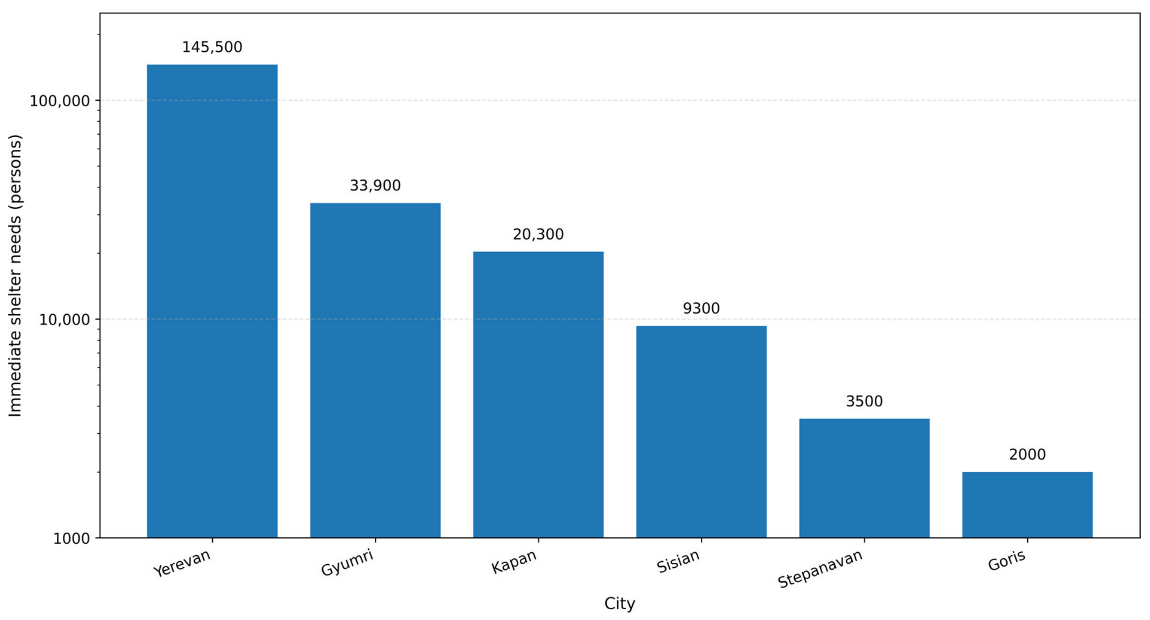
The results indicate substantial differences in expected shelter demand among the investigated Armenian cities (
Figure 13). The largest consequences were estimated for Yerevan, where the combination of high population density and extensive urban exposure produces the greatest displacement potential. Depending on the considered earthquake scenario, the estimated number of people requiring temporary shelter ranges from approximately 69,800 to 145,500 persons.
Among the secondary urban centers, Gyumri exhibits the highest estimated shelter demand, with approximately 33,900 displaced persons under the Mw 7.2 Akhuryan fault scenario. Significant shelter requirements were also estimated for Kapan (20,300 persons) and Sisian (9300 persons), reflecting the influence of nearby active fault systems and the vulnerability of the local building stock. Lower but still substantial shelter demands were estimated for Stepanavan (3500 persons) and Goris (2000 persons).
The results demonstrate that human impacts are controlled not only by seismic hazard intensity but also by the spatial distribution of population and the concentration of vulnerable residential buildings. Consequently, cities characterized by moderate levels of structural damage may still experience significant displacement if the affected areas contain densely populated residential districts.
The estimated shelter-demand values provide important information for emergency preparedness and disaster-response planning. The results may support the identification of priority areas for temporary accommodation, humanitarian assistance, emergency logistics, and post-disaster recovery planning. They also highlight the need for city-specific contingency plans, particularly in Yerevan and Gyumri, where large-scale population displacement could place considerable pressure on available emergency-response resources.
4. Discussion
4.1. Influence of Site Conditions on Earthquake Damage
The obtained results demonstrate that local site conditions constitute one of the principal factors controlling the spatial distribution of earthquake damage in Armenian urban environments. Although earthquake magnitude and source-to-site distance strongly influence regional ground-motion levels, significant variations in expected damage are observed within individual cities because of differences in near-surface geological conditions and associated site-amplification effects.
The developed Vs30 models indicate substantial spatial heterogeneity of soil conditions across the investigated urban areas. Lower Vs30 values generally correspond to softer soil deposits that are more susceptible to seismic-wave amplification, whereas higher Vs30 values are associated with stiffer geological materials and reduced amplification potential. Consequently, districts characterized by lower shear-wave velocities tend to experience higher modeled ground-motion intensities and increased structural damage.
The influence of site conditions is particularly evident in Gyumri, where detailed geophysical investigations and post-earthquake observations provide an opportunity for independent validation. Comparison between the developed Vs30-based site-condition model and the observed distribution of damage from the 1988 Spitak earthquake revealed a clear spatial correspondence between low-Vs30 sectors and areas affected by severe structural damage. This agreement supports the applicability of the adopted site-characterization method and confirms the importance of local geological conditions in controlling earthquake impacts.
The results further indicate that site effects may significantly modify the distribution of earthquake losses even within cities exposed to similar regional hazard levels. Areas located on soft alluvial deposits, weathered volcanic materials, or heterogeneous sedimentary sequences generally exhibit stronger amplification effects than districts underlain by competent bedrock. Consequently, local site conditions contribute to the concentration of damage within specific urban sectors and may partially explain observed differences in earthquake performance among neighboring districts.
Post-earthquake investigations following the 2023 Kahramanmaraş earthquake sequence in Türkiye further highlighted the critical role of local geological conditions, basin effects, and site amplification phenomena in controlling the spatial distribution of ground shaking and structural damage. Similar observations were reported in several heavily affected urban areas, where local site effects contributed to significant variations in damage patterns despite comparable levels of regional seismic hazard. These findings reinforce the importance of incorporating site-specific characterization, including Vs30-based assessments, into urban seismic risk analyses [
38].
The incorporation of field-derived Vs30 models into the ELER framework therefore represents an important improvement compared with approaches based solely on regional hazard characterization. By integrating geophysical measurements directly into the seismic-risk assessment workflow, the analysis captures local-scale variations in ground-motion amplification and provides a more realistic representation of expected earthquake impacts.
Overall, the results highlight the importance of detailed site characterization for urban seismic-risk assessment in Armenia. The observed consistency between geophysical site-condition models and historical earthquake damage patterns suggests that Vs30-based methods provide a reliable basis for identifying zones of elevated seismic hazard and prioritizing future risk-reduction measures.
4.2. Influence of Building Vulnerability and Exposure
In addition to seismic hazard and local site conditions, the results demonstrate that building vulnerability and exposure concentration play a fundamental role in determining earthquake losses across Armenian cities. The comparative analysis indicates that similar levels of ground shaking may produce substantially different consequences depending on the characteristics of the affected building stock and the spatial distribution of exposed assets.
The Armenian urban environment is characterized by a heterogeneous building inventory comprising masonry, reinforced-concrete, large-panel, and temporary residential structures constructed under different generations of seismic design regulations. Consequently, considerable variability exists in the expected seismic performance of individual building classes. The vulnerability assessment performed in this study indicates that masonry-dominated structures, particularly those constructed prior to the 1988 Spitak earthquake, remain among the most vulnerable components of the urban building stock.
The calibration of vulnerability functions using documented damage observations from the 1988 Spitak earthquake confirmed the elevated susceptibility of traditional masonry buildings to severe and collapse-level damage. In contrast, reinforced-concrete structures designed according to more recent seismic standards generally exhibit improved performance and lower probabilities of reaching severe damage states under comparable shaking intensities.
The results also emphasize the importance of exposure concentration. Yerevan consistently exhibits the highest absolute losses among the investigated cities, not necessarily because of the highest hazard levels, but because of its large population, extensive building inventory, and concentration of economic and social assets. Even moderate increases in damage ratios therefore translate into large absolute numbers of damaged buildings and displaced residents.
Recent observations from the 2023 Kahramanmaraş earthquake sequence in Türkiye demonstrated that building vulnerability, construction quality, and compliance with seismic design provisions may exert a stronger influence on earthquake losses than ground-motion intensity alone, particularly in densely populated urban environments. The extensive damage observed in vulnerable building stocks emphasized the importance of accurate vulnerability characterization and regionally calibrated fragility relationships for reliable seismic risk assessment [
39]. These findings are consistent with the results of the present study, which indicate that differences in building vulnerability can substantially modify earthquake consequences even under comparable levels of seismic hazard.
In contrast, cities such as Gyumri and Stepanavan exhibit comparatively smaller exposure inventories but higher relative vulnerability. The combination of strong expected ground motion, vulnerable masonry-dominated residential districts, and locally amplified site conditions results in elevated proportions of severe and collapse-level damage. This observation demonstrates that relative seismic risk is not always directly correlated with urban size or population density.
The southern Armenian cities of Kapan, Goris, and Sisian provide additional evidence of the combined influence of vulnerability and exposure. Although these cities are characterized by smaller populations and building inventories than Yerevan, significant earthquake impacts are still estimated because of their proximity to active fault systems and the presence of vulnerable building categories within the urban fabric.
Overall, the results demonstrate that seismic risk in Armenian cities is controlled by the interaction of hazard, vulnerability, and exposure rather than by any single factor alone. Effective risk-reduction strategies should therefore combine improvements in seismic design and retrofitting practices with detailed urban exposure management and targeted strengthening of the most vulnerable building categories.
4.3. Comparative Seismic Risk Among Armenian Cities
The comparative assessment conducted in this study demonstrates substantial variability in seismic risk among the investigated Armenian cities. Although all six urban centers are exposed to potentially damaging earthquakes generated by nearby active fault systems, the expected consequences differ significantly because of variations in hazard intensity, local site conditions, building vulnerability, and exposure concentration.
Among the investigated cities, Yerevan exhibits the highest absolute earthquake losses. The capital city is characterized by the largest population, the most extensive building inventory, and the highest concentration of economic and social assets. Consequently, even moderate levels of structural damage translate into large absolute numbers of damaged buildings, displaced residents, and emergency-response requirements. The shelter-demand estimates further emphasize the dominant influence of exposure concentration on the overall seismic-risk profile of Yerevan.
In contrast, Gyumri and Stepanavan exhibit some of the highest relative levels of vulnerability. Both cities are located within regions strongly influenced by active fault systems capable of generating severe ground shaking. In addition, significant portions of their building stock consist of masonry-dominated residential structures that demonstrate increased susceptibility to earthquake damage. The combination of elevated hazard levels, vulnerable construction, and locally amplified site conditions contributes to a disproportionately high proportion of severe and collapse-level damage.
The southern Armenian cities of Kapan, Goris, and Sisian present a different risk profile. Although their total exposure is considerably smaller than that of Yerevan, their proximity to active fault systems and locally variable geological conditions result in significant expected earthquake impacts. In particular, Sisian exhibits comparatively high damage levels relative to its urban size, highlighting the importance of considering local hazard characteristics in regional seismic-risk assessments.
The comparative results indicate that no single factor alone controls earthquake risk. Cities characterized by large exposure inventories may experience the greatest absolute losses, whereas smaller urban centers may exhibit higher relative vulnerability because of unfavorable site conditions and vulnerable building stock. This distinction is particularly important for emergency planning because the cities requiring the largest response resources are not necessarily those with the highest relative damage ratios.
The findings further demonstrate the value of applying a unified framework across multiple cities. By combining deterministic earthquake scenarios, site-specific hazard characterization, exposure modeling, and calibrated vulnerability functions within a common assessment framework, the study provides a consistent basis for comparing earthquake consequences throughout Armenia.
Overall, the results highlight the need for city-specific seismic-risk reduction strategies. While Yerevan requires measures focused on reducing large-scale urban losses and improving emergency-response capacity, cities such as Gyumri and Stepanavan may benefit particularly from targeted strengthening of vulnerable building stock and continued implementation of seismic-retrofitting programs.
4.4. Method Limitations and Future Improvements
Although the adopted method provides a comprehensive framework for comparative seismic-risk assessment, several limitations should be considered when interpreting the results.
The hazard component of the analysis is influenced by uncertainties associated with earthquake source characterization, fault geometry, rupture parameters, and the selection of ground-motion prediction equations (GMPEs). In the present study, the Campbell and Bozorgnia (2008) [
27] NGA model was adopted because it is fully implemented within the ELER platform and has previously been applied in seismic hazard studies conducted in Armenia. More recent NGA-West2 models, including Chiou and Youngs (2014) [
31], were evaluated during the method review process; however, they could not be directly implemented within the current ELER framework. Future developments of the platform may enable incorporation of newer generation attenuation models and facilitate additional sensitivity analyses.
Additional uncertainty is associated with the representation of local site conditions. Although extensive MASW and H/V investigations were conducted and spatially distributed Vs30 models were developed for all investigated cities, the resulting site-condition maps remain simplified representations of complex subsurface geological conditions. Local variations in stratigraphy, basin effects, and nonlinear soil behavior during strong ground shaking may not be fully captured by the adopted approach.
The exposure database also introduces uncertainty. Building inventories were compiled from multiple sources, including cadastral datasets, municipal records, statistical information, and field observations. Consequently, variations in data completeness, building classification accuracy, occupancy estimates, and infrastructure inventories may influence the resulting loss estimates.
Uncertainty is further associated with the vulnerability component of the analysis. Although the fragility relationships were calibrated and validated using observations from the 1988 Spitak earthquake, regional variability in construction quality, structural detailing, maintenance conditions, and seismic-retrofitting status cannot be fully represented within generalized vulnerability functions. Future studies incorporating detailed building-level surveys and post-earthquake performance databases would allow further refinement of the vulnerability models.
Despite these limitations, the adopted framework provides a consistent and regionally applicable method for evaluating earthquake impacts across Armenian cities. The integration of deterministic earthquake scenarios, Vs30-based site characterization, GIS-based exposure modeling, and vulnerability calibration using observed earthquake damage represents a significant improvement over assessments relying solely on generalized hazard information.
Future research should focus on the development of Armenia-specific GMPEs, expansion of urban geophysical investigations, refinement of building inventories, incorporation of building-level vulnerability information, and integration of probabilistic seismic hazard methods. Such developments would further improve the reliability of earthquake-loss estimates and support evidence-based seismic-risk reduction strategies throughout Armenia.
5. Conclusions
This study presents an integrated comparative scenario-based seismic risk assessment for six major Armenian cities—Yerevan, Gyumri, Stepanavan, Kapan, Goris, and Sisian—using a unified framework that combines seismotectonic source characterization, deterministic ground-motion modelling, Vs30-based site characterization, GIS-based exposure modelling, and vulnerability functions calibrated and validated using observations from the 1988 Spitak earthquake. The adopted method enabled a consistent evaluation of earthquake-induced structural damage, emergency shelter demand, and relative urban seismic vulnerability across multiple tectonically active urban environments in Armenia.
The results demonstrate pronounced spatial variability in seismic risk controlled by the interaction between active tectonics, local geological conditions, building-stock vulnerability, and population exposure. Cities located near major active fault systems and characterized by masonry-dominated residential districts exhibit the highest relative structural damage levels under the investigated deterministic earthquake scenarios. Conversely, cities with larger populations and denser exposure inventories may exhibit the highest absolute losses even when relative damage ratios are not the highest.
The incorporation of geophysical site-characterization data represents an important improvement of the risk-assessment framework. MASW and ambient vibration measurements enabled the development of spatially distributed Vs30 models, which were integrated into the hazard calculations to account for local amplification effects. The comparison between the independently derived Vs30-based site-condition model and the observed distribution of severe damage from the 1988 Spitak earthquake in Gyumri demonstrated a clear spatial correspondence between low-Vs30 zones and areas of increased damage concentration. This agreement provides additional confidence in the applicability of the adopted site-characterization method for urban seismic-risk assessment in Armenia.
The calibration and validation of vulnerability functions using observed damage from the 1988 Spitak earthquake represent another key contribution of the study. The results confirm the elevated susceptibility of pre-1988 masonry-dominated buildings to severe and collapse-level damage, while engineered reinforced-concrete structures generally exhibit lower relative vulnerability under comparable shaking conditions. The regional adaptation of vulnerability relationships therefore improves the applicability of internationally derived fragility models to Armenian construction practice and reduces uncertainty associated with direct use of generic vulnerability functions.
The comparative analysis indicates that Yerevan exhibits the highest absolute loss potential because of its extensive population, dense residential exposure, and large concentration of urban assets. Gyumri and Stepanavan remain particularly vulnerable in relative terms because of the large proportion of older masonry-dominated residential structures, local site-amplification effects, and proximity to major active fault systems. The southern Armenian cities of Kapan, Goris, and Sisian show distinct seismic-risk characteristics controlled by their local geological setting, exposure distribution, and source-to-site configuration.
The modeled earthquake scenarios indicate the potential for severe structural damage, substantial post-earthquake displacement, and significant humanitarian consequences in several Armenian cities. Estimated emergency shelter demand demonstrates that earthquake consequences are not limited to physical building damage, but may also impose considerable pressure on emergency-response systems, temporary accommodation capacity, and post-disaster recovery resources. These results emphasize the need to integrate shelter-demand assessment and human-impact indicators into urban seismic-risk planning.
The findings further highlight the continuing influence of older construction practices, aging infrastructure, heterogeneous building quality, and uneven seismic performance of existing residential buildings on present-day urban vulnerability in Armenia. These conditions underline the importance of targeted seismic-retrofitting programs, prioritization of vulnerable masonry-dominated districts, improvement of building inventories, and incorporation of seismic-risk information into land-use planning and urban-development policies.
Although the adopted framework provides a consistent and regionally applicable approach, the results remain subject to uncertainties associated with earthquake source characterization, ground-motion prediction models, site characterization, exposure data, occupancy assumptions, and vulnerability functions. These sources of uncertainty may influence the estimated damage, casualties, and shelter needs. The Campbell and Bozorgnia (2008) [
27] GMPE was adopted for the final simulations because of its compatibility with the ELER framework and its previous application in seismic hazard studies in Armenia. Nevertheless, the implementation of additional ground-motion prediction models, including more recent NGA-West2 relationships, together with a comprehensive quantitative assessment of both individual and combined uncertainties, was beyond the scope of the present study and represents an important direction for future research.
Overall, the presented framework provides a practical and scientifically grounded basis for comparative evaluation of earthquake impacts across Armenian cities. By integrating hazard, site effects, exposure, vulnerability calibration, and loss estimation within a unified GIS-based workflow, the study contributes to evidence-based seismic-risk reduction, emergency-management planning, urban-resilience development, and prioritization of mitigation measures in Armenia and other tectonically active regions with vulnerable urban environments and limited earthquake-loss datasets.




 ,
,