Article

Integration of Laser Scanning, Digital Photogrammetry and BIM Technology: A Review and Case Studies

by
Andrzej Szymon Borkowski
1,* and
Alicja Kubrat
2
1
Faculty of Geodesy and Cartography, Warsaw University of Technology, Plac Politechniki 1, 00-661 Warsaw, Poland
2
SXD Poland Ltd., Aleje Jerozolimskie 65/70/03.168, 00-697 Warsaw, Poland
*
Author to whom correspondence should be addressed.
Eng 2024, 5(4), 2395-2409; https://doi.org/10.3390/eng5040125 (registering DOI)
Submission received: 1 August 2024 / Revised: 2 September 2024 / Accepted: 24 September 2024 / Published: 26 September 2024

Abstract

:
Building information modeling (BIM) is the hottest topic of the last decade in the construction sector. BIM is interacting with other technologies toward the realization of digital twins. The integration of laser scanning technology and BIM is progressing. Increasingly, solid, mesh models are being semantically enriched for BIM. A point cloud can provide an excellent source of data for developing a BIM model. The BIM model will be refined not only geometrically but can also be saturated with non-graphical data. The problem is the lack of a clear methodology for compiling such models based on TLS and images. The research and development work between universities and companies has put modern digital solutions into practice. Thus, the purpose of this work was to develop a universal methodology for the acquisition and extraction of data from disconnected sources. In this paper, three BIM models were made based on point clouds derived from laser scanning. The case studies presented confirm the validity of the “scan to BIM approach, especially in the context of historic buildings (HBIMs). The paper posits that the integration of laser scanning, digital photogrammetry and BIM provides value in the preservation of heritage buildings. In the process of the practical work and an in-depth literature study, the ever-present limitations of BIM were identified as research challenges. The paper contributes to the discussion on the use of BIM in the design, construction and operation of buildings, including historic buildings. The acronym HBIM (heritage building information modeling) will increasingly resonate in the academic and practical work of the discipline of conservation and maintenance of historic buildings and cultural heritage sites.

1. Introduction

Building information modeling (BIM) is an evolving and maturing technology, process and methodology. It offers hope for achieving the goals of the circular economy. BIM is being integrated with other modern technologies giving even more value to the conservation and management of cultural heritage. The BIM models being built today can provide an excellent source of data for these processes if they are semantically correct. The rapid development of a number of data acquisition technologies, such as terrestrial laser scanning (TLS) and photogrammetric techniques, has enabled their widespread integration in most medium and large construction projects around the world [1]. Point cloud or digital photogrammetry can be an excellent source of data for developing a BIM model. A search of the literature reveals numerous limitations of BIM that continue to pose challenges to researchers. The current state of knowledge and technology confirms that BIM is an emergent phenomenon.

1.1. Point Cloud Definition

A point cloud (Figure 1) is created by taking many millions of distance measurements, so it contains the relative spatial coordinates of scanned objects or areas. Using the appropriate equipment, color information is assigned to the location of each point to create a precise image of reality [2]. In the cloud, it is possible to measure distances between individual points, and then angles, areas, volumes as well as curvatures are determined in specialized software on a computer. The accuracy of the point cloud depends on several factors, such as the resolution and other technical parameters of the scanning device, the number of scans taken, as well as the distance between the scanner and the scanned surface [3].
There are many formats for saving point cloud data. The choice of the appropriate extension is influenced, among other things, by the type of scanner with which the measurement is made, the software for processing the acquired data and the software for modeling based on an appropriately prepared point cloud. The following table (Table 1) presents a summary of selected most-used file formats, classified according to the type of data stored, the BIM software compatible with a given cloud format, as well as the potential representation of the model.

1.2. Point Cloud Extraction Methods

Input data in the form of point clouds can be obtained in two ways: by laser scanning or digital photogrammetry [6]. The choice of a particular method is usually determined by several factors, such as the possible accuracy of the data obtained, the duration of the measurements and the purpose for which the point cloud obtained in a particular way is to be used. Below are the characteristics of the methods mentioned: laser scanning and photogrammetry.

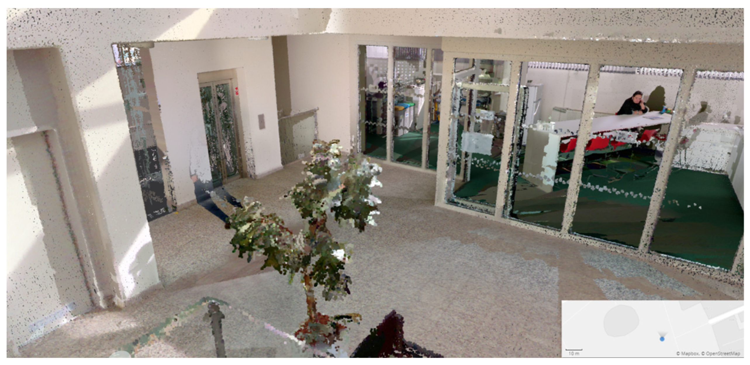
1.2.1. Laser Scanning (LIDAR)

Laser scanning is a surveying method for measuring data that has been known since the 1960s. LIDAR (light detection and ranging) technology makes it possible to measure and acquire data from a variety of surfaces, including buildings, terrain or other objects. The product of such scanning are point clouds resulting from millions of measurements of X, Y and Z coordinates. Laser scanners equipped with photodetectors, advanced sensors, receivers, laser beams and GNSS systems make it possible to achieve a measurement result that best reflects reality. GNSS is a global positioning system based on various satellite constellations (GPS, GALILEO, GLONASS, BEIDOU, etc.) which provides coordinates of the points detected in well-known reference systems such as WGS84, ITRF, ETRF, etc. [7]. The device, depending on the parameters of the sensor, can emit millions of light pulses per second. Each pulse, reflecting off the object being scanned, travels a distance between the scanner and the object, measuring the distance in relation to the speed of light. The result is a measured point, and the collection of all points forms a three-dimensional visualization of reality, called a cloud. With the development of LIDAR technology, different types of laser scanners have emerged. The most popular are stationary scanners (TLS). Two types of TLS scanners are used in the construction sector: PS (phase shift), and TOF (time of flight) scanners, depending on the type of sensor, the methodology used for positioning varies [8]. New ToF scanners, combined with wave form digitization (WFD) technology, which allows density, precision and acquisition resolution to be maintained in a cloud of an extremely high number of points over the entire range of measurements performed, are being heavily used in historic preservation [9]. More recently, mobile scanners (MLS) are becoming more common. Below are the characteristics of each of these types of devices.
The most common laser scanning technique, which has been used for many years, is ground-based scanning with desktop scanners (TLS). Such devices, usually placed on a tripod, emit hundreds of thousands or even millions of light beams per second to make a three-dimensional depiction of reality in the form of a dense point cloud. It can be said that a terrestrial laser scanner is a very fast portable station, measuring points in space using three spherical coordinates: r, h, v. From the light beam reflected from a given point, the scanner reads the range (r), horizontal angle (h) and vertical angle (v). These coordinates are then converted to the Cartesian system to result in x, y, z coordinate values as the result of measuring a given point.
Like other surveying methods, terrestrial laser scanning is also subject to the risk of errors. The accuracy of the measurement is affected by such factors as, for example, instrumental imperfections, atmospheric conditions, the shape of the object being scanned, the environment, lighting and the configuration of the scanner settings. However, only instrumental imperfections affect the calibration of the scanner, so that errors due to other factors are negligible [10]. In recent years, there have been intensive developments in the field of laser scanning, resulting in new devices and capabilities. An example is the growing use of mobile laser scanners (MLSs), which are particularly helpful when scanning hard-to-reach areas where the use of a stationary scanner would be very difficult or impossible. Despite lower measurement accuracy than TLS, mobile scanners can be more useful due to their ability to scan from handheld devices, which takes much less time than taking measurements with a stationary device.
The figure below (Figure 2) shows a section of a point cloud taken with a mobile scanner from NavVis (München, Germany). The device is equipped with two laser scanners that record geometric data, a SLAM (simultaneous localization and mapping) algorithm that makes it possible to record the trajectory of the device’s movement, as well as cameras that are used to acquire images for the later coloring of the point cloud or creating 360° panoramas used in a virtual tour [11].
Depending on the purpose for which the point cloud is to be used, the expected accuracy and the time in which the measurement is to be made, the appropriate scanning method should be selected (Figure 3 and Figure 4). Currently, the best solution is a combination of TLS and MLS, since the use of these two methods allows to obtain the most complete representation of reality. The following table (Table 2) shows a comparison of the most important parameters of selected fixed and mobile scanners: range, scanning performance, distance measurement error and resolution of generated images.
As can be seen from the above summary, a desktop scanner has a smaller measurement error, a larger range and a higher image resolution than a mobile scanner. However, the latter has a significantly higher scanning capacity, so the same amount of work can be completed much more quickly. This is a major advantage, since in most project cases a model with LOD 300 (Level of Detail) is required, and the input data, in the form of a point cloud acquired from measurements with the mobile scanner, have sufficient accuracy for this purpose. LOD 300 is one of the standards of BIM. According to the definition of this level, the building is represented by specific objects and systems which make it possible to make all the necessary analysis, measurements and calculations. In general, it is used during the phase of construction design since the represented level of detail is suitable for producing construction documents and coordinating different disciplines.

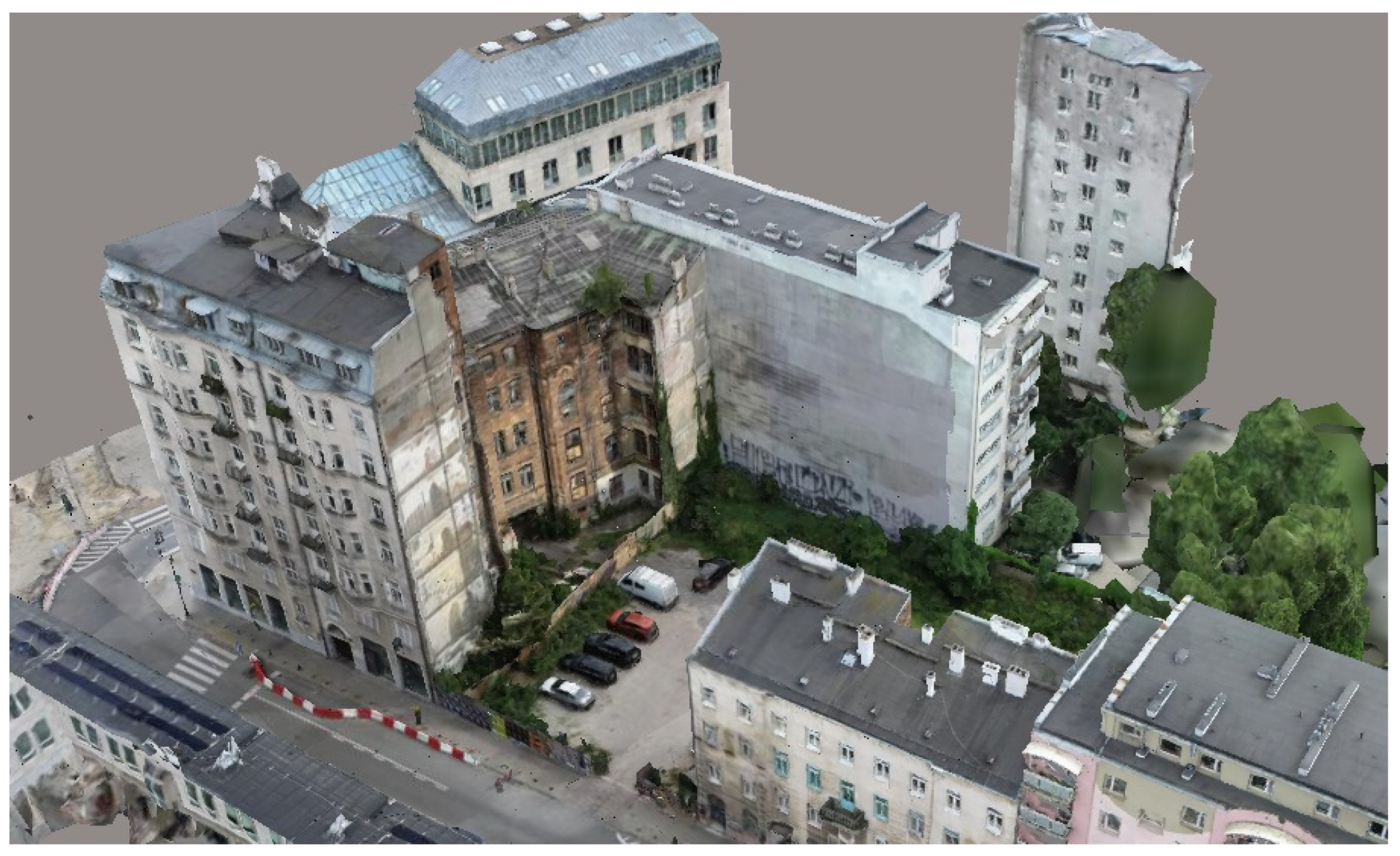
1.2.2. Digital Photogrammetry

Another popular technique for acquiring 3D geometric data is digital photogrammetry. The measurement method is based on the principle of triangulation. As a base, it uses digital images acquired with sensors that read electromagnetic radiation in different wavelength ranges. Unlike classical photography, digital images receive not only visible and near-infrared radiation, but almost the entire range of electromagnetic radiation. Images can be acquired in a variety of ways, the most common being with scanners, cameras or photogrammetric cameras, which are usually placed on drones. Unmanned aerial vehicles (UAVs) are equally heavily used in the preservation and conservation of cultural heritage sites [14]. The chosen measuring device takes thousands of images in a short period of time, which later, with the help of tangent points, are combined into a whole in specialized software, such as Reality Capture, for example. The results of measurements by the photogrammetry technique can be orthophotos, point clouds or mesh models (Figure 5).
Digital photogrammetry is characterized on the one hand by lower accuracy than laser scanning, and on the other by higher quality color images. In addition, it is a fast measurement technique, so it is used for complex objects, as well as in situations where the principal is primarily concerned with visual effects rather than precise measurement. Photogrammetry is mainly used visually, as it represents the detail of an object much better than laser scanning. However, digital photogrammetry can achieve a resolution of less than one mm in the study of artifact details, if handled correctly [6].

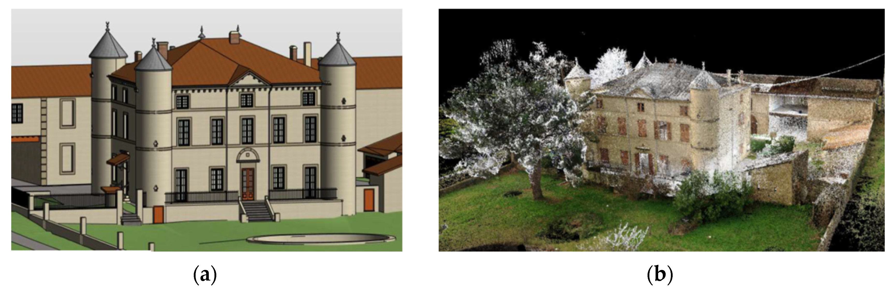
1.3. BIM Modeling Based on Point Clouds

At present, there is an intensive development of the use of BIM technology in construction [15]. More and more investments are appearing where the preparation of a BIM model is no longer just a recommendation, but a requirement of the investor. Therefore, it is necessary to constantly work on improving and optimizing the process of preparing the said model. An important factor affecting modeling is the accuracy of the input data and its saturation with relevant information about the object in question. Such data are provided by point clouds, the methods of obtaining which were described in the above chapters. To fully exploit the potential of input data in the form of point clouds, it is recommended to use an object-oriented approach to modeling. This makes it possible to generate as much information as possible that can be useful during further work with the model. Such an approach to modeling from a point cloud can be implemented, among other things, during the inventory of buildings, reverse engineering, the reconstruction or repair of historic buildings, as well as the measurement of distances, angles and ordinates of selected points on a building or dimensional analysis of distortion and height maps [16].

1.4. BIM Definition

BIM is a complex concept with more than one definition. Most commonly, BIM is defined as building information modeling (BIM). It is the process of storing, sharing, exchanging and managing various types of information throughout the life cycle of a building: from the conceptual phase, through construction, maintenance and up to the eventual demolition stage. BIM is not just a three-dimensional model created by designers, but an undertaking undertaken by a specific group of people [17]. One can consider the concept in two ways—from a broad or narrow perspective. In the broader sense, it is said to be a process based on the cooperation of people, information systems, databases and software. In addition, BIM can also include computer hardware, tangible and intangible resources and knowledge. On the other hand, in a strict sense, BIM is seen as a semantic database of a construction object accompanying it throughout its life cycle [18].
BIM can also be defined as building information model (BIM), which is a digital description of a building’s functional and physical properties, being a source of knowledge and all data about the facility. The premise is that the model must be fully accessible to stakeholders in the development process, as it forms the basis for decision-making during the life cycle of a building—from its initial conception to its eventual demolition. Another definition of BIM is building information management (BIM), which is the organization and control of investment processes by using the parameters of a digital model of the facility to perform information exchange throughout the investment cycle. Centralized data exchange; visual communication through three-dimensional objects; identification of opportunities at an early stage; sustainable, efficient and interdisciplinary design; on-site inspection; and updating documentation to reflect the real world are just some of the benefits of building information management [19].
The main purpose of BIM is to streamline the investment process; automate the design process [20]; optimize the costs associated with the implementation of the investment, operation and maintenance [21]; and to minimize the possible negative impact of the investment on the environment. The following assumptions of building information modeling technology can be found in the literature: all the information contained in the model is true, up-to-date, complete, readable, accessible and easy to modify [22]; the information in the form of data contained in the digital object model is suitable for automatic processing; the model accompanies the building during its entire life cycle; the building model is independent of specific software; the digital building model contains information that is available to an appropriate extent for all participants in the investment process and is used as an area of cooperation between them; the individual components of the object information model contain data on their essence and behavior [23].
In the R&D work, an attempt was made to integrate the mentioned three technologies: laser scanning, digital photogrammetry and BIM. As part of the experimental work, three BIM models were built at a high level of geometric detail. The aim of the study was to extract data from various disjointed sources and to build a good BIM model based on them.

2. Literature Review

2.1. State of the Art

Heritage preservation is a complex and evolving field that requires a delicate balance between traditional methods and modern technology. A TLS conceptual framework has already been developed for enhancing the accuracy, efficiency and richness of heritage documentation, contributing to the broader field of heritage preservation and emphasizing the importance of embracing technological advances while respecting historical integrity [24]. BIM has become a relevant computerized system for improving heritage management. The research developed a BIMlegacy protocol to improve workflow in interdisciplinary heritage projects. Research techniques used include documentary analysis, semi-structured interviews and focus groups. In this case, HBIM is proposed as a virtual model that will store heritage data and express processes. The protocol is divided into eight phases: the registration of the building, the identification of intervention options, the design of the intervention, the planning of physical intervention, physical intervention, handover, conservation and cultural dissemination [25]. TLS and photogrammetry are enabling experts to scan buildings with a new level of detail. Image-based techniques are considered cost-effective, highly flexible and efficient in creating a high-quality textured 3D model. Such hybrid scans can be imported into BIM environments [26]. Creating highly accurate HBIM models requires the use of several reality capture tools, such as terrestrial laser scanning (TLS), photogrammetry, unmanned aerial vehicles (UAVs), etc. The study identified knowledge gaps including the lack of guidelines for using static TLS surveys to capture HBIM data, the lack of a robust automated framework for creating/transferring 3D geometries and their attributes from TLS data to BIM units, and insufficient use of TLS for long-term monitoring and change detection [27]. Other studies also point to future research directions, including: (1) controlling hardware and software costs, (2) improving data processing capabilities, (3) automatic scanning scheduling, (4) integrating digital technologies and (5) adopting artificial intelligence [28].

2.2. The Objectives

A review of the literature shows that there are many literature studies, but case studies of the use of TLS and photogrammetry for HBIM are far fewer. Thus, the main purpose of this paper is to present a methodology for processing integrated data from disjointed sources. Such a process of acquisition, extraction and modeling can bring a few benefits. Advantages, disadvantages, opportunities and threats can be identified during the practical work. Three models were built to achieve these goals: fort, plant, castle. The methodology developed below can be applied to other cases after considering spatial, urban or environmental considerations.

3. Materials and Methods: Workflow—From Point Clouds to Building Information Model

The procedure for creating a BIM model from data acquired in the form of point clouds is referred to as scan to BIM. The diagram below (Figure 6) shows the main steps in the process of modeling a building from a point cloud.
The input dataset is an existing building. To obtain its representation in the form of a point cloud, it is necessary to choose the appropriate data acquisition method: laser scanning (TLS and/or MLS) and/or digital photogrammetry. For the point cloud to be effectively used later for surveying and BIM, the following questions must be answered: what resolution is needed to capture all building details with sufficient precision? What degree of shading is acceptable? What parameters must the scanning device meet, or what settings are required? How many scans should be made? Where should the scanner be placed? Depending on the specifics of the project, the desired effect and technical capabilities, the answers to the above questions will vary.
The point cloud acquired by laser scanning should be processed in appropriate software, such as Autodesk ReCap Pro 2023 (commercial) or Cloud Compare 2.13.1 (open source) [29]. The most common activities performed at this stage are noise reduction—involving the detection and removal of randomly scanned objects that are not part of the actual study; point cloud registration—involving the combination of multiple point clouds of the same object from different parts of the scan; and meshing—the creation of triangulation surfaces that can be transformed into a 3D model using special software [30]. It is also possible to georeference the point cloud with GNSS or transfer it to the local coordinate system of the BIM software. This will enable the exact location of the input data, which can facilitate the subsequent use of the BIM model, to be determined. A point cloud prepared in this way should be exported to an appropriate format. The choice of the right option depends primarily on the BIM software in which the object model will be created, but also on the potential representation of the data one wants to obtain. One of the most popular programs for modeling building information is Autodesk Revit, which supports point clouds in the RCP (ReCap project) or RCS (ReCap scans) formats. An RCP file indicates the individual scans and contains the information about them whereas RCS is a single point cloud scan file or unified point cloud data. Usually, several RCS files are included in one RCP project file [31]. Pre-prepared input data are loaded using the appropriate tools. If georeferencing has not been provided beforehand, the point cloud should be manually located at the right place in the model.
The final step in the scan-to-BIM process is modeling the object. Using the tools available in the software, the necessary components are created, which are then placed in the model based on the location visible in the loaded point cloud. It is also helpful to use existing object libraries provided by manufacturers. Although, in the case of many projects, there is anyway a need to create your own BIM library components, for example, in the graphical family editor in Autodesk Revit. It should be remembered that the model developed in this way must meet the criteria described in the principal’s requirements. These relate primarily to the level of detail (LOD) of the model, the scope of work, the rules for naming components, as well as the necessary parameters and file storage format. The product of the process is a digital information model of the construction object. It is good practice to save and transfer the file not only in native form, but also in an open data exchange format such as IFCs (Industry Foundation Classes). Although it should be noted that IFC still does not provide full and seamless interoperability between different applications. The degree of data loss depends on the MVD (model view definition) configuration and the skill of the users.

4. Results—Case Studies

The scan-to-BIM process is increasingly used in the AEC (architecture, engineering and construction) industry because of the opportunities it creates. BIM models created on the basis of point clouds are used in various types of investment and construction projects, such as retrofits, renovations, extensions or reconstructions. This chapter presents some examples of projects implemented according to the scan-to-BIM procedure, critically pointing out some of the limitations and challenges that researchers still face.
The first example shows the renovation of a historic fort (Figure 7). The purpose of using a parametric model of the fort was to make a detailed inventory of the existing condition. On this basis, a detailed analysis of the building was to be conducted and a renovation project developed. The BIM model of the building was made based on a point cloud obtained by terrestrial laser scanning. The acquired data were processed in Autodesk ReCap: the clouds were cropped to the extent of the study area and cleared of unnecessary points, and the individual scans were automatically pieced together. The exported file in RCP format was then loaded into Autodesk Revit, where the model was developed according to the LOD 300 level of detail. The difficulties that can be encountered with these types of objects are primarily specific construction. The walls inside the fort were rounded and irregular, which made it impossible to use the default parametric families. It was necessary to directly model based on the point cloud. The model thus created, after appropriate modifications, can also be used in the subsequent phases of the construction process, including the design phase, the implementation of the project, as well as the operation of the modernized building. In such a case, it is necessary to determine the nature of the building materials used and the state of preservation of the manufactures, which cannot be achieved with TLS and photogrammetry alone, and is a strength of BIM (richness in non-graphical data on building materials, for example).
Another example of the application of the scan-to-BIM process is the reconstruction of an industrial facility (Figure 8). The point cloud was acquired by terrestrial laser scanning using a desktop scanner. The purpose of developing the digital model was to provide a detailed inventory of the existing condition of the buildings along with their surroundings. The point cloud was processed in Autodesk ReCap 2022 software: the scans were integrated together, then the data were cropped to the study area and cleared of unnecessary points. The resulting file in RCP format was loaded into Autodesk Revit 2022, where a BIM model of the site was made. The scope of modeling included not only the structure of the buildings, but also all sanitary and electrical installations, as well as elements of the surrounding area: terrain, pavement, road signs and others at the LOD 300 level of detail. Based on the model, analyses of the structure and installations were conducted, and a project for the reconstruction of the facility was developed.
From the above examples, it is possible to see the wide applicability of a parametric model of a given construction object developed from laser scanning data. The advantage of the scan-to-BIM process is the quality of the input data, which makes it possible to depict reality very accurately. In addition, the use of this method of compiling an object inventory significantly reduces the time of data acquisition, as well as increasing the accuracy of the acquired data. However, despite building models at a high level of geometric detail, there is still the problem of the semantic enrichment of such models with non-graphical data [32].

Historical/Heritage Building Information Modeling (HBIM)

BIM technology is mainly associated with new construction, but over the past few years we have seen a definite increase in the application of this methodology to historic buildings. Protecting architectural heritage presents numerous challenges due to the complexity and diversity of historical settings, such as irregular shapes of architectural elements or incomplete or absent building documentation, among others [33]. Work aimed at preserving cultural heritage, carried out at historical sites or archeological sites, is very complex: it involves geometry; analysis of chemical, physical and mechanical properties; as well as existing documentation [34,35]. Any action taken requires a horizontal approach, in which all data about the object will be considered. Historic structures can be subject to various types of construction projects, including restoration, conservation or change in use. The application of BIM methodologies in heritage preservation solves many problems, as it helps to manage documentation well, perform geometry analysis and the parametric model is a detailed database about the site. Approaches to the preservation of historical heritage using BIM technology have been referred to by the term HBIM (heritage/historical building information modelling). In the implementation of HBIM, three main stages can be distinguished: the preparation of input data, among others through the scan to BIM process; the selection of appropriate software and parameters to depict reality as faithfully as possible; and the development of a parametric digital model of a given historical building [36].
Historical BIM was applied, among other things, during the restoration and conservation process of one of France’s medieval castles (Figure 9). A parametric model of the structure was created from a point cloud obtained by laser scanning. An inventory of the existing condition was carried out to develop a renovation project and a maintenance plan.
The proper conservation of historic buildings is a complex process that requires the cooperation of specialists from various fields [37]. A key aspect is the detailed analysis of the structure, during which a great deal of diverse information must be pieced together. The previously mentioned digital photogrammetry or laser scanning makes it possible to obtain the geometry and texture of a given object, based on which a 3D model can be developed. At the same time, a parallel analysis is carried out from a historical perspective, which involves checking and verifying historical sources and existing documentation. In order to proceed with the preservation of a historic building, the following data should be collected (Table 3): the geometry of the building, i.e., all dimensions and volume; information on the architectural style in which the analyzed building was designed, including characteristic structural elements and techniques; characteristics and juxtapositions of the materials; the degree of degradation of the building’s facades; the facade interventions carried out; possible structural damage with a detailed description of the extent of the intervention; as well as a simulation of the impact of external factors on the building and the risks involved. If all of the aforementioned information is included in the BIM model, it will be possible to produce the necessary drawings, statements, documentation or analysis more easily and quickly using the BIM software of choice. However, as research shows, BIM applications do not always keep up with the development of theory and the needs of construction-sector practitioners. The ability to constantly change and learn is the driving force behind BIM methodology and will be the key to future smart applications [38].
The term HBIM does not have to refer to just one building. It can also include a set of buildings or an entire urban layout. HBIM can be beneficial for facilitating data-driven decision-making in the preservation process. HBIM promises high geometric fidelity and the management of non-graphic heritage data [39]. However, time will tell whether it will see full adoption in the building sector.

5. Discussion

Point clouds as a source of object data can significantly speed up the design process, especially if implemented using BIM technology. The most common technique for acquiring point clouds is a combination of several methods: digital photogrammetry and laser scanning—stationary and/or mobile. This makes it possible to obtain the most accurate real-world imaging of the object, and choosing the right measurement methods will save time in creating a database about the object. Good-quality input data are the basis for creating a functional BIM model of the object in the scan-to-BIM process. Such a model can be used during the entire life cycle of a building, including property management, operation, modernization, renovation or refurbishment. There is an ongoing problem in the market with the transfer of BIM models to owners/operators, and their knowledge and capabilities do not allow for effective management using such a model [40].
Over time, BIM models will become more sophisticated, imbued with IoT (internet of things) sensors and perhaps managed by artificial intelligence. Hence, they must be semantically correct for research or management purposes [41]. More research is needed on automating the process of modeling from point clouds, automating the process of entering non-graphical data, or automating the preparation of documentation. This may open a new era of BIM maturity that will follow “CAD 3D”, “closed BIM” and “openBIM” [42]. The integration of the technologies exchanged has taken place. It is necessary to move on. The contribution of this article proves that it is necessary to look for new research directions toward automating the processes of modeling and managing information on buildings.

6. Conclusions

The integration of laser scanning with BIM technology brings many benefits. The object data acquired are characterized by a high level of detail and saturation with various types of information. The best effect is obtained by combining different measurement techniques, most often laser scanning and digital photogrammetry. Before starting the project, it is necessary to analyze which method will be most effective in a specific case; that is, what data are needed to achieve the desired effect. This makes it possible to create an accurate parametric model based on them, which is a rich database about the building. The BIM model has several applications not only in the entire construction process, but also at the stage of building operation. Generating 2D documentation, bills of materials, conducting any analysis or developing demolition or renovation projects is much easier than with traditional methods. Implementing such an approach in accordance with good practices positively influences the optimization of investment time and costs.
The scan-to-BIM process also carries some risks. Error propagation can occur as a result of modeling from existing data (e.g., from paper documentation or CAD files). Similarly, if the data are not properly acquired, this affects all further stages of the process. If the accuracy of the point cloud is too low, it will affect the quality and content of the BIM model, which may lack the necessary information for subsequent work. On the other hand, higher-than-required point cloud detail may make it difficult to work from due to the file size, which will be too large for the chosen modeling software. In practice, the phenomenon of so-called “overmodeling”, i.e., the over-detailing of models or library components, has been observed. In addition, there are costs to be reckoned with in terms of providing appropriate scanning equipment and possible training for working with point clouds. There are also difficulties associated with using HBIM. It should be remembered that BIM technology was developed primarily for newly constructed buildings, to assist the development process from the very beginning. When it comes to existing historic buildings, many questions still arise due to the complexity and diversity of historic buildings. Many architectural style-specific elements require the creation of a new individual parametric family, which can significantly increase model development time. This area still requires a great deal of analysis and improvement to take full advantage of all the possibilities offered by BIM methodology.

Author Contributions

Conceptualization, A.S.B. and A.K.; methodology, A.S.B. and A.K.; software, A.K.; validation, A.S.B. and A.K.; formal analysis, A.K.; investigation, A.K.; data curation, A.K.; writing—original draft, A.S.B. and A.K.; writing—review and editing, A.S.B.; supervision, A.S.B.; funding acquisition, A.S.B. All authors have read and agreed to the published version of the manuscript.

Funding

This research received no external funding.

Institutional Review Board Statement

Not applicable.

Informed Consent Statement

Not applicable.

Data Availability Statement

The original contributions presented in the study are included in the article.

Acknowledgments

We would like to thank the Department of Geodesy and Cartography at Warsaw University of Technology and SXD Polska Ltd. for their support in carrying out the research.

Conflicts of Interest

Author Alicja Kubrat was employed by the company SXD Poland Ltd. The remaining author declares that the research was conducted in the absence of any commercial or financial relationships that could be construed as a potential conflict of interest.

References

  1. Mengiste, E.; Prieto, S.A.; De Soto, B.G. Comparison of TLS and photogrammetric 3D data acquisition techniques: Considerations for developing countries. In ISARC, Proceedings of the International Symposium on Automation and Robotics in Construction, Bogotá, Colombia, 12–15 July 2022; IAARC Publications: Pittsburgh, PA, USA, 2022; Volume 39, pp. 491–494. [Google Scholar]
  2. Grilli, E.; Menna, F.; Remondino, F. A review of point clouds segmentation and classification algorithms. Int. Arch. Photogramm. Remote Sens. Spat. Inf. Sci. 2017, XLII-2/W3, 339–344. [Google Scholar] [CrossRef]
  3. Morgenstern, H.; Raupach, M. Quantified point clouds and enriched BIM-Models for digitized maintenance planning. MATEC Web Conf. 2022, 364, 05001. [Google Scholar] [CrossRef]
  4. Geoportal. Available online: https://mapy.geoportal.gov.pl/imap/Imgp_2.html (accessed on 18 May 2024).
  5. Kadhim, N.; Mhmood, A.D.; Adb-Ulabbas, A.H. The creation of 3D building models using laser-scanning datafor BIM modeling. IOP Conf. Ser. Mater. Sci. Eng. 2021, 1105, 012101. [Google Scholar] [CrossRef]
  6. Lichti, D.D.; Gordon, S.J.; Stewart, M.P.; Franke, J.; Tsakiri, M. Comparison of digital photogrammetry and laser scanning. In Proceedings of the International Society for Photogrammetry and Remote Sensing, Hyderabad, India, 7–9 December 2002; pp. 39–44. [Google Scholar]
  7. Dardanelli, G.; Maltese, A.; Pipitone, C.; Pisciotta, A.; Lo Brutto, M. NRTK, PPP or static, that is the question. Testing different positioning solutions for GNSS survey. Remote Sens. 2021, 13, 1406. [Google Scholar] [CrossRef]
  8. Suchocki, C.; Damięcka-Suchocka, M.; Katzer, J.; Janicka, J.; Rapiński, J.; Stałowska, P. Remote detection of moisture and bio-deterioration of building walls by time-of-flight and phase-shift terrestrial laser scanners. Remote Sens. 2020, 12, 1708. [Google Scholar] [CrossRef]
  9. Masciotta, M.G.; Sanchez-Aparicio, L.J.; Oliveira, D.V.; Gonzalez-Aguilera, D. Integration of laser scanning technologies and 360º photography for the digital documentation and management of cultural heritage buildings. Int. J. Archit. Herit. 2023, 17, 56–75. [Google Scholar] [CrossRef]
  10. Pilgrim, L.; Sabzali, M. Investigation of Correlation between Self-Calibration Parameters of Terrestrial Laser Scanner (TLS). Asian J. Geoinform. 2023, 23, 2311016-1–2311016-16. [Google Scholar]
  11. Schmidt, J.; Volland, V.; Iwaszczuk, D.; Eichhorn, A. Detection of hidden edges and corners in slam-based indoor point clouds. Int. Arch. Photogramm. Remote Sens. Spat. Inf. Sci. 2023, XLVIII-1/W, 443–449. [Google Scholar] [CrossRef]
  12. TPI. Available online: https://tpi.com.pl/produkt/faro-focus-premium (accessed on 18 May 2024).
  13. NavVis. Available online: https://www.navvis.com/vlx (accessed on 18 May 2024).
  14. Pepe, M.; Alfio, V.S.; Costantino, D. UAV platforms and the SfM-MVS approach in the 3D surveys and modelling: A review in the cultural heritage field. Appl. Sci. 2022, 12, 12886. [Google Scholar] [CrossRef]
  15. Zawada, K.; Rybak-Niedziółka, K.; Donderewicz, M.; Starzyk, A. Digitization of AEC Industries Based on BIM and 4.0 Technologies. Buildings 2024, 14, 1350. [Google Scholar] [CrossRef]
  16. Borkowski, A.S. BIM model from a point cloud. Build. Sci. 2020, 1, 42–44. [Google Scholar] [CrossRef]
  17. Eastman, C.; Teicholz, P.; Sacks, R.; Liston, K. BIM Handbook: A Guide to Building Information Modeling for Owners, Managers, Designers, Engineers and Contractors; John Wiley & Sons: Hoboken, NJ, USA, 2011; 626p. [Google Scholar]
  18. Borkowski, A.S. A Literature Review of BIM Definitions: Narrow and Broad Views. Technologies 2023, 11, 176. [Google Scholar] [CrossRef]
  19. Tomana, A. BIM Innovative Technology in Construction. Basics, Standards, Tools; PWB MEDIA Zdziebłowski Spółka Jawna: Kraków, Poland, 2016; pp. 59–60. ISBN 978-83-944969-0-6. (In Polish) [Google Scholar]
  20. Kochański, Ł.; Borkowski, A.S. Automating the conceptual design of residental areas using visual and generative programming. J. Eng. Des. 2024, 35, 195–216. [Google Scholar] [CrossRef]
  21. Borkowski, A.S. Low-Cost Internet of Things Solution for Building Information Modeling Level 3B—Monitoring, Analysis and Management. J. Sens. Actuator Netw. 2024, 13, 19. [Google Scholar] [CrossRef]
  22. Kasznia, D.; Magiera, J.; Wierzowiecki, P. BIM in Practice; PWN Scientific Publishers SA: Warsaw, Poland, 2017; pp. 13–14. ISBN 978-83-01-21052-6. (In Polish) [Google Scholar]
  23. Adamus, Ł. Building Information Modeling (BIM): Theoretical foundations. Pr. Inst. Tech. Bud. 2012, 41, 13–26. (In Polish) [Google Scholar]
  24. Liu, J.; Willkens, D.; Gentry, R. A Conceptual Framework for Integrating Terrestrial Laser Scanning (TLS) into the Historic American Buildings Survey (HABS). Architecture 2023, 3, 505–527. [Google Scholar] [CrossRef]
  25. Jordan-Palomar, I.; Tzortzopoulos, P.; García-Valldecabres, J.; Pellicer, E. Protocol to manage heritage-building interventions using heritage building information modelling (HBIM). Sustainability 2018, 10, 908. [Google Scholar] [CrossRef]
  26. Alshawabkeh, Y.; Baik, A.; Miky, Y. Integration of laser scanner and photogrammetry for heritage BIM enhancement. ISPRS Int. J. Geo-Inf. 2021, 10, 316. [Google Scholar] [CrossRef]
  27. Liu, J.; Azhar, S.; Willkens, D.; Li, B. Static terrestrial laser scanning (TLS) for heritage building information modeling (HBIM): A systematic review. Virtual Worlds 2023, 2, 90–114. [Google Scholar] [CrossRef]
  28. Wu, C.; Yuan, Y.; Tang, Y.; Tian, B. Application of terrestrial laser scanning (TLS) in the architecture, engineering and construction (AEC) industry. Sensors 2021, 22, 265. [Google Scholar] [CrossRef]
  29. Available online: https://cloudcompare-org.danielgm.net/release/ (accessed on 10 May 2024).
  30. Pocobelli, D.P.; Boehm, J.; Bryan, P.; Still, J.; Grau-Bové, J. BIM for heritage science: A review. Herit. Sci. 2018, 6, 30. [Google Scholar] [CrossRef]
  31. Autodesk. Available online: https://help.autodesk.com/view/NAV/2022/ENU/?guid=GUID-7F1C93E2-66A8-4884-85E1-15B180E0C46F (accessed on 8 June 2024).
  32. Quattrini, R.; Pierdicca, R.; Morbidoni, C. Knowledge-based data enrichment for HBIM: Exploring high-quality models using the semantic-web. J. Cult. Herit. 2017, 28, 129–139. [Google Scholar] [CrossRef]
  33. Eadie, R.; Clifford, S.; Stoyanov, V. Building information modeling (BIM) automated creation of gothic arch windows from point clouds. In Proceedings of the XXII International Scientific Conference on Construction and Architecture VSU’2022, Sofia, Bulgaria, 6–8 October 2022; p. 2. [Google Scholar]
  34. Sánchez-Aparicio, L.J.; Del Pozo, S.; Ramos, L.F.; Arce, A.; Fernandes, F.M. Heritage site preservation with combined radiometric and geometric analysis of TLS data. Autom. Constr. 2018, 85, 24–39. [Google Scholar] [CrossRef]
  35. Wei, O.C.; Chin, C.S.; Majid, Z.; Setan, H. 3D documentation and preservation of historical monument using terrestrial laser scanning. Geoinf. Sci. J. 2010, 10, 73–90. [Google Scholar]
  36. Moyano, J.; Carreño, E.; Nieto-Julián, J.E.; Gil-Arizón, I.; Bruno, S. Systematic approach to generate Historical Building Information Modelling (HBIM) in architectural restoration project. Autom. Constr. 2022, 143, 104551. [Google Scholar] [CrossRef]
  37. Roca, P. Restoration of historic buildings: Conservation principles and structural assessment. Int. J. Mater. Struct. Integr. 2011, 5, 151–167. [Google Scholar] [CrossRef]
  38. Pezeshki, Z.; Ivari SA, S. Applications of BIM: A brief review and future outline. Arch. Comput. Methods Eng. 2018, 25, 273–312. [Google Scholar] [CrossRef]
  39. Saricaoglu, T.; Saygi, G. Data-driven conservation actions of heritage places curated with HBIM. Virtual Archaeol. Rev. 2022, 13, 17–32. [Google Scholar] [CrossRef]
  40. Bosch, A.; Volker, L.; Koutamanis, A. BIM in the operations stage: Bottlenecks and implications for owners. Built Environ. Proj. Asset Manag. 2015, 5, 331–343. [Google Scholar] [CrossRef]
  41. Christenson, M. Problematizing the model-building duality: Examining the New Sacristy at S. Lorenzo, Florence, Italy. Front. Archit. Res. 2023, 12, 651–663. [Google Scholar] [CrossRef]
  42. Borkowski, A.S. Evolution of BIM: Epistemology, genesis and division into periods. J. Inf. Technol. Constr. (ITcon) 2023, 28, 646–661. [Google Scholar] [CrossRef]
Figure 1. Example of a point cloud—The Old Town in Warsaw, Poland [4].
Eng 05 00125 g001
Figure 2. Example of a point cloud—office building—compiled with mobile scanner (SXD Poland (Warsaw, Poland) resource).
Eng 05 00125 g002
Figure 3. Terrestrial Laser Scanner Faro Focus Premium (Warsaw, Poland) (source: [12]).
Eng 05 00125 g003
Figure 4. Mobile Laser Scanner NavVis VLX 3 (München, Germany) (source: [13]).
Eng 05 00125 g004
Figure 5. Three-dimensional mesh created with the use of digital photogrammetry (SXD Poland resource).
Eng 05 00125 g005
Figure 6. From point clouds to BIM—workflow (own elaboration).
Eng 05 00125 g006
Figure 7. Fort renovation—BIM model (a) based on point cloud (b) (SXD Poland resources).
Eng 05 00125 g007
Figure 8. Plant reconstruction—BIM model (a) based on point cloud (b) (SXD Poland resources).
Eng 05 00125 g008
Figure 9. Castle renovation and conservation—BIM model (a) based on point cloud (b) (SXD Poland resources).
Eng 05 00125 g009
Table 1. Some of the most popular point cloud file formats with detailed information (own elaboration based on [5]).
PC File FormatData Storage TypeExample of BIM Modeling SoftwarePotential Representation
RCP, RCSASCIIAutodesk RevitSurface normals, texture, color, transparency, data confidence value and coordinates
E57ASCII and BinaryGraphisoftArchicad, Tekla StructuresNormals, scalar density and 3D geometry, texture and color
XYZASCIIGraphisoftArchicad, Tekla Structures3D geometry, texture, color, no unit standardizations
LASBinaryTeklaThe ground in addition to surface structures
Table 2. Comparison between the parameters of MLS and TLS (own elaboration).
ParameterTLS Faro Focus Premium
(Figure 3)
MLS NavVis VLX
(Figure 4)
Range70–350 m100 m
3D scanning capacity800–1500 m/h21500–3000 m/h2
Distance measurement error±1 mm±6 mm
Resolutionup to 266 Mpix RGBup to 34 Mpix RGB
Table 3. General information for heritage building to be conserved (own elaboration based on [30]).
InformationDescription
Geometrical dataDimensions, cubic area, etc.
Architectural styleSpecific building components and construction techniques
MaterialsCharacteristics: materials represented in the views with different hatch, in labels
Façade degradationHatches in the elevation views represent specific degradations
Façade interventionsHatches in the elevation views represent interventions, with symbols, tables and detailed planned actions
Damage survey (if required)If there is any structural damage in the building, a damage survey is required to plan structural interventions
Environmental parameters and their future effectsPossible simulation to inform the maintenance of the building and to help make decisions; the prediction and interpretation of risks
Disclaimer/Publisher’s Note: The statements, opinions and data contained in all publications are solely those of the individual author(s) and contributor(s) and not of MDPI and/or the editor(s). MDPI and/or the editor(s) disclaim responsibility for any injury to people or property resulting from any ideas, methods, instructions or products referred to in the content.

