Abstract
Current Satellite-Based Augmentation Systems (SBASs) improve the positioning accuracy and integrity of GPS satellites and provide safe civil aviation navigation services for procedures from en-route to LPV-200 precision approach over specific regions. SBAS systems, such as WAAS, EGNOS, GAGAN, and MSAS, already operate. The development of operational SBAS systems is in transition due to the extension of L1 SBAS services to new regions and the improvements expected by the introduction of dual frequency multi-constellation (DFMC) services, which allow the use of more core constellations such as Galileo and the use of ionosphere-free L1/L5 signal combination. The UKSBAS Testbed is a demonstration and feasibility project in the framework of ESA’s Navigation Innovation Support Programme (NAVISP), which is sponsored by the UK’s HMG with the participation of the Department for Transport and the UK Space Agency. UKSBAS Testbed’s main objective is to deliver a new L1 SBAS signal in space (SIS) from May 2022 in the UK region using Viasat’s Inmarsat-3F5 geostationary (GEO) satellite and Goonhilly Earth Station as signal uplink over PRN 158, as well as L1 SBAS and DFMC SBAS services through the Internet. SBAS messages are generated by GMV’s magicSBAS software and fed with data from the Ordnance Survey’s station network. This paper provides an assessment of the performance achieved by the UKSBAS Testbed during the last two years of operations at the SIS and user level, including a number of experimentation campaigns performed in the aviation and maritime domains, comprising ground tests at airports, flight tests on aircraft and sea trials on a vessel. This assessment includes, among others, service availability (e.g., APV-I, LPV-200), protection levels (PL), and position errors (PE) statistics over the service area and in a network of receivers.
1. Introduction
UKSBAS Testbed is a European Space Agency NAVISP Element 3 sponsored by the UK Department for Transport and the UK Space Agency that aims to demonstrate a new UK national SBAS service to aid in assessing the options for future operational SBAS capabilities. The project is led by Viasat, while GMV collaborates by offering a technical solution to produce GPS augmentation SBAS L1 messages using real-time measurements from Continuously Operating Reference Stations (CORS) and generating a signal that is uplinked from Goonhilly Earth Station. The signal has been disseminated since 2022 through the Viasat in-orbit geostationary (GEO) navigation transponder. In 2023, the infrastructure was updated with next-generation SBAS DFMC provision that augments GPS and Galileo dual-frequency measurements.
UKSBAS Testbed comprises the assessment of two different augmentation aids. On the one hand, an SBAS legacy GPS L1 open service is broadcast through Viasat 3F5 geostationary satellite, usable (in test mode) by SBAS-enabled COTS receivers. Secondly, an SBAS DFMC open service that provides corrections for both GPS (L1 and L5) and Galileo (E1 and E5a) satellites is delivered over the Internet using SISNeT technology.
The objective of this paper is to provide an update on the Testbed definition and performances achieved during two years of operations, including user trials in the aviation and maritime domain.
2. UKSBAS Testbed Overview
This section provides an overview of the Testbed architecture and infrastructure deployed for the provision of SBAS L1 SIS and SBAS L1 and SBAS DFMC SISNeT. SBAS L1 SIS broadcast has been live since May 2022 [1], while SBAS DFMC provision over SISNeT [2] was introduced in June 2023. The Testbed has been implemented in two different phases: Phase 1 between October 2021 and December 2022, and Phase 2A comprising between April 2023 and March 2024.
2.1. UKSBAS Architecture Overview
Figure 1 summarizes the architecture of UKSBAS L1 and UKSBAS DFMC SISNeT provision in the Testbed. Each of the different segments is described in more detail in subsequent sections.
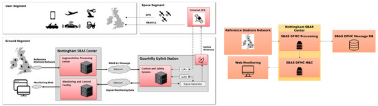
Figure 1.
UKSBAS Testbed architecture for UKSBAS L1 (left) and UKSBAS DFMC (right) processing chains.
2.2. Ground Segment
The ground segment consists of all elements that are necessary to generate SBAS messages and send them to the satellite for broadcast. The main elements are the reference station network (for the acquisition of GNSS reference data), the Augmentation Processing Centre (APC) for generating the SBAS messages, and the Uplink Infrastructure for sending the SBAS messages to the space segment for broadcast.
The Testbed approach for the acquisition of reference data uses existing CORS stations that have already been deployed. Two networks have been used: Ordnance Survey stations within the UK and IGS stations outside the UK landmass. A regional station network has been chosen for SBAS L1 provision to ensure ionospheric monitoring and a worldwide network for the iono/free SBAS DFMC provision, shown in Figure 2.
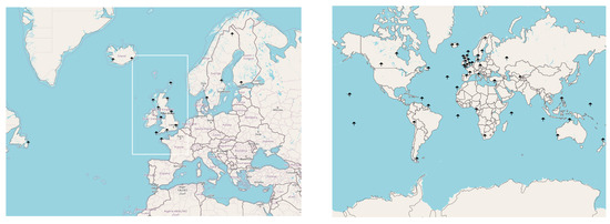
Figure 2.
Reference station networks chosen to compute SBAS L1 (left, also showing the service area) and SBAS DFMC (right) messages.
The Testbed elements that generate the SBAS messages are located at Nottingham. The Augmentation Processing Centre (APC) is responsible for processing the measurements received from the reference stations in order to compute the SBAS corrections and integrity information (UDRE/DFRE and GIVE) and formulate the SBAS messages to be transmitted according to applicable standards [2,3]. This process is carried out using GMV’s product magicSBAS. SBAS L1 and SBAS DFMC messages can be provided in real time over the Internet using the SISNeT Protocol [4].
Finally, the SBAS L1 messages are transmitted to the Uplink Infrastructure located at Goonhilly, South West UK. Among other elements, the Uplink Infrastructure utlises a signal generator controller (SIGGEN) that generates the electromagnetic signal, a GMV Signal Generator Controller (SGC) that allows command, control, and monitoring of SIGGEN, and a Full Motion Antenna (FMA) operated by Goonhilly Earth Station that transmits the signal to the Viasat/Inmarsat-3F5 satellite transponder for dissemination. Another important safety-related component is GMV’s Uplink Safety Monitor (USM), which checks the intended transmission to align with the applicable safety standards (i.e., ensuring MT0 broadcast at least once every 6 s).
2.3. Space Segment
The UKSBAS Testbed space segment consists of the Viasat/Inmarsat-3F5 geostationary satellite and its transponder payload that is used to broadcast the UKSBAS L1 Testbed signal over its footprint. Viasat operates this spacecraft and supports the signal uplink with TLE navigation parameters that support the uplink antenna orientation and signal control.
2.4. Support Segment
Lastly, the UKSBAS Testbed includes a subsystem that operates, maintains, and monitors the health of the whole system. The real-time performances are continuously monitored using magicMonitor, a browser front-end under the uksbas.org domain that displays information such as the real-time SIS broadcast and reference receiver status and instantaneous service availability maps.
3. UKSBAS Performance Assessment
3.1. Signal-in-Space Availability
The Signal-In-Space availability has been calculated as the ratio of PRN 158 SBAS messages logged by the Long Loop Receiver in Goonhilly Uplink Station, one of the control receivers involved in the Signal Controller subsystem, over the total broadcast timeframes. It is shown in Table 1.

Table 1.
UKSBAS L1 Testbed SIS Availability at Goonhilly Uplink Station.
Testbed signal outages have been experienced due to a variety of causes, which are now well-characterized and relate to the uplink antenna tracking capability in combination with the orbital inclination of the 3F5 vehicle located at 54° W (it is currently in an inclined orbit of more than 6 degrees due to its operational age). The spacecraft elevation, as seen at Goonhilly, varies between 12 and 22 degrees. As a consequence, the Long Loop Receiver periodically loses track of the SBAS signal over time. Other outage occurrences are related to planned maintenance at the APC, Goonhilly, and the Internet network provider. Nevertheless, the high broadcast availability proves the capacity of the spacecraft to support SBAS provision over the UK.
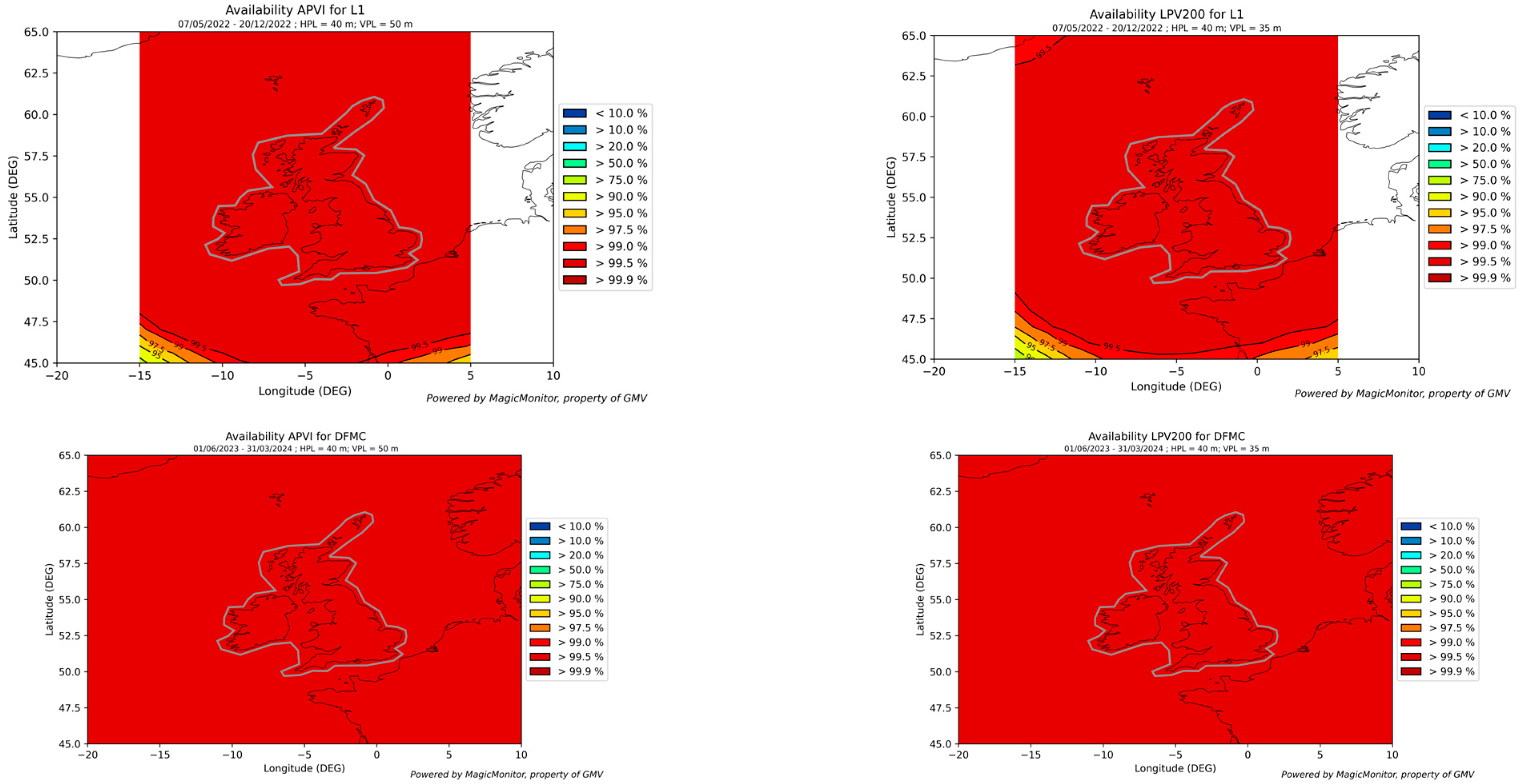
3.2. Service Volume Availability
The service volume availability measures the percentage of time at each point in an area where the user-level integrity (the protection levels) meets the service level requirements for Horizontal and Vertical Alert Limits (HAL, VAL). Figure 3 shows the cumulative measured availability for APV-I service level (HAL = 40 m and VAL = 50 m) and LPV-200 (HAL = 40 m and VAL = 35 m) in the UKSBAS service area computed by GMV Eclayr tool at the message generation level, without accounting for broadcast outages. The system successfully meets operational performance levels (over 99.9%) in terms of availability during the Testbed duration.
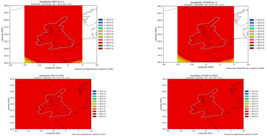
Figure 3.
Measured APV-I (left) and LPV-200 (right) cumulative availability of UKSBAS L1 solution (top) and UKSBAS DFMC solution (bottom) over the Service Area during Phase 2A.
3.3. Accuracy
The accuracy of the service can be assessed at different levels of the solution: at the satellite level (accuracy of the correction) and at the user position level.
At the satellite level, the correctness of the satellite orbit and clock corrections are evaluated by comparison with reference orbits and clock products from IGS [5].
Figure 4 presents the satellite residual error statistics for all satellites evaluated at the Worst User Location of the UKSBAS service area during Phase 2A. The data are presented in the shape of histograms, on a logarithmic scale to account for the distribution tails, and on Q-Q plots to facilitate the comparison with a folded normal distribution with the estimated mean and standard deviation computed from the empirical data.
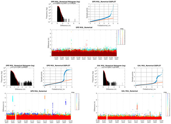
Figure 4.
Satellite residual error at the worst user location for UKSBAS L1 (left) and UKSBAS DFMC for GPS (middle) and GAL (right) constellations.
Note that in the case of SBAS DFMC, satellites E14 and E18 from the Galileo constellation have been excluded from the satellite accuracy analysis of UKSBAS DFMC, as they are deployed in eccentric orbits and present significant differences from the core constellation. The 95% ranging accuracy values at WUL were 85 cm for UKSBAS L1 GPS corrections and 76 cm and 54 cm for UKSBAS DFMC GPS and GAL corrections, respectively.
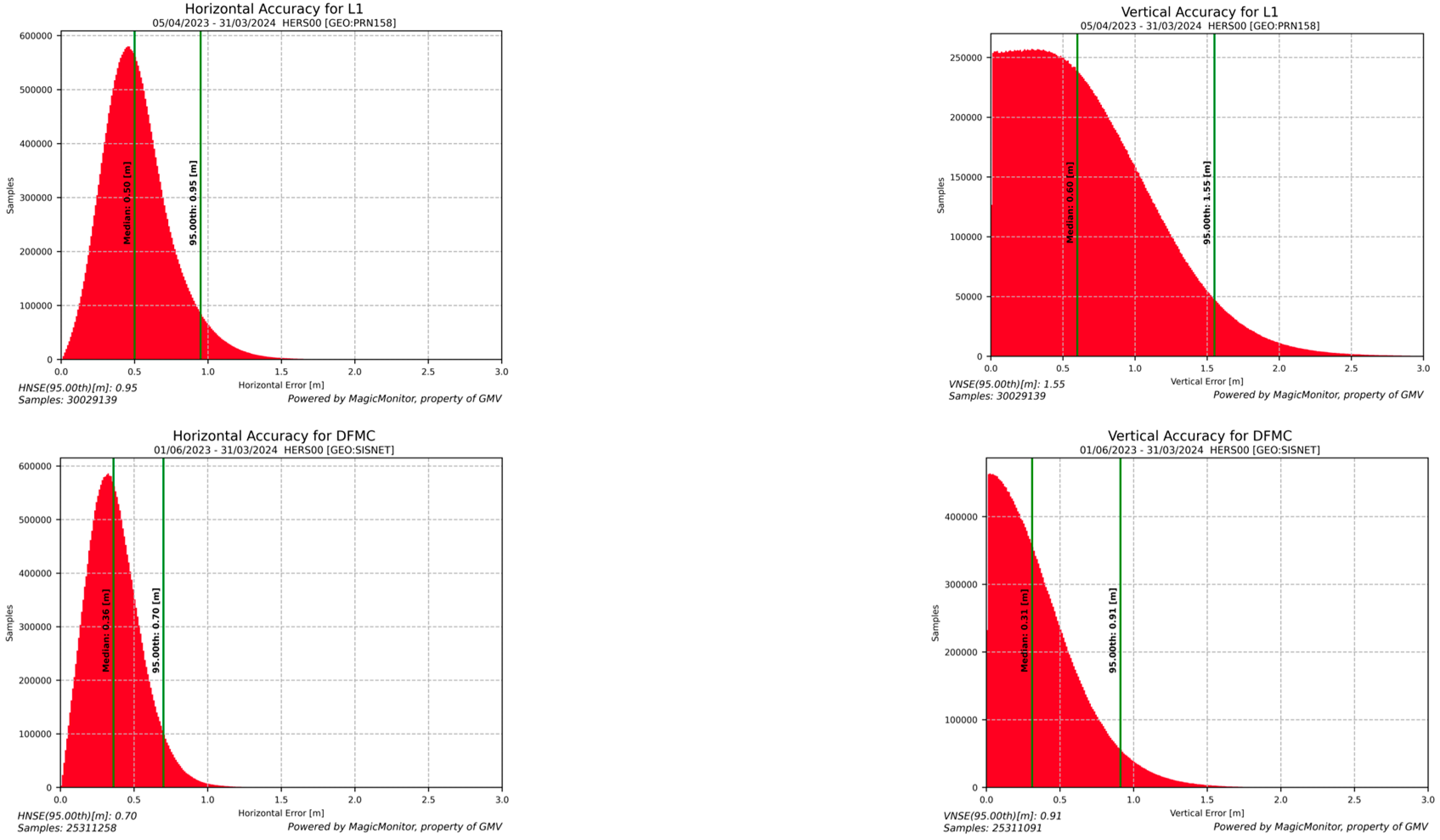
To assess the accuracy of the user position level, GNSS data from the HERS station (located in the southern UK) were processed using GMV’s magicGEMINI tool to compute UKSBAS user-level solutions. SBAS L1 and DFMC solutions were computed using the broadcast UKSBAS L1 messages received at the Uplink Station and the UKSBAS DFMC messages from the Augmentation Processing Center. Figure 5 shows the position error histograms in the horizontal plane and the vertical axis (in absolute value) for the whole applicable duration of Phase 2A, respectively. The improvement in SBAS DFMC solution in terms of more available satellites and removal of a high percentage of the ionospheric error translates into sub-meter accuracy levels (95% values 70 cm and 91 cm in horizontal and vertical projection, respectively), which is a significant improvement compared to SBAS L1 values, at 95 cm and 1.55 m, respectively.
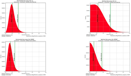
Figure 5.
Horizontal (left) and vertical (right) position error histograms of HERS station position with UKSBAS L1 (up) and UKSBAS DFMC (down) solutions.
4. UKSBAS Testbed Aviation Trials
The aviation trials were aimed at assessing UKSBAS user-level performance in different aviation environments using standard RTCA algorithms [2]. Data were collected from both static and dynamic aviation environments across various locations in the UK.
4.1. Static Aviation Trials: Airports Study
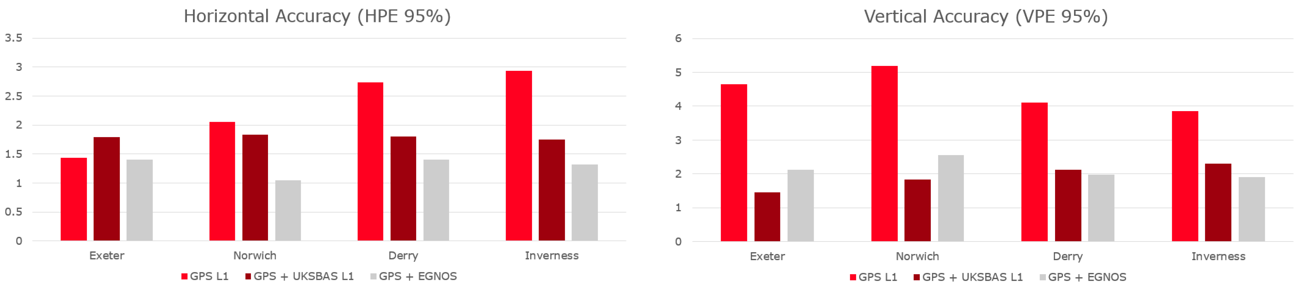
Static data collections have been carried out at four different airports to showcase the performance of the SBAS signal at the geographic boundaries of the UK for approximately 2 weeks per airport: north (Inverness, in the Scottish Highlands), south (Exeter, in the county of Devon), west (Londonderry, in Northern Ireland) and east (Norwich, in the county of Norfolk). Septentrio AsteRx SB receivers were employed, connected to Septentrio PolaNt-x antennas located in their respective local airports to assess the performances that surrounding landing aircraft would be able to achieve with augmentation, such as APV-I and LPV-200 services.
The Signal-In-Space availability, presented in Table 2, is calculated as the percentage of epochs the receiver logged PRN 158 SBAS messages over the scenario duration. The signal reception was successful in the Exeter and Inverness trials while building obstruction degraded the solution partially (Derry) or fully shadowed the GEO signal (Norwich).
Table 2.
Signal-In-Space availability per airport.
Due to the issues with the obstruction of the GEO SIS in some of the locations and not representative of the actual airborne environment, the L1 SBAS messages were added during the post-processing of the data. Natural Resources Canada (NRCAN) Precise Point Positioning (PPP) service [6] was used to obtain the receiver reference position for all the static trials and derive the position error. The performance analysis shown in Figure 6 indicates that UKSBAS L1 solutions outperformed standalone GPS L1 solutions in most cases by leveraging ionospheric and satellite corrections. Notably, the accuracy achieved by the UKSBAS L1 solution is comparable to that of EGNOS PRN 136 augmentation, despite UKSBAS being a non-operational testbed.

Figure 6.
Comparison of 95% horizontal and vertical position error statistics of airports.
The SBAS protection levels were studied to assess the availability performance of the system at the user level.
The processed solution was compared against LPV-200 operational requirements (HAL = 40 m, VAL = 35 m). In all the locations, the protection levels achieved post-processing were compatible with APV-I and LPV-200 requirements.
4.2. Dynamic Trials
The dynamic aviation trials collected GNSS data from onboard an aircraft, processed it using different solutions, and compared the results to show the performance improvement that can be achieved with UKSBAS.
The UKSBAS team has collaborated with Isles of Scilly Skybus to collect data from several flights between St. Mary’s airport, Land’s End, and Newquay, using a handheld Garmin 66r GNSS receiver placed close to the cockpit windshield of a De Havilland Twin Otter aircraft. As this demonstration configuration is not appropriate for an operational airborne SBAS in terms of environmental quality, the results achieved are not representative and are not further discussed in this paper.
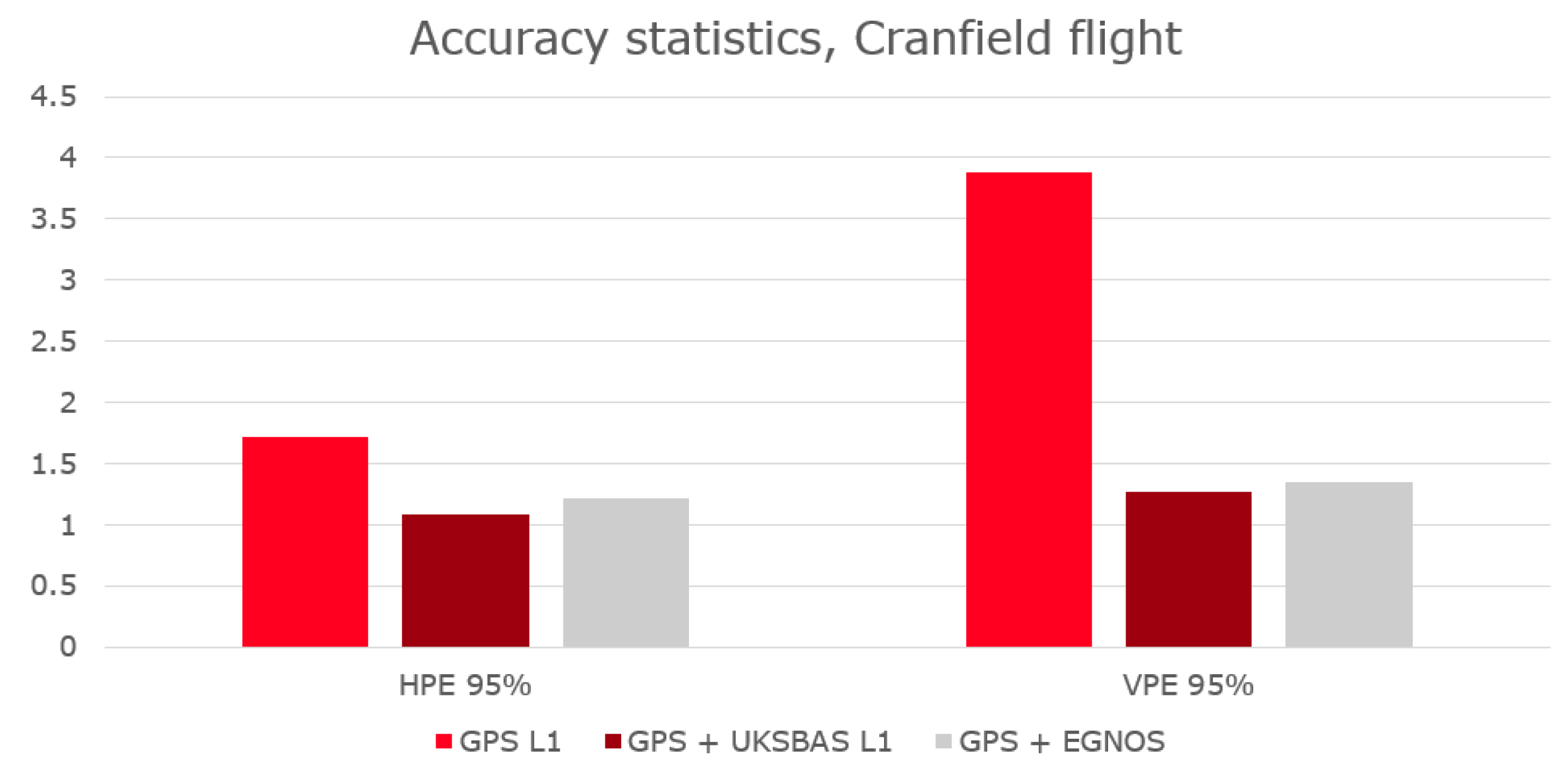
Additionally, the UKSBAS team, supported by PildoLabs Ltd., undertook end-to-end flight trials/demonstrations using a Saab 340 aircraft at Cranfield, UK, with the engagement of aviation stakeholders. Figure 7 show the performance achieved with data collected on the 24th of October. In the flight under analysis, PRN 158 was tracked 93% of the time.

Figure 7.
Comparison of 95% horizontal and vertical position error statistics from the Cranfield flight trial.
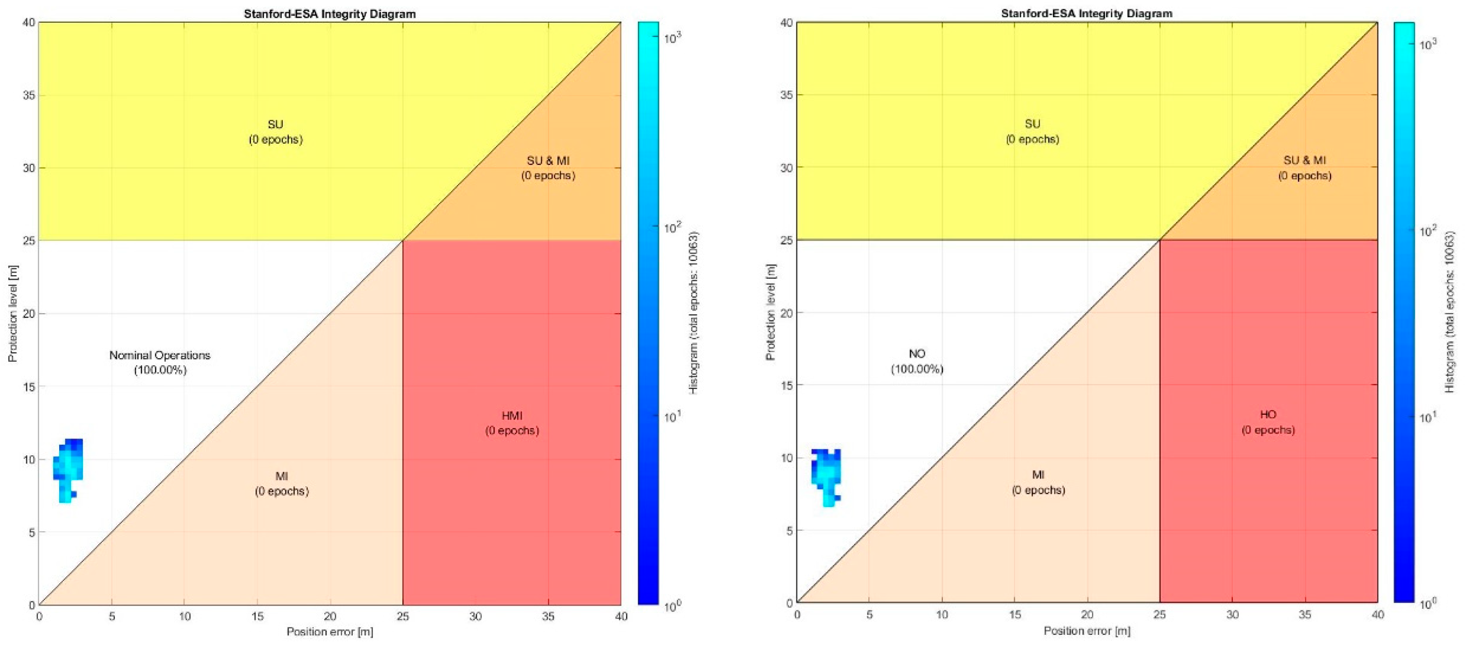
It is observed that the UKSBAS L1 solution improved the accuracy over standalone GPS L1, matching EGNOS 136 performances. On the other hand, the results showed horizontal and vertical protection levels below the corresponding LPV-200 alert limits, ensuring the availability of the service.
5. UKSBAS Testbed Maritime Trials
5.1. Maritime Trials Overview
The objective of the maritime trials was to assess the user-level performance of the UK SBAS Testbed in a maritime environment through analysis of maritime-adapted solutions with legacy SBAS (UKSBAS L1 Testbed and EGNOS) and DFMC SBAS (UKSBAS DFMC via post-processing). In the simplest case, the standard aviation equations are used, but with a modified multipath model, to account for the fact that multipath errors are higher in the maritime domain. In the second case, a further change is made whereby maritime-specific sigma UDRE and GIVE values are used instead of the nominal values broadcast in the SBAS messages. These maritime-specific values are generated as part of the Maritime Integrity Support Facility (MISF), which was created as a dedicated maritime service as part of the Testbed to provide maritime-specific integrity information instead of the broadcast aviation values through Maritime Integrity Support Interface (MISI) messages.
The maritime trials involved the deployment and operation of SBAS-enabled equipment on the Scillonian III, a vessel undertaking routine passenger services operated by the Isles of Scilly travel and traveling between Penzance, Cornwall, and St Mary’s, Isles of Scilly, see Figure 8. The deployed equipment computed and logged real-time GPS L1 + SBAS solutions using the broadcast UK SBAS signals, recorded raw GNSS measurements, and received SBAS messages for post-processing. The equipment was installed on the vessel for 3 days, covering three return trips from Penzance to St Mary’s.

Figure 8.
Overview of the Scillonian III vessel route during 27–29 June 2023.
5.2. Maritime Trials Performance Assessment
For user-level performance, the recorded data were post-processed in different modes, and the estimated positions were compared with a reference solution (generated using RTKlib in PPK mode relative to CORS reference sites).
The mean 95% horizontal position accuracy values from the different trials are shown in Figure 9. The results show the comparative benefits of UKSBAS integration into positioning systems compared to relying on standalone GPS L1 signals. Furthermore, the GPS + Galileo dual-frequency multi-constellation configuration achieves a 95% horizontal accuracy of approximately 1 m.
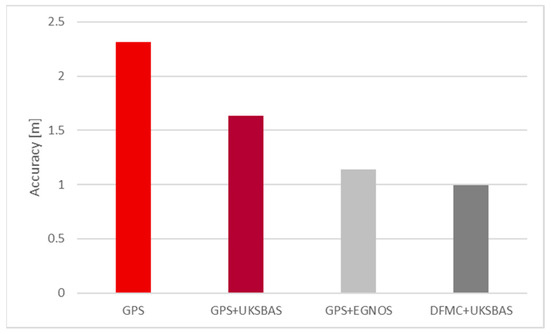
Figure 9.
95% values of horizontal position error for different positioning solutions.
The effect of MISI messages on accuracy performance is minimal since the differential corrections are not changed through the MISI messages—only the sigma values are changed. However, we see some impact on the protection levels since the MISI sigma values are smaller. Therefore, the weightings for all satellites (and hence total protection levels) are reduced whilst still maintaining the bounding of the position errors. As an example, Figure 10 shows the horizontal position errors vs. HPL for the 29 June am journey for GPS L1 + UKSBAS on the left and GPS L1 + UKSBAS + MISI on the right. Although there is not a large difference, it can clearly be seen that the protection levels for the MISI case are smaller.
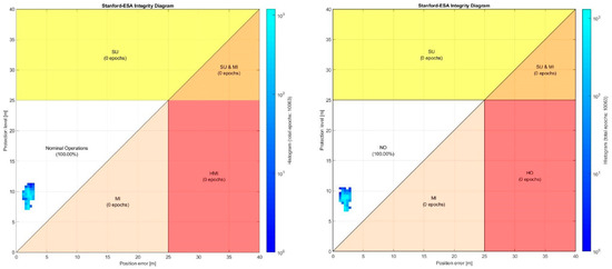
Figure 10.
95% Horizontal error vs. HPL for GPS L1 + UKSBAS (left) and GPS L1 + UKSBAS + MISI (right).
6. Conclusions
UKSBAS Testbed has been continuously broadcasting through the Viasat/Inmarsat 3F5 transponder for two years with outstanding performances. This paper reports the performances achieved during the Testbed operations, comprising the provision of SBAS L1 and SBAS DFMC augmentation aids. Additionally, the aviation and maritime trials showcase the effectiveness of the system in providing a valuable solution to the transport sector in the UK.
Author Contributions
Conceptualization, J.G.M., F.B.L. and M.P.; methodology, J.G.M., F.B.L. and M.P.; software, J.R.C.H., I.S.P., M.I.R.L. and S.P.I.; validation, J.R.C.H., I.S.P., M.I.R.L. and S.P.I.; formal analysis, J.R.C.H., I.S.P., M.I.R.L. and S.P.I.; investigation, J.G.M.; resources, F.B.L. and M.P.; data curation, J.R.C.H., I.S.P., M.I.R.L. and S.P.I.; writing—original draft preparation, J.G.M., M.I.R.L. and S.P.I.; writing—review and editing, J.G.M., F.B.L., M.P., M.E. and D.H.; visualization, J.R.C.H., I.S.P., M.I.R.L. and S.P.I.; supervision, J.G.M., F.B.L., M.P. and D.H.; project administration, M.E. and G.N.; funding acquisition, D.H. All authors have read and agreed to the published version of the manuscript.
Funding
This research was funded by the European Space Agency (ESA) Navigation Innovation and Support Programme (NAVISP) Element 3 project NAVISP-EL3-025 “UKSBAS”, which was led by Viasat (ESA Contract No: 4000139927/22/NL/WC).
Institutional Review Board Statement
Not applicable.
Informed Consent Statement
Not applicable.
Data Availability Statement
Data sharing is not applicable to this article.
Acknowledgments
The authors wish to acknowledge the support given by UK authorities, UKSA and Department for Transport, and ESA in the conduction of these activities, as well as Isles of Scilly Travel, Skybus, Isles of Scilly Steamship Group, Highlands and Islands, Cranfield University, and RCA.
Conflicts of Interest
Authors J.G.M., F.B.L., M.P., M.E., J.R.C.H., I.S.P., M.I.R.L. and S.P.I. were employed by the company GMV. Authors D.H. and G.N. were employed by the company Viasat. The authors declare that this study received funding from ESA NAVISP Element 3. The funder had the following involvement with the study: review and authorisation.
References
- Hill, D.; Newton, G.; Soddu, C.; Dumville, M.; Easom, M.; Tiwari, S.; Roberts, W.; Lerma, J.B.; Pericacho, J.G.; Emes, C. A United Kingdom Space-Based Augmentation System Testbed Capability. In Proceedings of the 35th International Technical Meeting of the Satellite Division of The Institute of Navigation (ION GNSS+ 2022), Denver, CO, USA, 19–23 September 2022; pp. 714–724. [Google Scholar] [CrossRef]
- DO-229C; Minimum Operational Performance Standards for Global Positioning System/Wide Area Augmentation System Airborne Equipment. RTCA Inc.: Washington, DC, USA, 2001.
- ED-259; Minimum Operational Performance Standards for Galileo—Global Positioning System—Satellite-Based Augmentation System Airborne Equipment. EUROCAE: Saint-Denis, France, 2019.
- SISnet. Available online: http://www.egnos-pro.esa.int/sisnet/index.html (accessed on 8 May 2024).
- NRCAN. PPP. Available online: https://natural-resources.canada.ca/maps-tools-publications/data (accessed on 8 May 2024).
- CDDIS. Products. Available online: https://cddis.nasa.gov/Data_and_Derived_Products/GNSS/orbit_products.html (accessed on 8 May 2024).


Disclaimer/Publisher’s Note: The statements, opinions and data contained in all publications are solely those of the individual author(s) and contributor(s) and not of MDPI and/or the editor(s). MDPI and/or the editor(s) disclaim responsibility for any injury to people or property resulting from any ideas, methods, instructions or products referred to in the content. |
© 2025 by the authors. Licensee MDPI, Basel, Switzerland. This article is an open access article distributed under the terms and conditions of the Creative Commons Attribution (CC BY) license (https://creativecommons.org/licenses/by/4.0/).