1. Introduction
Understanding the extent and location of snow cover is crucial for advancing our knowledge of current and future climate conditions, the hydrological cycle, and ecological dynamics, both at local and global scales [
1]. Snow-dominated regions serve as important reservoirs during the melting period, contributing significantly to the hydrological system [
2,
3]. Additionally, their high albedo and thermal properties have a profound impact on the surface energy balance [
4].
The variability of snow cover across seasons plays a critical role in comprehending regional climate patterns, hydrological processes, and the overall energy balance. The precise monitoring of the snow cover extent and its properties provides valuable insights into Earth’s climate dynamics, the hydrological cycle, and energy considerations, which are vital for effective water resource management and informed infrastructure planning. Moreover, the influence of snow cover on economies, ecosystem functionality, and the occurrence of natural disasters highlights its significance as a primary source of drinking water supply.
Remote sensing methods offer a convenient and powerful means of observing and tracking snow cover extent and parameters, particularly in challenging mountainous and inaccessible regions. The European Organization for the Exploitation of Meteorological Satellites (EUMETSAT) is an intergovernmental organization committed to monitoring weather, climate, and the environment from space. It operates a fleet of meteorological satellites and provides valuable data and services to the global meteorological community. One notable initiative led by EUMETSAT is the Hydrology Satellite Application Facility (H-SAF) project, dedicated to the development and provision of satellite-based products and services specifically tailored for hydrological applications.
H-SAF utilizes the Spinning Enhanced Visible and Infrared Imager (SEVIRI) and other satellite instruments to generate a wide range of products, including precipitation, soil moisture, and snow cover. These products offer accurate precipitation estimates from Meteosat Second Generation (MSG) and valuable information about soil moisture dynamics. The snow products provide insights into temporal and spatial snow cover extent, aiding in the understanding of snow accumulation and melting patterns.
The H-SAF Snow Extent Europe SEVIRI (hereafter, H10) product, retrieved from MSG SEVIRI, utilizes the high reflectivity of snow in the visible spectrum and the comparatively low reflectivity at shorter wavelengths [
5]. By leveraging these characteristics, the H10 product effectively captures and characterizes the presence and extent of snow cover in the observed region.
The primary objective of this study is to utilize the H10 product to analyze and present crucial insights into the monthly and seasonal spatial variability of snow cover extent over a specific area in the southern Balkans region. The study focuses on examining the snow cover extent for the past five years, from 2022 to 2018, aiming to understand the temporal patterns and changes in snow cover during the cold season (autumn and winter).
Section 2 of the study encompasses the data and methodology employed in the research. This section provides an overview of the data sources utilized.
Section 3 presents the results obtained from the study and the subsequent analysis. A summary and conclusion of the study are included in
Section 4.
2. Data and Methodology
The H10 product is an operational daily snow extent product derived from the visible (VIS) and infrared (IR) radiometry data captured by the SEVIRI instrument on board the geostationary MSG satellites and covers the area between 25–75° N latitude and 25° W–45° E longitude. These channels are selected for their contribution to snow and cloud detection and discrimination between the two of them. In addition, multi-temporal analysis, in which consecutive pixels may have a different observation time, is performed to acquire a clearer view of snow-covered terrain. The use of SEVIRI imagery, with its high temporal resolution and wide coverage, is particularly advantageous for snow-cover mapping as it allows for continuous monitoring of cloud cover [
6,
7].
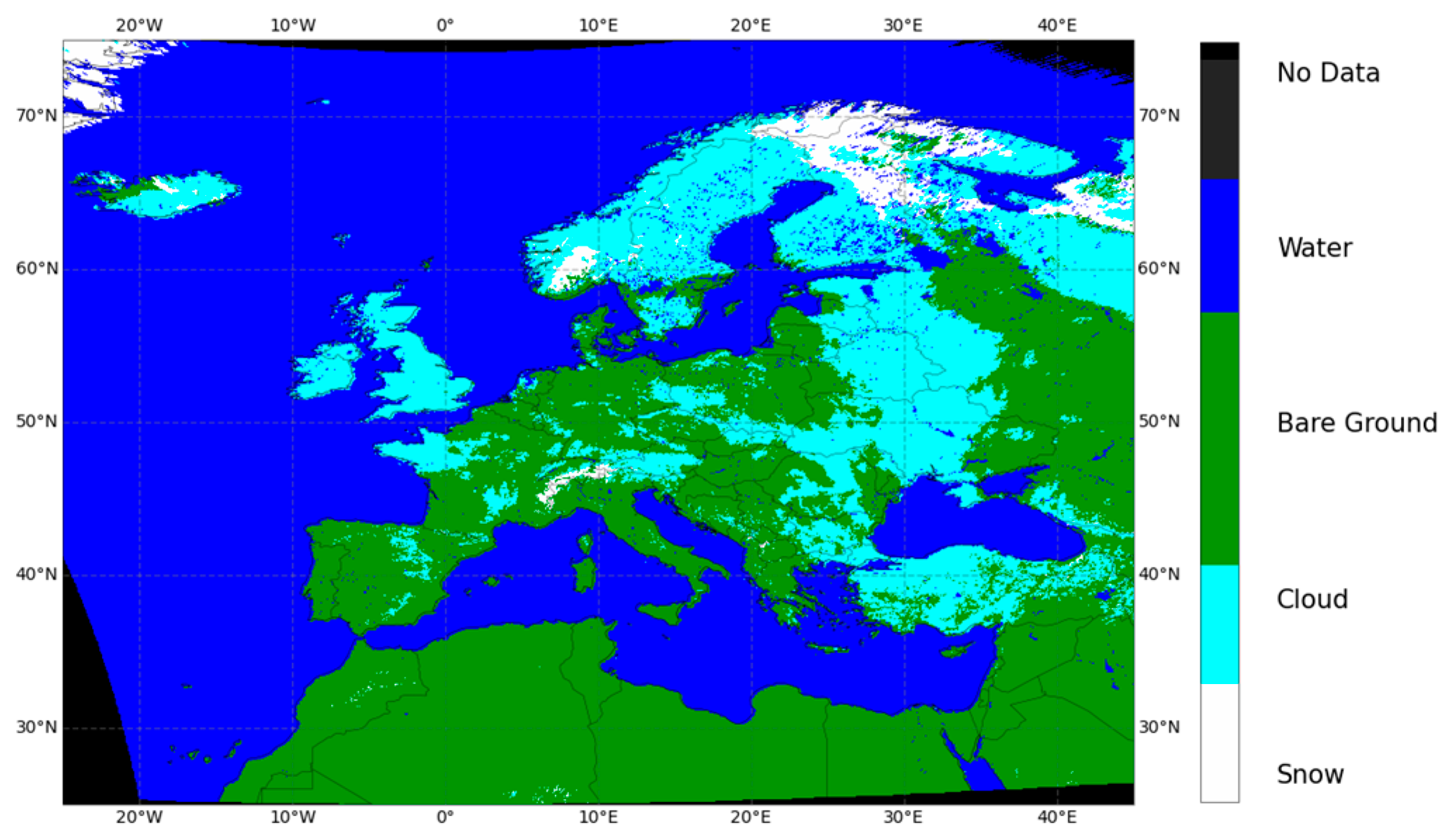
The H10 daily snow cover product is generated by analyzing a series of SEVIRI 15 min images, employing a multi-temporal approach to collect a maximum number of cloud-free pixels. The sampling is conducted at 3 km intervals, which degrade to approximately 5 km over Europe [
5,
8,
9]. The resulting daily map encompasses the spatial coverage between longitude 25° W to 45° E and latitude 25° N to 75° N, the map represents four distinct classes: snow, cloud, water, and bare ground, as illustrated in
Figure 1.
The study area, which encompasses parts of the southern Balkans, is defined by its geographical coordinates ranging from 41.30° N to 39.80° N latitude and 19.50° E to 26.00° E longitude. This area includes the southern portions of Albania and North Macedonia, as well as the northern parts of Greece, as depicted in
Figure 2. The figure highlights the notable diversity of the terrain within the study area, featuring mountainous regions, bodies of water such as seas and lakes, and forested land areas.
In order to accommodate the diverse characteristics of snow in mountainous and flat areas, the production of snow products utilizes two distinct algorithms. One algorithm is specifically tailored for flat areas, while the other is designed to handle the complexities of mountainous terrain [
5,
6,
7,
8,
9,
10]. These algorithms employ different methodologies and parameters to accurately retrieve snow-related information in their respective regions. Once the snow products are generated using separate algorithms, they are merged together to create a unified and comprehensive snow product that incorporates data from both flat and mountainous areas [
6,
7]. This merging process ensures a comprehensive representation of snow cover, taking into account the unique characteristics and conditions of each terrain type.
Consequently, the climate in this area is influenced by various factors. The coastal regions adjacent to the Adriatic, Ionian, and Aegean seas exhibit a Mediterranean climate (Csa). The southern inland areas have a humid subtropical climate (Cfa), while the northern inland regions have a humid continental climate. The areas bordering these climates exhibit semi-arid conditions (Bsk and Bsh). Moreover, the high mountain ridges are predominantly characterized by a subarctic climate (Dfc) [
11].
The analysis in this study was performed using H10 data collected over a five-year period from 2018 to 2022. The data covered the autumn months (September, October, and November) and winter months (December, January, and February) during each year within the specified timeframe.
The classification of each pixel within the H10 dataset refers to a specific coordinate point and includes categories such as no-data, water, bare ground, cloud, and snow cover. These classifications are represented within the H10 product in the snow cover (SC) dictionary of the file. The SC dictionary maintains a consistent mapping with the LAT (latitude) and LONG (longitude) dictionaries within the hdf5 file. As a result, the row and column numbers for a particular pixel of snow cover data correspond directly with the latitude and longitude arrays, ensuring accurate spatial alignment.
Prior to classifying the data into months and seasons, each HDF5 file, representing a single day, underwent separate processing to extract the cloud and snow data for each pixel. The classification of hdf5 files into months and seasons was achieved by utilizing the information encoded in the file names. Subsequently, the extracted cloud and snow data for each pixel from the classified files were merged through addition and saved. As a result, two values were stored for each pixel, representing the total number of days with snow cover and cloud cover during the study period.
To obtain more accurate results, the proposed method involved calculating the average number of days with snow cover for each pixel. This calculation was performed by dividing the total number of days with snow cover by the total number of days in the study period, excluding the days with cloud cover. This is expressed by the following Equation (1):
The purpose of this calculation was to account for the influence of cloud cover on the accurate determination of the average number of days with snow cover for each pixel.
3. Results and Discussion
The analysis in this study focused on seasonal data, specifically autumn and winter. The data was processed and analyzed for these two seasons, allowing for a comprehensive understanding of the snow cover dynamics during these periods. By narrowing the analysis to autumn and winter, the study aimed to capture the seasonal variations and patterns in snow cover extent and properties, which are particularly relevant for climate, hydrological, and ecological studies.
During the autumn season, the average number of days with snow cover is relatively low, with the maximum number of days accounting for less than 7% of the total clear sky duration (
Figure 3). Notably, the northwest part of the study region, specifically the area of southern Albania, experiences a higher frequency of snow cover compared to the eastern parts. Western regions, in general, demonstrate a higher susceptibility to snow cover during autumn.
It is observed that snow cover exhibits higher persistence primarily over mountain ridges. This indicates that mountainous areas tend to retain snow cover for longer durations, even during the autumn season. The persistence of snow cover over mountain ridges can be attributed to factors such as colder temperatures, higher elevations, and the sheltering effect provided by the terrain. Overall, these findings highlight the spatial variations in snow cover during the autumn season, with western regions and mountainous areas exhibiting a greater likelihood and persistence of snow cover compared to eastern parts of the study region.
The mean monthly results of the analysis (not shown), specifically focusing on the extent of snow cover during September, October, and November, reveal that the snow cover extent is relatively limited in the study region during these months. The duration of snow cover is also shorter during this period. On average, the maximum number of days with snow cover stays below 3% for September, 5% for October, and approximately 16% for November. These findings suggest that the occurrence of snow cover in the study region during September, October, and November is relatively infrequent and of shorter duration compared to other months.
During the winter season, the distribution of snow cover across the study area is more extensive compared to the autumn season (
Figure 4). This indicates a higher consistency and wider coverage of snow during winter. Moreover, there is a greater maximum number of days with snow cover during winter compared to autumn, indicating that snow persists for a longer duration in the winter season.
In specific instances, the number of days with snow-covered terrain remains slightly below 80% of the total clear sky duration. This is particularly prominent over mountain ridges, where snow cover shows the highest level of persistence. The mountainous regions, characterized by higher elevations and colder temperatures, contribute to the sustained presence of snow cover.
Similar to the findings in autumn, there is a regional variation in the susceptibility to snow cover during winter. With the exception of a western area of Albania, where the average number of snow-covered days is notably low, the western parts of the study region generally exhibit a higher susceptibility to snow cover compared to the eastern parts. This discrepancy can be attributed to variations in elevation, climate patterns, or other geographical factors.
Overall, these observations underscore the contrasting snow cover dynamics between autumn and winter. Winter experiences a more widespread and longer-lasting snow cover, with mountainous regions playing a pivotal role in its persistence. Additionally, the regional variability in snow cover susceptibility aligns with the findings from the autumn analysis.
The mean monthly analysis of snow cover during the winter season, specifically for December, January, and February from 2018 to 2022, indicates a significantly longer duration compared to the autumn months. The maximum average number of days with snow cover surpasses 80% for December and January, while it reaches around 70% for February. This highlights the increased presence and persistence of snow cover during these winter months.
January and February, which align with the period of higher probability of snowfall according to the region’s climatology, exhibit a higher quality of snow cover distribution compared to the autumn months. The snow cover is more consistent and widespread during this period, indicating a higher overall snowfall accumulation. Additionally, the snow cover demonstrates greater persistence, indicating its ability to withstand melting and maintain its extent for longer periods.
These findings underscore the importance of January and February as the peak winter months with the highest likelihood of snowfall. The winter mean monthly analysis reveals an enhancement in snow cover duration, quality, and persistence during this period, offering valuable insights into the winter climate patterns and snow dynamics within the region.
4. Conclusions
Understanding snow cover extent and location is vital for advancing knowledge of climate, hydrology, and ecosystems at various scales. Snow-dominated regions act as reservoirs during melting, affecting the hydrological system, energy balance, and water resource management. Remote sensing, exemplified by EUMETSAT’s H-SAF project, enables monitoring of snow cover using satellite data, such as SEVIRI, to generate products including precipitation, soil moisture, and snow cover. This study focuses on the H10 product to analyze the spatial variability of snow cover over the past five years in the southern Balkans.
The analysis focused on the seasonal dynamics of snow cover, revealing variations between autumn and winter. During autumn, snow cover is limited, with the highest average number of days below 7%. Mountainous areas exhibit higher persistence of snow cover. Winter; however, experiences more extensive snow cover with longer durations. January and February have the highest probability of snowfall, resulting in higher quality and persistence of snow cover compared to autumn. Snow cover extent in winter exceeds 80% for December and January, and around 70% for February. Overall, winter showcases greater snow cover extent, duration, and quality compared to autumn.


 ,
, 