Article

Risk Assessment in Landslide-Prone Terrain within a Complex Geological Setting at Kadugannawa, Sri Lanka: Implications for Highway Maintenance

by
Sunera Mahinsa Pitawala
1,
Harindu Wimalakeerthi
1 and
Thomas Heinze
2,*
1
Department of Civil Engineering, Faculty of Engineering and Technology, CINEC Campus, University of Wolverhampton, Millennium Drive, IT Park, Malabe 10115, Sri Lanka
2
Department of Hydrogeochemistry and Hydrogeology, Institute for Geology, Mineralogy and Geophysics, Ruhr University Bochum, Universitätsstraße 150, 44801 Bochum, Germany
*
Author to whom correspondence should be addressed.
Geotechnics 2024, 4(2), 564-580; https://doi.org/10.3390/geotechnics4020031
Submission received: 28 April 2024 / Revised: 31 May 2024 / Accepted: 6 June 2024 / Published: 8 June 2024
(This article belongs to the Special Issue Recent Advances in Geotechnical Engineering (2nd Edition))

Abstract

:
The major highway in Sri Lanka that links the capital, Colombo, with the second capital, Kandy, passes through Kadugannawa, characterized by steep hills. The geological and geomorphological setting of the terrain often leads to slope failures. The objective of this study is to interpret the key factors influencing the slope failures that occurred in close proximity at two separate locations with two different slope conditions. Typical local and regional brittle and ductile structures include fault scarps, deep-seated detachments, and variable folding. According to our results, one of the studied locations experienced translational landslides because of weakened basement rock surfaces, hydrophilic clay minerals, and anthropogenic influences, whereas the other location experienced multiple stages of mass movement influenced by inhomogeneous colluvial soil and regional, geological, and hydrogeological conditions. Based on the present study, it can be concluded that geological studies must be carried out within the local area rather than at the regional scale. Otherwise, the constructions for the prevention of landslides in complicated geological settings will fail or may not be used for a long period. Moreover, consideration of future climate change is essential when undertaking construction in challenging terrains.

Graphical Abstract

1. Introduction

Landslides pose significant hazards globally, resulting in significant human and financial losses, especially in developing countries [1,2]. These natural slope failures are commonly caused by a combination of factors, such as heavy rainfall, storm water activities, geological and topographical conditions, geotechnical properties, seismic forces, and anthropogenic activities [3,4]. Human activities, particularly in construction areas such as roads and buildings, can also affect slope susceptibility when slope conditions are unknown [5,6]. However, the contribution of these factors varies, with specific factors affecting each landslide [7,8,9]. In general, the number of rainfall-triggered landslides is expected to increase, especially in tropical climates, due to climate change [10,11,12,13]. Bracko et al. (2022) [14] show that the change in precipitation patterns will especially impact soils of low permeability. However, including climate change effects as well as uncoordinated urban sprawl along slopes in landslide hazard assessments is challenging [15].
In the recent past, the intensity of natural disasters, including landslides, has increased in Sri Lanka [16]. Based on rainfall patterns and the frequency of landslide occurrences, an increase in landslides in Sri Lanka was observed over the last two decades [17,18], which may be attributed to climate change rather than human activities. According to estimates by Senanayake and Pradhan (2022) [19], soil erosion rates in the country are expected to increase by 4–22% compared to the erosion rate in 2020, indicating an increase in the rate of landslides.
Despite being a small island with a land area of 65,610 km2, Sri Lanka is characterized by diverse geomorphologic settings, even within short distances [20,21,22,23]. However, in Sri Lanka, detailed investigations of landslides or slope failures have generally been conducted over larger areas, rather than focusing on individual small failures that occurred in close proximity. Comparing regions with similar precipitation patterns in Sri Lanka and Japan, it was found that the topography has a strong impact on the spread and mobility of landslides in Sri Lanka [13]. Further factors influencing landslides or slope failures within a small area can vary due to a variety of reasons, such as variations in vegetation intensity, anomalies in soil texture, and different geological conditions, as well as anthropogenic influences such as slope cutting, the construction of poorly designed buildings, alterations in surface water flow paths, and changes in land use [24]. Among the factors mentioned above, human activities significantly contribute to inducing landslides, with a risk factor approximately five times higher than that in barren terrain [25]. However, a lack of trust in governmental actions, insufficient financial support and the fear of loss of income due to self-employment has limited relocation measures in Sri Lanka [26].
Since roads in Sri Lanka are the main transportation routes, they are a major requirement for socio-economic development. The highway road network of Sri Lanka covers all parts of the country and crosses several morphological settings, and the spread of the road network is about 119,000 km (Figure 1). Landslides frequently occur in hilly regions of the country during heavy rain periods and can affect the roads in certain areas. Sometimes, slope failure events occur through cutting slopes made for road construction and nearby construction, changing the natural hydrological and pedagogical conditions [27,28,29]. Such incidents seriously damage the country’s economic situation and result in the sudden loss of lives, environmental destruction, and the erosion of social integrity among poor people [30].
The Colombo–Kandy road, also referred to as the A1 road, links the capital (Colombo) and the second capital (Kandy) of the country. The road further extends towards the northern end of the island. In comparison to other roads in the country, this road provides significant facilities for the nation, as it is used not only for transporting passengers but also for delivering essential goods and materials to the people. The Colombo–Kandy railway track, which connects to other major cities located to the southeast of Kandy and in the hill country, also runs close to the highway at Kadugannawa. Landslides and slope failures have occurred frequently in the Kadugannawa area, causing significant damage in 2003, 2016 [31], and 2021 (the most recent failure). This may be attributed to the intense rainfall in recent years and the encroachment of dwellers and residences along the roadside with the aim of selling items to passengers and providing easy transportation for them. Due to the increasing population in the area, the natural setting has been altered. Due to the influence of anthropogenic activities associated with climate change, the occurrence of landslides is highly probable. Large-scale slides were not recorded in the area until 2016. Therefore, the landslide hazard was not present in the public perception. Sloping areas were covered for unauthorized constructions and small-scale cultivations, which led to the diversion of the natural water flow and alterations in slope angles. However, there is ample evidence of paleo-landslides that may have occurred long before the construction of the road. Some parts of the road were constructed on paleo-landslides. Past studies revealed that building and sustaining highways in regions with historical landslides, complex geological settings, and high-risk areas is an extremely difficult task [32,33].
Before implementing remedial measures for the damage that has occurred, the main causative factors must be clearly understood [34,35]. After this, appropriate geotechnical methods and soil treatment schemes should be proposed and implemented [36,37]. Therefore, risk analyses and assessments are essential tools for addressing the ambiguity characteristic of landslide hazards [38]. Landslide-prone hills have been identified by most districts [39] but, besides risk zoning, very few counter measures within Sri Lanka are specified in the literature [40]. In general, common counter measures and reinforcement designs include surface water management using drainage systems [14], the modification of slope geometry, reinforcement by soil nailing, or the installation of protective nets [41]. We observed drainage systems, retaining walls, and soil nailing as common geotechnical mitigation measures along roadsides in Sri Lanka. If possible, slope monitoring using various methods, such as tilt measurements [42], or even a combination of engineering [43] and/or geophysical [44] methods, can contribute to a site-specific early warning system. However, the large numbers of landslide-prone hills in Sri Lanka require low-cost solutions [45], such as that presented by Fang et al. (2024) [46]. The current landslide early warning system in Sri Lanka is primarily precipitation-based, with some site-specific early warning systems based on instrumentation and community observations [47].
Figure 1. (a) Climatic zones of Sri Lanka based on Punyawardena (2020) [48] with major cities and the national railway and highway network. (b) The two test sites along the Colombo–Kandy Road, close to Kadugannawa (satellite image by Google Maps 2024 Airbus/CNES). (c) Monthly precipitation and rainfall days of 2021 for the study area, with data taken from World Weather Online.
Geotechnics 04 00031 g001
The objective of this study is to interpret the key factors influencing the slope failures that occurred in close proximity on two separate slopes that developed (i) obliquely to a scarp slope of basement rocks with distinct soil characteristics and (ii) parallel to a steep escarpment. The findings of the current study demonstrate the high variability of the facilitating factors for landslides over short distances. Hence, our work provides indications for the required resolution of hazard mapping. Furthermore, our findings provide valuable insights to professionals working on highways or other related construction areas in challenging geological environments and recommend cost-effective, long-lasting measures to prevent slope failures.

2. General Setting of the Study Area

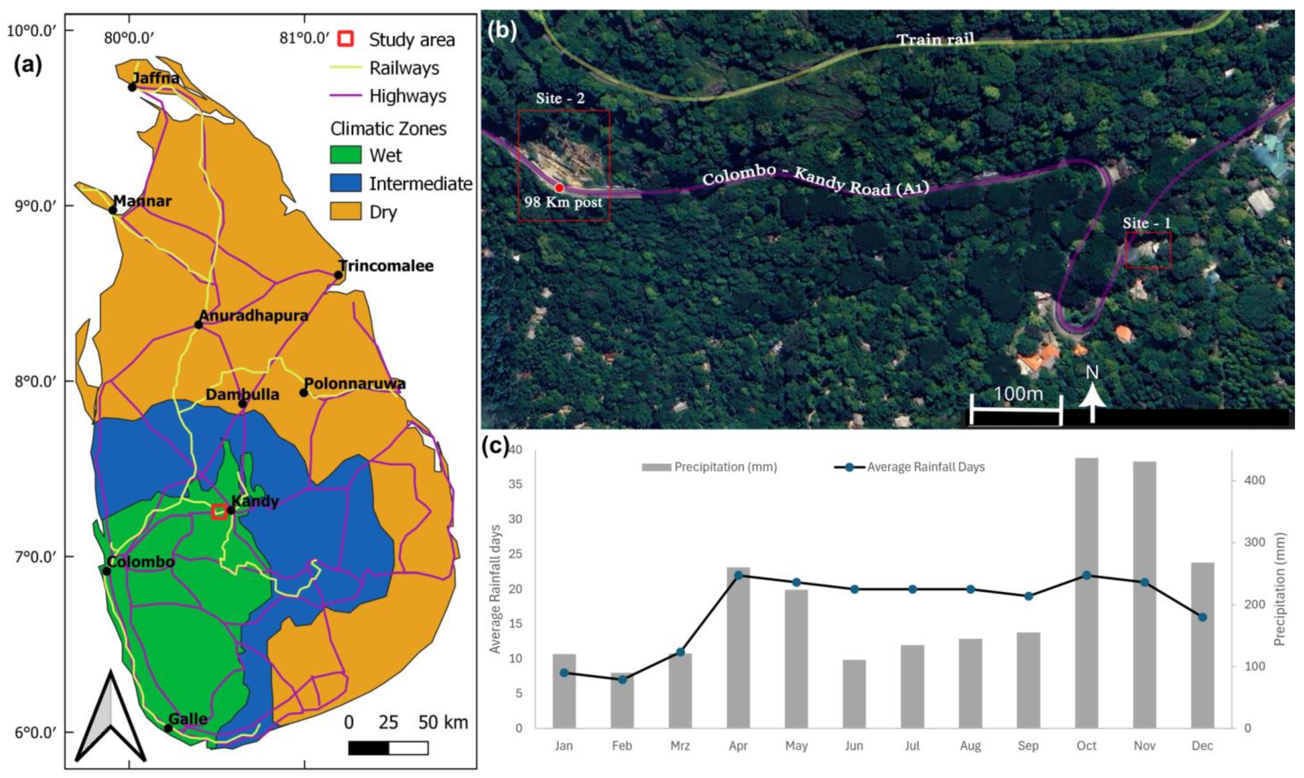
2.1. Climate, Geomorphology, and Vegetation

Sri Lanka is characterized by three main morphological regions—coastal lowlands (30–270 m), uplands (270–1060 m), and highlands (1060–2400 m)—based on their height and slope characteristics. The uplands and highlands exhibit a sequence of asymmetrical scarps or break-in-slopes, while the lowlands have several inselbergs [49]. The study area belongs to the uplands. The coordinates of the study area were 7°15′16″ N and 80°31′27″ E, with an elevation of 580 m above sea level. The study area has a tropical climate and receives rain even during the driest month in the country (Figure 1). The average annual temperature is 23.9 °C, and the annual precipitation is approximately 2266 mm. The most rainfall occurs during October and November (Figure 1c). Because temperature variation is minimal in the area, the hot and cold seasons cannot be distinguished as clearly as in other parts of the country.
From a climatological standpoint, the study area has a bimodal pattern in its annual rainfall, with significant peaks in October and November and a smaller peak in June. The relationship between the area’s hilly topography and seasonal variations in the country’s circulation has a significant impact on the distribution of rainfall across the area during the four seasons. The landslides occurred in November 2021 on the upper slopes of the Colombo–Kandy roads. High rainfall occurred on 2–3 November 2021, followed by intense rain from 8–10 November 2021, in the area. The total rainfall during these three days was more than 200 mm and the rain mostly occurred during late evening or the night. Land instability began at around the 98 km post on the road, and tension cracks developed on 10 November 2021, according to the National Building Research Organization (NBRO), Sri Lanka (https://www.nbro.gov.lk, Retrieved 25 November 2023). Slope failures with structural damage were reported in the area, mostly within two days of the rainfall.
The study area exhibits a ridge and valley topography characterized by highly dissected plateaus that have undergone intense erosion, as well as narrow and elongated doubly plunging synforms, along with north–south trending parallel rock exposures. Most rock slopes are relatively stable and well-developed steep scarps are common, particularly near the Colombo–Kandy highway and rail track. However, the areas located adjacent to rocky exposures at lower elevations are composed of colluvium deposits, making these areas highly vulnerable to land instability. The middle area of this synform is relatively flat and has an undulating or hummocky topography due to the basement geological conditions [49]. In moderately sloped areas, the slope angle varies greatly, with values ranging from 10 to 35°. A large-scale landslide occurred in the southern hilly area long ago, resulting in an undulating topography.
The area is mostly covered by home gardens, particularly near the main highway (Figure 1b). These gardens are characterized by varying heights of canopy cover and natural and cultivated species. Large trees include mature timber species, while smaller trees or bushes include fruit, ornamental, medicinal, and spice trees. The lowest layer consists of wild ground cover and clear patches for cultivating annuals and vegetables. In general, trees and other smaller species are planted in random patterns. The natural vegetation that still exists is frequently confined to remote peaks and hill ranges. The majority of the sparsely distributed grasslands constitute non-forest vegetation types.

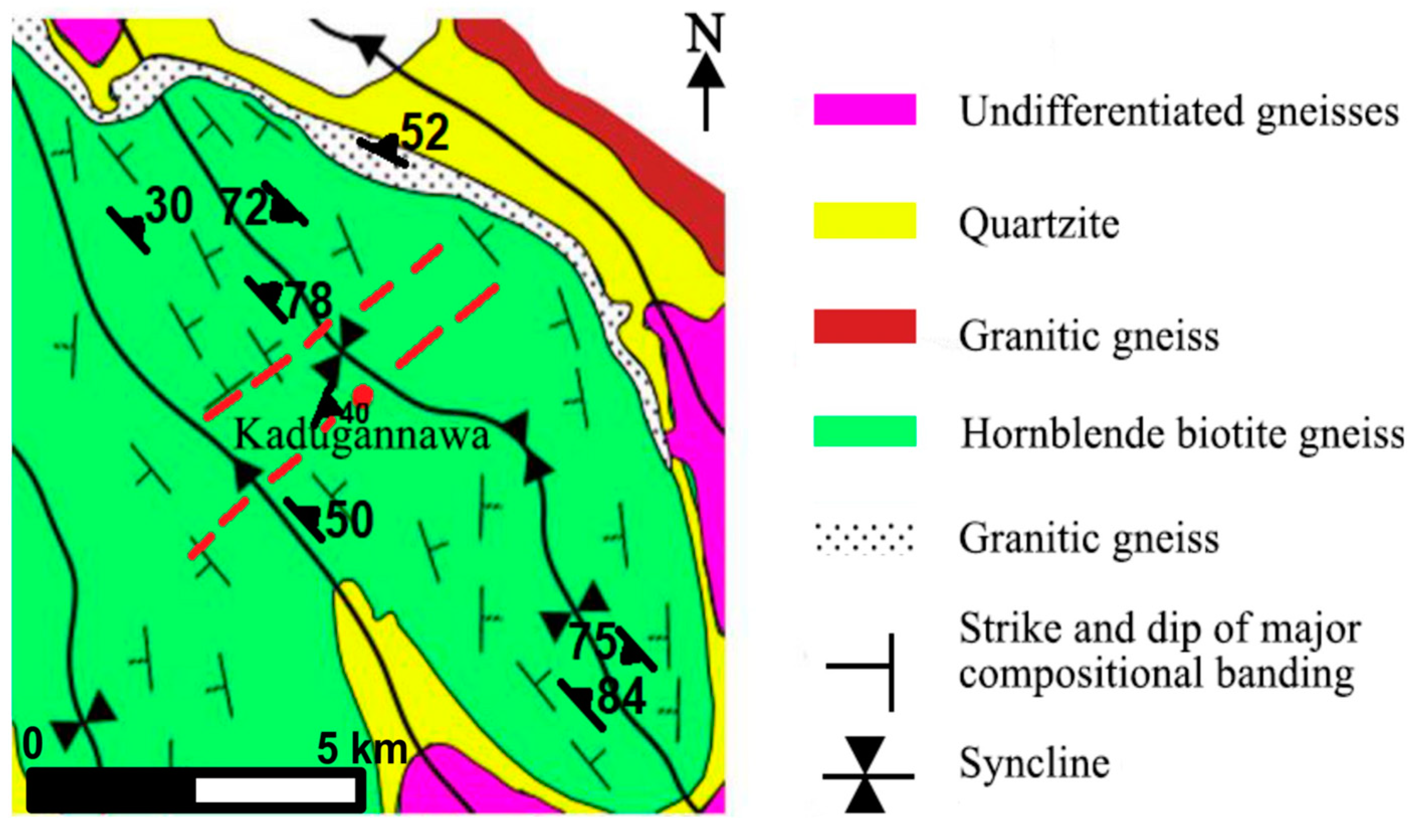
2.2. Geological Setting and Subsurface Conditions

Over 90% of Sri Lanka consists of highly crystalline amphibolite to granulite-grade metamorphic rocks of the Precambrian age. The remaining part is covered by sedimentary sequences in the northwestern portion that belong to the Jurassic, Miocene, and Holocene periods. Based on its lithology, isotope geochemistry, and tectonic–metamorphic history, the crystalline basement of Sri Lanka has been subdivided into four major units: Highland Complex (HC), Wanni Complex (WC), Vijayan Complex (VC), and Kadugannawa Complex (KC) [50,51].
The study area contains both HC and KC rocks. Common rocks in the area include biotite quartzofeldspathic gneiss, granitic gneiss, hornblende pyroxene biotite gneiss, charnockitic biotite gneiss, garnet biotite sillimanite gneiss, and crystalline limestone (Figure 2). Rocks in the contact zone are found to form transitional zones, with KC rocks lying on those of HC [52]. The rocks in the area generally trend in the N-W direction and they dip towards the N-E direction. Most of the land failures in the area occurred along the scarp slopes or inclined to the scarp slopes.
According to a seismic survey conducted oblique to slopes by the National Building Research Organization (NBRO) in Sri Lanka in 2022, a thick layer of colluvium soil exists beneath the topsoil layer (National Building Research Organization (NBRO), Sri Lanka; https://www.nbro.gov.lk/pahala-kadugannawa-land-instability, last accessed on 27 May 2024). The soil, found in many profiles of the study area, is characterized by poorly to very poorly sorted angular and sub-rounded gneissic rock fragments. These properties, along with the water seeping from elevated areas during rainy periods and gravitational forces, increase the risk of landslides. Furthermore, soil in such slopes is rich in clay associated with granular materials, low organic matter, and relatively slow hydraulic conductivity, making it susceptible to mass movements.

3. Methodology

The current study was carried out at two selected locations (Figure 1) with different geological, hydrological, and morphological settings (Figure 3, Figure 4 and Figure 5). A visual inspection and interpretation of aerial photographs or satellite imagery was conducted to locate past landslide features and major geological structures. The demarcation of landslides zones, measuring of slope angles and altitude, and determining of hydrogeological conditions were carried out during the mapping process. Slope angles at various locations within the study area were measured using clinometers and topographic maps. GPS or topographic maps were used to determine elevation variations across the landslide and surrounding terrain. Elevation changes can influence drainage patterns and contribute to instability. Factors such as surface water flow, the presence of springs, and drainage patterns were examined. Furthermore, the local and regional geological data such as strike, dip, foliation, weathering conditions and rock joints, and soil characteristics were recorded. The suspected failure region and its surroundings were investigated to define the boundaries of potential failures and identify instability features such as tension cracks, subsidence, and upheavals. In addition, cross-sections parallel to the slope were built for examination at potential failure areas.
Soil and weathered rock samples were collected for laboratory analysis (Figure 3 and Figure 5). Furthermore, major geological structures in the region were examined using the geologic interpretation of available aerial photographs and satellite imageries, as well as geological maps published by the Geological Survey & Mines Bureau, Sri Lanka, to obtain a better understanding of their role in landslide formation. The particle size distribution of several soil samples was determined by analyzing the weight percentage of particles retained on a series of standard sieves with decreasing sizes. The particle size distribution is plotted as a cumulative lognormal size distribution. The clay fraction of soil samples was subjected to X-ray powder diffraction analysis (using the Bruker D8 Advanced Eco Powder X-ray Diffractometer) to determine the presence of clay minerals. The analysis was carried out at the Postgraduate Institute of Science at the University of Peradeniya in Sri Lanka. Furthermore, secondary data on the study area were gathered from the published literature, whereas primary data were obtained through field investigations, stakeholders, and public consultation. The National Building Research Organization (NBRO) of Sri Lanka published data on the underground conditions of the slopes at both locations, which we also used for interpretation. The information is available at https://www.nbro.gov.lk/pahala-kadugannawa-land-instability, last accessed on 27 May 2024.
We integrate field observations and the data obtained in the field, as well as the data obtained in the laboratory. Furthermore, we assess the structural characteristics of the rock joints within this area, including their strike, dip direction, and dip angle. Moreover, the geological mapping and water flow paths were correlated with the aerial photographs, satellite imagery, and drone images.

4. Results and Discussion

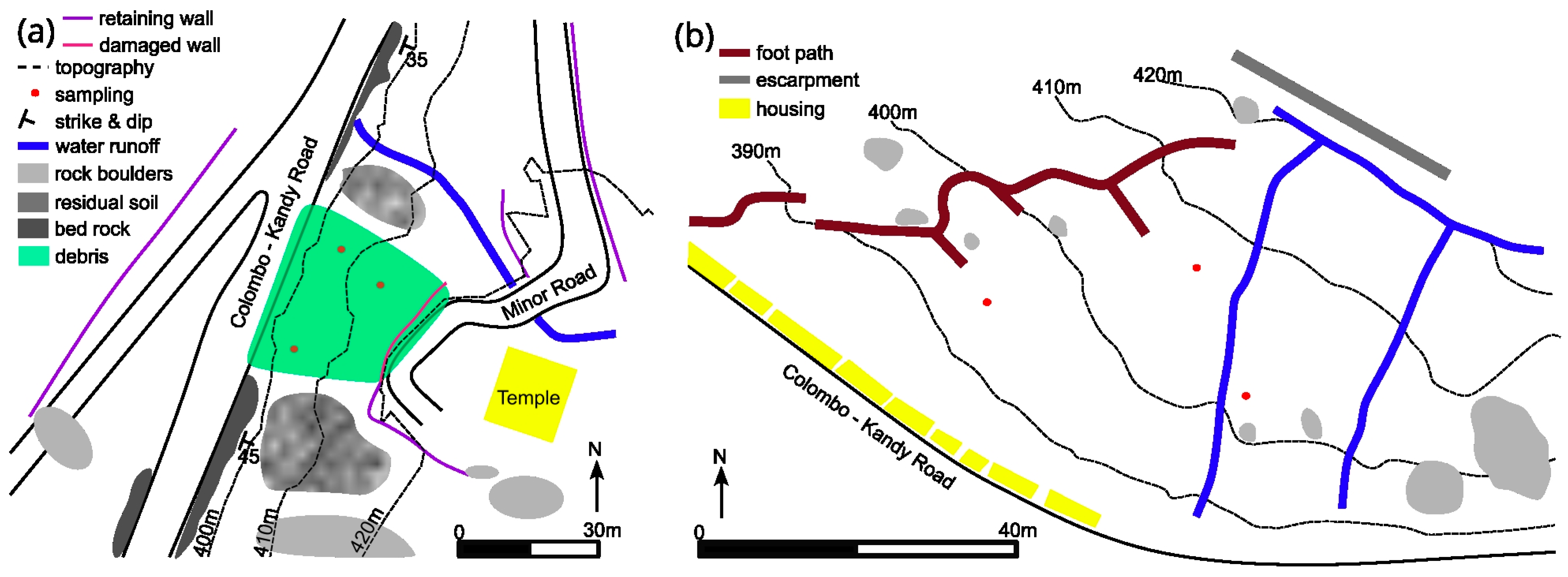
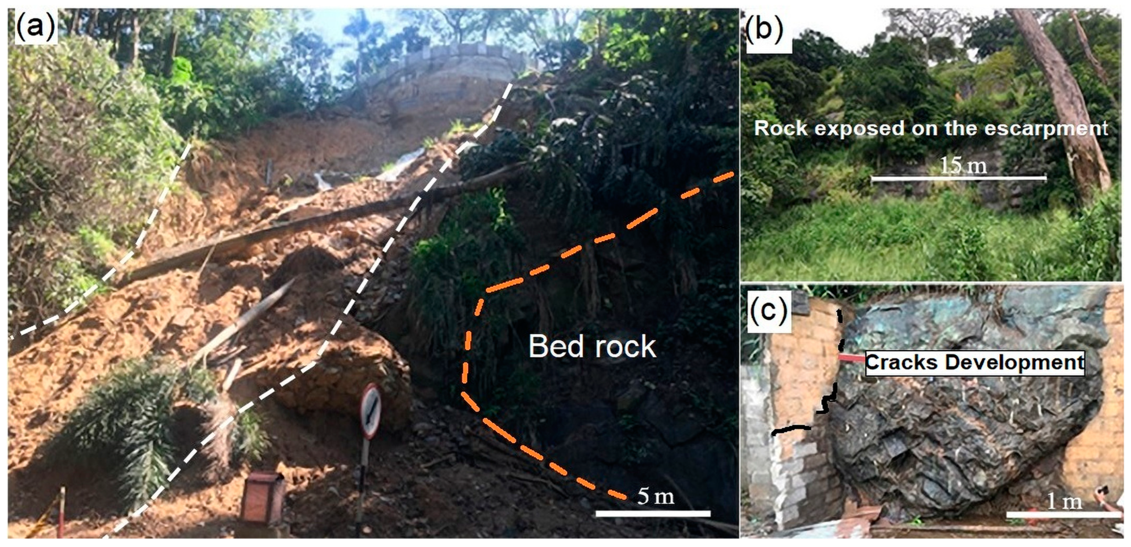
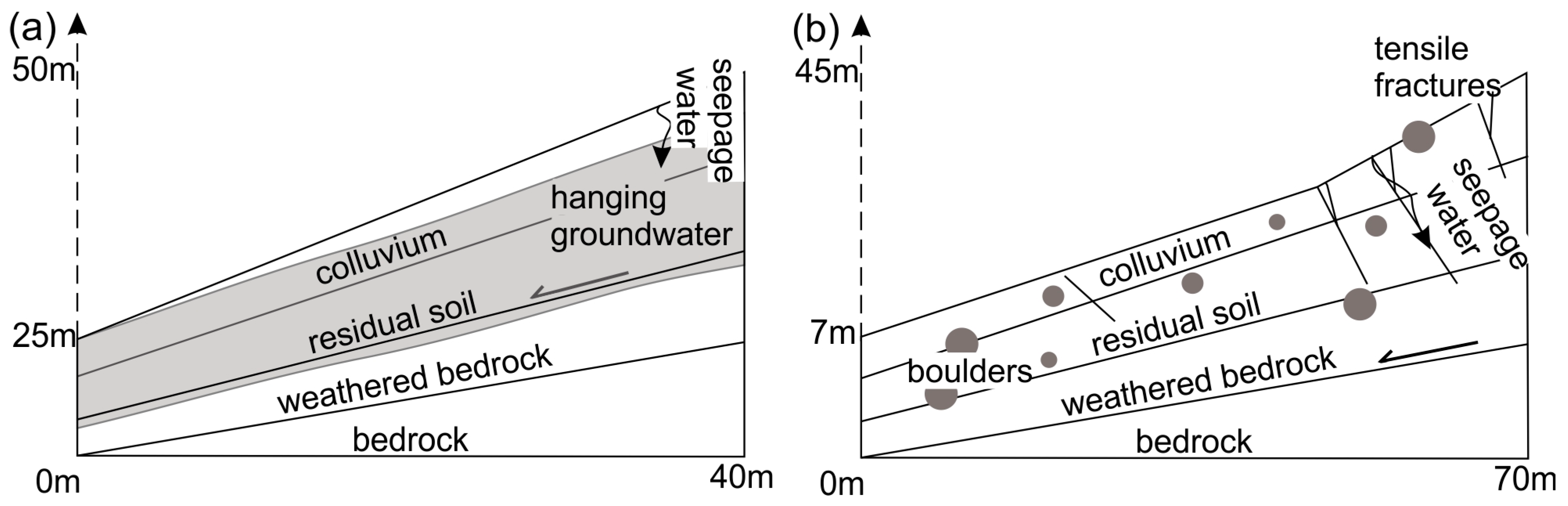
4.1. Distinguished Features of the Slope Failures at the Study Sites

The presence of residual soil formed on hornblende biotite gneiss distinguishes the slope failure area at site 1 from that at site 2. This gneiss has a dip angle of around 60° and slopes northeastward. In the crown area and closer to the right flank of the slope failure, small man-made ponds and natural perennial and semi-perennial drainage networks are prevalent. Large boulders, several square meters in size, occur obliquely to the strike of the bedrock and are ubiquitous in the southern and top areas of the slope (Figure 3a). Because they are oriented in different directions, this indicates that the slope has been formed by one or more large-scale landslides that occurred a long time ago. Furthermore, residual soil and bedrock exposures are present on the southern side of the failure area (Figure 3a). The failure area has an irregular shape, with a length of 35–45 m and a width of 35–40 m, and extends from an elevation of 420 m down to 395 m. The mass movement occurred on the oblique to the dipping angle of the basement rock, and the residual soil moved as a single mass until it reached the weathered bedrock. The thickness of soil in the crown area of the slide is higher, up to 15 m, and a steep main scarp has developed (Figure 4a). This can be identified as a translational landslide.
Because bedrock fragments are not present in the soil mass, it was revealed that the topography, rather than bedrock joints, is primarily responsible for slope failure. Furthermore, the mass movement does not follow the joint patterns of the basement rocks, which are approximately N60°E and N45°W. The exposed slide surface of the basement rock weakened due to weathering along the mica- and feldspar-rich layers that are common in weathered rocks. This chemical weathering is known to weaken the hornblende biotite gneiss’s surface [54]. The presence of non-engineered man-made structures, as well as the diversion of natural streams or water flow paths during building construction, indicate an anthropogenic influence on the natural conditions of the slope.
Site 2 spans a polygon-shaped area of up to 120 m wide at the foot and 40 m wide at the top that is roughly 60 m long. It is characterized by very steep (35°–55°) to extremely steep (up to 70°) slopes with numerous bedrock exposures (Figure 4b). Two large rock scarps are present in the area that have not been subjected to slope failure and formed due to regional geological conditions because the slope is located on a limb of a synform. The top of the slide is situated above the road, while the toe lies at the cut bank of the road. The crown of the landslide is on the upper parts of the hills, close to the rock exposures of the escarpment. The upper part of the area is covered in soil with sparse vegetation. The hummocky to relatively smooth top surfaces, the presence of narrow steep slopes and boulders of varying sizes (Figure 3b), and the diversity of the vegetation, ranging from small bushes to large trees, all indicate that the slope had been subjected to mass movement at various stages over the past hundred years. The basement rock mainly consists of charnockitic gneiss with small bands of hornblende biotite gneiss. The mountain escarpment is made up of rocks with a high joint and fracture density, as well as a thin layer of soil and colluvium. The construction of paths and small buildings, primarily along the toe area of the failures, has an anthropogenic influence on the slope (Figure 3b). Similar to site 1, natural streams on the surface are common, and there are also seepages and springs on the slope. The land failures predominantly occurred along the planes of joints and faults. Both rockfalls and small-scale rotational slides occurred along the slope. Unplanned construction along the roadside and the diversion of water in the upper region of the slope resulted in significant rainwater infiltration. The heavy and prolonged rainfall, as described in Section 2, coupled with the accumulation of groundwater throughout the month on the slopes of the escarpments, generated strong destabilizing forces on the loose materials. The excess pore-water pressure within the soil reduced the shear strength, causing boulders (with a size ranging from 5 m to less than 1 m) to be transported within the moving debris.
Surficial features at site 2 can be classified into three zones: (i) the crown area, which contains less disturbed soil masses, rock boulders, and basement rock exposures; (ii) the main body, which includes several minor scarps and cracks, as well as highly disturbed colluvial soil with boulders; and (iii) the toe area, which contains disturbed geologic materials and small-scale mud flows. The crown of the slide is closer to the scarp slope of the basement rocks, while the toe is on the road. Field observations within the study period noted that, during the rainy season, the development of cracks between the rock masses and soil is common due to the seeping of water through the fractures in the basement rocks or the boundary between the rock masses and soil, indicating the instability of the slope. Human activity in the middle of the slope and toe areas is quite high, involving the diversion of natural water flow paths and the cutting of slopes for construction. The slope of the adjacent area is partly eroded due to its height and consists of rock boulders ranging from 0.5 to 7 m. On colluvial and residual soils, weathered rock boulders are common at relatively shallow depths. The formation of colluvium deposits may be attributed to climatic fluctuations and rock falls [55,56]. Additionally, duricrusts ranging from a few millimeters to several centimeters may form due to the frequent seepage of groundwater [57]. Intensively weathered colluvial soil has been mixed up with residual weathering profiles. Houses and small boutiques have been constructed on colluvial soil formations (Figure 4c).

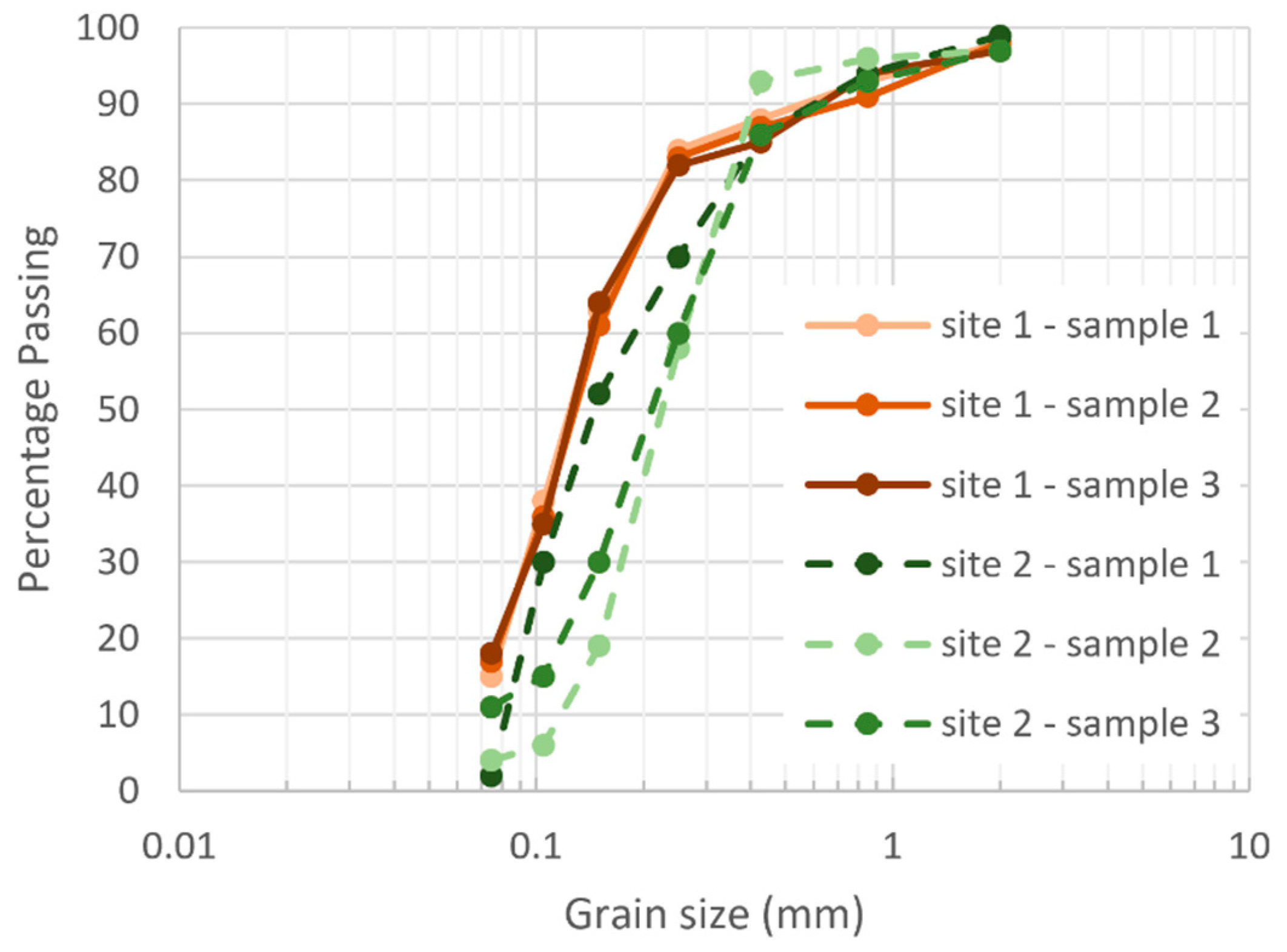
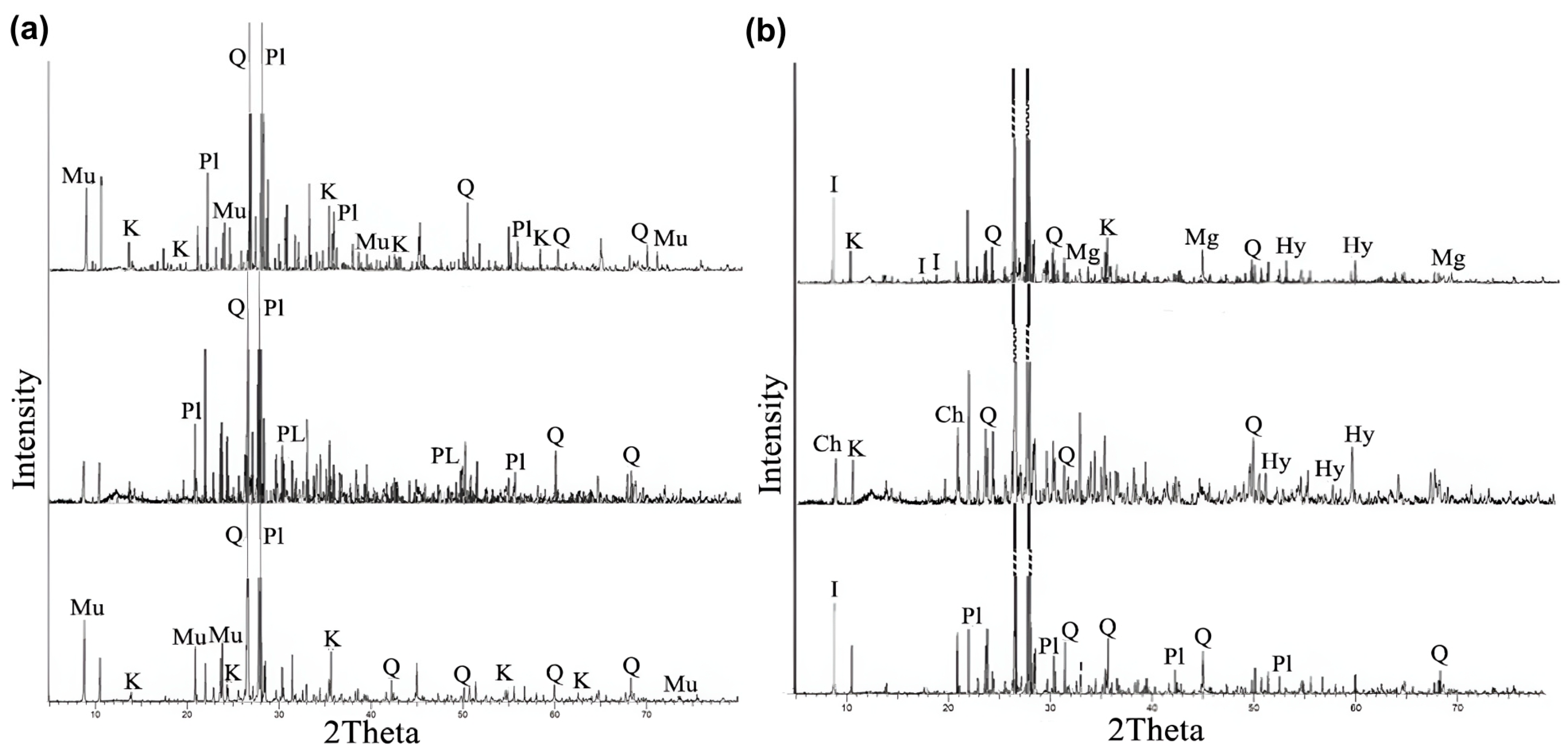
4.2. Soil Texture and Clay Mineralogy

The sampling locations of soil for laboratory analyses are shown in Figure 3 and the results of the sieve analysis for two sites are presented in Figure 5. The sieve analysis of the soil revealed that the clay fraction of the soils at site 1 is generally higher than 10% and has a fine texture. Therefore, the shrink–swell properties of the soil are high, indicating that the soils exhibit extreme expansion potential, making them susceptible to landslides [58]. The grain size distribution of overburdened soils shows that they have a similar texture, implying that they derived from similar types of chemical weathering. The variable textures of the soils at site 2 indicate that they may have been formed after undergoing several physicochemical processes. Further, the presence of colluvium in the soil has also contributed to the formation of the soil, as well as the basement rock. This is because colluvium has a higher infiltration capacity compared to the residual soil found at site 1. Therefore, overland flow is reduced and infiltration increases, resulting in the formation of clay-rich soils. Further, the content of cobbles and pebbles is considerably higher in some areas of the soil in the site.
The prominent clay mineralogical composition of the soil in the studied sites is illustrated in Figure 6. The fine fraction of the weathering profile of soils at site 1 contains kaolinite and muscovite, in addition to quartz. Experimental results revealed that the octahedral surface of kaolinite is hydrophilic. Montmorillonite, illite, and mica show a range of wettability: montmorillonite wets strongly, illite wets strongly to weakly, and mica wets completely [59]. This implies that kaolinite and muscovite mica at site 1 have a high water-bearing capacity due to their negative charges. Due to their plate-like morphology, clay minerals associated with water can increase the lubrication property of soils, which may induce slope instability [60,61]. Muscovite mica acts as a such a lubricant since it has perfect cleavage, high flexibility, and high elasticity [62]. Although kaolinite has low cation exchange capacity and limited swelling and shrinking properties, hydrophilic kaolinite has high lubrication properties due to its plate morphology [61]. Slipping zones that exhibit a lubricating effect between landslide masses and bedrock may function as impervious boundaries, effectively segregating landslide masses from the surrounding environment [63]. This agrees with our field observation, reported above, that the exposed slide surface was covered by mica- and feldspar-rich layers. Therefore, both muscovite and kaolinite in the fine-fraction-rich soil at site 1 resulted in slope failure. Triaxial and direct shear tests from the shear zone of the Watawala Earthslide (Sri Lanka) revealed a significant loss of strength in the involved clay-rich soils due to this lubrication effect [64]. Also, in the slope failure in Kahagolla, the role of weak, clay-rich soil layers has been highlighted [65].
In contrast, site 2 is low in such clays, with them forming less than 5% of the gravitational fraction in the sieving analysis. Therefore, the contribution of clay to the mass movement in the area is low.

4.3. Subsurface Saturation and Pore Water Pressure

The slope failure that occurred in the hillslope of site 1 was influenced by several factors, such as micaceous soil, water storage in the soil due to water seepage through water paths, large trees, fractures that developed in the basement rocks, and slope cutting for the construction of roads. Due to the limited presence of fractured rocks and the predominance of clay-rich residual soil at site 1, the increased matrix infiltration led to an advancement in pore water pressure within the soil. This, in turn, reduced the effective stress, culminating in the failure of the slope. Additionally, the increased saturation of the matrix material contributed to a reduction in the shear strength of the soil.
At site 2, the overburdened colluvium soil, containing boulders of varying sizes, facilitated the infiltration of water received from both rain and streams running perpendicular to and along the slope. Field observations and drone images revealed that the prominent joints in the hard rocks at the site are vertical, with orientations of N45°W. The openings of these joints, extending up to 2.5 m, contribute to the higher permeability, especially at the top of the hill. Further, clay-filled areas in joints also serve as water flow pathways where significant joints occur due to past mass displacement spanning centuries. The water pressure in these areas is generated by streams located above and to the west of the concentrated fracture zone. This water then moves horizontally into the jointed areas, which are mostly made up of highly fractured and decomposed hard rock, causing increased water pressure, decreased shear strength, and soil displacement. Fractured rocks provide pathways for water to bypass the fine- to medium-grained matrix and flow more rapidly. Since the location is close to the hinge of the synform (Figure 2) the fracture intensity is high and variable even within short distances. On the other hand, possible flow paths may occur along the shear zone in the scarp of the major rock slope failure at the site.
Therefore, the intense fractures of bedrock and local and regional hydraulic influences (water penetrating through fractures and boulder–soil contacts) led to slope instability at site 2. Further, the complex soil conditions at the site triggered slope instability during periods of heavy rainfall. Additionally, surface water movements, alterations in water flow paths caused by bedrock topography and ecological factors, along with human-induced changes, have also contributed to the promotion of mass movement.

4.4. Influence of Regional Geological and Hydrogeological Conditions

Regional geological settings in hard rock terrains can have a significant impact on landslides [66,67]. Large-scale geological structures and extended fractures may lead to the development of geologically weak areas. For example, the hinge of folds consists of high-intensity fractures and joints, leading to the development of weak areas. The study areas and the surrounding region are characterized by large-scale double-plugging synforms (Figure 2) and antiforms, which resulted in the major morphological features of the area [49]. Most of the valleys in the area developed in the core areas of synforms, and escarpment slopes are found in their limbs. The presence of high-intensity fractures in the area and reginal fracture network (lineaments) indicates that the basement geological setting of slopes is weak in terms of its geological structure. Based on the seismic survey conducted by the NBRO (referenced above) the thickness of the weak formations varies between 5 and 8 m at this specific site. Therefore, such slopes can easily become susceptible to landslides.
Faults and shear zones tend to confine or promote the movement of groundwater, which can impact the stability of slopes [68]. In areas with hard rock aquifers, groundwater can travel through the lineaments, joints, and faults that act as pathways for water flow. Elevated areas situated near the Kadugannawa area with a basin morphology can accumulate more groundwater in hard rock fractured zones, and such groundwater bodies release water at the escarpments in the Kadugannawa area. Even during dry periods, the presence of springs on the upper slopes of the area indicates that the spring water should be sourced from other areas, such as where a large valley is located in the northern elevated part of the area. Groundwater in the valley of the hilltop in the study area may be released through the fractures and flow down into slopes closer to the road. Therefore, pore water pressure and natural springs along the slope can be developed. Under these circumstances, it can be assumed that the areas of site 2 are prone to land instability, not only due to local geological settings but also because of regional geological conditions. However, site 1 has not been influenced much by basement structures but is mainly affected by recent subsurface processes. The determination of hill slope stability depends largely on rock strength, as this controls the impact of groundwater and the hydrostatic pore pressure entering the subsurface. The weakest unit within the rock mass is the controlling factor for threshold angles. Rocks with deep fissures may become weaker while becoming more permeable. When the strength of the surface material is less than or equal to that of the underlying material, the maximum stable gradient is determined by the weaker surface material. Therefore, it was proposed that the density of surface fractures governs the threshold angles of stability, whereas the depth of bedrock fracturing limits the magnitude of landslides [69].

4.5. Summary on Failure Modes and Mechanisms

Due to their differences in lithology, soil texture, and hydrogeological conditions, both sites show different failure modes and mechanisms. The studied event at site 1 is a translational debris flow. The failure plane developed along the clay-rich layer of weathered bedrock below the residual soil due to the lubrication effect of the mica and kaolinite minerals, which caused a significant drop in cohesive and shear resistance due to the percolating water during the prolonged rainfall in November 2021. The increasing pore water pressure due to the limited infiltration capacity of the weathered bedrock further reduced the normal stress and subsequently caused slope failure (Figure 7a).
Tensile crack opening around the crown and upper part of the slope at site 2 indicates that tensile failure initiated a landslide, which then transitioned into rotational debris flow with minor rockfall. The high fracture density due to the regional geology of an anticline allows water to quickly infiltrate deeper layers while also providing cohesionless planes (Figure 7b). The presence of boulders of varying sizes within the residual soil further reduces the cohesiveness of the soil along the soil–boulder interfaces, which also provide preferential fluid pathways.
While both events occurred in close spatial proximity and temporal succession during the monsoon period in November 2021, based on our analysis, we hypothesize that the prolonged rainfall was a triggering cause for the landslide at site 1 but the singular heavy rain event between the 8th and 10th of November was causative of the slope failure at site 2. From the grain size distribution and the absence of fractured or other preferential pathways, one can reasonably assume that site 1 has a lower infiltration capacity than site 2. Hence, prolonged rainfall caused deep infiltration into the soil, lubricating the clay and continuously building up pore pressure in the soil at site 1. As site 2 has higher infiltration rates due to the significantly smaller fine fraction and the presence and opening of tensile cracks, seepage water can reach a greater depth more quickly. The high-intensity rainfall from the 8th to 10th of November caused impounded water inside the fractures, increasing pore pressure along the existing and propagating fractures and causing slope failure.
Anthropogenic surface alterations such as surface water paths, agriculture, and buildings might contribute to the failure caused by increased water input during days of reduced precipitation, the loss of root water uptake and stabilizing deep-reaching roots, and the increased load along the slope. Additional local groundwater flow into the slopes might also facilitate rock failure.

4.6. Proposed Mitigation Measures

To ensure safety, it is recommended to employ two distinct construction techniques that consider the present geological and hydrological conditions of the two studied sites. This suggestion aligns with the findings of Pradhan and Siddique in 2020 [70] and considers the potential impact of future climate change worldwide.
The most likely slip surface at site 1 is residual clayey soil and weathered rock associated with hydrophilic secondary minerals. The presence of water in the soil decreases the residual soil profile’s shear strength. Therefore, managing surface water infiltration into the soil is crucial. This is in accordance with the methods proposed by Bracko et al. (2022) [14] to reduce the water net infiltration in soils of low permeability. Further, it is necessary to utilize ground improvement methods to increase the strength and stability of weak soil [71,72]. This can involve several methods, such as chemical methods, stabilization through geotextile and fabrics, and mechanical stabilization to improve the soil’s engineering properties. Reinforced soil structures or soil nailing are the most appropriate constructions for the site [73,74]. Our study results show that, at site 1, the clay-rich soil layers including the minerals muscovite and kaolinite act as potential failure planes due to their lubricating effect. Mitigation measures either need to improve water drainage at these layers through drainage systems or stabilize these layers mechanically, potentially also through respective land use and cultivation with deep-reaching roots. Clay-rich layers can be identified using geoelectrical methods during field investigations [44].
The high load of unstable soil in site 2 in the upper slopes, the flow of water into the surface of the slopes, groundwater influence in the upper slope and the perched water table, and the underlying colluvium material, which causes soil softening, are the main reasons for instability in the site. As long-term measures, introducing a new surface drainage system to divert the rainfall water, strengthening the affected area by adding soil nails, constructing a new retaining wall next to the main road to support the load [75,76,77], and the implementation of regulations for the construction and diversion of any water paths are required. In addition, to improve the stability of the risk area marked at site 2, it is necessary to lower the groundwater level using long drains (pipes) connected to fractured basement rock to remove water. Gravity-type retaining walls must be built at the toes of sites to prevent the lateral movement of soil masses and soil erosion.

5. Conclusions

Our study shows that within less than 600 m distance, two very different failure events triggered by the same precipitation event occurred in 2021 in the Kadugannawa area along the Colombo–Kandy Road. The slope failure at site 1 is attributed to micaceous- and feldspar-rich residual soil, an altered natural water flow resulting in surface water seepage, and the presence of large trees. Site 2, on the other hand, was unstable due to colluvium-rich overburdened soil, intense bedrock fractures, and hydraulic influences from local and regional water sources infiltrating through fractures and boulder–soil contacts. Hence, the resulting counter measures differ between the two sites, as discussed above. At site 1, the focus should be on managing surface water infiltration into the soil, coupled with ground improvement methods to enhance the strength and stability of the weak soil, such as soil nailing. For site 2, long-term measures involve implementing a new surface drainage system, as well as the installation of long drain connected to the fractured basement rock to lower the groundwater level. Reinforcing the area with soil nails or retaining walls could provide additional stability, and enforced rules regarding construction and water diversion are especially required.
As such, our work provides explicit evidence of the necessity of high-resolution hazard zone mapping in Sri Lanka and in similar highly heterogeneous geological and geomorphological areas, especially along highways and other crucial infrastructure. Commonly applied satellite-based remote sensing methods might be insufficient due to their coarse grid of available observations and their inability to account for geological differences. With the anticipated change in precipitation patterns due to climate change, a re-evaluation of failure-prone hillslopes might be necessary. Our results also indicate that specific mitigation measures need to be applied to individual sites following a thorough investigation of the causative factors at each landslide-prone location.

Author Contributions

Conceptualization, S.M.P., H.W. and T.H.; methodology, S.M.P. and H.W.; investigation, S.M.P. and H.W.; data curation, S.M.P. and H.W.; writing—original draft preparation, S.M.P., H.W. and T.H.; writing—review and editing, S.M.P., H.W. and T.H.; visualization, S.M.P., H.W. and T.H.; supervision, T.H. All authors have read and agreed to the published version of the manuscript.

Funding

This research received no external funding.

Data Availability Statement

The original contributions presented in the study are included in the article, further inquiries can be directed to the corresponding author/s.

Acknowledgments

We would like to express our gratitude to K.N. Bandara and other officers of NBRO for their valuable comments during the study and for granting us the necessary facilities to carry out the research. Additionally, the authors extend their heartfelt thanks to the Department of Geology, University of Peradeniya, for providing the laboratory facilities for the analysis.

Conflicts of Interest

The authors declare no conflicts of interest.

References

  1. Bukhari, M.H.; da Silva, P.F.; Pilz, J.; Istanbulluoglu, E.; Görüm, T.; Lee, J.; Karamehic-Muratovic, A.; Urmi, T.; Soltani, A.; Wilopo, W.; et al. Community perceptions of landslide risk and susceptibility: A multi-country study. Landslides 2023, 20, 1321–1334. [Google Scholar] [CrossRef]
  2. Haque, U.; Blum, P.; Da Silva, P.F.; Andersen, P.; Pilz, J.; Chalov, S.R.; Malet, J.P.; Auflič, M.J.; Andres, N.; Poyiadji, E.; et al. Fatal landslides in Europe. Landslides 2016, 13, 1545–1554. [Google Scholar] [CrossRef]
  3. McColl, S.T. Landslide causes and triggers. In Landslide Hazards, Risks, and Disasters, 2nd ed.; Davies, T., Rosser, N., Shroder, J.F., Eds.; Elsevier: Amsterdam, The Netherlands, 2021; pp. 13–14. [Google Scholar]
  4. Margottini, C.; Canuti, P.; Sassa, K. Landslide Science and Practice, 1st ed.; Springer: Berlin, Germany, 2013. [Google Scholar]
  5. Alupoae, D. Landslides—A result of urban expansion in the metropolitan area of Iasi City. Bull. Polytech. Inst. Jassy Constr. Archit. Sect. 2013, 59, 69–78. [Google Scholar]
  6. Kazmi, D.; Qasim, S.; Harahap, I.S.H.; Baharom, S.; Imran, M.; Moin, S. A study on the contributing factors of major landslides in Malaysia. Civ. Eng. J. 2016, 2, 669–678. [Google Scholar] [CrossRef]
  7. Tanyas, H.; Görüm, T.; Kirschbaum, D.; Lombardo, L. Could road constructions be more disastrous than an earthquake in terms of landsliding? Nat. Hazards 2022, 112, 639–663. [Google Scholar] [CrossRef]
  8. Igwe, O.; Ayogu, C.N.; Maduka, R.I.; Ayogu, N.O.; Ugwoke, T.A. Slope failures and safety index assessment of waste rock dumps in Nigeria’s major mines. Nat. Hazards 2023, 115, 1331–1370. [Google Scholar] [CrossRef]
  9. Mahanta, B.; Singh, H.O.; Singh, P.K.; Kainthola, A.; Singh, T.N. Stability analysis of potential failure zones along NH-305, India. Nat. Hazards 2016, 83, 1341–1357. [Google Scholar] [CrossRef]
  10. Bonnard, C.; Noverraz, F. Influence of climate change on large landslides: Assessment of long-term movements and trends. In Proceedings of the International Conference on landslides-Causes, Impacts and Countermeasures, Davos, Switzerland, 17–21 June 2001. [Google Scholar]
  11. Gariano, S.L.; Guzzetti, F. Landslides in a changing climate. Earth-Sci. Rev. 2016, 162, 227–252. [Google Scholar] [CrossRef]
  12. Jakob, M. Landslides in a changing climate. In Landslide Hazards, Risks, and Disasters, 2nd ed.; Davies, T., Rosser, N., Shroder, J.F., Eds.; Elsevier: Amsterdam, The Netherlands, 2021; pp. 505–579. [Google Scholar]
  13. Neranjan, S.; Uchida, T.; Yamakawa, Y.; Hiraoka, M.; Kawakami, A. Geometrical Variation Analysis of Landslides in Different Geological Settings Using Satellite Images: Case Studies in Japan and Sri Lanka. Remote Sens. 2024, 16, 1757. [Google Scholar] [CrossRef]
  14. Bracko, T.; Zlender, B.; Jelusic, P. Implementation of Climate Change Effects on Slope Stability Analysis. Appl. Sci. 2022, 12, 8171. [Google Scholar] [CrossRef]
  15. Bozzolan, E.; Holcombe, E.A.; Pianosi, F.; Marchesini, I.; Alvioli, M.; Wagener, T. A mechanistic approach to include climate change and unplanned urban sprawl in landslide susceptibility maps. Sci. Total Environ. 2023, 858, 159412. [Google Scholar] [CrossRef]
  16. Subasinghe, C.N.; Kawasaki, A. Assessment of physical vulnerability of buildings and socio-economic vulnerability of residents to rainfall induced cut slope failures: A case study in central highlands, Sri Lanka. Int. J. Disaster Risk Reduct. 2021, 65, 102550. [Google Scholar] [CrossRef]
  17. Rathnaweera, T.D.; Palihawadana, M.P.; Rangana, H.L.L.; Nawagamuwa, U.P. Effects of climate change on landslide frequencies in landslide prone districts in Sri Lanka. In Civil Engineering Research Exchange Symposium; University of Ruhuna: Ruhuna, Sri Lanka, 2012. [Google Scholar]
  18. Ratnayake, U.; Herath, S. Changing rainfall and its impact on landslides in Sri Lanka. J. Mt. Sci. 2005, 2, 218–224. [Google Scholar] [CrossRef]
  19. Senanayake, S.; Pradhan, B. Predicting soil erosion susceptibility associated with climate change scenarios in the Central Highlands of Sri Lanka. J. Environ. Manag. 2022, 308, 114589. [Google Scholar] [CrossRef]
  20. Chandrajith, R. Geology and geomorphology. In The Soils of Sri Lanka, 1st ed.; Mapa, R.B., Ed.; Springer: Berlin, Germany, 2020; pp. 23–34. [Google Scholar] [CrossRef]
  21. Cooray, P.G. The Geology of Sri Lanka, 2nd ed.; National Museum of Sri Lanka: Colombo, Sri Lanka, 1984.
  22. Vanacker, V.; von Blanckenburg, F.; Hewawasam, T.; Kubik, P.W. Constraining landscape development of the Sri Lankan escarpment with cosmogenic nuclides in river sediment. Earth Planet. Sci. Lett. 2007, 253, 402–414. [Google Scholar] [CrossRef]
  23. Von Blanckenburg, F.; Hewawasam, T.; Kubik, P.W. Cosmogenic nuclide evidence for low weathering and denudation in the wet, tropical highlands of Sri Lanka. J. Geophys. Res. Earth Surf. 2004, 109, F03008. [Google Scholar] [CrossRef]
  24. Crawford, M.M.; Bryson, L.S. Assessment of active landslides using field electrical measurements. Eng. Geol. 2018, 233, 146–159. [Google Scholar] [CrossRef]
  25. Meng, Z.J.; Ma, P.H.; Peng, J.B. Characteristics of loess landslides triggered by different factors in the Chinese Loess Plateau. J. Mt. Sci. 2021, 18, 3218–3229. [Google Scholar] [CrossRef]
  26. Gunathilake, K.L.W.I.; Jayathilake, P.P.G.; Fernando, N.; Jayasinghe, N.; Amaratunga, D.; Haigh, R. Living with Landslide Risks: A Case of Resistance to Relocation Among Vulnerable Households Residing in the Kegalle District of Sri Lanka. In Rebuilding Communities after Displacement; Hamza, M., Amaratunga, D., Haigh, R., Malalgoda, C., Jayakody, C., Senanayake, A., Eds.; Springer: Cham, Switzerland, 2023. [Google Scholar] [CrossRef]
  27. Duan, X.; Hou, T.S.; Jiang, X.D. Study on stability of exit slope of Chenjiapo tunnel under extreme rainstorm conditions. Nat. Hazards 2021, 107, 1387–1411. [Google Scholar] [CrossRef]
  28. Pradhan, S. Impacts of Road Construction on Landsliding in Nepal. Ph.D. Dissertation, Durham University, Durham, UK, 2021. [Google Scholar]
  29. Ryabukhin, A.K.; Leyer, D.V.; Lubarskiy, N.N. Peculiarities of designing landslide constructions on the example of engineering protection of buildings and roads in the city of Sochi (Russia). In Proceedings of the International Multidisciplinary Scientific GeoConference: SGEM, Albena, Bulgaria, 16–25 August 2020. [Google Scholar]
  30. Perera, E.N.C.; Jayawardana, D.T.; Jayasinghe, P.; Bandara, R.M.S.; Alahakoon, N. Direct impacts of landslides on socio-economic systems: A case study from Aranayake, Sri Lanka. Geoenviron. Disasters 2018, 5, 11. [Google Scholar] [CrossRef]
  31. Bandara, R.M.S.; Jayasingha, P. Landslide disaster risk reduction strategies and present achievements in Sri Lanka. Geosci. Res. 2018, 3, 21–27. [Google Scholar] [CrossRef]
  32. Kaya, A.; Alemdağ, S.; Dağ, S.; Gürocak, Z. Stability assessment of high-steep cut slope debris on a landslide (Gumushane, NE Turkey). Bull. Eng. Geol. Environ. 2016, 75, 89–99. [Google Scholar] [CrossRef]
  33. Wei, Z.; Yin, G.; Wang, J.G.; Wan, L.; Jin, L. Stability analysis and supporting system design of a high-steep cut soil slope on an ancient landslide during highway construction of Tehran–Chalus. Environ. Earth Sci. 2012, 67, 1651–1662. [Google Scholar] [CrossRef]
  34. Popescu, M.E.; Sasahara, K. Engineering measures for landslide disaster mitigation. In Landslides–Disaster Risk Reduction, 1st ed.; Sassa, K., Canuti, P., Eds.; Springer: Berlin, Germany, 2009; pp. 609–631. [Google Scholar] [CrossRef]
  35. Paswan, A.P.; Shrivastava, A.K. Modelling of rainfall-induced landslide: A threshold-based approach. Arab. J. Geosci. 2022, 15, 795. [Google Scholar] [CrossRef]
  36. Kazmi, D.; Qasim, S.; Harahap, I.S.H.; Baharom, S.; Mehmood, M.; Siddiqui, F.I.; Imran, M. Slope remediation techniques and overview of landslide risk management. Civ. Eng. J. 2017, 3, 180–189. [Google Scholar] [CrossRef]
  37. Da Silva, R.P.; Lacerda, W.A.; Coelho Netto, A.L. Relevant geological-geotechnical parameters to evaluate the terrain susceptibility for shallow landslides: Nova Friburgo, Rio de Janeiro, Brazil. Bull. Eng. Geol. Environ. 2022, 81, 57. [Google Scholar] [CrossRef]
  38. Dai, F.C.; Lee, C.F.; Ngai, Y.Y. Landslide risk assessment and management: An overview. Eng. Geol. 2002, 64, 65–87. [Google Scholar] [CrossRef]
  39. Bandara, R.M.S.; Weerasinghe, K.M. Overview of Landslide Risk Reduction Studies in Sri Lanka. In Landslide Science and Practice; Margottini, C., Canuti, P., Sassa, K., Eds.; Springer: Berlin, Germany, 2013. [Google Scholar] [CrossRef]
  40. Maes, J.; Kervyn, M.; de Hontheim, A.; Dewitte, O.; Jacobs, L.; Mertens, K.; Vanmaercke, M.; Vranken, L.; Poesen, J. Landslide risk reduction measures: A review of practices and challenges for the tropics. Prog. Phys. Geogr. Earth Environ. 2017, 41, 191–221. [Google Scholar] [CrossRef]
  41. Del Grecco, O.; Oggeri, C. Reinforcement design and control of rock slopes above tunnel portals in northern Italy. Int. J. Rock Mech. Min. Sci. 2004, 41, 786–791. [Google Scholar] [CrossRef]
  42. Xie, J.; Uchimura, T.; Wang, G.; Selvarajah, H.; Maqsood, Z.; Shen, Q.; Mei, G.; Qiao, S. Predicting the sliding behavior of rotational landslides based on the tilting measurement of the slope surface. Eng. Geol. 2020, 269, 105554. [Google Scholar] [CrossRef]
  43. Fang, K.; Miao, M.; Tang, H.; Jia, S.; Dong, A.; An, P.; Zhang, B. Insights into the deformation and failure characteristic of a slope due to excavation through multi-field monitoring: A model test. Acta Geotech. 2023, 18, 1001–1024. [Google Scholar] [CrossRef]
  44. Moradi, S.; Heinze, T.; Budler, J.; Gunatilake, T.; Kemna, A.; Huisman, J.A. Combining Site Characterization, Monitoring and Hydromechanical Modeling for Assessing Slope Stability. Land 2021, 10, 423. [Google Scholar] [CrossRef]
  45. Alcántara-Ayala, I.; Garnica-Peña, R.J. Landslide Warning Systems in Low-And Lower-Middle-Income Countries: Future Challenges and Societal Impact. In Progress in Landslide Research and Technology; Sassa, K., Konagai, K., Tiwari, B., Arbanas, Ž., Sassa, S., Eds.; Springer: Cham, Switzerland, 2022; Volume 1. [Google Scholar] [CrossRef]
  46. Fang, K.; Dong, A.; Tang, H.; An, P.; Wang, Q.; Jia, S.; Zhang, B. Development of an easy-assembly and low-cost multi-smartphone photogrammetric monitoring system for rock slope hazards. Int. J. Rock Mech. Min. Sci. 2024, 174, 105655. [Google Scholar] [CrossRef]
  47. Konagai, K.; Karunawardena, A.; Bandara, K.N.; Sassa, K.; Onishi, R.; Uzuoka, R.; Asano, S.; Sasahara, K.; Jayakody, S.; Ariyarathna, I. Early Warning System against Rainfall-Induced Landslide in Sri Lanka. In Progress in Landslide Research and Technology; Sassa, K., Konagai, K., Tiwari, B., Arbanas, Ž., Sassa, S., Eds.; Springer: Cham, Switzerland, 2022; Volume 1. [Google Scholar] [CrossRef]
  48. Punyawardena, B.W.R. Climate. In The Soils of Sri Lanka, 1st ed.; Mapa, R.B., Ed.; Springer: Berlin, Germany, 2020; pp. 13–22. [Google Scholar] [CrossRef]
  49. Vitanage, P. Post-Precambrian uplifts and regional neotectonic movements in Ceylon. In Proceedings of the 24th IGC, Montreal, QC, Canada, 21–31 August 1972. [Google Scholar]
  50. Cooray, P.G. The Precambrian of Sri Lanka: A historical review. Precambrian Res. 1994, 66, 3–18. [Google Scholar] [CrossRef]
  51. Kröner, A. African linkage of precambrian Sri Lanka. Geol. Rundsch. 1991, 80, 429–440. [Google Scholar] [CrossRef]
  52. Athurupana, B.M.B.; Perera, L.R.K. Is Kadugannawa Complex-Highland Complex Boundary a Transitional Contact? In Proceedings of the 29th Technical Sessions of Geological Society of Sri Lanka, Peradeniya, Sri Lanka, 25 February 2013. [Google Scholar]
  53. Tani, Y.; Yoshida, M. The structural evolution of the Arena Gneisses and its bearing on Proterozoic tectonics of Sri Lanka. J. Southeast Asian Earth Sci. 1996, 14, 309–329. [Google Scholar] [CrossRef]
  54. Tan, Q.; Sassa, K.; Dang, K.; Konagai, K.; Karunawardena, A.; Bandara, R.M.S.; Tang, H.; Sato, G. Estimation of the past and future landslide hazards in the neighboring slopes of the 2016 Aranayake landslide, Sri Lanka. Landslides 2020, 17, 1727–1738. [Google Scholar] [CrossRef]
  55. Dassanayake, A.R.; Senarath, A.; Hettiarachchi, L.S.K.; Mapa, R.B. Major Soils of the Wet Zone and Their Classification. In The Soils of Sri Lanka, 1st ed.; Mapa, R.B., Ed.; Springer: Berlin, Germany, 2020; pp. 83–94. [Google Scholar]
  56. Jayasinghe, P. Social geology and landslide disaster risk reduction in Lanka. J. Trop. For. Environ. 2016, 6, 1–13. [Google Scholar] [CrossRef]
  57. Nash, D.J.; McLaren, S.J. Geochemical Sediments and Landscapes, 1st ed.; Whiley: Hoboken, NJ, USA, 2011. [Google Scholar]
  58. Mugagga, F.; Kakembo, V.; Buyinza, M. A characterization of the physical properties of soil and the implications for landslide occurrence on the slopes of Mount Elgon, Eastern Uganda. Nat. Hazards 2012, 60, 1113–1131. [Google Scholar] [CrossRef]
  59. Pan, B.; Yin, X.; Iglauer, S. A review on clay wettability: From experimental investigations to molecular dynamics simulations. Adv. Colloid Interface Sci. 2020, 285, 102266. [Google Scholar] [CrossRef]
  60. Neupane, B.; Adhikari, D.P. Role of clay minerals in the occurrence of landslides along Narayangarh-Mugling Highway section, central Nepal. J. Nepal Geol. Soc. 2011, 43, 301–308. [Google Scholar] [CrossRef]
  61. Summa, V.; Margiotta, S.; Medici, L.; Tateo, F. Compositional characterization of fine sediments and circulating waters of landslides in the southern Apennines–Italy. Catena 2018, 171, 199–211. [Google Scholar] [CrossRef]
  62. Chen, W.; Foster, A.S.; Alava, M.J.; Laurson, L. Stick-slip control in nanoscale boundary lubrication by surface wettability. Phys. Rev. Lett. 2015, 114, 095502. [Google Scholar] [CrossRef]
  63. Amarasinghe, M.P.; Kulathilaka, S.A.S.; Robert, D.J.; Zhou, A.; Jayathissa, H.A.G. Risk assessment and management of rainfall-induced landslides in tropical regions: A review. Nat. Hazards 2024, 120, 2179–2231. [Google Scholar] [CrossRef]
  64. Dias, A.A.V.; Abayakoon, S.B.S.; Bhandari, R.K. Discrete Boundary Shear Strength of a Landslide at High Rainfall Precipitation Zone in Sri Lanka. In Landslide Science for a Safer Geoenvironment; Sassa, K., Canuti, P., Yin, Y., Eds.; Springer: Cham, Switzerland, 2014. [Google Scholar] [CrossRef]
  65. Amarasinghe, U.B. Mechanism of slow-moving slope failure in Kahagolla, Sri Lanka. J. Geol. Soc. Sri Lanka 2022, 23, 55–67. [Google Scholar] [CrossRef]
  66. Ahmed, M.F.; Rogers, J.D.; Ismail, E.H. A regional level preliminary landslide susceptibility study of the Upper Indus River Basin. Eur. J. Remote Sens. 2014, 47, 343–373. [Google Scholar] [CrossRef]
  67. Lee, J.U.; Cho, Y.C.; Kim, M.; Jang, S.J.; Lee, J.; Kim, S. The effects of different geological conditions on landslide-triggering rainfall conditions in South Korea. Water 2022, 14, 2051. [Google Scholar] [CrossRef]
  68. Pourghasemi, H.R.; Pradhan, B.; Gokceoglu, C.; Moezzi, K.D. Landslide susceptibility. In Terrigenous Mass Movements, 1st ed.; Pradhan, B., Buchroithner, M., Eds.; Springer: Berlin, Germany, 2012. [Google Scholar]
  69. Clarke, B.A.; Burbank, D.W. Bedrock fracturing, threshold hillslopes, and limits to the magnitude of bedrock landslides. Earth Planet. Sci. Lett. 2010, 297, 577–586. [Google Scholar] [CrossRef]
  70. Pradhan, S.P.; Siddique, T. Stability assessment of landslide-prone road cut rock slopes in Himalayan terrain: A finite element method based approach. J. Rock Mech. Geotech. Eng. 2020, 12, 59–73. [Google Scholar] [CrossRef]
  71. Afrin, H. A review on different types of soil stabilization techniques. Int. J. Transp. Eng. Technol. 2017, 3, 19–24. [Google Scholar] [CrossRef]
  72. Huat, B.B.; Gue, S.S.; Ali, F.H. Tropical Residual Soils Engineering, 1st ed.; Routledge: Milton Park, UK, 2004. [Google Scholar]
  73. Komadja, G.C.; Pradhan, S.P.; Oluwasegun, A.D.; Roul, A.R.; Stanislas, T.T.; Laïbi, R.A.; Adebayo, B.; Onwualu, A.P. Geotechnical and geological investigation of slope stability of a section of road cut debris-slopes along NH-7, Uttarakhand, India. Results Eng. 2021, 10, 100227. [Google Scholar] [CrossRef]
  74. Sharma, M.; Samanta, M.; Sarkar, S. Soil nailing: An effective slope stabilization technique. In Landslides: Theory, Practice and Modelling, 1st ed.; Pradhan, S.P., Vishal, V., Singh, T.N., Eds.; Springer: Berlin, Germany, 2019; pp. 173–199. [Google Scholar] [CrossRef]
  75. Balzano, B.; Tarantino, A.; Ridley, A. Preliminary analysis on the impacts of the rhizosphere on occurrence of rainfall-induced shallow landslides. Landslides 2019, 16, 1885–1901. [Google Scholar] [CrossRef]
  76. Cevikbilen, G. Slope Stability of Soils. In Handbook of Research on Trends and Digital Advances in Engineering Geology, 1st ed.; Ceryan, N., Ed.; IGI Global: Hershey, PA, USA, 2018; pp. 380–415. [Google Scholar] [CrossRef]
  77. Hassan, O.U.; Bashir, D.; Islam, T. Slope Stability Analysis and Mitigation for Landslide Hazards along Mughal Road in Kashmir Valley, Northwestern Himalayas. i-Manag. J. Civ. Eng. 2020, 11, 1–15. [Google Scholar] [CrossRef]
Figure 2. Map showing the major structural setting of the study area and its surroundings based on data from [53] and the present study. The red lines marked in the map are possible lineaments according to the aerial photographs and satellite images.
Geotechnics 04 00031 g002
Figure 3. Geomorphological mapping of study site 1 (a) and site 2 (b). The water runoff originates from springs at higher slopes. Both landslides reached the Colombo–Kandy road, with rock boulders present at site 2 while residual soil was visible along both sides of the debris at site 1.
Geotechnics 04 00031 g003
Figure 4. Photographs of (a) the failure area at site 1, revealing a soil mass devoid of rock boulders with large trees in the surroundings; (b) the scarp slope in the crown area of landslides at site 2; and (c) a boulder surrounded by boutique construction (site 2).
Geotechnics 04 00031 g004
Figure 5. Particle size distribution curves of three soil samples taken at each site at the locations marked in Figure 3.
Geotechnics 04 00031 g005
Figure 6. Mineralogical composition of the fine fraction of the soil ((a)—site 1; (b)—site 2). Ch—chlorite; Hy—hypersthene; I—illite; K—kaolinite; Mg—magnetite; Mu—muscovite; P—plagioclase; Q—quartz. The scale does not account for intensity, given the exceptionally high intensity of certain peaks.
Geotechnics 04 00031 g006
Figure 7. Conceptual model of the failure mechanisms at site 1 (a) and site 2 (b). Slope failure is caused by a lubrication effect in combination with increasing pore pressure due to water infiltrating the boundary between residual soil and weathered bedrock. At site 2, the tensile cracks allow for fast water migration towards the weathered bedrock, where the increased pore pressure along the cohesionless cracks and boulder–soil interfaces reduce the normal load to initiate failure.
Geotechnics 04 00031 g007
Disclaimer/Publisher’s Note: The statements, opinions and data contained in all publications are solely those of the individual author(s) and contributor(s) and not of MDPI and/or the editor(s). MDPI and/or the editor(s) disclaim responsibility for any injury to people or property resulting from any ideas, methods, instructions or products referred to in the content.

