Urban Street Networks and Sustainable Transportation
Printed Edition Available!
A printed edition of this Special Issue is available
here.
Share This Topical Collection
Editor
 Dr. Moeinaddini Mehdi
 Dr. Moeinaddini Mehdi
E-Mail
Website
Guest Editor
Local Environment & Management Analysis (LEMA), Urban and Environmental Engineering (UEE), University of Liège, Allée de la Découverte, Quartier Polytech, 4000 Liège, Belgium
Interests: sustainable transportation and urban planning; urban street networks, urban streets, and shared spaces; bicyclist and pedestrian facilities design and planning; the pedestrian and bicyclist highway safety problem; transport safety at the city level
Topical Collection Information
Dear Colleagues,
Urban street space is challenged with a variety of emerging usages and users, such as various vehicles with different speeds, passenger pick-up and drop-off by mobility services, increasing parking demand for a variety of private and shared vehicles, new powertrains (e.g., charging units), and new vehicles and services fueled by digitalization and vehicle automation. These new usages compete with established functions of streets such as providing space for mobility, social interactions, and cultural and recreational activities. The combination of these functions makes streets focal points of communities that do not only fulfill a functional role but also provide identity to cities. Streets are prominent parts of cities and are essential to sustainable transport plans. The main aim of this issue is to focus on urban street networks and their effects on sustainable transportation. Accordingly, various street elements related to mobility, public transport, parking, design, and movement of people and goods at the street level can be included.
Dr. Moeinaddini Mehdi
Guest Editor
Manuscript Submission Information
Manuscripts should be submitted online at www.mdpi.com by registering and logging in to this website. Once you are registered, click here to go to the submission form. Manuscripts can be submitted until the deadline. All submissions that pass pre-check are peer-reviewed. Accepted papers will be published continuously in the journal (as soon as accepted) and will be listed together on the collection website. Research articles, review articles as well as short communications are invited. For planned papers, a title and short abstract (about 100 words) can be sent to the Editorial Office for announcement on this website.
Submitted manuscripts should not have been published previously, nor be under consideration for publication elsewhere (except conference proceedings papers). All manuscripts are thoroughly refereed through a single-blind peer-review process. A guide for authors and other relevant information for submission of manuscripts is available on the Instructions for Authors page. Sustainability is an international peer-reviewed open access semimonthly journal published by MDPI.
Please visit the Instructions for Authors page before submitting a manuscript.
The Article Processing Charge (APC) for publication in this open access journal is 2400 CHF (Swiss Francs).
Submitted papers should be well formatted and use good English. Authors may use MDPI's
English editing service prior to publication or during author revisions.
Keywords
- Linking urban street networks to sustainability
- Urban street network analysis
- Urban street network monitoring and management
- Systematic methods in street assessment and design
- New sources of data for urban street networks and its use in the level of service and safety
- Advances in technologies and methods used in collecting data for urban street networks
- Measures of the level of service, safety, conflicts, and other related estimations at the street level
- New data and methods for improving the safety of pedestrians, bicyclists, e-scooters, etc
- Urban street networks and automated and connected vehicle data
- Decision making using street data
- Urban street networks, machine learning methods, and big data
- Evaluating and visualizing the performance of urban street networks using big data
Published Papers (13 papers)
Open AccessArticle
The Influence of Morphological Elements of Urban Gated Communities on Road Network Connectivity: A Study of 120 Samples of the Central Districts of Jinan, China
by
Xinxin Hao, Jilong Zhao, Qingtan Deng, Siyu Wang, Canyi Che and Yuxiang Chen
Viewed by 852
Abstract
Currently, the dominant gated communities (GCs) in Chinese cities have fragmented the urban road network, causing traffic congestion, energy consumption, carbon emissions, and environmental pollution. The morphological elements of GCs are key factors affecting road network connectivity. This paper aimed to explore the
[...] Read more.
Currently, the dominant gated communities (GCs) in Chinese cities have fragmented the urban road network, causing traffic congestion, energy consumption, carbon emissions, and environmental pollution. The morphological elements of GCs are key factors affecting road network connectivity. This paper aimed to explore the influence of the morphological elements of GCs on road network connectivity, to provide a quantitative basis for the evaluation and renovation of the connectivity of GCs, and to provide insights for urban planning and policy. This paper quantitatively analyzed the connectivity of GCs using 120 samples from the central districts of Jinan, China. Morphological elements were the independent variables, while route directness (RD) and the network distance (D) to the nearest entrance were the dependent variables. RD measured the internal connectivity, and D measured the connectivity between the internal and external road networks of GCs. GIS was used to measure RD and D, and SPSS was used to conduct a correlation analysis to identify significant variables. Multiple linear regression and LASSO regression were used to test the influence of these factors on RD and D. LASSO regression was employed to construct prediction models for RD and D. We found that intersection density had the greatest impact on RD, while the number of entrances and exits, and the scale of GCs, had the greatest impact on D. Using thresholds of D = 250 and RD = 1.3, the four types of GCs were classified and corresponding renovation measures were proposed.
Full article
►▼
Show Figures
Open AccessArticle
Analyzing the Traffic Operational Performance of School Pick-Up and Drop-Off Dynamics in Saudi Arabia
by
Sherif Shokry, Ali Alrashidi and Marwa Elbany
Viewed by 1286
Abstract
In seeking sustainable, safe, and efficient school commuting tours as non-recurring sources of congestion, it is essential to investigate the dynamic interaction between school students’ pick-up and drop-off (P&D) movements and the traffic operational performance of the surrounding area. This study investigates the
[...] Read more.
In seeking sustainable, safe, and efficient school commuting tours as non-recurring sources of congestion, it is essential to investigate the dynamic interaction between school students’ pick-up and drop-off (P&D) movements and the traffic operational performance of the surrounding area. This study investigates the traffic operational performance in the vicinity of schools at various P&D time intervals. The Travel and Planning Time indices (TTI, PTI), along with the Level of Service (LOS) are utilized as traffic operational performance indices in this article. A Python script was developed to employ the Google API for estimating the travel times from a real traffic dataset comprising 40 schools distributed across six cities in the Kingdom of Saudi Arabia (KSA). The results indicate that LOS varies from C to D for all cities except Riyadh, which exhibits the poorest traffic performance during P&D time intervals. This paper serves as a guideline for city planners and policymakers seeking to provide valuable insights to enhance traffic operational performance in Saudi Arabia.
Full article
►▼
Show Figures
Open AccessEditor’s ChoiceArticle
Developing an Objective Framework to Evaluate Street Functions
by
Abbas Sheikh-Mohammad-Zadeh, Nicolas Saunier and E. O. D. Waygood
Cited by 7 | Viewed by 3989
Abstract
Urban street networks are a vital part of urban areas and have a remarkable influence over quality of life and the use of sustainable modes. They make up about 80% of public space and shape urban activities and identity. Therefore, it is crucial
[...] Read more.
Urban street networks are a vital part of urban areas and have a remarkable influence over quality of life and the use of sustainable modes. They make up about 80% of public space and shape urban activities and identity. Therefore, it is crucial to design, develop, and maintain streets in such a way as to make the most of this large and important space in a sustainable manner. Streets have three main functions: to provide access to adjoining properties, to allow transit of users on their way from their origin to their destination, and to provide space for social activities. As such, there is a need to develop indicators, methods, and tools to evaluate how streets fulfill their functions. However, most of the previously developed frameworks rely on measuring the physical environment and transportation facilities, which reflect the potential use of streets, as opposed to their actual use. To address this gap, the main objective of this paper is to propose a holistic and objective framework to evaluate streets based on their actual use by all users. The proposed framework is developed based on direct user observation to assess the various street functions (i.e., transit, access, and place) using objective indicators at a microscopic (individual) level. The developed framework and tools build on street use evaluation by diverse disciplines such as transportation engineering, urban planning, and public health. It will help transportation agencies and urban planners to manage streets and public spaces so that they fulfill their expected functions while minimizing the negative impacts.
Full article
►▼
Show Figures
Open AccessArticle
How Sustainable Is People’s Travel to Reach Public Transit Stations to Go to Work? A Machine Learning Approach to Reveal Complex Relationships
by
Panyu Tang, Mahdi Aghaabbasi, Mujahid Ali, Amin Jan, Abdeliazim Mustafa Mohamed and Abdullah Mohamed
Cited by 9 | Viewed by 2505
Abstract
Several previous studies examined the variables of public-transit-related walking and privately owned vehicles (POVs) to go to work. However, most studies neglect the possible non-linear relationships between these variables and other potential variables. Using the 2017 U.S. National Household Travel Survey, we employ
[...] Read more.
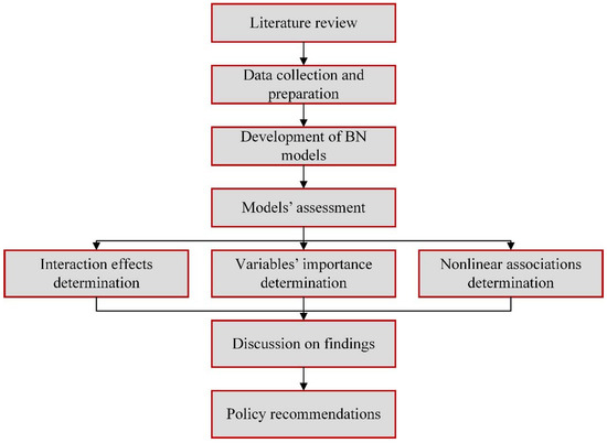
Several previous studies examined the variables of public-transit-related walking and privately owned vehicles (POVs) to go to work. However, most studies neglect the possible non-linear relationships between these variables and other potential variables. Using the 2017 U.S. National Household Travel Survey, we employ the Bayesian Network algorithm to evaluate the non-linear and interaction impacts of health condition attributes, work trip attributes, work attributes, and individual and household attributes on walking and privately owned vehicles to reach public transit stations to go to work in California. The authors found that the trip time to public transit stations is the most important factor in individuals’ walking decision to reach public transit stations. Additionally, it was found that this factor was mediated by population density. For the POV model, the population density was identified as the most important factor and was mediated by travel time to work. These findings suggest that encouraging individuals to walk to public transit stations to go to work in California may be accomplished by adopting planning practices that support dense urban growth and, as a result, reduce trip times to transit stations.
Full article
►▼
Show Figures
Open AccessArticle
Nonlinear Relationships between Vehicle Ownership and Household Travel Characteristics and Built Environment Attributes in the US Using the XGBT Algorithm
by
Te Ma, Mahdi Aghaabbasi, Mujahid Ali, Rosilawati Zainol, Amin Jan, Abdeliazim Mustafa Mohamed and Abdullah Mohamed
Cited by 12 | Viewed by 2759
Abstract
In the United States, several studies have looked at the association between automobile ownership and sociodemographic factors and built environment qualities, but few have looked at household travel characteristics. Their interactions and nonlinear linkages are frequently overlooked in existing studies. Utilizing the 2017
[...] Read more.
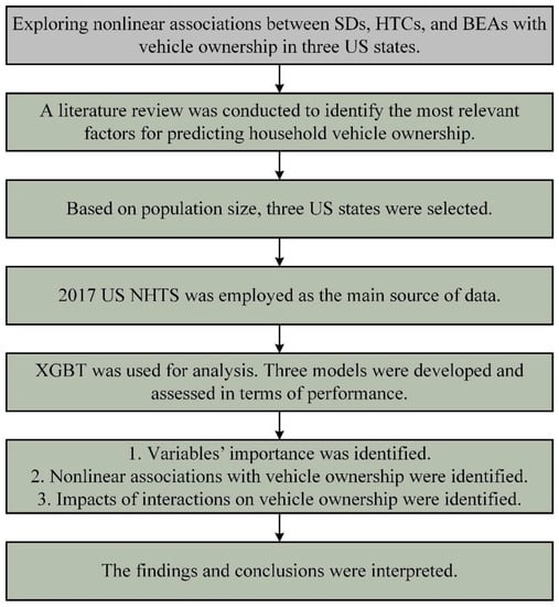
In the United States, several studies have looked at the association between automobile ownership and sociodemographic factors and built environment qualities, but few have looked at household travel characteristics. Their interactions and nonlinear linkages are frequently overlooked in existing studies. Utilizing the 2017 US National Household Travel Survey, the authors employed an extreme gradient boosting tree model to evaluate the nonlinear and interaction impacts of household travel characteristics and built environment factors on vehicle ownership in three states of the United States (California, Missouri, and Kansas) that are different in population size. To develop these models, three main XGBT parameters, including the number of trees, maximal depth, and minimum rows, were optimized using a grid search technique. In California, the predictability of vehicle ownership was driven by household travel characteristics (cumulative importance: 0.62). Predictions for vehicle ownership in Missouri and Kansas were dominantly influenced by sociodemographic factors (cumulative importance: 0.53 and 0.55, respectively). In all states, the authors found that the number of drivers in a household plays a vital role in the vehicle ownership decisions of households. Regarding the built environment attributes, deficiencies in cycling infrastructure were the most prominent attribute in predicting household vehicle ownership in California. This variable, however, has threshold connections with vehicle ownership, but the magnitude of these relationships is small. The outcomes imply that improving the condition of cycling infrastructure will help reduce the number of vehicles. In addition, incentives that encourage the households’ drivers not to buy new vehicles are helpful. The outcomes of this study might aid policymakers in developing policies that encourage sustainable vehicle ownership in the United States.
Full article
►▼
Show Figures
Open AccessArticle
An Advanced Machine Learning Approach to Predicting Pedestrian Fatality Caused by Road Crashes: A Step toward Sustainable Pedestrian Safety
by
Wenlong Tao, Mahdi Aghaabbasi, Mujahid Ali, Abdulrazak H. Almaliki, Rosilawati Zainol, Abdulrhman A. Almaliki and Enas E. Hussein
Cited by 29 | Viewed by 4453
Abstract
More than 8000 pedestrians were killed due to road crashes in Australia over the last 30 years. Pedestrians are assumed to be the most vulnerable users of roads. This susceptibility of pedestrians to road crashes conflicts with sustainable transportation objectives. It is critical
[...] Read more.
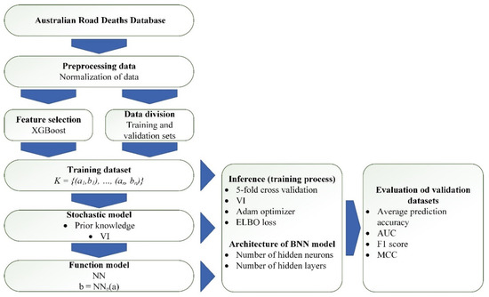
More than 8000 pedestrians were killed due to road crashes in Australia over the last 30 years. Pedestrians are assumed to be the most vulnerable users of roads. This susceptibility of pedestrians to road crashes conflicts with sustainable transportation objectives. It is critical to know the causes of pedestrian injuries in order to enhance the safety of these vulnerable road users. To achieve this, traditional statistical models are used frequently. However, they have been criticized for their inflexibility in handling outliers and missing or noisy data, and their strict pre-assumptions. This study applied an advanced machine learning algorithm, a Bayesian neural network, which has the characters of both Bayesian theory and neural networks. Several structures of this model were built, and the best structure was selected, which included three hidden neuron layers—sixteen hidden nodes in the first layer and eight hidden nodes in the second and third layers. The performance of this model was compared with the performances of some other machine learning techniques, including standard Bayesian networks, a standard neural network, and a random forest model. The Bayesian neural network model outperformed the other models. In addition, a study on the importance of the features showed that the individuals’ characteristics, time, and circumstantial factors were essential. They greatly increased model performance if the model used them. This research lays the groundwork for using machine learning approaches to alleviate pedestrian deaths caused by road accidents.
Full article
►▼
Show Figures
Open AccessArticle
Applying Machine Learning to Explore Feelings about Sharing the Road with Autonomous Vehicles as a Bicyclist or as a Pedestrian
by
Zohreh Asadi-Shekari, Ismaïl Saadi and Mario Cools
Cited by 6 | Viewed by 2244
Abstract
The current literature on public perceptions of autonomous vehicles focuses on potential users and the target market. However, autonomous vehicles need to operate in a mixed traffic condition, and it is essential to consider the perceptions of road users, especially vulnerable road users.
[...] Read more.
The current literature on public perceptions of autonomous vehicles focuses on potential users and the target market. However, autonomous vehicles need to operate in a mixed traffic condition, and it is essential to consider the perceptions of road users, especially vulnerable road users. This paper builds explicitly on the limitations of previous studies that did not include a wide range of road users, especially vulnerable road users who often receive less priority. Therefore, this paper considers the perceptions of vulnerable road users towards sharing roads with autonomous vehicles. The data were collected from 795 people. Extreme gradient boosting (XGBoost) and random forests are used to select the most influential independent variables. Then, a decision tree-based model is used to explore the effects of the selected most effective variables on the respondents who approve the use of public streets as a proving ground for autonomous vehicles. The results show that the effect of autonomous vehicles on traffic injuries and fatalities, being safe to share the road with autonomous vehicles, the Elaine Herzberg accident and its outcome, and maximum speed when operating in autonomous are the most influential variables. The results can be used by authorities, companies, policymakers, planners, and other stakeholders.
Full article
►▼
Show Figures
Open AccessArticle
Hybrid Bayesian Network Models to Investigate the Impact of Built Environment Experience before Adulthood on Students’ Tolerable Travel Time to Campus: Towards Sustainable Commute Behavior
by
Yu Chen, Mahdi Aghaabbasi, Mujahid Ali, Sergey Anciferov, Linar Sabitov, Sergey Chebotarev, Karina Nabiullina, Evgeny Sychev, Roman Fediuk and Rosilawati Zainol
Cited by 11 | Viewed by 3580
Abstract
This present study developed two predictive and associative Bayesian network models to forecast the tolerable travel time of university students to campus. This study considered the built environment experiences of university students during their early life-course as the main predictors of this study.
[...] Read more.
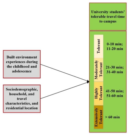
This present study developed two predictive and associative Bayesian network models to forecast the tolerable travel time of university students to campus. This study considered the built environment experiences of university students during their early life-course as the main predictors of this study. The Bayesian network models were hybridized with the Pearson chi-square test to select the most relevant variables to predict the tolerable travel time. Two predictive models were developed. The first model was applied only to the variables of the built environment, while the second model was applied to all variables that were identified using the Pearson chi-square tests. The results showed that most students were inclined to choose the tolerable travel time of 0–20 min. Among the built environment predictors, the availability of residential buildings in the neighborhood in the age periods of 14–18 was the most important. Taking all the variables into account, distance from students’ homes to campuses was the most important. The findings of this research imply that the built environment experiences of people during their early life-course may affect their future travel behaviors and tolerance. Besides, the outcome of this study can help planners create more sustainable commute behaviors among people in the future by building more compact and mixed-use neighborhoods.
Full article
►▼
Show Figures
Open AccessArticle
Connectivity in Superblock Street Networks: Measuring Distance, Directness, and the Diversity of Pedestrian Paths
by
Martin Scoppa and Rim Anabtawi
Cited by 11 | Viewed by 3069
Abstract
Superblocks are a common urban development strategy used in cities of the United Arab Emirates and the larger Gulf region. In planning new neighborhoods, these cities utilize superblocks structured using various street network designs. Despite their key role in shaping its main transportation
[...] Read more.
Superblocks are a common urban development strategy used in cities of the United Arab Emirates and the larger Gulf region. In planning new neighborhoods, these cities utilize superblocks structured using various street network designs. Despite their key role in shaping its main transportation network, the connectivity of these designs has not been frequently studied. This paper addresses this research gap, analyzing ten different superblock designs, and focusing on their internal and external connectivity properties. Internal connectivity is studied by measuring connections between plots in the superblocks. External connectivity is measured from plots to the superblocks’ corners, the points from which to access surrounding areas. Connectivity is measured in terms of distance, directness, and route diversity. The results show that strong similarities exist across the studied designs, particularly in terms of travel distances. Differences are found in terms of efficiency and, most notably, route diversity. Findings are discussed in relation to walkability, the costs associated to each design given network length variations, and the importance of creating rich and diverse street systems that support open-ended exploration. While based on a sample of ideal cases and in need of validation with built cases, this paper outlines a method by which to evaluate and compare superblock network design alternatives.
Full article
►▼
Show Figures
Open AccessArticle
Measurement Quality Appraisal Instrument for Evaluation of Walkability Assessment Tools Based on Walking Needs
by
Sanaz Tabatabaee, Mahdi Aghaabbasi, Amir Mahdiyar, Rosilawati Zainol and Syuhaida Ismail
Cited by 7 | Viewed by 2827
Abstract
Walking is a sustainable commute mode, and walkability is considered an essential sign of sustainable mobility. To date, many walkability assessment tools have been developed to assess the walkability conditions across the world. However, there is a paucity of comprehensive methods to assess
[...] Read more.
Walking is a sustainable commute mode, and walkability is considered an essential sign of sustainable mobility. To date, many walkability assessment tools have been developed to assess the walkability conditions across the world. However, there is a paucity of comprehensive methods to assess current walkability tools based on walking needs and ensure all walking requirements are included. Thus, researchers and experts are unable to select the most comprehensive tool systematically. The present study attempts to develop a system to evaluate the quality of the existing tools. The instrument focuses on factors related to walking needs frequently observed in all types of walkability assessment tools. Hence, a pilot measurement quality appraisal instrument (MQAI) is developed and tested by a research team with planning and public health backgrounds. The final MQAI is tested by suitable reliability, criterion, and content validity tests. Most appraisal scales display moderate to high reliability for both audits and questionnaires. The MQAI appears as ready for use in several applications, including meta-analyses and systematic reviews. Additionally, the MQAI can be used by practitioners and planners to identify the most comprehensive and efficient assessment tools based on their needs.
Full article
►▼
Show Figures
Open AccessArticle
Guidance and Practice in Planning Cycling Facilities in Europe—An Overview
by
Bettina Schröter, Sebastian Hantschel, Caroline Koszowski, Ralph Buehler, Paul Schepers, Johannes Weber, Rico Wittwer and Regine Gerike
Cited by 9 | Viewed by 3714
Abstract
The provision of convenient, safe and seamless facilities for cyclists is one core success factor in promoting cycling as a mode of transport. Cycling infrastructures and planning philosophies differ greatly between countries, but there is no systematic overview or comparison of similarities and
[...] Read more.
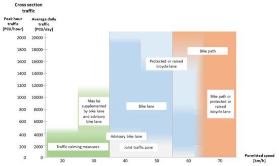
The provision of convenient, safe and seamless facilities for cyclists is one core success factor in promoting cycling as a mode of transport. Cycling infrastructures and planning philosophies differ greatly between countries, but there is no systematic overview or comparison of similarities and dissimilarities. The aim of this study is to provide an in-depth international overview of guidance material for cycling facilities in European countries and to develop recommendations for advancing provisions for cyclists. International guidance materials for cycling facilities along street sections are collated, systemised and compared. For researchers, the findings provide background information to better understand cycling behaviour and safety. For planners, the findings support their efforts to support cycling and to improve guidance materials. The results show that, in general, countries that are just beginning to promote cycling tend to offer a greater variety of cycling infrastructures in their guidance materials than more mature cycling countries. Countries differ in whether they prefer to put cyclists on the street level or on the sidewalk and whether they mix cyclists with other user groups in the same space. There was even greater variability among countries in the criteria for selecting types of cycling facilities than in the design characteristics (width, buffer zones, etc.).
Full article
►▼
Show Figures
Open AccessArticle
Built Environment Determinants of Pedestrian Activities and Their Consideration in Urban Street Design
by
Regine Gerike, Caroline Koszowski, Bettina Schröter, Ralph Buehler, Paul Schepers, Johannes Weber, Rico Wittwer and Peter Jones
Cited by 23 | Viewed by 6600
Abstract
Pedestrian facilities have been regarded in urban street design as “leftover spaces” for years, but, currently, there is a growing interest in walking and improving the quality of street environments. Designing pedestrian facilities presents the challenge of simultaneously accommodating (1) pedestrians who want
[...] Read more.
Pedestrian facilities have been regarded in urban street design as “leftover spaces” for years, but, currently, there is a growing interest in walking and improving the quality of street environments. Designing pedestrian facilities presents the challenge of simultaneously accommodating (1) pedestrians who want to move safely and comfortably from point A to B (movement function); as well as (2) users who wish to rest, communicate, shop, eat, and enjoy life in a pleasant environment (place function). The aims of this study are to provide an overview of how the task of designing pedestrian facilities is addressed in international guidance material for urban street design, to compare this with scientific evidence on determinants of pedestrian activities, and to finally develop recommendations for advancing provisions for pedestrians. The results show that urban street design guidance is well advanced in measuring space requirements for known volumes of moving pedestrians, but less in planning pleasant street environments that encourage pedestrian movement and place activities. A stronger linkage to scientific evidence could improve guidance materials and better support urban street designers in their ambition to provide safe, comfortable and attractive street spaces that invite people to walk and to stay.
Full article
Open AccessArticle
Hierarchical Longitudinal Control for Connected and Automated Vehicles in Mixed Traffic on a Signalized Arterial
by
Xiao Xiao, Yunlong Zhang, Xiubin Bruce Wang, Shu Yang and Tianyi Chen
Cited by 5 | Viewed by 2233
Abstract
This paper proposes a two-layer hierarchical longitudinal control approach that optimizes travel time and trajectories along multiple intersections on an arterial under mixed traffic of connected automated vehicles (CAV) and human-driven vehicles (HV). The upper layer optimizes the travel time in an optimization
[...] Read more.
This paper proposes a two-layer hierarchical longitudinal control approach that optimizes travel time and trajectories along multiple intersections on an arterial under mixed traffic of connected automated vehicles (CAV) and human-driven vehicles (HV). The upper layer optimizes the travel time in an optimization loop, and the lower layer formulates a longitudinal controller to optimize the movement of CAVs in each block of an urban arterial by applying optimal control. Four scenarios are considered for optimal control based on the physical constraints of vehicles and the relationship between estimated arrival times and traffic signal timing. In each scenario, the estimated minimized travel time is systematically obtained from the upper layer. As the results indicate, the proposed method significantly improves the mobility of the signalized corridor with mixed traffic by minimizing stops and smoothing trajectories, and the travel time reduction is up to 29.33% compared to the baseline when no control is applied.
Full article
►▼
Show Figures


