


Water 2026, 18(14), 1749; https://doi.org/10.3390/w18141749 - 19 Jul 2026
Abstract
To investigate the dynamic transmission of unsteady hydraulic excitation within pumped-storage units, this study presents a numerical investigation on the three-dimensional shafting vibrations of a pump-turbine based on a one-way transient fluid-structure interaction approach. To resolve the flow field, we adopt the shear
[...] Read more.
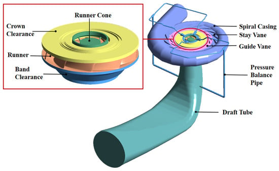
To investigate the dynamic transmission of unsteady hydraulic excitation within pumped-storage units, this study presents a numerical investigation on the three-dimensional shafting vibrations of a pump-turbine based on a one-way transient fluid-structure interaction approach. To resolve the flow field, we adopt the shear stress transport (SST) k-ω turbulence model in conjunction with the Zwart-Gerber-Belamri (ZGB) cavitation model, and the combined numerical approach is first calibrated against experimental measurements. The results indicate that under the 70% partial load, an eccentric helical vortex rope develops inside the draft tube, generating intense low-frequency pressure pulsations that induce chaotic shaft orbits and distinct orbital drift at the turbine guide bearing. Conversely, near the optimal efficiency point (90% load), the vortex rope transitions into a slender, straight conical core, yielding minimum vibration magnitude and exceptional operational stability. At the 100% rated load, the vortex rope expands into a robust straight conical structure extending continuously into the elbow section. Stress analysis reveals that while equivalent stress concentrations consistently occur at the blade root regions, a reduction in the cavitation number at both 90% and 100% loads leads to a counterintuitive decline in blade surface peak stress values. Additionally, stiffness sensitivity analysis demonstrates that the relative change rates of the shaft runout are highly sensitive to the stiffness variations of the turbine guide bearing, where a stiffness reduction triggers a substantial runout growth of approximately 100% along the X- and Y-directions, whereas the variations in the upper and lower guide bearings exert extremely weak impacts.
Full article
(This article belongs to the Section Hydraulics and Hydrodynamics)
►
Show Figures
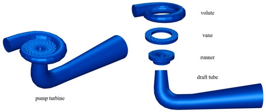
Figure 1


