Drivers of Wildfire Occurrence Patterns in the Inland Riverine Environment of New South Wales, Australia


1
College of Transport and Communications, Shanghai Maritime University, Shanghai 201306, China
2
School of Civil and Environmental Engineering, The University of New South Wales, Sydney, NSW 2052, Australia
*
Author to whom correspondence should be addressed.
Forests 2019, 10(6), 524; https://doi.org/10.3390/f10060524
Submission received: 27 March 2019
/
Revised: 18 June 2019
/
Accepted: 21 June 2019
/
Published: 24 June 2019
(This article belongs to the Special Issue Fire Effects and Management in Forests)
Abstract
:In the inland riverine environment of Australia, wildfires not only threaten human life and cause economic loss but also make distinctive impacts on the ecosystem (e.g., injuring or killing fire-sensitive wetland species such as the river red gum). Understanding the drivers of wildfire occurrence patterns in this particular environment is vital for fire-risk reduction and ecologically sustainable management. This study investigated patterns and driving factors of wildfire occurrence over the years from 2001 to 2016 and across the New South Wales side of the Riverina bioregion. Descriptive analyses were conducted for fires of different causes and that burned different vegetation types. Logistic regression models were developed by incorporating factors that provide information on weather, climate, fuel, topography and ignition sources. Analyses revealed that most fires occurred in summer, with human-caused fires primarily in spring and summer, and natural fires in summer. Summer was the most fire-prone season in forested wetlands, whereas fires in drylands mostly occurred during spring and summer. Fire probabilities were higher under severe weather conditions, in areas with higher annual rainfall, in forested wetlands and in areas with intermediate inundation frequencies. Special attention needs to be paid to the effects of vegetation type and inundation frequency on fire occurrence. Weather, climate&fuel and ignition sources were comparably important in explaining human-caused fire occurrence, whereas weather was more important than climate&fuel in explaining natural fire occurrence. Understandings obtained from this study can potentially support the planning of fire and forest management, as well as to supplement the relatively scarce knowledge on riverine wildfire occurrence.
1. Introduction
Wildfires can significantly affect the ecological process, threaten human life and cause substantial socio-economic impacts [1,2,3]. In the semi-arid riverine plain of Australia, fires burn both the temporal wetlands and their surrounding dry lands. Although fires that burned in the wetlands might be a minority in general, they are of significant importance for the ecology in this area. For example, these fires may lead to seed loss, change in vegetation composition and soil and channel bank erosion [4,5]. They may also affect the fire-sensitive vegetation such as Eucalyptus camaldulensis Dehnh. (known as river red gum), a typical Australian inland riverine species. Fires that occurred in the inland riverine environment; therefore, deserve special attention. Understandings of the occurrence patterns and their determinants in the inland riverine environment can support detailed fire-risk reduction practices in the forested wetlands, and assist in the development of more effective regional conservation plans and management strategies.
At regional and daily scales, the occurrence of wildfires is regulated by weather conditions, fuel type, fuel moisture, topographic condition and ignition sources [1,6]. Weather observations such as temperature, relative humidity and precipitation; and derived indices such as moisture content of fuel, drought condition and the level of fire danger, regulate the chance of a fire by providing the preferable moisture condition suitable for ignition [1,7,8,9]. The fuel moisture content can be assessed by a simple fuel moisture index (FMI) that is derived from temperature, relative humidity and the estimated amount of moisture contained in fine fuel [10]. The degree of drought and the dryness of the soil can be represented by a soil moisture deficit index, known as the Keetch–Byram drought index (KBDI) [11]. KBDI can be used to derive the forest fire danger index (FFDI), a measure of forest fire danger that is primarily used in Australia [12,13]. Wildfire occurrence is also regulated by the type of fuel and vegetation, the frequency of inundation, the proximity to a waterway as well as the long-term climatic factors, such as the annual rainfall, because of their associations with the load, moisture and flammability of fuel [14,15,16,17,18,19]. Topography drives fire occurrence patterns by affecting the general and micro weather patterns, as well as influencing the moisture and availability of fuel [20,21,22]. The occurrence patterns of human-caused and natural fires are normally affected by different processes: Human-caused fires are mostly affected by factors related to the accessibility to anthropogenic activities and the presence of protective management [17,23,24,25,26], whereas natural fire occurrence can be regulated by the occurrence of lightning strikes [17,25,27,28].
Studies on the wetland (or riparian) fires revealed that riparian fire occurrence and frequency vary across different regions and vegetation types. According to the logical argument of the Country Fire Authority [29], wildfires are less likely to ignite from the forested riparian areas than other areas due to the less likelihood of lightning strikes, the restrictiveness of human accessibility, the patchiness of fuel as well as the limited fuel amount and high fuel moisture. This argument can be confirmed by findings in wetter forested ecosystems located in mountain areas or national parks in the United States (US), where fires were found to occur less frequently in riparian forests than in adjacent uplands [30,31,32]. In the drier forest types of the US, fires generally burned at similar frequencies in riparian stands and uplands [33]. Similar characteristics have been found in the Canadian Rocky Mountains, where lands adjacent to streams are less likely to burn than the uplands [34]. However, in a low rainfall floodplain in Africa, the frequency of fires was found to be higher on floodplains than uplands because of higher biomass production [35]. Nevertheless, studies investigating the characteristics of wetland or riparian fires were rare both in Australia or around the world [36]. Specifically, the occurrence pattern of this sort of fire was very rarely studied in semi-arid areas and; therefore, needs to be further explored.
The fuel accumulation and drying-out mechanisms in the wetland areas are not always the same as those in upland areas due to the interactive relationship between fires and floods. The high availability of water in riparian areas results in high net primary productivity and the associated fuel load [37]. Additionally, the pulling up and deposition of riparian trees that were found during large flood events contribute to the subsequent accumulation of woody fuel and thus increase the fire risk in the semi-arid Sabie River of South Africa [38]. The destruction of trees by a flood also leads to the exposure of fuel to greater radiant heat that accelerates the drying-out procedure for fuel [39]. The higher load and faster drying-out of fuel is expected to lead to a higher fire risk; however, frequent flooding will inhibit the growth of vegetation and the accumulation of fuel, thus reducing the fire risk; therefore, Pettit and Naiman [18] suspected a non-linear relationship between fire frequency and flood frequency (i.e., the fire frequency is highest at an intermediate flooding frequency). The relationship between inundation and fire occurrence in the semi-arid inland riverine environment of Australia is not well understood.
The objective of the present study is to identify patterns of wildfire occurrence and their drivers in the New South Wales (NSW) side of the Riverina Bioregion. A number of human-caused and natural wildfires occurr in this area every year, allowing for the quantitative analysis on a causality basis. To achieve the above-mentioned objective, the authors built logistic regression models that estimate occurrence probabilities of both human-caused and natural fires, utilizing historical fire records together with factors that provide information on weather, fuel, topography and ignition sources. More specifically, this study aims to address the following questions: (1) What are the spatial and temporal patterns of human-caused and natural wildfire occurrence. (2) What are the effects of weather and fuel on these patterns? Plus, (3) what are the relative contributions of fire occurrence drivers? Insights obtained from this work can potentially lead to a better understanding of the driving forces of fires in the Riverina and assist in management and protection of this unique ecological system.
2. Materials and Methods
2.1. Study Area
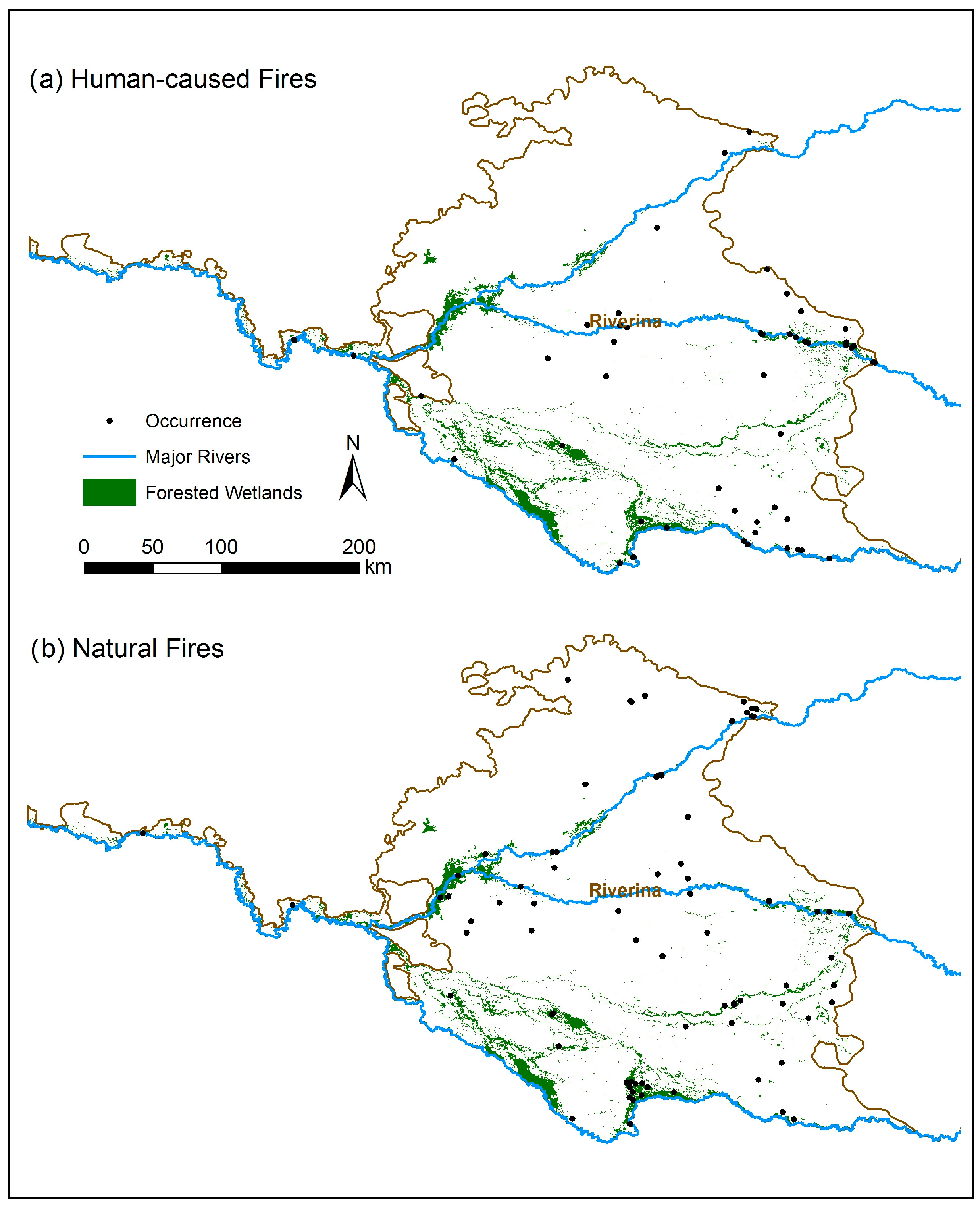
The Riverina Bioregion, referred to as the “Riverina” in the present work, is an area of 97,000 km2 that covers part of NSW, Victoria and South Australia. The study area (Figure 1) is the NSW portion of the Riverina that is located approximately between 141.0° E–147.0° E and 33.0° S–36.0° S and covers an area of 70,000 km2 [40]. Extensive riverine plains are developed as a result of the Murray River and the Murrumbidgee River, and their tributaries, flowing across the landscape; this forms an area of approximately 9000 km2 of wetlands. Within the wetland region, an area of 4000 km2 is “forested wetlands”, a vegetation formation dominated by sclerophyllous trees 5–40 m tall with an understorey of hydrophytic species [41,42]. Forested wetlands grow along the major channels and floodplains and take up 5.6% of the study area.
The study area experiences warm, dry summers and cool winters, and the season of rainfall is typically in May and September [43]. Both semi-arid and mesic climates exist in this area; the average annual rainfall increased easterly from approximately 240 to 680 mm, as calculated by the authors. The elevation also increases easterly from sea level to 130 m. The vegetation distribution changes in accordance with the accessibility of water and the above-mentioned spatial variations in climate and geomorphic setting [43,44]. Vegetation structure varies from an eucalypt open forest with a shrubby understorey to an eucalypt woodland with a tussock grass understorey [45]. Vegetation communities in wetland areas include river red gum forests and black box (Eucalyptus largiflorens F.Muell.) forests, box woodlands, shrublands, grasslands and swamp communities [40,41]. The rest of the Riverina is upslope from the watercourse and is either cleared or dominated by shrubs, forbs, grasses and herbs [42,45].
2.2. Datasets
All explanatory variables used in the present work are listed in Table 1. These variables were subdivided into four groups: weather, climate&fuel, topography and ignition sources. The weather group included seven variables: Maximum Temperature, Minimum Temperature, Relative Humidity 3 pm, FMI, KBDI, FFDI and Days since Rain. The first three variables represent the maximum temperature, minimum temperature, as well as the relative humidity for a day. They were obtained from 121 weather stations [46] in the Riverina and its neighbouring regions. Specific fire records were assigned to the nearest station that has complete weather records across its entire burning period. A number of moisture, drought and fire danger indexes—FMI, KBDI, FFDI—were derived from the weather records. Since FMI is highly dynamic [47], the averaged FMI of a day was used. Daily KBDI was calculated according to the equations presented by Keetch and Byram [11], and FFDI was derived following the work of McArthur [12] and Noble, et al. [48]. The variable Days since Rain that represents the number of days since the last rain day was also derived from weather records.
The climate&fuel group included four variables: Annual Rainfall, Wetland, Inundation Frequency and Distance to Drainage Line. The Annual Rainfall variable represented the mean value of annual rainfall from 2002 to 2016, which was constructed by aggregating the amount of monthly rainfall totals [49] of each year and then calculating the yearly mean value. This variable was assigned to the climate&fuel group because it synthesises annual weather conditions and is a representative of the rate of biomass accumulation. The map distinguishing forested wetlands from other vegetation formations was derived from the version 3.03 of the NSW vegetation formation map [50]. A binary variable (Wetland) was generated to represent whether a site was located in forested wetlands. The variable Inundation Frequency was constructed from a water prevalence map that was created by calculating the proportions of water-presented observations in the NSW inundation count dataset [51]. The inundation count dataset itself was produced by applying a new water index to each Landsat acquisition from mid-1984 to mid-2016 using the technique developed by Fisher et al. [52]. The variable Distance to Drainage Line was generated by calculating the Euclidean distance to the nearest drainage line; the drainage line layer was extracted from 1:250,000 topographic data, GEODATA TOPO 2.5 M 2003 [53]. Wetland, Inundation Frequency and Distance to Drainage Line were also assigned to the climate&fuel group because of their connections with fuel load and moisture content.
The topography group included three variables: Elevation, Slope and Northwestness. The elevation layer was extracted from the Global Digital Elevation Map generated from the Advanced Spaceborne Thermal Emission and Reflection Radiometer [54]. Slope and Northwestness (the aspect relative to the north-west) were calculated from the elevation layer. The ignition source group includes Distance to the wildland–urban interface (WUI), Distance to Road, as well as Protected Area that represent whether the site is located in a protected area. The protected area layer was derived from the Collaborative Australian Protected Areas Database [55]. The WUI was defined as the boundary between wildlands and urban areas; the WUI layer was generated from the land cover map [56]. The road layer was extracted from GEODATA TOPO 2.5 M 2003 [53]. Both of the two distance maps were generated by calculating the Euclidean distances to the respective layers.
The fire datasets contain fire observations for the state of NSW from 1902 to 2016 maintained by the NSW OEH [57] and the NSW Rural Fire Service (RFS) [58]. The positional uncertainty of fire boundaries varied from 10 to 100 m [59]. Only records within the Riverina bioregion were used. Planned burning scars and duplicate records were removed. Because fire records obtained from NSW RFS have only been consistently captured or updated from the 2001/2002 fire season forward [58], those from pre 2001 were excluded, resulting in a total of 157 fire records, including 43 human-caused fire records and 72 natural fire records (Table 2).
Since the actual location where a fire event started is unknown, a given fire could have been ignited anywhere within the fire event polygon. Fires were classified into three categories based upon the degree of event polygon overlap with wetlands: fires burned entirely in forested wetlands (FEW); fires burned partly in forested wetlands (FPW); and fires not burned in forested wetlands (FNW). For fires that belonged to the FPW category, it was not clear whether they were ignited from or spread into forested wetlands; therefore, this category was used only for descriptive analysis and was not used to build logistic regression models. Fire observations with unknown causes were subsequently excluded because their presence may have masked the effects of important fire drivers in the models. This resulted in a total of 85 fire samples eligible for the quantitative analysis, including 49 natural fires and 36 (suspected) human-caused fires (Table 2). The spatial distributions of fires of both causes are depicted in Figure 1, with fire locations represented by their centroid points.
2.3. Methods
Descriptive analyses were conducted for each fire cause (i.e., human-caused, natural and unknown) and category (i.e., FEW, FNW and FPW) to explore the monthly and seasonal distributions of fire occurrence. Pearson’s χ2 tests were conducted to test whether the seasonal distribution of fires was independent of cause or category at the 0.05 significance level. Logistic regression models were used to compare the probability of fire ignition with random points. In order to determine whether the variables listed in Table 1 affected the occurrence of fires differently than what would be expected by chance [24], all ignition points were used; 400 points were allocated to random dates and sites for the regression analysis.
Univariate logistic regression models were built to quantify relationships between the fire occurrence probability and its explanatory variables, as well as to find out the most appropriate variables for inclusion in the multiple regression models. According to Vittinghoff and McCulloch [60], the number of “cases” (fire incidents) per independent variable should range from at least five to nine, therefore the maximum number of independent variables in the multiple logistic regression models was set to 85/9 ≈ 9 for all fires, 49/9 ≈ 5 for natural fires and 36/9 ≈ 4 for human-caused fires. The original representation of Inundation Frequency was not significant in either univariate or multiple regression models; therefore, the square, natural logarith, and fourth root of the variable were tested. Of these, the fourth root was significant and better fit the data, so that it was included in the model development. To avoid the influence of multicollinearity, variables with a Spearman’s rank correlation of greater than 0.6 [61] (e.g., Annual Rainfall and Elevation) or variables that were generated from another variable (e.g., FFDI was generated from Maximum Temperature) were not included in the same model.
The multiple logistic regression models were built using a backwards stepwise algorithm [62] based on Akaike information criterion (AIC) [63] (i.e., explanatory variables were iteratively dropped if the model had a smaller AIC without them). All first order interactions were tested as well, and none were found to be significant. There was no evidence of spatial autocorrelations according to the semivariograms of the models’ deviance residuals. The goodness of fit was measured with the percentage of deviance explained, as well as the area under the curve (AUC) of the receiver operating characteristics (ROC) curve. Three models were explored for each cause of a fire: the best model (i.e., the model that explained the most deviance and had the highest AUC) and models that included and excluded Inundation Frequency. The contribution of each variable group to the best model was estimated with a jackknife procedure according to the change in AUC [64]. The effect and contribution of Inundation Frequency on fire occurrence probability were examined by graphically plotting the model including Inundation Frequency and comparing the goodness of fit of the latter two.
3. Results
Regardless of their causes and the vegetation types burned, fires mostly occurred in summer, specifically in December and January; this also applies to the seasonality of natural fires (Figure 2a,b). Human-caused fires mostly occurred during spring, followed by summer, with the largest number of fires occurring in October, November and December. The largest number of FEW and FPW were found in summer (especially December and January), while FNW mostly occurred in spring and summer, especially November and December (Figure 2c,d). The P values from Pearson’s χ2 tests were 0.01 for fire seasonality against fire cause and 0.001 for fire seasonality against fire category. These results indicate that there were significant differences in terms of fire seasonality among the different fire categories and causes.
All variables with significant effect in univariate models are listed in Table 3. Most variables in the groups of weather and climate&fuel were significant at the 0.05 level in explaining the probability of fire occurrence, except for Days since Rain (P = 0.11) and Distance to Drainage (P = 0.39) for human-caused fire, as well as KBDI for both human-caused and natural fires (P = 0.32 and P = 0.79). Elevation was the only significant topographic variable. Some variables in the ignition source group (i.e., Distance to WUI and Distance to Road) were significant in explaining human-caused fire occurrence but did not explain natural fire occurrence.
Among significant variables in the univariate models, positive relationships were found between the probability of fire occurrence and variables such as Maximum Temperature, Minimum Temperature, FFDI, Days since Rain, Annual Rainfall, the fourth root of Inundation Frequency, and Elevation. Negative relationships were found between the fire occurrence probability and all other variables. The results showed that fires were more likely to occur in wetlands than lands with other vegetation types.
The best-performing model for human-caused fire occurrence contained one weather variable (Maximum Temperature), two climate&fuel variables (Annual Rainfall and Wetlands) and two ignition source variables (Distance to WUI and Distance to Road), explaining 34% of the deviance with an AUC value of 0.88 (Table 4, Table 5). The best-performing model for natural fire occurrence contained the same weather and climate&fuel variables, and had an AUC of 0.89 and explained deviance of 34% (Table 4, Table 5).
The variable importance (Figure 3) for the best model of human-caused fires showed that each factor group contributes to the final model at approximately the same level; the AUC values of models without weather, climate&fuel or ignition sources were 0.85, 0.84 and 0.85, respectively. For natural fires, the model without weather variables had an AUC far less than for the model without climate&fuel variables (0.71 vs. 0.84), indicating that weather contributed more than climate&fuel in explaining the occurrence of natural fires.
Models including the fourth root of Inundation Frequency exhibited an AUC of 0.86 for human-caused fires and 0.89 for natural fires, the performances of which were considerably better than models without Inundation Frequency (AUC = 0.84 for human-caused fire and AUC = 0.87 for natural fire, as shown in Table 4). Graphs depicting the change of the fire probability in relation to selected variables (Figure 4) indicated that the fire probability increased as Maximum Temperature increased, and that this effect became stronger at higher Inundation Frequency values (Figure 4a,b). Fire probability and Inundation Frequency had a positive and non-linear relationship; the slope was steeper at lower Inundation Frequency than at higher values (Figure 4c,d).
4. Discussion
4.1. The Spatial and Temporal Pattern of Wildfire Occurrence
Most fires in the Riverina bioregion occurred during summer, consistent with the peak fire season of this area [13]. In this bioregion, the conditions most preferable for fire ignition occur during summer when the weather is hot and dry, the average temperature is over 30 °C, and rainfall occurs less reliably [43]. Seasonal inundation patterns may also regulate fire seasonality: In the riverine environment, fires are very unlikely to occur during winter inundation phases. However, fires caused by different processes have different seasonality. Natural fires are mostly ignited in summer (especially December and January), probably because of lightning strikes associated with summer thunderstorms [43]. Human-caused fires have slightly extended seasonality, with fires mostly occurring in spring and summer (especially October, November and December). This difference in fire seasonality is generally consistent with findings of Jennifer K. Balch et al. that indicated that lightning fires were clustered in the summer while human-caused fires have extended fire season across the United States [70], although their study also recognized prescribed fires and crop fires. The extended seasonality may be because that human-caused fires can be ignited during days without thunderstorms and under relatively higher fuel moisture conditions compared with lightning-started fires.
Both FEW and FPW categories tended to ignite in December and January, whereas FNW events mostly ignited in November and December. This reflects the difference between fire activity in temperate eucalypt forests/woodlands and in semi-arid chenopod shrublands; the former is dominated by summer fires and the latter by spring-summer fires [71,72].
Both human-caused and natural fires were found to be more likely to be ignited on days with severe weather conditions (higher temperature and fire danger index, lower relative humidity and fuel moisture content), in areas with higher levels of annual rainfall, in forested wetlands, as opposed to the surrounding dry lands, and in areas with intermediate inundation frequencies. Human-caused fires were more likely to occur near urban areas and transportation facilities.
4.2. Effects and Relative Importance of Driving Factors
The observed effects of ambient weather conditions were generally consistent with those found at a broader scale [73] and in other landscapes [17]. The insignificant contribution of KBDI to the occurrence of both types of fires can be explained by the nature of fuels in Riverina. In this semi-arid environment, where woody plant cover is inherently sparse, ephemeral and perennial grass is the dominant fuel type [74,75]. Although the drought condition represented by KBDI is expected to be related to the availability to burn litter fuels in forested systems, it lacks the capacity in explaining the ignition of grass fires, the fuels of which are frequently dry enough to burn [71,74].
Wildfire activity varies with different climatic conditions [73,76]. In a semi-arid landscape, the rainfall gradient is an indicator of fuel amount (productivity): The greater the average annual rainfall, the higher the biomass production, and, consequently, the higher the probability of fire occurrence [71]. Accordingly, fire probability was found to be higher in the south-eastern part of the Riverina while lower in the far west; this paralleled productivity, and conforms to findings in other semi-arid landscapes [77].
Results showed that regardless of cause, fires are more likely to start in forested wetlands than in drylands, which is inconsistent with the fire–vegetation relationship found in studies of temperate zones; these studies have documented lower or equal frequency of fire in riparian/wetland areas compared with adjacent uplands/drylands [18,30,31,33,37,78]. This discrepancy is probably determined by the semi-arid climate of the Riverina and the larger quantity of fuel in its wetlands. Riparian zones generally have higher fuel loads due to the promotion of high biomass production by better water accessibility, the accumulation of wrack and woody fuels in channels produced by uprooted and redistributed trees and the harvest of riparian trees [18]. These factors apply to both dry and wet ecosystems. However, the semi-arid climate in this area accelerates the drying-out of inland riparian forests during the summer drought and non-inundation phase (Briggs 1988), providing favourable conditions for fires to start. This can be partially proved by the fact that wildfire season co-occurs with the drought and non-inundation period. A comparable result has been found in a tropical floodplain system of southern Africa, where fire frequency was higher in wetlands than for drylands [35]. The main vegetation formation in that study (savanna) was considerably different from that of the present study (forest); however, it does provide corroboration on the effect of productivity on fire occurrence in arid or semi-arid environments. It is notable that, although fires in the Riverina are more likely to occur in forested wetlands than drylands, these wetland fires appeared to be relatively smaller in size, both individually and in total. This is likely due to the low proportion of forested wetlands within the entire study area and the relatively high fuel moisture content associated with both water and forest environments [79]. A more comprehensive discussion of fire risk in this environment may; therefore, be needed to support sustainable management and ecological assessment practices.
At inundation frequencies equal to or below 0.5, fires were more likely to occur in areas with a higher inundation frequency. This fire–flood relationship can be explained by the fact that a higher inundation frequency may lead to a higher biomass production and also higher rates of uprooting and redistribution of woods, which result in higher fuel load. The relationship between these factors flattened out in areas that were more frequently inundated (i.e., nearer to rivers). This finding reflects the change of balance between biomass amount and its propensity to burn [71]. It also confirms the hypothesis that fire and flood frequencies follow a non-linear relationship [18]. No fires were recorded on lands with inundation frequencies greater than 0.5, which may mean that fires are very unlikely to occur on these less-inundated lands. It is suspected that at an inundation frequency greater than 0.5 the fire occurrence probability will decline with more frequent floods, as fires are least likely to occur near areas that experience permanent inundation [80]. This speculation is supported by the finding of Heinl, Neuenschwander, Sliva and Vanderpost [35] that the highest fire frequencies occur at intermediate flood frequencies (i.e., every second year). However, more data is required to draw a more reliable conclusion.
The tendency for human-caused fires to occur near urban areas and transportation facilities is consistent with findings in other landscapes [17,23,81]. This result is not surprising because it illustrates the association between human activities and fire occurrence in wildlands or undeveloped areas: (1) The nearer to the urban areas, the higher degree human development (activity) intermingles with undeveloped vegetation, and (2) the nearer to transportation facilities, the better accessibility of human activities to wildlands. It also indicates the threat of wildfire to human lives and assets, which emphasises the importance of fire management strategies.
Weather, climate&fuel and ignition sources explained human-caused fire occurrence probability to approximately equal degrees. This means that allocation of suppression resources, fuel management activities and management of human accessibility are all essential factors for controlling human-caused fires. For natural fires, weather contributed more to the final model than climate&fuel, implying an association between extreme weather and lightning. Weather is; therefore, more important from the perspective of natural fire risk mitigation.
4.3. Limitations and Future Work
The present study has some limitations. First, natural fire occurrence is expected to be affected by the incidence of lightning strikes [82], hence it may be better modelled by introducing lightning-related factors. Second, the fire history dataset only recorded fires that had been investigated, which means that there might have been minor fires that were not included in the dataset. In addition, the geographical locations of ignition points were unknown; therefore, the factors used in the present study only represent the general conditions of when and where fires get started. Improvements can be made when more precise data regarding ignition points are available.
Using vegetation type as an explanatory variable in these models necessitates that fires ignited from different vegetation types be distinguished, and fires that burned multiple types (i.e., FPW) be discarded. Similarly, fires with unknown causes were excluded to avoid introducing noise to the final models. These filters might have excluded a number of potentially useful samples from the analysis. Future studies can look at fire patterns that do not distinguish fires by cause, and build models that do not contain vegetation type.
5. Conclusions
The present work illustrates a number of descriptive and quantitative analyses that provide better understandings of drivers of wildfire occurrence patterns in the NSW side of the Riverina. Attentions were paid to the spatial and temporal patterns of wildfire occurrence, the effects and relative importance of weather, climate&fuel, topography and ignition sources, and, especially, the effects of vegetation type and inundation frequency on the occurrence of wildfires.
Generally speaking, summer is the most fire-prone season for all fires. However, fires caused by different processes experienced slightly different seasonality: Natural fires mostly occurred in summer, especially in December and January, whereas human-caused fires mostly occurred in spring and summer, especially in October, November and December. FEW and FPW mostly occurred in summer, whereas FNW tended to occur during spring and summer. Fires also tended to occur under higher temperature and fire danger index, lower relative humidity and fuel moisture content, in areas with higher levels of annual rainfall, in forested wetlands as opposed to the surrounding drylands, and in areas with intermediate inundation frequencies. Additionally, human-caused fires were more likely to occur near urban areas and transportation facilities. Weather, climate&fuel and ignition sources contributed to human-caused fire occurrence at approximately the same levels, whereas weather was more important than climate&fuel in driving natural fire occurrence.
Insights obtained from this work can potentially provide regional and more detailed information on fire risk assessment and planning of this ecologically significant environment, which may also supplement the relatively scarce knowledge on fire patterns in forested wetlands and drylands in riverine environments around the world.
Author Contributions
Conceptualization, Y.Z. and S.L.; data curation, Y.Z.; formal analysis, Y.Z.; methodology: Y.Z. and S.L.; visualization, Y.Z.; writing—original draft preparation, Y.Z.; writing—review and editing, Y.Z. and S.L.; supervision, S.L.
Funding
This research received no external funding.
Acknowledgments
We would like to thank New South Wales Rural Fire Service for providing the fire history datasets, and the Office of Environment and Heritage for providing the fire history and vegetation type dataset.
Conflicts of Interest
The authors declare no conflicts of interest.
References
- Taylor, S.W.; Woolford, D.G.; Dean, C.B.; Martell, D.L. Wildfire prediction to inform fire management: Statistical science challenges. Stat. Sci. 2013, 28, 586–615. [Google Scholar] [CrossRef]
- Bowman, D.M.J.S.; Balch, J.K.; Artaxo, P.; Bond, W.J.; Carlson, J.M.; Cochrane, M.A.; D’Antonio, C.M.; DeFries, R.S.; Doyle, J.C.; Harrison, S.P.; et al. Fire in the earth system. Science 2009, 324, 481–484. [Google Scholar] [CrossRef] [PubMed]
- Gill, A.M. Landscape fires as social disasters: An overview of ‘the bushfire problem’. Glob. Environ. Chang Part B Environ. Hazards 2005, 6, 65–80. [Google Scholar] [CrossRef]
- Owens, P.N.; Giles, T.R.; Petticrew, E.L.; Leggat, M.S.; Moore, R.D.; Eaton, B.C. Muted responses of streamflow and suspended sediment flux in a wildfire-affected watershed. Geomo 2013, 202, 128–139. [Google Scholar] [CrossRef]
- Allen, M. Wetl. Fire; Water and Rivers Commission, Government of Western Australia: Perth, Australia, 2000.
- Parisien, M.A.; Moritz, M.A. Environmental controls on the distribution of wildfire at multiple spatial scales. Ecol. Monogr. 2009, 79, 127–154. [Google Scholar] [CrossRef]
- Bradstock, R.A.; Cohn, J.S.; Gill, A.M.; Bedward, M.; Lucas, C. Prediction of the probability of large fires in the Sydney region of south-eastern Australia using fire weather. Int. J. Wildland Fire 2009, 18, 932–943. [Google Scholar] [CrossRef]
- Vilar, L.; Nieto, H.; Martín, M.P. Integration of lightning- and human-caused wildfire occurrence models. Hum. Ecol. Risk Assess. 2010, 16, 340–364. [Google Scholar] [CrossRef]
- Chou, Y.H. Management of wildfires with a geographical information system. Int. J. Geogr. Inf. Syst. 1992, 6, 123–140. [Google Scholar] [CrossRef]
- Sharples, J.J.; McRae, R.H.D.; Weber, R.O.; Gill, A.M. A simple index for assessing fuel moisture content. Environ. Model. Softw. 2009, 24, 637–646. [Google Scholar] [CrossRef]
- Keetch, J.J.; Byram, G.M. A Drought Index for Forest Fire Control; Research Paper SE-38; US Department of Agriculture, Forest Service, Southeastern Forest Experiment Station: Asheville, NC, USA, 1968.
- McArthur, A.G. Fire Behaviour in Eucalypt Forests; Forestry and Timber Bureau: Canberra, Austrilia, 1967.
- Luke, R.H.; McArthur, A.G. Bushfires in Australia; Australian Government Publishing Service: Canberra, Austrilia, 1978.
- Gumming, S.G. Forest type and wildfire in the Alberta boreal mixedwood: What do fires burn? Ecol. Appl. 2001, 11, 97–110. [Google Scholar] [CrossRef]
- Moreira, F.; Vaz, P.; Catry, F.; Silva, J.S. Regional variations in wildfire susceptibility of land-cover types in Portugal: Implications for landscape management to minimize fire hazard. Int. J. Wildland Fire 2009, 18, 563–574. [Google Scholar] [CrossRef]
- Oliveira, S.; Moreira, F.; Boca, R.; San-Miguel-Ayanz, J.; Pereira, J.M.C. Assessment of fire selectivity in relation to land cover and topography: A comparison between Southern European countries. Int. J. Wildland Fire 2014, 23, 620–630. [Google Scholar] [CrossRef]
- Penman, T.D.; Bradstock, R.A.; Price, O. Modelling the determinants of ignition in the Sydney Basin, Australia: Implications for future management. Int. J. Wildland Fire 2013, 22, 469–478. [Google Scholar] [CrossRef]
- Pettit, N.E.; Naiman, R.J. Fire in the Riparian Zone: Characteristics and Ecological Consequences. Ecosystems 2007, 10, 673–687. [Google Scholar] [CrossRef]
- Sullivan, A.L.; McCaw, W.L.; Cruz, M.G.; Matthews, S.; Ellis, P.F. Fuel, fire weather and fire behaviour in Australian ecosystems. In Flammable Australia: Fire Regimes, Biodiversity and Ecosystems in a Changing World; CSIRO: Melbourne, Austrilia, 2012; pp. 51–77. [Google Scholar]
- Heyerdahl, E.K.; Brubaker, L.B.; Agee, J.K. Spatial Controls of Historical Fire Regimes: A Multiscale Example from the Interior West, USA. Ecology 2001, 82, 660–678. [Google Scholar] [CrossRef]
- Pyne, S.J.; Andrews, P.L.; Laven, R.D. Introduction to Wildland Fire, 2nd ed.; Wiley: New York, USA, 1996. [Google Scholar]
- Sharples, J.J. An overview of mountain meteorological effects relevant to fire behaviour and bushfire risk. Int. J. Wildland Fire 2009, 18, 737–754. [Google Scholar] [CrossRef]
- Pew, K.L.; Larsen, C.P.S. GIS analysis of spatial and temporal patterns of human-caused wildfires in the temperate rain forest of Vancouver Island, Canada. For. Ecol. Manag. 2001, 140, 1–18. [Google Scholar] [CrossRef]
- Syphard, A.D.; Radeloff, V.C.; Keuler, N.S.; Taylor, R.S.; Hawbaker, T.J.; Stewart, S.I.; Clayton, M.K. Predicting spatial patterns of fire on a southern California landscape. Int. J. Wildland Fire 2008, 17, 602–613. [Google Scholar] [CrossRef]
- Magnussen, S.; Taylor, S.W. Prediction of daily lightning- and human-caused fires in British Columbia. Int. J. Wildland Fire 2012, 21, 342–356. [Google Scholar] [CrossRef]
- Zhang, Y.; Lim, S.; Sharples, J.J. Wildfire occurrence patterns in ecoregions of New South Wales and Australian Capital Territory, Australia. Nat. Hazards 2017, 87, 415–435. [Google Scholar] [CrossRef]
- Anderson, K.; Martell, D.; Flannigan, M.; Wang, D. Modeling of Fire Occurrence in the Boreal Forest Region of Canada. In Fire, Climate Change, and Carbon Cycling in the Boreal Forest; Kasischke, E., Stocks, B., Eds.; Springer: New York, NY, USA, 2000; Vol. 138, pp. 357–367. [Google Scholar]
- McRae, R.H.D. Prediction of Areas Prone to Lightning Ignition. Int. J. Wildland Fire 1992, 2, 123–130. [Google Scholar] [CrossRef]
- Country Fire Authority. Riparian Land and Bushfire Risk: Resource Document; CFA: East Burwood, Australia, 2014.
- Morrison, P.H.; Swanson, F.J.; Portland, O. Fire History and Pattern in a Cascade Range Landscape; US Dept. of Agriculture, Forest Service, Pacific Northwest Research Station: Portland, OR, USA, 1990.
- Skinner, C.N. A tree-ring based fire history of riparian reserves in the Klamath Mountains. In California Riparian Systems: Processes and Floodplains; Riparian Habitat Joint Venture: Sacramento, CA, USA, 2003. [Google Scholar]
- Hemstrom, M.A.; Franklin, J.F. Fire and other disturbances of the forests in Mount Rainier National Park. Quat. Res. 1982, 18, 32–51. [Google Scholar] [CrossRef]
- Olson, D.L. Fire in riparian zones: A comparison of historical fire occurrence in riparian and upslope forests in the Blue Mountains and southern Cascades of Oregon. Master’s Thesis, University of Washington, Seattle, WA, USA, 2000. [Google Scholar]
- Charron, I.; Johnson, E. The importance of fires and floods on tree ages along mountainous gravel-bed streams. Ecol. Appl. 2006, 16, 1757–1770. [Google Scholar] [CrossRef]
- Heinl, M.; Neuenschwander, A.; Sliva, J.; Vanderpost, C. Interactions between fire and flooding in a southern African floodplain system (Okavango Delta, Botswana). Landsc. Ecol. 2006, 21, 699–709. [Google Scholar] [CrossRef]
- Douglas, M.; Pettit, N.; Setterfield, S. Fire in Australia’s riparian landscapes. In Vegetation of Australian Riverine Landscapes: Biology, Ecology and Management; Capon, S., James, C., Reid, M.A., Eds.; CSIRO Publishing: Clayton South, Austrilia, 2016; p. 297. [Google Scholar]
- Dwire, K.A.; Kauffman, J.B. Fire and riparian ecosystems in landscapes of the western USA. For. Ecol. Manag. 2003, 178, 61–74. [Google Scholar] [CrossRef] [Green Version]
- Pettit, N.E.; Naiman, R.J.; Rogers, K.H.; Little, J.E. Post-flooding distribution and characteristics of large woody debris piles along the semi-arid Sabie River, South Africa. River Res. Appl. 2005, 21, 27–38. [Google Scholar] [CrossRef]
- Cochrane, M.A. Fire science for rainforests. Nature 2003, 421, 913–919. [Google Scholar] [CrossRef]
- Thackway, R.; Cresswell, I. An Interim Biogeographic Regionalisation for Australia: A Framework for Establishing the National System of Reserves; Version 4.0; Australian Nature Conservation Agency: Canberra, Austrilia, 1995.
- Keith, D. Ocean Shores to Desert Dunes: The Native Vegetation of New South Wales and the ACT; NSW Department of Environment and Conservation: Sydney, Austrilia, 2004.
- Keith, D.A.; Simpson, C.C. Vegetation Formations of NSW: Version 3.0—A Seamless Map for Modelling Fire Spread and Behaviour; NSW Department of Environment & Climate Change: Sydney, Austrilia, 2010.
- Eardley, K.A. A Foundation for Conservation in the Riverina Bioregion; NSW National Parks and Wildlife Service: Hurstville, Austrilia, 1999.
- NSW Natural Resources Commission. Final Assessment Report Riverina Bioregion Regional Forest Assessment; NSW Natural Resources Commission: Sydney, Austrilia, 2009.
- Department of the Environment and Energy. Australia—Present Major Vegetation Groups—NVIS Version 4.2; Department of the Environment and Energy, Ed.; Department of the Environment and Energy: Canberra, Austrilia, 2016.
- Bureau of Meteorology. Daily Weather Observations; Bureau of Meteorology, Ed.; Bureau of Meteorology: Canberra, Austrilia, 2016.
- Sharples, J.J.; McRae, R.H.D. Evaluation of a very simple model for predicting the moisture content of eucalypt litter. Int. J. Wildland Fire 2011, 20, 1000–1005. [Google Scholar] [CrossRef]
- Noble, I.R.; Gill, A.M.; Bary, G.A.V. McArthur’s fire-danger meters expressed as equations. Aust. J. Ecol. 1980, 5, 201–203. [Google Scholar] [CrossRef]
- Bureau of Meteorology. Monthly Rainfall Totals for Australia; Bureau of Meteorology, Ed.; Bureau of Meteorology: Canberra, Austrilia, 2016.
- Keith, D.A.; Simpson, C.C. NSWmap_v3_03_3848; Office of Environment and Heritage: Sydney, Austrilia, 2012.
- NSW Office of Environment and Heritage. NSW Inundation Count Dataset: All Dates; NSW Office of Environment and Heritage, Ed.; NSW Office of Environment and Heritage: Sydney, Austrilia, 2017.
- Fisher, A.; Flood, N.; Danaher, T. Comparing Landsat water index methods for automated water classification in eastern Australia. Remote Sens. Environ. 2016, 175, 167–182. [Google Scholar] [CrossRef]
- Geoscience Australia. GEODATA TOPO 2.5M 2003; Geoscience Australia, Ed.; Geoscience Australia: Canberra, Austrilia, 2003.
- NASA LP DAAC. Advanced Spaceborne Thermal Emission and Reflection Radiometer (ASTER); NASA EOSDIS Land Processes DAAC, USGS Earth Resources Observation and Science (EROS) Center: Sioux Falls, SD, USA, 2011.
- Department of the Environment and Energy. Collaborative Australian Protected Area Database—CAPAD 2014; Department of the Environment and Energy: Canberra, Austrilia, 2014.
- Department of Agriculture and Water Resources. Catchment Scale Land Use of Australia—Update March 2015; Department of Agriculture and Water Resources: Canberra, Austrilia, 2015.
- NSW Office of Environment and Heritage. Fire History—Wildfires and Prescribed Burns; NSW Office of Environment and Heritage, Ed.; NSW Office of Environment and Heritage: Sydney, Austrilia, 2016.
- NSW Rural Fire Service. NSW Wildfire History; NSW Rural Fire Service, Ed.; NSW Rural Fire Service: Sydney, Austrilia, 2016.
- Price, O.F.; Bradstock, R.A. Quantifying the influence of fuel age and weather on the annual extent of unplanned fires in the Sydney region of Australia. Int. J. Wildland Fire 2011, 20, 142–151. [Google Scholar] [CrossRef]
- Vittinghoff, E.; McCulloch, C.E. Relaxing the Rule of Ten Events per Variable in Logistic and Cox Regression. Am. J. Epidemiol. 2007, 165, 710–718. [Google Scholar] [CrossRef] [PubMed]
- Wintle, B.A.; Elith, J.; Potts, J.M. Fauna habitat modelling and mapping: A review and case study in the Lower Hunter Central Coast region of NSW. Austral Ecol. 2005, 30, 719–738. [Google Scholar] [CrossRef]
- Venables, W.N.; Ripley, B.D. Modern Applied Statistics with S-PLUS, 3rd ed.; Springer: New York, NY, USA, 1999. [Google Scholar]
- Akaike, H. Information theory and an extension of the maximum likelihood principle. In Selected Papers of Hirotugu Akaike; Springer: New York, NY, USA, 1998; pp. 199–213. [Google Scholar]
- Bar Massada, A.; Syphard, A.D.; Stewart, S.I.; Radeloff, V.C. Wildfire ignition-distribution modelling: A comparative study in the Huron–Manistee National Forest, Michigan, USA. Int. J. Wildland Fire 2013, 22, 174–183. [Google Scholar] [CrossRef]
- R Development Core Team. R: A Language and Environment for Statistical Computing; 3.2.3; R Foundation for Statistical Computing: Vienna, Austria, 2016. [Google Scholar]
- Bivand, R.; Keitt, T.; Rowlingson, B. rgdal: Bindings for the Geospatial Data Abstraction Library. Available online: https://CRAN.R-project.org/package=rgdal (accessed on 23 June 2015).
- Robin, X.; Turck, N.; Hainard, A.; Tiberti, N.; Lisacek, F.; Sanchez, J.C.; Müller, M. pROC: An open-source package for R and S+ to analyze and compare ROC curves. BMC Bioinform. 2011, 12, 77. [Google Scholar] [CrossRef] [PubMed]
- Wickham, H. ggplot2: Elegant Graphics for Data Analysis; Springer: New York, NY, USA, 2009. [Google Scholar]
- Dragulescu, A.A. xlsx: Read, write, format Excel 2007 and Excel 97/2000/XP/2003 files. Available online: https://CRAN.R-project.org/package=xlsx (accessed on 10 August 2014).
- Balch, J.K.; Bradley, B.A.; Abatzoglou, J.T.; Nagy, R.C.; Fusco, E.J.; Mahood, A.L. Human-started wildfires expand the fire niche across the United States. Proc. Natl. Acad. Sci. USA 2017, 114, 2946–2951. [Google Scholar] [CrossRef] [PubMed] [Green Version]
- Bradstock, R.A. A biogeographic model of fire regimes in Australia: Current and future implications. Glob. Ecol. Biogeogr. 2010, 19, 145–158. [Google Scholar] [CrossRef]
- Murphy, B.P.; Bradstock, R.A.; Boer, M.M.; Carter, J.; Cary, G.J.; Cochrane, M.A.; Fensham, R.J.; Russell-Smith, J.; Williamson, G.J.; Bowman, D.M.J.S. Fire regimes of Australia: A pyrogeographic model system. J. Biogeogr. 2013, 40, 1048–1058. [Google Scholar] [CrossRef]
- Turner, D.; Lewis, M.; Ostendorf, B. Spatial indicators of fire risk in the arid and semi-arid zone of Australia. Ecol. Indic. 2011, 11, 149–167. [Google Scholar] [CrossRef]
- Bradstock, R.; Penman, T.; Boer, M.; Price, O.; Clarke, H. Divergent responses of fire to recent warming and drying across south-eastern Australia. Glob. Chang. Biol. 2014, 20, 1412–1428. [Google Scholar] [CrossRef]
- Myers, B.; Allan, G.; Bradstock, R.; Dias, L.; Duff, G.; Jacklyn, P.; Landsberg, J.; Morrison, J.; Russell-Smith, J.; Williams, R. Fire Management in the Rangelands; Tropical Savannas CRC: Darwin, Austrilia, 2004. [Google Scholar]
- Russell-Smith, J.; Yates, C.P.; Whitehead, P.J.; Smith, R.; Craig, R.; Allan, G.E.; Thackway, R.; Frakes, I.; Cridland, S.; Meyer, M.C.P.; et al. Bushfires ‘down under’: Patterns and implications of contemporary Australian landscape burning. Int. J. Wildland Fire 2007, 16, 361–377. [Google Scholar] [CrossRef]
- Pausas, J.G.; Bradstock, R.A. Fire persistence traits of plants along a productivity and disturbance gradient in mediterranean shrublands of south-east Australia. Glob. Ecol. Biogeogr. 2007, 16, 330–340. [Google Scholar] [CrossRef]
- Olson, D.L.; Agee, J.K. Historical fires in Douglas-fir dominated riparian forests of the southern Cascades, Oregon. Fire Ecol. 2005, 1, 50–74. [Google Scholar] [CrossRef]
- Zhang, Y.; Lim, S.; Sharples, J.J. Effects of climate on the size of wildfires in the Eucalyptus camaldulensis forests and the dry lands of the Riverina Bioregion, Australia. For. Ecol. Manag. 2017, 401, 330–340. [Google Scholar] [CrossRef]
- Camp, A.; Oliver, C.; Hessburg, P.; Everett, R. Predicting late-successional fire refugia pre-dating European settlement in the Wenatchee Mountains. For. Ecol. Manag. 1997, 95, 63–77. [Google Scholar] [CrossRef]
- Romero-Calcerrada, R.; Novillo, C.J.; Millington, J.D.A.; Gomez-Jimenez, I. GIS analysis of spatial patterns of human-caused wildfire ignition risk in the SW of Madrid (Central Spain). Landsc. Ecol. 2008, 23, 341–354. [Google Scholar] [CrossRef]
- Dowdy, A.J.; Mills, G.A. Characteristics of lightning-attributed wildland fires in south-east Australia. Int. J. Wildland Fire 2012, 21, 521–524. [Google Scholar] [CrossRef]
Figure 1.
Location of the Riverina Bioregion and distributions of (a) human-caused and (b) natural fires (fire polygons are represented by their centroid points).
Figure 1.
Location of the Riverina Bioregion and distributions of (a) human-caused and (b) natural fires (fire polygons are represented by their centroid points).

Figure 2.
Monthly and seasonal distributions of wildfire (a,b) by cause and (c,d) by vegetation type burned. See the main body for the definition of FEW, FPW, and FNW. FEW, fires burned entirely in forested wetlands; FPW, fires burned partly in forested wetlands; FNW, fires not burned in forested wetlands.

Figure 3.
Jackknife estimations of variable importance for the best-performing models. Bars represent the area under the curve (AUC) of the receiver operator characteristic (ROC) curve. The AUCs of the full-models and the univariate models are denoted by black bars and light grey bars. The AUCs of models without the corresponding variables are represented by dark grey bars.

Figure 4.
Probabilities of (a,c) human-caused and (b,d) natural fire occurrence as a function of Maximum Temperature and Inundation Frequency.
Figure 4.
Probabilities of (a,c) human-caused and (b,d) natural fire occurrence as a function of Maximum Temperature and Inundation Frequency.


Table 1.
Variables analysed in order to explain drivers of wildfire occurrence in the semi-arid inland riverine environment.
Table 1.
Variables analysed in order to explain drivers of wildfire occurrence in the semi-arid inland riverine environment.
| Variables | Description |
|---|---|
| Weather | |
| Maximum Temperature | The maximum temperature for a day (°C) |
| Minimum Temperature | The minimum temperature for a day (°C) |
| Relative Humidity 3 pm | The relative humidity at 3 pm of a day (%) |
| Fuel Moisture Index (FMI) | The mean FMI (Sharples et al., 2009) of a day |
| Keetch–Byram Drought Index (KBDI) | The KBDI (Keetch and Byram, 1968) of a day |
| Forest Fire Danger Index (FFDI) | The FFDI (Noble et al., 1980, McArthur, 1967) of a day |
| Days since Rain | The number of days since last rain day |
| Climate&Fuel | |
| Annual Rainfall | The mean annual rainfall from 2002 to 2016 (mm) |
| Wetland | Whether site is located in the forested wetland (wetland vs. non-wetland), a binary variable |
| Inundation Frequency | The frequency of inundation as recorded by Landsat acquisitions from mid-1984 to mid-2016 |
| Distance to Drainage Line | The Euclidean distance to the nearest drainage line (km). |
| Topography | |
| Elevation | Elevation (m) |
| Slope | Slope (°) |
| Northwestness | Aspect relative to the north-west |
| Ignition Source | |
| Distance to Wildland–Urban Interface (WUI) | The Euclidean distance to the nearest WUI (km) |
| Distance to Road | The Euclidean distance to the nearest road (km) |
| Protected Area | Whether site is located in a protected area (protected vs. non-protected), a binary variable |
Note: The explanations of the variable abbreviation can be found in the cell corresponding to the “description” column for that variable.
Table 2.
Fire data counts used in this study.
| FEW | FNW | FPW | Total2 | Total | |
|---|---|---|---|---|---|
| Human-Caused Fire | 16 | 20 | 7 | 36 | 43 |
| Natural Fire | 14 | 35 | 23 | 49 | 72 |
| Fire with Unknown Cause | 12 | 19 | 11 | 31 | 42 |
| Total1 | 30 | 55 | 30 | 85 | 115 |
| Total | 42 | 74 | 41 | 133 | 157 |
Note: FEW, fires burned entirely in forested wetlands; FPW, fires burned partly in forested wetlands; FNW, fires not burned in forested wetlands; Total1, the total number of human-caused and natural fires; Total2, the total number of FEW and FNW events. All data summarized in the table were used in the descriptive analysis; FPW events and fires with unknown causes were not used to build logistic regression models.
Table 3.
Results of univariate models for human-caused and natural fires.
| Variable | Human-Caused Fire | Natural Fire | ||||||
|---|---|---|---|---|---|---|---|---|
| Estimate | Std. Error | z Value | Pr(>|z|) | Estimate | Std. Error | z Value | Pr(>|z|) | |
| Weather | ||||||||
| Maximum Temperature | 0.08 | 0.02 | 3.85 | 0.00 | 0.19 | 0.03 | 7.25 | 0.00 |
| Minimum Temperature | 0.07 | 0.02 | 2.79 | 0.01 | 0.18 | 0.03 | 6.71 | 0.00 |
| Relative Humidity 3pm | −0.05 | 0.01 | −4.05 | 0.00 | −0.05 | 0.01 | −4.93 | 0.00 |
| FMI | −0.08 | 0.02 | −3.11 | 0.00 | −0.16 | 0.02 | −6.28 | 0.00 |
| FFDI | 0.04 | 0.01 | 3.72 | 0.00 | 0.06 | 0.01 | 6.26 | 0.00 |
| Days since Rain | 0.02 | 0.02 | 1.23 | 0.22 | 0.03 | 0.02 | 2.13 | 0.03 |
| Climate&Fuel | ||||||||
| Annual Rainfall | 0.02 | 0.00 | 5.74 | 0.00 | 0.01 | 0.00 | 3.64 | 0.00 |
| Wetland | −2.25 | 0.39 | −5.84 | 0.00 | −1.71 | 0.38 | −4.48 | 0.00 |
| Distance to Drainage | −0.02 | 0.02 | −0.85 | 0.39 | −0.06 | 0.02 | −2.34 | 0.02 |
| Inundation Frequency ^ (1/4) | 3.59 | 1.08 | 3.32 | 0.00 | 3.12 | 1.02 | 3.06 | 0.00 |
| Topography | ||||||||
| Elevation | 0.05 | 0.01 | 5.06 | 0.00 | 0.03 | 0.01 | 3.59 | 0.00 |
| Ignition Source | ||||||||
| Distance to WUI | −0.05 | 0.01 | −5.17 | 0.00 | −0.01 | 0.01 | −1.20 | 0.23 |
| Distance to Road | −0.23 | 0.06 | −3.93 | 0.00 | −0.02 | 0.03 | −0.75 | 0.45 |
Note: The reference class of the binary variable “Wetland” is the class “wetland”. WUI, Wildland–Urban Interface. Only significant variables are listed.
Table 4.
Performance of multiple models for human-caused and natural fires.
| Models | %Dev | AIC | AUC |
|---|---|---|---|
| Human-caused fire | |||
| Maximum Temperature + Annual Rainfall + Wetland + Distance to WUI + Distance to Road ** | 34 | 204.48 | 0.88 |
| Maximum Temperature + Annual Rainfall + Inundation Frequency ^ (1/4) + Distance to WUI + Distance to Road | 29 | 218.95 | 0.86 |
| Maximum Temperature + Annual Rainfall + Distance to WUI + Distance to Road | 27 | 223.01 | 0.84 |
| Natural Fire | |||
| Maximum Temperature + Annual Rainfall + Wetland ** | 34 | 236.47 | 0.89 |
| Maximum Temperature + Annual Rainfall + Inundation Frequency ^ (1/4) | 33 | 240.59 | 0.89 |
| Maximum Temperature + Annual Rainfall | 28 | 253.56 | 0.87 |
Note: The best models are marked with **. % Dev, percentage of deviance explained; AIC, Akaike information criterion; AUC, area under the receiver operating characteristics curve; WUI, Wildland–Urban Interface.
Table 5.
Estimates from the best-performing models for human-caused and natural fires.
| Human-Caused Fire | Natural Fire | ||||||||
|---|---|---|---|---|---|---|---|---|---|
| Estimate | Std. Error | z Value | Pr(>|z|) | Estimate | Std. Error | z Value | Pr(>|z|) | ||
| Intercept | −6.74 | 1.80 | −3.75 | 0.00 | Intercept | −12.02 | 1.76 | −6.85 | 0.00 |
| Weather | Weather | ||||||||
| Maximum Temperature | 0.10 | 0.03 | 3.88 | 0.00 | Maximum Temperature | 0.21 | 0.03 | 7.11 | 0.00 |
| Climate&Fuel | Climate&Fuel | ||||||||
| Annual Rainfall | 0.01 | 0.00 | 3.43 | 0.00 | Annual Rainfall | 0.02 | 0.00 | 4.46 | 0.00 |
| Wetland | −2.25 | 0.49 | −4.55 | 0.00 | Wetland | −2.12 | 0.48 | −4.38 | 0.00 |
| Ignition Source | |||||||||
| Distance to WUI | −0.02 | 0.01 | −2.21 | 0.03 | |||||
| Distance to Road | −0.16 | 0.07 | −2.40 | 0.02 | |||||
Note: WUI, Wildland–Urban Interface.
© 2019 by the authors. Licensee MDPI, Basel, Switzerland. This article is an open access article distributed under the terms and conditions of the Creative Commons Attribution (CC BY) license (http://creativecommons.org/licenses/by/4.0/).
Share and Cite
MDPI and ACS Style
Zhang, Y.; Lim, S. Drivers of Wildfire Occurrence Patterns in the Inland Riverine Environment of New South Wales, Australia. Forests 2019, 10, 524. https://doi.org/10.3390/f10060524
AMA Style
Zhang Y, Lim S. Drivers of Wildfire Occurrence Patterns in the Inland Riverine Environment of New South Wales, Australia. Forests. 2019; 10(6):524. https://doi.org/10.3390/f10060524
Chicago/Turabian StyleZhang, Yang, and Samsung Lim. 2019. "Drivers of Wildfire Occurrence Patterns in the Inland Riverine Environment of New South Wales, Australia" Forests 10, no. 6: 524. https://doi.org/10.3390/f10060524
Note that from the first issue of 2016, this journal uses article numbers instead of page numbers. See further details here.