Article

An Innovative Virtual Simulation Teaching Platform on Digital Mapping with Unmanned Aerial Vehicle for Remote Sensing Education

1
School of Geodesy and Geomatics, Wuhan University, Wuhan 430079, China
2
School of Civil Engineering and Architecture, East China Jiao Tong University, Nan Chang 337109, China
3
Space and Earth Geodetic Analysis Laboratory, University of Beira Interior, 201–001 Covilha, Portugal
4
School of Environment Science and Spatial Informatics, China University of Mining and Technology, Xuzhou 221008, China
*
Author to whom correspondence should be addressed.
Remote Sens. 2019, 11(24), 2993; https://doi.org/10.3390/rs11242993
Submission received: 24 October 2019 / Revised: 9 December 2019 / Accepted: 11 December 2019 / Published: 12 December 2019
(This article belongs to the Collection Teaching and Learning in Remote Sensing)

Abstract

:
This work mainly discusses an innovative teaching platform on Unmanned Aerial Vehicle digital mapping for Remote Sensing (RS) education at Wuhan University, underlining the fast development of RS technology. Firstly, we introduce and discuss the future development of the Virtual Simulation Experiment Teaching Platform for Unmanned Aerial Vehicle (VSETP-UAV). It includes specific topics such as the Systems and function Design, teaching and learning strategies, and experimental methods. This study shows that VSETP-UAV expands the usual content and training methods related to RS education, and creates a good synergy between teaching and research. The results also show that the VSETP-UAV platform is of high teaching quality producing excellent engineers, with high international standards and innovative skills in the RS field. In particular, it develops students’ practical skills with technical manipulations of dedicated hardware and software equipment (e.g., UAV) in order to assimilate quickly this particular topic. Therefore, students report that this platform is more accessible from an educational point-of-view than theoretical programs, with a quick way of learning basic concepts of RS. Finally, the proposed VSETP-UAV platform achieves a high social influence, expanding the practical content and training methods of UAV based experiments, and providing a platform for producing high-quality national talents with internationally recognized topics related to emerging engineering education.

Graphical Abstract

1. Introduction

Remote Sensing Core Curriculum program was initiated in 1993 to meet the demands for a college-level set of resources to enhance the quality of education across national and international campuses [1]. The basic knowledge in RS is generally acquired through a bachelor’s degree program, within the fundamental skills taught in surveying. Surveying is based on one of the oldest sciences, i.e., geodesy, referring to the science of measuring, understanding and mapping the Earth’s shape and surface together with the definition of global coordinate systems and data. It is a traditional discipline that has greatly evolved with the recent advances in the past two decades in new technologies such as Engineering Surveying, Hydrographic Survey, Remote Sensing, Photogrammetry, Geographic Information Science (GIS), Global Navigation Satellite Sysytem (GNSS), Land Surveying and Cartography [2,3]. This broad field of science generates various career opportunities, including engineering surveyors and mapping technicians with the level of specialized skills varying according to the position [4].
Some of the training skills required in RS have been identified by the national education system as priority national needs such as processing Earth observations, satellite navigation, and the ever-growing development of modern surveying and mapping [5]. Graduate students need to master the basic theories and key technologies of Geodesy, which include Engineering Surveying, Satellite Navigation and Positioning, Photogrammetry and RS [6]. RS is a fast-developing technology integrated with other disciplines, such as Photogrammetry, GIS, civil engineering and computer science [7]. New Earth observation programs like Copernicus, unmanned aerial systems (UAS) and clod-based services for geospatial analysis, such as Google Earth Engine [8], have placed the geoscientific community (including RS) at the forefront of a digital revolution in acquiring and processing geodata [9]. Its importance has been recognized by different organizations and identified as one of the three most important emerging disciplines in China. Modern geosciences include technologies related to the study of the Earth’s surface, such as GIS, RS, and Global Navigation Satellite Systems (GNSS). Those technologies are particularly important [10], e.g., in the development of unmanned aerial vehicle (UAV) technology and the miniaturization of sensors, they have changed the way of performing RS. These technologies define the core of Geomatic engineering, i.e., the branch of science that deals with the collection, analysis and interpretation of geodata, especially related to the Earth’s surface [9].
The combination of surveying, mapping and geographic information technologies is an important modern RS services in China [11,12,13]. RS data collection, storage, analysis and application, together with GIS processes, require the use of numerous surveying and mapping instruments, dedicated software, and innovative methodologies in solving specific problems [6,8]. With the rapid development of multiple information services (e.g., InSAR and UAV), new and transversal disciplines across RS science have emerged [14,15].
In recent years, with the development of surveying and mapping technologies, various areas of RS (e.g., theory, technology and method of surveying and mapping disciplines) have undergone deep changes. The combination of Internet and RS is becoming a new trend in the surveying and mapping geographic information industry [16]. At present, most of the teaching of RS majors depends on the traditional surveying and mapping technologies. The teaching concepts, content and curriculum system are relatively old, because it lacks the conditions to cultivate engineering practice ability and innovative spirit. Therefore, higher education in RS is outdated. Mapping technology and RS technology are changing rapidly. The content of the courses (e.g., Digital Topography, GNSS Principles and Applications and Digital Photogrammetry) is wide. The requirements for the mathematical foundation are high, which lead to some problems in teaching [3,12,17]:
(1)
Much of the teaching content involves complicated theories and techniques, e.g., UAV digital mapping technology [18], GNSS data processing and adjustment theory [19] or RS image processing [20]. Due to a limited amount of time, the lectures cannot be comprehensive, resulting in less prominent teaching topics. It is not easy for students to grasp the key concepts of the course, hence, increasing the difficulty of learning the bulk of the theory.
(2)
The course is relatively difficult, involving many formulas, complex calculations and the assimilation of a long list of teaching methods. Therefore, students’ interest in learning quickly decreases with time; therefore, they are not mastering the topic or performing at the required level (Bachelor or Master).
(3)
Although there are practical exercises with RS equipment (e.g., UAV) and dedicated software to analyze the recorded data, students’ feedback shows that this teaching method is insufficient; therefore, the experimental exercises do not achieve the goal at the required level.
(4)
Technical background (e.g., geostatistics and image processing) required by the fast development of modern technologies grows at a fast pace, but the training of scientific and technological talents in RS are slowing down compared with the training of other engineering areas (e.g., civil Engineering, Disaster prevention and mitigation Engineering), hence, resulting in a decrease of student’s enrollment in scientific research at master and PhD levels.
Given this scenario, universities should expand their education programs with new developed/emerged technologies and scientific modules (e.g., UAV-based geomatics operations, virtual simulation experimental teaching platform with computer technology). This is also an effective way to gain practical skills, analyze and solve problems, and create new innovative and entrepreneurial talents. As a result, it is beneficial to introduce UAV-RS based on virtual simulation experimental teaching and learning pattern at university/college studies with an emphasis on RS, natural hazards and global change monitoring. Our case study is the construction and implementation of the VSETP-UAV platform within the digital mapping program in the School of Geodesy and Geomatics (SGG) at Wuhan University.

2. Virtual Simulation Experiment Teaching Platform: Characteristics and Goals

In order to meet the requirements of important changes in acquiring knowledge and teaching methods and enhancing the in-depth integration of information technology and education, the Chinese Ministry of Education has sponsored the development of a national VSETP platform [21].
The National Virtual Simulation Experimental Teaching Project (NVSETP) adheres to the principle of ‘student center, output orientation, continuous improvement’, and highlights application-driven, resource sharing, and informatization of experimental teaching. High-quality experimental teaching is used to promote the construction of higher education [22,23]. Table 1 lists the NVSETP (in the RS field) implemented at colleges and universities in 2018. Note that the implementation is still on-going.
The VSETP mainly has the following characteristics: highlighting the student-centered experimental teaching philosophy, accurate and appropriate experimental teaching content, innovative and diverse teaching methods, advanced and reliable experimental research and development technology, stable and safe open operation mode and continuous improvement of the experimental evaluation system.
The main objectives of NVSETP are “to produce broad-based, flexible graduates who can think interactively, solve problems, and be life-long learners” [24]. It is bound by laws and regulations on Remote Piloted Aircraft System (RPAS), and on experimental projects with safety risks. It is intended to establish virtual experimental environment and experimental objects for simulation, together with the construction of a virtual simulation experiment teaching resource based on internet-based online sharing. Through the ‘virtual and real combination’ teaching method, the experimental teaching is effectively improved, enabling students to intuitively experience the entire workflow of drone digital mapping, and enhancing the understanding of the digital mapping principle, the image data processing technology and the core algorithms related to drone.

3. Virtual Simulation Experiment Teaching Platform for Remote Sensing Higher Education at SGG of Wuhan University

3.1. Characteristics and Objectives of VSETP-UAV Teaching Platform on RS at SGG
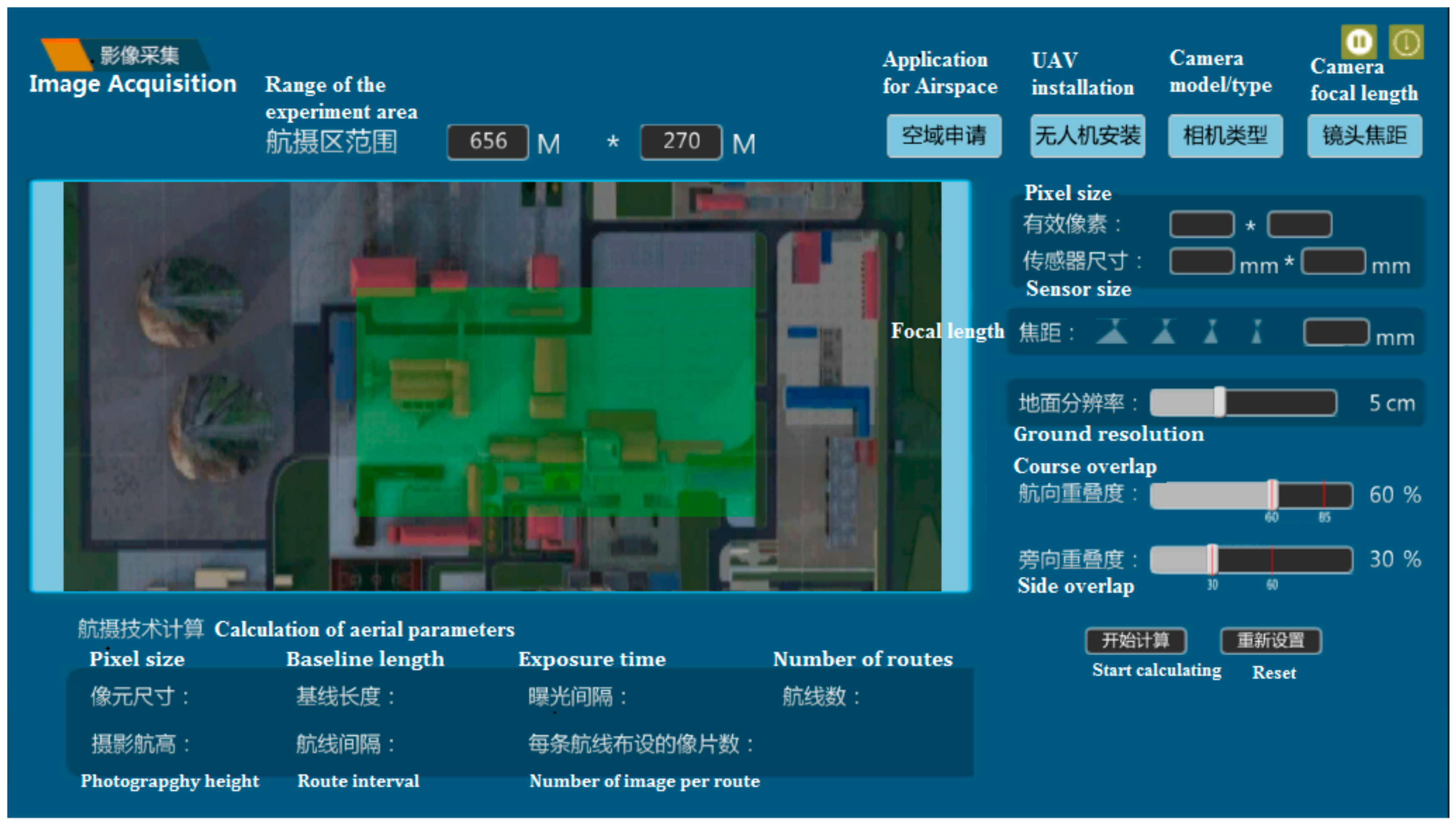
The School of Geodesy and Geomatics was founded in 1956 as the Wuhan Institute of Surveying and Mapping. In this section we define the Virtual Simulation Experimental Teaching Platform of UAV digital mapping platform (VSETP-UAV) using a case study at Wuhan University [25]. The online learning website (Chinese webpage) interface (in Chinese) of VSETP-UAV is displayed in Figure 1.
Figure 1 shows that the VSETP-UAV provides a virtual simulation teaching mode for UAV digital mapping experiment. Through a combination of "virtual data acquisition, virtual reality and cross integration of experimental data", we integrate the teaching of virtual simulation experiments with traditional practical experiments and classroom theory. It contributes to develop students’ comprehensive practice and innovative ability. The objectives of experimental projects are as follows:
(1)
Learn image acquisition and image control point measurement of drone digital mapping;
(2)
Learn the process of image data processing and digital production;
(3)
Teach students’ self-learning and innovative practical ability.
For the teachers, the VSETP-UAV has realistic objectives and uses real-time assessments, while the teacher only gives explicit educational objectives. From the student’s point of view, VSETP-UAV stimulates collaborative and cooperative learning (problems solving). It then allows continuous improvements in their products among others (i.e., team work).

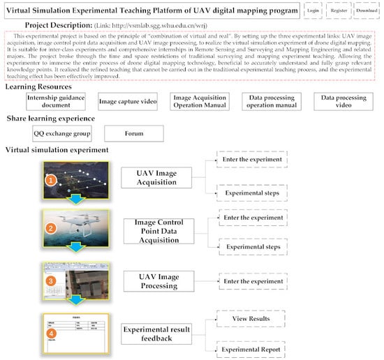
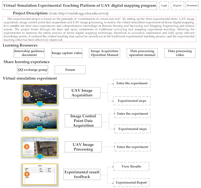
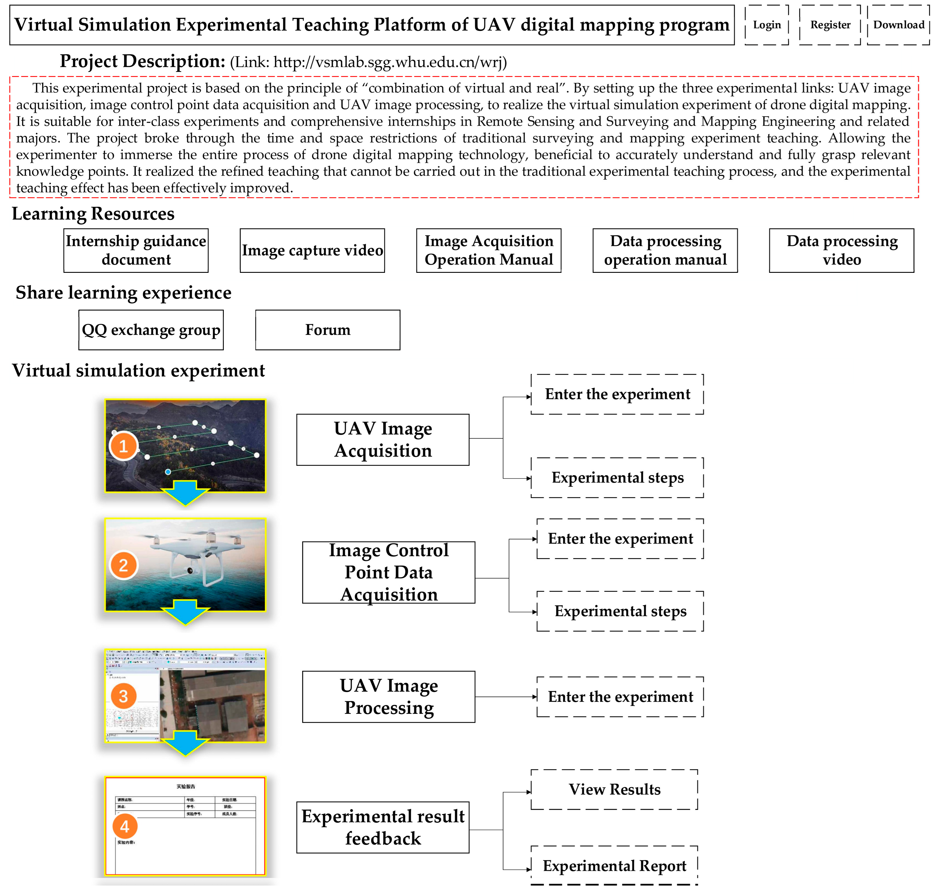
3.2. Systems Design and Function of VSETP-UAV Teaching Platform

In order to facilitate online training skills and according to UAV Photogrammetry workflow and experimental teaching needs, a virtual simulation experiment platform for digital mapping of drones consists of three experimental units using a specific teaching software. The overall architecture of this software is described in Figure 2. Table 2 displays the equipment and software requirements for VSETP-UAV platform. The overall architecture of this software is described in Figure 2. It displays the relationship between various modules (student experiments, teaching) and what is stored in the database. To ensure the operation of the VSETP, VSETP-UAV adopt cloud data computing management technology, relying on high-performance servers and a powerful campus network, and it can meet thousands of concurrent accesses (i.e., for students learning online).
Figure 2 shows that VSETP-UAV breaks the information barrier between different operating systems. VSETP-UAV supports both PC terminal and PAD terminal, and it also supports cross-platform applications. VSETP-UAV platform uniformizes the sharing of data and information by the central server group. The experimental teaching activities are unified through the web portal of the VSTEP-UAV inside and outside the school through teacher and student accounts. Teachers and students need to use their personal accounts and validate it by clicking on the "Login" button to enter the system for teaching management course learning (i.e., the public account for studentss is 15010440119 with password 332211). The two functions, i.e., experiment and management, are taught in separated modules:
a) VSETP-UAV Experimental Module:
This covers the whole process of experimental training (see the Experimental flow chart of VSETP-UAV platform in later Section 3.4). The entire teaching activities are completed through the combination of online experiments and real-time evaluation. The information of the user during the experiments can be recorded into the database in real time through the server. The digital mapping with UAV is one of the main activities for the national topographic maps, especially with the continuous development of RS [26,27]. This platform covers all aspects of the work flow including the ‘data acquisition’, ‘data processing’ and ‘data output’, to enable students to understand and master the knowledge points in each operation step as explained in Table 3 (“n” means the number of knowledge points for the VSETP-UAV platform).
b) VSETP-UAV Management Module:
Firstly, VSETP-UAV provides simulation experiment web interface and information management function for different users, e.g., students want to do experiments via the online platform. Each student or teacher has a separate account. After the user logs in, they are guided by the server to the experimental function module (see step 1, 2, 3 and 4 in Figure 1). Secondly, the VSETP-UAV system records the information of all aspects of the experimental teaching process into the database (MySQL), and uses this database to perform any statistical analysis. Through the database real-time recording functions, all (behavioral) data on the VSETP-UAV platform are stored in the server together with some statistical analysis (e.g., Student learning ability, learning effect and teaching effect analysis). Finally, these statistical analysis results will be fed back to students and teachers to help the adjustment of learning focus and to improve any teaching methods.

3.3. Teaching and Learning Strategies for VSETP-UAV Teaching Platform

As mentioned above VSETP-UAV experiment platform includes: Aerial area selection (place for UAV-digital mapping filed work), UAV Route Planning, UAV instrument installation, Image acquisition and storage, layout of image control points and measurements, Image matching, Aerial Triangulation Digital line drawing (DLG) production, Digital elevation model (DEM) production, Digital orthophoto map (DOM) production [28,29,30].
In order to facilitate the online experiment, the VSETP described in Table 1 is decomposed into four experimental modules. It can be applied to the inter-class experiment of Digital Topography, GNSS Principles and Applications and Digital Photogrammetry for surveying and mapping majors. It can also be applied to the experimental teaching of digital mapping practice, GNSS measurements practice, digital photogrammetry practice and modern surveying and mapping comprehensive practice. The UAV digital mapping virtual simulation platform mainly through the ‘virtual and real combination’, ‘online and offline collaboration’ teaching methods, the realization of the ‘Delicacy Management Experimental teaching’ mode. The specific teaching methods/functions are as follows:
a) Virtual and real combination. Firstly, after the theory of ‘control point data collection’ is taught, the students learn the technical methods and requirements of ‘layout and data acquisition of image control points’ through the corresponding virtual simulation experiment module software. Secondly, the actual experiment is arranged to complete the ‘image control point data acquisition’ of the specified task. In practice, the teacher can use the virtual software to provide the thin soft links (Difficulties and Key Points) in the online practice for the students, and conduct targeted guidance and explanations. Finally, the teachers through the ‘UAV image processing’ virtual simulation experiment module software experimental information real-time evaluation feedback function to complete the inter-class experimental assessment.
Therefore, the "virtual and virtual combination" teaching method has strengthened the "study-practice-test" experimental teaching process based on "experimental teaching quality."
b) Online and offline collaboration: For ‘teaching’ process, classroom theory teaching and experimental demonstration teaching intuitively and reproduce the ‘measurement work scene/field work’ and ‘measurement work flow/office work’ of UAV digital mapping by means of online virtual imitation experiments. It enriches the content and methods of teaching, and improves the teaching efficiency, and it allows teachers to have more time and energy to carry out targeted guidance in the actual experimental teaching.
Furthermore, for students’ “learning”, the online virtual experiment breaks through the limitations of traditional experiments limited by space, time and equipment, enabling students to carry out experimental training independently, and “selecting” their own training content on demand and strengthening it, improving the actual experiment under the line. The operation efficiency has realized the students’ "autonomy" and "individualization" learning, and has exercised the students’ ability of independent study. During the process of "teaching" and "learning", with the aid of social tools such as QQ and WeChat, through the "online and offline collaboration", the interaction between teachers and students is strengthened, and the relationship between teachers and students is also tight.
In summary, the teaching method of "virtual simulation and real data processing operation combination" and "online and offline collaboration", together with the experimental teaching mode of "fine" and "real-time objective experimental evaluation mechanism" have been discussed.

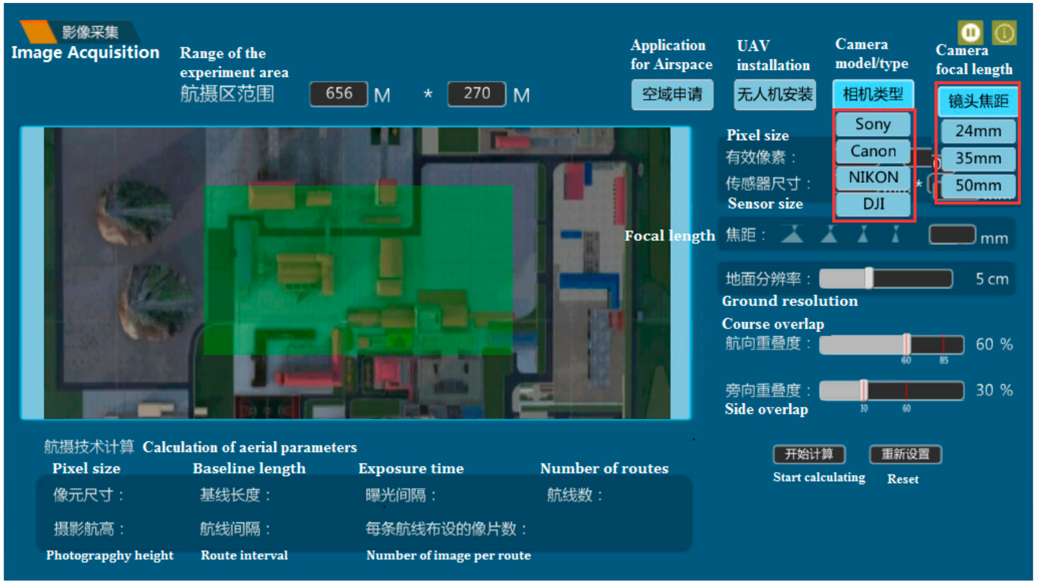
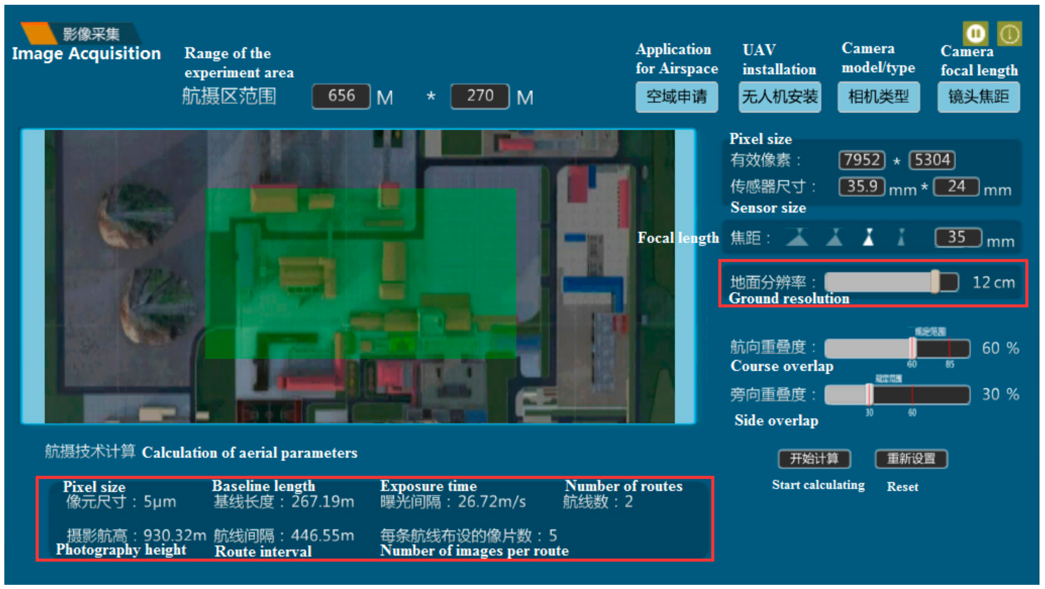
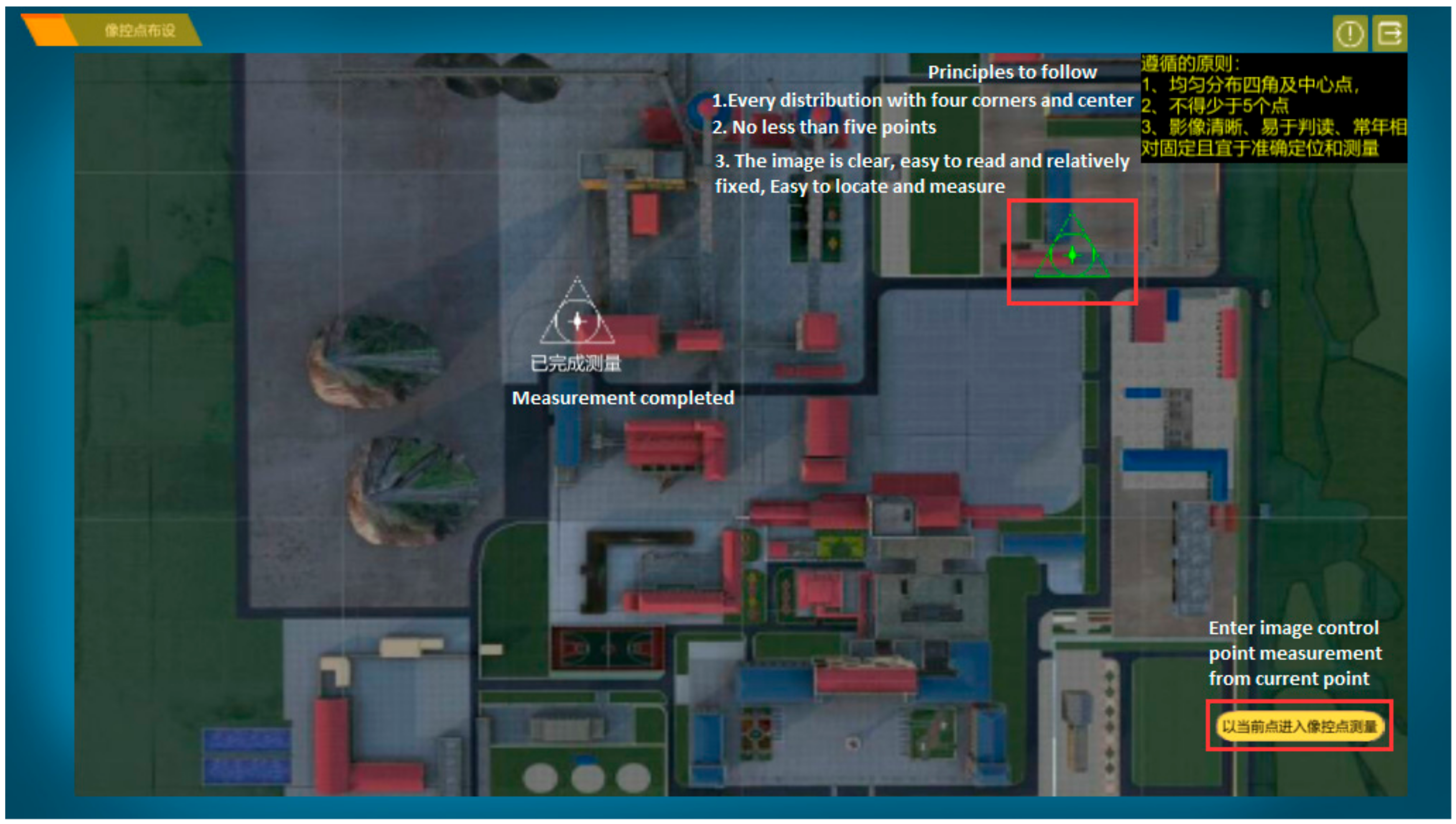
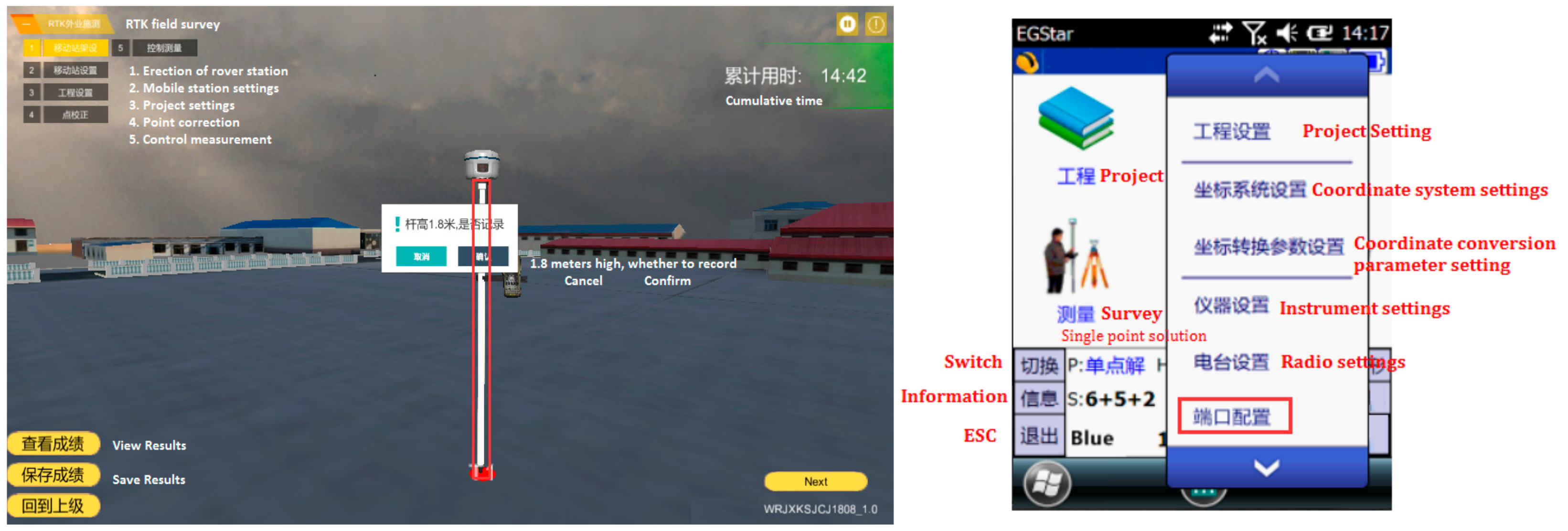
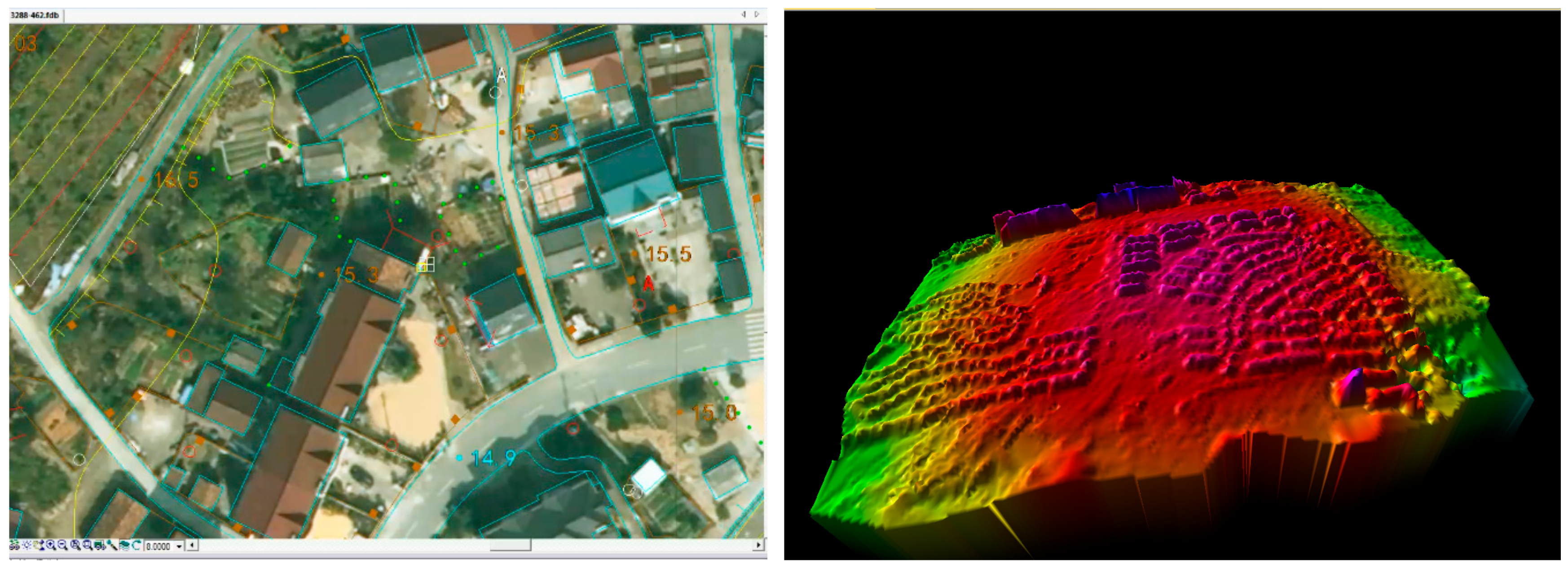
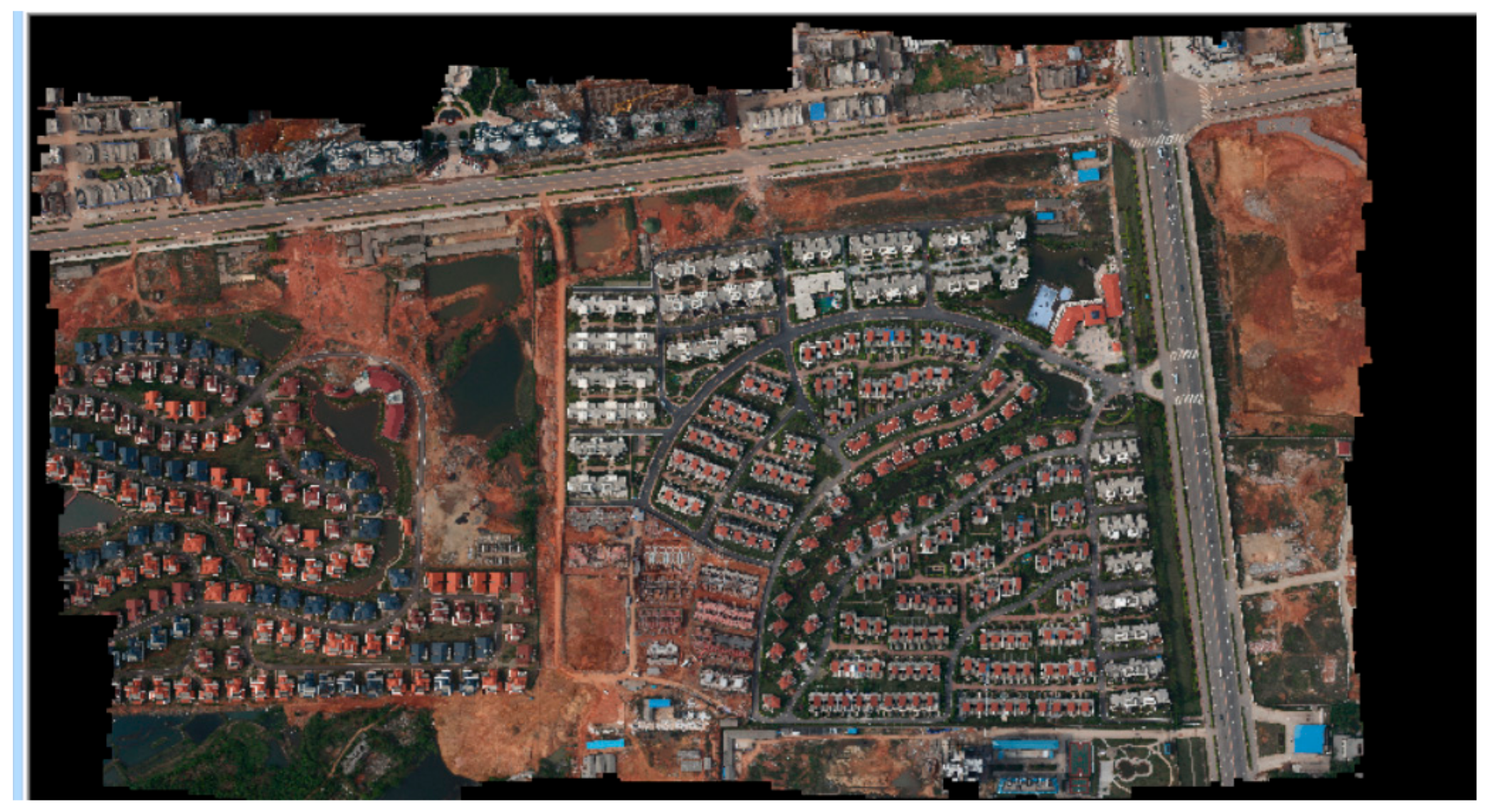
3.4. Experimental Methods and Steps of VSETP-UAV Teaching Platform

According to the workflow displayed in Figure 1 and Table 3, the modules can be sequentially executed according to the actual measurement workflow, and can be independently performed according to the needs of the teacher. The module adopts the experimental method of “Combination of virtual simulation and experimental data” in the comprehensive practice teaching. Based on the virtual simulation experiment to understand the internal operation process, the actual software processes the data and completes the production and display. Moreover, the VSETP-UAV platform can track, automatically record, analyze and evaluate the operational information of the experimental process in real time with the experimental result feedback model.
Before conducting experiments, firstly, students need to get access to the webpage of VSETP-UAV platform according. Students can use the student number and registration password to log in to the experimental platform, and they can conduct experiments according to their own or teachers’ needs.
UAV image acquisition and Image control point data acquisition model can be carried out through the experimental method of "human-computer interaction" way. The students use the mouse to control the VSETP-UAV and perform virtual simulation experiments on the measurement area, to complete UAV course area selection, VSETP-UAV Teaching Platform Airspace Application, UAV installation, Camera Parameter Setting, UAV image acquisition, Image control point measurement experimental content and tasks and the Experimental step flow chart of VSETP-UAV. Student interaction steps are as follows:
Step 1: Selection of experimental area/Location of the “UAV-experimental” and Application for Airspace for UAV experimental. Defining the area on the map according to the existing data, the specific operation mode is as follows: after logging in to the system, select the range of the area with a rectangular frame, then click with the left mouse button (see in Figure 3). Once the experimental area is determined, then the students should know the relevant provisions of the Civil Aviation Administration of China on "Aircraft Management of Unmanned Aerial Vehicles", and submit relevant application materials. For more detail on the user-interface of airspace applications please see the “Experimental steps” of “UAV Image Acquisition” as shown in previous Figure 1 with the online VSETP-UAV platform.
Step 2: UAV air flight preparation, including UAV installation (simulate the installation of the sensor with VSETP-UAV platform), security check and communication link, see Figure 4.
Step 3: UAV Camera Parameter (e.g., camera model, camera focal length) Setting [31], select a different camera model, the image frame will change and you will get different aerial camera technical parameters (see in Figure 5).
Step 4: Aerial photography parameter selection and calculation. According to the defined experimental area and UAV Camera Parameter, calculate the following aerial technical parameters: 1) pixel size (dimension), 2) photography altitude, 3) photography baseline, 4) interval between the airline/route of the UAV surveying, 5) exposure interval, 6) number of routes, 7) number of image layouts on each route (see in Figure 6).
Step 5: UAV image acquisition and Layout of image control point [32]. Observe the status of aircraft, GNSS satellite signals, remote controls, cameras and battery power to meet flight requirements. The image acquisition is started according to the calculated aerial photography technical parameters, the process of capturing the image is displayed, and the acquired image is displayed (and stored), and the acquired image is observed (see in Figure 7).
Step 6: Image control point measurement and analytical aerial triangulation. Coordinate measurements were made on each image control point using GNSS RTK technology [33]. First, set the project name, coordinate system, radio parameters and perform point correction; then, measure the image control points one by one; after all the image control points are measured, export the coordinate results. Image control points measurement mainly include: GNSS reference station, GNSS mobile station settings [34], conversion parameter, point correction (to get the conversion parameters between the WGS84 coordinate system and the local coordinate system) and control survey [35]; the interactive interface is shown in Figure 8.
Then, we implemented analytical aerial triangulation, with matching the image with the same name, using the beam method adjustment, calculate the coordinates of the ground point and the position and attitude of the image, and output the accuracy report.
Step 7: Digital Line Graphic (DLG) and Digital Elevation Model (DEM) are generated. For DLG generate, we orient the image and input the parameters, such as the scale of the map and the coordinates of the map, measure the graph point-by-point, input the attribute code and edit the vector data. In case of the DEM generate, we constructed an irregular triangulation on the ground point of the null three encryption, setting the grid resolution and selecting the sampling method, interpolating to generate digital surface models, then, eliminate buildings and vegetation points on digital surface models to generate DEM. The results of DLG and DEM are shown in Figure 9.
Step 8: Digital Orthophoto Map (DOM) is generated. In this step, students input the DEM, set the resolution of Orthophoto Map and generate DOM. After all the images are orthorected, image stitching lines are generated and all the images are stitched; the results are shown in Figure 10.
Step 9: Result display. Loading the generated DOM and set it as the bottom layer, then loading the DLG or DEM, and set it as the top layer. Finally, the processing results are displayed by superposition of layers DOM and DEM/DLG (see in Figure 11).
Step 10: according to the student’s online experiment operation (step 1~9), the experimental result feedback of VSETP-UAV automatically analyzes a result feedback form.
From the above discussion, the VSETP-UAV platform utilizes technologies such as virtual reality, multimedia, human-computer interaction, database and network communication, with its technical features such as real-time calculation, visualization, simulation and simulation and dynamic interaction, constructed a virtual simulation experiment teaching mode for drone digital mapping of "virtual and virtual integration, virtual reality and cross integration". It realizes the deep integration of virtual simulation experiment teaching and traditional practical experiment teaching and classroom theory teaching, guiding students to learn independently and design independent experiments in the digital environment, and comprehensively cultivate students’ comprehensive practice and innovation ability.
It innovates in terms of time and space restrictions of teaching and learning. The online and offline collaborative teaching methods were constructed to realize the two-way interaction between teaching and learning. It also enriches the choice of students’ learning content and learning style, and strengthens students’ individualization and independent learning.
Finally, through the intelligent management functions such as tracking, statistics and analysis of experimental information in the virtual simulation experiment platform, it is possible to track, count and prompt the experimental information carried out by the students in real time, capture the mastery of each student’s knowledge points and conduct research on the students. The overall situation of the experiment was analyzed globally, and the quality control of refined teaching that could not be carried out in the traditional teaching process of surveying and mapping was realized.
In summary, VSETP-UAV expanded the practical content and training methods of traditional surveying and mapping/Remote sensing course experiments, and created a high-level combination of teaching and research, production and training as a whole. It provides a platform for generating high-quality compound talents with internationally competitive on Emerging engineering education.

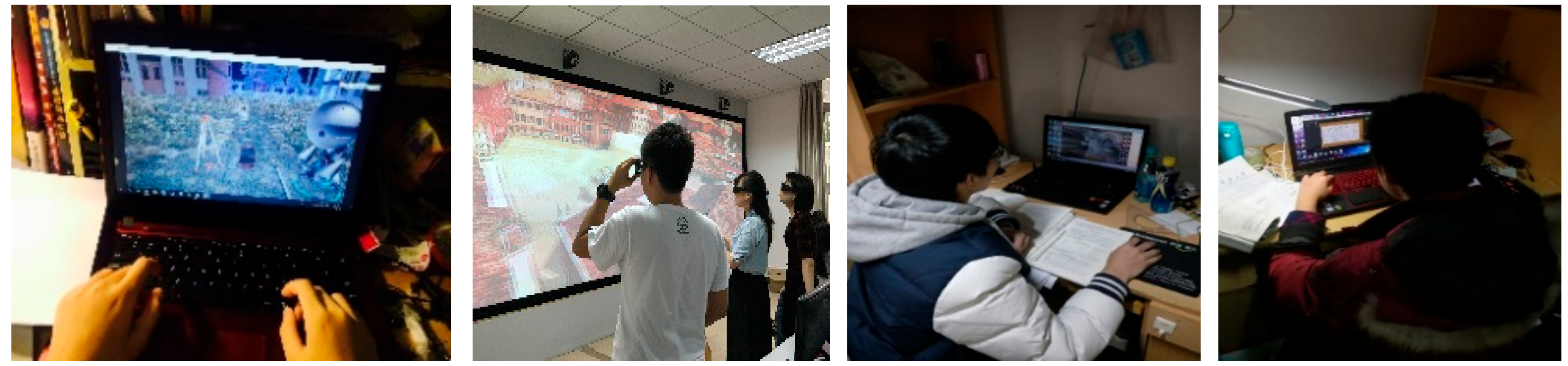
3.5. Results of Implemented VSETP-UAV Teaching Platform

The VSETP-UAV platform has been applied to classroom teaching, student self-learning and communication, assessment and evaluation and skill competition at SGG. At present, this virtual simulation experiment platform has been applied to the fields of “Digital Topography”, “GNSS Principles and Applications” and “Digital Photogrammetry”. Figure 12 shows the inter-class experiment of GNSS, as well as the experimental teaching of "Digital Photogrammetry Internship" and "Modern Surveying and Mapping Comprehensive Internship" course. The number of courses and exams is about 1600, and the number of self-learning students is more than 5600. It is widely used in the “Second Class” students “open independent experiment”, skill competition training and “innovative practice project”.
The main implementation effects are reflected in the following aspects: virtual course teaching effect, student evaluation of the course, Student’s practical ability and innovative ability and social influence.
Firstly, the virtual course teaching effect/results (see Table 4) show that the virtual simulation experiment mode is applied in the experimental course teaching. From both the teacher and the student, the effect and quality of the promotion of experimental teaching are more significant. After the virtual simulation experiment is applied to the experimental course teaching, the effect and quality of the promotion and promotion of experimental teaching are more significant for both the teacher and the student; in particular, the cultivation of students’ practical skills is most evident in the improvement of hands-on ability and meticulousness.
In addition to the improvement in the teaching process, we also achieved good results in the cultivation of students’ innovative practice ability. During the construction of the virtual simulation course, teachers guide the students to do a lot of design, development and testing work, and conducted independent experiments and innovative experiments. Students have achieved many achievements in patents (e.g., Camera shutter delay time measuring device and method- CN105445774A, Display method and device- ZL201510708180.3) and software development (e.g., GNSS simulation experiment teaching system-2016SR056847, Total station virtual simulation measurement system-2016SR075387 and Surveying and Mapping Industry Integration Management System V1.0 based on Android+ASP.NET platform-2018SR420057). These results reflect the cultivation and promotion of students’ innovative practice abilities with the application of the VSETP-UAV platform.
After the virtual simulation, the experiment mode is applied in the experimental course teaching, the effect and quality of improving and promoting the experimental teaching are more significant in both the teacher and the student. Especially for the students’ practical skills training, the most obvious is the hands-on ability and meticulousness, which have greatly improved.
Secondly, after participating in the virtual simulation experiment platform, the overall satisfaction of students in the evaluation of experimental practice teaching methods and curriculum forms is high, and most students think that the curriculum exceeded their expectations. The students pointed out that: 1) the design of VSETP-UAV experiment is comprehensive, detailed process, clear thinking; 2) more vivid, very fun and at the same time exercise personal thinking ability and hands-on ability; 3) combined with the virtual work, we can cultivate surveying thinking and ability very well; 4) the comprehensiveness of the problem of thinking has been exercised.
Thirdly, there is a platform application effect. The VSETP-UAV platform resources are jointly developed by Wuhan University of Surveying and Mapping and social enterprises. During the process of development and application, the participating teachers lead the students to do a lot of design, development and testing work. Students have carried out independent experiments and innovative experiments to effectively serve the cultivation of students’ innovative ability, and achieved many achievements in research and development patents and software development (e.g., related software development, patents, papers).
In addition, the VSETP-UAV platform provides learning resources for undergraduates and graduate students, it helps students to fund self-developed experiments and surveying skills training, helps students participate in the National Surveying and Mapping Skills Competition, science and technology competitions at all levels and gives awards, e.g., in the 5th College Students Surveying and Mapping Skills Competition for China universities, our team won the special prize for the surveying and mapping program design, 1:500 digital mapping, second-class leveling and the group’s first prize. The project “Surveying and Mapping External Service and Management System” won the “Internet +” College Student Innovation and Entrepreneurship Competition Hubei Hubei Bronze Award. More students participate in the National College Students Surveying and Mapping Technology Innovation Paper Competition and achieve better results. It improves students’ practical ability in field data collection and internal data processing, and improves the comprehensive ability of college students to solve production practice problems. Last but not least is the social influence, the talent training platform, course system, syllabus and laboratory construction plan involved in this virtual simulation experiment platform has been promoted and applied in the talent training and teaching of surveying and mapping engineering majors and related majors in colleges and universities nationwide. It has played a leading and demonstrative role in the training of more than 140 colleges and universities in the field of surveying and mapping professionals in CHINA.

4. Discussion

VSETP-UAV teaching platform is based on the principle of “combination of virtual and real experiments”. This was achieved by setting up three experimental links: UAV image acquisition, image control point data acquisition and UAV image processing, in order to realize the virtual simulation experiment of drone digital mapping. It is suitable for inter-class experiments and comprehensive internships in Remote Sensing and Surveying and Mapping Engineering and related majors. The project broke through the time and space restrictions of traditional surveying and mapping experiment teaching. This allows the experimenter to immerse the entire process of drone digital mapping technology, which is beneficial to accurately understand and fully grasp relevant knowledge points. It realized the refined teaching that cannot be carried out in the traditional experimental teaching process; therefore, the experimental teaching effect has been effectively improved.
From Section 3, ‘Virtual Simulation Experiment Teaching Platform for Remote Sensing Higher Education at SGG of Wuhan University’, we showed that the VSETP-UAV platform has played a significant role in modern higher education in RS. VSETP-UAV platform covers the whole process of experimental training. The teaching activities are completed through the combination of online experiments and real-time evaluation. The information of the user in the experiment can be recorded into the database in real-time through the server. Virtual simulation experiment teaching information platform is a new teaching medium, and it combines with informatization experiment environment and internet-based online sharing for modern RS education. Compared to the traditional teaching methods, VSETP-UAV platform are more conducive to promote the continuous improvement of the quality of personnel training, and it has a great value for training "high-quality, internationalization, innovation" surveying and Mapping Engineering professionals.

5. Conclusions

This paper introduced the teaching status of undergraduate education on “Digital Mapping” with Unmanned Aerial Vehicle for Remote Sensing at Wuhan University. Combining the talents of RS, surveying, mapping engineering and modern information technology application, we proposed an innovative virtual simulation teaching platform on Digital Mapping with UAV for RS Education. Firstly, we presented a short analysis on the issues and challenges of undergraduate education on RS. We then evaluated the performance on the Higher Education in Virtual Simulation Experiment Teaching platform of UAV digital mapping for Remote Sensing. We explored the VSETP on unmanned aerial vehicle and analyzed the initial results achieved by the platform. The developed VSETP-UAV platform contributes to the integration of virtual simulation experiment teaching, traditional practical experiment teaching and classroom theory teaching. The online and offline collaborative teaching methods are built to realize the two-way interaction between teaching and learning. It breaks through the time and space restrictions of teaching and learning, enriches the choice of students’ learning content and learning style and strengthens students’ individualized and independent learning. Moreover, it expands the practical content and training methods of traditional RS experiments, generating a high-level combination of teaching, research, production and training altogether. The main implementation effects are reflected in virtual course teaching, student evaluation of the course, gain of students’ practical ability and innovative ability and social influence. It shows that the VSETP-UAV platform contributes to train excellent engineers of high quality, internationalization and innovation in the RS field, in particular to teach students’ practical skills with hands-on ability and meticulousness. Finally, foreign students can only use online translation software, e.g., the use of Internet Explorer to browse VSETP-UAV platform, because the data resources are mainly in Chinese. In the near future, we will improve the platform with an English online learning system. We will also continue to improve the experimental interactive experience in data processing and analysis of results based on project teaching application feedback.

Author Contributions

Project Administration, X.H. (Xianghong Hua); Methodology and Writing-Original Draft Preparation, X.H. (Xiaoxing He), J.-P.M. and K.Y., Conceptualization and Investigation, J.Z.; Visualization and Resources, D.X., H.Z., D.Z. and B.Z.; Writing-Review & Editing, and Z.H.

Funding

This work was sponsored by Research on Teaching Reform in Colleges and Universities in Jiangxi Province in 2019 (Research on Construction of Virtual Simulation Experiment Teaching Information Platform for Surveying and Mapping Engineering Specialty under the Background of High-level Undergraduate Education), National Natural Science Foundation of China (41674005, 41871373, 41904011, 41904027, 4164019, 41904171 and 41730109), Jiangxi Natural Science Foundation of China (20171BAB203032), Jiangsu Dual Creative Teams Program Project awarded in 2017 under Grant CUMT07180005, State Key Laboratory of Rail Transit Engineering Informatization (SKLK19-11), Doctoral Fund of Ministry of Education of China (2018M632909) and Natural Science Foundation of Chongqing (cstc2019jcyj-msxm0701).

Acknowledgments

We would like to acknowledge the anonymous reviewers for their valuable comments and suggestions. The authors thank the support of Experimental Teaching Center of School of Geodesy and Geomatics at Wuhan University for their contribution on the project design and development. We also thank the students who participated in the project.

Conflicts of Interest

The authors declare no conflict of interest.

References

  1. Foresman, T.W.; Cary, T.; Shupin, T.; Eastman, R.; Estes, J.E.; Faust, N.; Jensen, J.R.; Kemp, K.K. Internet teaching foundation for the Remote Sensing Core Curriculum program. ISPRS J. Photogramm. 1997, 52, 294–300. [Google Scholar] [CrossRef]
  2. Warner, T.A.; Foody, G.M.; Nellis, M.D. The SAGE Handbook of Remote Sensing; Sage Publications: Thousand Oaks, CA, USA; West Virginia University: Morgantown, WV, USA, 2009. [Google Scholar]
  3. Xu, C.; Qin, Y. Analyzing the Undergraduate Innovative Talent Training Program of the Surveying and Mapping Engineering. Bull. Surv. Mapp. 2014, 6, 124–127. [Google Scholar]
  4. Campbell, J.; Randolph, B.; Wynne, H. Introduction to Remote Sensing; Guilford Press: Oneonta, NY, USA, 2011. [Google Scholar]
  5. Konecny, G. Geoinformation: Remote Sensing, Photogrammetry and Geographic Information Systems; CRC Press: Boca Raton, FL, USA, 2014. [Google Scholar]
  6. Aina, Y.A.; Aleem, K.F.; Hasan, M.M.; AlGhamdi, H.; Mohamed, A. Geomatics education in the face of global challenges—A Saudi Arabian case study. Surv. Land Inf. Sci. 2014, 73, 81–90. [Google Scholar]
  7. Netzband, M.; Stefanov, W.L.; Redman, C. (Eds.) Applied Remote Sensing for Urban Planning, Governance and Sustainability; Springer Science & Business Media: Berlin, Germany, 2007. [Google Scholar]
  8. Gorelick, N.; Hancher, M.; Dixon, M.; Ilyushchenko, S.; Thau, D.; Moore, R. Google Earth Engine: Planetary-scale geospatial analysis for everyone. Remote Sens. Environ. 2017, 202, 18–27. [Google Scholar] [CrossRef]
  9. Mesas-Carrascosa, F.J.; Pérez Porras, F.; Triviño-Tarradas, P.; Meroño de Larriva, J.E.; García-Ferrer, A. Project-Based Learning Applied to Unmanned Aerial Systems and Remote Sensing. Remote Sens. 2019, 11, 2413. [Google Scholar] [CrossRef] [Green Version]
  10. Thakur, P.K.; Aggarwal, S.P.; Nikam, B.R.; Garg, V.; Chouksey, A.; Dhote, P.R. Training, education, research and capacity building needs and future requirements in applications of geospatial technology for water resources management. Int. Arch. Photogramm. Remote Sens. Spat. Inf. Sci. 2018, XLII-5, 29–36. [Google Scholar] [CrossRef] [Green Version]
  11. Deng, C.; Zhu, J.; Dai, W.; Zou, Z. Exploration on the Training Mode of Advanced Surveying and Mapping Engineering Talents. Mine Surveying. Res. Explor. Lab. 2014, 5, 101–104. [Google Scholar]
  12. He, X.; Lu, T.; Li, C. Exploration on talents training pattern of Surveying and Mapping Engineering under the background of Excellent Engineer Program. Eng. Surv. Mapp. 2018, 1, 77–80. [Google Scholar]
  13. Gan, M.; Hu, P. Intelligence of Higher Education of Surveying and Mapping in the New Subject Stage. Eng. Technol. Res. 2019, 10, 232–233. [Google Scholar]
  14. Coates, H. Student Engagement in Campus-Based and Online Education: University Connections; Routledge: Abingdon, UK, 2006. [Google Scholar]
  15. Nowell, C. The influence of motivational orientation on the satisfaction of university students. Teach. High. Ed. 2017, 22, 855–866. [Google Scholar] [CrossRef]
  16. Zhao, Y.; Zhang, Z.; Zhang, A.; Liu, H.; Sun, Q. Research on Graduation Design Teaching Based on OBE Concept under the Background of Internet plus Geomatics. Bull. Surv. Mapp. 2018, 11, 148–150. [Google Scholar]
  17. Zhang, Y.; Li, C.; Tang, J. Construction and practice of practical teaching system of cultivating applied talents in surveying and mapping engineering major for traffic industry. Eng. Surv. Mapp. 2017, 9, 73–76. [Google Scholar]
  18. Li, Z. UAV for mapping-low altitude photogrammetric survey. Int. Arch. Photogramm. Remote Sens. 2008, 37, 1183–1186. [Google Scholar]
  19. Teunissen, P.J.G. Teunissen PJG 2006 Testing Theory: An Introduction, 2nd ed.; VSSD: Delft, The Netherlands.
  20. Schowengerdt, R.A. Remote Sensing: Models and Methods for Image Processing; Elsevier: Amsterdam, The Netherlands, 2006. [Google Scholar]
  21. Shi, X.; Zhang, Y.; Zhang, L.; Wang, L. Virtual Simulation Experiment Teaching Platform Based on 3R-4A Computer System. In International Conference of Pioneering Computer Scientists, Engineers and Educators; Springer: Singapore, 2016; pp. 110–117. [Google Scholar]
  22. Qu, S.Y.; Hu, T.; Wu, J.L.; Hou, X.M. Experimental Teaching Centre Platform New Engineering Practice Teaching Mode. Eurasia J. Math. Sci. Technol. Educ. 2017, 13, 4271–4279. [Google Scholar] [CrossRef]
  23. Zhang, H.L.; Zhou-Qi, L.I.; Kang, Y.X. Construction of the national virtual simulation experiment teaching center of forest biology. Res. Explor. Lab 2017. [Google Scholar]
  24. Matthew, R.G.S.; Hughes, D.C. Getting at deep learning: A problem-based approach. Eng. Sci. Educ. J. 1994, 3, 234–240. [Google Scholar] [CrossRef]
  25. Xu, C. Preliminary Study of Innovating Courses System of Geodesy and Geomatics. Bull. Surv. Mapp. 2007, 11, 74–77. [Google Scholar]
  26. Alcarria, R.; Bordel, B.; Manso, M.Á.; Iturrioz, T.; Pérez, M. Analyzing UAV-based remote sensing and WSN support for data fusion. In International Conference on Information Theoretic Security; Springer: Cham, Switzerland, 2018; pp. 756–766. [Google Scholar]
  27. Rodriguez, A.L.; Parrilla, L.M.; Simon-Muela, A.; Prats, M.M.; Querejeta, C.; de Blanes, F.G. Real time sensor acquisition platform for experimental UAV research. In Proceedings of the 2009 IEEE/AIAA 28th Digital Avionics Systems Conference, Orlando, FL, USA, 23–29 October 2009. [Google Scholar]
  28. Gupta, R.P. Digital Elevation Model. In Remote Sensing Geology; Springer: Berlin/Heidelberg, Germany, 2018; pp. 101–106. [Google Scholar]
  29. Wu, Z.; Ni, M.; Hu, Z.; Wang, J.; Li, Q.; Wu, G. Mapping invasive plant with UAV-derived 3D mesh model in mountain area-A case study in Shenzhen Coast, China. Int. J. Appl. Earth Obs. Geoinf. 2019, 77, 129–139. [Google Scholar] [CrossRef]
  30. Jalloh, Y.; Ahmad, A.; Amin, Z.M.; Sasaki, K. Conventional Total Station Versus Digital Photogrammetry in Land Development Applications. J. Environ. Anal. Toxicol. 2016, 7, 1–6. [Google Scholar] [CrossRef]
  31. Samad, A.M.; Kamarulzaman, N.; Hamdani, M.A.; Mastor, T.A.; Hashim, K.A. The potential of Unmanned Aerial Vehicle (UAV) for civilian and mapping application. In Proceedings of the 2013 IEEE 3rd International Conference on System Engineering and Technology, Shah Alam, Malaysia, 1–31 July 2013; pp. 313–318. [Google Scholar]
  32. Cramer, M.; Przybilla, H.J.; Zurhorst, A. UAV cameras: Overview and geometric calibration benchmark. Int. Arch. Photogramm. Remote Sens. Spat. Inf. Sci. 2017, 42, 85. [Google Scholar] [CrossRef] [Green Version]
  33. Gerke, M.; Przybilla, H.J. Accuracy analysis of photogrammetric UAV image blocks: Influence of onboard RTK-GNSS and cross flight patterns. In Photogrammetrie-Fernerkundung-Geoinformation; E. Schweizerbart’sche Verlagsbuchhandlung: Stuttgart, Germany, 2016; pp. 17–30. [Google Scholar]
  34. Makadia, A.A.; Dalal, C.S.; Srinivasan, P.K. Automatic Remote Monitoring Stations for GNSS Interference Monitoring. Int. J. Technol. Res. Eng. 2015, 2, 1357–1360. [Google Scholar]
  35. Tonkin, T.; Midgley, N. Ground-control networks for image based surface reconstruction: An investigation of optimum survey designs using UAV derived imagery and structure-from-motion photogrammetry. Remote Sens. 2016, 8, 786. [Google Scholar] [CrossRef] [Green Version]
Figure 1. Description of the Virtual Simulation Experiment Teaching platform for RS education at the SGG-Wuhan University. Where Tencent QQ (also known as QQ), is an instant messaging software service and web portal developed by the Chinese tech giant Tencent
Remotesensing 11 02993 g001
Figure 2. Virtual Simulation Experiment Teaching Platform (VSETP) VSETP-UAV platform structure and functional framework.
Remotesensing 11 02993 g002
Figure 3. Selection of experimental area/Location of VSETP-UAV Teaching Program.
Remotesensing 11 02993 g003
Figure 4. UAV installation, security check, communication link.
Remotesensing 11 02993 g004
Figure 5. VSETP-UAV Camera Parameter Setting.
Remotesensing 11 02993 g005
Figure 6. VSETP-UAV Aerial photography parameter selection and calculation.
Remotesensing 11 02993 g006
Figure 7. VSETP-UAV Layout of image control point.
Remotesensing 11 02993 g007
Figure 8. Image control point measurement.
Remotesensing 11 02993 g008
Figure 9. Digital line drawing (DLG) and Digital elevation model (DEM) generate.
Remotesensing 11 02993 g009
Figure 10. Digital orthophoto map (DOM) generate.
Remotesensing 11 02993 g010
Figure 11. Result display of VSETP-UAV experiment.
Remotesensing 11 02993 g011
Figure 12. VSETP-UAV experiments of grade 2016/2017 undergraduates major in Surveying and Mapping and Earth Science (in and out of class learning).
Remotesensing 11 02993 g012
Table 1. National Virtual Simulation Experimental Teaching Projects of 2018.
OrganizationUndergraduate Teaching Program
Wuhan UniversityUAV digital mapping virtual simulation program
Wuhan UniversityOpen space remote sensing observation virtual simulation experiment teaching project
Capital Normal UniversityUAV aerial photogrammetry virtual simulation comprehensive experimental teaching project
China University of Geosciences, BeijingVirtual Experiment of Spatial Information Collection and Geographic Environment Simulation under Complex Terrain Conditions
Nanjing Tech UniversityVirtual simulation experiment of UAV aerial mapping process
Zhejiang A&F UniversityUAV tilt photography measurement virtual simulation experiment teaching project
Shandong Agriculture and Engineering UniversityRural Revitalization Model Village Digital Mapping Simulation Virtual Experiment Teaching Project
Henan Polytechnic UniversityVirtual Simulation Experiment of Surface Deformation Monitoring in Mining Area
Table 2. Equipment and software requirements for VSETP-UAV platform.
Equipment Requirements
Internet environmentInternet access (>10MB)/Cellular network (4G, 5G)/Campus LAN
CPU (central processing unit)INTEL I5 8400 or higher
Memory4G DDR4 or higher
GPU (graphics processing unit) NVIDIA GeForce>1G
DatabaseMySQL
Monitor1024×768
Operating systemMicrosoft Windows 7 or higher version
Plugin3DS Max, Maya
Development languageJ2EE, JAVA, Unity3D, C#/JS
Development toolEclipse, Visual Studio
Table 3. Knowledge point of UAV digital mapping virtual simulation platform.
nKnowledge PointOperational Steps
1UAV Route Planningdata acquisition
2Aerial photography parameter selection and calculation
3Layout of image control point
4Image control point measurement
5Image matchingdata processing
6Aerial Triangulation
7Digital line drawing (DLG) productiondata output
8Digital elevation model (DEM) production
9Digital orthophoto map (DOM) production
Table 4. Comparison of the effects of virtual simulation experiments on students’ practical skills training.
Experimental ModeOperation Time (Week)Rework RatePractical Assessment Time Skill Performance
PlanActualImage Control Point MeasurementData Processing
Traditional experiment21.7 50%-4 daygood
UAV virtual simulation experiment21.2 20%20–30 min2.5 dayexcellent

