1. Introduction
The dynamics of climate change have significantly increased coastal hazards, presenting challenges to traditional coastal management and resilience strategies [
1]. As global temperatures continue to rise, coastal communities face increased risks from sea level rise, storm surges, and intensified weather events [
2]. Developing successful solutions to protect communities from climate change impacts requires an understanding of the problems the community experiences and community participation in the development of solutions. Nuisance flooding, referring to low levels of inundation, while not posing significant threats to communities, disrupts daily activities, causes property damage, and strains infrastructure systems. Coastal communities are experiencing an increase in nuisance flooding, which requires greater attention for community resilience [
3]. Nuisance flooding may be a result of sea level rise and higher tides, an increase in rainfall intensity, duration, and frequency, or a combination of both. In urban stormwater management, traditional grey infrastructure, which includes gutters, storm sewers, and tunnels, has been a critical component for decades [
4]. These systems are designed to rapidly channel stormwater away from urban areas. However, their effectiveness is being questioned, especially under extreme weather conditions. The expansion of grey infrastructure, while appearing to be an immediate solution, can inadvertently exacerbate environmental issues, such as increased runoff, pollution, and the disruption of natural water cycles [
5]. The implications of nuisance flooding include exposure to pollutants in addition to food insecurity and limited access to medical information and supplies that are critical to emergency management. Areas with limited access and mitigation infrastructure are more likely to have negative outcomes from flood hazards. This study will improve mitigation planning by producing a template with which to structure technical assistance provision for community-centric coastal hazard management. Specifically, it will facilitate interaction between universities, government officials, and citizens to structure mid-term engagement strategies around flood solution design through education and storytelling. The objectives of this study are twofold: to ascertain the role of participatory research in (i) cooperative technical assistance for coastal hazard management through the development of mitigation options, and (ii) the promotion of community-centric mitigation planning processes through educational materials and engagement.
1.1. Grey Infrastructure Solutions
In this context, engineered solutions like seawalls, levees, and advanced drainage systems play a pivotal role in grey infrastructure [
6]. These traditional methods, recognized for their ability to provide immediate flood mitigation, are undergoing significant evolution. Innovations such as deep tunnel systems represent a substantial advancement in grey infrastructure, offering enhanced benefits in flood reduction and water pollution control in urban environments [
7]. Evolving from conventional methods, these systems are increasingly integral to addressing the challenges brought about by the heightened coastal hazards associated with climate change.
However, the reliance on grey infrastructure is accompanied by several limitations. While providing immediate flood defense, these systems often entail high costs and notable environmental impacts [
8,
9]. Their design, largely focused on immediate water diversion through extensive pipe networks and hard surfaces, sometimes lacks the flexibility to adapt to the dynamic nature of climate change, raising concerns about their long-term environmental sustainability. As urban areas continue to grow, the effectiveness of grey infrastructure in managing increased stormwater runoff is being critically examined [
10,
11]. Rapid urbanization further complicates the effectiveness of grey infrastructure [
12]. The pace of urban growth frequently surpasses the development of adequate drainage infrastructure, resulting in a persistent mismatch between urban expansion and infrastructure capacity. While expanding grey infrastructure, such as enlarging the capacity of storm sewers or building more robust flood defenses, might appear to be a straightforward solution, it can inadvertently exacerbate environmental issues, causing unintended consequences.
1.2. Nature-Based Solutions
Nature-based solutions (NbSs) have emerged as a sustainable approach to mitigate coastal risks [
13]. These solutions, also called green infrastructure, include the restoration of mangroves, wetlands, and oyster reefs, and provide the dual benefits of enhancing coastal resilience and offering ecological and societal benefits [
14]. NbSs include green roofs, wetlands, and permeable pavements, offering a more sustainable and ecologically sensitive approach to disaster risk reduction, water security, and climate resilience [
15]. Despite the known benefits for communities when green infrastructure is included in planning, the adoption of NbSs remains slow due to various barriers such as preference for traditional grey infrastructure; cost; political, governance, social, and technological challenges; as well as a general lack of awareness and knowledge about the benefits and efficacy of NbSs [
16]. To overcome this, a shift in mindset towards a holistic and sustainable approach to urban water management is required.
NbSs represent a paradigm shift in engineering, economics, and environmental planning, aiming to maintain or restore hydrological functions while benefiting human and natural systems by working across inter-related natural and built systems, such as transportation and housing, to identify co-benefits [
17,
18,
19,
20]. These solutions, including green roofs and permeable pavements, not only reduce urban flood risks but also improve water quality and availability [
21]. However, misconceptions and the lack of standardized terminologies hinder their broader acceptance [
22]. In practical applications, NbS infrastructures like green roofs and porous pavements integrate with ecosystems, influencing hydrological processes [
23]. Studies show that NbSs can significantly reduce stormwater runoff, easing the burden on drainage systems and reducing maintenance costs [
4,
24,
25]. Further, NbSs can reduce the need for more extensive or costly solutions [
16].
1.3. Balancing Green and Grey Solutions in Planning
The role of neighborhood awareness in flood management approaches is increasingly recognized as a factor in enhancing coastal hazard management [
26,
27]. Effective flood management extends beyond structural solutions and governmental policies; it also centers on the active participation and awareness of local communities. Educated and informed neighborhoods are better equipped to respond to flood warnings, understand the risks, and take appropriate preventative measures [
28]. Community engagement initiatives, such as local workshops, awareness campaigns, and participatory planning processes, play an important role in disseminating knowledge about flood risks and effective response strategies. Such involvement not only promotes a culture of preparedness, but also ensures that local knowledge and experiences are integrated into broader flood management plans.
In urban stormwater management, traditional grey infrastructure, which includes gutters, storm sewers, and tunnels, has been a critical component for decades [
4]. These systems are designed to rapidly channel stormwater away from urban areas. However, their effectiveness is being questioned, especially under extreme weather conditions. The expansion of grey infrastructure, while appearing to be an immediate solution, can inadvertently exacerbate environmental issues, such as increased runoff, pollution, and the disruption of natural water cycles [
5]. To address these challenges effectively, a holistic and sustainable approach to urban water management is essential, with a focus on the importance of community engagement in resilience planning [
29]. This requires both a change in infrastructure choices and a deeper shift in how communities perceive and interact with their environment. To promote beneficial flood mitigation strategies, leading to more inclusive and effective urban flood protection plans, education on the benefits and efficacy of NbSs and the engagement of communities in the decision-making process is needed.
While NbSs are poised to address some of the issues associated with grey solutions, there are known issues with equity related to integrating green solutions into planning, including knowledge building and cross-sector collaboration [
30]. The Connecting Nature Framework is a multi-phase framework including planning, delivery, and stewardship that promotes co-production and calls for the adaptation of these processes to the respective cities engaging in coastal hazard management processes to overcome some of the concerns about equity. A review of existing NbS integration frameworks reinforces this call for methods that are not only spatial or temporal (i.e., focusing on the long term versus the short term), but that focus on the co-creation of knowledge through the acknowledgement of local conditions, as well as prioritization with communities to ascertain the appropriateness of the various solution types as a part of formal planning [
31]. Integration frameworks have been run concurrently with or parallel to traditional planning processes and have been found to complement those that are open to participatory approaches [
32]. By fostering a culture of active participation and awareness, urban communities have become drivers of change, advocating for and implementing NbSs [
29]. This study seeks to adapt these participatory methods to be suitable for local conditions and contexts.
1.4. Community-Centric Engagement
Coastal hazards and sea level rise cause disparate effects for coastal communities. For example, areas prone to frequent hazards have disparate burdens placed upon already overburdened populations because of the prolonged, repeated recovery from recurrent hazards. Nuisance flooding also threatens cities and the low-income populations within them in particular by destabilizing the economy and devaluing properties. Assuming that impacted communities can plan for future hazards based on what they have learned from past experiences only adds to the population’s burden. Resources and solutions must be aligned with the needs and experiences of communities and all the populations within each community to ensure equitable hazard management [
33,
34]. Equitable outcomes require a process to overcome the inequitable distribution of resources, such as mitigation infrastructure and engagement with planning processes [
35,
36]. The United States Federal Emergency Management Agency (FEMA) recommends that emergency managers involve the whole community, particularly faith-based and other local organizations, in planning to strengthen engagement with diverse populations [
37]. Further, Finucane et al. call for more evaluation of means to comprehensively integrate local communities in short- and long-term disaster risk reduction planning and implementation mechanisms, by which local communities can play a major role in determining both short-term and long-term policies [
38]. A community-centric template to guide research and practice efforts that address equity and coastal resilience through adaptive design solution development towards implementation is needed.
1.5. Study Location
Norfolk, Virginia, features some of the highest rates of relative sea level rise (RSLR) on the U.S. Atlantic Coast, which has contributed to increased flood frequency over the past few decades [
39,
40,
41,
42,
43]. For example, nuisance flooding has increased more than three-fold since 1960, and more extreme storm surges have been observed more frequently over the past twenty years [
44]. Climate change is impacting these coastal hazards as well as rainfall intensity, which is expected to increase 30 to 40 percent over the baseline under some climate emission scenarios by 2075 [
45]. Resilience roundtables held in 2019 identified equity as one of the most concerning planning challenges for flood-prone communities and recommended engagement between educational institutions and marginalized communities to improve equity in planning processes and outcomes [
46,
47]. A set of national workshops conducted in 2023 focusing on equitable coastal resilience suggested that tailored mapping, improved process literacy, and awareness raising about green infrastructure was needed to co-produce data with and produce real benefits for communities, particularly where trust and holistic engagement have been limited [
48].
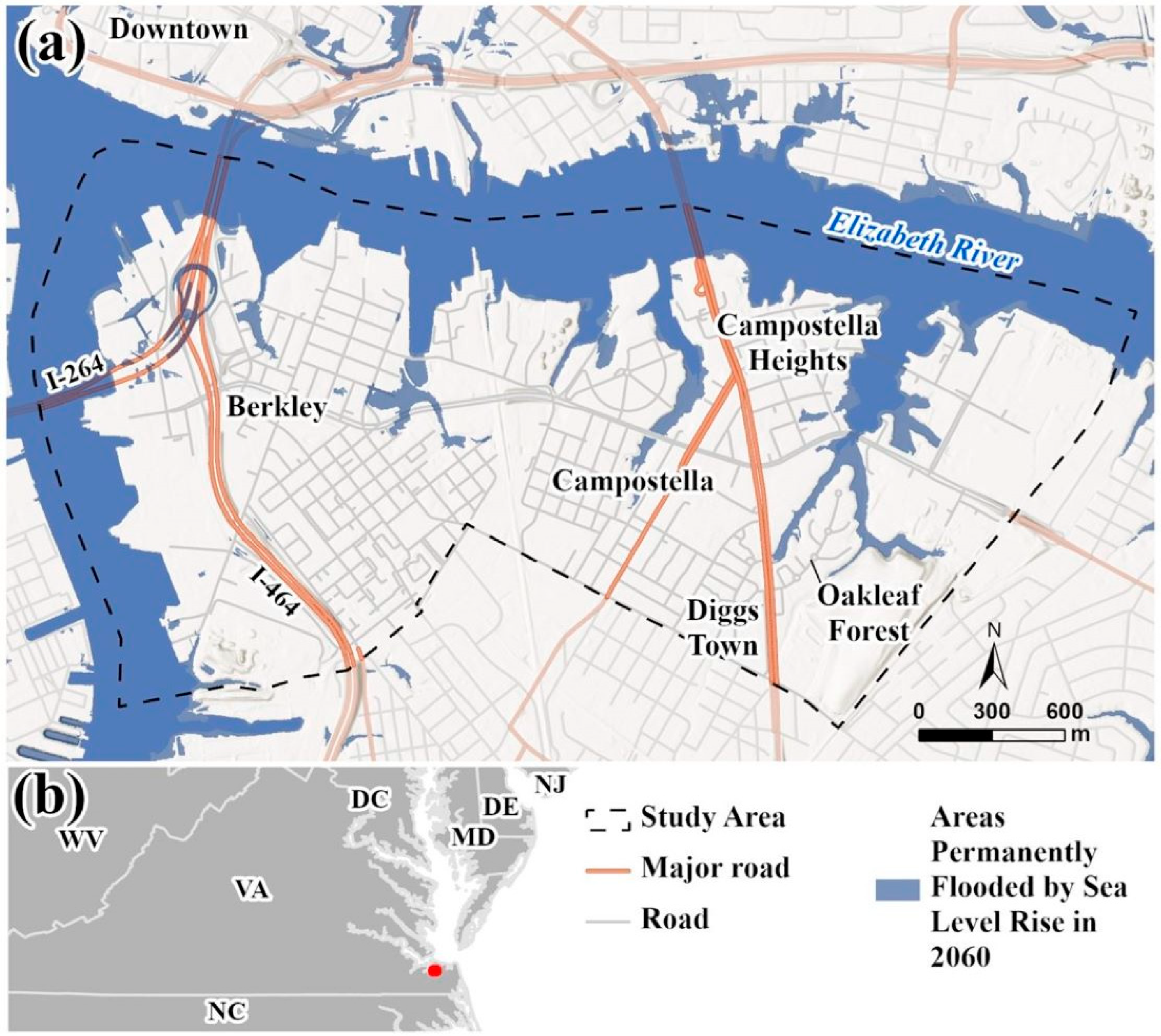
Southside Norfolk is an underserved, environmental justice community consisting of the Berkley, Campostella, Campostella Heights, Oakleaf Forest, and Diggs Town neighborhoods in Norfolk, Virginia (
Figure 1). About one-third of the 7156 residents living in the main zip code for southside Norfolk are high school graduates, 17.1 percent have some high school experience but no diploma, and 18.6 percent have a college degree [
49]. About 9.7 percent of the population aged 25 to 64 years old is unemployed. The United States Army Corp Engineering (USACE) Coastal Storm Risk Management (CSRM) Plans for Norfolk provide the community with wet and dry floodproofing solutions for protection from a major coastal storm [
50]. This leaves the community vulnerable to nuisance flooding related to increased sea level rise, minor coastal storms, and increased rainfall intensity and duration. Conducting an iterative priority setting process for nuisance flooding concurrent with a city-wide flood infrastructural investment allows for community-centric coastal hazard management to be recentered in the planning process, and may set a more equitable means for engagement throughout implementation and emergency management in the event of a major flood event.
2. Methods
The need to refine our approaches for addressing equity in coastal hazard management coincides with communities’ continued struggles with a changing climate. This methodology included educational outreach, participatory mapping, and a survey through presentations at community meetings to bring residents together and tell their stories about flood experiences and prioritize coastal hazard management options throughout their neighborhoods. The potential to reduce inequities was explored by contextualizing the results within local coastal hazard management tools. Based on these results, a template to guide research-informed coastal hazard management solution development was proposed.
2.1. Engagement Process
Old Dominion University (ODU) has a memorandum of understanding (MOU) with the City of Norfolk dating back to before the Institute for Coastal Adaptation and Resilience (ICAR) was established in 2018. Bi-weekly meetings are held to progress the MOU. Further, relationships in southside Norfolk were built for over a year through ODU ICAR’s Commonwealth Center for Recurrent Flooding Resiliency (CCRFR), which supports federal, state, and local government interests, and the Coastal Community Design Collaborative, which unites universities to propose SLR and nuisance flooding solutions at the neighborhood scale through participatory processes. Engagement in southside Norfolk began on 22 December 2022 with a community leaders’ meeting and a bus tour of flood concerns. The engagement strategy was presented and revised based on a follow-up meeting in February 2023 and presented at the Southside Neighborhood Task Force, a coalition of civic league leaders. ICAR is careful not to intrude upon civic league and Task Force meetings without invitation but makes itself available as requested. These engagement efforts were bolstered by a commitment from the Coastal Community Design Collaborative (CCDC), a collaboration between Hampton University Architecture and ODU Civil Engineering and Civil Engineering Technology, to develop flooding solutions over the next two academic years.
Five community engagement meetings followed, with support from the City of Norfolk’s Department of Neighborhood Services, Resilience Office, and the Norfolk Redevelopment and Housing Authority. Engagement meetings were held in each neighborhood between June and October of 2023 that showed educational materials and collected spatial and survey data about the mitigation priorities and educational experience associated with coastal and stormwater flooding. The engagement methodology was adapted based on community input throughout the process. Participants were recruited by the civic league and neighborhood community leaders in advance and by snowball methods on the days of the meetings. Meeting locations and times were also coordinated with civic league presidents and neighborhood community leaders based on convenience for residents, including at an aquatic center, a recreation center, and a computer resource library. Meetings were held over lunch time or in the evenings and lasted approximately 2 h. Additional outreach was provided for the final meeting via a mailer sent to more than 150 addresses identified to be located near flooding locations, as well as 100 randomized addresses in Berkley. The lists were facilitated by City of Norfolk stakeholders and the Norfolk Address Information Resource (AIR). A total of 57 residents attended the community engagement events and 40 completed a post-event survey. Some of the residents who participated in the community engagement event were youths and thus not eligible to complete the survey. One of the limitations of this study is the number of participants. While seventy percent of the participants completed the survey, which is a high percentage of survey completion, the percentage of the population participating was less than 0.008 percent [
49]. This sample reflects a subset of individuals actively involved in their local government that was determined to be suitable in size by the community leaders consulted in the method development.
The research team was posted by the education stations, as well as by the participatory mapping and survey tables to facilitate interactions. No identifying information was associated with the survey or spatial data. Participants were entered into a raffle for a gift card of USD 50 after completing the engagement activities (e.g., education stations, participatory mapping, and survey) as a form of compensation. Meals and coloring books were also provided to acknowledge the time spent engaging with the research and so that participants with children could attend.
2.2. Education Stations
Community engagement meetings aimed to educate community members about the nuances of climate change and flooding solutions through 5 stations (i.e., posters) focusing on the following: (1) climate change, (2) sea level rise and flooding, (3) stormwater flooding solutions, (4) coastal flooding solutions, and (5) flooding in Norfolk. Central to these educational efforts was the goal of building a foundation of trust, a basis of successful community engagement in environmental justice initiatives. Accessible language was used in poster development to accommodate people of all ages and abilities. Detailed explanations of each poster, outlining their specific focus areas and content, are provided in the following section, and the posters are in
Appendix A.
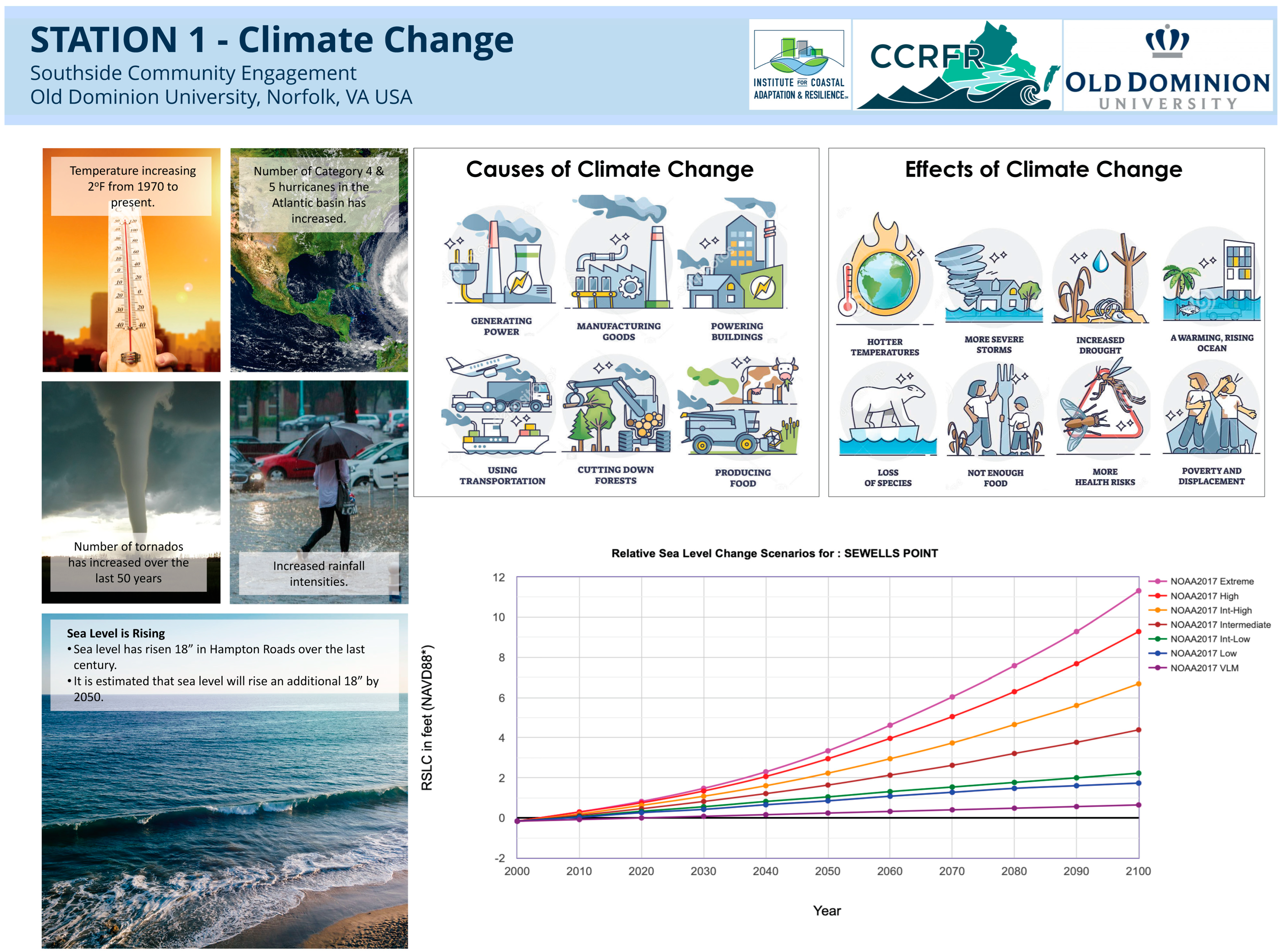
Station 1—Climate Change: At the Climate Change Station, attendees were presented with comprehensive information on the causes and effects of climate change. The station detailed the various aspects of climate change, including the increase in global temperatures, the rising frequency of hurricanes and tornadoes, and the escalation in precipitation levels. Additionally, the poster included NOAA graphs depicting sea level changes over the years.
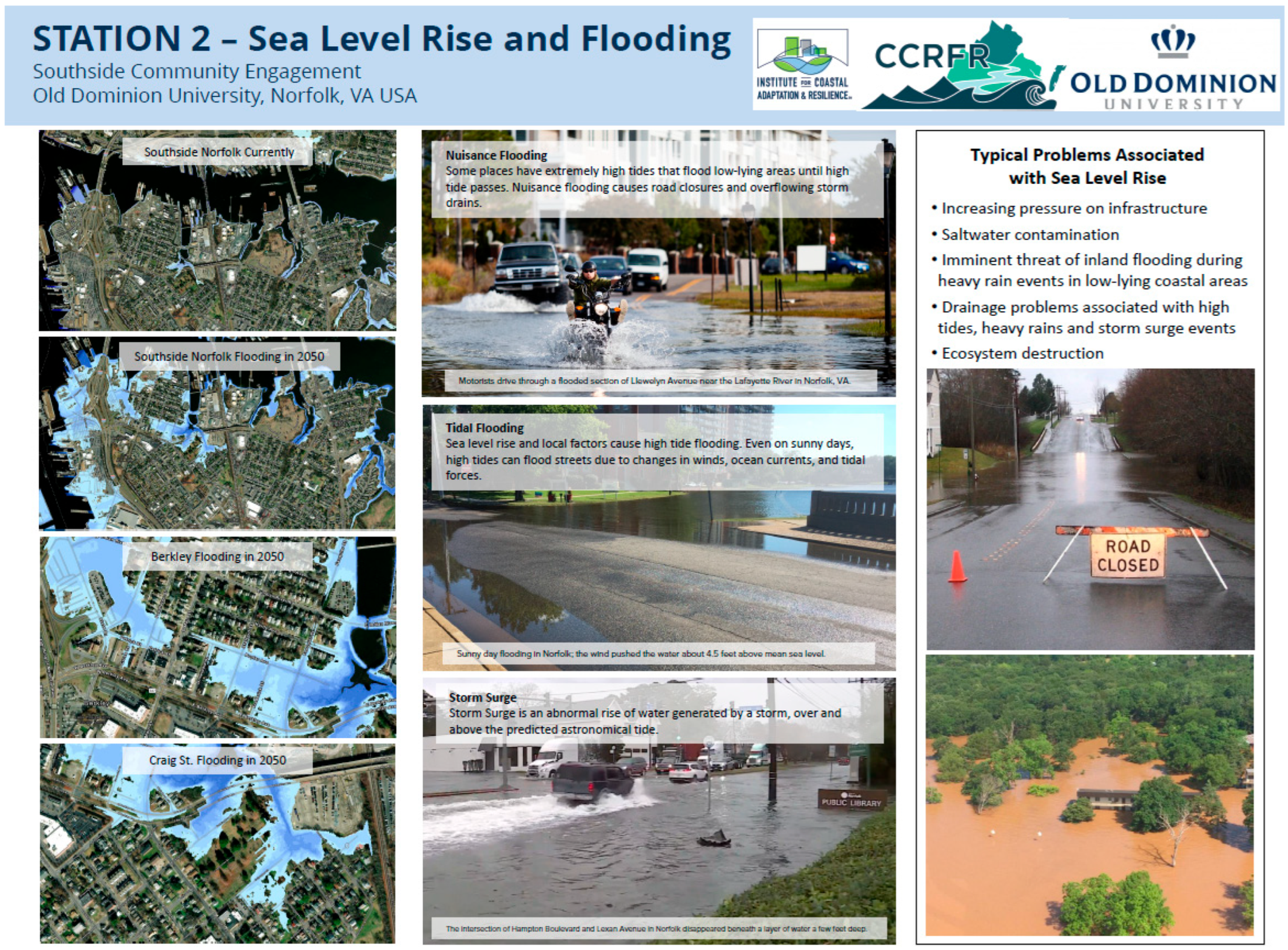
Station 2—Sea Level Rise and Flooding: This station included current maps of southside Norfolk alongside flood projections for 2050 in each community. It also included explanations of terms such as nuisance flooding, tidal flooding, and storm surge. The station highlighted typical problems associated with sea level rise, supplemented with images to provide a clearer understanding of these issues.
Station 3—Stormwater Flood Solutions: At this station, the focus was on green infrastructure and its benefits, including a comparison between green and grey infrastructure. This station illustrated various green infrastructure solutions like rainwater harvesting, permeable pavements, rain gardens, and stormwater planters, explaining how each contributes to effective stormwater management.
Station 4—Coastal Flood Solutions: This station explored both structural and non-structural approaches to mitigate coastal flooding. It covered structural solutions such as seawalls, bulkheads, revetments, breakwaters, sills, groins, and house elevation techniques. Additionally, it presented non-structural solutions like living shorelines, marsh fringes, and oyster reefs, illustrating the available options for nuisance flood mitigation.
Station 5—Flooding In Norfolk: The last station presented a real-world perspective by displaying actual images of flooding events on various roads and in communities within southside Norfolk. These visuals provided attendees with a solid understanding of the flooding impacts in their own neighborhoods.
2.3. Web App Development
Using the Hampton Roads Regional Parcels dataset from the Hampton Roads Geospatial Exchange Online (HRGEO) open data portal, tax parcels for the cities of Norfolk and Portsmouth in southeast Virginia were analyzed and categorized based on their ownership status. Publicly owned parcels were broken down into seven categories: Owned By Locality, Public Schools K-12, Public Parks, Higher Education (Public/Private), State/Regional/Federal, Cemeteries, and Utility. Once categorized, parcels for Norfolk and Portsmouth were published to Esri’s ArcGIS Online, and an Experience Builder web application was created. The study area of the southside Norfolk neighborhood was identified by CCRFR and two public-facing layers, called assets and challenges, were created to gather public feedback on flooding and infrastructure in the community. Supplemental layers were added to the web application to aid the public in crafting their feedback. These layers consisted of the following: Coastal Virginia Sea Level Rise and Minor-to-Moderate Flooding projections, developed by Old Dominion University’s Center for Geospatial Science, Education & Analytics, for the year 2060, Hospitals, Public Libraries, Watersheds, USA Flood Hazard Areas, FEMA Flood Hazard Areas, Heat Severity in the USA for 2021, U.S. Urban Heat Island Mapping Campaign for Norfolk, and a World Terrain layer.
Participants were encouraged by the research team to add as many data points as they wanted through the web app or on a printed map. The following directions were provided: Explore the map and tell us about assets and challenges in southside Norfolk. Pan the map, zoom in, and zoom out to locate places on the map where you believe assets and/or challenges are present. Click on either the assets or challenges button under the Create Features column to the left to add a point to the map. What category is the asset? Select from Community, Food/Shopping, Health/Safety, Public Services, Roads/Bus Routes, Housing, or Other. What category is the challenge? Select from Pollution, Safety, Roads/Bus Routes, Flooding, Heat, or Other. Once you have placed a point on the map, select an asset or challenge type from the drop-down list and then provide a description. Use the panel on the right to toggle map layers on and off. The spatial data collected 119 challenge points where flooding is a problem and 24 assets in need of protection from flooding; of these, 12 challenges and 8 assets were excluded from analysis because they were outside the study area. The results were analyzed using basic statistical methods, and select quotes were included to add context to the analysis.
2.4. Education and Flood Solutions Survey
The survey asked (i) how much, if at all, the first four education stations addressing climate change, sea level rise, stormwater solutions, and coastal flooding solutions increased knowledge of coastal and stormwater flooding solutions, and (ii) which flood solutions (i.e., downspout disconnection, rainwater harvesting, permeable pavements, below-grade stormwater collection, rain gardens, bioretention basins, stormwater planters, seawalls, bulkheads, revetments, breakwaters, sills, groins, jetties, living shorelines, marsh fringes, or oyster reefs) were of interest for the community. Taking the survey indicated participation in all stations and the participatory mapping portions of a given meeting, except for Station 5, which was not included in the survey as it was added after the initial community engagement meetings based on verbal requests made to the research team by participants to see more examples of flooding from their neighborhoods. Forty responses were recorded. The results were analyzed using basic statistical methods, and select quotes were included to add context to the analysis.
3. Results
A critical component of the engagement includes understanding what assets are valued by the community, where flooding is disrupting the community, and the community’s flood solution preferences. This study used an iterative participatory research process to co-produce a template for community-centric mitigation planning. First, the spatial and survey data collected in engagement meetings are analyzed. Then, the process that generated these results is discussed in light of local coastal engagement best practices.
3.1. Using Participatory Mapping to Set Management Priorities
Figure 2 shows the asset and challenge points generated by participants. Although some points outside the study area were identified and are relevant to residents’ experiences, they were removed from the analysis because the scope of the CCDC project is only within the five neighborhoods.
Participants recorded 16 total assets within the study area including: Roads/Bus Routes (5), Public Services (4), Housing (3), Other (3), and Community (1). Roads were the most noted assets, followed by public services and housing. Assets noted for their role in flooding included a drainpipe at the pier and a vacant lot that was perceived to store water. It was also noted that the fire station is important during flooding and a distribution center was built at an elevation that allows it to maintain operations during a flood. Other noted assets included churches, a local radio station, the aquatic center, the early childhood education center, the hospital, and a fishing location. The full set of attributes for each point noted by participants appears in an ArcGIS web map (
Supplementary Materials).
Participants recorded 107 challenges within the study area including: Flooding (105), and Other (2). The two ‘Other’ challenges were noted as needing natural barriers to reduce flooding either instead of a rock barrier or in the absence of any protection. Challenges were described as whole streets flooding, intersections flooding, houses flooding, and yards flooding. The most frequently stated challenge was ‘entire’ streets flooding, which was mentioned 21 times. Specific intersections, blocks, buildings, and Pescara Creek were identified as priority areas for flood solutions. Challenges were associated with heavy precipitation, water accumulation, tidal flooding, sea level rise, ineffective downspouts, new construction, hilly landscapes, fill, storm surge, rip rap, a creek, lack of drains, sump pump backup, lack of natural infrastructure to absorb water, a drainage pipe at the pier, and low elevation. Heavy rainfall was noted 39 times, tides 2 times, and drainage 6 times. Effects were noted not just for roadways and housing, but also for a trucking company. Challenges make roads impassable, flood homes and cars, prevent access to churches, flood the fire station, and cause difficulty securing insurance.
3.2. Station Ratings and Interest in Solutions
The majority of residents indicated that all four stations increased their knowledge “a great deal” (see
Figure 3), with 72.5% of residents indicating that Station 2 (sea level rise and flooding) increased their knowledge a great deal. About two-thirds felt that Stations 3 (65%) and 4 (67.5%) (storm flooding solutions and coastal flooding solutions) increased their knowledge a great deal, as did 60% for Station 1 (climate change).
Regarding storm water flooding solutions (see
Figure 4), half or more of the residents were interested in rain gardens or permeable pavements as possible solutions in their community. More than 40% expressed interest in stormwater planters and rainwater harvesting.
Regarding coastal flooding solutions (see
Figure 5), more than half of the participating residents (52.5%) were interested in seawalls. Residents were also interested in bulkheads (32.5%), breakwaters (27.5%), marsh fringes (25%), and revetments (25%). There was less interest in groins, sills, and jetties. For nuisance flooding solutions, 45% were interested in oyster reefs and 42.5% were interested in living shorelines for their community.
Overall, comments from residents indicated that they found the community engagement events informative. One person wrote “This is great for community having input and solutions”, and another shared “This presentation has helped me view my community differently”. Additionally, a few community members raised concerns about pollution in the area. One person wrote, “Plastics from the storm (high tide/debris trash and pollution) go into the river. Interested in the river clean-up”. A few community members mentioned the idea of having elevated houses or wanting the city to provide rain barrels. Lastly, one community member mentioned how the neighborhoods need redesigning for street storm drains.
3.3. Towards a Template for Community-Centric Technical Assistance Provision
The Ohio Creek Watershed Project in Norfolk’s Chesterfield Heights neighborhood, which is adjacent to southside Norfolk across the Elizabeth River, serves as a national example for community-centric coastal hazard management [
51]. The CCDC’s adaptive design concepts were developed with Chesterfield Heights community involvement and focused on adaptation before significant storm and flooding damage occurred. The Ohio Creek Watershed Project was incorporated into a grant application by the City of Norfolk and submitted to the Department of Housing and Urban Development’s (HUD) National Disaster Resilience Challenge. This led to an award of USD 112 M for the City of Norfolk to be used in the execution of flood prevention measures for the Ohio Creek Watershed/Chesterfield Heights neighborhood. The design addresses flood risk as well as economic opportunity by improving social and environmental connectivity by complementing existing infrastructure with nature-based solutions, such as living shorelines and parks that serve a dual purpose of stormwater retention with actively managed pumps, gates, and valves. This process has been used in other urban areas throughout the Commonwealth of Virginia [
52].
The CCDC methodology used in Chesterfield Heights is supported in the five environmental justice neighborhoods comprising southside Norfolk, through the community engagement described in this study. The spatial and survey data gathered in the community engagement process will be used to ensure community flooding from pluvial and tidal sources and particular challenges from specific features, such as creeks and drainpipes, are addressed, and assets including clearly identified intersections and houses are protected. The continuation of work in southside Norfolk through December 2025 is sponsored by a USD 700,000 grant from the National Fish and Wildlife Foundation, leveraged by ODU with Hampton University and Wetlands Watch in January 2024 [
53].
The early 2000’s saw governance models shift to have project stakeholders as equal partners who inform planning processes through their experiences and expertise [
54]. Frequent and genuine communication between involved and affected parties, and measurable success at intervals including short term, mid-term and long term, underpin equitable processes [
55]. An effective process that is more focused on holistic resilience rather than hazard management that was also honed in coastal Virginia is the Resilience Adaptation Feasibility Tool (RAFT). RAFT also features long-term engagement and priority setting supplemented and implemented with educational resources and connections between universities and local government [
56]. Further, participatory mapping, a key part of the CCDC process implemented in southside Norfolk, is known to be able to address inter-related systems, such as housing and transportation, and has been utilized at the neighborhood scale in Virginia to both effectively capture institutional knowledge and facilitate the alignment of SLR-specific management priorities with the Pamunkey Indian Tribe when paired with a resilience matrix and improve food security data in the Hampton Roads cities of Norfolk, Portsmouth, and Chesapeake [
57,
58]. Pairing participatory mapping with educational materials and an evaluation method extends the awareness-raising and iterative capacities of such tools, which improves the engagement between universities, government, and community by connecting officials and universities with the priorities developed by the community from the onset instead of leaving the community with a list of priorities to resource themselves.
Visualizations of flooding, especially, have been shown to elicit Hampton Road residents’ interest in and willingness to improve residential solutions [
59]. Providing educational materials with visualizations allows residents to avoid the common pitfall of limiting their solution preferences to the same ones chosen by their neighbors, and maintaining the dialogue with officials addresses residents’ calls for cities to invest in flood solutions and train residents in monitoring, as identified in multiple visualization studies [
48,
50]. This study of the mid-term CCDC process offers a template to guide university engagement in research-to-practice efforts. These efforts align with government and community partner priorities for community-centric coastal hazard management. Specifically, they involve long-term engagement and storytelling informed by educational materials and participatory mapping, which are evaluated by surveying. The template offers a process with which to align other proven planning tools, such as scorecards and matrices with resources through intentional information sharing and evaluation. Such an iterative process was used to refine the RAFT for tribal nations for short-term tribe-centric planning through iterative consultation with tribal councils and citizens to adapt a resilience scorecard and action checklist. This has since been extended to mid-term through the CCDC [
60]. Further, this template sets the stage for triangulating expressed priorities with spatial data on community assets and challenges that empowers communities to understand and interact with implementation and monitoring through ongoing education, engagement, and evaluation to keep coastal hazard management community-centric into the long term.
4. Conclusions and Recommendations
This study explores results generated from participatory approaches to ascertain their contribution to coastal hazard management priority setting and educational engagement processes. With these findings, a template for technical assistance provision for community-centric coastal hazard management is generated.
Residents expressed a strong preference for green infrastructure solutions, including rain gardens, permeable pavements, and living shorelines, alongside concerns about pollution and the need for infrastructure redesign. Roads, housing, and public services are the top asset-preservation priorities. The most prevalent challenges were entire streets flooding, and the most perceived source of flooding was precipitation. Preferred solutions should be triangulated with assets and challenges, and educational materials should be produced and distributed to communities for the most aligned and empowering solution development, distribution, and monitoring.
The majority of residents reported that the education stations increased knowledge “a great deal”. Based on the survey, a set of interactive educational materials should be developed to address the remaining potential for educational exchanges between universities and communities to complement the adaptive solutions being designed by CCDC with information on (i) sea level rise, (ii) storm flooding solutions, (iii) coastal flooding, and (iv) climate change and how the solutions developed will protect prioritized assets and address prioritized challenges.
A template for mid-term participatory research to inform coastal hazard management includes the following: (i) regular, long-term engagement between universities, local government, community leaders, and residents, and (ii) education, surveying, and participatory mapping to inform and tell the story of the community to decision makers and researchers that can align solutions and funding with lived, local experiences. Building trust was a challenging key aspect of the project, engrained through community-informed engagement (e.g., civic leagues and Task Force invitation, and Office of Resilience bi-weekly), local government officials (e.g., City of Norfolk Office of Resilience attendance with ODU at Task Force meetings, civic leagues, and project methods defining meetings) supporting outreach, and long-term commitment by universities to sourcing implementation and funding opportunities for the community with the local government (e.g., City Office of Resilience). Non-profit and academic organizations that plan to work in environmental justice communities, as well as localities that are interested in developing collaborative relationships with entities that can be neutral trust-building agents in a community, will benefit from work that leads to community-centered coastal hazard planning and implementation that is equitable and inclusive by being representative of and responsive to community educational needs and management priorities. Cities should seek to pilot and evaluate the CCDC process and, then, transfer and adapt it as more neighborhoods identify themselves as interested.

 ,
, 


