
Satellite Assessments of Tropopause Dry Intrusions Correlated to Mid-Latitude Storms


Abstract
:1. Introduction
2. Methods
2.1. Upper-Tropospheric Moisture Retrieval
2.2. Segmentation
2.3. Optimized Adjustments
3. Results
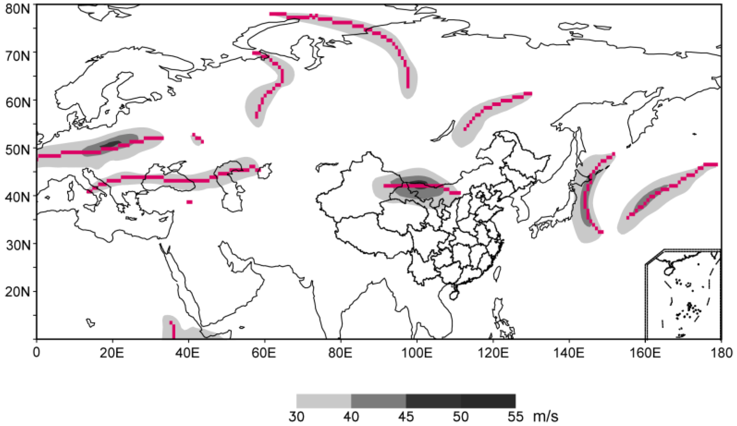
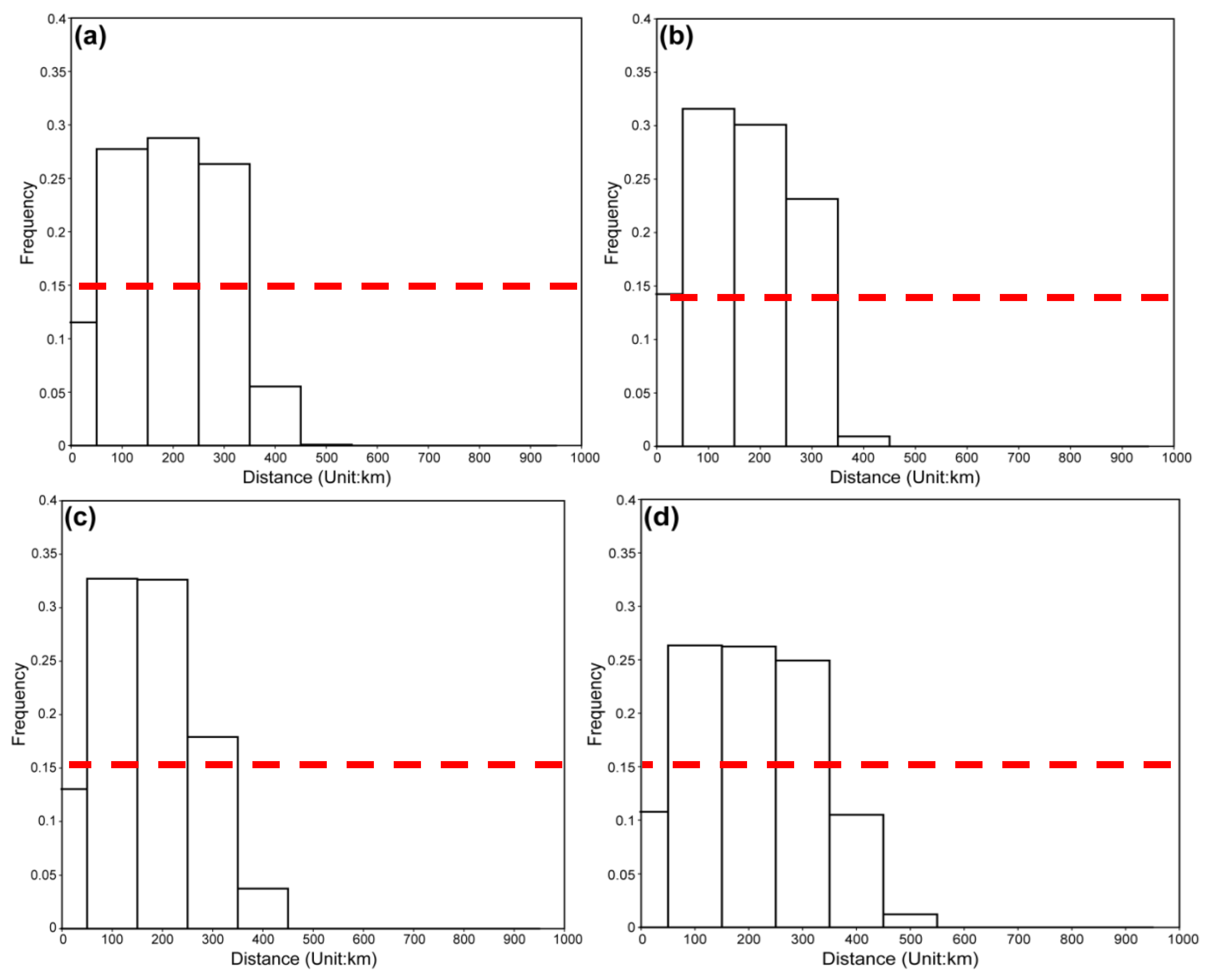
3.1. Validation
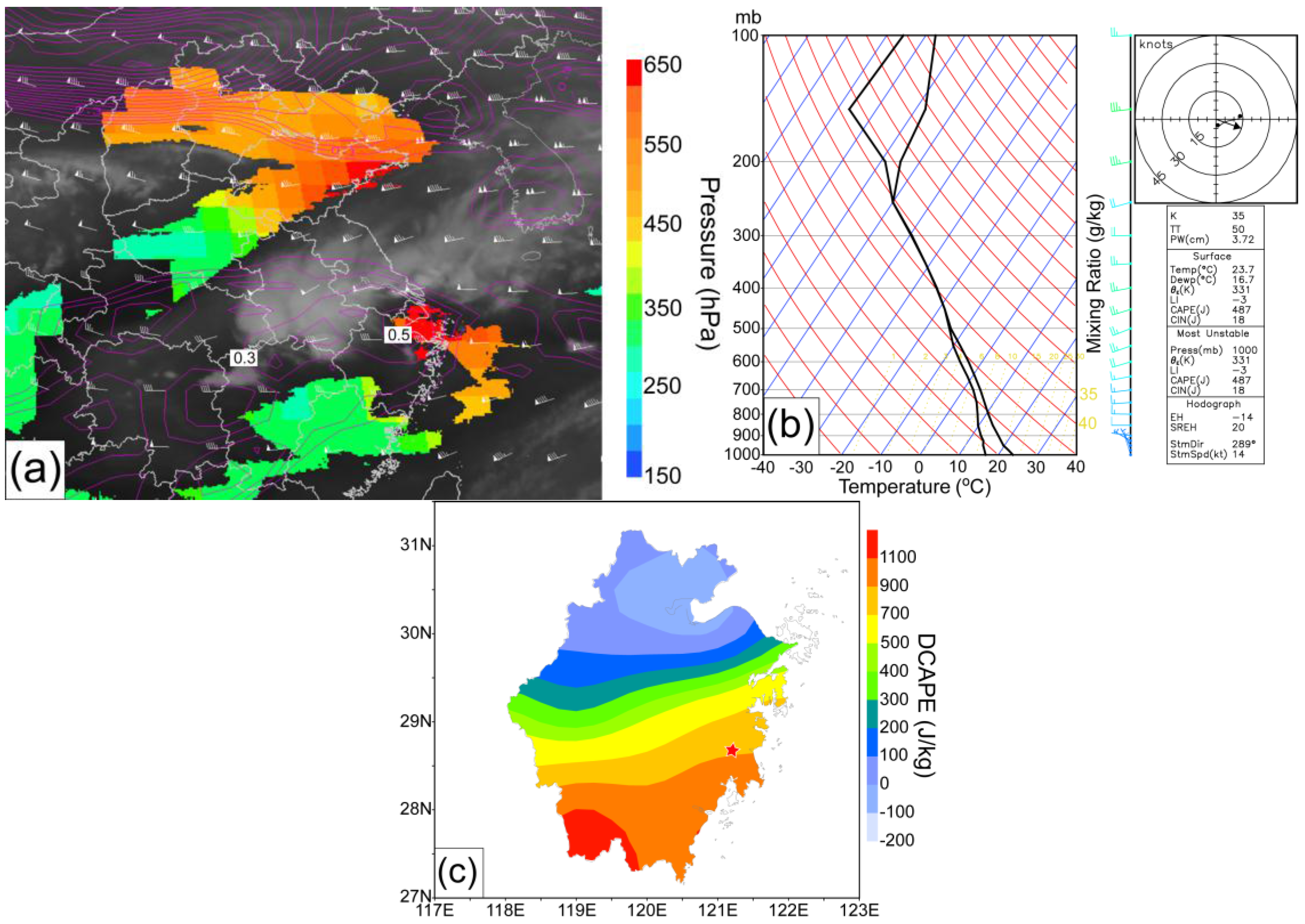
3.2. Case I: A Rainstorm Event
3.3. Case II: Hailstorm Event
4. Conclusions
Acknowledgments
Author Contributions
Conflicts of Interest
References
- Shou, S.; Li, S.; Yao, X. Mesoscale Meteorology; Meteorological Press: Beijing, China, 2003. (In Chinese) [Google Scholar]
- Reid, H.J.; Vaughan, G. Convective mixing in a tropopause fold. Q. J. R. Meteorol. Soc. 2004, 130, 1195–1212. [Google Scholar] [CrossRef]
- Nastrom, G.D.; Green, J.L.; Gage, K.S.; Peterson, M.R. Tropopause folding and the variability of the tropopause height as seen by the flatland VHF radar. J. Appl. Meteorol. 1989, 28, 1271–1281. [Google Scholar] [CrossRef]
- Bertin, F.; Campistron, B.; Caccia, J.L.; Wilson, R. Mixing processes in a tropopause folding observed by a network of ST radar and Lidar. Ann. Geophys. 2001, 19, 953–963. [Google Scholar] [CrossRef]
- Roger, B.W.; Holmes, S.J. Water vapor imagery: Interpretation and applications to weather analysis and forecasting. NOAA Tech. Rpt. NESDIS 1991, 57, 213. [Google Scholar]
- Lamarque, J.F.; Hess, P.G. Cross-tropopause mass exchange and potential vorticity budget in a simulated tropopause folding. J. Atmos. Sci. 1994, 51, 2246–2269. [Google Scholar] [CrossRef]
- Bithell, M.; Gray, L.J.; Cox, B.D. A three-dimensional view of the evolution of midlatitudes stratospheric intrusions. J. Atmos. Sci. 1999, 56, 673–688. [Google Scholar] [CrossRef]
- Appenzeller, C.; Davies, H.C. Structure of stratospheric intrusions into the troposphere. Nature 1992, 358, 570–572. [Google Scholar] [CrossRef]
- Wimmers, A.J.; Moody, J.L.; Browell, E.V.; Hair, J.W.; Grant, W.B.; Butler, C.F.; Fenn, M.A.; Schmidt, C.C.; Li, J.; Ridley, B.A. Signatures of tropopause folding in satellite imagery. J. Geophys. Res. 2003, 8360. [Google Scholar] [CrossRef]
- Moody, J.L. Tropopause folding at satellite-observed spatial gradients: 1. Verification of an emipirical relationship. J. Geophys. Res. 2004, 109. [Google Scholar] [CrossRef]
- Moody, J.L. Tropopause folding at satellite-observed spatial gradients: 2. Development of an empirical model. J. Geophys. Res. 2004, 109. [Google Scholar] [CrossRef]
- Michel, Y.; Bouttier, F. Automated tracking of dry intrusions on satellite water vapour imagery and model output. Q. J. R. Meteorol. Soc. 2006, 132, 2257–2276. [Google Scholar] [CrossRef]
- Michel, Y. Data assimulation of tropopause height using dry intrusion observations. Mon. Weather Rev. 2010, 138, 101–122. [Google Scholar] [CrossRef]
- Soden, B.J.; Bretherton, F.P. Interpretation of TOVS water vapor radiances in terms of layer-average relative humidities: Method and climatology for the upper, middle, and lower troposphere. J. Geophys. Res. 1996, 101, 9333–9343. [Google Scholar] [CrossRef]
- Soden, B.J.; Bretherton, F.P. Upper tropospheric relative humidity from the GOES 6.7 μm channel: Method and climatology for July 1987. J. Geophys. Res. 1993, 98, 16669–16688. [Google Scholar] [CrossRef]
- Moody, J.L.; Wimmers, A.J.; Devenport, J.C. Remotely sensed specific humidity: Development of a derived product from the GOES Imager Channel 3. Geophys. Res. Lett. 1999, 26, 59–62. [Google Scholar] [CrossRef]
- Gao, S.; Zhou, F.F. Water vapour potential vorticity and its applications in Tropical cyclones. Chin. Phys. Lett. 2008, 25, 3830–3833. [Google Scholar]
- Gao, S.; Wang, X.; Zhou, Y. Generation of generalized moist potential vorticity in a frictionless and moist adiabatic flow. Geophys. Res. Lett. 2004, 31, 59–62. [Google Scholar] [CrossRef]
- Bak, J.; Liu, X.; Wei, J.C.; Pan, L.L.; Chance, K.; Kim, J.H. Improvement of OMI ozone profile retrievals in the upper troposphere and lower stratosphere by the use of a tropopause-based ozone profile climatology. Atmos. Meas. Tech. Discuss. 2013, 6, 4333–4369. [Google Scholar] [CrossRef]
- Reed, R.J. A study of characteristic type of upper level frontogenesis. J. Meteor. 1955, 12, 226–237. [Google Scholar] [CrossRef]
- Wu, J.; Zhang, G.; Xia, J.; Cui, Z. Research on cerebral aneurysm detection based on OPTA algorithm. In Proceedings of the 2009 International Symposium on Information Processing (ISIP’09), Huangshan, China, 13–16 April 2009.
- Wen, Y.; Xue, L.; Li, Y.; Wei, N.; Lü, A. Interaction between Typhoon Vicente (1208) and the western Pacific subtropical high during the Beijing extreme rainfall of 21 July 2012. J. Meteor. Res. 2015, 29, 293–304. [Google Scholar] [CrossRef]
- Kuchera, E.L.; Parker, M.D. Severe convective wind environments. Wea. Forecast. 2006, 21, 595–612. [Google Scholar] [CrossRef]
- Schlatter, P.T.; Schlatter, T.W.C.; Knight, A. An unusual hailstorm on 24 June 2006 in Boulder, Colorado. Part I: Mesoscale setting and radar features. Mon. Wea. Rev. 2008, 136, 2813–2832. [Google Scholar] [CrossRef]
- Hoskins, B.J. Towards a PV-θ view of the general circulation. Tullus 1991, 43, 27–35. [Google Scholar]


© 2016 by the authors; licensee MDPI, Basel, Switzerland. This article is an open access article distributed under the terms and conditions of the Creative Commons Attribution (CC-BY) license (http://creativecommons.org/licenses/by/4.0/).
Share and Cite
Shou, Y.-X.; Lu, F.; Shou, S. Satellite Assessments of Tropopause Dry Intrusions Correlated to Mid-Latitude Storms. Atmosphere 2016, 7, 128. https://doi.org/10.3390/atmos7100128
Shou Y-X, Lu F, Shou S. Satellite Assessments of Tropopause Dry Intrusions Correlated to Mid-Latitude Storms. Atmosphere. 2016; 7(10):128. https://doi.org/10.3390/atmos7100128
Chicago/Turabian StyleShou, Yi-Xuan, Feng Lu, and Shaowen Shou. 2016. "Satellite Assessments of Tropopause Dry Intrusions Correlated to Mid-Latitude Storms" Atmosphere 7, no. 10: 128. https://doi.org/10.3390/atmos7100128
APA StyleShou, Y.-X., Lu, F., & Shou, S. (2016). Satellite Assessments of Tropopause Dry Intrusions Correlated to Mid-Latitude Storms. Atmosphere, 7(10), 128. https://doi.org/10.3390/atmos7100128