Abstract
Rehabilitation of large valley bottom gullies in developing countries is hampered by high cost. Stopping head cuts at the time of initiation will prevent large gullies from forming and is affordable. However, research on practices to control shallow gully heads with local materials is limited. The objective of this research was therefore to identify cost-effective shallow gully head stabilization practices. The four-year study was conducted on 14 shallow gullies (<3 m deep) in the central Ethiopian highlands. Six gullies were used as a control. Heads in the remaining eight gullies were regraded to a 1:1 slope. Additional practices implemented were adding either riprap or vegetation or both on the regraded heads and stabilizing the gully bed downstream. Gully heads were enclosed by fencing to prohibit cattle access to the planted vegetation. The median yearly head retreat of the control gullies was 3.6 m a−1 with a maximum of 23 m a−1. Vegetative treatments without riprap prevented gully incision by trapping sediments but did not stop the upslope retreat. The gully heads protected by riprap did not erode. Regrading the slope and adding riprap was most effective in controlling gully head retreat, and with hay grown on the fenced-in areas around the practice, it was profitable for farmers.
Keywords:
gully; valley bottom; erosion; sediment; rehabilitation; restoration; best management practices; enclosures; Africa; Ethiopia 1. Introduction
Worldwide, gully erosion is the most severe form of soil erosion [1,2,3,4,5]. In Ethiopia, soil losses in watersheds with valley bottom gullies are in the range of 40 to 540 Mg ha−1 a−1, which is equivalent to an annual soil loss of 100 to 1350 tons/acre [6,7,8]. It exceeds upland erosion many times, with a soil loss of less than 10 Mg ha−1 a−1 [9]. Contributions of valley bottom gullies to the total soil loss range from 28% in semi-arid Tigray [10] to 90% in the sub-humid highlands in Amhara [5,7]. Valley bottom gullies, therefore, are the main contributors of soil loss in Ethiopian watersheds.
Gullies form because they are the most energy efficient way to carry runoff generated by landscape disturbances from the uplands to the valley bottoms [11,12]. Gullies are defined as incisions in the landscape that obstruct tillage, with cross-sectional areas greater than 929 cm2 [13] and depths exceeding 0.5 m [14]. Gullies in the Ethiopian highlands that occur in the valley bottoms are much larger than that and can be up to 10 m deep and 30 m wide when fully developed [7,15]. In the Amhara Regional state in the Ethiopian highlands, more than 300,000 hectares of land have been destroyed by gullies [16].
Gully formation has significant economic implications [15,17,18,19]. It affects the livelihood of the rural families by degrading productive lands and increasing the walking distance to markets and between villages [20,21,22]. For example, in two rural villages in the northwestern Ethiopian highlands, 3% of the population was affected by soil and crop losses due to gully erosion [23]. Controlling gully expansion and converting gullies into productive land have been shown to improve livelihoods by increasing crop production and enhancing the availability of livestock feed [14].
Despite the benefits of rehabilitating gullies, business-as-usual (BAU) gully stabilization measures, such as check dams and protecting the banks by planting trees, have been unsuccessful. Check dams reduce the erosive power of water and ignore that, in humid climates, banks cave in by high ground water weakening the soil strength [7,24]. Tree roots are not dense enough to stabilize banks with depth greater than 3 m and therefore not effective [25]. Furthermore, the lack of maintenance of the check dams results in the river water by-passing the structure [26].
Gully rehabilitation practices that directly address failing banks weakened by high groundwater tables include, for example, installation of dewatering structures used to remove excess ground water near banks by burying perforated pipes beneath the ground surface [27]. However, subsistence farmers, earning often less than a dollar per day, cannot afford these structures [19]. Targeted (aspirational) soil and water conservation measures for the sub-humid highlands are needed that can be constructed from locally sourced materials to reduce costs. Treating heads of shallow gullies with local material to stop further retreat in the uplands is one of these practices. Stopping a small gully prevents a large gully from developing.
Therefore, the objectives of this study were to (1) determine the effectiveness of targeted gully head erosion control measures to reduce sediment loss and to stop gully head advancement and (2) evaluate the profitability of these remedial practices considering the cost and income that can be derived by farmers from the gully head control practices, since only those practices are maintained that have a net cash inflow. As described below, the study is carried out in the 4.14 km2 Ene-Chilala watershed with many shallow receding head cuts that are less than 3 m deep.
2. Materials and Methods
2.1. Description of the Study Area
The 3060 km2 Birr watershed is located in the West Gojam zone of the Amhara National Regional State, Ethiopia. The watershed extends from the Adama Mountain to the Blue Nile. The 4.14 km2 study watershed of Ene-Chilala is within its headwaters (Figure 1). The elevation of the Ene-Chilala watershed ranges from 1980 to 2404 m. The mean annual precipitation is 1200 mm per year for the last five years and falls mainly between April and October with the greatest amounts of rain in July and August. Potential evaporation during the rain phase is 1–2 mm day−1 and during the dry phase it is between 3 and 5 mm day−1 [28].
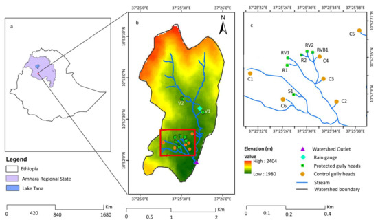
Figure 1.
The location of the study area: (a) Ethiopia and the Amhara Regional State, (b) the 414 ha Ene-Chilala watershed with gullies, and (c) detailed map of gullies in the southern portion of the watershed.
In the Ene-Chilala watershed, mixed farming is practiced in which rainfed cropping is closely integrated with animal husbandry. The major crops are maize (Zea mays), Teff (Eragrostis tef), chickpea (Cicer arietinum), wheat (Triticum aestivum), and barley (Hordeum vulgare). Crop residues are the major source of the livestock feed. Eucalyptus trees are planted around homesteads. Shrubs cover the most degraded soils in the upland. The soils are chromic Luvisols on the hillside and Vertisols in the bottomlands.
Governmental or donor-sponsored soil and water conservation activities had not taken place before 2013 in the Ene-Chilala watershed. Starting in 2013, upland practice installed as part of mandatory community-mobilization government program included stone bunds and 50 cm infiltration furrows on the contour with soil thrown downhill.
2.2. Experimental Design
Fourteen gullies with depths less than 3 m were selected in the Ene-Chilala watershed (Figure 1). All can be found in the periodically saturated grass lands at the valley bottoms. The average gully width was 5.7 m and the average depth was 1.6 m (Table S3). Gully width and depth increased downstream from the head. The slope of the gully head before implementation varied between 75° and 90° (Table S3). The average slope of the land surface above the gully head was 3.25° with a maximum of 5.7°, and the average channel slope was 5.3° with a maximum of 11.3° (Table S3). The longitudinal profile of gully RV1 (see Figure 1 for its location) shows a slope of 6.3° with a total length of 63 m from the gully head to the main stream (Figure S1). Photographs of the RV1 and RVB1 (Figure 1) before treatment are shown in Figure S2a,c.
Six gullies were used as a control and were not treated (C1–C6, Table 1). The head cuts of the eight remaining gullies were regraded to 45° over a three-year period (2013–2015). Following regrading, five practices were applied either by themselves or in combination with each other.

Table 1.
List of remedial practices applied to each gully (see Figure 1 for gully location). The gully names are made up from the practices employed in each gully: C = control; R = riprap; S = regrading only; V = vegetation and B = gully bed stabilization.
Description of Fourteen Gullies and Gully Head Control Practices Implemented
Five gully practices were implemented in all or part of 8 of the 14 gullies (see Figure 1 for their location). The remaining six gullies acted as a “natural” control. Four practices were used to control the retreat of the head: regrading of the gully head and banks (S), placing riprap on the regraded head and banks (R), planting various grasses on the banks (V), and enclosing the area around the head by fencing to keep the cattle out (E). The fifth practice was stabilization of the gully bed downstream of the head (B). These practices are described in more detail first, followed by a description in what gullies they were implemented.
Regrading (S) the gully head involved shaping the heads and banks to a 45° slope (Table 1) using manual labor of local farmers employing hand tools.
Riprap (R) made up of 15–20 cm cobbles, were placed on the regraded gully heads (Table 1, Figure 2) with the larger cobbles at the lower end to prevent toe erosion. The cobbles were collected from the nearby eroded farm fields.
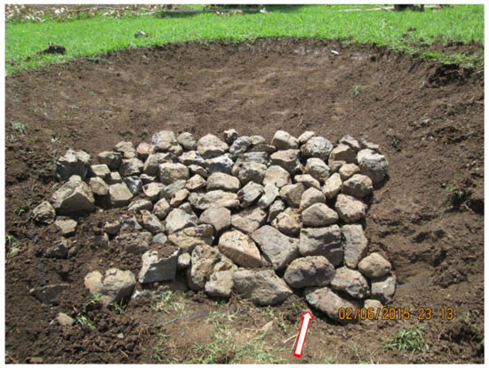
Figure 2.
Initial stages of placing stones at the foot of the gully head to prevent any local gully bed and toe erosion.
Vegetation (V) was planted on the regraded gully heads and banks either with riprap or without. The vegetation consisted of one or more of the following grasses: Sesbania sesban (river hemp) seeded with a 50 cm horizontal spacing, Pennisetum purpureum (elephant grass) planted randomly, and Chrysopogon zizanioides (Vetiver grass) planted with a vertical spacing of 25 cm (Table 1). The grasses were planted after the first rainfall in June. The seed and plant material were provided free of charge by the District Office of Agriculture, Natural Resource Management Department.
Bed Stabilization (B) consisted of regrading gully walls to 45° and the gully bed based on a nearby gully that was not eroding to a stable non-eroding grade of 3.5° using the soil from the bank regrading. The bed was compacted manually with big stones and covered with 3 m × 2 m bamboo (Bambusoideae) sheets and kept in place with stones and wooden pins (Table 1). Ten sheets were used at a cost of 150 Ethiopian Birr (ETB) each (Table 1).
Enclosures (E) fences were placed around the gullies to exclude the cattle from the area to allow for fast re-vegetation and root development. The harvested grass was used as fodder for fattening cattle. The cost of locally available wood and labor for fences were the main cost for establishing enclosures.
The five practices and the control were implemented in the 14 gullies as follows:
C1–C6: Control gullies. Six gullies were not rehabilitated. These gullies were monitored from 2014 to 2016 (Table 1 and Table 2). Head retreat was measured, and gully expansion calculated (Equation (1)). The volume of soil loss was calculated by subtracting the volumes (calculated with Equation (3)) for subsequent years.
Table 2.
Annual gully head retreat, surface area expansion and volume of soil loss from both treated and untreated gully heads. The information of the type of remedial measures and the date of implementation of the gully control practices. Err is the measurement error for the three-year total. The error in the measurement of the gully over a three-year period is 0.3 m for all gullies and therefore not shown. Gully practices are described in Table 1.
S1: Gully with a head that was only regraded. Gully S1 was regraded in 2014 and monitored from 2014–2016. Fences were not installed.
V1 and V2: Gullies with heads that were planted with grasses. Gullies V1 and V2 were planted with Sesbania sesban (river hemp) and Pennisetum purpureum (elephant grass) in 2013 and 2014, respectively (Table 1). The size of the enclosures was just over 3 ha for both gullies (Table 1). More detail can be found in [15].
R1 and R2: Gullies with heads that were regraded and riprapped. Two gully heads (R1 in 2015 and R2 in 2014) were regraded and covered with riprap and enclosed with an area of 0.4 ha (Table 1).
RV1 and RV2: Gullies with heads that were regraded, riprapped and vegetated. The slopes of the regraded heads were protected with riprap and planted with grasses on an area of less than 0.5 ha (RV1 in 2013 and RV2 in 2014). The soil between the rows of Chrysopogon zizanioides grass was seeded with fast growing Sesbania sesban since Chrysopogon zizanioides needs time to establish.
RVB1: Gully with a head that was regraded, riprapped, vegetated, and the gully bed stabilized. All the gully remedial practices were applied in 2014. The redesigned gully bed slope was changed from 7° to 3.5° and the channel depth decreased from 1.75 to 1.2 m.
2.3. Data Collection and Analysis
During the entire study period (2013–2016), the rainfall was measured during the monsoon rain months (i.e., June to September). Rainfall data was collected at 5-min intervals using an automatic tipping bucket rain gage (Watchdog 2000 series with 0.25 mm resolution) installed in the watershed (Figure 1).
The retreat of each gully head was measured weekly using reference pins installed 3 m above the gully head. In addition, the gully dimensions (width, depth, and length) were measured in May, before the start of the rainy season, and in October, at the end of the rain phase, during each of the three years (i.e., 2014 to 2016). Before collecting data on gully dimensions, each observed gully was divided into several uniform linear sections. Then, for each section, the length, the average depth and width were measured. The measurements were taken at distinct transverse slope breaks of each gully cross section for all gullies. The gully surface area was then calculated for each section as
where S = surface area of the gully, = length of the gully segment, Wi = width of the gully at the downstream end of the segment, = width at the upstream end of the gully segment, and n = number of segments. The cross-sectional area of the gully segment, Ai, can be found as
where Dave is the average depth of the gully segment i. The volume of each gully, V, was finally obtained as
The uncertainty of the measured gully length, surface area, and volume were determined for each year. The absolute error in measuring gully length and width were estimated at 0.1 m. In addition, the absolute measurement error of cross sectional area calculation was estimated at 1 m2. The estimated error of length and width measurements were related with the tape meter and handling [5]. To calculate the uncertainty of the gully head retreat, surface area and volume of the gully, we used the propagation error method [29].
Summation or subtraction:
Multiplication:
where δ(X), δ(Y) and δ(Z) are the absolute errors of the variables X, Y, and Z, which for example represent the length, width, and cross-sectional area. The errors from the surface area and volume were determined by applying error propagation Equations (4) and (5) to Equations (1) and (3).
2.4. Profitability of Stabilizing Gullies
The adoption of gully head practices by farmers mainly depends on the perceived short-term economic benefits [30]. Major costs and benefits expressed in monetary values are included in the cost–benefit analysis. Costs include labor and materials needed for constructing the gully head structure and the enclosure fencing. The benefits are the grass harvested as fodder from the enclosure. Based on these costs and benefits, the economic feasibility of gully head remedial practices was evaluated with the net present value (NPV). Although this approach is relatively simple compared with alternative methods such as replacement cost approach, it is appropriate for predicting the profitability of the practice with an initial investment. NPV is defined as the difference between the present value of the benefits and costs, over a defined period at a specified discount rate [31]. The NPV is expressed as
where Bt = accrued benefit at a specified year, Ct = accrued cost at a specified year, r = interest rate, and Nt = number of years.
The NPV is determined assuming that the harvested annual mass of grass from the treated gullies (Table 1) is the same over a seven-year period. This period was selected because soil and water conservation practices last approximately seven years before they become ineffective [32]. A 5% discount rate (interest rate) was used, which is equal to the current deposit rate of the Commercial Bank of Ethiopia. The initial rehabilitation cost taken at year zero consisted of labor and material. The labor cost was estimated from the number of days worked and local daily labor wage rates. The cost of materials such as wood for fencing and rock for riprap, was based on local procurement costs [26]. In addition, the cost of maintenance was assumed equal to 20% of the initial investment. The benefits included the value of the grass harvested from the enclosure as animal fodder. We did not include the monetary value of the trapped sediment as done in the economic assessment by Ayele et al. [15] and Yitbarek et al. [19] because it is not perceived as a benefit by the farmers.
3. Results
In this section, the gully head retreat, the areal expansion, the rate of soil loss and the profitability of the 14 gullies are discussed. The results are summarized in Table 2 and Table 3 for each gully ID is given in Table 1. *—indicates gullies treated at the start of the monitoring period.
Table 3.
Net present value and benefit cost ratio of gully rehabilitation with grass harvested upstream from the gully head in the Ene-Chilala watershed. ETB = Ethiopian Birr, NPV = Net Present Value, and 1 USD = 22 ETB.
3.1. Effectiveness of Gully Head Practices
Control gullies (C1–C6): Over the three-year study period, the median head retreat for all control gullies was 1.2 m a−1 and the average 2.5 m a−1. The annual median rate varied between 0.4 m a−1 in 2015 and 2.3 m a−1 in 2014 (Table 2). The surface area of the control gullies expanded by an average rate of 8.6 m2 a−1 and the average volume increase was almost 20 m3 a−1. The combined area of gully head expansion was 154 ± 36 m2. Gully expansion was smallest in 2015, which had the least amount of rain in the rain phase (414 mm, Figure 3), while the median retreat and surface area expansion were largest for 2014 with 730 mm of rainfall (Table 2). In addition, the monthly rainfall and weekly gully head retreat of all six gullies in Figure 4 showed that the wettest month (August 2014) had greatest head retreat. Despite lower amounts of rainfall in September, relative retreat rates in the upper tow quartiles were elevated (Figure 4) because water tables were near the surface in the valley bottoms (data not shown) due to interflow from the higher areas.
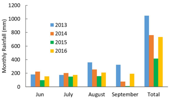
Figure 3.
Monthly rainfall during the monsoon rain phase for the Ene-Chilala watershed from 2013–2016.
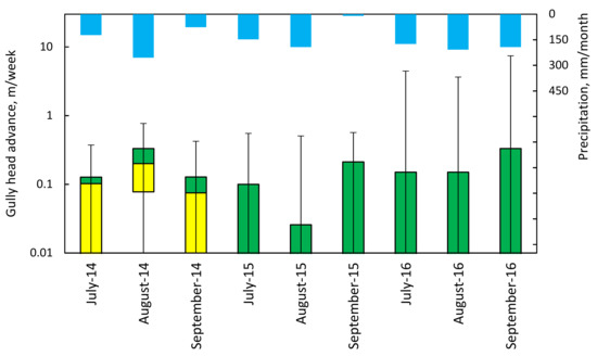
Figure 4.
Relationship between weekly retreat of all control gullies and monthly rainfall from 2014 to 2016 in the Ene-Chilala watershed. The T of the whisker in the maximum weekly retreat in a particular month. The green color are the values in the third quartile of observation of weekly retreats. The boundary between green and yellow is the median, yellow represents the second quartile and the lower whisker is the first quartile. Since it is a logarithmic scale, the gullies with zero retreat are not shown.
Farmers’ practices affected gully expansion rates. For example, farmers directed the outflow of off-contour furrows (locally called “Fesses”) to gully C5 in 2016, which resulted in the greatest head retreat of 20 m a−1 and greatest surface area expansion of 45 m2 a−1 (Table 2 and Table S1).
Gully with regraded head only (S): The average head retreat of gully S1, whose head was regraded in 2014, was 0.5 m a−1, the rate of surface area expansion was 1.3 m2 a−1, and the volume of soil loss was 1.6 m3 a−1 (Table 2). Regrading the gully head in 2014 immediately reduced its retreat during the first rainy season as compared to the control gullies, but steepening of the head resulted in a larger retreat of 1.1 m a−1 in 2015 (Table 2). In 2016, the overland flow into the gully was diverted to gully C5 and grasses in and around the gully emerged that resulted in a reduced gully retreat of 0.4 m a−1 compared to 2015 despite the higher precipitation in 2016 (Figure 3).
Gullies with regraded heads and planted with grasses (V): Gully V1 was the first gully treated in the watershed in 2013, so baseline data were not available. Gully V2 was remedied in 2014. These two gullies were planted with Sesbania sesban (river hemp) and Pennisetum purpureum (elephant grass) (Figure 5a). These gullies are located on the main river branch (see Figure 1), and the overall soil losses are greater than the soil losses for the control gullies. Table 2 shows a continuous head cut retreat before and after the vegetative treatment. The median increase in length for both gullies was 7 m a−1 after treatment. Gully V2 grew by 23 m a−1 before treatment and 4.7 m a−1 after treatment (Table 2 and Table S1). Gully V2 expanded within the saturated soil area that received runoff from upland farmer installed Fesses. The Chrysopogon zizanioides grass was 35 cm tall after three months and 60 to 75 cm tall after five months following planting. The growth rate of Chrysopogon zizanioides was slower than Sesbania sesban and Pennisetum purpureum. Natural grasses grew better compared to planted Chrysopogon zizanioides (Figure 5a). Although vegetation has excellent potential to trap sediments, vegetation in both gullies could not stop the upslope migration of the gully heads (Table 2, Figure 5b), but it likely limited gully incision.
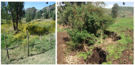
Figure 5.
Gully V1: (a) the enclosure with fence and vegetation; and (b) the gully head moved upslope and connected to cultivated fields.
Gullies with regraded heads protected with riprap and planted with grasses (RV): The heads of gullies RV1 and RV2 were regraded, covered with rock and planted with grasses in 2015. Chrysopogon zizanioides was planted on the regraded head. The retreat stopped after these gullies were riprapped and vegetated (Table 2). Before the practice was installed in 2014, RV1 retreated by 22.5 m and RV2 by 2 m (Table 2) indicating that riprap with vegetation is effective in halting gully head migration (Figure 6).
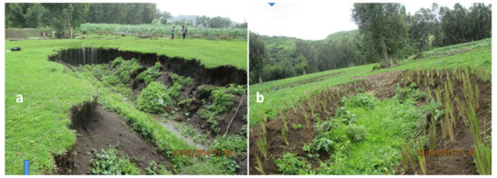
Figure 6.
Gully RV2: (a) without treatment in July 2014 and (b) integrated gully head protection with regrading, stone riprap and vegetation in 2015.
Gully with regraded heads, protected with riprap, planted with grasses, and bed stabilized (RVB1): In 2014, the head of gully RVB1 was regraded, covered with riprap and vegetated. In addition, the gully bed downstream of the head was stabilized. Sesbania sesban and natural grasses grew in the gully. Regrading the gully head and bank increased the top width by 1.3 m (Figure 7a,b). After a year of monitoring, the gully cross section and head position did not change. The reworked soil was compacted in June 2014 during the start of the rainy season; however, the soil strength was low due to soil wetness. In the first three weeks of the rainy season, the bamboo sheets provided effective protection (Figure 7c). The sheets deteriorated and broke up after these three weeks with the remnants kept in place by grasses (Figure 7d). At the end of September 2014, the channel depth had increased by 25 cm (Figure 7d). The time of intervention for regrading and compaction was important because cutting the black soil column into a proper angle in the dry period was challenging. Waiting until the soil gets moist preserves the reshaped loss section, but it is difficult to compact due to soil wetness.
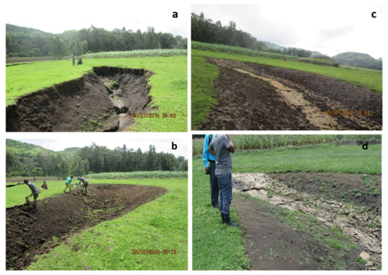
Figure 7.
Gully RVB1 treated with head, bank and bed stabilization measures: (a) the original gully, (b) start of regrading the gully head and bank, (c) after the gully is treated in June 2014, and (d) in October 2014 the bamboo sheet covering the bed has broken down, but the head protection remained in place.
3.2. Profitability of Gully Head Practices
The profitability of gully head stabilization practices and the associated gully enclosure to keep cattle out was determined from animal fodder yield and the cost of rehabilitation (Table 3). According to [15], the income from grass due to enclosure in the same watershed was 3.15 Ethiopian birr (ETB) m−2. Farmers were practicing open grazing in the same area before the area was enclosed and the average benefit of open grazing was 0.5 ETB m−2. The average benefits of grazing were estimated from the local market price to rent grazing land per hectare per year. Therefore, the net income per square meter of grass is the difference between the enclosure and grazing which is 2.65 ETB m−2 (Table S2).
Table S2 and its summary in Table 3 shows the cost and benefits for the calculation of the Net Present Value (NPV) of gully head practices for the eight gullies that produce fodder upstream from the head. The cost of labor at the time of rehabilitation was 40 ETB per day. As indicated in the methodology section, the cost of a structure consists of labor and the costs of the locally available materials used for constructing gully head practice, such as wood and rocks. The net benefit per square meter of gully was determined by subtracting the total cost of the structure and loss of gully area from the total income. The total cost of remediation over a one-year period for the eight gullies was 6590 ETB (see Table S2 for detail). The result showed that an average unit cost of a structure of enclosed area was 53 ETB m−2 (Table 3). The total net benefit was 2170 ETB m−2 from the total upstream area of enclosed gully heads (Table 3 column 6). The NPV varied between 0 to 3550 ETB per gully that was remedied. All were profitable except S1 in which the area was not enclosed (Table 3).
Enclosing the gully head to prevent grazing allowed the deep-rooted grasses to establish and provide soil strength against slipping when saturated. Because of the excess water and soil deposited from upslope, the area is also highly productive, and the grass grown can be shared by the community. Fodder in the dry phase is one of the limited resources for farmers. Before the enclosure was established, the benefit was only for those having livestock through free grazing. Depending on the social fabric in the community, the grass could be a source of income for landless youth groups engaged in income generating activities such as fattening of cattle. Implementing this practice, however, may require that a community member takes the lead and organizes the activities [33,34]. However, in case of conflicts on the distribution of the hay among the community members, enclosures will be abandoned. This was the case for V1 and V2 that were converted back to free grazing in 2017.
4. Discussion
Grading shallow gully heads to a one-to-one slope and covering them with stones, with or without vegetation, stopped the gully retreat in the Ene-Chilala watershed (Table 2). Vegetation without riprap is less effective (Table 2). This is similar to studies in the Loess plateau region of China where structural gully head protection is effective in reducing sediment production [35], while vegetation without riprap does not control the gullies and the retreat continued. As shown by [36], vegetation of gullies more than 3 m deep is not effective because plants do not have dense roots deeper than 3 m.
Gullies over 3 m that are not shallow are stabilized usually with loose rock or gabion check dams which are costly [35]. Following the National Watershed Development Guideline in Ethiopia [37], we estimated the cost of a gabion check dam as 733 ETB m−2 and a loose rock dam as 422 ETB m−2. This compares with 53 ETB m−2 (Table 3) for shallow gullies treated with riprap at the gully head. Farmers can make a profit by halting shallow gullies and enclosing them (Table 3). However, the cost of rehabilitating deeper gullies is beyond the farmers’ means, and these deep gullies are therefore difficult to stop. Thus, by focusing on treating the shallow gullies in watershed management programs, the formation of deep gullies can be slowed down considerably. Stopping the advance of shallow gullies is not without problems since the enclosures for these shallow valley bottom gullies are usually located in communal land that is used for grazing of cattle. Thus, any action on these lands needs permission from the entire community with agreement on the division of the costs and the profits among the community members.
Soil erosion control measures in the past have not been able to halt the increasing sediment concentration in the major rivers. One of the reasons is the emphasis on upland erosion control practices [38] by action agencies based mainly on the traditional view of watershed rehabilitation that one starts at the top of the watershed and then subsequently moves downstream. However, as shown by [39], the sediment pickup in gullies from failed banks can negate any positive effect of hillside soil and water conservation practices upstream. At the same time, as we saw in our study for gullies RV1 in 2014 and C5 in 2016, fesses built in the uplands for carrying of excess rainfall from agricultural land directly contribute to gully advancement (Table 2). Monsieurs et al. [40] had similar observations in the Wanzaye watershed, Northern Ethiopia. Therefore, aspirational watershed management practices require integration of upland and downstream practices that include gully control. One of these aspirational practices, for example, is the diversion of excess water in a farmer’s field through well protected (and maintained) waterways using low-cost measures, such as the gully head protection measures proposed here that will halt gully formation.
To promote these practices, we invited at the end of the study, a group of farmers, development agents and regional natural resource management experts to the site (Figure S3). It was encouraging that after we visited the study watershed in 2017, one year after this study ended, additional practices controlling shallow gully heads were installed. In addition, the Natural Resource Management Department in Amhara and the Amhara Mass Media Agency had shared with other regions in the highlands the information of practices to restore the landscape by control of shallow gully heads. These practices presently can be implemented during the two-month period where farmers are forced to volunteer their labor for implementing upland soil and water conservation practices. Previously that was not the case when only upland practices could be installed.
5. Conclusions
This study assessed effective ways to stop the advancement of shallow gullies into the upland of the 414-ha Ene-Chilala watershed in the Ethiopian highlands over a four-year period. To stop the advancement, gully heads were first regraded to a 45° slope, and then, to stabilize the slope, either riprap or grasses were used. In some gullies, both were applied. Riprap alone was effective for stopping gully advancement, but vegetation alone was not. Using riprap and planting grasses is the preferred long-term solution as the roots can keep the stones in place.
Controlling shallow gully heads was profitable for the farmers provided that the gully heads were enclosed and the land was used for growing fodder that could be used for fattening cattle. Finally, farmers and agency personnel considered the gully control practices so effective in improving income and halt gully retreat that these practices were replicated in nearby watersheds.
Supplementary Materials
The following are available online at http://www.mdpi.com/2073-4441/10/4/389/s1, Table S1. Measured gully dimensions (length, width, and depth) and calculated area and volume of soil; Table S2. The profitability of gully rehabilitation techniques; and Figure S1. Extending gully head treatments through consultative meetings and field visits with community, development agents and regional natural resource management experts in the Ene-Chilala watershed.
Acknowledgments
This study was financially supported by USAID_PEER project (AID-OAA-A-11-00012); the Norman E. Borlaug LEAP, 2015, UC Davis; International Foundation for Science (IFS) Ref. No. W/5844-1; the First Presbyterian Church in Ithaca, New York; the Blue Nile Water Institute, Bahir Dar, Ethiopia; Water, Land and Ecosystem (WLE) research project and Quarit district office of Agriculture. Finally, special thanks to the people living in the Ene-Chilala watershed for their hospitality and participation. In addition, we would like to thank Peggy Stevens for final editing and Bahareh Hassanpour for providing the boxplot.
Author Contributions
M.B.A., S.A.T. and E.J.L. designed the experiments. M.B.A. and G.K.A. collected the data, M.B.A., S.A.T., D.W.A. and T.S.S. analyzed and interpreted the data. M.B.A., T.S.S., S.A.T. and E.J.L. wrote the manuscript with aid of P.S. and W.M. and M.M.M. collaborated with M.B.A. and S.A.T.
Conflicts of Interest
The authors declare no conflict of interest. The sponsors had no role in the design of the study, in the collection, analyses, or interpretation of data, in the writing of the manuscript, and in the decision to publish the results.
References
- Frankl, A.; Poesen, J.; Haile, M.; Deckers, J.; Nyssen, J. Quantifying long-term changes in gully networks and volumes in dryland environments: The case of Northern Ethiopia. Geomorphology 2013, 201, 254–263. [Google Scholar] [CrossRef]
- Li, Z.; Zhang, Y.; Zhu, Q.; Yang, S.; Li, H.; Ma, H. A gully erosion assessment model for the Chinese Loess Plateau based on changes in gully length and area. Catena 2017, 148, 195–203. [Google Scholar] [CrossRef]
- Mukai, S. Gully Erosion Rates and Analysis of Determining Factors: A Case Study from the Semi-arid Main Ethiopian Rift Valley. Land Degrad. Dev. 2017, 28, 602–615. [Google Scholar] [CrossRef]
- Selkimäki, M.; González-Olabarria, J.R. Assessing gully erosion occurrence in forest lands in Catalonia (Spain). Land Degrad. Dev. 2017, 28, 616–627. [Google Scholar] [CrossRef]
- Zegeye, A.D.; Langendoen, E.J.; Stoof, C.R.; Tilahun, S.A.; Dagnew, D.C.; Zimale, F.A.; Guzman, C.D.; Steenhuis, T.S. Morphological dynamics of gully systems in the subhumid Ethiopian Highlands: The Debre Mawi watershed. Soil 2016, 2, 443–458. [Google Scholar] [CrossRef]
- Kraaijvanger, R.; Veldkamp, T. Grain productivity, fertilizer response and nutrient balance of farming systems in Tigray, Ethiopia: A multi-perspective view in relation to soil fertility degradation. Land Degrad. Dev. 2015, 26, 701–710. [Google Scholar] [CrossRef]
- Tebebu, T.; Abiy, A.; Zegeye, A.; Dahlke, H.; Easton, Z.; Tilahun, S.; Collick, A.; Kidnau, S.; Moges, S.; Dadgari, F. Surface and subsurface flow effect on permanent gully formation and upland erosion near Lake Tana in the northern highlands of Ethiopia. Hydrol. Earth Syst. Sci. 2010, 14, 2207–2217. [Google Scholar] [CrossRef]
- Tebebu, T.Y.; Steenhuis, T.S.; Dagnew, D.C.; Guzman, C.D.; Bayabil, H.K.; Zegeye, A.D.; Collick, A.S.; Langan, S.; MacAlister, C.; Langendoen, E.J. Improving efficacy of landscape interventions in the (sub) humid Ethiopian highlands by improved understanding of runoff processes. Fron. Earth Sci. 2015, 3, 49. [Google Scholar] [CrossRef]
- Guzman, C.; Tilahun, S.; Zegeye, A.; Steenhuis, T. Suspended sediment concentration-discharge relationships in the (sub-) humid Ethiopian highlands. Hydrol. Earth Syst. Sci. 2013, 17, 1067. [Google Scholar] [CrossRef]
- Nyssen, J.; Poesen, J.; Moeyersons, J.; Haile, M.; Deckers, J. Dynamics of soil erosion rates and controlling factors in the Northern Ethiopian Highlands-towards a sediment budget. Earth Surf. Process. 2008, 33, 695–711. [Google Scholar] [CrossRef]
- Boix-Fayos, C.; de Vente, J.; Martínez-Mena, M.; Barberá, G.G.; Castillo, V. The impact of land use change and check-dams on catchment sediment yield. Hydrol. Process. 2008, 22, 4922–4935. [Google Scholar] [CrossRef]
- Nyssen, J.; Veyret-Picot, M.; Poesen, J.; Moeyersons, J.; Haile, M.; Deckers, J.; Govers, G. The effectiveness of loose rock check dams for gully control in Tigray, northern Ethiopia. Soil Use Manag. 2004, 20, 55–64. [Google Scholar] [CrossRef]
- Poesen, J. Gully typology and gully control measures in the European loess belt. In Farm Land Erosion: in Temperate Plains Environments and Hills; Elsevier: Amsterdam, The Netherlands, 1993; pp. 221–239. [Google Scholar] [CrossRef]
- Poesen, J.; Nachtergaele, J.; Verstraeten, G.; Valentin, C. Gully erosion and environmental change: Importance and research needs. Catena 2003, 50, 91–133. [Google Scholar] [CrossRef]
- Ayele, G.K.; Gessess, A.A.; Addisie, M.B.; Tilahun, S.A.; Tenessa, D.B.; Langendoen, E.J.; Steenhuis, T.S.; Nicholson, C.F. The economic cost of upland and gully erosion on subsistence agriculture for a watershed in the Ethiopian highlands. Afr. J. Agric. Resour. Econ. Vol. 2016, 10, 265–278. [Google Scholar] [CrossRef]
- Desta, L.; Adugna, B. A Field Guide on Gully Prevention and Control. In Nile Basin Initiative Eastern Nile Subsidiary Action Program (ENSAP); Nile Basin Initiative (NBI): Addis Ababa, Ethiopia, 2012; p. 67. [Google Scholar]
- Erkossa, T.; Haileslassie, A.; MacAlister, C. Enhancing farming system water productivity through alternative land use and improved water management of rainfed agriculture in Vertisol areas. In Proceedings of the Nile Basin Development Challenge Science meeting, Addis Ababa, Ethiopia, 9–10 July 2013. [Google Scholar]
- McHugh, O.V.; Steenhuis, T.S.; Abebe, B.; Fernandes, E.C. Performance of in situ rainwater conservation tillage techniques on dry spell mitigation and erosion control in the drought-prone North Wello zone of the Ethiopian highlands. Soil Tillage Res. 2007, 97, 19–36. [Google Scholar] [CrossRef]
- Yitbarek, T.; Belliethathan, S.; Stringer, L. The onsite cost of gully erosion and cost-benefit of gully rehabilitation: A case study in Ethiopia. Land Degrad. Dev. 2012, 23, 157–166. [Google Scholar] [CrossRef]
- Kidane, D.; Alemu, B. The effect of upstream land use practices on soil erosion and sedimentation in the Upper Blue Nile Basin, Ethiopia. Res. J. Agric. Environ. Manag. 2015, 4, 55–68. [Google Scholar]
- Mitiku, H.; Herweg, K.G.; Stillhardt, B. Sustainable Land Management: A New Approach to Soil and Water Conservation in Ethiopia; Centre for Development and Environment (CDE) and NCCR North-South: Bern, Switzerland, 2006. [Google Scholar]
- Worku, T.; Tripathi, S.K. Watershed Management in Highlands of Ethiopia: A Review. Open Access Libr. J. 2015, 2, 1. [Google Scholar] [CrossRef]
- Belay, M.; Bewket, W. Farmers’ livelihood assets and adoption of sustainable land management practices in north-western highlands of Ethiopia. Int. J. Environ. Stud. 2013, 70, 284–301. [Google Scholar] [CrossRef]
- Addisie, M.B.; Ayele, G.K.; Gessess, A.A.; Tilahun, S.A.; Zegeye, A.D.; Moges, M.M.; Schmitter, P.; Langendoen, E.J.; Steenhuis, T.S. Gully Head Retreat in the Sub-Humid Ethiopian Highlands: The Ene-Chilala Catchment. Land Degrad. Dev. 2017, 28, 1579–1588. [Google Scholar] [CrossRef]
- Zegeye, A.D.; Langendoen, E.J.; Tilahun, S.A.; Merkuri, W.; Poesen, J.; Steenhuis, T.S. Root reinforcement to soils provided by common Ethiopian Highland plants for gully erosion control. Ecohydrology 2018. [Google Scholar] [CrossRef]
- Nyssen, J.; Gebreselassie, S.; Assefa, R.; Deckers, J.; Zenebe, A.; Poesen, J.; Frankl, A. Boulder-Faced Log Dams as an Alternative for Gabion Check Dams in First-Order Ephemeral Streams with Coarse Bed Load in Ethiopia. J. Hydraul. Eng. 2016, 143, 05016005. [Google Scholar] [CrossRef]
- Obiadi, I.; Nwosu, C.; Ajaegwu, N.; Anakwuba, E.; Onuigbo, N.; Akpunonu, E.; Ezim, O. Gully erosion in Anambra State, south east Nigeria: Issues and solution. Int. J. Environ. Sci. 2011, 2, 795–804. [Google Scholar] [CrossRef]
- Adem, A.A.; Aynalem, D.W.; Tilahun, S.A.; Steenhuis, T.S. Predicting reference evaporation for the Ethiopian highlands. J. Water Resour. Prot. 2017, 9, 1244–1269. [Google Scholar] [CrossRef]
- Ku, H.H. Notes on the use of propagation of error formulas. J. Res. Natl. Bur. Stand. C. Eng. Instrum. 1966, 70C, 263–273. [Google Scholar] [CrossRef]
- Giller, K.E.; Witter, E.; Corbeels, M.; Tittonell, P. Conservation agriculture and smallholder farming in Africa: The heretics’ view. Field Crops Res. 2009, 114, 23–34. [Google Scholar] [CrossRef]
- Mishra, P.K.; Rai, S.C. A cost–benefit analysis of indigenous soil and water conservation measures in Sikkim Himalaya, India. Mt. Res. Dev. 2014, 34, 27–35. [Google Scholar] [CrossRef]
- Guzman, C.D.; Zimale, F.A.; Tebebu, T.Y.; Bayabil, H.K.; Tilahun, S.A.; Yitaferu, B.; Rientjes, T.H.; Steenhuis, T.S. Modeling discharge and sediment concentrations after landscape interventions in a humid monsoon climate: The Anjeni watershed in the highlands of Ethiopia. Hydrol. Process. 2017, 31, 1239–1257. [Google Scholar] [CrossRef]
- Peter, K.D.; d’Oleire-Oltmanns, S.; Ries, J.B.; Marzolff, I.; Hssaine, A.A. Soil erosion in gully catchments affected by land-levelling measures in the Souss Basin, Morocco, analysed by rainfall simulation and UAV remote sensing data. Catena 2014, 113, 24–40. [Google Scholar] [CrossRef]
- Krishna, S. Livelihood and Gender: Equity in Community Resource Management; SAGE Publications India: New Delhi, India, 2004. [Google Scholar]
- Jijun, H.; Qiangguo, C.; Guoqiang, L.; Zhongke, W. Integrated erosion control measures and environmental effects in rocky mountainous areas in northern China. Int. J. Sediment Res. 2010, 25, 294–303. [Google Scholar] [CrossRef]
- Zegeye, A.D.; Steenhuis, T.S.; Mekuria, W.; Dagnaw, D.C.; Addisse, M.B.; Tilahun, S.A.; Kasse, T.A. Effect of Gully Headcut Treatment on Sediment Load and Gully Expansion in the Sub Humid Ethiopian Highlands. Environ. Ecol. Res. 2017, 5, 138–144. [Google Scholar] [CrossRef]
- Desta, L.; Carucci, V.; Wendem-Agenehu, A.; Abebe, Y. Community-Based Participatory Watershed Development, a Guideline Annex; Ministry of Agriculture and Rural Development: Addis Ababa, Ethiopia, 2005.
- Zimale, F.A.; Tilahun, S.A.; Tebebu, T.Y.; Guzman, C.D.; Hoang, L.; Schneiderman, E.M.; Langendoen, E.J.; Steenhuis, T.S. Improving watershed management practices in humid regions. Hydrol. Process. 2017, 31, 3294–3301. [Google Scholar] [CrossRef]
- Zegeye, A.D.; Langendoen, E.J.; Guzman, C.D.; Dagnew, D.C.; Amare, S.D.; Tilahun, S.A.; Steenhuis, T.S. Gullies, a critical link in landscape soil loss: A case study in the sub humid highlands of Ethiopia. Land Degrad. Dev. 2018. [Google Scholar] [CrossRef]
- Monsieurs, E.; Dessie, M.; Verhoest, N.E.; Poesen, J.; Adgo, E.; Deckers, J.; Nyssen, J. Impact of draining hilly lands on runoff and on-site erosion: A case study from humid Ethiopia. Earth Surf. Process. 2016, 41, 513–525. [Google Scholar] [CrossRef]
© 2018 by the authors. Licensee MDPI, Basel, Switzerland. This article is an open access article distributed under the terms and conditions of the Creative Commons Attribution (CC BY) license (http://creativecommons.org/licenses/by/4.0/).