Next Issue
Volume 6, June
Previous Issue
Volume 5, December


Land, Volume 6, Issue 1 (March 2017) – 21 articles

Cover Story (view full-size image): 
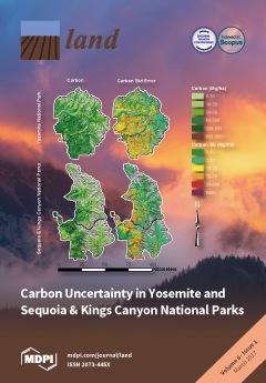
Fire can quickly change forest carbon stocks and landscape level carbon distribution, but few studies have addressed the accuracy of carbon accounting for fire-killed trees. Using detailed vegetation maps, validation plots, fire histories, and Monte Carlo simulations, we estimated aboveground tree carbon along with the uncertainty of that estimate in Yosemite and Sequoia & Kings Canyon National Parks. Although many of our data inputs were more precise than those used in similar studies elsewhere, the uncertainty of the carbon estimates was still greater than ±10%. For carbon inventories to be used meaningfully in policy, more accurate landscape classification methods and improvement in allometric equations for tree species are needed. Unless uncertainties can be lowered, potential management actions that result in small calculated changes in landscape carbon may not be justifiable. Visit Paper here
  • Issues are regarded as officially published after their release is announced to the table of contents alert mailing list.
  • You may sign up for e-mail alerts to receive table of contents of newly released issues.
  • PDF is the official format for papers published in both, html and pdf forms. To view the papers in pdf format, click on the "PDF Full-text" link, and use the free Adobe Reader to open them.
Order results
Result details
Section
Select all
Export citation of selected articles as:
556 KiB  
Article
Can Community Forests Be Compatible With Biodiversity Conservation in Indonesia?
by Agni Klintuni Boedhihartono
Land 2017, 6(1), 21; https://doi.org/10.3390/land6010021 - 14 Mar 2017
Cited by 31 | Viewed by 10555
Abstract
Forest lands in Indonesia are classified as state lands and subject to management under agreements allocated by the Ministry of Environment and Forestry. There has been a long-standing tension between the ministry and local communities who argue that they have traditionally managed large [...] Read more.
Forest lands in Indonesia are classified as state lands and subject to management under agreements allocated by the Ministry of Environment and Forestry. There has been a long-standing tension between the ministry and local communities who argue that they have traditionally managed large areas of forest and should be allowed to continue to do so. A series of recent legal and administrative decisions are now paving the way for the allocation of forests to local communities. There is a hypothesis that the communities will protect the forests against industrial conversion and that they will also conserve biodiversity. This hypothesis needs to be closely examined. Conservation of biodiversity and management for local benefits are two different and potentially conflicting objectives. This paper reviews examples of forests managed by local communities in Indonesia and concludes that there is very limited information available on the conservation of natural biodiversity in these forests. I conclude that more information is needed on the status of biodiversity in community managed forests. When forests are allocated for local management, special measures need to be in place to ensure that biodiversity values are monitored and maintained. Full article
(This article belongs to the Special Issue Biodiversity in Locally Managed Lands)
Show Figures

Figure 1

9558 KiB  
Article
Understanding Land Use and Land Cover Dynamics from 1976 to 2014 in Yellow River Delta
by Baolei Zhang, Qiaoyun Zhang, Chaoyang Feng, Qingyu Feng and Shumin Zhang
Land 2017, 6(1), 20; https://doi.org/10.3390/land6010020 - 13 Mar 2017
Cited by 35 | Viewed by 8206
Abstract
Long-term intensive land use/cover changes (LUCCs) of the Yellow River Delta (YRD) have been happening since the 1960s. The land use patterns of the LUCCs are crucial for bio-diversity conservation and/or sustainable development. This study quantified patterns of the LUCCs, explored the systematic [...] Read more.
Long-term intensive land use/cover changes (LUCCs) of the Yellow River Delta (YRD) have been happening since the 1960s. The land use patterns of the LUCCs are crucial for bio-diversity conservation and/or sustainable development. This study quantified patterns of the LUCCs, explored the systematic transitions, and identified wetland change trajectory for the period 1976–2014 in the YRD. Landsat imageries of 1976, 1984, 1995, 2006, and 2014 were used to derive nine land use classes. Post classification change detection analysis based on enhanced transition matrix was applied to identify land use dynamics and trajectory of wetland change. The five cartographic outputs for changes in land use underlined major decreases in natural wetland areas and increases in artificial wetland and non-wetland, especially aquafarms, salt pans and construction lands. The systematic transitions in the YRD were wetland degradation, wetland artificialization, and urbanization. Wetland change trajectory results demonstrated that the main wetland changes were wetland degradation and wetland artificialization. Coastline change is the subordinate reason for natural wetland degradation in comparison with human activities. The results of this study allowed for an improvement in the understanding of the LUCC processes and enabled researchers and planners to focus on the most important signals of systematic landscape transitions while also allowing for a better understanding of the proximate causes of changes. Full article
(This article belongs to the Special Issue Urban Land Systems: An Ecosystems Perspective)
Show Figures

Graphical abstract

3211 KiB  
Article
Characterizing Spatial Neighborhoods of Refugia Following Large Fires in Northern New Mexico USA
by Sandra L. Haire, Jonathan D. Coop and Carol Miller
Land 2017, 6(1), 19; https://doi.org/10.3390/land6010019 - 07 Mar 2017
Cited by 20 | Viewed by 5843
Abstract
The spatial patterns resulting from large fires include refugial habitats that support surviving legacies and promote ecosystem recovery. To better understand the diverse ecological functions of refugia on burn mosaics, we used remotely sensed data to quantify neighborhood patterns of areas relatively unchanged [...] Read more.
The spatial patterns resulting from large fires include refugial habitats that support surviving legacies and promote ecosystem recovery. To better understand the diverse ecological functions of refugia on burn mosaics, we used remotely sensed data to quantify neighborhood patterns of areas relatively unchanged following the 2011 Las Conchas fire. Spatial patterns of refugia measured within 10-ha moving windows varied across a gradient from areas of high density, clustered in space, to sparsely populated neighborhoods that occurred in the background matrix. The scaling of these patterns was related to the underlying structure of topography measured by slope, aspect and potential soil wetness, and spatially varying climate. Using a nonmetric multidimensional scaling analysis of species cover data collected post-Las Conchas, we found that trees and forest associates were present across the refugial gradient, but communities also exhibited a range of species compositions and potential functions. Spatial patterns of refugia quantified for three previous burns (La Mesa 1977, Dome 1996, Cerro Grande 2000) were dynamic between fire events, but most refugia persisted through at least two fires. Efforts to maintain burn heterogeneity and its ecological functions can begin with identifying where refugia are likely to occur, using terrain-based microclimate models, burn severity models and available field data. Full article
(This article belongs to the Special Issue Wildland Fires)
Show Figures

Figure 1

6386 KiB  
Article
Multi-Criteria Assessment of Land Cover Dynamic Changes in Halgurd Sakran National Park (HSNP), Kurdistan Region of Iraq, Using Remote Sensing and GIS
by Rahel Hamad, Heiko Balzter and Kamal Kolo
Land 2017, 6(1), 18; https://doi.org/10.3390/land6010018 - 07 Mar 2017
Cited by 20 | Viewed by 7076
Abstract
Halgurd Sakran National Park (HSNP) is Iraq’s first designated national park, located in the Kurdistan Region, which has suffered multiple armed conflicts over the past decades. This study assesses how vegetation dynamics have affected the landscape structure and composition of the core zone [...] Read more.
Halgurd Sakran National Park (HSNP) is Iraq’s first designated national park, located in the Kurdistan Region, which has suffered multiple armed conflicts over the past decades. This study assesses how vegetation dynamics have affected the landscape structure and composition of the core zone of the park over the last 31 years. Spatio-temporal changes in land cover were mapped for three points in time using remote sensing, geographic information systems (GIS), and landscape metrics. Land cover changes were mapped using random forest classifications of satellite images from Landsat 5 TM, Landsat 7 ETM+, and Landsat 8 LDCM acquired in 1984, 1998, and 2015. Five landscape pattern metrics were analysed at class and landscape levels in order to quantify landscape patterns arising from land use and land cover (LULC) change in HSNP using FRAGSTATS 4.2. These landscape pattern metrics were patch metrics, area metrics, shape metrics interspersion/juxtaposition and contagion metrics and diversity metrics. Significant changes in cultivated areas after 1991 were observed, which indicate the role of anthropogenic activities in land cover change. Areas of bare surface and forest lands declined and became more fragmented in 1984 and 1998 while, at the same time, cultivated areas increased, with a continuing fragmentation of pasture land. Internal migration of people was one of the major drivers of LULC change. The results reveal that significant LULC changes in terms of composition and spatial structure over the 31-year period have occurred in the designated protected area. Landscape metrics were able to assess the trend of spatial patchiness over the studied period. A discussion of the significance of changes in land use systems for understanding the causes and consequences of change is provided. Full article
Show Figures

Figure 1

15402 KiB  
Article
Identifying Employment Subcenters: The Method of Exponentially Declining Cutoffs
by Jifei Ban, Richard Arnott and Jacob L. Macdonald
Land 2017, 6(1), 17; https://doi.org/10.3390/land6010017 - 01 Mar 2017
Cited by 5 | Viewed by 4696
Abstract
The standard method of identifying subcenters is due to Giuliano and Small. While simple, robust and easy to apply, because it uses absolute employment density and employment cutoffs, it identifies “too few” subcenters at the metropolitan periphery. This paper presents a straight forward [...] Read more.
The standard method of identifying subcenters is due to Giuliano and Small. While simple, robust and easy to apply, because it uses absolute employment density and employment cutoffs, it identifies “too few” subcenters at the metropolitan periphery. This paper presents a straight forward modification to this method aimed at remedying this weakness. The modification entails using cutoffs that decline exponentially with distance from the metropolitan center, thereby giving consideration to the employment density of a location relative to that of its locality. In urban studies, there is a long history of estimating employment density “gradients”, the exponential rate at which employment density declines with distance from the metropolitan center. These density gradients differ substantially across metropolitan areas and across time for a particular metropolitan area. Applying our method to Los Angeles, Calgary and Paris, we have found that using cutoffs that decline exponentially at one-half the estimated density gradients achieves an appealing balance between subcenters identified close to the metropolitan center and those identified at the metropolitan periphery. Many other methods of subcenter identification have been proposed that use sophisticated econometric procedures. Our method should appeal to practitioners who are looking for a simple method to apply. Full article
Show Figures

Figure 1

761 KiB  
Article
Resistance and Contingent Contestations to Large-Scale Land Concessions in Southern Laos and Northeastern Cambodia
by Ian G. Baird
Land 2017, 6(1), 16; https://doi.org/10.3390/land6010016 - 26 Feb 2017
Cited by 45 | Viewed by 6251
Abstract
Over the last decade, there have been considerable concerns raised regarding the social and environmental impacts of large-scale land concessions for plantation development in various parts of the world, especially in the tropics, including in Laos and Cambodia. However, there is still much [...] Read more.
Over the last decade, there have been considerable concerns raised regarding the social and environmental impacts of large-scale land concessions for plantation development in various parts of the world, especially in the tropics, including in Laos and Cambodia. However, there is still much to learn about the various connections and interactions associated with reactions to what are often referred to as “land grabs”, and the ways they are associated or not associated with broader social movements and networks opposed to land grabbing. There is also the need to develop language for discussing these circumstances, something I aim to contribute to in this article. Here, I present four different cases of types of resistance, or what I refer to as contingent contestations, to land concessions in southern Laos and northeastern Cambodia (two from each country), focusing on the perspectives and associated strategies of smallholder farmers, but without ignoring broader issues. I consider the roles of locals in these contestations, through emphasizing the importance of histories, identities/ethnicities, politics, and geography in determining the types of responses to these land deals that emerge, and the strategies that are adopted for contesting these developments. Full article
Show Figures

Figure 1

225 KiB  
Essay
Anthropogenic Landscapes, Human Action and the Process of Co-Construction with other Species: Making Anthromes in the Anthropocene
by Agustín Fuentes and Marcus Baynes-Rock
Land 2017, 6(1), 15; https://doi.org/10.3390/land6010015 - 24 Feb 2017
Cited by 24 | Viewed by 9362
Abstract
We are in the Anthropocene. For millennia, human actions have been shaping the world to the degree that they are inscribed in the geological and ecological record. Recently, this has been occurring with increasing speed and influence. This means we need to be [...] Read more.
We are in the Anthropocene. For millennia, human actions have been shaping the world to the degree that they are inscribed in the geological and ecological record. Recently, this has been occurring with increasing speed and influence. This means we need to be asking integrative and effective questions about the world and how we relate to and in it. Human niche construction has broad and deep effects not just on landscapes and environments, but on the myriad of other beings sharing space with us. Humans are self-appointed ecosystem managers and lead actors in seeking sustainability for planetary and local ecosystems. In order to accomplish this, we need to better understand how anthromes are shaped, inhabited and altered. To this end, we present two different examples of anthropogenic landscapes; one in Ethiopia and one in Bali, Indonesia. These are landscapes that are co-constructed by multiple species through complex webs of ecologies, economies and histories and represent the way that humans are drawn into relationships with non-humans; relationships which in turn alter landscapes. Full article
(This article belongs to the Special Issue Anthropogenic Biomes)
1264 KiB  
Review
Characterizing Islandscapes: Conceptual and Methodological Challenges Exemplified in the Mediterranean
by Ioannis N. Vogiatzakis, Maria Zomeni and A. M. Mannion
Land 2017, 6(1), 14; https://doi.org/10.3390/land6010014 - 17 Feb 2017
Cited by 19 | Viewed by 5867
Abstract
Islands across the world have evolved at the interface between land and sea, thus comprising landscapes and seascapes. Many islands have also been influenced by anthropogenic factors, which have given rise to mosaics of anthromes (sensu Ellis and Ramankutty). These elements of [...] Read more.
Islands across the world have evolved at the interface between land and sea, thus comprising landscapes and seascapes. Many islands have also been influenced by anthropogenic factors, which have given rise to mosaics of anthromes (sensu Ellis and Ramankutty). These elements of landscapes, seascapes, and cultural impacts in varied proportions, generate unique environments which merit a unique term: islandscapes. The use of the term islandscape is advocated as the only term which encompasses all of the constituent components of an island, in a holistic manner. The aim of the paper is to evaluate the applicability of existing landscape and seascape character assessment methodologies in an island context, and to propose a methodological framework for mapping the space which defines the term ‘islandscape’. The challenges and opportunities stemming from the use of the term are exemplified with reference to the Mediterranean islands. Full article
(This article belongs to the Special Issue Anthropogenic Biomes)
Show Figures

Figure 1

5832 KiB  
Article
Toward a Global Classification of Coastal Anthromes
by Eli D. Lazarus
Land 2017, 6(1), 13; https://doi.org/10.3390/land6010013 - 10 Feb 2017
Cited by 16 | Viewed by 8975
Abstract
Given incontrovertible evidence that humans are the most powerful agents of environmental change on the planet, research has begun to acknowledge and integrate human presence and activity into updated descriptions of the world’s biomes as “anthromes”. Thus far, a classification system for anthromes [...] Read more.
Given incontrovertible evidence that humans are the most powerful agents of environmental change on the planet, research has begun to acknowledge and integrate human presence and activity into updated descriptions of the world’s biomes as “anthromes”. Thus far, a classification system for anthromes is limited to the terrestrial biosphere. Here, I present a case for the consideration and validity of coastal anthromes. Every coastal environment on Earth is subject to direct and indirect human modification and disturbance. Despite the legacy, ubiquity, and pervasiveness of human interactions with coastal ecosystems, coastal anthromes still lack formal definition. Following the original argument and framework for terrestrial anthromes, I outline a set of coastal anthrome classifications that dovetail with terrestrial and marine counterparts. Recognising coastal environments as complex and increasingly vulnerable anthropogenic systems is a fundamental step toward understanding their modern dynamics—and, by extension, realising opportunities for and limits to their resilience. Full article
(This article belongs to the Special Issue Anthropogenic Biomes)
Show Figures

Figure 1

3685 KiB  
Article
Estate Crops More Attractive than Community Forests in West Kalimantan, Indonesia
by James D. Langston, Rebecca A. Riggs, Yazid Sururi, Terry Sunderland and Muhammad Munawir
Land 2017, 6(1), 12; https://doi.org/10.3390/land6010012 - 08 Feb 2017
Cited by 22 | Viewed by 9562
Abstract
Smallholder farmers and indigenous communities must cope with the opportunities and threats presented by rapidly spreading estate crops in the frontier of the agricultural market economy. Smallholder communities are subject to considerable speculation by outsiders, yet large-scale agriculture presents tradeoffs that they must [...] Read more.
Smallholder farmers and indigenous communities must cope with the opportunities and threats presented by rapidly spreading estate crops in the frontier of the agricultural market economy. Smallholder communities are subject to considerable speculation by outsiders, yet large-scale agriculture presents tradeoffs that they must navigate. We initiated a study in Sintang, West Kalimantan in 2012 and have returned annually for the last four years, building the baselines for a longer-term landscape approach to reconciling conservation and development tradeoffs in situ. Here, the stakeholders are heterogeneous, yet the land cover of the landscape is on a trajectory towards homogenous mono-cropping systems, primarily either palm oil or rubber. In one village on the frontier of the agricultural market economy, natural forests remain managed by the indigenous and local community but economics further intrude on forest use decisions. Conservation values are declining and the future of the forest is uncertain. As such, the community is ultimately attracted to more economically attractive uses of the land for local development oil palm or rubber mono-crop farms. We identify poverty as a threat to community-managed conservation success in the face of economic pressures to convert forest to intensive agriculture. We provide evidence that lucrative alternatives will challenge community-managed forests when prosperity seems achievable. To alleviate this trend, we identify formalized traditional management and landscape governance solutions to nurture a more sustainable landscape transition. Full article
(This article belongs to the Special Issue Biodiversity in Locally Managed Lands)
Show Figures

Figure 1

9132 KiB  
Article
Late Neolithic Agriculture in Temperate Europe—A Long-Term Experimental Approach
by Manfred Rösch, Harald Biester, Arno Bogenrieder, Eileen Eckmeier, Otto Ehrmann, Renate Gerlach, Mathias Hall, Christoph Hartkopf-Fröder, Ludger Herrmann, Birgit Kury, Jutta Lechterbeck, Wolfram Schier and Erhard Schulz
Land 2017, 6(1), 11; https://doi.org/10.3390/land6010011 - 07 Feb 2017
Cited by 15 | Viewed by 8641
Abstract
Long-term slash-and-burn experiments, when compared with intensive tillage without manuring, resulted in a huge data set relating to potential crop yields, depending on soil quality, crop type, and agricultural measures. Cultivation without manuring or fallow phases did not produce satisfying yields, and mono-season [...] Read more.
Long-term slash-and-burn experiments, when compared with intensive tillage without manuring, resulted in a huge data set relating to potential crop yields, depending on soil quality, crop type, and agricultural measures. Cultivation without manuring or fallow phases did not produce satisfying yields, and mono-season cropping on freshly cleared and burned plots resulted in rather high yields, comparable to those produced during modern industrial agriculture - at least ten-fold the ones estimated for the medieval period. Continuous cultivation on the same plot, using imported wood from adjacent areas as fuel, causes decreasing yields over several years. The high yield of the first harvest of a slash-and-burn agriculture is caused by nutrient input through the ash produced and mobilization from the organic matter of the topsoil, due to high soil temperatures during the burning process and higher topsoil temperatures due to the soil’s black surface. The harvested crops are pure, without contamination of any weeds. Considering the amount of work required to fight weeds without burning, the slash-and-burn technique yields much better results than any other tested agricultural approach. Therefore, in dense woodland, without optimal soils and climate, slash-and-burn agriculture seems to be the best, if not the only, feasible method to start agriculture, for example, during the Late Neolithic, when agriculture expanded from the loess belt into landscapes less suitable for agriculture. Extensive and cultivation with manuring is more practical in an already-open landscape and with a denser population, but its efficiency in terms of the ratio of the manpower input to food output, is worse. Slash-and-burn agriculture is not only a phenomenon of temperate European agriculture during the Neolithic, but played a major role in land-use in forested regions worldwide, creating anthromes on a huge spatial scale. Full article
(This article belongs to the Special Issue Anthropogenic Biomes)
Show Figures

Figure 1

9040 KiB  
Article
Fire and the Distribution and Uncertainty of Carbon Sequestered as Aboveground Tree Biomass in Yosemite and Sequoia & Kings Canyon National Parks
by James A. Lutz, John R. Matchett, Leland W. Tarnay, Douglas F. Smith, Kendall M. L. Becker, Tucker J. Furniss and Matthew L. Brooks
Land 2017, 6(1), 10; https://doi.org/10.3390/land6010010 - 27 Jan 2017
Cited by 20 | Viewed by 6401
Abstract
Fire is one of the principal agents changing forest carbon stocks and landscape level distributions of carbon, but few studies have addressed how accurate carbon accounting of fire-killed trees is or can be. We used a large number of forested plots (1646), detailed [...] Read more.
Fire is one of the principal agents changing forest carbon stocks and landscape level distributions of carbon, but few studies have addressed how accurate carbon accounting of fire-killed trees is or can be. We used a large number of forested plots (1646), detailed selection of species-specific and location-specific allometric equations, vegetation type maps with high levels of accuracy, and Monte Carlo simulation to model the amount and uncertainty of aboveground tree carbon present in tree species (hereafter, carbon) within Yosemite and Sequoia & Kings Canyon National Parks. We estimated aboveground carbon in trees within Yosemite National Park to be 25 Tg of carbon (C) (confidence interval (CI): 23–27 Tg C), and in Sequoia & Kings Canyon National Park to be 20 Tg C (CI: 18–21 Tg C). Low-severity and moderate-severity fire had little or no effect on the amount of carbon sequestered in trees at the landscape scale, and high-severity fire did not immediately consume much carbon. Although many of our data inputs were more accurate than those used in similar studies in other locations, the total uncertainty of carbon estimates was still greater than ±10%, mostly due to potential uncertainties in landscape-scale vegetation type mismatches and trees larger than the ranges of existing allometric equations. If carbon inventories are to be meaningfully used in policy, there is an urgent need for more accurate landscape classification methods, improvement in allometric equations for tree species, and better understanding of the uncertainties inherent in existing carbon accounting methods. Full article
(This article belongs to the Special Issue Wildland Fires)
Show Figures

Graphical abstract

1333 KiB  
Letter
Urban Growth Dynamics in Perth, Western Australia: Using Applied Remote Sensing for Sustainable Future Planning
by Andrew MacLachlan, Eloise Biggs, Gareth Roberts and Bryan Boruff
Land 2017, 6(1), 9; https://doi.org/10.3390/land6010009 - 24 Jan 2017
Cited by 22 | Viewed by 13921
Abstract
Earth observation data can provide valuable assessments for monitoring the spatial extent of (un)sustainable urban growth of the world’s cities to better inform planning policy in reducing associated economic, social and environmental costs. Western Australia has witnessed rapid economic expansion since the turn [...] Read more.
Earth observation data can provide valuable assessments for monitoring the spatial extent of (un)sustainable urban growth of the world’s cities to better inform planning policy in reducing associated economic, social and environmental costs. Western Australia has witnessed rapid economic expansion since the turn of the century founded upon extensive natural resource extraction. Thus, Perth, the state capital of Western Australia, has encountered significant population and urban growth in response to the booming state economy. However, the recent economic slowdown resulted in the largest decrease in natural resource values that Western Australia has ever experienced. Here, we present multi-temporal urban expansion statistics from 1990 to 2015 for Perth, derived from Landsat imagery. Current urban estimates used for future development plans and progress monitoring of infill and density targets are based upon aggregated census data and metrics unrepresentative of actual land cover change, underestimating overall urban area. Earth observation provides a temporally consistent methodology, identifying areal urban area at higher spatial and temporal resolution than current estimates. Our results indicate that the spatial extent of the Perth Metropolitan Region has increased 45% between 1990 and 2015, over 320 km2. We highlight the applicability of earth observation data in accurately quantifying urban area for sustainable targeted planning practices. Full article
(This article belongs to the Special Issue Urban Land Systems: An Ecosystems Perspective)
Show Figures

Figure 1

4585 KiB  
Article
Habitat Loss on Rondon’s Marmoset Potential Distribution
by Jose Manuel Ochoa-Quintero, Charlotte H. Chang, Toby A. Gardner, Mariluce Rezende Messias, William J. Sutherland and Fernanda A. C. Delben
Land 2017, 6(1), 8; https://doi.org/10.3390/land6010008 - 23 Jan 2017
Cited by 3 | Viewed by 5332
Abstract
The Amazon basin is one of the most biologically diverse places on earth. However, agricultural expansion and infrastructure development have led to widespread deforestation that threatens the survival of many taxa. Conservation strategies to contest these threats include protected areas and environmental legislation. [...] Read more.
The Amazon basin is one of the most biologically diverse places on earth. However, agricultural expansion and infrastructure development have led to widespread deforestation that threatens the survival of many taxa. Conservation strategies to contest these threats include protected areas and environmental legislation. Nevertheless, the basic biology of many taxa is largely unknown, which poses an immense challenge when devising effective strategies to safeguard such species in the long-term. This is particularly true for primates. Monkeys from the genus Mico are poorly studied with half of the currently known species being described after 1976, and their distribution and threats remain poorly understood. Using the model Maxent, we re-evaluated the distribution range for Rondon’s marmoset, one of the most threatened species in this genus. Our results estimated a distribution that is 15,500 km2 smaller than previously described for this species (68,649 km2). Furthermore, much of its modeled distribution (71%) lies outside of protected areas. Agriculture expansion and infrastructure development have converted/destroyed 20,532 km2 of forest within its range (38%) mainly in areas without protection. Another 10,316 km2 of forest is projected to be cleared by 2040 under current deforestation patterns. The expected cumulative loss of over 50% of its range size in the coming 15 years raise awareness about the threaten category of this species. In the absence of new protected areas, it remains to be seen whether Rondon’s marmoset can be effectively conserved in remaining fragments of forest in farmlands. Full article
Show Figures

Figure 1

1191 KiB  
Article
The Politics of Land Use in the Korup National Park
by Siewe Siewe, Jacqueline M. Vadjunec and Beth Caniglia
Land 2017, 6(1), 7; https://doi.org/10.3390/land6010007 - 19 Jan 2017
Cited by 7 | Viewed by 7801
Abstract
Recently, the call to combine land change science (LCS) and political ecology (PE) in the study of human-environment interactions has been widely discussed by scientists from both subfields of geography. In this paper, we use a hybrid ecology framework to examine the effects [...] Read more.
Recently, the call to combine land change science (LCS) and political ecology (PE) in the study of human-environment interactions has been widely discussed by scientists from both subfields of geography. In this paper, we use a hybrid ecology framework to examine the effects of conservation policies on the environment and the livelihood of the people of the Korup National Park (KNP). Using techniques in both PE and LCS, our results show that conservation policies, politics, and population are the primary drivers of environmental change in the KNP. We conclude by arguing that a deeper understanding can be garnered by combining LCS and PE approaches to analyze and contribute to the people and parks debate. Full article
Show Figures

Figure 1

184 KiB  
Review
Will Biodiversity Be Conserved in Locally-Managed Forests?
by Jeffrey Sayer, Chris Margules and Agni Klintuni Boedhihartono
Land 2017, 6(1), 6; https://doi.org/10.3390/land6010006 - 13 Jan 2017
Cited by 13 | Viewed by 6508
Abstract
Recent decades have seen a rapid movement towards decentralising forest rights and tenure to local communities and indigenous groups in both developing and developed nations. Attribution of local and community rights to forests appears to be gathering increasing momentum in many tropical developing [...] Read more.
Recent decades have seen a rapid movement towards decentralising forest rights and tenure to local communities and indigenous groups in both developing and developed nations. Attribution of local and community rights to forests appears to be gathering increasing momentum in many tropical developing countries. Greater local control of forest resources is a response to the failure of government agencies to exercise adequate stewardship over forests and to ensure that the values of all stakeholders are adequately protected. We reviewed evidence of the impact of decentralised forest management on the biodiversity values of forests and conclude that special measures are needed to protect these values. There are trade-offs between shorter-term local needs for forest lands and products and longer-term global needs for biodiversity and other environmental values. We present evidence of local forest management leading to declining forest integrity with negative impacts on both local forest users and the global environment. We advocate greater attention to measures to ensure protection of biodiversity in locally-managed forests. Full article
(This article belongs to the Special Issue Biodiversity in Locally Managed Lands)
150 KiB  
Editorial
Acknowledgement to Reviewers of Land in 2016
by Land Editorial Office
Land 2017, 6(1), 5; https://doi.org/10.3390/land6010005 - 10 Jan 2017
Cited by 24 | Viewed by 2630
Abstract
The editors of Land would like to express their sincere gratitude to the following reviewers for assessing manuscripts in 2016.[...] Full article
1112 KiB  
Article
Analysis of Vegetation Phytosociological Characteristics and Soil Physico-Chemical Conditions in Harishin Rangelands of Eastern Ethiopia
by Haftay Hailu
Land 2017, 6(1), 4; https://doi.org/10.3390/land6010004 - 10 Jan 2017
Cited by 20 | Viewed by 6891
Abstract
The objective of this study is to analyse the phytodiversity, distribution, herb biomass and physico-chemical conditions of the vegetation system in the context of communal continuous open grazing and enclosed grazing management practices in the Harishin rangelands of Eastern Ethiopia. A total of [...] Read more.
The objective of this study is to analyse the phytodiversity, distribution, herb biomass and physico-chemical conditions of the vegetation system in the context of communal continuous open grazing and enclosed grazing management practices in the Harishin rangelands of Eastern Ethiopia. A total of 58 herbaceous species and 11 woody species were recorded in the study area. Analysis of Importance Value Index for two management practices was represented by different combinations of species with varied dominance. The herbs’ diversity–dominance curve revealed a lognormal distribution in both managements practices. The overview of distribution patterns for most of the species layer showed contiguous growth and a clumped distribution pattern. Species diversity, richness, herb biomass, basal cover and soil physico-chemical attributes showed a distinct separation in relation to grazing management practices. Based on the findings, one can conclude that the establishment of enclosures has a positive impact in restoring rangeland vegetation diversity, distribution, in increasing herb productivity and in boosting soil fertility. Full article
Show Figures

Figure 1

12983 KiB  
Article
Hydrological Response to ~30 years of Agricultural Surface Water Management
by Giulia Sofia and Paolo Tarolli
Land 2017, 6(1), 3; https://doi.org/10.3390/land6010003 - 03 Jan 2017
Cited by 24 | Viewed by 7289
Abstract
Amongst human practices, agricultural surface-water management systems represent some of the largest integrated engineering works that shaped floodplains during history, directly or indirectly affecting the landscape. As a result of changes in agricultural practices and land use, many drainage networks have changed producing [...] Read more.
Amongst human practices, agricultural surface-water management systems represent some of the largest integrated engineering works that shaped floodplains during history, directly or indirectly affecting the landscape. As a result of changes in agricultural practices and land use, many drainage networks have changed producing a greater exposure to flooding with a broad range of impacts on society, also because of climate inputs coupling with the human drivers. This research focuses on three main questions: which kind of land use changes related to the agricultural practices have been observed in the most recent years (~30 years)? How does the influence on the watershed response to land use and land cover changes depend on the rainfall event characteristics and soil conditions, and what is their related significance? The investigation presented in this work includes modelling the water infiltration due to the soil properties and analysing the distributed water storage offered by the agricultural drainage system in a study area in Veneto (north-eastern Italy). The results show that economic changes control the development of agro-industrial landscapes, with effects on the hydrological response. Key elements that can enhance or reduce differences are the antecedent soil conditions and the climate characteristics. Criticalities should be expected for intense and irregular rainfall events, and for events that recurrently happen. Agricultural areas might be perceived to be of low priority when it comes to public funding of flood protection, compared to the priority given to urban ones. These outcomes highlight the importance of understanding how agricultural practices can be the driver of or can be used to avoid, or at least mitigate, flooding. The proposed methods can be valuable tools in evaluating the costs and benefits of the management of water in agriculture to inform better policy decision-making. Full article
Show Figures

Figure 1

4027 KiB  
Article
Conservation Benefits of Tropical Multifunctional Land-Uses in and Around a Forest Protected Area of Bangladesh
by Sharif A. Mukul and Narayan Saha
Land 2017, 6(1), 2; https://doi.org/10.3390/land6010002 - 01 Jan 2017
Cited by 20 | Viewed by 7682
Abstract
Competing interests in land for agriculture and commodity production in tropical human-dominated landscapes make forests and biodiversity conservation particularly challenging. Establishment of protected areas in this regard is not functioning as expected due to exclusive ecological focus and poor recognition of local people’s [...] Read more.
Competing interests in land for agriculture and commodity production in tropical human-dominated landscapes make forests and biodiversity conservation particularly challenging. Establishment of protected areas in this regard is not functioning as expected due to exclusive ecological focus and poor recognition of local people’s traditional forest use and dependence. In recent years, multifunctional land-use systems such as agroforestry have widely been promoted as an efficient land-use in such circumstances, although their conservation effectiveness remains poorly investigated. We undertake a rapid biodiversity survey to understand the conservation value of four contrasting forms of local land-use, namely: betel leaf (Piper betle) agroforestry; lemon (Citrus limon) agroforestry; pineapple (Ananas comosus) agroforestry; and, shifting cultivation–fallow managed largely by the indigenous communities in and around a highly diverse forest protected area of Bangladesh. We measure the alpha and beta diversity of plants, birds, and mammals in these multifunctional land-uses, as well as in the old-growth secondary forest in the area. Our study finds local land-use critical in conserving biodiversity in the area, with comparable biodiversity benefits as those of the old-growth secondary forest. In Bangladesh, where population pressure and rural people’s dependence on forests are common, multifunctional land-uses in areas of high conservation priority could potentially be used to bridge the gap between conservation and commodity production, ensuring that the ecological integrity of such landscapes will be altered as little as possible. Full article
(This article belongs to the Special Issue Biodiversity in Locally Managed Lands)
Show Figures

Figure 1

1603 KiB  
Article
Unexpected Interactions between Agricultural and Forest Sectors through International Trade: Wood Pallets and Agricultural Exports in Costa Rica
by Isaline Jadin, Patrick Meyfroidt, Juan Carlos Zamora Pereira and Eric F. Lambin
Land 2017, 6(1), 1; https://doi.org/10.3390/land6010001 - 24 Dec 2016
Cited by 6 | Viewed by 7813
Abstract
International market forces have played an increasingly important role in shaping land use dynamics through complex supply chains. In Costa Rica, the shift from a net loss to a net gain in forest cover was facilitated by forest plantations and the replacement of [...] Read more.
International market forces have played an increasingly important role in shaping land use dynamics through complex supply chains. In Costa Rica, the shift from a net loss to a net gain in forest cover was facilitated by forest plantations and the replacement of extensive cropland and pastures by export-oriented, high-yielding crops. However, agricultural intensification generated several feedbacks affecting forests. We analyzed the interactions between Costa Rica’s agricultural and forestry sectors associated with the use of wood pallets for commodity exports over 1985–2013. Wood pallets for growing agricultural exports created a demand for domestic tree plantations. The annual land demand for tree plantations to produce these wood pallets increased by 669%, reaching 17,606 ha in 2013 and representing 28% of the increase in demand for cropland for agricultural exports over 1994–2013. Wood supplied from plantations failed to fully substitute for wood from natural forests, only allowing for a relative substitution and preventing a major sparing of these forests. The dominant use of wood from plantations for production of low-value pallets de-incentivized investments in sustainable plantations. We showed that, beyond the typical interactions between agriculture and forestry through direct competition for land, international trade generated unexpected feedback where agricultural activities and supply chains affected forestry by triggering new demand and profound changes in forestry management. Land systems behave as complex systems, calling for integrated approaches to study the outcomes of forest conservation, reforestation programs, and development of land-based businesses. Full article
(This article belongs to the Special Issue Land Use and Global Value Chains)
Show Figures

Graphical abstract

Previous Issue
Next Issue
Back to TopTop