1. Introduction
In mountain regions, settlements, industrial activities, major infrastructure, and roads are usually located along valley bottoms, because valley bottoms offer much more space for construction and frequently stretch for several kilometers, allowing more accessible connections between villages. Unfortunately, along large valleys, huge landslides can also develop due to major faults and geomorphological constraints [
1,
2]. Consequently, planning linear infrastructure in such areas requires the potential effects of large landslide phenomena evolution on urbanized areas and man-made structures to be considered [
3].
In this framework, adequate characterization of slope processes and monitoring might be necessary to reduce the uncertainty and therefore the overall project costs [
4]. However, in some cases, slow-moving phenomena become apparent only after construction is complete, manifesting as cracks and damage on rigid structures, such as road tunnels and related infrastructures. The occurrence of this type of situation is evidenced by numerous cases that have been thoroughly investigated around the world [
5,
6,
7,
8]. The San Lorenzo road tunnel, constructed to bypass an open-air tortuous tract of N.R. 52 exposed to rock falls and snow avalanches in the Passo della Morte area (Eastern Alps, Italy), is a relevant example. The tunnel eventually entered a slow-moving block slide and was then severely damaged by its movements, not assessed in the design phase. The tunnel was excavated using explosives and hammers between 1994 and 1996. It is fully lined with an inverted arch and waterproofed using P.V.C. sheeting for the entire vault from the head elevation of the walls. During the excavation process, several areas of water seepage and a perennial spring were discovered. Furthermore, the lining exhibited widespread damage, characterized by cracks and the detachment of concrete flakes. From 1997 to 2006, the construction of the San Lorenzo tunnel was halted due to safety concerns, during which only investigations and studies were conducted. It was discovered that the tunnel eventually entered a large, deep-seated, slow-moving rock-block slide, leading to severe damage caused by its movements, which had not been assessed during the design phase. Subsequently, a drainage tunnel was constructed to decrease the amount of groundwater flowing towards the road tunnel. The drainage tunnel features a T-shape, and both T-arms are nearly parallel to the San Lorenzo tunnel. To enhance drainage capacity, several 30 m long radial drains were installed. The number of drains was then increased in response to intensified groundwater seepage, particularly at the intersection between the sliding surface of the rockslide and the road tunnel.
For nearly two decades, the CNR-IRPI (Padova unit) has been investigating the Passo della Morte area, where diffuse and various slope instability processes, i.e., the aforementioned Passo della Morte landslide system, pose significant challenges due to the geological complexity of the site and the need to safeguard the infrastructure. Even though the road tunnel shows some signs of structural damage, the infrastructure is still in use [
9] and new mitigation strategies are being evaluated on the basis of the monitoring and geological and numerical modelling results.
Building on the experience gained, this research presents a novel strategy for managing landslide hazard and risk, emphasizing the need for dynamic and ongoing updates to engineering geological models. This approach is encapsulated in the 3M methodology— Monitoring, Modeling, and Mitigation—a recursive strategy that integrates continuous monitoring data into the geological model, thereby informing and refining mitigation strategies over time. The iterative nature of the 3M approach allows for a more immediate and flexible response to landslide hazards, moving away from the traditional linear pathway of assessment, design, and implementation. Instead, it fosters a continuous cycle of improvement and adaptation, reflecting the dynamic interactions between landscape, hazard, and human interventions. In presenting the Passo della Morte case study, this paper aims to demonstrate the effectiveness of the 3M approach in managing landslide risks in mountainous regions. Through detailed analysis and discussion of the methodology and its application, we underscore the importance of dynamic engineering geological models in improving the resilience of critical infrastructure and communities to landslide hazards. The lessons learned from this case study offer valuable insights and a practical framework that can be applied to similar challenges in other regions, contributing to the enhancement of landslide hazard management practices globally.
2. Study Area and Geological Setting
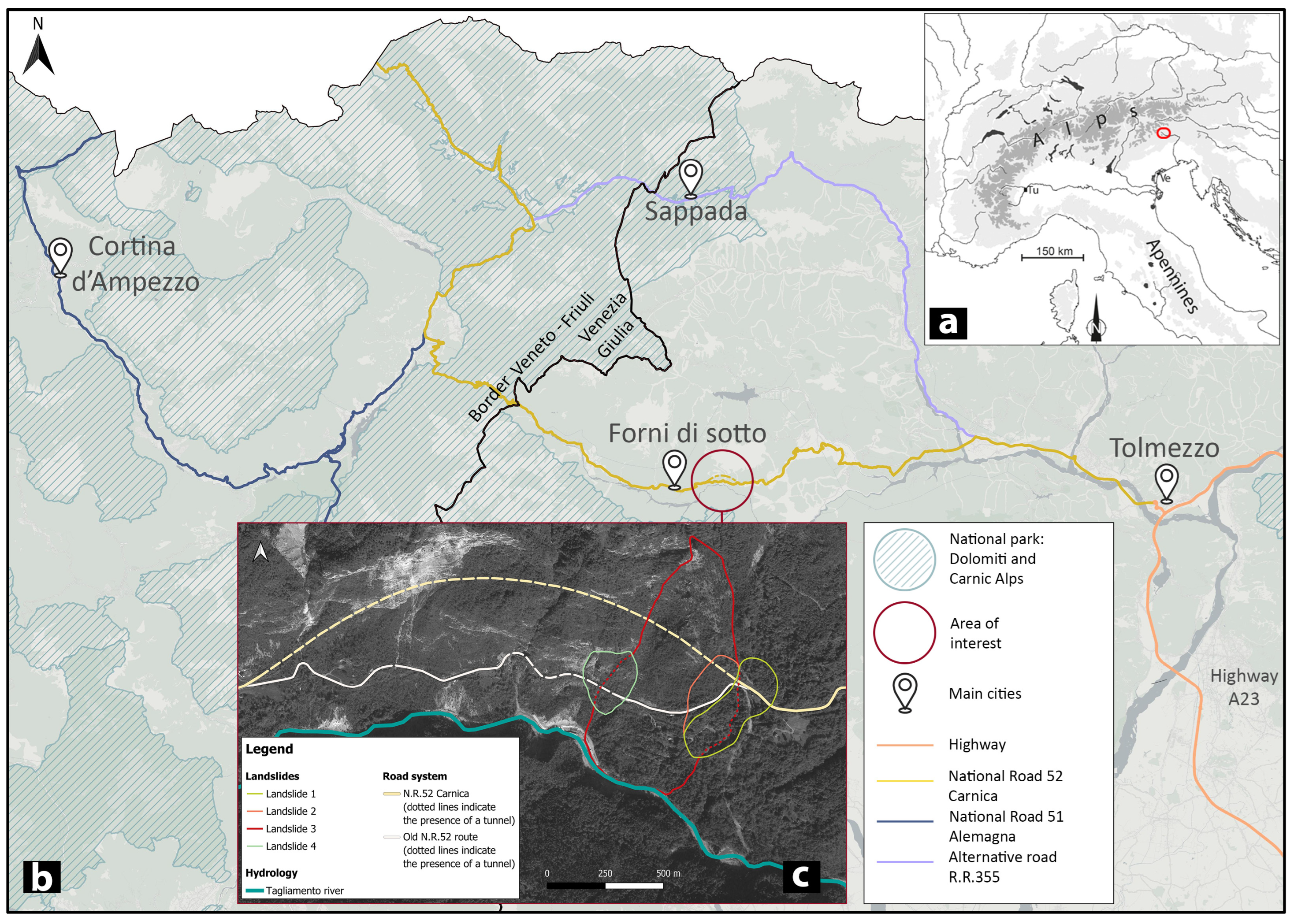
The study area is located in the Upper Tagliamento Valley in the Friuli Venezia Giulia (FVG) Region, in the municipality of Forni di Sotto. This region stands out as one of the rainiest in Europe. Historical data collected from 1961 to 2000 revealed an annual mean precipitation of 1721 mm, fluctuating between 1229 and 2370 mm [
10]. In the subsequent years, from 2004 to 2022, the Forni di Sopra station documented an annual average precipitation of 1575 mm, with a minimum of 1108 mm and a maximum of 2228 mm, indicating significant variance. In relation to the entire Upper Tagliamento valley, the Passo della Morte section is extremely narrow, creating a steep gorge above the Tagliamento River. For this reason, there is no alternative route other than the National Road 52 Carnica that connects the Upper Friuli Venezia Giulia Region with the dolomitic area of Cadore (
Figure 1). In the event of traffic disruption caused by landslides, no alternative routes exist. In fact, a detour exceeding two hours would be necessary to circumvent the closed road.
In this context, a 2220 m long road tunnel, known as the San Lorenzo tunnel, was built in 1994 to avoid a winding tract of the old N.R. 52 route hanging along a rocky cliff and prone to rock falls, shallow landslides, and snow avalanches (i.e., Landslide 4 in
Figure 1c). However, in 1996, the tunnel suffered structural damage during a heavy rainfall event, triggering the reactivation of a pre-existing large-scale landslide (Landslide 3 in
Figure 1c). Subsequently, in 2006, a new tunnel was constructed using independent tunnel segments to absorb the strain induced by the constant, albeit small, displacement induced by the landslide. At the same time, in order to dissipate the pressure exerted by groundwater, a T-shaped drainage tunnel was constructed beneath the road tunnel. All geological data derived from the tunnel excavation, along with further 40 boreholes, were used to formulate the initial engineering geological model of the slope [
11], which has since then been subjected to periodic review and updates incorporating a wide range of field data.
The study area of Passo Della Morte is situated within the Alpi Tolmezzine Occidentali—Bivera group, according to the International Standardized Mountain Subdivision of the Alps (ISMSA) [
12]. Previous research carried out in the area [
13,
14,
15,
16,
17,
18,
19,
20,
21,
22,
23,
24] has contributed to understanding the stratigraphic and structural setting of this sector of the Carnic Alps. Notably, the area is marked by regional tectonic lines, including the Sauris thrust front to the north and the Alto Tagliamento line to the south. The Carnic Alps exhibit a North–South direction compressional thrust resulting from the Alpine orogenesis. Additionally, a series of NE-SW direction strike–slip faults associated with the principal stress are recognizable in the area [
19].
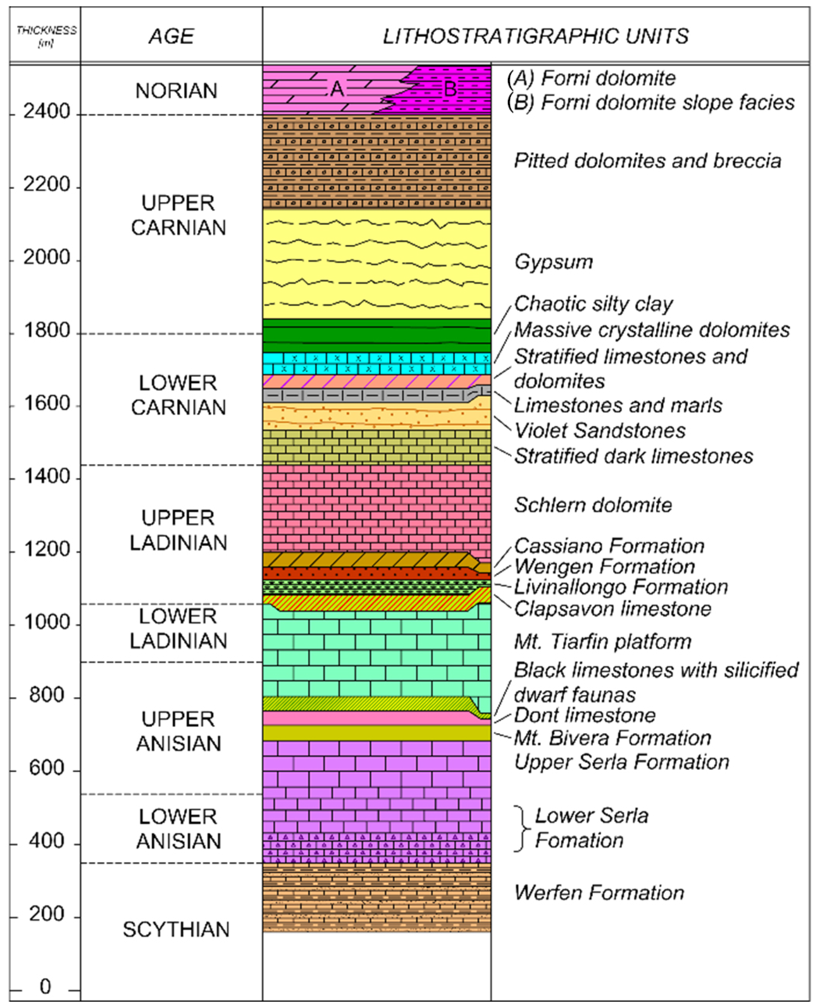
A fundamental geological study of the Bivera area was published by Pisa [
22]. Integrating this study with data derived from several boreholes, the stratigraphic column representative of the Passo della Morte area was developed (
Figure 2). Here are found the Schlern Dolomite outcrops, a massive rock unit dating back to the Upper Ladinian (Triassic period). This unit includes dolomite, dolomitic limestone, and calcareous dolomite. The stratified dark limestone alternates micritic limestone with levels ranging between 0.1 and 1 m and dark marls up to 0.2 m thick. It covers the Schlern dolomitic platform, and it can be observed along the old N.R.52 route, where its thickness ranges between 200 and 300 m.
Stratified limestone and dolomite units date back to the Carnian period. These units are a succession of dolomite, limestone and calcarenite with thin gray marly intercalations for a total thickness of 25 m. The massive crystalline dolomite is a 10 m thick layer of compact light grey doloarenite on the top of the Carnian stratified limestone and dolomite units. The chaotic silty clay is a characteristic reddish claystone with arenaceous layers less than 1 m thick. The color is the distinctive element of this Carnian age unit. Some intercalations up to 10 cm of massive whitish-gray marly dolomite can be found. The gypsum is an Upper Carnian unit with clayey dark layers or inclusions. Pitted Dolomite is an Upper Carnian unit too, made by gray marly dolomite and light-tone dolomite and dolomitic marl. The Forni Dolomite consists of dolomite and dark marly dolomite in thin layers up to one decimeter thick, dating back to the Noric age. Organic material can be detected in the marly levels characterizing the unit. Locally, Quaternary deposits cover the Triassic basement. The Quaternary units result from complex regional geomorphological processes dating back to the Pleistocene and the Holocene. The Quaternary deposits mapped in the Passo della Morte area include alluvial deposits, glacial moraines, polygenic conglomerates, slope debris and the chaotic deposits of a late-glacial landslide, i.e., the Marocca di Sacrovint, characterized by various degrees of cementation. The term “marocche”, in the Alpine geological literature [
25], refers to large-scale landslides, originally supposed to be of an early post-glacial age, frequently resulting in valley damming and in the subsequent deposition of lacustrine and fluvio-lacustrine sediments. In this area, a similar phenomenon, of an estimated volume of 5 × 10
6 m
3 (
Figure 3), occurred around 9800 years ago, inducing the formation of a 6.5 km long lake with a perimeter of 19 km that lasted for approximately 2000 years [
26]. The presence of this lake promoted the formation of the Auza fan, where the settlement of Forni di Sotto has been established [
11].
As far as tectonics is concerned, the upper Tagliamento valley features the Sauris line, which is characterized by extensive conjugated East–West tectonic structures. This low-angle overthrust is characterized by Upper Ladinian and Carnian units (Schlern Dolomite and Stratified dark limestone) overlapping the most recent Upper Carnian units (Gypsum and Chaotic silty clay). The change in direction of the Sauris line at the Passo della Morte may be due to its intersection with a conjugated N–S directed strike fault system. Field mapping has allowed a detailed geological and geomorphological map to be drawn (
Figure 3).
The gradual re-balancing of the upper Tagliamento valley slopes after the Last Glacial Maximum (LGM) has represented a crucial geomorphologic factor driving slope instability. During the Pleistocene glaciations, the ice in the Tagliamento basin reached an altitude of up to 1600 m above sea level, with only a few peaks emerging from the ice cap, namely Mount Tinisa and Mount Bivera. The area between Passo della Morte and Cima Corso has experienced slope instabilities, resulting in the Tagliamento river changing its course from a westward direction to a southward flow [
27]. The main cause of these instabilities is believed to be the removal of support as a consequence of glacier retreat and down-wasting [
1].
The landslides forming the Passo della Morte landslide system (Landslides 1–4 in
Figure 1) are part of a larger, possibly late-glacial Deep-seated Gravitational Slope Deformation (DsGSD in
Figure 4) and can thus be considered as secondary slope instability processes. More in detail, Landslide 3 is the most relevant slope instability process in terms of state of activity, area, depth and volume: it can be described as an active rock-block slide, with an area of 450,000 square meters, a sliding surface depth of approximately 60 m deep and a volume of 24 × 10
6 m
3 (
Figure 4). The slope movements started with a subvertical displacement of a DsGSD conditioned by the tectonic lineaments conjugated to the main overthrust lineaments (post Last Glacial Maximum) and has then evolved in a rock-block slide that is currently moving in a south–southwest direction (
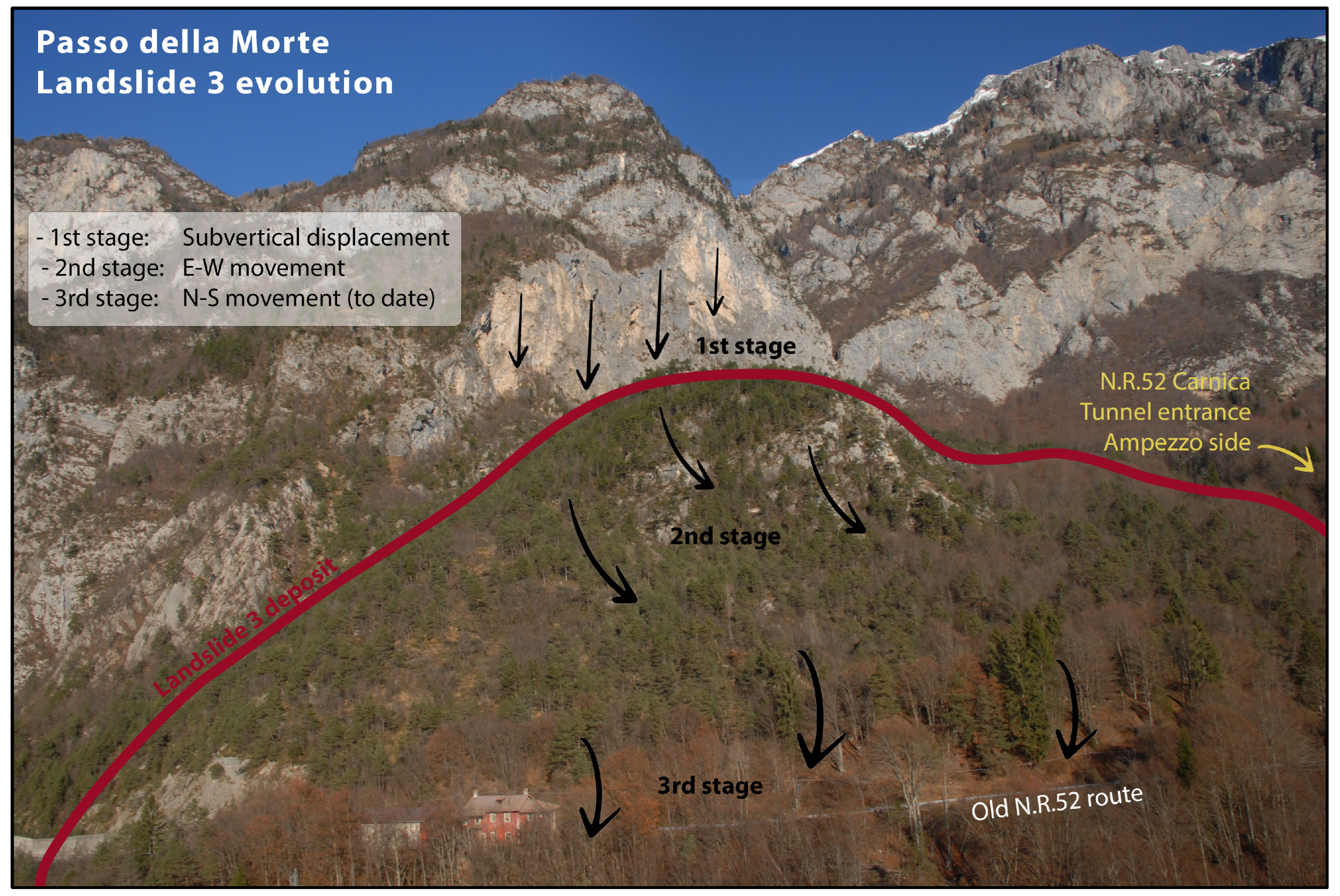
Figure 5).
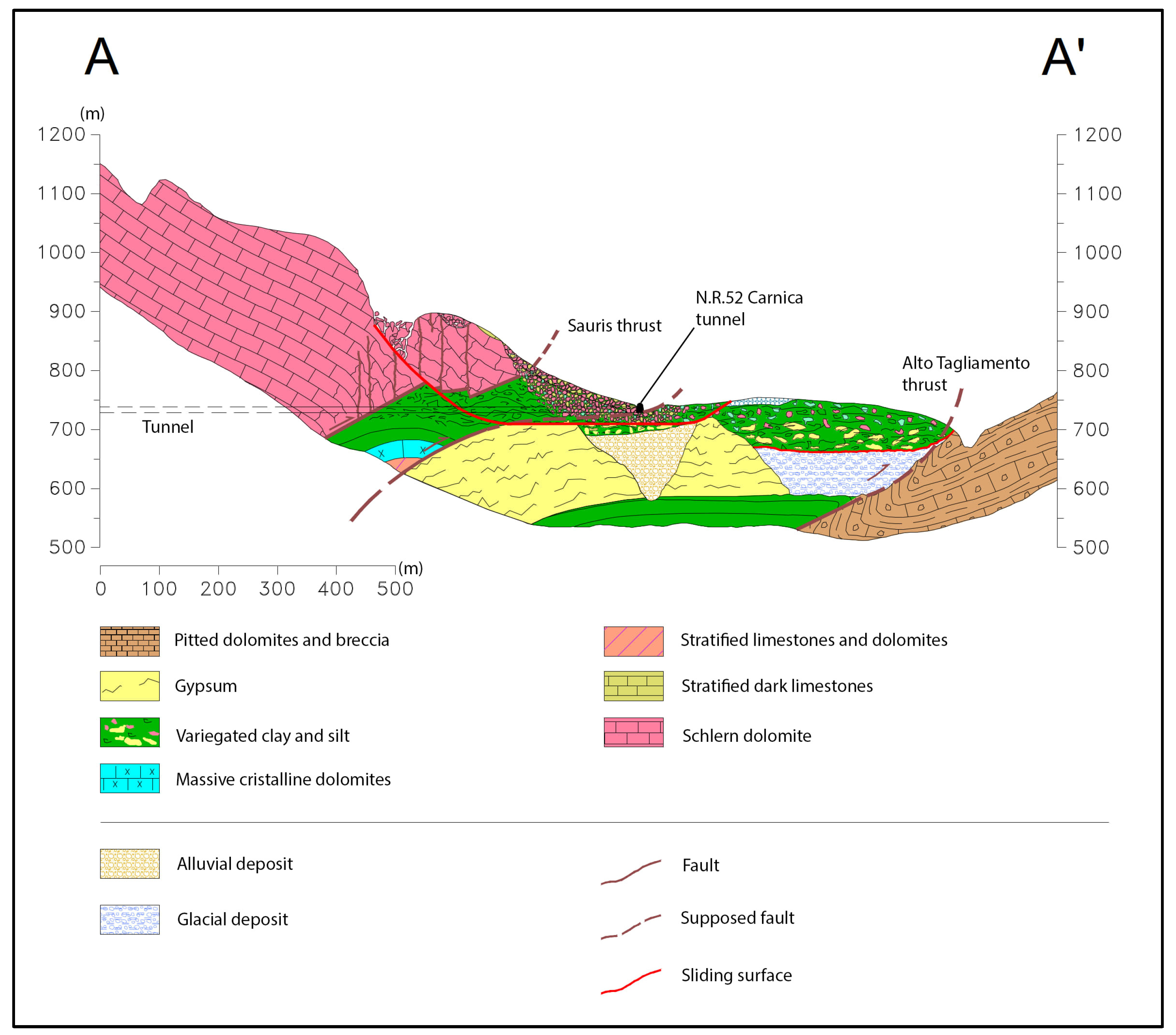
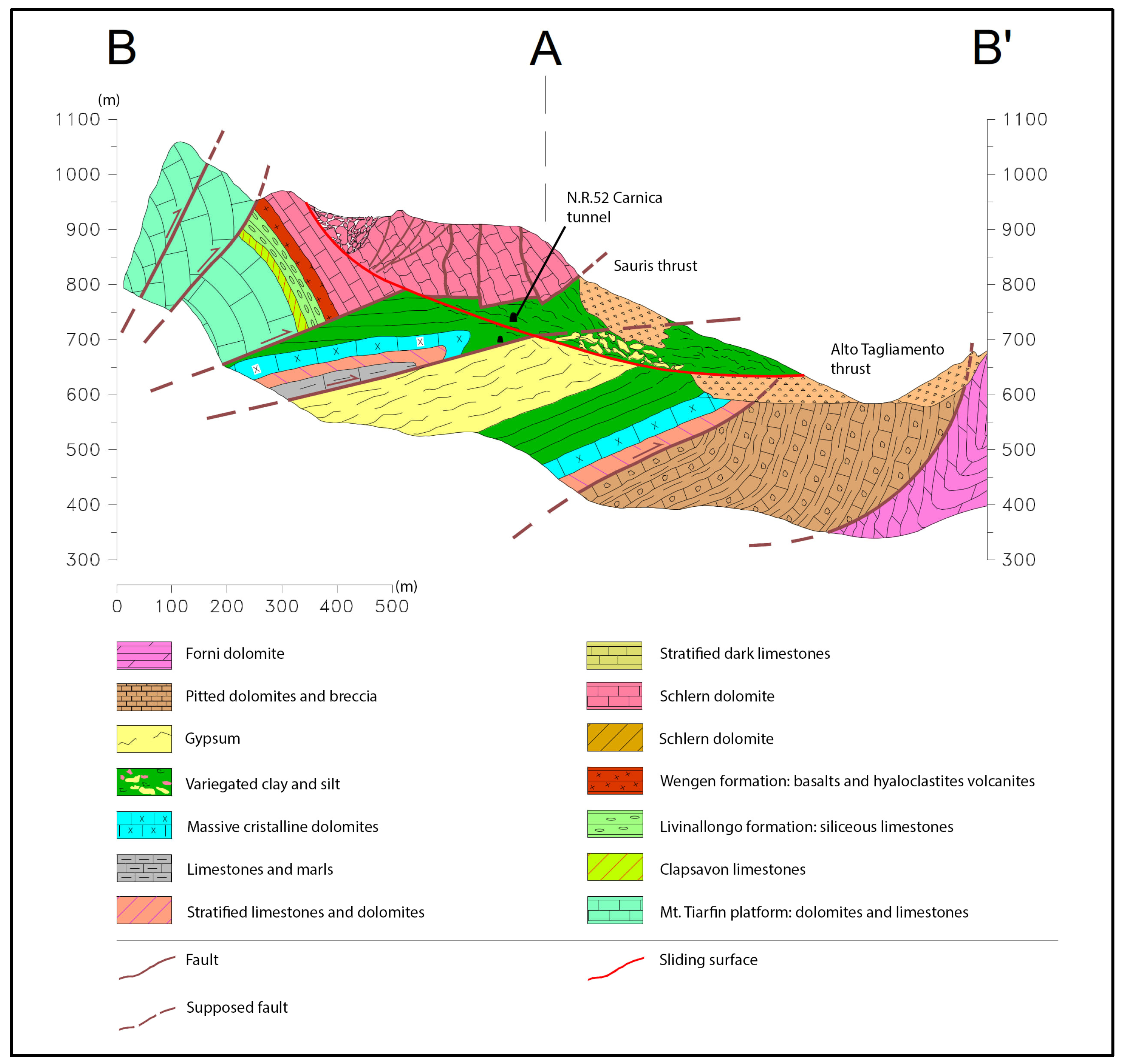
To highlight the spatial relationship between landslide bodies and road infrastructures, several geological cross-sections were initially drawn, two of which are reported hereafter [
11]. The geological section AA’ runs in the direction of the tunnel, whereas BB’ follows the slope. AA’ (
Figure 1) highlights a further tectonic dislocation, which is responsible for the intermingling of gypsum and clay-rich units. The so-called Upper Tagliamento line is a regional south-verging structure developed in an East–West direction. At the site scale, the Upper Tagliamento line brings the Schlern dolomite into contact with the more recent units. Both geological cross-sections AA’ and BB’ reveal that the Tagliamento riverbed is almost aligned with this overthrust. Additionally, a series of minor tectonic lineaments detected in the Passo della Morte area are developing in a North–South direction. Two of them are located in the southern part of the Tagliamento Valley (
Figure 3).
Both sections AA’ (
Figure 6) and BB’ (
Figure 7) illustrate the scarp, the body and the sliding surface of Landslide 3. The landslide body consists of a highly fractured, karstified and permeable dolomitic rock mass overlying plastic and less permeable clay-rich units.
3. Methodology: The 3M Approach: Monitoring, Modelling and Mitigation of Landslide Hazard along Critical Infrastructures
Monitoring, modelling and mitigation of landslide hazard is a circular process—ever updating as more information and analysis are gathered. From a first monitoring campaign, it is possible to collect data to produce a first-attempt model of an unstable slope. Then, through Bayesian updating, data can be analyzed in order to quantify where the uncertainty is higher [
28]. Then, we can target a second field investigation in areas where uncertainty has been proven to be more impactful in terms of parameter variability. At the same time, in a context of limited economic resources, modelling can support the definition of incremental structural mitigation measures. Accordingly, the countermeasures can be implemented in sequence, checking their effectiveness through monitoring to assess when the required level of acceptable residual risk is reached. Following this approach, uncertainty becomes an opportunity rather than a weakness. By introducing the concreteness of uncertainty, the design of countermeasure works for landslide risk mitigation becomes an iterative process with explicit levels of reliability associated with their economic and environmental impacts, which is crucial to inform decision makers. For example, following the same methodology, an innovative mitigation strategy has been implemented for Landslide 1–2 at Passo della Morte, where the modelling of the effectiveness of the countermeasure was based solely on the monitoring data [
29,
30].
In the Passo della Morte area, an initial monitoring system was set up in the aftermath of the 1996 event, when tunnel construction had to be halted due to slope movements after heavy rainfall events. During the 1990s, the significance of observational methods and monitoring had yet to be fully incorporated into design and construction processes. The investigations at that time primarily focused on resuming tunnel construction without a comprehensive understanding of the phenomenon at the slope scale and in the framework of the geomorphological evolution of the area. Concurrently, the Italian National Research Council (CNR) initiated a site-customized monitoring plan. The CNR monitoring system has been expanded yearly ever since, to achieve redundancy and ensure a reliable dataset during critical events (
Figure 8). The monitoring strategy for the Passo della Morte landslide followed the 3M approach. This iterative process began with establishing a comprehensive monitoring network to collect data on landslide movements, hydrogeological variables, and other critical parameters.
The landslide monitoring system consists primarily of:
in-place inclinometers (IPI), strategically located to measure the depth and rate of landslide movements. Notably, inclinometer I16, which has been operational since 2012, provided valuable data on displacement patterns during severe weather events.
Piezometers deployed to monitor changes in groundwater within the slope in response to precipitation and snowmelt events.
A water collection system installed within the tunnel, along with a flow rate measurement device placed on a weir to monitor the spring discharge in response to precipitation and snowmelt events.
A GNSS (Global Navigation Satellite System) control network installed to monitor superficial slope movements on a periodical basis.
The initial system (operating with periodic GNSS measurements from 2012) effectively delineated the instability process but lacked the capability to assess displacement trends. To address this issue, in March 2023, eight permanent GNSS stations were installed (
Figure 8), with one station located in a stable area serving as the master station. This network provides continuous, near-real-time monitoring of surface deformations caused by landslide activity. The GNSS survey employs the static differential methodology, which is known for its high accuracy with error margins limited to the millimeter scale. In the field, dual-frequency receivers maintain continuous communication with the central master receiver (GNSS-MU in
Figure 8) to enable the transmission of error corrections. This setup ensures the provision of daily RINEX data. The dataset is subsequently post-processed with LEICA commercial software.
4. Results: The Updated Engineering Geological Model of the Passo della Morte Landslide Systems
The landslide bodies identified in the study area by geological survey have been defined in greater detail through continuous monitoring and data analysis.
Landslide 1–2 (2.1 × 10
6 m
3) impacted both the tunnel portal and a 200-m stretch of the National Road 52. This latter landslide unit 1–2 exhibits a complex style of activity characterized by rotational movement at the crown and translational sliding at the toe. It consists of two distinct scarps with converging toes, separated by the Rio Verde torrent, a small stream flowing in the vicinity of the eastern tunnel entrance. Both the tunnel and the old National Road 52 route cross the Rio Verde over a concrete box culvert. The damage observed in the culvert, the retaining walls along the road, and the road pavement is contributed to by the gradual and persistent movements of these landslides. During periods of intense meteorological events, the displacement of Landslide 1–2 undergoes surges marked by an increase in speed and induced damage [
29].
Landslide 3 has the greatest impact on the tunnel due to its depth and volume and their reciprocal position. It initiated as a consequence of the geological and structural context, namely because of the contrast in competence, strength and permeability between carbonate lithotypes and the underlying, more plastic clay-rich rock units, as well as by the loading exerted by the carbonates themselves. It was also driven by the tectonic lineaments and increased relief energy following the Last Glacial Maximum. The lack of lateral support due to the presence of ice likely influenced the onset of the slope instability phenomenon in the form of a DsGSDs/rock-block slide. Currently, the progressive dismemberment of the carbonatic portion of the landslide, due to the ongoing movements, facilitates the rapid infiltration of meteoric waters at depth, eventually reaching the clay-rich units where the main sliding surface is located.
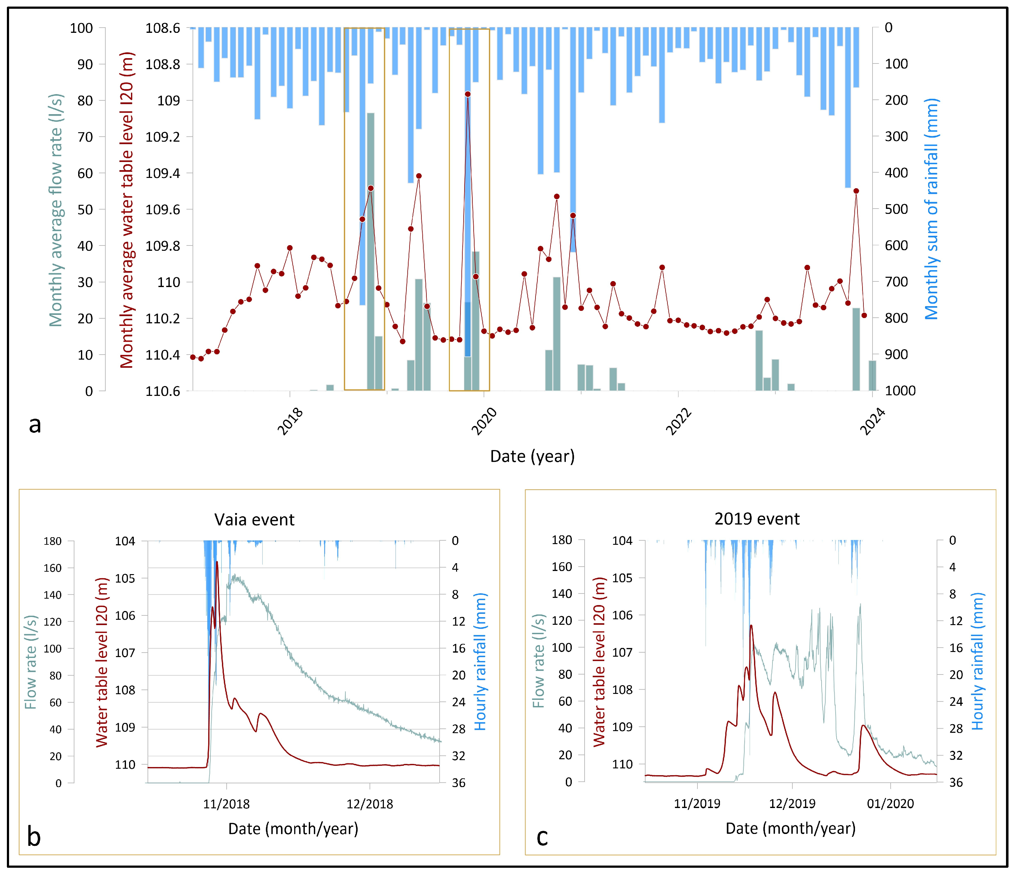
The increase in pore-water pressure affects the state of activity of the phenomenon, as suggested by data from several monitoring devices deployed in the area, such as in-place inclinometers (I16, I23, I24), several piezometers and a flowmeter.
Figure 9 illustrates the response to meteorological forcing in terms of water table and flow rate in the last seven years, and two significant events can be distinguished (i.e., 2018 Vaia and 2019 events). The trends provide valuable insights into the hydrogeological dynamics, highlighting the direct impact of meteorological events on groundwater flow and their implications for landslide movement and infrastructure integrity.
Monitoring has also facilitated a more comprehensive definition of the kinematics of the landslides. The geotechnical instrumentations have enabled the precise delineation of the sliding surface in three dimensions and the assessment of variations in the groundwater table in response to meteorological events. The continuous dataset provided by in-place inclinometers (IPIs) supports the correlation of landslide movement along the sliding surface with intense precipitation events, seasonal melting of snow cover and groundwater flow rate from the rock mass. The inclinometer I16, installed in 2012 and consistently operational, emerges as emblematic, effectively delineating the displacement along the sliding surface situated at a depth of −59 m below the ground level. Thanks to this IPI, the behavior of the Landslide 3 was documented during severe weather events, including occurrences in 2014, Vaia in 2018, November 2019, December 2020 and November 2023 (
Figure 10).
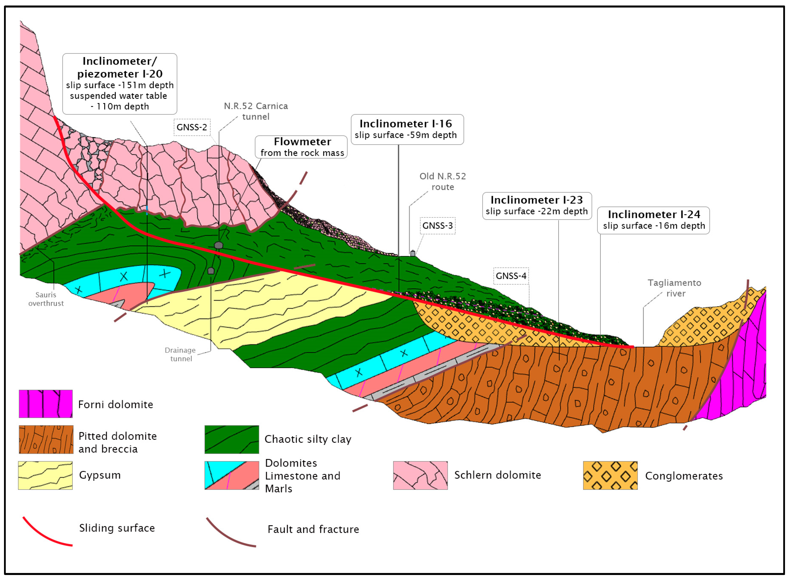
The implementation of new boreholes downslope (I23 and I24), previously hindered by logistical challenges, combined with instrumental measurements, has enabled us to redefine the perimeter of the Passo della Morte Landslide 3.
The extent at the toe is delineated by the red line in
Figure 8. Both inclinometers recorded displacements of almost identical magnitude in the months between measurements, stabilizing at 4 cm for I-23 and 3 cm for I-24. These displacement rates are consistent with observations derived from GNSS measurements ranging from the early 2000s to the present. The sliding surface is most visible at a depth of 25.5/27.5 m for I-23 and 15.5/17.5 m for I-24 (
Figure 11). Based on a thorough analysis of on-site instrumentation data and a sound geological knowledge, the new engineering geological section in
Figure 11 has been drawn. It is divided into three segments corresponding to the inferred directions of movement across the upper, middle, and lower regions involved in the landslide evolution (
Figure 8). These segments are oriented at 140°, 190°, and 220° North, from the top to the bottom. The segment begins just above borehole I20 upslope, through inclinometer I16, downslope towards inclinometers I23 and I24.
Furthermore, multi-year monitoring has revealed a distinctive pattern of acceleration in Landslide 3 during the initial two days following extreme weather events. This immediate response is then followed by a slower, inertia-driven movement due to the landslide’s massive volume, which continues to displace over several days or weeks (
Figure 10). The understanding of Landslide 3 dynamics is valuable for predicting its impact on the tunnel infrastructure.
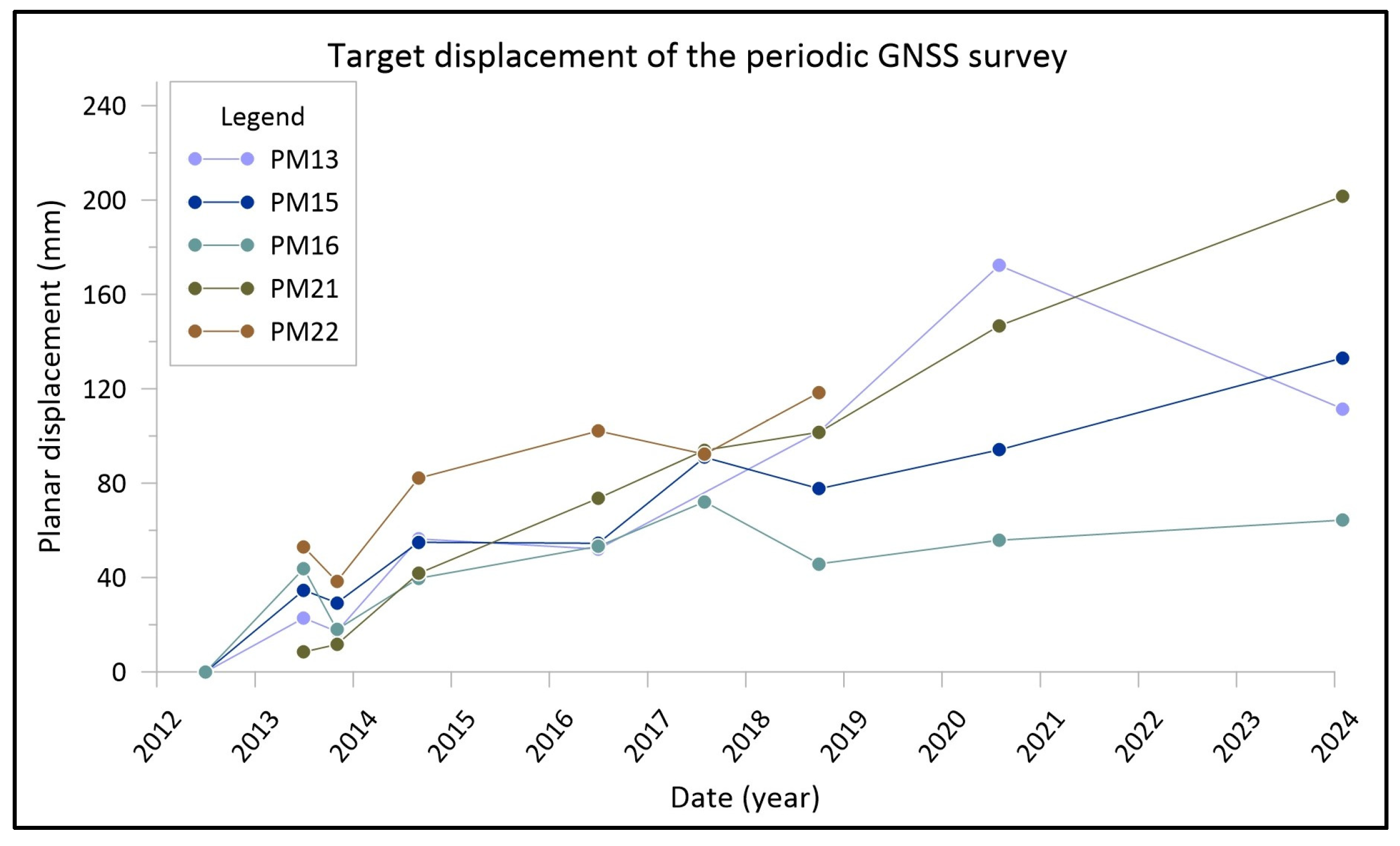
Based on the refinement of the sliding surface position and geometry, it can be confirmed that the landslide moves as a rock-block slide following the Hungr et al. (2014) classification [
31]. This conclusion is also strongly supported by systematic GNSS measurements (
Figure 12).
The periodic measurements validate the block-slide-type movement of the landslide and provide quantitative evidence of its displacement pattern. To date, the continuous GNSS monitoring network dataset is still undergoing validation and will enable the measurement of displacements and the establishment of reliable alert thresholds [
32].
5. Conclusions
Managing landslide hazards in complex geological settings demands a multifaceted and adaptive approach. The Passo della Morte area, traversed by a strategic road infrastructure threatened by the unremitting movements of several slope instabilities, has been selected to exemplify the iterative 3M approach: Monitoring, Modelling, and Mitigation, continually updating on the basis of new techniques and data results.
The geological, structural, and geomorphological settings predispose the area to slope instability. The stratigraphic succession consists of brittle dolomites overlying ductile clay shale as a consequence of regional tectonic activity. The fractured and karstified rock mass facilitates the rapid infiltration of meteoric water, inducing large and deep-seated mass movements that impact the road tunnel.
The study incorporates a thorough literature review, over 20 years of site investigations with 40 borehole logs and a comprehensive monitoring network. Extensive monitoring, both in space and time, proves fundamental for establishing a large and continuous database elevating the comprehension of the engineering geological model. Additionally, the monitoring system provides data on the effectiveness of implemented structural mitigation measures. These, in turn, have been designed based on the engineering geological model and facilitate the design of additional countermeasures if previously implemented ones would prove to be inadequate.
The 3M approach allows inferences to be made about the updated detailed engineering–geological section presented herein. We have been able to refine the landslide model, offering a more accurate representation of geological conditions. Specifically, this methodology enabled a precise redefinition of the sliding surface of Landslide 3, improving our understanding of the landslide kinematics and its behavior in response to meteorological events, thereby facilitating a proactive approach to landslide management. A mitigation strategy for landslide 3 is currently underway based on our updated findings on the dynamics of the landslide. The drainage tunnel will be extended according to the new engineering geological cross-section and monitoring results to improve the performance of the adit in mitigating displacements. The effectiveness of this improvement will be assessed by the same monitoring system in a continuous cycle of monitoring, modeling, and mitigation.
The insights gained from the Passo della Morte case study provide a valuable framework for addressing landslide hazards in similar geological settings worldwide. Moreover, the successful implementation of the 3M approach in this context underscores the potential for its application in other regions facing comparable challenges.


