Cousins, Siblings and Twins: A Review of the Geological Model’s Place in the Digital Mine


CSIRO Energy, PO Box 883, Kenmore, Brisbane 4069, Australia
*
Author to whom correspondence should be addressed.
Resources 2020, 9(3), 24; https://doi.org/10.3390/resources9030024
Submission received: 5 December 2019
/
Revised: 18 February 2020
/
Accepted: 27 February 2020
/
Published: 4 March 2020
(This article belongs to the Special Issue Advances in Mining Technology: The Digital Mine)
Abstract
:Digital mining is a broad term describing the enhancement of the physical mining method through the use of digital models, simulations, analytics, controls and associated feedbacks. Mining optimisation will be improved through increased digitisation and real-time interactions via a “digital twin”, however digitisation of the rock mass component of this system remains problematic. While engineered systems can be digitally twinned, natural systems containing inherent uncertainties present challenges, especially where human-intensive procedures are required. This is further complicated, since the mining system is designed not only to interact with, but to substantially and continually alter its surrounding environment. Considering digital twin requirements and geological modelling capabilities, we assess the potential for a mine’s synchronised digital twin to encompass the complex, uncertain, geological domain within which it interacts. We find that current geological (and indeed hydro-geological) models and simulations would support digitisation that could be considered to provide, at best, a digitised ‘cousin’. Based on this assessment, the digital twin’s value for medium term forecasting of mining operations may be limited and we discuss technological advancements that can mitigate this.
1. Introduction
Digital mining is a broad term describing the enhancement of the physical mining method using digital models, simulations, analytics, controls and feedbacks. While much has been written on the value of the digital twin (e.g., [1,2,3,4]) little has been said on the digital twin’s interaction with the non-engineered space, or the natural environment within which it sits. Often the twin of an engineered system may only need to consider a few natural, external conditions or environmental parameters such as temperature, wind and moisture, each of which may be predictable in a statistical sense, directly observable or measurable. Additionally, the environmental aspects of a digital twin can also be implemented because the engineered system that has been twinned is typically not designed to dramatically change the natural environment upon which it operates and with which it interacts.
We define the minimum criterion of a digital twin to be a synchronised, real-time pairing of a virtual and a physical domain that can predict its own behaviour and inform decision makers with sufficient precision to ensure adequate productivity and safety in real time. To optimise the functioning of a digital twin in a complex environment, an equally accurate digital twin of that environment would be ideal. We define mining as the process of extracting geological materials from the Earth. We hypothesise that in the case of a mining system, which comprises coupled engineered and natural systems, this is problematic. Therefore, it is important to explore the extent to which the natural system can be replicated in a digital domain. The purpose of this work is to explore to what extent a digitised in situ geological environment can match reality, to determine whether it can be described as a digital twin. We explore how effectively the digitised in situ geological environment can be implemented to support a digital twin for optimal operation of the physical mining system.
Background
In 2010, Shafto et al. [5] described the term digital twin as:
‘…an integrated multi-physics, multiscale simulation of a vehicle or system … continuously forecasts the health of the vehicle/system, the remaining useful life and the probability of mission success.’
Figure 1 presents a schematic of the digital twin concept that considers the pair (the physical and the virtual systems) to be twinned.
Formerly, digital twins were descriptive, static 3-D computer-aided design (CAD) objects. In 2002, an early version of a digital twin was presented as the Product Lifecycle Management (PLM, later called the Mirrored Spaces Model, MSM) consisting of a virtual system containing all the information about the physical system (University of Michigan). The twins were dynamically updated and linked throughout an entire lifecycle [6]. The concept of having a (partially digital) twin of an engineered system was later adopted for the Apollo program when NASA built multiple space vehicles to allow one on Earth to be used as a mirror of the one sent into space, and to provide for training and simulations [1].
More recently, digital twins have become actionable, meaning that we can simulate physical forces over time to influence and determine the model’s behaviour [6]. As simulations have become more advanced, their connection between the virtual and physical form has allowed them to become real-time representations that can be used to forecast conditions and provide predictive capabilities.
With respect to the Shafto et al. definition, continual forecasting would naturally require a direct connection with the physical object in real time. Glaessegen and Stargel’s definition [7] from later work from the same team is also widely cited:
“…digital twin means an integrated multiphysics, multiscale, probabilistic simulation of a complex product, which functions to mirror the life of its corresponding twin’.
For clarity, here we continue to refer to system rather than a product.
In summary, and more recently, a digital twin has been defined by Grieves and Vickers (p. 94) [6] as
‘A set of virtual information constructs that fully describes a potential or actual physical manufactured product from the micro atomic level to the macro geometrical level. At its optimum, any information that could be obtained from inspecting a physical manufactured product can be obtained from its Digital Twin.’
A digital twin may be of a single part of a machine or system, through to an entire machine or entire plant, or may be built to represent processes and methodologies that take place in business that collate large amounts of data. The key word in the definition is ‘manufactured’, suggesting that this only refers to the built environment and its engineered components.
The mining system is defined herein as the collection of natural and engineered subsystems or components associated with the exploration, design, operation and closure stages of mining (and not processing of the extracted rock). The focus of this paper is the operational stage, specifically removal of rock from the in situ rock mass. The natural system of relevance here comprises the geology and hydrogeology system with which the engineered components interact. A model of these natural subsystems will hereafter be referred to as the non-engineered system. Geological and hydrogeological models are derived from a relatively small amount (volumetrically) of actual observations, prior knowledge of geological processes and interpretation and interpolation, also requiring human-intensive interactions for validation and quality assurance.
Interruptions to mining production and problems such as unplanned dilution and unforeseen hazards are often a result of the mine operating within ‘approximately-known’ geological conditions [8,9]. It is clear from this, therefore, that a mining digital twin will function better if the geological domain, and its digitised version, respectively, are closely connected. While a digitised geological domain does not replicate reality, a well-informed, frequently updated model would provide the mine’s digital twin with the ability to consider more information as it becomes known to inform potential operating parameters.
A digital twin of a mining system should therefore provide a decision making tool based on modelling and simulations that monitor, predict and manage operations to ensure adequate productivity and safety in real time. This would necessarily involve analysing past and current performance and assessing and predicting future scenarios. Additionally, models and simulations are commonly designed to solve one or just few specific problems, so an array of such technologies would be required to develop a virtual representation of the physical domain. In a report by EY [10], it is suggested that digital twins are likely to be of value at most nodes in the mining chain although exploration is not cited as one of these. This may be due to the uncertain nature of the geological modelling of the in situ rock mass. Nevertheless, digital twins of exploration equipment such as drilling, and assay operations may potentially be twinned if of value to the process. At mine sites, digital twins are being used to simulate the processing plant, a man-made, engineered operation, such as at Koodaideri, Western Australia [11]. Anglo American is using a digital twin for optimising the haulage fleet at Los Broncos, Chile [10]. Lithological, geochemical and geophysical information of any rock or mineral resources used to produce engineered components would be vital for informing on their reliability for an engineered digital twin. Although such information might be derived from a geological model, due to the limitations of the geological model (namely sampling limitations and rock mass homogeneity) it would be more likely obtained from micrometre-scale or laboratory-performed analyses that in turn could inform the geological model.
Here we explore the requirements of a digital twin for the mining system and the extent to which such a system can be expected to perform when it is interacting with the uncertain, complex and likely suboptimal digitised geological model. Further we examine potential conduits that may connect the two.
2. Materials and Methods
Our hypothesis is that although other components of the digital mine may perform with high reliability, the digital twin of the natural environment (being the geological and hydrogeological system) will be suboptimal, potentially hampering the overall performance of the digital mine.
If this hypothesis is proven, we must then assess the extent to which a virtual twin of the physical geological system (the geological model) is possible, how the interface between the two may work, how digitisation of the geological system may be improved and its value to the digital twin.
For this process,
- We explore the potential reasons for needing a digital twin to confirm it is necessary in a mining domain;
- We then compare geological modelling capabilities with digital twin criteria and determine whether a geological model can become a digital twin;
- Finally, we explore potential technological advances that may improve the geological non-twin.
3. Analysis and Results
3.1. Understanding Digital Twins and Confirming Their Necessity in the Mining Domain
In the case of mining, a digital twin consists of the physical system, the virtual system and a two-way link between them allowing the system to be informed and synchronised, allowing it to adjust its behaviour as required [7]. The two-way link, referred to as the unified repository [12] is constantly maintained with both the physical and virtual systems, receiving and sending information in both directions. Systems are known to behave predictably or unpredictably [6] affecting the productivity, safety and environmental responsibility of the mining operation. Real-time connectivity (in actual-time, reporting and responding to sensors ‘on the fly’) through the unified repository for mining applications requires subsecond two-way transfer of information. Connectivity between the incoming data and the geological model should also be fast, if not in real-time, to facilitate prompt interpretation and incorporation of the information. This two-way link allows predictable behaviour to be mapped and unpredicted behaviour to be monitored, further informing the decision maker.
While it is possible to measure, analyse, control and predict the components and interactions within an engineered, complex system, its sophistication and size can cause it to be unreliable and may fail to produce desired results, often without warning [6], jeopardising mining productivity, safety and environmental security. While unpredicted behaviour, may, by good fortune lead to desirable outcomes, it may also cause undesirable minor, dramatic or even catastrophic outcomes. Minor issues in a complex system can also cascade into a major failure [6]. Therefore, to optimise productivity and safety for people and the environment, unpredicted behaviour requires resolution. Digital twins can support this optimisation, particularly in the increasingly autonomous mine, providing design, analysis and forecast of mining performance against this triple bottom line.
Geological environment aside for the time being, a complex mining system that is measurable and predictable can be designed, monitored and managed to avoid the least desirable behaviour to occur. For example, excess wear and tear on equipment may be undetected, cables may be broken or faulty, equipment may be unsuited to the task, each leading to major failure that can have severe consequences. Mining system automation provides a means to achieving a safer, more productive mine [13]. Being able to remotely ‘see’ or operate every asset within the mining space is becoming more possible. Challenges include sensing for the location and state of equipment and mineralogy, architecture to improve communications safety and performance, automation connectivity between multiple machines, and integration of the human-experience with feedback mechanisms and immersive visualisation [13].
An additional challenge, however, is the mine’s interaction with its environment, with unexpected events affecting the resulting behaviour. As engineering solutions and management processes are developed and implemented to optimise production whilst maintaining safe operations, resulting behaviour should become more predictable. Other interruptive and problematic behaviour can occur within mining systems as a result of interaction with unexpected conditions in the geological environment. We discuss this further below.
Not only can complex systems such as those in mining be difficult to predict, further problems can arise from human interaction, where people may be (deliberately or accidentally) inconsistent or they may not make suitable sense of inputs and outputs [6]. Further, some parts of the complex system heavily rely on expert elicitation and involvement such as for quality assurance or validation. We argue that unexpected, unintended behaviour of natural systems that are external to the engineered system, and in particular the geological system, can influence the engineered system. As much information as possible of the natural, interacting, physical system, and indeed a digitised version of it, would provide a means to avoiding or reducing potential unpredicted/undesired behaviour.
3.2. Assessment of Current Geological Modelling Capabilities against Digital Twin Criteria
Grieves and Vickers (p. 94, [6]) define a digital twin as requiring a set of virtual information that fully describes a physical, manufactured product. It is clear a geological system is not manufactured, and the natural rock mass necessitates an appraisal of geological sampling and modelling capabilities compared with those of an engineering model to determine the capacity for it to be twinned.
The rock mass is often described as Discontinuous, Inhomogeneous, Anisotropic, and Not Elastic (DIANE). This presents particular challenges in sampling and modelling/simulation when compared to engineered materials. For example, characterisation of rock mass discontinuities (orientation, persistence, connectivity, aperture) is critical for simulation of mine processes including slope design and stability, depressurisation and dewatering, drill and blast optimisation and rock mass fragmentation.
Data used to build a geological model (such as logs, remote sensing, geophysical surveys, geochemical data) is obtained in a range of spatial resolutions that require varying degrees of processing and interpretation. Interpretation uncertainties and inconsistencies will exist in interval data, trend data, logs and resulting maps and cross-sections in three dimensions [14]. The lack of precision in subsurface knowledge and sources of uncertainty in the geological model can be considered from what has been used to develop the geological model. To improve precision and reduce uncertainty, new methods are being developed, but while a key aim is to analyse, quantify and communicate uncertainties in a geological model, they do not yet remove those uncertainties sufficiently to develop a ‘twin’ of reality. That is not to say that efforts are not being made to improve the models being used.
Geoscientific data frequently has irregularities in distribution and number of observations, in addition to noise. Such issues can be approached to improve the data-value for modelling, using multivariate analysis including self-organising maps (SOM) [15] and machine learning [16] to predict missing values or interpolate where inconsistencies occur. SOM is also useful for combining disparate datasets including magnetic susceptibility and gravity data for example [15].
Limitations with current, state-of-the-art geological modelling capabilities have both cognitive and technological roots. The former is well described in the literature and stems from the reliance of the geological and geotechnical engineering discipline on ‘expert judgement’, particularly for addressing ‘epistemic’ or model uncertainty [17]. The latter is also well recognised and stems from the complexity of the rock mass in terms of structure, composition, coupled interactions and time dependency and the inability of current computational methods to be reliable and practical.
Numerical modelling methods have advanced substantially [18], however, they are currently limited in terms of model dimension, multi-physics capabilities and dynamic processes. For management of stochastic or ‘aleatoric’ uncertainty, stochastic simulation methods have advanced considerably in the geosciences, particularly in the field of geostatistics. However, these methods struggle to reliably generate and quantify likelihood of low probability but high consequence realisations, especially associated with rock mass structural conditions, and therefore the usefulness of such approaches for forecasting mining system behaviour falls well short of a digital twin’s requirements. Benndorf and Buxton [19], discussed discontinuous- to near-real-time reserve reconciliation that updates the model, by processing and integrating information from sensors, quantifying prior resource model knowledge and updating it in near real-time. Improving the resolution of geological information will provide more realistic model scenarios, particularly important for geotechnical challenges and improving stability of underground roofs and walls. Techniques are currently being developed for example to detect faults with less than 1m throw [20,21]. Presence of minerals using remotely sensed data hyperspectral data is used widely for geological characterisation [22]. Uncertainty inherent in certain characteristics of underground mines exhibit risk profiles requiring evaluation methods that evaluate a range of strategies to help the decision making process [23]. Such methods aim to reduce risk relating to known uncertainties, seek more information about the model itself, and improve it as quickly as possible, acknowledging that the model is not close enough to reality to be described as a ‘twin’ while as inherent uncertainties remain.
Geological and hydrogeological models inform the mine design and operations. The models are, in turn, informed by direct and indirect observations, augmented by ‘synthetic’ data not supported by direct observations, but by interpolation between them [24]. The geotechnical model (including lithology, structure, rock mass character and hydrogeology [25]) in combination with the resource model, is used to optimise mine design. The geotechnical model is also developed through a process of direct observations (exploration and blast drill holes, core, down-hole geophysics), indirect observations (cross-hole geophysics), interpolation between those observations and from neighbouring datasets and interpretation and prediction in addition to stochastic simulation to manage uncertainty. The moment the excavation of rock begins, the model is being tested and validated. As new data and information become available, updates to the geological and geotechnical models can provide opportunity to improve or adjust production. In practice, models are typically updated infrequently.
For the virtual system of a digital twin to be more than a digital model or simulation, it must be informed by real-time sensors and fed information about its surrounding environment. Equally, for a digital twin to be valid, it must be synchronised, with high levels of automation for information sharing through the unified repository, holistically testing and reporting on the system. Mining operations may use in-house, external or a combination of expertise and capabilities for data-acquisition, quality assurance/quality control (QA/QC), model construction, simulation and interpretation. In the authors’ experience, the degree of human interaction required is high (particularly for the QA/QC and model construction and interpretation stages) and the associated latency between data acquisition and interpretation of model results is often the order of weeks to months. This falls well short of the requirements for a digital twin.
That said, a ‘system’ can be a subset of a larger system, so digital twins of part of an entire mining system would be effective. Developing a mine over its life requires an iterative process involving improvements in geological knowledge (rock type, its characteristics, its boundaries, its structure), and successful production requires iterations using new drilling, sensing, mapping, interpretation and interpolation to continuously, predict and model the rock mass.
Table 1 assesses typical methods used in acquiring data to develop a geological model (including geophysical, lithological, structural and geochemical detail) and the potential of the model to match reality as a static, digitised system in the event that the metric can be ‘up-scaled’ as much as is physically possible.
Almost all geological measurements, calculations and statements contain uncertainty of some kind [26] that may be quantified or unquantified. Uncertainty may result from limitations on how we observe much of the geology, which restrict our abilities to measure it and cause errors due to the inability to express true values [26,27]. Uncertainties in geology, classified by Mann [28], include inherent natural variability, sampling and observational errors, measurement and evaluation errors, and propagation of errors that can lead to conceptual and model uncertainties.
A recent conference devoted to the subject of geotechnical risk management in mining operations presented a thorough review of strengths and limitations of current computational methods [29]. Lack of geological data and knowledge and natural variability lead to uncertainty in mining geomechanics and geotechnical engineering [30]. Hadjigeorgiou [31] refers to the ‘asymmetry of knowledge’, which stems from the complexity and uncertainty in the geological model and hinders managements’ abilities to make risk based decisions.
As previously discussed, a digitised geological model is subject to two key types of uncertainty—epistemic (such as limitations in knowledge of three-dimensional geometry of contacts) and aleatoric (such as sampling stochastic parameters of the model like joint size and orientation). The majority of the rock mass cannot be seen prior to its excavation and statistical methods and expert judgements are typically used to provide an estimate of the system properties and behaviour. We examined the fulfilment requirements of a digital twin as explained by Grieves [12] and compared the potential for them to be met for both the engineered and geological components of the mining system (Table 2).
The digital twin environment ([6], p. 94) refers to the “multi-domain physics application space for operating on digital twins”, of, for example, the processing or other engineering system of the mine. This requires geological input of the mining twin’s surrounding environment, whether a whole geological model or geological information from such a model. This will be important for predicting future behaviour and performance. Unfortunately, unlike the virtual version of an engineered system that can largely be known, measured and replicated in digital form, a geological model is merely a representation of an interpretation of the geology. Importantly, the use of geological data within, say, a processing digital twin, does not imply the existence of a geological digital twin.
A geological model as defined in this paper, encompasses the hydrogeological processes. These are subject to change over short time frames and are influenced deliberately by the mining process. Further, the process of mining or excavating rock (either surface or subsurface) alters the stress-state of the rock mass. Observable geological and hydrogeological characteristics and features are highly integrated with synthetic, interpolated and interpreted data to form the digitised geological system (Table 1). Precision of geological modelling is currently heavily limited by geological uncertainty. While improvements are possible as more information becomes known, it is not possible to build a ‘twin’ of the physical system in the same way that it is for an all-manufactured engineered system, the components of which are well defined. Nevertheless, we conclude that the non-engineered geological system can partially fulfil digital twin requirements (Table 2) and may be described instead as a “digital sibling” or a “digital cousin”. In definition, a digital cousin bears a somewhat distant relationship to the physical system, being informed by quantitative data that is outbalanced by the amount of qualitative, interpolated and interpreted data including expert judgement. A digital sibling bears a closer relationship with the physical system than does the digital cousin, as it has more quantitative data in place of some of the qualitative data, but unlike the twin, still retains estimates and judgements.
4. Discussion
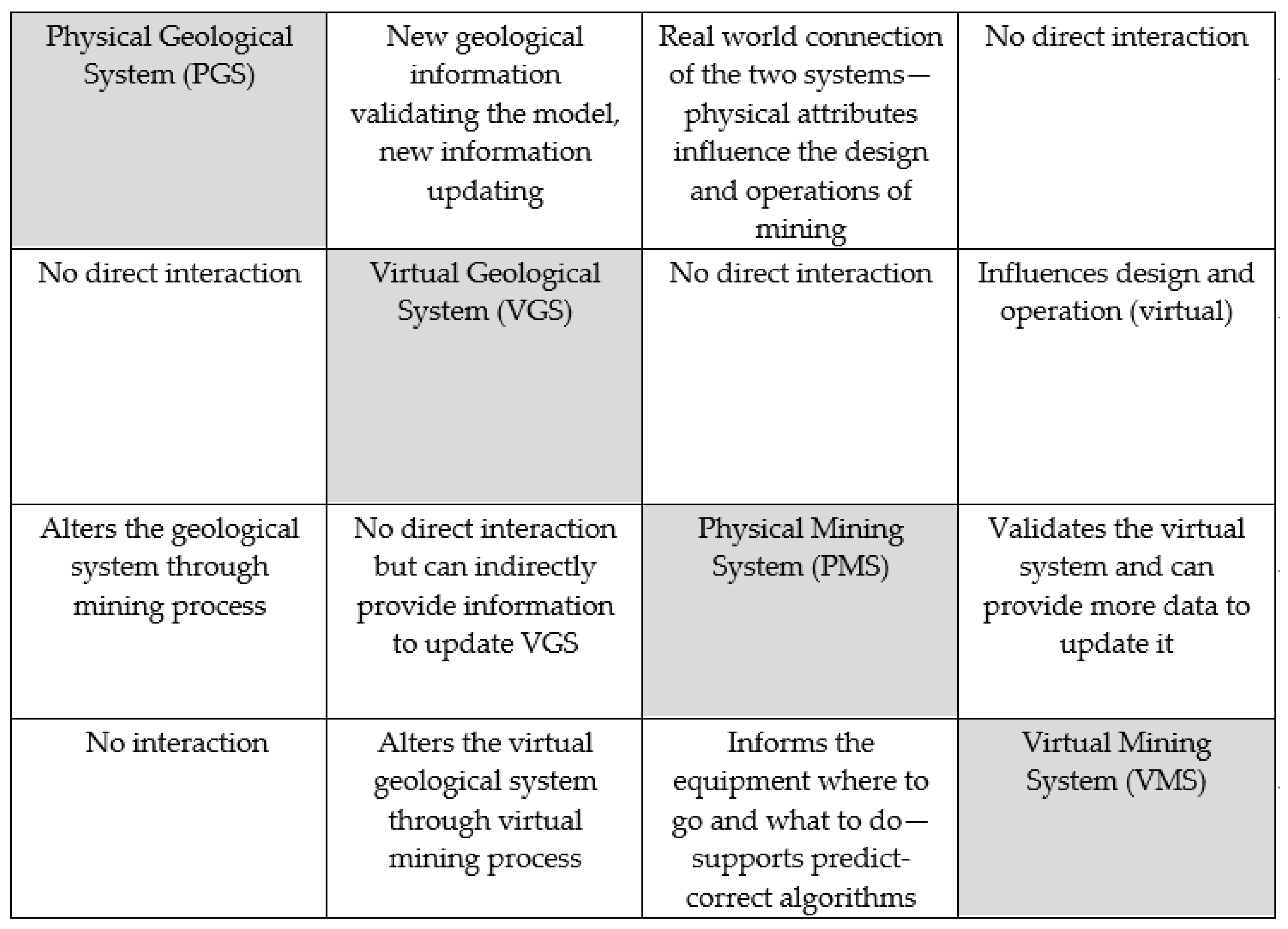
In relation to our aims to explore the requirements of a mining system’s digital twin, specifically in production or extraction, how it may interact with the uncertain geological model, and how the two models may be connected, the results show that the digitised geological system may, to some extent, fulfil the requirements of a digital twin and bear a relationship that could be connected through a unified repository. This would provide and receive updates on a near-real time basis with the mining twin. The digital twin of a mine must, however, operate with and within both the knowns and unknowns of the geological domain. These relationships can be conveyed through the use of an interaction matrix as described in the Rock Engineering Systems (RES) approach [32]. This is shown in Figure 2. Causality is coded in the clockwise direction.
While no direct connectivity is required between the virtual mining system (VMS) and the physical mining system (PMS) (Figure 2), a four-way connection may be needed to join the systems, to allow the geological digitised sibling (VGS + PGS) to become part of the mining twin (VMS + PMS). This means that the mining twin can continue to optimise operations as far as uncertainty within the geological digitised sibling will allow. Importantly, sensors built into the PMS can inform the VMS of new information received, that in turn will update the VGS, potentially in real time, making it closer to the reality of the PGS. Efforts such as those previously discussed that are being made to update and improve the VGS (geological model) are extremely valuable in improving the geological digitised sibling. Although it is an opportunity, it will also be a challenge, to develop the interface between the potentially “twinnable” engineered system and the natural domain with which it interacts. The epistemic uncertainty in the geological domain is usually significant, however, this is not so for individual mine site assets and processes where typically only stochastic uncertainty may need to be considered. For example:
- Stockpile: A digital twin of a stock- or spoil pile for instance may be possible, given that its engineering was planned and deliberately constructed with known and measurable particle characteristics (including grain size, chemistry and packing) in four dimensions.
- Processing plant: A digital twin of a processing plant including all its engineered components would be possible, with its digital twin environment being supplied with geological information on feed material.
- Mobile assets: reliability data on components associated with mobile assets (such as engine performance, tyre wear) can be used to build digital twins.
Mine assets that the authors argue to be too closely coupled to the geology (and hence inherit significant epistemic and stochastic uncertainty) to allow digital twin construction include:
- Slopes and underground excavations: epistemic and stochastic uncertainty in the geotechnical properties (rock mass structure, rock matrix strength and hydrogeology) mean current numerical simulation for slope deformation and underground convergence requires significant model simplification for it to be tractable. Quantitative prediction of low probability, high consequence events is still intractable. Rock fall and fall of ground simulation is even more challenging.
- Ore body: ore body knowledge is currently reliant heavily on geological modelling and geophysical sensing. Interpretation of geophysical data is currently heavily reliant on expert knowledge, and epistemic uncertainties associated with this process can be significant.
- Tailing dams and waste dumps: in particular for legacy structures, there is significant epistemic uncertainty associated with dam construction and consolidation, and stochastic uncertainty associated with material properties, combined with inadequate technologies for in situ monitoring of hydrological conditions.
Technological Advances that May Improve the Geological Model and Digital Twin
Operational flexibility can be built into operational planning [8] and continued improvements to geological (and hydrogeological) knowledge will help optimise planning and operations. In a dynamic model, mapping while drilling, taking advantage of logging data collected while drilling (logging-while-drilling, LWD) to update geological and geotechnical maps [20,33], will provide near-instant updates to inform the digitised geological model that in turn will inform the mine extraction and on-going planning process.
It is important to have a system that will allow co-visualisation of incoming data with the seismic, faulting and lithological horizon components of the current (and updating) model [34]. Ground-penetrating radar (GPR) is valuable for horizon-sensing [35,36] and can provide information that quickly updates a geological model for informing and optimising the open cut process. Ore-recognition tools that can quickly scan rock and drill-core in the mine, such as laser-induced breakdown spectroscopy (LIBS) [37], detect changes in rock fragments’ chemistry. Such information can allow stock piling and processing to be modified to suit what has been mined and can update the geological model that, in turn, will help improve its prediction and validity to help plan and inform the next mining stages.
Understanding what is behind the cut face is paramount to better managing the cutting direction in open cut and underground mines. Technologies such as look-ahead radar (LAR) [38] and thermal infrared-based methods to track seams [39] can provide valuable information to inform the mining equipment, but importantly can feed through to the geological model for frequent updating.
With respect to simulation, improved computing frameworks are gradually mitigating some of the limitations of the past. For example, the Multi-physics Object-Oriented Simulation Engine (MOOSE), developed for the nuclear industry [40] has general-purpose capabilities now being applied to mining, and in particular, groundwater modelling [41]. It supports massively parallel, fully coupled physics simulation, albeit within an extended-finite element framework which poses some limitations in the modelling of dynamically evolving fracture network geometries as required for many mining simulations.
Digital connectivity of mining equipment with the mining model (or cousin) will provide for rapid model updates to reduce uncertainties and improve reliability of models [42]. Methodologies can be developed to integrate the new data as it is received into 2D and 3D geological models as part of a workflow with automatically applied changes to boundaries and faults as modelling progresses [43]. Reliability or its lack, propagates through the system and will need to be allowed for in the engineering of the mine. As feedback to the geological cousin increases, the geological model in turn can provide improved certainty for engineering solutions.
5. Conclusions
A digital twin, which is more than a digital model or a digital simulation, is a connection via sensors and data, between a physical object and its digital model, to inform decision makers on current progress, and through simulation processes it uses that constantly update datasets to predict future processes. Unlike a model or simulation, it does not only measure or detect and predict one or few specific effects, conditions or behaviours. The term digital twin, therefore, implies a level of accuracy and precision that may not be applied to a complex natural system, such as in situ geology with its structural and physical complexities including numerous interactions and physical laws for all rock units, boundaries and characteristics. Further, despite recent advances in machine learning and algorithms, heavy reliance on expert opinion and manual intervention needed for validation and quality assurance, means that real-time or fast updates to the virtual geological system are currently not possible. While geological components and data can be used to inform the digital twin environment of engineered assets around a mine, that in itself does not make a geological digital twin, rather a digital twin of an operation or process, being informed by geological data. This importantly emphasises the use of digital twins in mining. The capacity to include geological data aligns the engineered system with the natural system.
Natural systems contain uncertainties and require a somewhat different approach to digital versions of engineered mining systems that can be more readily twinned. Engineered mining systems must act within the natural geological domain, the former having the capacity to be well known and digitally twinned, the latter having to capacity to be partially known and not digitally twinned.
Geological models (in situ rock boundaries, character and structure) may be well-constrained, but an early model could be considered, at best, a digitised ‘cousin’, having a relationship with reality but being far from its physical geological counterpart. Nevertheless, a digital mine’s sensors and real-time data-gathering capacity will provide the means to improve the digitised geological cousin. Coupling them providing constant iterations to the cousin, its relationship with reality will improve and could, potentially become a digitised sibling, having a relationship with reality, but still could not be considered its twin.
The usefulness of digital twins of components or of the whole mining system may be limited by the interface to the geological system, unless the in situ geological model is constantly updated by new data obtained by mining, that in turn can be used by the digital twin to further train itself and inform decision makers. The aim, therefore, should be to develop a digitised geological cousin that is well connected with components of the digital mine that can iteratively improve its relationship as mining progresses, informed by the ‘mining’ digital twin, so that the cousin may eventually become a digital sibling that can, in turn, better inform the mining system.
Challenges being addressed to assist mining automation and digitisation through sensing, architecture, automation connectivity and human-factors may be assisted through focused efforts to provide the geological model with real- or near real-time data. Digitisation of the engineering system providing data collection and storage can, through connectivity with the digitised geological cousin of sibling, improve the model that in turn can improve functioning of the mining equipment. Importantly, a digitised sibling might only resemble a twin after all rock has been mined and relevant data assimilated. Although the twin will represent something that is no longer there, it may provide an analogue or supervisory tool for future mining.
Author Contributions
Conceptualisation, J.H.H. and M.E.; Methodology, J.H.H.; Validation, J.H.H. and M.E.; Formal Analysis, J.H.H.; Investigation, J.H.H.; Writing—Original Draft Preparation, J.H.H.; Writing—Review and Editing, J.H.H. and M.E.; Visualisation, J.H.H.; Supervision, M.E.; Project Administration, J.H.H.; Funding Acquisition, M.E. All authors have read and agreed to the published version of the manuscript.
Funding
This research was internally funded by Commonwealth Scientific and Industry Research Organisation (CSIRO), Australia.
Conflicts of Interest
The authors declare no conflict of interest.
References
- Boschert, S.; Rosen, R. Digital Twin-The Simulation Aspect. In Mechatronic Futures; Hehenberger, P., Bradley, D., Eds.; Springer: Berlin/Heidelberg, Germany, 2016; pp. 59–74. [Google Scholar]
- Haag, S.; Anderl, R. Digital twin-Proof of concept. Manuf. Lett. 2018, 15, 64–66. [Google Scholar] [CrossRef]
- Qi, Q.; Tai, F. Digital twin and big data towards smart manufacturing and industry 4.0: 360 degree comparison. IEEE Access 2017, 6, 3585–3593. [Google Scholar] [CrossRef]
- Scharl, S.; Praktiknjo, A. The role of a digital industry 4.0 in a renewable energy system. Int. J. Energy Res. 2019, 43, 1–14. [Google Scholar] [CrossRef]
- Shafto, M.; Conroy, M.; Doyle, R.; Glaessgen, E.; Kemp, C.; LeMoigne, J.; Wang, L. NASA Technology Roadmap: Modeling, Simulation, Information Technology & Processing Roadmap Technology Area; NASA: Houston, Texas, USA, 2010.
- Grieves, M.; Vickers, J. Digital Twin: Mitigating Unpredictable, Undesirable Emergent Behavior in Complex Systems. In Transdisciplinary Perspectives on Complex Systems; Kahlen, F.J., Alves, A., Eds.; Springer: Berlin/Heidelberg, Germany, 2017. [Google Scholar]
- Glaessgen, E.H.; Stargel, D. The Digital Twin Paradigm for Future NASA and US Air Force Vehicles. In Proceedings of the 53rd Structural Dynamics Materials Conference Special Session: Digital Twin; American Institute of Aeronautics and Astronautics: Honolulu, HI, USA, 2012; pp. 1–14. [Google Scholar]
- Duany Ajak, A.; Lilford, E.; Topal, E. Application of predictive data mining to create mine plan flexibility in the face of geological uncertainty. Resour. Policy 2018, 55, 62–79. [Google Scholar] [CrossRef]
- Soleymani Shishvan, M.; Benndorf, J. The effect of geological uncertainty on achieving short-term targets: as quantitative approach using stochastic process simulation. J. South. Afr. Inst. Min. Metall. 2016, 116, 259–264. [Google Scholar] [CrossRef] [Green Version]
- EY. Future of Work: The Economic Implications of Technology and Digital Mining. A Report for the minerals Council of Australia; Ernst and Young: Brisbane, Australia, 2019; p. 59. [Google Scholar]
- Tinto, R. What in the world do mining and rocket science have in common? Rio Tinto Spotlight, 2020 [cited 2020 2nd January 2020]. Available online: https://www.riotinto.com/ourcommitment/spotlight-18130_26350.aspx (accessed on 2 January 2020).
- Grieves, M. Digital Twin: Manufacturing Excellence through Virtual Factory Replication-A White Paper; Digital Twin White Paper: Melbourne, FL, USA, 2014; p. 8. [Google Scholar]
- Ralston, J.C.; Hargrave, C.O.; Dunn, M.T. Longwall automation: trends, challenges and opportunities. Int. J. Min. Sci. Technol. 2017, 27, 733–739. [Google Scholar] [CrossRef]
- Wellmann, F.; Caumon, G. 3-D Structural geological models; concepts, methods and uncertainties, Advances in Geophysics. Adv. Geophys. 2018, 59, 1–121. [Google Scholar]
- Hodgkinson, J.H.; Fraser, S.J.; Donchak, P. Using Self-Organising Maps to Derive Lithological Boundaries from Geophysically-Derived Data in the Mt. Isa Region, QUEENSLAND. In ASEG2012-22nd IGEC Geophysical Conference; ASEG: Brisbane, Australia, 2012. [Google Scholar]
- Cracknell, M.J. Machine Learning for Geological Mapping Algorithms and Applications; University of Tasmania: Tasmania, Australia, 2014. [Google Scholar]
- Baecher, G.B.; Christian, J.T. Reliability and Statistics in Geotechnical Engineering; John Wiley & Sons: Hoboken, NJ, USA, 2003. [Google Scholar]
- Jing, L. A review of techniques, advances and outstanding issues in numerical modelling for rock mechanics and rock engineering. Int. J. Rock Mech. Min. Sci. 2003, 40, 283–353. [Google Scholar] [CrossRef]
- Benndorf, J.; Buxton, M.W.N. Sensor-based real-time resource model reconciliation for improved mine production control–a conceptual framework. Min. Technol. 2015, 125, 54–64. [Google Scholar] [CrossRef] [Green Version]
- Zhou, B.; Mason, I.; Greenhalgh, S.; Subramaniyan, S. Seeing coal-seam top ahead of the drill bit through seismic-while-drilling. Geophys. Prospect. 2014, 63, 166–182. [Google Scholar] [CrossRef]
- Zhou, B.; Hatherly, P.; Sun, W. Enhancing the detection of small coal structures by seismic diffraction imaging. Int. J. Coal Geol. 2017, 178, 1–12. [Google Scholar] [CrossRef]
- Giovanna, S.; Cristian, C.; Francesca, A.; Anna, G.; Maria, S.; Davide, G.; Roberto, O.; Giancarlo, B. Spectral classification and mineralogical characterization of Nili Fossae for a better understanding of hydrated mineralogies. In 13th EGY General Assembly; European Geosciences Union: Vienna, Austria, 2017. [Google Scholar]
- Maybee, B.; Lowen, A.; Dunn, P. Risk-based decision making within strategic mine planning. Int. J. Min. Miner. Eng. 2010, 2, 1754–8918. [Google Scholar] [CrossRef]
- Jessell, M.; Aillères, L.; Kemp, E.d.; Lindsay, M.; Wellmann, F.; Hillier, M.; Laurent, G.; Carmichael, T.; Martin, R. Next generation three-dimensional geologic modeling and inversion. Soc. Econ. Geol. 2014, 18, 261–272. [Google Scholar]
- Read, J.; Stacey, P. Guidelines for Open Pit Slope Design; CSIRO Pulblishing: Brisbane, Australia, 2009. [Google Scholar]
- Bárdossy, G.; Fodor, J. Traditional and new ways to handle uncertainty in geology. Nat. Resour. Res. 2001, 10, 179–187. [Google Scholar] [CrossRef]
- Rossiter, D.G. Lecture notes “Land Evaluation”. Part 5: Uncertainty. In College of Agriculture and Life Sciences; Cornell University: Ithaca, NY, USA, 1995. [Google Scholar]
- Mann, C.J. Uncertainty in Geology. In Computers in Geology-25 Years of Progress; David, J.C., Herzfeld, U.C., Eds.; Oxford University Press: Oxford, UK, 1993; pp. 241–254. [Google Scholar]
- Australian Centre for Geomechanics. Mining Geomechanical Risk; ACG: Perth, Australia, 2019. [Google Scholar]
- Dunn, M.J. Quantifying uncertainty in mining geomechanics design. In Proceedings of the First International Conference on Mining Geomechanical Risk; Wesseloo, J., Ed.; Australian Centre for Geomechanics: Perth, Australia, 2019; pp. 391–402. [Google Scholar]
- Hadjigeorgiou, J. Understanding, managing and communicating geomechanical mining risk. In Proceedings of the First International Conference on Mining Geomechanical Risk; Wesseloo, J., Ed.; Australian Centre for Geomechanics: Perth, Australia, 2019; pp. 3–20. [Google Scholar]
- Hudson, J.A. Rock Engineering Systems: Theory and Practice. In Ellis Horwood Series in Civil Engineering, Geotechnics; Ellis Horwood Ltd.: Chichester, UK, 1992; p. 185. [Google Scholar]
- Zhang, W.; Lin, C.; Zhou, M.; Wang, H. Application of geological model dynamic updating method in the Guanjiapu Oilfield, Dagang. Pet. Explor. Dev. 2010, 37, 220–225. [Google Scholar]
- Thevoux-Chabuel, H. Integrating real-time drilling information into the geological model. First Break 2009, 27, 63–67. [Google Scholar]
- Che, J.-K.; Chen, C.C.; Stolarczyk, L.G.; Duncan, J.T. Novel in-situ boundary detection algorithm for horizon control in longwall mining. IEEE Geosci. Remote Sens. Lett. 2017, 14, 1875–1879. [Google Scholar] [CrossRef]
- Ralston, J.C.; Strange, A.D. An industrial application of ground penetrating radar for coal mining horizon sensing. In Proceedings of the 2015 International Symposium on Antennas and Propagation (ISAP), Hobart, Australia, 9–12 November 2015; pp. 1–4. [Google Scholar]
- Khajehzadeh, N.; Kauppinen, T.K. Fast mineral identification using elemental LIBS technique. In Proceedings of the 4th IFAC Workshop on Mining, Mineral and Metal Processing, MMM 2015; IFAC PapersOnLine: Oulu, Finland, 2015; pp. 119–124. [Google Scholar]
- Bausov, I.Y.; Stolarczyk, G.L.; Stolarczyk, L.G.; Koppenjan, S.D.S. Look-ahead radar and horizon sensing for coal cutting drums. In Proceedings of the IEEE 4th International Workshop on Advanced Ground Penetrating Radar, Aula Magna Partenope, Italy, 27–29 June 2007. [Google Scholar]
- Ralston, J.C.; Strange, A.D. Developing selective mining capability for longwall shearers using thermal infrared-based seam tracking. Int. J. Min. Sci. Technol. 2013, 23, 47–53. [Google Scholar] [CrossRef]
- Idaho National Laboratory. Multiphysics Object Oriented Simulation Environment (‘MOOSE’) Open Source Multiphysics; INL: Idaho Falls, ID, USA, 2008. [Google Scholar]
- Adhikary, D.P.; Wilkins, A. C18016 Reducing the Impact of Longwall Extraction on Groundwater System; ACARP, Ed.; Australian Coal Association Research Projects: Brisbane, Australia, 2012. [Google Scholar]
- Hardy, D. Rapid model updating allows right-time decision-making. Exploration and Production Magazine. January 2009. Available online: https://www.emerson.com/documents/automation/article-hart-e-p-reservoir-management-roxar-en-81766.pdf (accessed on 3 March 2020).
- Omeragic, D.; Polyakov, V.; Shetty, S.; Brot, B.; Habashy, T.M.; Flugsrud, T.L. Workflow to automatically update geological models during well placement with high angle and horizontal well log interpretation results. In Society of Petroleum Engineers Digital Energy Conference and Exhibition; Society of Petroleum Engineers: The Woodlands, TX, USA, 2013. [Google Scholar]
Figure 1.
Schematic showing key components of digital twins.
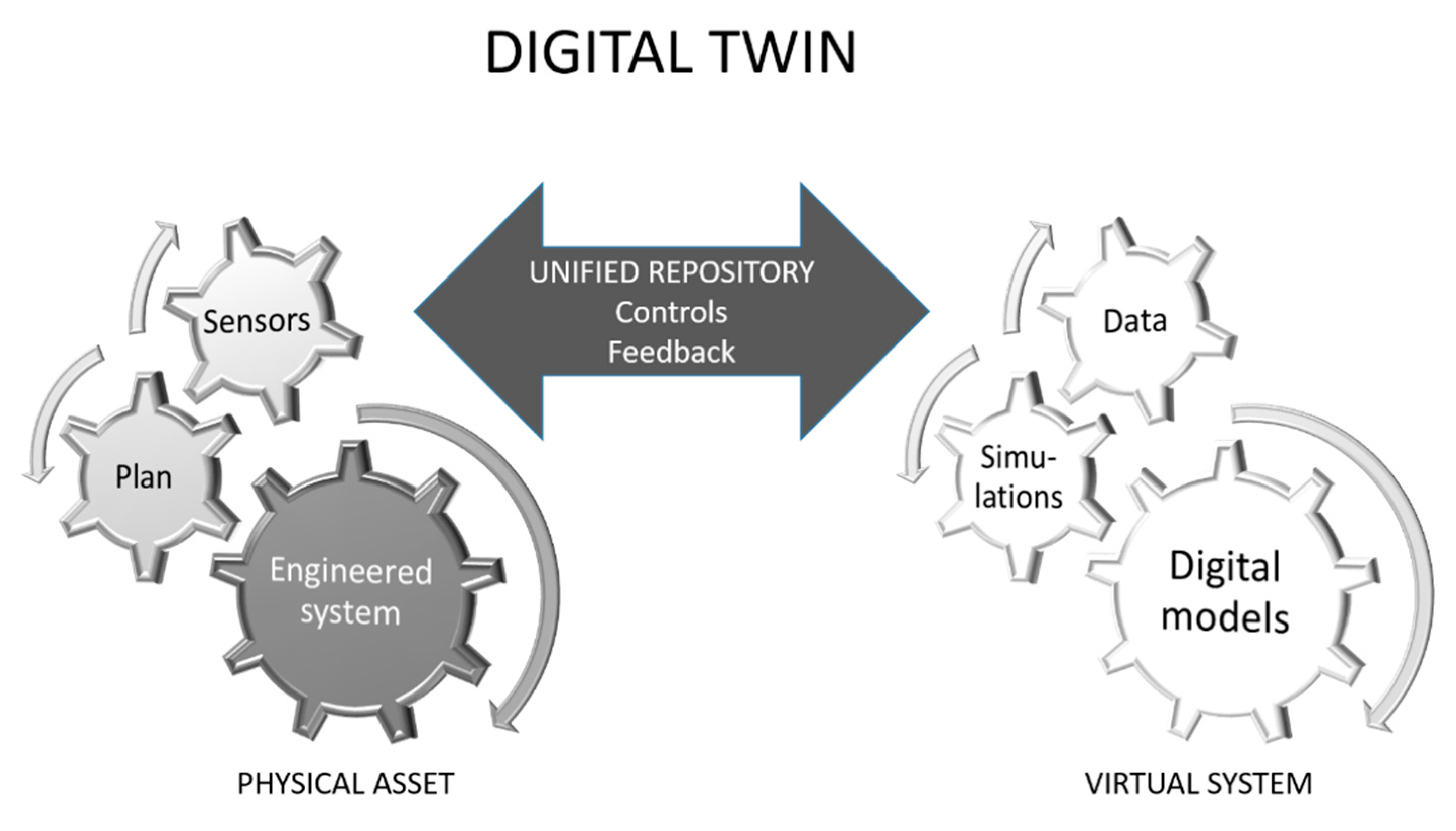
Figure 2.
An interaction matrix to illustrate clockwise connections between the physical and virtual parts of the mining twin and the geological sibling (geological system refers to geology, hydrogeology and geotechnical models and systems in this matrix).
Figure 2.
An interaction matrix to illustrate clockwise connections between the physical and virtual parts of the mining twin and the geological sibling (geological system refers to geology, hydrogeology and geotechnical models and systems in this matrix).

Table 1.
Typical geological, hydrogeological and geomechanical model-development inputs and methods (although commercially available methods may differ), how each provides value to knowing the geological environment, potential for improvement over time and an assessment of their capacity to match reality given the ‘best possible scenario’.
| Typical Input Data and Methods | Value | Improvement Potential | Potential to Support a Digital Geological Twin |
|---|---|---|---|
| Non-geophysical drill hole data | Pins down known information spatially | Improves with greater drill hole density and more core recovery | Impractical in near future to achieve required hole density for high resolutions (<50 cm desired in underground operations) |
| Down-hole logging data | Complete logging provides good information on geology | Value depends on drill hole density and core recovery/quality, and detail from methods (such as Corescan, Hylogger) | Interpolation and interpretation required, impractical in near future to achieve required hole density. Restricts data collection and incorporation |
| Geological maps (surface/outcrops) Developed using various processes, simulations, geostatistical models | Provides in-field direct and indirect information, depends on connectivity between surface and subsurface, depends on cover | Improves with less cover, may be useful for correlating with down-hole information, may not be able to improve depth analysis if lacking detail or connectivity | High potential to define surface twin, potential to constrain twin at subsurface depending on methods. |
| Geophysics—regional and cross-hole including, processes, simulations | Provides broad scale information, may detail | Improves with more hole density and seismic surveys | Interpolation and interpretation required but restricted, impractical in near future to achieve volumetric sampling required |
| Lithological and geochemistry data from mapping, hand specimens, core | Provides point information on lithology, rock character | Value depends on drill hole density and core recovery/quality Improves with more samples, better core recovery, more drill holes, more detailed lab analysis | Sparse data at best (prior to full excavation of rock mass after which lithology may be remodelled) |
| Stratigraphic modelling outputs (interpolated cross-holes) | Combines direct and indirect information | Improves with more samples, improved integrity of core, and greater drill hole density | Direct information sparse prior to full excavation of rock mass, after which stratigraphy may be remodelled |
| Structural modelling outputs (from surface, core observations; interpretation from geophysics) | Provides direct and indirect information; depends on recovery and integrity of core, quality and quantity of geophysics | Improves with more samples, improved integrity of core, and greater drill hole density, greater density of geophysical analysis | Large/regional structures could be estimated to closely match reality. Mine- and finer-scale detail, not possible to match reality at mine scale prior to full excavation of rock mass—after which full detailed structure may be reinterpreted |
| Boundary contact mapping outputs (from core, down-hole geophysical characteristics, interpolated cross-holes) | Provides direct and indirect information; depends on recovery and integrity of core and quality and quantity of geophysics techniques used | Improves with more samples, improved integrity of core, and greater drill hole density, geophysical analysis | Not at mine scale prior to full excavation of rock mass—after which full detailed structure may be reinterpreted |
| Hydrogeological data—piezometer readings, Ground penetrating radar, water table data | Provides direct and indirect information; depends on frequency of data collection and density of piezometers | Improves with more water observations, natural levels disturbed deliberately for mining | Not at mine scale during or after mining. Informed estimates and modelling at best. Water pumping will change water level data |
Table 2.
Assessment of engineered and non-engineered systems regarding their abilities to fulfil digital twin requirements.
Table 2.
Assessment of engineered and non-engineered systems regarding their abilities to fulfil digital twin requirements.
| Part of the Digital Twin | Digital Twin Fulfilment Requirements (after Grieves, 2014 [12]) | Engineered Mining System | Non-Engineered Geological System |
|---|---|---|---|
| The physical system | Components and boundaries identified and defined | POSSIBLE depending on its interaction with geological unknowns | PARTIALLY POSSIBLE restricted by data availability (see Table 1) |
| Unified repository (UR) | Possible to connect between the physical and virtual process in constant real-time or near real-time communication; populate UR by data from them both | POSSIBLE assuming few mechanical unknowns in both virtual and physical systems | PARTIALLY POSSIBLE restricted by capacity for data collection and incorporation (see Table 1) |
| The virtual system | All information ‘as designed’ available for each component such as dimensions, tolerances, torque requirements, strength, capacity, hardness requirements); geometry and connectivity between components | POSSIBLE depending on interaction with geological unknowns | PARTIALLY POSSIBLE restricted by data availability and interpretation (see Table 1) |
© 2020 by the authors. Licensee MDPI, Basel, Switzerland. This article is an open access article distributed under the terms and conditions of the Creative Commons Attribution (CC BY) license (http://creativecommons.org/licenses/by/4.0/).
Share and Cite
MDPI and ACS Style
Hodgkinson, J.H.; Elmouttie, M. Cousins, Siblings and Twins: A Review of the Geological Model’s Place in the Digital Mine. Resources 2020, 9, 24. https://doi.org/10.3390/resources9030024
AMA Style
Hodgkinson JH, Elmouttie M. Cousins, Siblings and Twins: A Review of the Geological Model’s Place in the Digital Mine. Resources. 2020; 9(3):24. https://doi.org/10.3390/resources9030024
Chicago/Turabian StyleHodgkinson, Jane H., and Marc Elmouttie. 2020. "Cousins, Siblings and Twins: A Review of the Geological Model’s Place in the Digital Mine" Resources 9, no. 3: 24. https://doi.org/10.3390/resources9030024
Note that from the first issue of 2016, this journal uses article numbers instead of page numbers. See further details here.