1. Introduction
With the rapid growth in vehicle numbers and the expansion of cities, traffic incidents have a broad and growing negative impact on both traffic systems and the quality of social activities. The management of traffic safety plays an important role in intelligent transportation systems (ITSs). Traffic safety management constitutes a broad area of research where it is important to analyze and predict the influence of traffic incidents. Traffic incident management (TIM) can be implemented to mitigate the economic losses caused by an incident if the influence is correctly predicted [
1]. According to recent studies, traffic incident influence prediction methods can be categorized into two groups: macroscopic road network influence prediction and microscopic road network influence prediction.
The first group of methods is data-driven, and predicts the influence on macroscopic road networks based on auxiliary traffic sensors such as inductance coils, cameras, and global positioning system (GPS) devices. Spatial data-mining methods are often applied to predict the influence of traffic incidents. For example, Pan et al. [
2] used a polynomial regression model to quantify the spatiotemporal effect of traffic incidents. The method was developed using a large-scale dataset spanning three years. Miller and Gupta [
3] proposed a practical system for predicting the cost and effect of highway incidents using classification models trained with police reports and over 60 million sensor data points. Xu et al. [
4] proposed a self-adapting framework for online traffic prediction using historical data over five years. Although these data-driven methods functioned well on large road networks, the requirements of the historic datasets make it costly for implementation in the real world.
As one of the most important applications of geographic information system (GIS) technology [
5], GIS for transportation (GIS-T) contributes substantially to the analysis of traffic incidents, for example, data models [
6,
7], incident hotspot analysis [
8,
9] and road network vulnerability [
10,
11]. These studies analyzed fundamental GIS data for use in TIM. Additionally, Anbaroglu et al. [
12] developed a spatiotemporal clustering method for detecting non-recurrent congestion and traffic incidents on road networks, which could improve the efficiency of ITSs. Wu et al. [
13] developed a traffic incident early warning system to broadcast incident and congestion information to drivers via location-based service (LBS) techniques. The aforementioned analytical methods detect and broadcast traffic incidents, while the dynamic process may be disregarded. The influence of an incident may spread and dissipate on the road network; therefore, given this process, dynamic spatial analysis should be introduced to predict the dynamic influence scope of an incident.
Research on traffic incidents in transportation science has focused on driving behaviors and physical models. For example, cellular transmission modeling (CTM) has been applied to simulate the formation and dissipation of traffic jams at the microscopic level [
14,
15]. This model considers driving behaviors, such as lane changing, acceleration, and deceleration. Similarly, car-following models describe the processes by which drivers follow each other in the traffic stream [
16] to better simulate the congestion and dissipation caused by traffic incidents. These microscopic models focus on typical road structures, such as intersections, freeways, and rectangular grid networks, to achieve precise results. In contrast, macroscopic network traffic simulation models derived from the LWR kinematic wave theory [
17], have recently been proposed to simulate and predict various traffic behaviors, including incidents on large road networks [
18,
19]. Despite the comprehensive results obtained using these methods, the long computation times have made these techniques non-optimal for implementation within TIM. Moreover, the spatial transferability of these microscopic methods is limited, and they cannot be applied to real road networks.
In particular, methods focusing on secondary incident identification also consider predicting the spatiotemporal influence of incidents. These approaches mostly utilize statistical and physical algorithms to calculate the influence scope of primary incidents, therefore, leading to a better detection of secondary incidents. For example, Imprialou et al. [
20] applied a spatiotemporal speed evolution method to imprint the dynamic of the influence scope, taking advantage of detector data. Similarly, methods using Bayesian learning approach [
21,
22], deterministic queuing diagrams [
23,
24] and regression models [
25] can also determine the extent of an incident. These approaches can determine the spatiotemporal influence of incidents; however, they rely on historical data and their implementation is limited within freeways. The research of Sarker et al. [
26] is closely related to ours; they proposed a dynamic approach to determine the spatiotemporal thresholds of incidents in a large-scale road network. Their estimation was based on shockwave theory and validated to have over 70% accuracy. On the other hand, although this approach considered queuing on freeways or arterial roads, more specific behaviors at the intersection remained disregarded.
As the nature of transportation issues is dynamic and spatial [
27], a macroscopic data-driven method cannot avoid large training sets. Static analytical methods of GIS ignore the dynamic nature of transportation, and microscopic transportation models have limited spatial transferability. In other words, the relevance of geospatial information for transport modeling is significant, but not yet adequately considered in most cases [
28], which has even been unsettled in recent years. Thus, transportation models should be integrated with spatiotemporal GIS analysis techniques to accommodate the dynamics of traffic incidents. With the ability to predict traffic effects dynamically, specific TIM can be implemented to mitigate the loss caused by traffic incidents.
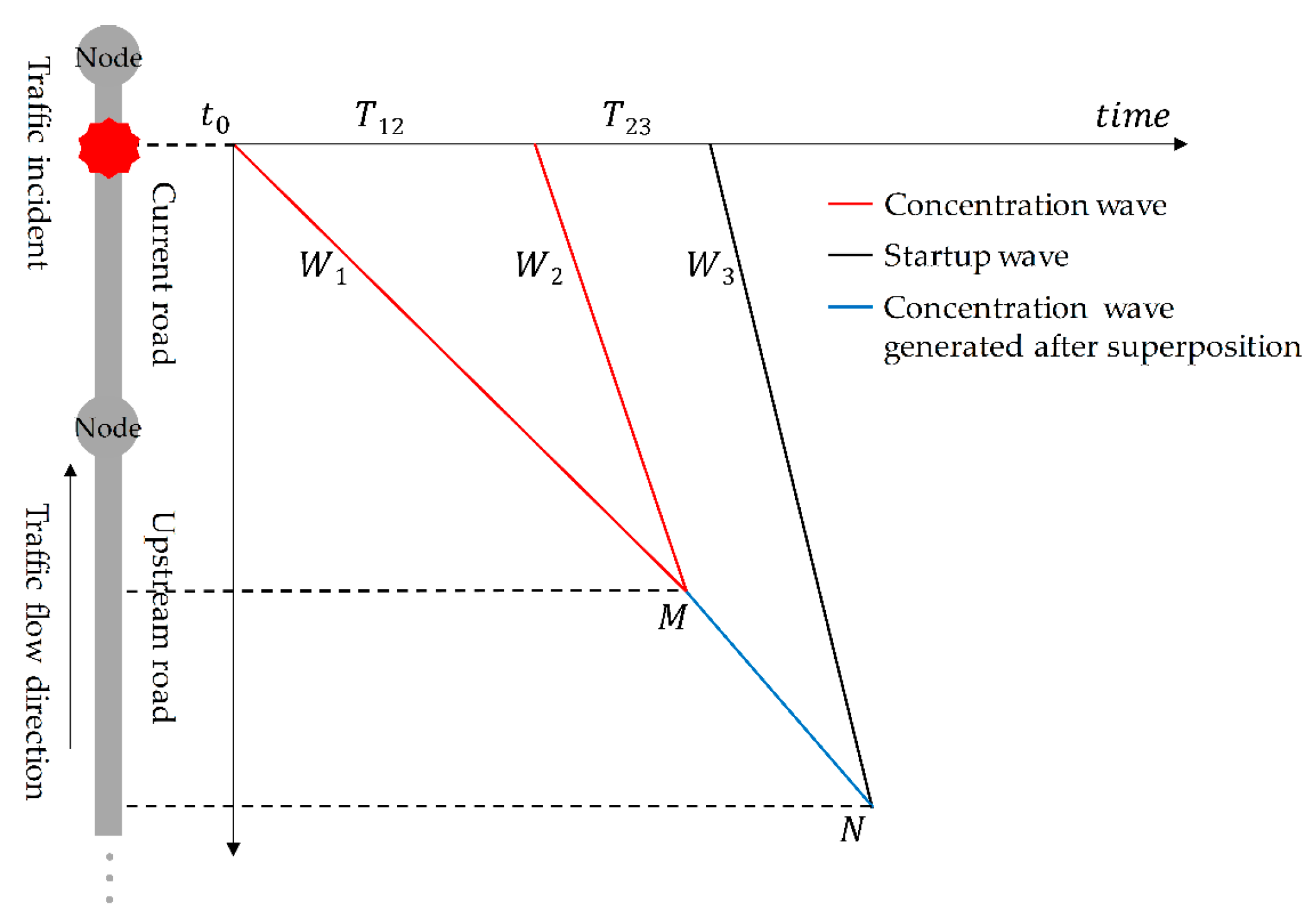
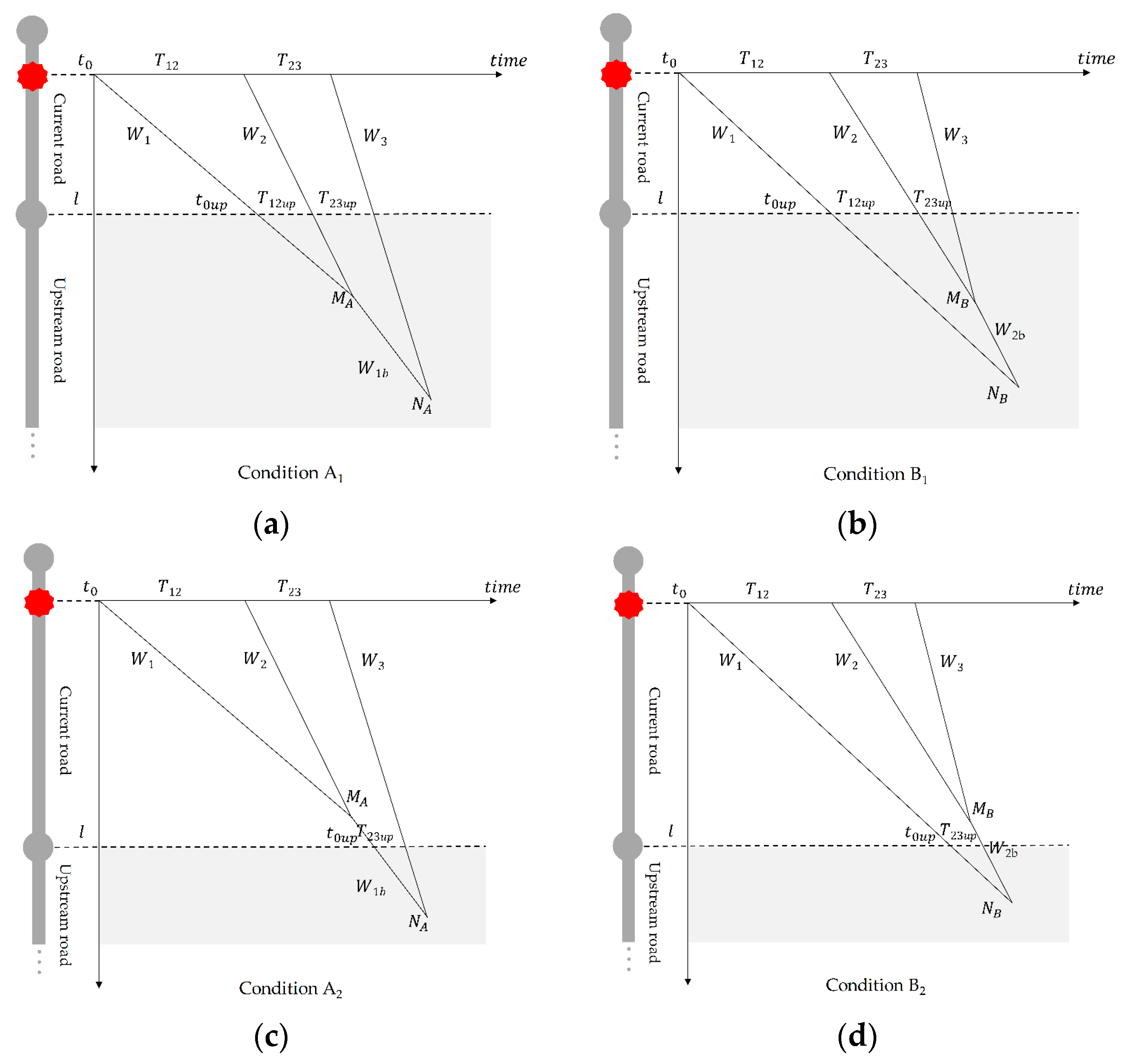
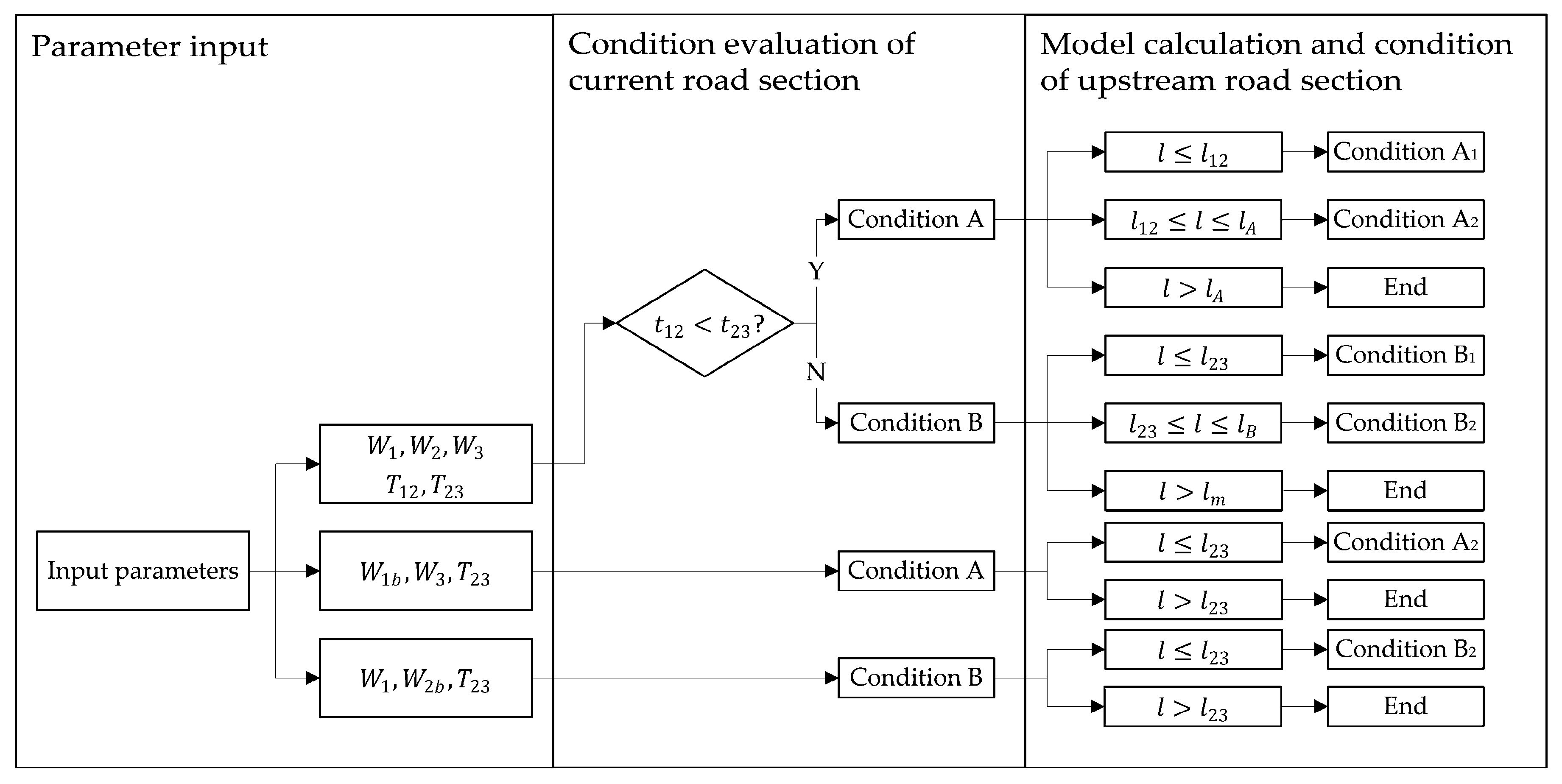
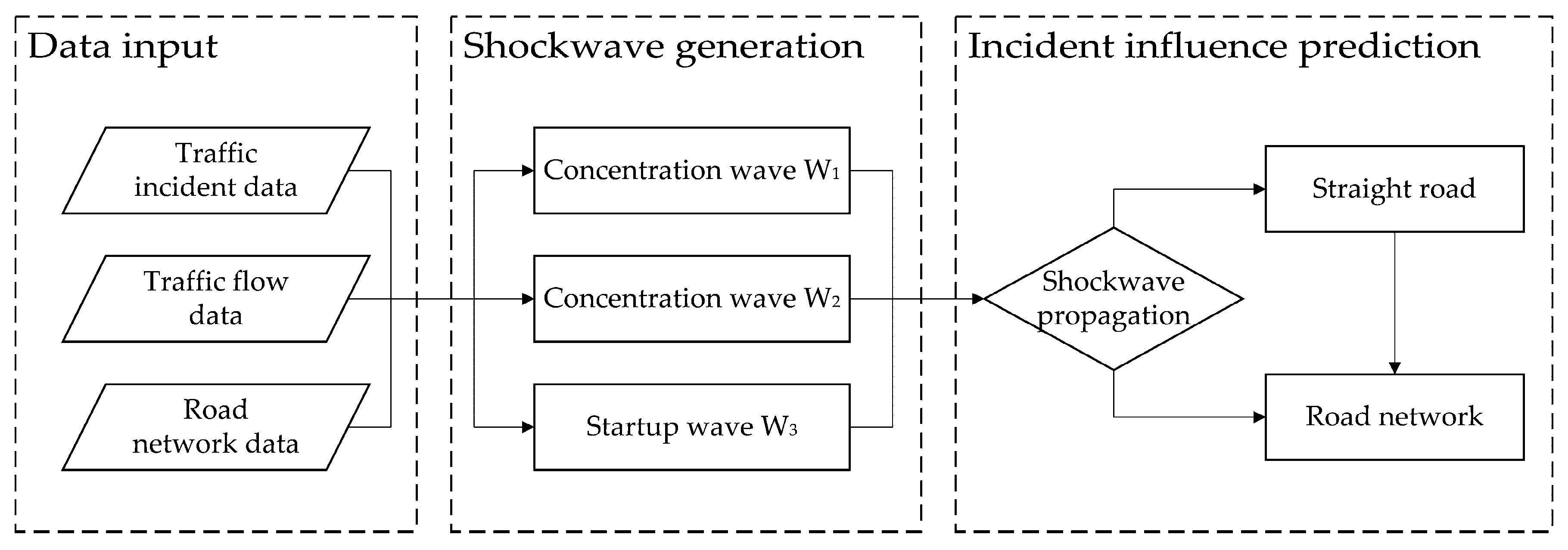
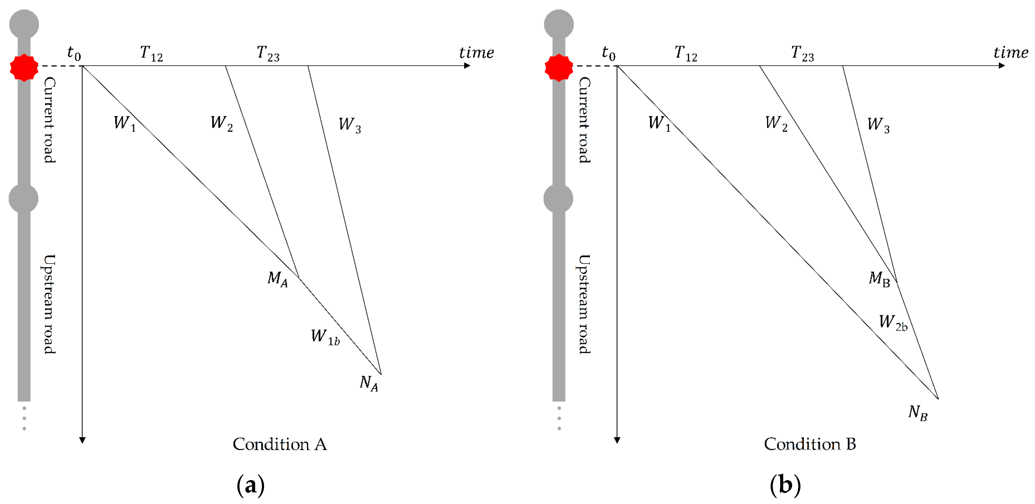
This paper presents a dynamic spatiotemporal analysis model to predict the influence of traffic incidents. This model integrates the traffic shockwave model and GIS road network to analyze the spread of the influence of these incidents. GIS road networks provide required information, such as the number of lanes, road capacity, and speed limit, to the proposed model. Shockwaves, including concentration waves and startup waves, are generated over the time period during which an incident occurs, the police arrive, and the incident is cleared. These shockwaves are superposed during the propagation along the roads and through intersections. To clearly describe the propagation of shockwaves in an actual road network, two situations involving straight roads and road networks were summarized. Relative to other methods, the proposed model uses fewer dynamic parameters and predicts their influence on a broader set of road hierarchies.
4. Conclusions and Future Work
This paper presented a dynamic spatiotemporal analysis model predicting the influence of traffic incidents with the assistance of a GIS database and knowledge of the road network. This model used a traffic shockwave model, and different superposition situations of shockwaves were proposed for both straight roads and road networks. This approach ensures that the influence is transferred along the upstream of the road, and then propagates through turns to minor roads.
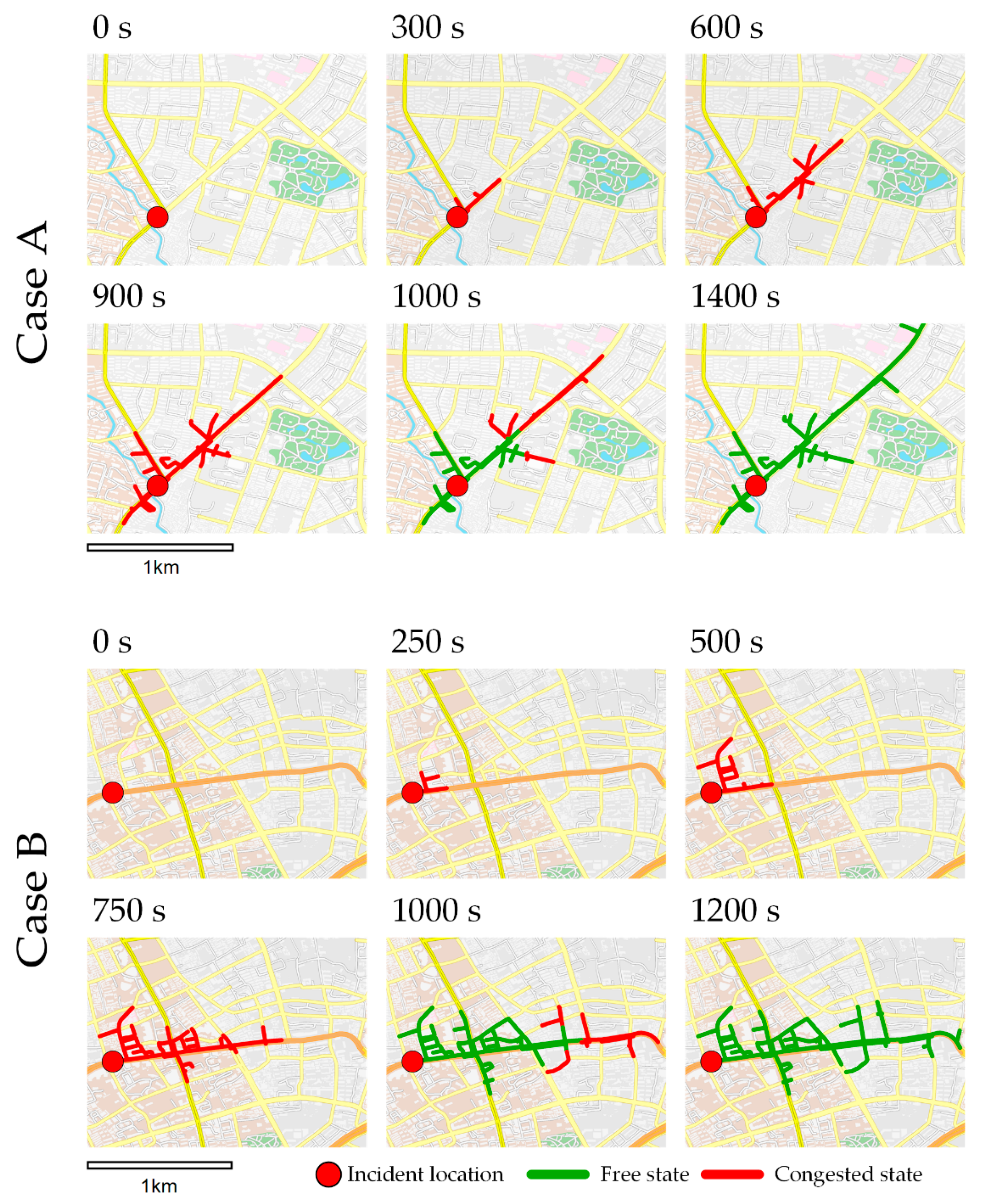
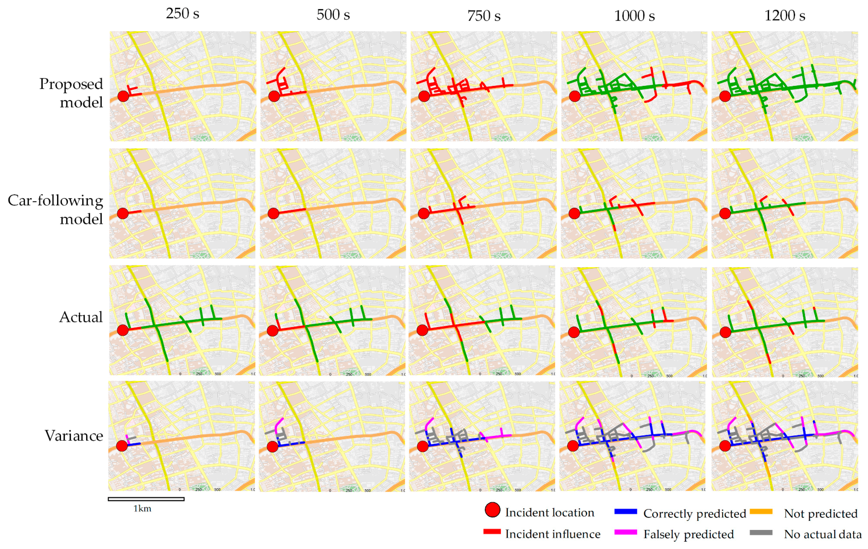
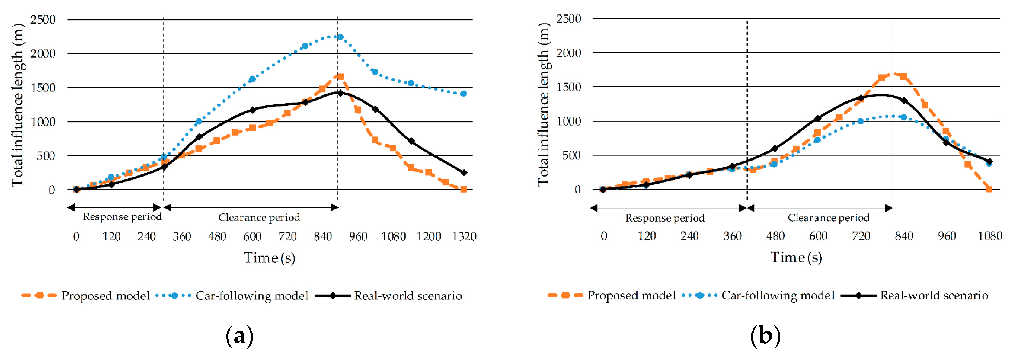
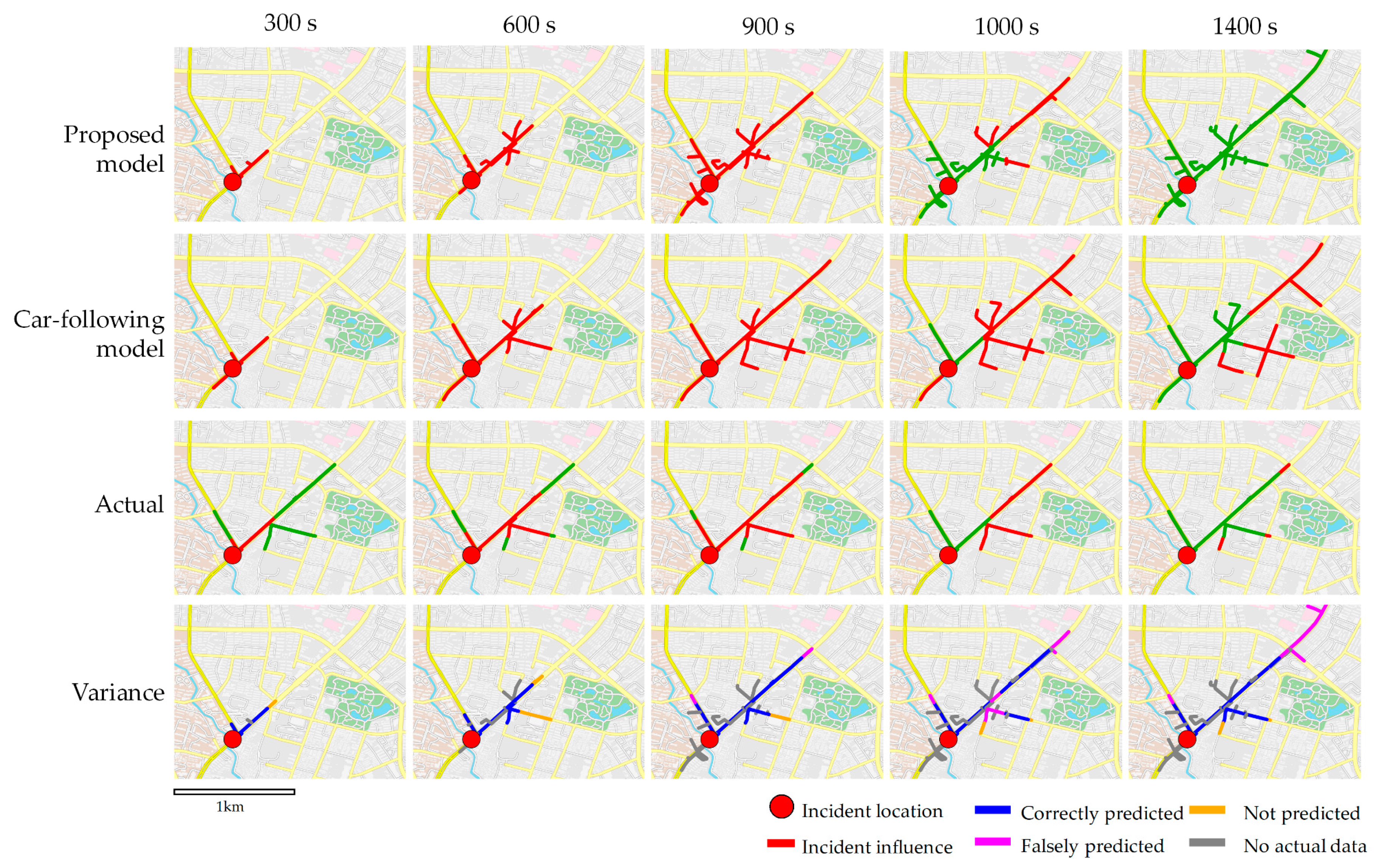
Two typical incidents occurring in Shanghai were selected to verify the proposed model and compare it against the car-following model and actual monitoring data. The results showed that the proposed model successfully predicted the congestion of a main road in the response period and that the degree of false prediction increased during the clearance period. Relative to the actual monitoring data, the proposed model generally reached an accuracy of over 60%. Moreover, the proposed model required fewer computation resources and could be used to predict a broader set of road hierarchies than the car-following model.
The novelty of the proposed model is that the shockwave traffic model can be successfully integrated with GIS spatiotemporal analysis to predict the congestion situation for incidents and for different road hierarchies. Compared with data-driven methods like those in [
2,
3,
4], only few historical data and dynamic parameters are required for the model, ensuring that the proposed model could be used in most traffic prediction systems and ITSs. Compared with the approach described in [
26], this method describes the influence of traffic incidents not only on freeways, but also on surface streets using dynamic incident data. The propagation of shockwaves through intersections was also tackled by considering the different behaviors of shockwaves towards straight and turning roads.
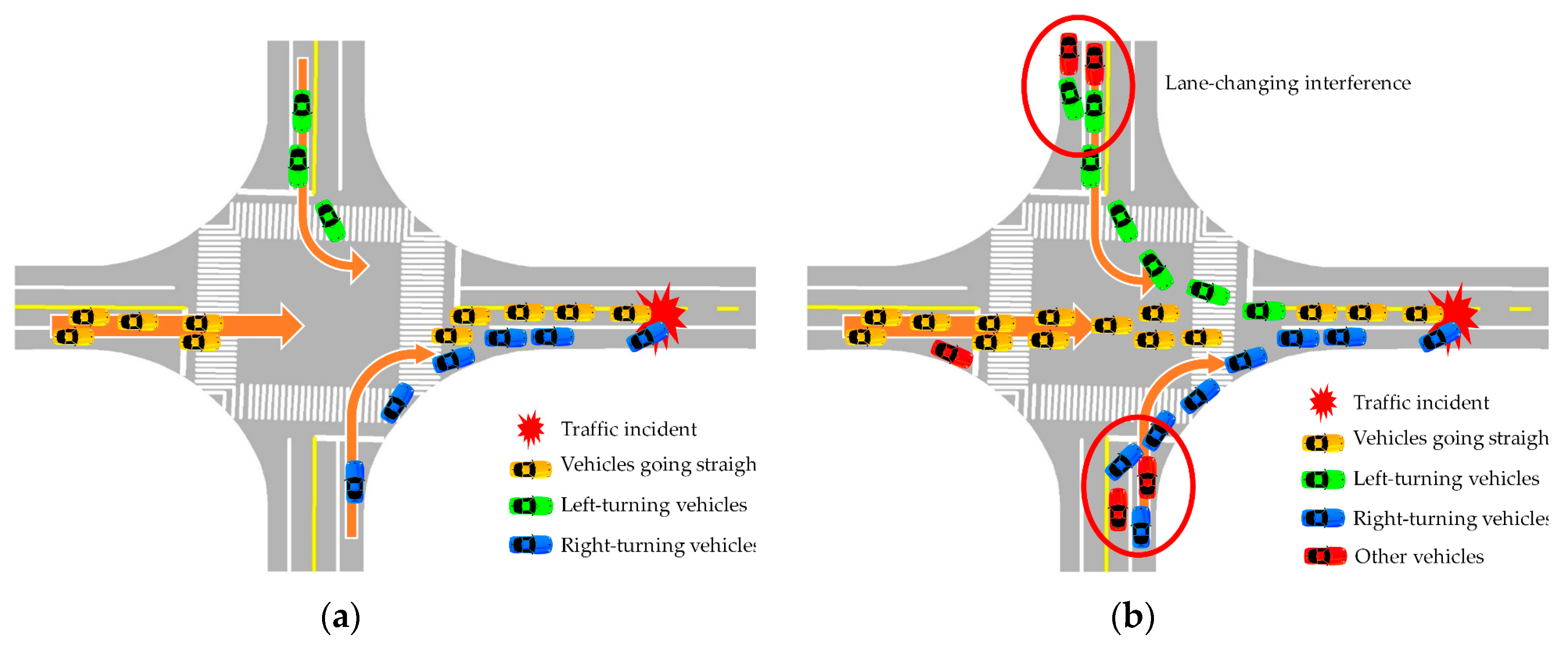
The proposed shockwave model simplifies the process procedure of driving behavior and collector road networks. In the model, the lane-changing behavior under the context of congestion and dissipation was abstracted into the propagation of shockwaves. However, this idealization may lead to less accurate prediction, as more complex traffic phenomena on downtown high-density road networks are omitted. In future work, we plan to expand the model to consider more complex scenarios to achieve more precise results such as considering the perturbation of shockwaves caused by lane changing on collector roads.
In this paper, the traffic flow and GIS road network data were provided by the Traffic Administration Department of the Chinese Government. However, the actual traffic flow changes daily, which will decrease the accuracy of the proposed model. The accuracy can be restored if the real-time traffic flow of a road is imported to the proposed model.
Another limitation of the proposed model is that the incident was assumed to require police intervention. However, some incidents involving lower economic losses and unambiguous responsibility are non-disruptive according to local traffic management laws. Therefore, the response time and clearance time of the model will not be provided. In this situation, the incident location can be automatically detected, and the clearance time can be estimated by the ITS of the city.


