Article

Long-Term Trend Analysis of Precipitation and Air Temperature for Kentucky, United States

by
Somsubhra Chattopadhyay
and
Dwayne R. Edwards
*
Department of Biosystems and Agricultural Engineering, University of Kentucky, Lexington, KY 40546, USA
*
Author to whom correspondence should be addressed.
Climate 2016, 4(1), 10; https://doi.org/10.3390/cli4010010
Submission received: 19 November 2015 / Revised: 19 January 2016 / Accepted: 20 January 2016 / Published: 3 February 2016
(This article belongs to the Special Issue Impact of Climate Change on Water Resources)

Abstract

:
Variation in quantities such as precipitation and temperature is often assessed by detecting and characterizing trends in available meteorological data. The objective of this study was to determine the long-term trends in annual precipitation and mean annual air temperature for the state of Kentucky. Non-parametric statistical tests were applied to homogenized and (as needed) pre-whitened annual series of precipitation and mean air temperature during 1950–2010. Significant trends in annual precipitation were detected (both positive, averaging 4.1 mm/year) for only two of the 60 precipitation-homogenous weather stations (Calloway and Carlisle counties in rural western Kentucky). Only three of the 42 temperature-homogenous stations demonstrated trends (all positive, averaging 0.01 °C/year) in mean annual temperature: Calloway County, Allen County in southern-central Kentucky, and urbanized Jefferson County in northern-central Kentucky. In view of the locations of the stations demonstrating positive trends, similar work in adjacent states will be required to better understand the processes responsible for those trends and to properly place them in their larger context, if any.

1. Introduction

Precipitation and air temperature are two of the most important variables in the fields of climate sciences and hydrology. Precipitation is a critical component in rainfall-runoff relationships, and influences flood/drought assessment as well as mitigation measures. Temperature plays a prominent and well-known role in evaporation, transpiration, and water demand (both animal and human), and thus significantly affects both water requirements and strategies to assure its availability. The implications of changes in precipitation and temperature make it crucial for water resource planners to accurately assess their behavior and impacts on related hydrologic variables.

1.1. Relationship between Climate Data and Hydrologic Studies

Modeling studies, with hydrologic simulation models operated with data projections from climate models, have recently been undertaken to assess the potential hydrologic impacts of changing climate [1,2,3,4,5,6]. Ficklin et al. [1] applied a hydrologic model to the Upper Colorado River Basin and combined it with forecast data from 16 Global Climate Models (GCMs), finding a temporal shift in most hydrologic outputs with a significant decline in snowmelt projected by the end of the 21st century. Additionally, projected temperature increases translated to increased (23%) estimates of average annual evapotranspiration. In a similar study focusing on the Haw River Watershed in North Carolina, Chattopadhyay and Jha [2] linked the Soil and Water Assessment Tool (SWAT) model [7] with climate projections from four Regional Climate Models (RCMs). The study indicated that an overall average 14% increase in precipitation would increase water yield by a disproportionately high 38% on an annual basis. Jin and Sridhar [3] used the same basic approach for hydrologic cycle impact assessment in the Boise and Spokane River Basins but used a different suite of climate models. For the Spokane River watershed, the projected precipitation changes ranged from 3.8% to 36%, and projected temperature changes ranged from 0.0 to 3.9 °C over the study period (2010–2060), corresponding to estimated changes in annual peak flows ranging from −58 to 106 m3/s. The results for the Boise River watershed were similar; precipitation changes of −6.7%–17.9% and temperature changes of 0.1–3.5 °C were projected to change annual peak flows by −198–88 m3/s. The general findings of modeling studies such as these are strengthened by observations of hydrologic cycle changes on regional to global scales, attributable to greenhouse gas emissions [8,9,10,11]. The hydrologic cycle, then, responds in predictable ways to variation in influential variables, sometimes in a more-than-proportional manner. This outcome magnifies the importance of characterizing future climate in the context of hydrology.

1.2. Trends in Air Temperature

Many studies, representing a wide range of locations and scales, have investigated trends in climatic variables [12,13,14,15,16,17,18]. The overall trend with respect to temperature seems clear at the global scale. According to [19], global mean annual temperature, for both surface and ocean air in combination, has increased by 0.65–1.06 °C over the period 1880–2012. At smaller spatial and temporal scales, there is less uniformity of findings. Zhao et al. [20] reported that mean surface air temperature in Eastern China increased by 1.52 °C over the last 100 years. In a similar study, Ceppi et al. [21] analyzed seasonal air temperatures in Sweden for the period 1959–2008, finding increasing trends that were greatest in summer (0.34–0.62 °C/decade) and least in autumn (0.02–0.38 °C/decade). Supportive results have been reported by Rio et al. [22] for a 40-year period of records in Spain and by Degaetano and Allen [23] for the period 1950–1996 in the US. At still smaller scales, increasing trends have been reported for Florida [24] and several northeastern states [25]. Two of the nine states investigated by Karmeshu [25], however, demonstrated no significant trend in temperature. Variation in long-term behavior of temperature thus appears to be present, especially at relatively small spatial and temporal scales.

1.3. Trends in Precipitation

Recent reports on the long-term behavior of precipitation suggest similar, if not larger, variation on spatial and temporal scales. Toward the upper end of the spatial scale, [26,27] reported that mean annual land-surface precipitation over the 20th century increased by 7%–12% in the middle and high latitudes (30°–85°) of the Northern hemisphere, but only by 2% for latitudes ranging from 0° to 55°S, whereas Karl and Knight [28] reported a 10% increase in annual precipitation across United States between 1910 and 1996. On a smaller scale, Philandras et al. [29] studied long-term precipitation within the Mediterranean region over the period 1901–2009, finding that the trends were generally negative. Slightly positive trends were detected, however, in the sub-regions of northern Africa, southern Italy and the western Iberian Peninsula. Abbaspour et al. [30] reported a similarly mixed result for Iran, noting that the wet regions of Iran are expected to receive more rainfall in future, while dry regions would receive less; i.e., an amplifying effect. In an investigation of extreme precipitation events in Bulgaria over the years 1961–2005, Bocheva et al. [31] found that total precipitation was stable over this period. However, extreme events occurred more frequently, and weak/moderate events occurred less frequently during the last 15 years of the study period, again suggesting a relatively recent process of amplification.
Mixed findings are reported at still smaller scales. In a study involving 211 weather stations in the Campania region of southern Italy over the period 1918–1999, Longobardi et al. [32] detected negative trends in annual precipitation for 27% of the stations and positive trends for 9% of the stations. When only the last 30 years were considered, however, negative trends were detected for 97% of the stations. In the northeastern US, on the other hand, Karmeshu [25] found increasing trends in precipitation for seven of the nine states studied, with no trend detected for either Maine or New Hampshire. Jones et al. [33] analyzed the temporal variability of precipitation in Upper Tennessee Valley for the period 1950–2009. Over this period, only 11% of the 78 sub-basins experienced either significant increasing or decreasing trends. The average trend for precipitation was −0.50 mm/year with the range being –14.27 mm/year to 5.04 mm/year.
The studies cited earlier suggest that, relative to temperature, the long-term behavior of precipitation is characterized by greater spatial variability, indicating a proportionately higher dependence on regional and local variables. In this case, relatively small-scale analyses (tens or hundreds of thousands of km2) might be required in practical applications.

1.4. Objective

The potential magnitude and range of impacts of climate change makes it prudent to translate trends in hydrologic variables into effects experienced by ecosystems, populations and infrastructure. Reliably detecting and characterizing these trends is a necessary first step in such an analysis, whether at a relatively small scale (watershed) or at the larger scale of a political decision-making entity (state). The objective of this study was to evaluate trends in precipitation and air temperature for the state of Kentucky. The results can indicate whether additional analysis is required and, if so, serve as a necessary input to forecasting, decision-making and planning processes to mitigate any adverse consequences of changing climate.

2. Materials and Methods

2.1. Study Area Description

Kentucky is situated roughly from 36°30′N to 39°09′N latitude and 81°58′W to 89°34′W latitude. Kentucky is the smallest of the eight states comprising the south-central region, encompassing a total area of roughly 105,000 km2 (Figure 1). It is located approximately midway between the Gulf of Mexico to the south and the Great Lakes to the north, with the Atlantic Ocean and the Great Plains located to its distant east and west, respectively. The state is characterized by a broad range of elevations varying from 122 m above mean sea level (MSL) along the Mississippi River in the west to more than 1220 m MSL in the southeast, averaging 229 m MSL. Most of the river networks and streams in Kentucky drain to the Ohio River. Major land uses in the state include forest and grassland in the eastern portions and cultivated cropland in the western portions. Major urban areas include Louisville and Lexington in the central part of the state; their metropolitan statistical areas contain populations of approximately 1.3 and 0.5 million residents, respectively, of the state’s 4.4 million total residents. Annual average precipitation over the state varies from 1060 mm in the north to 1502 mm in the southwest with average annual temperature ranging from 10.8 °C in the northeast to 14.1°C in the southwest [34]. There are no distinct “wet” or “dry” seasons as observed in some other parts of the US, though summer often experiences more rainfall than the other seasons.
Figure 1. Locations of weather stations in the initial dataset.
Climate 04 00010 g001

2.2. Dataset Description

Time series of daily precipitation, maximum air temperature and minimum air temperature, collectively covering each of Kentucky’s 120 counties, were obtained from the US Department of Agriculture, Agricultural Research Service’s (USDA ARS) online data retrieval tool [35]. These data were derived from National Oceanic and Atmospheric Administration data sets as described by the USDA ARS (2014). The 61-year period from 1950 to 2010, inclusive, was selected as the study duration to ensure standardization among stations and an adequate record length. Stations not meeting this requirement were discarded from further analysis. Inspection of the remaining time series indicated that still others had a minimum of one instance of missing data for at least 30 consecutive daily days; these series were also discarded, leaving a total of 84 weather stations’ data to be used in the study (Figure 1).
Subsequent processing was performed for individual stations’ data series, rather than averaged series. While there is the potential for inferences to differ between averaged and individual series due to the relatively low variance of averaged data, individual series were preferred from the standpoint of achieving maximum spatial resolution of results. This, in turn, would ideally permit the data itself to point to any regions of consistent temperature and/or rainfall behavior rather than using an a priori definition of regions over which to average the stations’ data.

2.3. Pre-Processing of Data

The 61 years of daily data were reduced to annual series of total precipitation and average temperature. Consistent with WMO [36] guidance, these series were subsequently tested for homogeneity (i.e., to detect changes in station location, instruments and/or protocols) and to determine whether pre-whitening was appropriate. As reviewed and critiqued by Costa and Suares [37], methods for both absolute homogenization (in which series are tested separately) and relative homogenization (in which discontinuities are detected by comparison to applicable reference stations) are available, the categories differing in terms of assumptions, performance, applicability and available data. Homogeneity testing in this study followed an absolute method described by Longobardi et al. [32], in which the time series must pass two separate tests (a t-test and modification of Ward’s test) to be included for subsequent analysis. The t-test has also been applied in homogeneity testing by [38,39] among others, whereas Ward’s test has been additionally applied by [40,41] for example. Absolute homogenization was preferred in this study on the basis of the minimal assumptions required and the lack of a requirement to identify optimal station groupings within the highly diverse study area.
The purpose of the t-test was to determine whether the mean μ1 of the series subset consisting of the first n1 values should be considered as different from the mean μ2 of the remaining n2 (= n − n1) values of the series, in which case the overall series would be considered non-homogenous. The test statistic t n 1 , n 2 was calculated as [32]:
t n 1 , n 2 = X ¯ 1 X ¯ 2 S n 1 n 2 / ( n 1 + n 2 )
where the weighted sample variance S is given by:
S = ( n 1 S 1 2 + n 2 S 2 2 ) / ( n 1 +   n 2 2 )
t-statistics were calculated for all possible values of n1 (and thus n2) and compared to tν,1 − α/2, where α was taken as 0.05 and the degrees of freedom ν were calculated from [32]:
v =   ( S 1 2 n 1 + S 2 2 n 2 ) 2 ( S 1 2 n 1 ) 2 n 1 1 + ( S 2 2 n 2 ) 2 n 2 1
If t n 1 , n 2 > tν,1 − α/2 for any value of n1, then the null hypothesis Ho: μ1 = μ2 was rejected, and the alternate hypothesis Ha: μ1μ2 was accepted. The series was then considered non-homogenous, having failed the t-test for homogeneity, and excluded from subsequent analysis.
The data were also subjected to a modified and simplified version of Ward’s test [40] to assess whether the data should be considered as representing multiple clusters, which would be considered an indication of non-homogenous data. Following [32], the Huygens decomposition of system deviance dev(x) of a process x with two subsets of sizes n1 and n2 = nn1 can be written as:
d e v ( x ) =   i = 1 2 j = 1 n i ( x i , j   μ x j ) 2 + i = 1 2 n i ( μ x i   μ x ) 2
As discussed by [32], the goal is to identify the optimal value of n1 (and thus n2) that maximizes the second term of Equation (4) and, in so doing, provides the best definitions of the two clusters. Optimal values of n1 other than the first five or last five values in the series were considered as evidence of distinct clusters within the series; i.e., evidence of non-homogeneity. Series exhibiting non-homogeneity were categorized as having failed Ward’s test of homogeneity and excluded from subsequent analysis.
Several relevant studies [42,43,44,45,46,47] have highlighted the need to test for serial correlation and, if present, correct for serial correlation in time series data prior to a trend analysis. Otherwise, trends might be incorrectly estimated, and the probability of a Type 1 error can increase. The precipitation and temperature series passing the homogeneity tests were next examined for the presence of significant serial correlation as described by [42,43] to determine whether pre-whitening was necessary. The serial correlation coefficient r1 was calculated as
r 1 = 1 n 1 i = 1 n 1 ( x i X ¯ ) ( x i + 1 X ¯ ) 1 n i = 1 n ( x i X ¯ ) 2
No significant serial correlation was judged present if the value of r1 fell inside the bounds given by:
1 1.645 ( n 2 ) n 1 r 1 1 + 1.645 ( n 2 ) n 1
If, however, significant serial correlation was detected, then a pre-whitened series x* (with one fewer data point than the original) was created for subsequent analysis from:
x i * = x i + 1 r 1 x i

2.4. Trend Detection and Characterization

A variety of statistical methods have been applied in studies such as those previously noted to detect trends and other changes in hydrologic and climatic variables [48,49,50,51,52,53,54]. These methods can be broadly categorized as parametric and non-parametric methods; parametric methods assume an underlying distribution (typically Normal) for the variables of interest, whereas non-parametric methods do not. Sonali and Nagesh [49], among others, have advocated the use of non-parametric methods of trend detection, noting that untransformed hydrologic and climatic data are often distinctly non-normal with positive skewness.
The non-parametric Mann-Kendall test [55,56] was used to assess the presence of significant trends in precipitation and temperature data, consistent with environmental applications reported by [24,52,57]. The Mann-Kendall statistic S of the series x is given by [55,56]:
S = i = 1 n 1 j = i + 1 n s g n   ( x j x i )
where sgn is the signum function. The variance associated with S is calculated from [55,56]:
V ( S ) =   n ( n 1 ) ( 2 n + 5 ) k = 1 m t k ( t k 1 ) ( 2 t k + 5 ) 18
where m is the number of tied groups and tk is the number of data points in group k. In cases where the sample size n > 10, the test statistic Z(S) is calculated from [55,56]:
Z ( S ) = { S 1 V ( S ) , i f   S > 0 0 i f   S = 0 S + 1 V ( S ) , i f   S < 0
Positive values of Z(S) indicate increasing trends, while negative Z(S) values reflect decreasing trends. Trends are considered significant if |Z(S)| are greater than the standard normal deviate Z1−α/2 for the desired value of α (taken as 0.05 in this study).
The Theil-Sen approach (TSA), a commonly-used method to quantify the significant linear trends in time series, was used in this study. The TSA is considered more robust than the least-squares method due to its relative insensitivity to extreme values and better performance even for normally distributed data [58]. In general, the slope Q between any two values of a time series x can be estimated from
Q =   x k x j k j ,   k j
For a time series x having n observations, there are a possible N = n (n − 1)/2 values of Q that can be calculated. According to Sen’s method, the overall estimator of slope is the median of these N values of Q. The overall slope estimator Q* is thus:
Q * = { Q ( N + 1 ) / 2 ,   N   odd Q N / 2 + Q ( N + 2 ) / 2 2 ,   N   even
When significant trends in the data were detected, 95% confidence intervals were calculated using non-parametric techniques as described by [59]. The quantity Cα is first calculated as
C α = Z 1 α / 2 V ( S )
where Z is again the standard normal deviate, V(S) is as defined earlier, and α is taken as 0.05. Indices M1 and M2 are determined from:
M 1 = N C α 2
M 2 = N + C α 2
where N is as previously defined. Finally, the confidence limits are defined by the M1th and (M2+1)th largest of the ordered estimates of Q, with interpolation as appropriate for non-integer values of M1 and M2.

3. Results and Discussion
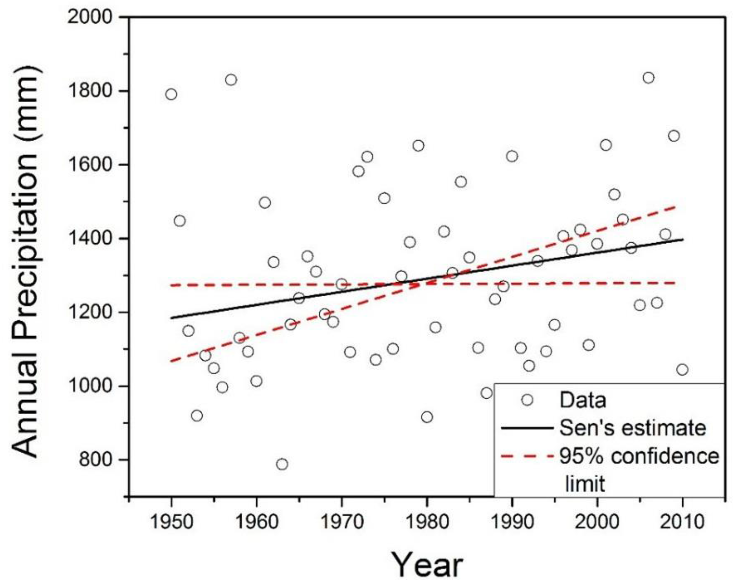
3.1. Precipitation

As indicated in Table 1, mean annual precipitation ranged from a low of 1080 mm for station Boyd (1) (Figure 2, station 6) to a high of 1352 mm for station Calloway (Figure 2, station 59) with a mean over all stations of 1224 ± 75 mm. Twenty-four stations’ series failed either the t-test, Ward’s test or both and were excluded from further analysis (Table 1) as non-homogeneous. Pre-whitening was necessary for only two of the remaining 60 stations (Boyd (2), Figure 2, station 7 with a serial correlation coefficient of 0.28 and Garrard (2), Figure 2, station 31 with a serial correlation coefficient of 0.21) and did not affect the detection of a significant trend. For the great majority (58% of 60%, or 97%) of the homogenous stations, no significant trends in annual precipitation were detected. In the two instances of significant trends, both trends were positive: Calloway, with a Sen slope of 3.51 mm/year (0.26% of the mean), and Carlisle (1) (Figure 2, station 60), with a Sen slope of 4.78 mm/year (0.37% of the mean). Figure 3 provides a more detailed depiction of the data for the Calloway County station, as an example, along with the calculated trend slope and 95% confidence limits on the slope. While it must be noted that the homogenization tests admit the possibility of a series with very low variability about a relatively large trend slope failing the tests, this appears not to have happened in this case. Only six of the 24 series assessed as non-homogenous would have had significant Sen slopes; however, the average of the six slope magnitudes was no greater than for the Calloway and Carlisle (1) stations.
Table 1. Summarized precipitation trend analysis results.
Station No.StationElevationMean Annual PrecipitationSen Slope
County(m)(mm)(mm/year)
1Allen (2)18912801.29 (−2.07–4.24) 1
2Allen (3)25913240.57 (−2.33–3.83)
3Ballard11312682.06 (−1.90–5.73)
4Bell (1)3481274−1.05 (−3.84–1.93)
5Bell (2)3541297−0.64 (−3.54–2.64)
6Boyd (1)17110802.12 (−0.43–4.16)
7Boyd (2)2261085−1.01 (−4.29–2.45)
8Boyle27412072.02 (−1.01–5.06)
9Breckinridge (1)11612062.27 (−0.85–5.37)
10Breckinridge (2)18012181.61 (−1.19–4.44)
11Breckinridge (3)21812002.79 (−0.66–6.08)
12Bullitt (1)16812381.36 (−1.66–4.16)
13Carlisle (2)12513263.41 (−0.41–6.25)
14Carlisle (3)10712912.99 (−0.41–5.88)
15Casey26513360.29 (−3.11–2.93)
16Christian (1)17112721.80 (−1.57–4.71)
17Christian (2)15912761.68 (−1.70–4.70)
18Clay (2)2651281−0.25 (−3.65–3.21)
19Clinton28413190.17 (−2.78–3.72)
20Cumberland1831293−0.42 (−3.92–2.53)
21Daviess (1)12311620.98 (−1.82–4.10)
22Daviess (2)12211561.52 (−1.21–4.59)
23Daviess (3)12511531.62 (−1.28–4.46)
24Edmonson (1)12513011.35 (−1.47–4.27)
25Edmonson (2)17713210.85 (−2.32–4.18)
26Edmonson (3)24112991.09 (−1.76–3.85)
27Fayette (1)29411580.60 (−2.69–3.83)
28Fayette (2)28411521.34 (−1.60–4.67)
29Franklin15211111.33 (−0.85–5.07)
30Garrard (1)3351225−1.05 (−4.31–2.41)
31Garrard (2)3111083−0.34 (−2.8 –2.38)
32Grant (1)28811081.09 (−1.58–3.34)
33Grant (2)28711050.08 (−2.78–2.64)
34Grant (3)28713091.64 (−1.93–4.59)
35Graves11013010.68 (−2.75–3.80)
36Grayson (2)14312342.60 (−0.24–5.75)
37Green (1)18013140.06 (−3.27–3.44)
38Green (2)21312671.04 (−2.32–3.44)
39Hancock12811832.05 (−0.56–5.00)
40Harrison (1)21311190.97 (−1.73–3.29)
41Harrison (2)22011250.80 (−2.16–3.27)
42Hopkins (2)13412172.70 (−0.26–5.44)
43Jackson38112431.78 (−4.93–1.49)
44Jefferson (1)22311931.60 (−1.49–4.64)
45Jefferson (2)14111282.05 (−0.72–4.94)
46Jessamine16511990.64 (−2.41–3.41)
47Knox3021282−0.39 (−3.60–2.64)
48Larue24012600.37 (−2.88–3.74)
49Laurel3841230−0.81 (−3.90–2.79)
50Madison3261189−1.06 (−3.93–2.48)
51Magoffin27711240.35 (−2.24–3.08)
52Owen29311220.48 (−2.20–2.97)
53Perry (2)3661236−0.77 (−3.47–2.14)
54Shelby22311872.68 (−0.28–5.98)
55Simpson22012361.38 (−2.05–4.54)
56Trigg11612902.29 (−1.40–5.29)
57Whitley (1)3231254−0.47 (−3.47–2.81)
58Wolfe30811690.33 (−2.50–3.35)
59Calloway16113523.51 (0.10–7.06) 2
60Carlisle (1)11012934.78 (0.73–8.42)
1 Values in parentheses are 95% confidence limits on the Sen slope; 2 Bold values represent significant at p = 0.05.
Figure 2. Spatial distribution of annual precipitation trend analysis results.
Climate 04 00010 g002
Figure 3. Annual precipitation with Sen slope estimate and 95% confidence intervals for the Calloway County, Kentucky, weather station.
Climate 04 00010 g003
The findings clearly indicate that, according to the dataset and methods used in this study, annual rainfall depths in Kentucky generally exhibit no statistically significant trends with respect to time. It is difficult to directly compare our findings to those from similar studies due to differences in data aggregation, trend detection methodology, and pre-processing technique (if any). Kentucky Climate Center [34] reports overall increasing trends in annual precipitation for three of the state’s four climate divisions (all except the easternmost), but an evaluation of the statistical significance of the trends is unavailable. In similar fashion, the online trend analysis tool available at [60] indicates positive trends in annual precipitation ranging from 0.9 mm/year (eastern Kentucky) to 2.5 mm/year (western Kentucky) for Kentucky’s four climate divisions when considering the same period of record as used in this study. This result is consistent with our findings in so far as the only stations identified in this study as having significant trends are in western Kentucky, the climate division having the highest trend as calculated by [60], but little else can be said. Larger-scale studies provide perhaps the best context for our findings. As described in the IPCC AR5 report [61], the Global Historical Climatology Network (GHCN), Global Precipitation Climatology Center (GPCC) [62] and Climatic Research Unit (CRU) datasets indicate positive—though not statistically significant—trends in annual precipitation for Kentucky. These data sets also indicate lower trend magnitudes in the eastern direction and higher magnitudes in the northern and (consistent with our findings) western directions, becoming statistically significant (p = 0.10) for grid points within 200–300 km north-northwest of Kentucky.
The two instances of significant trends in annual precipitation are noteworthy in the sense that (a) both are located in extreme southwestern Kentucky (the Mississippi Embayment physiographic region), (b) both have relatively high mean annual precipitation (the Calloway station has the highest among the stations studied, and Carlisle (1) has the 13th highest), (c) both stations are situated at relatively low elevations (Carlisle (1) is the second lowest and Calloway is the 13th lowest among the stations studied), and (d) the trend slopes are intermediate in comparison to what [44] reported for the Southern Coastal Plain region of North Carolina (a maximum of 9 mm/year), the findings published by [25] for the northeastern US (up to 0.13 mm/year) and the results from the GHCN, GPCC and CRU datasets as reported by [61]; i.e., within previously-reported bounds for the region. It thus seems possible that, instead of being anomalies or artifacts, the positively-trending stations might roughly mark the edge of a larger region of positively-trending annual precipitation. Analogous studies in the neighboring states, especially those to the north and west, would be required to explore this possibility more fully.

3.2. Temperature

As indicated in Table 2, 42 stations (50%) passed both the homogeneity tests. Mean annual temperature varied over these stations from 12.22 °C for the Shelby station (Figure 4, station 35) to 14.84 °C for the Calloway station (Figure 4, station 41), with an overall mean of 13.55 ± 0.66 °C. Pre-whitening was performed on eight of the 42 homogenous stations having serial correlation coefficients ranging from 0.32 to 0.42: Bell (1) (Figure 4, station 4), Clay (2) (Figure 4, station 15), Edmonson (3) (Figure 4, station 21), Garrard (1) (Figure 4, station 25), Grayson (3) (Figure 4, station 29), Simpson (Figure 4, station 36), Carlisle (2) (Figure 4, station 10) and Daviess (2) (Figure 4, station 20). Pre-whitening did not affect the statistical significance of subsequently-calculated trend slopes in any case. The general findings with regard to trends in the temperature series were similar to those reported earlier for precipitation: only a small proportion (3 of 42, or 7%) of the stations demonstrated a significant trend, though the trend in each case was in the increasing direction. Figure 5 provides an example of more detailed information for one of the stations having a positive trend in mean annual temperature (the Calloway station). As during the analysis precipitation data, trend slopes for series assessed as non-homogenous were examined to ensure that authentic non-homogeneities, rather than especially high trend slopes, were the reason for failing the homogeneity test(s). In all cases, the trend slopes of series assessed as non-homogenous were less than that for the homogenous Allen (2) station.
The data and analysis in the present study indicate that, broadly speaking, mean annual temperatures in Kentucky have not demonstrated a statistically significant trend with regard to time. The exceptions to this rule are the data from the Calloway, Allen (2) (Figure 4, station 40) and Jefferson (1) (Figure 4, station 42) stations. The Jefferson (1) station’s results (with an estimated trend slope of 0.01 °C/year) are difficult to interpret; the included city of Louisville could have been exerting an urban heat island effect on temperatures, but as a hypothesized explanation, this seems unsatisfactory given Louisville’s steadily declining population over the period 1960–2000 [63]. The other two stations having significant trends in mean annual temperature (Calloway at 0.01 °C/year and Allen (2) at 0.02 °C/year) seem not to have many relevant factors in common other than a non-urban dominant land-use and their location on or along Kentucky’s southern border.
The magnitudes of the positive trends in this study detected are consistent with results reported elsewhere in the world by [20] for China (1.52 °C over the last century) and by [21] for Sweden, to cite two examples. The existence of spatially-varied results over the scale investigated in this study is also consistent with findings published by [25], who found that comparably-sized regions with positive temperature trends and with no significant trends could exist within relatively short distances of one another. In closer proximity to our study area, [64] reported an overall cooling trend for the southeastern region of the United States for 1950–2006, but, at finer resolution, an increasing trend in daily maximum and minimum temperature along the western parts of Kentucky (consistent with the locations of the trends identified in this study as significant).
State-wide positive trends in temperature are identified by both [34] and [60] though, as discussed previously for these sources, the statistical significance of these trends is not assessed. A study reported by [65] using data from the period 1912–2011 indicates a slight (0.04 °C/century; statistically insignificant) increasing trend in state-wide temperatures. Comparable findings of positive, though statistically insignificant, trends are reported by [61] based on three datasets: the CRU’s HadCRUT4, the National Climatic Data Center (NCDC) Merged Land-Ocean Surface Temperature (MLOST), and the Goddard Institute for Space Studies (GISS) datasets. Results differ, however, when considering shorter, more recent periods of record. When considering only the period 1970–2012, [65] found a statistically significant trend of 0.02 °C/year state-wide, comparable to our findings for the Calloway, Allen (2) and Jefferson (1) stations. A very similar result is reported by [61] for the MLOST dataset over the period 1981–2012. Overall, the findings of the present study are consistent in many respects with others, including larger scale studies, but indicate an influence of data handling, selected period of record, and other factors on the results and inferences.
Table 2. Summarized temperature trend analysis results.
Station No.StationElevationMean Annual TemperatureSen Slope
County(m)(°C)(°C/year)
1Allen (1)21314.240.001 (−0.010–0.012)1
2Allen (3)25914.30−0.001 (−0.140–0.010)
3Ballard11314.260.004 (−0.006–0.015)
4Bell (1)34812.84−0.008 (−0.017–0.004)
5Bourbon24712.57−0.002 (−0.012–0.009)
6Breckinridge (1)11613.180.009 (−0.006–0.019)
7Breckinridge (2)18013.370.009 (−0.003–0.023)
8Breckinridge (3)21813.33−0.002 (−0.016–0.008)
9Carlisle (1)11014.49−0.001 (−0.010–0.009)
10Carlisle (2)12514.44−0.001 (−0.011–0.009)
11Carlisle (3)10714.480.002 (−0.007–0.011)
12Carroll13713.11−0.001 (−0.009–0.011)
13Casey26513.34−0.008 (−0.018–0.003)
14Christian (1)17114.290.008 (−0.009–0.009)
15Clay (2)26513.06−0.002 (−0.008–0.012)
16Clinton28413.56−0.005 (−0.003–0.019)
17Crittenden (1)11014.07−0.005 (−0.015–0.006)
18Crittenden (2)16514.210.003 (−0.017–0.007)
19Daviess (1)12314.060.000 (−0.008–0.011)
20Daviess (2)12213.810.001 (−0.009–0.010)
21Edmonson (3)24113.28−0.001 (−0.015–0.011)
22Fayette (1)29412.930.007 (−0.004–0.018)
23Fayette (2)28412.690.009 (−0.002–0.020)
24Fulton11614.54−0.000 (−0.005–0.020)
25Garrard (1)33513.250.004 (−0.009–0.015)
26Garrard (2)31113.200.003 (−0.008–0.014)
27Graves11014.600.006 (−0.005–0.025)
28Grayson (2)14313.14−0.003 (−0.016–0.009)
29Grayson (3)18313.410.005 (−0.006–0.014)
30Jessamine16513.010.004 (−0.009–0.015)
31Laurel38413.070.001 (−0.007–0.013)
32Madison32613.840.002 (−0.007–0.012)
33Perry (1)28512.800.007 (−0.003–0.019)
34Powell36613.130.000 (−0.010–0.011)
35Shelby22312.22−0.011 (−0.025–0.006)
36Simpson22014.120.003 (−0.008–0.013)
37Whitley (1)32313.23−0.002 (−0.010–0.011)
38Whitley (2)32613.09−0.010 (−0.020–0.000)
39Wolfe30812.80−0.002 (−0.009–0.011)
40Allen (2)18913.970.021 (0.010–0.030) 2
41Calloway16114.840.012 (0.001–0.020)
42Jefferson (1)22313.060.010 (0.001–0.019)
1 Values in parentheses are 95% confidence limits on the Sen slope; 2 Bold values represent significant at p = 0.05.
Figure 4. Spatial distribution of mean annual temperature trend analysis results.
Climate 04 00010 g004
Figure 5. Mean annual temperature with Sen slope estimate and 95% confidence intervals for the Calloway County, Kentucky, weather station.
Climate 04 00010 g005

4. Conclusions

This study of annual precipitation and mean annual temperature in the state of Kentucky indicates that, over the period 1950–2010, both of these variables generally (97% of the precipitation stations and 93% of the temperature stations) did not exhibit any statistically significant trends with respect to time. Should it hold true with the accumulation of more data, this finding can serve to simplify (or at least not to complicate) larger analyses that depend on this type of data as inputs, especially for the interior and eastern portions of the state. The relatively small number of significant trends detected, however, were all in the positive direction, and all were associated with weather stations very close to the borders of the state; these findings are comparable to those from larger-scale studies employing differing methods of analysis and periods of record. Similar studies involving weather stations from surrounding states will be required to more satisfactorily contextualize the occurrence of those positive trends in annual rainfall and mean annual temperature and to gain a broader understanding of how these variables are behaving on the larger regional scale.

Author Contributions

Somsubhra Chattopadhyay designed the study, collected and analyzed data while Dwayne R. Edwards contributed substantially to the interpretation of results and manuscript writing.

Conflicts of Interest

The authors declare no conflict of interest.

References

  1. Ficklin, D.L.; Stewart, I.T.; Maurer, E.P. Climate change impacts on streamflow and subbasin-scale hydrology in the Upper Colorado River Basin. PLoS ONE 2013, 8, e71297. [Google Scholar]
  2. Chattopadhyay, S.; Jha, M.K. Hydrological response due to projected climate variability in Haw River Watershed, North Carolina, USA. Hydrol. Sci. 2014. [Google Scholar] [CrossRef]
  3. Jin, X.; Sridhar, V. Impacts of climate change on hydrology and water resources in the Boise and Spokane River Basins. J. Am. Water Resour. Assoc. 2012, 48, 197–220. [Google Scholar] [CrossRef]
  4. Chattopadhyay, S.; Jha, M.K. Climate change impact on watershed hydrology: A comparison of three approaches. Am. J. Eng. Appl. Sci. 2014, 7, 122–128. [Google Scholar] [CrossRef]
  5. Modala, R. Assessing the Impact of Climate Change on Cotton Production in the Texas High Plains and Rolling Plains. Ph.D. Thesis, Texas A & M University, College Station, TX, USA, December 2014. [Google Scholar]
  6. Abdo, K.S.; Fiseha, B.M.; Rientjes, T.H.M.; Gieske, A.S.M.; Haile, A.T. Assessment of climate change impacts on the hydrology of Gilgel Abay catchment in Lake Tana Basin, Ethiopia. Hydrol. Processes 2009, 23, 3661–3669. [Google Scholar] [CrossRef]
  7. Neitsch, S.L.; Arnold, J.G.; Kiniry, J.R.; Williams, J.R. Soil and Water Assessment Tool, Theoretical Documentation: Version 2005; USDA Agricultural Research Service and Texas A & M Black Land Research Centre: Temple, TX, USA, 2005. [Google Scholar]
  8. Brutsaert, W.; Parlange, M.B. Hydrologic cycle explains the evaporation paradox. Nature 1998, 396. [Google Scholar] [CrossRef]
  9. Solomon, S.; Qin, D.; Manning, M.; Marquis, M.; Averyt, K.; Tignor, M.M.B.; Miller, H.L., Jr.; Chen, Z. Climate Change 2007: The Physical Science Basis; Cambridge University Press: Cambridge, UK, 2007; p. 996. [Google Scholar]
  10. Prudhomme, C.; Dorte, J.; Svensson, C. Uncertainty and climate change impact on the flood regime of small UK catchments. J. Hydrol. 2003, 277, 1–23. [Google Scholar] [CrossRef]
  11. Minville, M.; Brissette, F.; Leconte, R. Uncertainty of the impact of climate change on the hydrology of a Nordic watershed. J. Hydrol. 2008, 358, 70–83. [Google Scholar] [CrossRef]
  12. Boyles, P.R.; Raman, S. Analysis of climate trends in North Carolina (1949–1998). Environ. Int. 2003, 29, 263–275. [Google Scholar] [CrossRef]
  13. Prat, O.P.; Nelson, B.R. Characteristics of annual, seasonal, and diurnal precipitation in the Southeastern United States derived from long-term remotely sensed data. Atmos. Res. 2013, 144, 4–20. [Google Scholar] [CrossRef]
  14. New, M.; Todd, M.; Hulme, M.; Jones, P. Precipitation measurements and trends in the twentieth century. Int. J. Climatol. 2001, 21, 1899–1922. [Google Scholar] [CrossRef]
  15. Small, D.; Islam, S.; Vogel, R.M. Trends in precipitation and streamflow in the eastern US: Paradox or perception? Geophys. Res. Lett. 2006, 33. [Google Scholar] [CrossRef]
  16. Mohsin, T.; Gough, W.A. Trend analysis of long-term temperature time series in the greater Toronto Area. Theor. Appl. Climatol. 2010, 101, 311–327. [Google Scholar] [CrossRef]
  17. Sayemuzzaman, M.; Mekonnen, A.; Jha, M.K. Diurnal temperature range trend over North Carolina and the associated mechanisms, United States. Atmos. Res. 2015, 160, 99–108. [Google Scholar] [CrossRef]
  18. Sayemuzzaman, M.; Jha, M.K.; Mekonnen, A.; Schimmel, K.A. Subseasonal climate variability for North Carolina, United States. Atmos. Res. 2014, 145–146, 69–79. [Google Scholar] [CrossRef]
  19. IPCC. Climate Change 2013: The Physical Science Basis; Contribution of Working Group I to the Fifth Assessment Report of the Intergovernmental Panel on Climate Change; Stocker, T.F., Qin, D., Plattner, G.K., Tignor, M., Allen, S.K., Boschung, J., Nauels, A., Xia, Y., Bex, C., Midgley, P.M., Eds.; Cambridge University Press: Cambridge, UK, 2013; p. 1535. [Google Scholar]
  20. Zhao, P.; Jones, P.; Cao, L.; Yan, Z.; Zha, S.; Zhu, Y.; Yu, Y.; Tang, G. Trend of surface air temperature in Eastern China and associated large-scale climate variability over the last 100 years. Am. Meteorol. Soc. 2014, 27, 4693–4703. [Google Scholar] [CrossRef]
  21. Ceppi, P.; Scherrer, S.C.; Fischer, A.M.; Appenzeller, C. Revisiting Swiss temperature trends 1959–2008. Int. J. Climatol. 2012, 32, 203–213. [Google Scholar] [CrossRef]
  22. Rio, D.S.; Herrero, L.; Pinto-Gomes, C.; Penas, A. Spatial analysis of mean temperature trends in Spain over the period 1961–2006. Glob. Platin. Chang. 2011, 78, 65–75. [Google Scholar]
  23. Degaetano, T.A.; Allen, J.R. Trends in twentieth-century temperature extremes across the United States. J. Clim. 2002, 15, 3188–3205. [Google Scholar] [CrossRef]
  24. Martinez, J.C.; Maleski, J.J.; Miller, F.M. Trends in precipitation and temperature in Florida, USA. J. Hydrol. 2012, 452–453, 259–281. [Google Scholar] [CrossRef]
  25. Karmeshu, N. Trend Detection in Annual Temperature & Precipitation Using the Mann Kendall Test—A Case Study to Assess Climate Change on Select States in the Northeastern United States. Master’s Thesis, University of Pennsylvania, Philadelphia, PA, USA, August 2012. [Google Scholar]
  26. Xu, Z.X.; Takeuchi, K.; Ishidaira, H.; Li, J.Y. Long-term trend analysis for precipitation in Asia Pacific Friend river basin. Hydrol. Processes 2005, 19, 3517–3532. [Google Scholar] [CrossRef]
  27. IPCC. Climate Change 2001: The Scientific Basis; Contribution of Working Group I to the Third Assessment Report of the Intergovernmental Panel on Climate Change; Houghton, J.T., Ding, Y., Griggs, D.J., Noguer, M., van der Linden, P.J., Dai, X., Maskell, K., Johnson, C.A., Eds.; Cambridge University Press: Cambridge, UK, 2001. [Google Scholar]
  28. Karl, T.R.; Knight, R.W. Secular trends of precipitation amount, frequency, and intensity in the United States. Am. Meteorol. Soc. 1998, 79, 231–241. [Google Scholar] [CrossRef]
  29. Philandras, C.M.; Nastos, P.T.; Kapsomenakis, J.; Douvis, K.C.; Tselioudis, C.S.; Zerefos, C.S. Long term precipitation trends and variability within the Mediterranean region. Nat. Hazards Earth Syst. Sci. 2011, 11, 3235–3250. [Google Scholar] [CrossRef]
  30. Abbaspour, K.C.; Faramarzi, M.; Ghasemi, S.S.; Hong, Y. Assessing the impact of climate change on water resources in Iran. Water Resour. Res. 2009, 45. [Google Scholar] [CrossRef]
  31. Bocheva, L.; Marinova, T.; Simeonov, P.; Gospodinov, I. Variability and trends of extreme precipitation events over Bulgaria (1961–2005). Atmos. Res. 2008. [Google Scholar] [CrossRef]
  32. Longobardi, A.; Villani, P. Trend Analysis of annual and seasonal rainfall time series in the Mediterranean area. Int. J. Climatol. 2009. [Google Scholar] [CrossRef]
  33. Jones, R.J.; Schwartz, S.J.; Ellis, N.K.; Hathaway, M.J.; Jawdy, M.C. Temporal variability of precipitation in the Upper Tennesse Valley. J. Hydrol. 2015, 3, 125–138. [Google Scholar]
  34. Kentucky Climate Center. 2014—Kentucky Weather Year in Review. Available online: http://kyclimate.org/ (accessed on 6 April 2015).
  35. United States Department of Agriculture, Agricultural Research Service. Available online: http://www.ars.usda.gov/Research/docs.htm?docid=19440 (accessed on 10 April 2015).
  36. Aguilar, E.; Auer, I.; Brunet, M.; Peterson, T.C.; Wieringa, J. Guidelines on Climate Metadata and Homogenization; World Meteorological Organization: Geneva, Switzerland, 2003. [Google Scholar]
  37. Costa, A.C.; Soares, A. Homogenization of climate data: Review and new perspectives using geostatistics. Math. Geosci. 2009, 41, 291–305. [Google Scholar] [CrossRef]
  38. Panofsky, H.A.; Brier, G.W. Some Applications of Statistics to Meteorology; Pennsylvania State University: State College, PA, USA, 1968; p. 224. [Google Scholar]
  39. Alamgir, M.; Shahid, S.; Hazarika, M.; Nashrullah, S.; Harun, S.; Shamsudin, S. Analysis of meteorological drought pattern during different climate and cropping season in Bangladesh. J. Am. Water Resour. Assoc. 2015, 51, 794–806. [Google Scholar] [CrossRef]
  40. Kalkstein, L.S.; Tan, G.R.; Skindlov, J.A. An evaluation of clustering procedures for use in synoptic climatological classification. J. Clim. Appl. Meteorol. 1987, 26, 717–730. [Google Scholar] [CrossRef]
  41. Unal, Y.; Kindap, T.; Karaca, M. Redefining the climate zones of Turkey using cluster analysis. Int. J. Climatol. 2003, 23, 1045–1055. [Google Scholar] [CrossRef]
  42. Gocic, M.; Trajkovic, S. Analysis of changes in meteorological variables using Mann–Kendall and Sen’s slope estimator statistical tests in Serbia. Glob. Planet. Chang. 2013, 100, 172–182. [Google Scholar] [CrossRef]
  43. Sayemuzzaman, M.; Jha, M.K. Seasonal and annual precipitation time series trend analysis in North Carolina, United States. Atmos. Res. 2014, 137, 183–194. [Google Scholar] [CrossRef]
  44. Douglas, E.B.; Vogel, R.M.; Knoll, C.N. Trends in floods and low flows in the United States: Impact of serial correlation. J. Hydrol. 2000, 240, 90–105. [Google Scholar] [CrossRef]
  45. Zhang, X.; Harvey, K.D.; Hogg, W.D.; Yuzyk, T.R. Trends in Canadian streamflow. Water Resour. Res. 2001, 37, 987–998. [Google Scholar] [CrossRef]
  46. Yue, S.; Pilon, P.; Phinney, B.; Cavadias, G. The influence of autocorrelation on the ability to detect trend in hydrological series. Hydrol. Processes 2002, 16, 1807–1829. [Google Scholar] [CrossRef]
  47. Matalas, N.C.; Sankarasubramanian, A. Effect of persistence on trend detection via regression. Water Resour. Res. 2003, 39. [Google Scholar] [CrossRef]
  48. Wang, H.S.; Schubert, M.S.; Junye, C.; Martin, H.; Arun, K.; Pegion, P. Attribution of the seasonality and regionality in climate trends over the United States during 1950–2000. J. Clim. 2009, 22, 2571–2590. [Google Scholar] [CrossRef]
  49. Sonali, P.; Nagesh, K.D. Review of trend detection methods and their application to detect temperature changes in India. J. Hydrol. 2013, 476, 212–227. [Google Scholar] [CrossRef]
  50. Jha, M.K.; Singh, A.K. Trend analysis of extreme runoff events in major river basins of Peninsular Malaysia. Int. J. Water 2013, 7, 142–158. [Google Scholar] [CrossRef]
  51. Jain, S.K.; Kumar, V.; Saharia, M. Analysis of rainfall and temperature trends in northeast India. Int. J. Clim. 2012. [Google Scholar] [CrossRef]
  52. Modarres, R.; Silva, V. Rainfall trends in arid & semi-arid regions of Iran. J. Arid Environ. 2007, 70, 344–355. [Google Scholar]
  53. Tabari, H.; Somee, B.S.; Zadeh, M.R. Testing for long-term trends in climatic variables in Iran. Atmos. Res. 2011, 100, 132–140. [Google Scholar] [CrossRef]
  54. Sayemuzzaman, M.; Jha, M.K.; Mekonnen, A. Spatio-temporal long-term (1950–2009) temperature trend analysis in North Carolina, United States. Theor. Appl. Climatol. 2014, 120, 159–171. [Google Scholar] [CrossRef]
  55. Mann, H.B. Non-parametric tests against trend. Econometrica 1945, 13, 245–259. [Google Scholar] [CrossRef]
  56. Kendall, M.G. Rank Correlation Measures; Charles Griffin: London, UK, 1975. [Google Scholar]
  57. Modarres, R.; Sarhadi, A. Rainfall trends analysis of Iran in the last half of the twentieth century. J. Geophys. Res. 2009, 114. [Google Scholar] [CrossRef]
  58. Hirsch, R.M.; Slack, J.R.; Smith, R.A. Techniques of trend analysis for monthly water quality data. Water Resour. Res. 1982, 18, 107–121. [Google Scholar] [CrossRef]
  59. Salmi, T.; Maatta, A.; Anttila, P.; Ruoho-Airola, T.; Amnell, T. Detecting Trends of Annual Values of Atmospheric Pollutants by the Mann-Kendall Test and Sen’s Slope Estimates—The Excel Template Application MAKESENS; Finnish Meteorological Institute: Helsinki, Finland, 2002. [Google Scholar]
  60. National Center for Environmental Information Database. Available online: http://www.ncdc.noaa.gov/cag/ (accessed on 6 September 2015).
  61. Hartmann, D.L.; Tank, A.M.G.K.; Rusticucci, M.; Alexander, L.V.; Bronnimann, S.; Charabi, Y.; Dentener, F.J.; Dlugokencky, E.J.; Easterling, D.R.; Kaplan, A.; et al. Observations: Atmosphere and surface. In Climate Change 2013: The Physical Science Basis; Cambridge University Press: Cambridge, UK, 2013; pp. 159–255. [Google Scholar]
  62. Li, X.; Hu, Z.; Jiang, X.; Li, Y.; Gao, Z.; Yang, S.; Zhu, J.; Jha, B. Trend and seasonality of land precipitation in observations and CMIP5 model simulations. Int. J. Climatol. 2015. [Google Scholar] [CrossRef]
  63. Wachter, J. A 10-Year Perspective of the Merger of Louisville and Jefferson County, KY: Louisville Metro Vaults from 65th to 18th Largest City in the Nation; The Abell Foundation: Baltimore, MD, USA, 2013. [Google Scholar]
  64. Portmann, W.R.; Solomon, S.; Hegerl, C.G. Spatial and seasonal patterns in climate change, temperatures, and precipitation across the United States. Proc. Natl. Acad. Sci. USA 2009, 106, 7324–7329. [Google Scholar] [CrossRef] [PubMed]
  65. Tebaldi, C.; Adams-Smith, D.; Heller, N. The Heat is On: US Temperature Trends; Climate Central: Princeton, NJ, USA, 2012. [Google Scholar]

