Next Issue
Volume 4, March
Previous Issue
Volume 3, September


Fire, Volume 3, Issue 4 (December 2020) – 20 articles

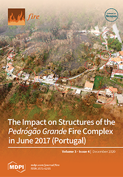
Cover Story (view full-size image): The most infamous wildfire in Portugal’s history ignited on June 17th, 2017, and raged through 45,000 hectares of land in Central Portugal, often with episodes of extreme fire behavior unlike anything the country had seen before. In the region of Pedrógão Grande, a total of 66 persons lost their lives, mostly trying to escape the flames, more than 250 were injured and over 1000 structures (including 263 residential homes) were damaged or destroyed, with direct losses estimated at around 200 million euros. The photograph shows a small village in the municipality of Castanheira de Pera, one of the most affected by this fire complex, highlighting the destruction in residential homes (circles), including one where an elderly couple lost their lives due to smoke inhalation (blue circle). View this paper
  • Issues are regarded as officially published after their release is announced to the table of contents alert mailing list.
  • You may sign up for e-mail alerts to receive table of contents of newly released issues.
  • PDF is the official format for papers published in both, html and pdf forms. To view the papers in pdf format, click on the "PDF Full-text" link, and use the free Adobe Reader to open them.
Order results
Result details
Section
Select all
Export citation of selected articles as:
17 pages, 1665 KiB  
Article
Building Loss in WUI Disasters: Evaluating the Core Components of the Wildland–Urban Interface Definition
by Michael D. Caggiano, Todd J. Hawbaker, Benjamin M. Gannon and Chad M. Hoffman
Fire 2020, 3(4), 73; https://doi.org/10.3390/fire3040073 - 20 Dec 2020
Cited by 36 | Viewed by 5595
Abstract
Accurate maps of the wildland–urban interface (WUI) are critical for the development of effective land management policies, conducting risk assessments, and the mitigation of wildfire risk. Most WUI maps identify areas at risk from wildfire by overlaying coarse-scale housing data with land cover [...] Read more.
Accurate maps of the wildland–urban interface (WUI) are critical for the development of effective land management policies, conducting risk assessments, and the mitigation of wildfire risk. Most WUI maps identify areas at risk from wildfire by overlaying coarse-scale housing data with land cover or vegetation data. However, it is unclear how well the current WUI mapping methods capture the patterns of building loss. We quantified the building loss in WUI disasters, and then compared how well census-based and point-based WUI maps captured the building loss. We examined the building loss in both WUI and non-WUI land-use types, and in relation to the core components of the United States Federal Register WUI definition: housing density, vegetation cover, and proximity to large patches of wildland vegetation. We used building location data from 70 large fires in the conterminous United States, which cumulatively destroyed 54,000 buildings from 2000 through to 2018. We found that: (1) 86% and 97% of the building loss occurred in areas designated as WUI using the census-based and point-based methods, respectively; (2) 95% and 100% of all of the losses occurred within 100 m and 850 m of wildland vegetation, respectively; and (3) WUI components were the most predictive of building loss when measured at fine scales. Full article
(This article belongs to the Special Issue Wildfire Hazard and Risk Assessment)
Show Figures

Figure 1

19 pages, 3824 KiB  
Article
The Post-Fire Assembly Processes of Tree Communities Based on Spatial Analysis of a Sierra Nevada Mixed-Conifer Forest
by Jelveh Tamjidi and James A. Lutz
Fire 2020, 3(4), 72; https://doi.org/10.3390/fire3040072 - 18 Dec 2020
Cited by 4 | Viewed by 2730
Abstract
Understanding the mechanisms underlying tree spatial arrangements may provide significant insights into the processes in the maintenance of species coexistence. We examined the potential role of habitat heterogeneity, dispersal limitation, negative density dependence, fire history, and unilateral intraspecific and interspecific interactions of adults [...] Read more.
Understanding the mechanisms underlying tree spatial arrangements may provide significant insights into the processes in the maintenance of species coexistence. We examined the potential role of habitat heterogeneity, dispersal limitation, negative density dependence, fire history, and unilateral intraspecific and interspecific interactions of adults on juveniles in shaping the spatial patterns of four dominant tree species (Abies concolor, Pinus lambertiana, Calocedrus decurrens, and Quercus kelloggii) after fire in the Yosemite Forest Dynamic Plot, California, USA. We used the univariate pair correlation function and implemented three point pattern processes (homogeneous Poisson process, inhomogeneous Poisson process, and homogeneous Thomas process) to evaluate the potential contributions of habitat filtering and dispersal limitation. We used a bivariate null model to evaluate unilateral intraspecific and interspecific interactions of adults on juveniles. We also used the pairwise correlation function to investigate the spatial patterns of density dependence. To understand the effect of fire, we used the univariate pair correlation function to investigate pattern changes during the six years following fire. We compared spatial pattern changes in both sprouting species (Quercus kelloggii) and seeding species (Abies concolor), and also examined the changes in patterns of large-diameter individuals of Abies concolor, Pinus lambertiana, and Calocedrus decurrens in 2013 (pre-fire), 2016 (two years post-fire), and 2019. Comparing the contributions of the homogeneous Thomas process and the inhomogeneous Poisson process at different spatial scales showed the importance of dispersal limitation and habitat heterogeneity at finer scales (0 m to 5 m) and coarser scales (5 m to 60 m), respectively, which suggests that the joint effects of dispersal limitation and habitat heterogeneity contribute to the spatial patterns of these three dominant tree species. Furthermore, the results showed that the young individuals of Abies concolor and Pinus lambertiana were more commonly found around the conspecific adults. Juvenile regeneration to the 1 cm diameter threshold was highly aggregated following the fire. Large-diameter trees of Abies concolor, Pinus lambertiana, and Calocedrus decurrens generally did not exhibit patterns different from complete spatial randomness (Calocedrus decurrens), or displayed only slight aggregation (Abies concolor and Pinus lambertiana). In addition, Abies concolor and Pinus lambertiana showed positive and negative conspecific density dependence in the immediate post-fire period, respectively. Full article
Show Figures

Figure 1

15 pages, 23357 KiB  
Article
Predicting Fire Propagation across Heterogeneous Landscapes Using WyoFire: A Monte Carlo-Driven Wildfire Model
by Cory W. Ott, Bishrant Adhikari, Simon P. Alexander, Paddington Hodza, Chen Xu and Thomas A. Minckley
Fire 2020, 3(4), 71; https://doi.org/10.3390/fire3040071 - 11 Dec 2020
Cited by 9 | Viewed by 4467
Abstract
The scope of wildfires over the previous decade has brought these natural hazards to the forefront of risk management. Wildfires threaten human health, safety, and property, and there is a need for comprehensive and readily usable wildfire simulation platforms that can be applied [...] Read more.
The scope of wildfires over the previous decade has brought these natural hazards to the forefront of risk management. Wildfires threaten human health, safety, and property, and there is a need for comprehensive and readily usable wildfire simulation platforms that can be applied effectively by wildfire experts to help preserve physical infrastructure, biodiversity, and landscape integrity. Evaluating such platforms is important, particularly in determining the platforms’ reliability in forecasting the spatiotemporal trajectories of wildfire events. This study evaluated the predictive performance of a wildfire simulation platform that implements a Monte Carlo-based wildfire model called WyoFire. WyoFire was used to predict the growth of 10 wildfires that occurred in Wyoming, USA, in 2017 and 2019. The predictive quality of this model was determined by comparing disagreement and agreement areas between the observed and simulated wildfire boundaries. Overestimation–underestimation was greatest in grassland fires (>32) and lowest in mixed-forest, woodland, and shrub-steppe fires (<−2.5). Spatial and statistical analyses of observed and predicted fire perimeters were conducted to measure the accuracy of the predicated outputs. The results indicate that simulations of wildfires that occurred in shrubland- and grassland-dominated environments had the tendency to over-predict, while simulations of fires that took place within forested and woodland-dominated environments displayed the tendency to under-predict. Full article
(This article belongs to the Special Issue Wildfire Hazard and Risk Assessment)
Show Figures

Figure 1

24 pages, 8858 KiB  
Article
Projected Impact of Mid-21st Century Climate Change on Wildfire Hazard in a Major Urban Watershed outside Portland, Oregon USA
by Andy McEvoy, Max Nielsen-Pincus, Andrés Holz, Arielle J. Catalano and Kelly E. Gleason
Fire 2020, 3(4), 70; https://doi.org/10.3390/fire3040070 - 8 Dec 2020
Cited by 10 | Viewed by 6119
Abstract
Characterizing wildfire regimes where wildfires are uncommon is challenged by a lack of empirical information. Moreover, climate change is projected to lead to increasingly frequent wildfires and additional annual area burned in forests historically characterized by long fire return intervals. Western Oregon and [...] Read more.
Characterizing wildfire regimes where wildfires are uncommon is challenged by a lack of empirical information. Moreover, climate change is projected to lead to increasingly frequent wildfires and additional annual area burned in forests historically characterized by long fire return intervals. Western Oregon and Washington, USA (westside) have experienced few large wildfires (fires greater than 100 hectares) the past century and are characterized to infrequent large fires with return intervals greater than 500 years. We evaluated impacts of climate change on wildfire hazard in a major urban watershed outside Portland, OR, USA. We simulated wildfire occurrence and fire regime characteristics under contemporary conditions (1992–2015) and four mid-century (2040–2069) scenarios using Representative Concentration Pathway (RCP) 8.5. Simulated mid-century fire seasons expanded in most scenarios, in some cases by nearly two months. In all scenarios, average fire size and frequency projections increased significantly. Fire regime characteristics under the hottest and driest mid-century scenarios illustrate novel disturbance regimes which could result in permanent changes to forest structure and composition and the provision of ecosystem services. Managers and planners can use the range of modeled outputs and simulation results to inform robust strategies for climate adaptation and risk mitigation. Full article
Show Figures

Figure 1

2 pages, 550 KiB  
Correction
Correction: Kouassi, J.-L.K., et al. Assessing the Impact of Climate Variability on Wildfires in the N’Zi River Watershed in Central Côte d’Ivoire. Fire 2018, 1, 36
by Jean-Luc Kouakou Kouassi, Narcisse Eboua Wandan and Cheikh Mbow
Fire 2020, 3(4), 69; https://doi.org/10.3390/fire3040069 - 6 Dec 2020
Viewed by 1816
Abstract
The authors wish to make the following corrections to this paper [...] Full article
Show Figures

Figure 3

17 pages, 3596 KiB  
Article
Determination of Firebrand Characteristics Using Thermal Videos
by Sergey Prohanov, Alexander Filkov, Denis Kasymov, Mikhail Agafontsev and Vladimir Reyno
Fire 2020, 3(4), 68; https://doi.org/10.3390/fire3040068 - 26 Nov 2020
Cited by 8 | Viewed by 3188
Abstract
Burning firebrands generated by wildland or prescribed fires may lead to the initiation of spot fires and fire escapes. At the present time, there are no methods that provide information on the thermal characteristics and number of such firebrands with high spatial and [...] Read more.
Burning firebrands generated by wildland or prescribed fires may lead to the initiation of spot fires and fire escapes. At the present time, there are no methods that provide information on the thermal characteristics and number of such firebrands with high spatial and temporal resolution. A number of algorithms have been developed to detect and track firebrands in field conditions in our previous study; however, each holds particular disadvantages. This work is devoted to the development of new algorithms and their testing and, as such, several laboratory experiments were conducted. Wood pellets, bark, and twigs of pine were used to generate firebrands. An infrared camera (JADE J530SB) was used to obtain the necessary thermal video files. The thermograms were then processed to create an annotated IR video database that was used to test both the detector and the tracker. Following these studies, the analysis showed that the Difference of Gaussians detection algorithm and the Hungarian tracking algorithm upheld the highest level of accuracy and were the easiest to implement. The study also indicated that further development of detection and tracking algorithms using the current approach will not significantly improve their accuracy. As such, convolutional neural networks hold high potential to be used as an alternative approach. Full article
Show Figures

Figure 1

26 pages, 9067 KiB  
Article
Towards the Development of a Probabilistic Approach to Informal Settlement Fire Spread Using Ignition Modelling and Spatial Metrics
by Antonio Cicione, Lesley Gibson, Colleen Wade, Michael Spearpoint, Richard Walls and David Rush
Fire 2020, 3(4), 67; https://doi.org/10.3390/fire3040067 - 15 Nov 2020
Cited by 10 | Viewed by 3711
Abstract
Large conflagrations of informal settlements occur regularly, leaving thousands of people homeless daily and taking tens of thousands of lives annually. Over the past few years, a large amount of data has been collected from a number of full-scale informal settlement fire experiments. [...] Read more.
Large conflagrations of informal settlements occur regularly, leaving thousands of people homeless daily and taking tens of thousands of lives annually. Over the past few years, a large amount of data has been collected from a number of full-scale informal settlement fire experiments. This paper uses that data with a semi-probabilistic fire model previously proposed by the authors, to illustrate the potential applications of the fire spread method proposed. The current model is benchmarked against a 20-dwelling full-scale informal settlement fire experiment, and the effects of the (a) ignition criteria, (b) wind direction, and (c) wind speeds on the predicted fire spread rates are investigated through the use of a parametric study. Colour maps of the fire spread rates and patterns are then used to visually interpret the effects of different types of fire scenarios and fire breaks. Finally, the fire spread capability within B-RISK is used to derive a linear equation for the potential fire spread rate as a function of the settlement spatial metrics (e.g., density and distance to nearest neighbour). To further illustrate the potential application of this work, the fire spread rate equation is then applied across the whole of Cape Town, South Africa, to show the 10 informal settlement areas most at “risk” of large conflagrations. Full article
Show Figures

Figure 1

9 pages, 1307 KiB  
Brief Report
Developing Behavioral and Evidence-Based Programs for Wildfire Risk Mitigation
by Hilary Byerly, James R. Meldrum, Hannah Brenkert-Smith, Patricia Champ, Jamie Gomez, Lilia Falk and Chris Barth
Fire 2020, 3(4), 66; https://doi.org/10.3390/fire3040066 - 11 Nov 2020
Cited by 3 | Viewed by 4004
Abstract
The actions of residents in the wildland–urban interface can influence the private and social costs of wildfire. Wildfire programs that encourage residents to take action are often delivered without evidence of effects on behavior. Research from the field of behavioral science shows that [...] Read more.
The actions of residents in the wildland–urban interface can influence the private and social costs of wildfire. Wildfire programs that encourage residents to take action are often delivered without evidence of effects on behavior. Research from the field of behavioral science shows that simple, often low-cost changes to program design and delivery can influence socially desirable behaviors. In this research report, we highlight how behavioral science and experimental design may advance efforts to increase wildfire risk mitigation on private property. We offer an example in which we tested changes in outreach messaging on property owners’ interest in wildfire risk information. In partnership with a regional wildfire organization, we mailed 4564 letters directing property owners to visit personalized wildfire risk webpages. By tracking visitation, we observed that 590 letter recipients (12%) sought information about their wildfire risk and response varied by community. This research–practice collaboration has three benefits: innovation in outreach, evidence of innovation through experimental design, and real impacts on interest in wildfire mitigation among property owners. Future collaborations may inform behavioral and evidence-based programs to better serve residents and the public interest as the risks from wildfires are projected to grow. Full article
Show Figures

Figure 1

10 pages, 3574 KiB  
Perspective
Selective Shrub Management to Preserve Mediterranean Forests and Reduce the Risk of Fire: The Case of Mainland Portugal
by Mauro A.M. Raposo, Carlos J. Pinto Gomes and Leonel J.R. Nunes
Fire 2020, 3(4), 65; https://doi.org/10.3390/fire3040065 - 10 Nov 2020
Cited by 14 | Viewed by 3821
Abstract
The recurrent rural fires that occur annually in Portugal have reached great proportions due to a lack of effective landscape management. Attempts to solve this problem led to the legal imposition to cut back the vegetation in the fuel management areas, which has [...] Read more.
The recurrent rural fires that occur annually in Portugal have reached great proportions due to a lack of effective landscape management. Attempts to solve this problem led to the legal imposition to cut back the vegetation in the fuel management areas, which has had a negative effect on biodiversity. National legislation protects three native plant species (Quercus suber, Q. rotundifolia and Ilex aquifolium). European legislation, through the Habitats Directive, also identifies some plant species that require strict protection, although it leaves out several endemic and rare plants. In this work we aim to differentiate the types of shrub plant material and their pyrophilic behavior, since the physical and chemical characteristics of vegetation can enhance or inhibit the progression of fire. Thus, based on phytosociological science, specifically at the class level, the dynamics of potential climatophilous vegetation in Portugal are presented and the classes that should be prioritized for control are identified. Based on ecology, it was possible to identify morphological patterns of vegetation. In short, the genera targeted for control under the National Forest Fire Protection Plan belong to the furthest states from the mature potential of a forest, generally consisting of heliophile shrubs and typically growing in degraded soils. The shrub species to be valued belong to dynamic states closer to the mature potential, consisting mainly of broad-leaved shrubs and those growing in better-preserved soils. Full article
Show Figures

Figure 1

8 pages, 1568 KiB  
Communication
Assessing the Relationship between Litter + Duff Consumption and Post-Fire Soil Temperature Regimes
by Crystal N. Smith and Donald L. Hagan
Fire 2020, 3(4), 64; https://doi.org/10.3390/fire3040064 - 8 Nov 2020
Cited by 1 | Viewed by 2997
Abstract
The immediate effects of wildland fire on soil have been well documented. However, we know much less about the longer-term effects and their implications for plants. Post-fire soil temperature regimes, for example, have received relatively little research attention, despite potential effects on plant [...] Read more.
The immediate effects of wildland fire on soil have been well documented. However, we know much less about the longer-term effects and their implications for plants. Post-fire soil temperature regimes, for example, have received relatively little research attention, despite potential effects on plant phenology and establishment. Using portable temperature datalogger units (iButtons), we conducted an experimental study to assess how fire severity (measured in terms of litter and duff consumption) influences biologically relevant temperature parameters such as diel minimums, maximums, means, and ranges. We also used these data to calculate cumulative soil growing degree days (GDDs). The study was conducted during the early to mid-spring to capture the transition from dormant season to growing season. Results indicate that mean and max soil temperatures increase in the weeks after fire, with the most pronounced effects in the higher severity treatments. By the end of the 40-day study period, soils in the high severity burn treatment had accumulated 72 GDDs, compared to 17.9, 13.6, and 1.4 in moderate, low, and control treatments, respectively. These findings indicate that fire severity has significant and persistent effects on post-fire soil temperature regimes, and this likely has implications for the post-fire vegetation response. Full article
Show Figures

Figure 1

53 pages, 1987 KiB  
Article
Evaluating Socioecological Wildfire Effects in Greece with a Novel Numerical Index
by Palaiologos Palaiologou, Kostas Kalabokidis, Michelle A. Day and Vasilis Kopsachilis
Fire 2020, 3(4), 63; https://doi.org/10.3390/fire3040063 - 6 Nov 2020
Cited by 8 | Viewed by 4558
Abstract
Large-scale wildfires have become more frequent in Greece and coupled with the country’s limited economic resources, investments in both pre-fire planning and post-fire rehabilitation for most affected areas are not feasible. From the perspective of forest and fire management agencies, the severity and [...] Read more.
Large-scale wildfires have become more frequent in Greece and coupled with the country’s limited economic resources, investments in both pre-fire planning and post-fire rehabilitation for most affected areas are not feasible. From the perspective of forest and fire management agencies, the severity and importance of fire effects are evaluated based only on total area burned, while from a societal standpoint, by the number of fatalities and destroyed houses. A holistic approach to rank wildfires with an inclusive assessment of all their effects is missing. We developed a new evaluation and ranking index based on expert judgment, the study of 50 large-scale fire events in Greece and a detailed review of the literature, to develop a set of categories and criteria to assess ecological and socioeconomic effects of wildfires. The Fire Inventory and Ranking of Effects (FIRE) Index provides a comprehensive and easy-to-use semi-numeric framework that combines scores from seven fire effects categories and 56 criteria through a user-friendly web-platform. The seven categories include fire effects on landscape and vegetation, general environmental impacts, regeneration potential and vegetation recovery, casualties and fatalities, destruction and damages to infrastructure, economic losses, and firefighting and wildfire suppression. Each of the 56 criteria within these categories describes a different anticipated fire effect. The magnitude of each fire effect criterion is estimated by predefined ranked choices by one or more persons/assessors in a multi-level evaluation procedure. We apply the FIRE Index assessment to a significant 5900-ha wildfire that occurred in 2011 in northern Greece, including a sensitivity analysis of how different category weights impact the final index score. More diverse metrics to assess wildfire effects will help address the complex social and biophysical dimensions of the wildfire governance challenge and help guide pre- and post-fire management actions. Full article
Show Figures

Graphical abstract

17 pages, 25898 KiB  
Article
Anthropogenic Fires in West African Landscapes: A Spatially Explicit Model Perspective of Humanized Savannas
by Sébastien Caillault, Paul Laris, Cyril Fleurant, Daniel Delahaye and Aziz Ballouche
Fire 2020, 3(4), 62; https://doi.org/10.3390/fire3040062 - 4 Nov 2020
Cited by 6 | Viewed by 2700
Abstract
Fire regimes are important components of environmental dynamics, but our understanding of them is limited. Despite recent advances in the methodologies used to remotely sense and map fires and burned areas and new case studies that shed light on local fire use and [...] Read more.
Fire regimes are important components of environmental dynamics, but our understanding of them is limited. Despite recent advances in the methodologies used to remotely sense and map fires and burned areas and new case studies that shed light on local fire use and management practices, the scientific community still has much to learn about anthropogenic fire regimes. We identify two areas for improvement: first, the fine-scale heterogeneity of fire dynamics for specific regions is often masked by global-scale approaches, and second, barriers between the disciplines focusing on fire impacts hamper the development of knowledge of the human dimensions of fire regimes. To address the “blind spot” that these limitations create, we present a simple dynamic model of fire ignition in savanna systems. The aim is to connect the local and global scales of fire regimes by focusing on human fire management (anthropogenic fire). Our dynamical model is based on a study area in Western Burkina Faso and integrates biophysical elements (climate and soil data), land cover, and fire management scenarios based on field surveys. The simulation results offer contrasting views of the impact of local fire management practices on regional fire regimes observed in savannas. Fire density and frequency are local variables that clearly change the fire regimes despite a complex and constrained biophysical system. This experience, drawing from fieldwork and modelling, may be a way to integrate some key aspects of anthropogenic fire research in savanna systems. Full article
Show Figures

Figure 1

15 pages, 4872 KiB  
Article
Experimental Investigation of the Effect of Heat Flux on the Fire Behavior of Engineered Wood Samples
by Denis Kasymov, Mikhail Agafontsev, Vladislav Perminov, Pavel Martynov, Vladimir Reyno and Egor Loboda
Fire 2020, 3(4), 61; https://doi.org/10.3390/fire3040061 - 29 Oct 2020
Cited by 7 | Viewed by 3138
Abstract
This paper presents the experimental study results on the effect of heat flux emitted by a standard source on the charring and ignition characteristics of wood construction materials (plywood, chipboard, and oriented strand board) using infrared thermography (IRT) in the narrow spectral ranges [...] Read more.
This paper presents the experimental study results on the effect of heat flux emitted by a standard source on the charring and ignition characteristics of wood construction materials (plywood, chipboard, and oriented strand board) using infrared thermography (IRT) in the narrow spectral ranges of infrared wavelength. The time to ignition (TTI), charring rate and depth were obtained for the samples. In addition, the effect of several fire retardants on the charring rate and depth of the samples and TTI was analyzed. All fire retardants contribute to an increase in TTI, which confirms their main function—fire protection. However, the effect of fire retardants differs noticeably depending on the material. A new experimental technique is suggested, with the infrared imaging of the temperature distribution along the end of a sample under the heat flux effect on its frontal surface. The uniqueness of this approach consists in the registration of the entire process of ignition and combustion of the presented materials, which occurs in real time without contact with high spatial and temporal resolution. Using the infrared camera of the research class, it becomes possible to record the entire process from the occurrence of the temperature exposure region to the deep carbonized crater in the body of the material. The results can serve as additional recommendations in the development of fire hazard testing methods for construction materials and fire retardants. Full article
Show Figures

Graphical abstract

17 pages, 3539 KiB  
Article
Verification of Red Flag Warnings across the Northwestern U.S. as Forecasts of Large Fire Occurrence
by Joshua Clark, John T. Abatzoglou, Nicholas J. Nauslar and Alistair M.S. Smith
Fire 2020, 3(4), 60; https://doi.org/10.3390/fire3040060 - 20 Oct 2020
Cited by 3 | Viewed by 3794
Abstract
Red Flag Warnings (RFWs) issued by the National Weather Service in the United States (U.S.) are an important early warning system for fire potential based on forecasts of critical fire weather that promote increased fire activity, including the occurrence of large fires. However, [...] Read more.
Red Flag Warnings (RFWs) issued by the National Weather Service in the United States (U.S.) are an important early warning system for fire potential based on forecasts of critical fire weather that promote increased fire activity, including the occurrence of large fires. However, verification of RFWs as they relate to fire activity is lacking, thereby limiting means to improve forecasts as well as increase value for end users. We evaluated the efficacy of RFWs as forecasts of large fire occurrence for the Northwestern U.S.—RFWs were shown to have widespread significant skill and yielded an overall 124% relative improvement in forecasting large fire occurrences than a reference forecast. We further demonstrate that the skill of RFWs is significantly higher for lightning-ignited large fires than for human-ignited fires and for forecasts issued during periods of high fuel dryness than those issued in the absence of high fuel dryness. The results of this first verification study of RFWs related to actualized fire activity lay the groundwork for future efforts towards improving the relevance and usefulness of RFWs and other fire early warning systems to better serve the fire community and public. Full article
Show Figures

Figure 1

15 pages, 7907 KiB  
Article
Terrestrial Image-Based Point Clouds for Mapping Near-Ground Vegetation Structure: Potential and Limitations
by Luke Wallace, Bryan Hally, Samuel Hillman, Simon D. Jones and Karin Reinke
Fire 2020, 3(4), 59; https://doi.org/10.3390/fire3040059 - 19 Oct 2020
Cited by 5 | Viewed by 2563
Abstract
Site-specific information concerning fuel hazard characteristics is needed to support wildfire management interventions and fuel hazard reduction programs. Currently, routine visual assessments provide subjective information, with the resulting estimate of fuel hazard varying due to observer experience and the rigor applied in making [...] Read more.
Site-specific information concerning fuel hazard characteristics is needed to support wildfire management interventions and fuel hazard reduction programs. Currently, routine visual assessments provide subjective information, with the resulting estimate of fuel hazard varying due to observer experience and the rigor applied in making assessments. Terrestrial remote sensing techniques have been demonstrated to be capable of capturing quantitative information on the spatial distribution of biomass to inform fuel hazard assessments. This paper explores the use of image-based point clouds generated from imagery captured using a low-cost compact camera for describing the fuel hazard within the surface and near-surface layers. Terrestrial imagery was obtained at three distances for five target plots. Subsets of these images were then processed to determine the effect of varying overlap and distribution of image captures. The majority of the point clouds produced using this image-based technique provide an accurate representation of the 3D structure of the surface and near-surface fuels. Results indicate that high image overlap and pixel size are critical; multi-angle image capture is shown to be crucial in providing a representation of the vertical stratification of fuel. Terrestrial image-based point clouds represent a viable technique for low cost and rapid assessment of fuel structure. Full article
Show Figures

Graphical abstract

17 pages, 7075 KiB  
Article
Fire Activity in Mediterranean Forests (The Algerian Case)
by Thomas Curt, Aissa Aini and Sylvain Dupire
Fire 2020, 3(4), 58; https://doi.org/10.3390/fire3040058 - 30 Sep 2020
Cited by 7 | Viewed by 5858
Abstract
Algeria has high wildfire activity, albeit restricted to the northern coastal fringe. However, no study has investigated why fire is restricted to that area, and what combination of factors explains the occurrence of wildfires. Here, we describe the current fire regime of Northern [...] Read more.
Algeria has high wildfire activity, albeit restricted to the northern coastal fringe. However, no study has investigated why fire is restricted to that area, and what combination of factors explains the occurrence of wildfires. Here, we describe the current fire regime of Northern Algeria from 2000 to 2019 and we correlate fire activity to a range of environmental and anthropic drivers. We found a strong north–south gradient in fire occurrence: it is maximal in the high-fueled (productive) oak forests of Northern Algeria with high annual rainfall amount, whereas it is fuel-limited in the South due to semi-arid conditions. We determined that fire is nearly absent where the bioclimate is subarid or arid, due to the steppic vegetation with summer Normalized Difference Vegetation Index (NDVI) values below 0.35. Therefore, fire occupies a narrow niche in space (the humid and subhumid areas with high productivity) and in time as most fires occur in summer after the high rainfalls from fall to spring that promote fuel growth. Humans also play a role as fire hotspots are concentrated in croplands and in built-up areas with high human density and infrastructures mixed with shrublands and forests. We discuss how the ongoing climate changes and the desertification progressing towards the North of Algeria may finally restrict forests to a narrow fringe providing less and less ecological services to the Algerian people. Full article
Show Figures

Figure 1

22 pages, 4309 KiB  
Article
The Impact on Structures of the Pedrógão Grande Fire Complex in June 2017 (Portugal)
by Luís M. Ribeiro, André Rodrigues, Davi Lucas and Domingos Xavier Viegas
Fire 2020, 3(4), 57; https://doi.org/10.3390/fire3040057 - 29 Sep 2020
Cited by 34 | Viewed by 6982
Abstract
On 17 June 2017, one of the most dramatic and destructive wildfires in Portugal’s History started, formed by a complex of at least five wildfires that merged together burning more than 45,000 hectares. In its aftermath, 66 persons lost their lives, most of [...] Read more.
On 17 June 2017, one of the most dramatic and destructive wildfires in Portugal’s History started, formed by a complex of at least five wildfires that merged together burning more than 45,000 hectares. In its aftermath, 66 persons lost their lives, most of them trying to run away from the fire, more than 250 were injured, and over 1000 structures (including 263 residential homes) were damaged or destroyed, with direct losses estimated at around 200 million euros. Shortly after the fire was extinguished, and as part of a larger analysis, the authors performed exhaustive field work to assess the fire impact on all manmade structures in the area of the Pedrógão Grande fire. A specific geodatabase was built, accounting for an extensive set of parameters aimed at characterizing: (i) The structure, (ii) the surroundings of the structure, and (iii) the arrival and impact of the fire. A total of 1043 structures were considered for the analysis, mostly support structures, like sheds or storage (38.6%), but also around 25% of dwellings (13.3% primary and 11.9% secondary). Regarding the ignitions, more than 60% of the structures were ignited due to the deposition of firebrands in different weak points. In addition, more than 60% of these ignitions occurred on the roofs, mainly because of the vulnerability associated with the structures and materials supporting them. Despite these results, and from what we observed on the structures that were not destroyed, we still consider that for the Portuguese reality houses are a good refuge, providing that they and their surroundings are managed and kept in good conditions. Full article
Show Figures

Graphical abstract

14 pages, 8158 KiB  
Article
Drought Increases Vulnerability of Pinus ponderosa Saplings to Fire-Induced Mortality
by Raquel Partelli-Feltrin, Daniel M. Johnson, Aaron M. Sparks, Henry D. Adams, Crystal A. Kolden, Andrew S. Nelson and Alistair M. S. Smith
Fire 2020, 3(4), 56; https://doi.org/10.3390/fire3040056 - 28 Sep 2020
Cited by 13 | Viewed by 5376
Abstract
The combination of drought and fire can cause drastic changes in forest composition and structure. Given the predictions of more frequent and severe droughts and forecasted increases in fire size and intensity in the western United States, we assessed the impact of drought [...] Read more.
The combination of drought and fire can cause drastic changes in forest composition and structure. Given the predictions of more frequent and severe droughts and forecasted increases in fire size and intensity in the western United States, we assessed the impact of drought and different fire intensities on Pinus ponderosa saplings. In a controlled combustion laboratory, we exposed saplings to surface fires at two different fire intensity levels (quantified via fire radiative energy; units: MJ m−2). The recovery (photosynthesis and bud development) and mortality of saplings were monitored during the first month, and at 200- and 370-days post-fire. All the saplings subjected to high intensity surface fires (1.4 MJ m−2), regardless of the pre-fire water status, died. Seventy percent of pre-fire well-watered saplings recovered after exposure to low intensity surface fire (0.7 MJ m−2). All of the pre-fire drought-stressed saplings died, even at the lower fire intensity. Regardless of the fire intensity and water status, photosynthesis was significantly reduced in all saplings exposed to fire. At 370 days post-fire, burned well-watered saplings that recovered had similar photosynthesis rates as unburned plants. In addition, all plants that recovered or attempted to recover produced new foliage within 35 days following the fire treatments. Our results demonstrate that the pre-fire water status of saplings is an important driver of Pinus ponderosa sapling recovery and mortality after fire. Full article
Show Figures

Figure 1

9 pages, 1255 KiB  
Article
Diurnal Pine Bark Structure Dynamics Affect Properties Relevant to Firebrand Generation
by Scott Pokswinski, Michael R. Gallagher, Nicholas S. Skowronski, E. Louise Loudermilk, Joseph J. O’Brien and J. Kevin Hiers
Fire 2020, 3(4), 55; https://doi.org/10.3390/fire3040055 - 25 Sep 2020
Cited by 5 | Viewed by 2893
Abstract
Firebrands are an important agent of wildfire spread and structure fire ignitions at the wildland urban interface. Bark flake morphology has been highlighted as an important yet poorly characterized factor in firebrand generation, transport, deposition, and ignition of unburned material. Using pine species [...] Read more.
Firebrands are an important agent of wildfire spread and structure fire ignitions at the wildland urban interface. Bark flake morphology has been highlighted as an important yet poorly characterized factor in firebrand generation, transport, deposition, and ignition of unburned material. Using pine species where bark flakes are the documented source of embers, we conducted experiments to investigate how bark structure changes in response to diurnal drying. Over a three-day period in a longleaf pine (Pinus palustris Mill.) stand in Florida, we recorded changes in temperature, moisture content, and structure of bark across different facing aspects of mature pine trees to examine the effects of varying solar exposure on bark moisture. We further compared results to bark drying in a pitch pine (Pinus rigida Mill.) plantation in New Jersey. Under all conditions, bark peeled and lifted away from the tree trunk over the study periods. Tree bole aspect and the time of day interacted to significantly affect bark peeling. General temperature increases and moisture content decreases were significantly different between east and west aspects in pitch pine, and with time of day and aspect in longleaf pine. These results illustrate that bark moisture and flakiness is highly dynamic on short time scales, driven largely by solar exposure. These diurnal changes likely influence the probability of firebrand production during fire events via controls on moisture (ignition) and peeling (lofting). Full article
Show Figures

Figure 1

19 pages, 4151 KiB  
Article
Soil Enzyme Activity and Soil Nutrients Jointly Influence Post-Fire Habitat Models in Mixed-Conifer Forests of Yosemite National Park, USA
by Jelveh Tamjidi and James A. Lutz
Fire 2020, 3(4), 54; https://doi.org/10.3390/fire3040054 - 23 Sep 2020
Cited by 2 | Viewed by 2863
Abstract
Disentangling the relative importance of habitat filtering and dispersal limitations at local scales (<1 km2) in shaping species composition remains an important question in community ecology. Previous studies have examined the relative importance of these mechanisms using topography and selected soil [...] Read more.
Disentangling the relative importance of habitat filtering and dispersal limitations at local scales (<1 km2) in shaping species composition remains an important question in community ecology. Previous studies have examined the relative importance of these mechanisms using topography and selected soil properties. We examined both topography and edaphic properties from 160 locations in the recently burned 25.6 ha Yosemite Forest Dynamics Plot (YFDP) in Yosemite National Park, California, USA. In addition to eight soil chemical properties, we included phosphatases and urease enzymes in a definition of habitat niches, primarily because of their rapid changes with fire (compared to soil nutrients) and also their role in ecosystem function. We applied environmental variables to the distributions of 11 species. More species–habitat associations were defined by soil properties (54.5%) than topographically-defined habitat (45.4%). We also examined the relative importance of spatial and environmental factors in species assemblage. Proportions explained by spatial and environmental factors differed among species and demographic metrics (stem abundance, basal area increment, mortality, and recruitment). Spatial factors explained more variation than environmental factors in stem abundance, mortality, and recruitment. The contributions of urease and acid phosphatase to habitat definition were significant for species abundance and basal area increment. These results emphasize that a more complete understanding of niche parameters is needed beyond simple topographic factors to explain species habitat preference. The stronger contribution of spatial factors suggests that dispersal limitation and unmeasured environmental variables have high explanatory power for species assemblage in this coniferous forest. Full article
Show Figures

Figure 1

Previous Issue
Next Issue
Back to TopTop