Prediction of Reservoir Quality from Log-Core and Seismic Inversion Analysis with an Artificial Neural Network: A Case Study from the Sawan Gas Field, Pakistan


Abstract
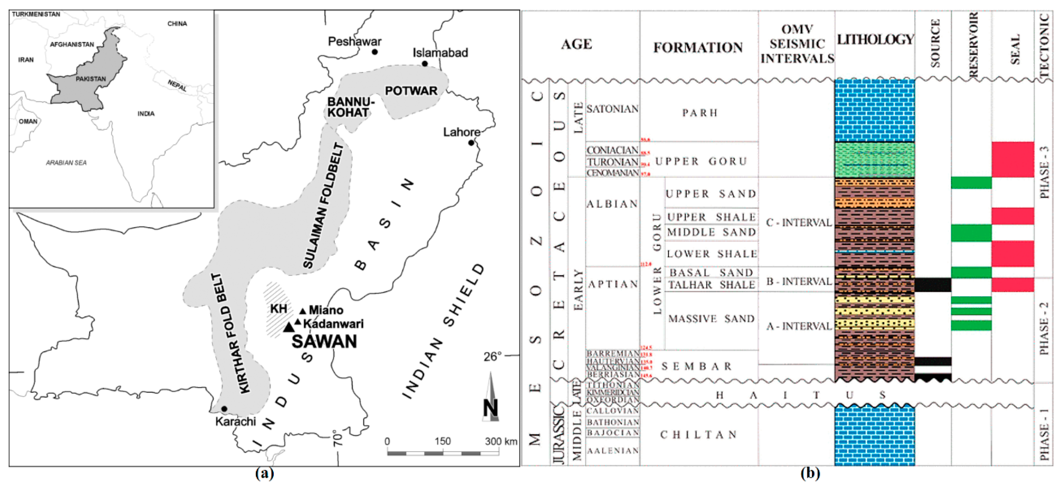
:1. Introduction
2. Materials and Methods
2.1. Reservoir Parameters Estimation
2.2. Support Vector Machine
- (a)
- Select a set of the appropriate seismic attribute after examineing the seismic and well log data at well locations.
- (b)
- Considering a logical relationship between suitable seismic attributes and the reservoir characters by linear or non-linear algorithms.
- (c)
- Train the data until maximizing the correlation coefficient between original and synthetic AI. If the correlation is high, then apply the selected parameters information to a seismic cube and generate a cube or volume of a specific reservoir property.
- (d)
- The AI model was developed to extract the petrophysical properties from seismic amplitude reflection. The results obtained from inversion was interpreted and cross-examined with other geological features to assess a prospect.
3. Results and Discussion
3.1. Reservoir Characterization from Logs and Core
3.1.1. Petrographic and SEM Image Analysis
3.1.2. NMR Investigation of the Cores and SEM Image Analysis
3.1.3. Facies Analysis and Modeling
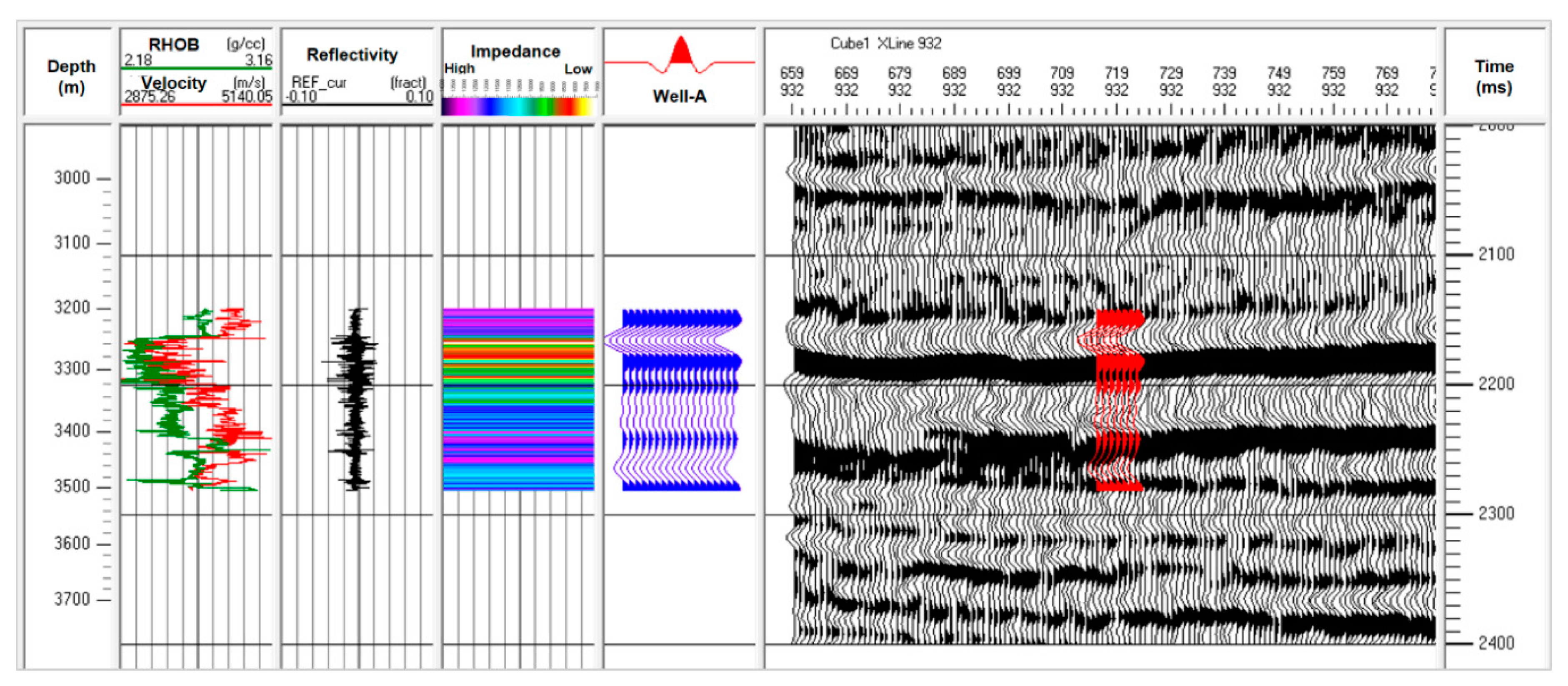
3.2. Reservoir Characterization from Seismic Data
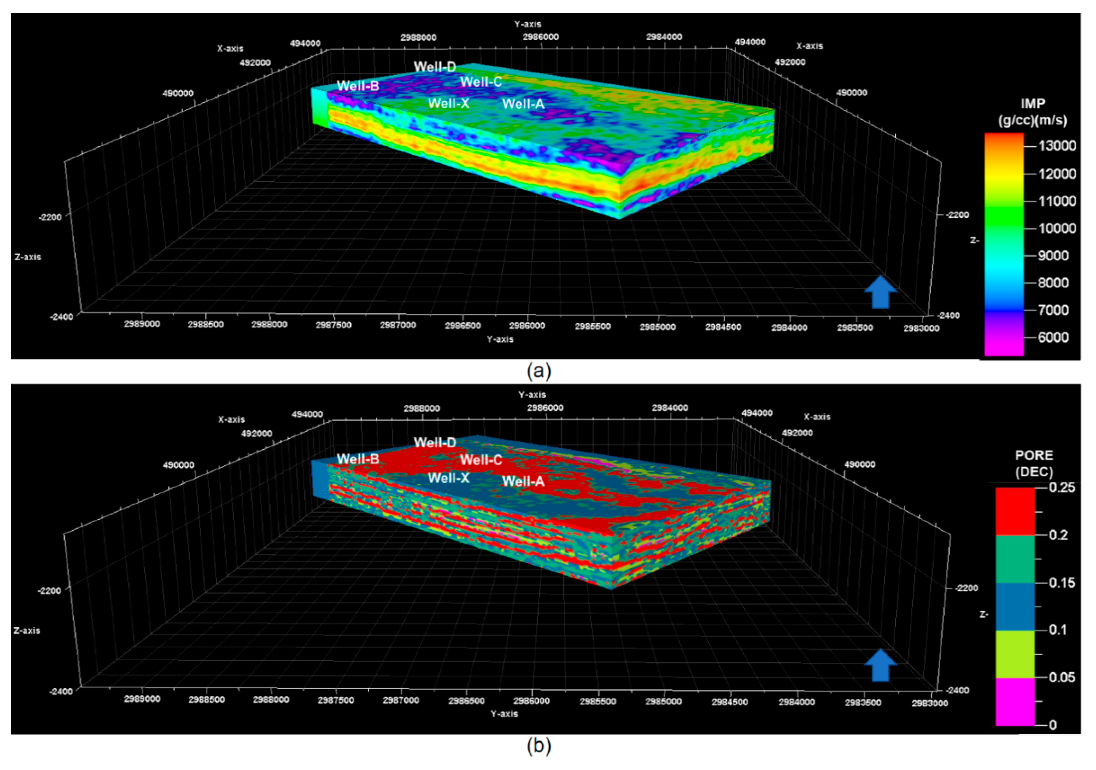
3.2.1. Seismic Inversion
3.2.2. Reservoir Character (Porosity) Estimation
3.2.3. Integrated Petrophysical Data Interpretation
4. Prediction of Reservoir Quality
5. Conclusions
Author Contributions
Funding
Acknowledgments
Conflicts of Interest
Acronyms
| AI | Acoustic Impedance |
| CAL | Caliper |
| DTP | P-wave sonic |
| DTS | S-wave sonic |
| GIS | Gaussian Indicator Simulation |
| GR | Gamma-Ray |
| LLD | Deep Resistivity |
| ML | Machine Learning |
| NPHI | Neutron Porosity |
| NMR | Nuclear Magnetic Resonance |
| RBF | Radial Basis Function |
| RHOB | Bulk Density |
| SVM | Support Vector Machine |
| SV | Support Vectors |
| SGS | Sequential Gaussian Simulation |
| SP | Spontaneous Potential |
| Sat. HC | Hydrocarbon Saturation |
| TCF | Trillion Cubic Feet |
| MMscf | Millions Cubic Feet |
| Ms | milli-second |
References
- Abdulrauf, R.A.; Babalola, L.; Hussaini, S.R.; Alqubalee, A.; Babu, R.S. Insight into the Pore Characteristics of a Saudi Arabian Tight Gas Sand Reservoir. Energies 2019, 12, 4302. [Google Scholar] [CrossRef] [Green Version]
- Ashraf, U.; Zhua, P.; Yasin, Q.; Anees, A. Classification of reservoir facies using well log and 3D seismic attributes for prospect evaluation and field development: A case study of Sawan gas field, Pakistan. J. Pet. Sci. Eng. 2019, 175, 338–351. [Google Scholar] [CrossRef]
- Yasin, Q.; Du, Q.; Sohail, G.M.; Ismail, A. Fracturing Index-based Brittleness Prediction from Geophysical Logging Data: Application to Longmaxi Shale. Geomech. Geophys. Geo Energy Geo Resour. 2018, 4, 301–325. [Google Scholar] [CrossRef]
- Liu, J.; Ning, J.R.; Liu, X.W.; Liu, C.Y.; Chen, T.S. An Improved Scheme of Frequency-Dependent AVO Inversion Method and Its Application for Tight Gas Reservoirs. Geofluids 2019, 2019, 3525818. [Google Scholar] [CrossRef] [Green Version]
- Yasin, Q.; Du, Q.; Yuan, G.; Ismail, A. Application of hydraulic flow unit in pore size classification. SEG Tech. Program Expand. Abstr. 2017, 3872–3876. [Google Scholar] [CrossRef]
- Walls, J.D.; Taner, M.T.; Taylor, G.; Smith, M.; Carr, M.; Derzhi, N.; Drummond, J.; McGuire, D.; Morris, S.; Bregar, J.; et al. Seismic reservoir characterization of a U.S. midcontinent fluvial system using rock physics, poststack seismic attributes, and neural networks. Lead. Edge 2002, 21, 428–436. [Google Scholar] [CrossRef]
- Pramanik, A.G.; Singh, V.; Vig, R.; Srivastava, K.; Tiwary, D.N. Estimation of effective porosity using geostatistics and multi-attribute transforms: A case study. Geophysics 2004, 69, 352–372. [Google Scholar] [CrossRef]
- Calderon, J.E. Porosity and lithologic estimation using rock physics and multi-attribute transforms in Balcon Field, Colombia. Lead. Edge 2007, 26, 142–150. [Google Scholar] [CrossRef]
- Demuth, H.; Beale, M.; Hagan, M. Neural Network ToolboxTM 6. User’s Guide; The MathWorks TM: Natick, MA, USA, 2008; p. 907. [Google Scholar]
- Hampson, B.; Schuelke, J.; Quirein, J. Use of multi-attribute transforms to predict log properties from seismic data. Geophysics 2001, 66, 3–46. [Google Scholar] [CrossRef]
- Golsanami, N.; Sun, J.M.; Liu, Y.; Yan, W.C.; Chen, L.J.; Jiang, L.S.; Dong, H.M.; Zong, C.L.; Wang, H.Q. Distinguishing fractures from matrix pores based on the practical application of rock physics inversion and NMR data: A case study from an unconventional coal reservoir in China. J. Nat. Gas Sci. Eng. 2019, 65, 145–167. [Google Scholar] [CrossRef]
- Russell, B.H. Introduction to Seismic Inversion Methods; Society of Exploration Geophysicists: Tulsa, OK, USA, 1988; p. 86. [Google Scholar]
- Yasin, Q.; Du, Q.; Ismail, A. A new integrated workflow for improving permeability estimation in a highly heterogeneous reservoir of Sawan Gas Field from well logs data. Geomech. Geophys. Geo Energy Geo Resour. 2019, 5, 121–142. [Google Scholar] [CrossRef]
- Kelkar, M.; Perez, G.; Chopra, A. Applied Geostatistics for Reservoir Characterization; Society of Petroleum Engineers: Richardson, TX, USA, 2002. [Google Scholar]
- Droz, L.; Bellaiche, G. Seismic Facies and Geologic Evolution of the Central Portion of the Indus Fan. In Seismic Facies and Sedimentary Processes of Submarine Fans and Turbidite Systems; Springer: New York, NY, USA, 1991; pp. 383–402. [Google Scholar]
- Du, Q.; Yasin, Q.; Ismail, A.; Sohail, M. Combining classification and regression for improving shear wave velocity estimation from well logs data. J. Petroleum Sci. Eng. 2019, 182. [Google Scholar] [CrossRef]
- Ahmad, N.; Fink, P.; Sturrock, S.; Mahmood, T.; Ibrahim, M. Sequence Stratigraphy as Predictive Tool in Lower Goru Fairway, Lower and Middle Indus Platform, Pakistan. Available online: http://www.searchanddiscovery.com/documents/2012/10404ahmad/ndx_ahmad.pdf?q=%2BauthorStrip%3Asturrock+-isMeetingAbstract%3Amtgabsyes (accessed on 10 October 2019).
- Ali, A.; Alves, T.M.; Farhad, A.; Toqeer, M.; Hussain, M. Resource potential of gas reservoirs in South Pakistan and adjacent Indian subcontinent revealed by post-stack inversion techniques. J. Nat. Gas Sci. Eng. 2018, 49, 41–55. [Google Scholar] [CrossRef] [Green Version]
- Asad, M.; Rahim, H.U. Porosity Distribution and Differentiation of Different Types of Fluids in Reservoir Of Sawan Gas Field, Lower Indus Basin, Pakistan. Pak. J. Geol. 2019, 3, 28–37. [Google Scholar]
- Russell, B. Seismic Reservoir Characterization and Pre-Stack Inversion in Resource Shale Plays. Available online: http://www.searchanddiscovery.com/documents/2014/41467russell/ndx_russell.pdf (accessed on 10 October 2019).
- Xu, C.C.; Misra, S.; Srinivasan, P.; Ma, S.X. When Petrophysics Meets Big Data: What Can Machine Do. Proceedings of SPE Middle East Oil and Gas Show and Conference, Manama, Bahrain, 18–21 March 2019. SPE-195068-MS. [Google Scholar]
- Cortes, C.; Vladimir, V. Support-Vector Networks. Mach. Learn. 1995, 20, 273–297. [Google Scholar] [CrossRef]
- Istrail, S.; Pavel, A.P. Kernel Methods in Computational Biology; MIT Press: Cambridge, MA, USA, 2004. [Google Scholar]
- Berger, A.; Gier, S.; Krois, P. Porosity-preserving chlorite cements in shallow-marine volcaniclastic sandstones: Evidence from Cretaceous sandstones of the Sawan gas field, Pakistan. AAPG Bull. 2009, 93, 595–615. [Google Scholar] [CrossRef] [Green Version]
- Yan, W.; Sun, J.; Golsanami, N.; Li, M.; Cui, L.; Dong, H.; Sun, Y. Evaluation of wettabilities and pores in tight oil reservoirs by a new experimental design. Fuel 2019, 252, 272–280. [Google Scholar] [CrossRef]
- Golsanami, N.; Sun, J.; Zhang, Z. A review on the applications of the nuclear magnetic resonance (NMR) technology for investigating fractures. J. Appl. Geophys. 2016, 133, 30–38. [Google Scholar] [CrossRef]
- Taner, M.T. Seismic attributes. Can. Soc. Explor. Geophys. Rec. 2001, 26, 46–56. [Google Scholar]
- Tebo, J.M.; Hart, B.S. Use of volume-based 3-D seismic attribute analysis to characterize physical property distribution: A case study to delineate reservoir heterogeneity at the Appleton field, SW Alabama. J. Sediment. Res. 2005, 75, 723–735. [Google Scholar] [CrossRef]
- Khoshdel, H.; Riahi, M.A. 3D porosity estimation using multi-attribute analysis methods in one of the Persian Gulf oil fields. In Proceedings of the SPE Europec/EAGE Annual Conference and Exhibition, London, UK, 11–14 June 2007. [Google Scholar]
- Ogiesoba, O.C. Porosity prediction from seismic attributes of the Ordovician Trenton-Black River groups, Rochester field, southern Ontario. Am. Assoc. Pet. Geol. Bull. 2010, 94, 1673–1693. [Google Scholar] [CrossRef]
- Sun, P.H.; Zhu, J.Y.; Zhao, B.K.; Zhang, X.X.; Cao, H.; Tian, M.J.; Han, M.; Liu, W.S. Study on the Mechanism of Ionic Stabilizers on Shale Gas Reservoir Mechanics in Northwestern Hunan. Energies 2019, 12, 2453. [Google Scholar] [CrossRef] [Green Version]
- Khalid, P.; Qayyum, F.; Yasin, Q. Data-Driven Sequence Stratigraphy of the Cretaceous Depositional System, Punjab Platform, Pakistan. Surv. Geophys. 2014, 3, 1065–1088. [Google Scholar] [CrossRef]


| Well ID | Production (MMscf) |
|---|---|
| Well-A | 12.779 |
| Well-C | 24.428 |
| Well-D | 13.760 |
| Well-X | 04.703 |
© 2020 by the authors. Licensee MDPI, Basel, Switzerland. This article is an open access article distributed under the terms and conditions of the Creative Commons Attribution (CC BY) license (http://creativecommons.org/licenses/by/4.0/).
Share and Cite
Qiang, Z.; Yasin, Q.; Golsanami, N.; Du, Q. Prediction of Reservoir Quality from Log-Core and Seismic Inversion Analysis with an Artificial Neural Network: A Case Study from the Sawan Gas Field, Pakistan. Energies 2020, 13, 486. https://doi.org/10.3390/en13020486
Qiang Z, Yasin Q, Golsanami N, Du Q. Prediction of Reservoir Quality from Log-Core and Seismic Inversion Analysis with an Artificial Neural Network: A Case Study from the Sawan Gas Field, Pakistan. Energies. 2020; 13(2):486. https://doi.org/10.3390/en13020486
Chicago/Turabian StyleQiang, Zhang, Qamar Yasin, Naser Golsanami, and Qizhen Du. 2020. "Prediction of Reservoir Quality from Log-Core and Seismic Inversion Analysis with an Artificial Neural Network: A Case Study from the Sawan Gas Field, Pakistan" Energies 13, no. 2: 486. https://doi.org/10.3390/en13020486