Article

Identification of the Determinants of the Effectiveness of On-Road Chicanes in Transition Zones to Villages Subject to a 70 km/h Speed Limit

by
Alicja Sołowczuk
and
Dominik Kacprzak
*
Road and Bridge Department, West Pomeranian University of Technology Szczecin, 71-311 Szczecin, Poland
*
Author to whom correspondence should be addressed.
Energies 2020, 13(20), 5244; https://doi.org/10.3390/en13205244
Submission received: 7 September 2020 / Revised: 28 September 2020 / Accepted: 29 September 2020 / Published: 9 October 2020

Abstract

:
In recent decades traffic calming, especially in villages situated on through roads, has become an urgent issue. Various schemes are applied in the transition zones to reduce the inbound traffic speeds and thus improve the traffic safety. The studies conducted in several countries point to different determinants of the speed reduction obtained in this way. This article deals with the schemes including a central island horizontally deflecting one lane, located in transition zones to villages with 70 km/h speed restriction on two-lane roads (6 m carriageway width). In order to identify the speed reduction determinants, the speeds before and after chicanes were measured and the effect of the three criteria was investigated, characterising: the traffic management scheme, road design parameters, landscape elements present in the surroundings of the transition zone and visibility conditions. Based on the confirmation of logical tautology of many pre-selected factors, one aggregate parameter was proposed for the assessment of the practicable level of speed reduction, combining the effect of the selected factors in the above-mentioned criteria. Statistical analysis of the obtained results confirmed a statistically significant relationship between both the speed reduction value and the speed reduction index, and the aggregate parameter proposed by the authors. Factors related to the surrounding landscape and visibility conditions were found to have the greatest direct effect on speed reduction. The chicanes chosen in the final step of the proposed design process should be enhanced by additional solar-powered elements ensuring their improved visibility. These devices should not, however, require any additional energy supply and should not increase the construction or maintenance costs.

Graphical Abstract

1. Introduction

The increase in traffic volumes observed in recent decades has aggravated transport-related problems in small towns and villages situated on roads carrying through traffic [1,2,3,4]. The ever-increasing traffic volumes frequently exceed the capacities of the existing intersections, causing problems with parking spaces in built-up areas [5] and increasing the frequency of road traffic incidents [4,6,7], the level of noise [8,9,10,11] and the concentration of exhaust fumes and pollution in the immediate vicinity of roads [4,11,12]. High density housing with narrow fronts lining the through roads, makes the expansion of the existing road system impossible [13]. All these factors have an adverse effect on the acceptance and perception of the road by both the residents and road users [14,15,16,17,18]. Dramatic accumulations of these factors can be encountered, especially on relatively short sections of through roads passing through villages (e.g., according to the data from Danish design guidelines [1], England [2,19,20], Poland [5,21] and an article about design conditions in Iran [22]). The first traffic safety analyses on through roads crossing rural areas were conducted in the 1990s in Denmark [1], Great Britain [2,19,20,23,24] and later in Canada [17], Germany [3], Sweden [25], Spain [26] and USA [18,27]. To prevent similar cases from occurring on many through roads of lesser importance introduction of traffic calming schemes has been recommended in many countries (e.g., Austria [28], Denmark [1,29], France [30], Germany [3], Great Britain [2,31], Italy [32], Iran [33], Poland [5,21], Sweden [25], Spain [34], Switzerland [35] and USA [27,36,37,38]), for application both in the transition zone (i.e., a road section where the vehicles are to slow down before entering the village) and over the whole length of the road within the built-up area. The analyses data (according to [4]–40%, [20]–10–15%, [24]–54%, [29]–45%, [39]–40–50%, [13]–8–71%, [40]–40–50%) that thanks to the use of traffic calming measures and various speed management strategies demonstrated that traffic calming measures installed helped to reduce the frequency of road traffic accidents by ca. 40–50%.
Despite the fact that chicanes can help decrease the frequency of road traffic accidents, the design guidelines [3,18,41] recommend that, in order to obtain the desired improvement of the safety of traffic, the design of chicanes in the transition zones should be based on a thorough analysis of the traffic management arrangements, the installed lighting system, the most appropriate location, etc. On the other hand, in [23] attention is additionally drawn to the fact that although horizontal deflections allow to avoid discomfort to the drivers and passengers, which is unavoidable in the case of vertical deflections, when used in rural areas they must both ensure the reduction of the traffic speeds and allow safe passage of oversize heavy agricultural vehicles.
The distances on which speed reduction should be implemented vary between different design guidelines and generally depend on the importance of the two-way through road concerned and on the total length of the road’s section within the village limits. For instance, guidelines [40] recommend an analysis of the actual vehicle speeds and next their possible reduction over a 600 m long section of the road. Still, the above-mentioned guidelines recommend that some balance should be maintained between the actual vehicle speeds, the recommended speed reductions and the traffic calming measures to be applied over the whole length of the road section within the village limits. This article deals with the effectiveness of a traffic calming measure installed in the transition zones to villages situated on two-lane single carriageway regional roads with a posted speed limit of 70 km/h.
The concept of traffic calming has three fundamental objectives (Denmark [1], Germany [3], Great Britain [2,19,23,24], Poland [5,21], Sweden [25], USA [26,36]): to reduce vehicle speeds and to improve traffic safety and living conditions of the local residents. Traffic calming schemes involve the use of psychological or physical traffic measures designed to slow down the traffic in order to reduce environmental impact of roads. They directly influence drivers’ behaviour, and thus have a beneficial effect on the living conditions of the local residents and on the safety of vulnerable road users. According to [41] traffic calming measures should be selected taking into account the existing road alignment (i.e., the lengths of straight and curved road sections and their parameters), importance of intersections situated within the village boundaries, number of access points to properties, local traffic volumes and vulnerable road users.
Speed of traffic is the main factor having a direct on both the number of road incidents and their severity (Denmark [1,29], Germany [3], Great Britain [2,19,20,23,24,39,41], Poland [5,21,42], Sweden [25], USA [27,36,37]). From the analysis the conclusions from various studies (Denmark [1,29], Germany [3], Great Britain [2,19,20,23,24,39,41], Poland [5,21,42], Sweden [25], USA [27,36,37]) it appears that drivers tend to exceed speed limits in the transition zones to villages. Hence, any traffic calming scheme designed to reduce the speed of through traffic should involve signalling the boundaries of the built-up area and the applicable speed limit to the through-traffic drivers both by means of informative measures, such as traffic signs, and by dynamic measures, that is by the use of traffic calming devices. The specialist literature on traffic calming (Denmark [1], Germany [3,43], Great Britain [2,19,23,31], Poland [5,21], 13, Sweden [25], USA [27,36,37]) usually indicates three elements used in transition zones, namely warning measures (road humps, road markings, rumble devices), village gateways and central islands (i.e., road narrowing measures, including chicanes, pinch-points or overrun areas). All the above-mentioned measures contribute to speed reduction. However, to ensure that the reduced speed is maintained over a longer section of the through road or over the whole length of the passing the village, other traffic calming treatments need to be employed along the whole section. These include physical road narrowing, horizontal deflection of the travel lane, small and mini roundabouts, pedestrian refuges, etc. The classification of road chicanes in terms of the shape and arrangement of individual islands was given as early as in 1998 in [24]. According to the classification given and the terminology used in [24], in this article the authors focused mainly on the speed reducing effect of chicanes, i.e., the central islands affecting one lane, installed in the transition zones to villages.
In projects involving retrofitting of traffic calming measures on existing roads, designers should take into account the expectations of road owner or operators in this respect. In some cases, the road right-of-way cannot be widened as needed to accommodate complicated traffic calming schemes, as it would require acquisition of additional stretch of land along the road, resulting in a major impact on the project cost. Therefore, it is necessary to initially assess the effectiveness of a chicane to be installed from the point of view of its primary objective, i.e., achieving speed reduction. Due to the above, the Danish [1] and UK [2,19] guidelines introduced categorisation of speed reduction, giving the principles for selection of the most appropriate traffic calming treatment, depending on the expected degree of speed reduction. Furthermore, the guidelines [19] give concrete relationships between speed reduction and the chicane parameters, i.e., the length of stagger, the width if the narrowed lane, initial carriageway width, free view width, etc. The publication [20] presents the results of the experiments carried out in 1990s on the test track of the Transport Research Laboratory TRL in Crowthome with chicanes having different parameters. These parameters included, for instance, travel lane width, varying free view width and varying height of visual obstructions placed at the carriageway and island edges. The above-mentioned experiments demonstrated that the factors relevant to the speed reduction included not only free view width but also the length of stagger, travel lane width, height of visual obstructions placed at the island and carriageway edges (i.e., kerb height, traffic signs placed on the island, safety barriers and traffic posts).
The German guidelines [3] are related more to the geometrical parameters of the chosen measure and the dimensions of the chicane itself. According to the design guidelines of [3] a correctly designed chicane, located in the central area of a village should feature adequate proportions between the length of stagger, free view width and the resulting travel lane width at a constant lane deflection angle of 45°. As far as chicanes located in the transition zones to villages are concerned, the main assumption given in the guidelines [3] is based on reducing the traffic speed down to the built-up area speed limit of 50 km/h, with the specified range of travel lane width. Guidelines [3] give tabled geometric parameters of chicanes, depending on the chicane type and the shape of horizontal deflection of the lane. The minimum allowable island widths are also given, which, according to the opinion expressed in the design guidelines [3], play the primary role in speed reduction at a specific length of stagger. In [43] we can find close relationships between the expected speed reduction and the vehicle’s speed at the chicane, and the amount of horizontal deflection of the lane. According to these relationships a speed reduction down to 70 km/h can be achieved by installing a central island laterally deflecting one travel lane by 1 m. Deflection of the lane by 3 m can result in a reduction of the traffic speed down to 60 km/h and only with deflections by more than 3 m may speed reductions down to values below 50 km/h be expected. Furthermore, the length of road over which the achieved speed reduction is maintained is also assessed in [43] as being dependent on the amount of deflection, which confirms the previously stated thesis that additional traffic calming treatments must be employed to maintain the achieved speed reduction on the way through the village.
The Swedish guidelines [25], in turn, besides the recommended stagger length, also specify the recommended radii of curves on the approach, at the exit and in the middle part of the central island. In guidelines [25] the central island recommended for installation in village transition zones has the shape of elongated converging lens, deflecting the travel lane by at least two metres. Similar recommendations for semi-circular central islands shifting only the inbound lanes to village are given in the Polish guidelines [5,21], except that they recommend a deflection of the lane by as much as ca. 5 metres.
A recent study has investigated the optimum geometry of different kinds of chicanes provided on dual carriageways and two-lane roads in built-up areas in terms of the expected speed reduction [44]. The conclusions drawn by the authors of the above-mentioned article concern primarily the speed through the chicane. As regards two-lane roads, it was established that the greatest discipline in keeping to the travel lane and the associated speed reduction is achieved by staggered narrowing of the carriageway down to one lane width of 2.7 m, accompanied by trapezoid bulb-outs, imposing a deflection angle of 30°. Although novel and interesting, these result are, however, of little use as regards the subject of this article, i.e., transition zones to villages on two-lane through roads. This is because carriageways of through roads subject to 70 km/h speed limit in transition zones cannot be narrowed to one travel lane as it would considerably impair the road capacity and probably also the safety of traffic. Another reason why the results of research given in [44] cannot be used for the purposes hereof is the presence of a pedestrian crossing between the chicanes. The transition zones analysed in this article included no road infrastructure elements related to pedestrian traffic.

2. Materials and Methods

2.1. Background

The problem of traffic calming basically involves limiting an adverse effect of vehicular traffic on the environment within built-up areas. It first aroused interest in the 1970s and research on the effectiveness of various traffic calming measures has been conducted since that time. The earlier research concerned primarily the use of these elements in built-up areas, with only a few studies investigating the application of traffic calming measures in transition zones. Table 1 shows the data such as parameters, locations and results of the hitherto studies on the application of various traffic calming measures.
The analysis of the abovementioned results demonstrated fundamental differences between individual results and numerous discrepancies in the repeatability of v results in various countries. The comparison of the results of the studies conducted on a test track, within an urban area, in transition zones on the entries to towns and villages by roads of different classes and when using chicanes of various shapes revealed significant discrepancies in the compared research results. Furthermore, limiting the comparison of the results of the above studies presented in Table 1 just to the transition zones to villages on roads with posted speed limit of 70 km/h the authors have found:
-
the absence of an analysis of the actual conditions of the traffic management features used (i.e., location of the upright traffic signs associated with the built-up area),
-
the absence of considering various road parameters and road infrastructure elements used in built-up areas,
-
the absence of an analysis of visibility of the road further ahead and village skyline,
-
the absence of an analysis of landscape elements in the surroundings of the road (approach through the open rural area, through the rural area with a tree line or small groves of trees, approach through a forest area).
The above elements have been considered in the research described in this article.

2.2. Description of the Test Sections

For the purpose of the survey of vehicle speeds on two-lane roads the authors chose from among almost one hundred of the analysed entry zones only nine test sections located in the entry zones to the village, with a speed limit of up to 70 km/h specified on denote B-33 traffic sign. All sections are characterized by the same width of traffic road and the carriageway, the same road class, the same permissible speed, slight similar traffic volume and heave vehicle participation, the same condition of the pavement (capital a renovation on all sections was carried out a year earlier). On all the test sections the travel lanes were 3 m wide.
A view seen by a driver approaching the village under study is shown in Figure 1. Six test sections included a central island horizontally deflecting one lane by a = 2 m (Figure 1a,b,d–g), one section had a central island deflecting both lanes by a = 1 m (Figure 1c) and the two remaining sections were used for comparison only, and thus did not include any chicanes (Figure 1h,i).
The analysis of the main features of the transition zones under study showed that on the basis of the general traffic management scheme trends, as described in [1,2,5,19,43,53], two configurations of positioning vertical signs can be identified: basic, classic (Figure 2) and the one used in the test sections (Figure 3). The first traffic management scheme, presented in Figure 3 relates to the transition zones where the greatest speed reductions were noted, with the chicanes placed between the traffic signs E-17 and D-42 (Figure 3a). Smaller speed reductions were recorded where a central island horizontally deflecting one lane was located before the traffic signs No. E-17 ‘city’ and No. D-42 ‘built-up area’ (Figure 3b).

2.3. Adopted Measurement Methodology

The first step of the assessment of the effectiveness of chicanes in the transition zones to villages involved an analysis of the speeds measured on the test section before and after the chicane. In this part of the research, momentary free-flow and stable-flow speeds were measured with a special device [54] which simultaneously measured the traffic volume and vehicle speeds in both directions of traffic. This device can identify free-flow conditions in either direction of traffic, which enables selection of values needed for the purpose of the performed analysis. Due to small hourly volumes, comparable on all the test sections (from 150 to 340 veh/h), the differences in the speed distribution parameters between free-flow and stable-flow situations were also small. Taking the above into consideration, further in the article the authors analyse the free-flow values only.

2.4. Choosing Appropriate Statistical Tests

Analysing the effect of various factors on the speed of travel and the amount of its reduction the authors performed a number of statistical tests. In addition to the significance test, goodness-of-fit test and the test for equality of variances, in relation to the measured speeds, i.e., the standard tests (Appendix A and Appendix B), also performed were nonparametric tests, i.e., tests of independence and median tests. The chi-square (χ2) test of independence was carried out first, to verify independence of two tested features (not necessarily measurable). The null hypothesis of the chi-square test of independence was to answer the question whether or not the speed distributions depend on the place of measurement (i.e., before or after the chicane). The inequality χ2 > χα2 should lead to rejecting the null hypothesis postulating independence of the analysed features, this meaning that the populations of speeds measured before and after the chicane depended on the measurement point. Such results were obtained for each of the analysed chicanes (Appendix C).
The median test was chosen as the second test for identification of determinants, which is suitable for situations where one of the features is possibly non-measurable. It does not require confirmation of the distribution of population, and thus can be used as an alternative to the two-sample means test. In this test, the medians are calculated from all the results of the two compared samples. The result of the median test χ2<χα2 is positive when the number of results of the tested feature above the median equals the number of results below the median, i.e., both the compared samples come from the same population and variation of the speed level is not confirmed (i.e., there were no grounds for rejecting the null hypothesis of H0: F1(x) = F2(x)). If inequality χ2 > χα2 was obtained in the median test, the null hypothesis H0 postulating the independence of the tested features should be rejected, because the speed samples were found to depend on the measurement point and a difference in their value was noted (H1: F1(x) ≠ F2(x)). Also in this test positive results were obtained, confirming the relevance of the measurement point, meaning change of speed through the chicane (Appendix D).

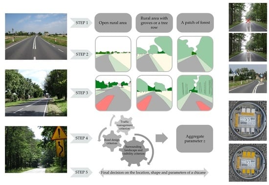
2.5. Fundamental Assumptions Taken in the Qualitative Analysis Concerning Determination of the Speed Reduction Determinants

All the obtained speed results were estimated in the ranges, as shown in Figure 4. On two sections, section No. 8 and section No. 9, which did not include chicanes, speeds were measured before and after the road sign communicating the boundary of the village and the built-up area. Considering that in the transition zone traffic calming schemes are applied primarily to reduce the speed at which the vehicles enter the village, Figure 4 gives also the value of 85th percentile speed measured after the chicane v85after. The analysis of the data presented in Figure 4 showed a considerable variation of the speed values despite comparable amounts of lateral shift on all the test sections. The noted speed variations were particularly scattered at chicane No. 6, which is approached through a long straight section (over 2 km long), surrounded by farm fields and rows of trees which largely hide the village skyline (Figure 1f). Straight approach sections of a similar length surrounded by farm fields lead also to the chicanes No. 1 (1.5 km) and No. 4 (2 km) (Figure 1a,d). Also chicanes No. 5 and No. 7 are approached through straight sections of a similar length (Figure 1e,g). In these cases, however, the Approach Sections go through a patch of forest.
The analysis of the scattering of speed variations on the above-mentioned sections showed that they are much smaller, except for the chicane No. 1, which indicates an existence of some other determinants that affect the drivers’ perception and, as consequence, also the village inbound speeds. The two analysed additional cases, i.e., approaches No. 8 and No. 9 (Figure 1h,i) also had opposite inbound speed values, and therefore, in this case we can also assume existence of additional determinants in the transition zone, which influence the drivers’ perception, and thus the vehicle speeds.
The data presented in Figure 4 show that the large variation of the 85th percentile speed reductions can be associated with various factors influencing the speed values before vbefore and after vafter the chicane. And these determinants can influence the vehicle speeds and the obtained reductions Δv to a varying degree. Also the results compiled in Figure 4 do not confirm the thesis put forward in [43] (Table 1—position 6) that central islands shifting one lane by up to 3 m, situated on the village inbound lane influence the speed and the amount of its reduction to a similar extent in all the situations. On all the analysed sections, except for the section No. 3, the horizontal deflection of the travel lane was a = 2 m, and yet both the village entry speeds and the amounts of speed reduction varied considerably. Also the results speed after the chicane vafter and speed reduction Δv (Figure 4) do not confirm the thesis put forward in study [28] (Table 1—position 7), that Δv = f(lv/tv), because in all sections tested, except No. 3, lv/tv = const, the results speed after the chicane vafter and speed reduction Δv are very diverse. Similarly, the results presented in Figure 4 do not confirm theses formulated in the publications [18,39,43,49,50,51] (Table 1—position 8, 9, 10), because the road class, lane width, chicanes shape, angles, curb heights were the same in all tested sections, except No. 3, and the obtained vafter and speed reduction Δv were very diverse (vafter = 64.7–87.4 km/h and Δv = 0.6–22.8 km/h). Based on these observations, the authors analysed different factors noted in the transition zones selected in three criteria concerning: Traffic management scheme, road design parameters, surrounding landscape and visibility conditions.

2.6. Genesis of the Aggregate Parameter z and ts Combined Effect on the Traffic Parameters

The analysis of the diversity and variation of the factors noted in the transition zones of the analysed test sections in relation to the traffic control, road design parameters, surrounding landscape and visibility conditions indicated a need for detailed analysis of the effect of the respective factors on the vehicle speeds and on their reduction. The authors in the publication [53] presented preliminary considerations of factors likely to contribute to the speed reduction. However, further consideration of possible determinants allowed for the developed an innovative analytical approach and introduced an independent variable z to consider the criteria adopted in the analyses (Figure 5). The proposed independent variable z is actually an aggregate parameter, introduced by the authors of this article, to quantify the overall impact of the surrounding landscape on the driver’s perception, leading to the reduction of the village inbound speed (Figure 6).
z i = Σ(zo i, zd i, zzw i) = Σzo i,j + Σzd i,j + Σzzw i,j.
The analyses assume that the qualitative indirect factors chosen in a given criterion will be assigned the assumed ‘quantitative measures’ in the binary system, which are directly related to the confirmation of existence of a given factor, i.e., confirmed logical tautology. For instance, if a given factor is confirmed in field, it is assigned the value 1 (i.e., logical tautology is confirmed). If, on the other hand, a given factor is not observed, then it is assigned the value 0 (i.e., logical tautology is not confirmed). In some cases, especially related to quantitative-qualitative information, such as clearance distance to buildings or visual obstruction, it was necessary to introduce an intermediate quantitative measure and then the assignment of the value 0.5 is proposed. If, for example, the village skyline is visible while passing through the chicane at a distance smaller than 100 m, then logical tautology is confirmed and when it is not visible the logical tautology is rejected. There was a need for an intermediate measure when the village skyline was visible from other distance, for example 300–500 m.
The intermediate factors related to the traffic management scheme criterion, preliminarily chosen for the analyses, included the distance to the nearest residential buildings located close to the road edge measured along the road from the D-42 traffic sign designating the built-up area limit, location of pedestrian pavements or other road infrastructure elements in relation to the D-42 traffic sign and the location of the B-33 speed limit sign in relation to the chicane axis (Figure 7).
In the criterion concerning the road design parameters also hourly traffic volume on both lanes and on the inbound lane alone were considered. The analysis demonstrated that the speeds measured before the chicane did not depend on the hourly traffic volume which, on the analysed roads, did not vary much (correlation factor of only R = 0.4). Whereas, the correlation factor between the speeds measured after the chicane and hourly volume of traffic was R = 0.6. The above facts indicate the existence of some other determinants influencing reduction of speed after the chicane, and therefore, the effect of the hourly traffic volume on the amount of speed reduction by the chicane was disregarded in the further analyses in the road design criterion. One of the main factors in the criterion relating to the road design parameters, in accordance with the conclusions given in [19,43] was the amount of the lateral deflection of the inbound lane. On the basis of site visits and Google Earth imagery [52] the qualitative factors were expanded with elementary road data related to curved sections, road infrastructure, accesses and junctions. Selected road design factors and the adopted engineering interpretation of their qualification measure are presented in Figure 8.
The last criterion concerning the surrounding landscape and visibility conditions, includes, as independent variables, various qualitative/quantitative factors defining the space around chicanes and elements determining the visibility conditions. In the selection and description of the visibility conditions the authors used the results of fixation points distribution analysis in different driving conditions, as presented in [14] (Figure 9). Referring the fixation points to the more distant view of the road on the test section with 70 km/h speed limit (Figure 9b) the authors found out that the driver tends to focus the eyesight firstly on the road further ahead and on the existing chicane and only secondly on the travel lane and on the upcoming lateral deflection of the lane.
Next, on the basis of the resulting visual attention area of the driver, described in [14], the authors referred it on a likewise basis to the analysed test sections, as displayed in Figure 10. Taking the above into consideration, the authors made a visualisation of the central and peripheral vision areas, as described, for example in [17,55], the results of which are presented in Figure 11. The analysis of the results of this visualisation enabled the authors to determine what are the elements on which car drivers travelling at a speed of 70 km/h or 100 km/h focus their attention, as presented in Figure 11c,d and Figure 12.
Based on the analysis of the central field of vision area and the road infrastructure elements present within its limits, of the view of the road further ahead and the elements of the landscape surrounding the road at the chicane the authors proposed appropriate factors and assigned quantitative measures to them, also with the application of logical tautology, as presented in Figure 12.
Summing up the above considerations, in relation to the above-described three criteria (Figure 5), the authors chose to perform statistical inference associated with the determination of the strength of a correlation between the above-described qualitative variables (zo, zd, zzw), the parameters representing the speed (v, ∆v, w) and also the general aggregate parameter z. To this end, they decided that the numerical value of the aggregate parameter z should be determined using the scheme presented in Figure 5 and Figure 6. In the statistical analyses regarding parameters characterising speeds the authors decided to analyse all the estimated speed distribution parameters, measured before and after the chicanes and the corresponding speed reductions.
Furthermore, they decided to analyse the speed reduction index in relation to the 85th percentile speed w (v85) (Equation (2)) and the mean free-flow speed w (vav) (Equation (3)), calculated with the following standard equations:
w (v85) = (v85 beforev85 after) / v85 before,
w (vav) = (vav beforevav after) / vav before.

3. Results

3.1. Outcomes of the Assessment of the Factors Associated with the Traffic Management Criterion

For the sake of clarity, the adopted quantification measures, in accordance with the logical tautology, i.e., confirmation or lack of confirmation of a given factor (Figure 7), initially expressed in the binary numeral system were represented by colours (Figure 13), with the dark blue colour designating the measure of location equal to 1, confirming the presence of a given factor or the corresponding small distance, etc. The light blue colour designates the quantification measure equal to 0, i.e., lack of the presence of a given factor, for example a large distance, etc. The intermediate shade designates, for example, location of E-17 and D-42 signs after the chicane at a distance exceeding 100 m. In the case of the additional test sections, No. 8 and No. 9, which did not include chicanes, no weights were assigned to the traffic management related factors conditioned by the presence of a chicane (and hence the lack of colour in the chart).
The analysis of the values of the quantitative measures represented in Figure 13 demonstrated consistency of a number of selected factors with the speed reduction values. To be specific, such consistency was obtained between speed reduction and the factor representing: location of the B-33 sign in relation to the chicane axis, confirmation of the presence of buildings after the sign location and confirmation of the presence of buildings in close proximity to the road edge. A consistency between the greatest reduction of the 85th percentile speed ∆v85 with the visibility of the nearby village skyline or road infrastructure after the D-42 sign (Figure 13) was confirmed in only one case.
For factors associated with the location of the E-17 and D-42 signs the authors noted lack of consistency with speed reduction. It is likely that the view of the nearby village buildings seen after the E-17 and D-42 signs affects the driver’s perception, resulting, in consequence, in the reduction of driving speed (Figure 1a). If after the E-17 and D-42 signs located at different distances after the chicane the village skyline or adjacent buildings are not visible, especially on the inbound lane side (Figure 1b,d,e), the traffic signs indicating the beginning of the built-up area do not have any mobilising effect on motorists’ behaviour who continue driving without slowing down.
Taking the above into account, in relation to the four factors concerning location of the E-17 and D-42 signs the logical tautology was represented by colours, however no numerical values were assigned to them, since the distances dE-17 of the E-17 sign location from the chicane ranged from 5 m before the chicane up to 120 m after the chicane, and the distance dD-42 of the D-42 sign ranged from 29 m to 290 m after the chicane. Such a high data dispersion prompted the authors to determine the coefficient of correlation between the above-mentioned distances and the speed reductions on the sections under analysis. The values of the correlation coefficient were respectively R = 0.4 (f(dE-17, ∆v85)) and R = 0.2 (f(dD-42, ∆v85)), which indicated a lack of statistically significant relationship between the amount of speed reduction and the distance of the sign location from the chicane.
Taking the above into consideration we can conclude that the distance at which the E-17 and D-42 signs are located from the chicane, if it is not related to the visibility of buildings, has no significant effect on the actual vehicle speeds measured after the chicane. However, if the chicane is preceded by the B-33 sign denoting a speed limit of 70 km/h then consideration of logical tautology related to the close vicinity of the village buildings (located along the street) would not be in compliance with the Polish highway code [56] and the guidelines [57] and, moreover, it would pose problems with defining logical tautology related to assignment of a value to a given distance. Therefore, in the outcomes of the assessment of the factors related with the traffic management criterion no quantitative measures are assigned to the above-mentioned four factors (Figure 12).
Summing up the above considerations we can conclude that in the case of chicanes located in the transition zones with the posted speed limit of 70 km/h the determinants effectively reducing the speed include: placement of the B-33 sign before the chicane at a distance of up to 100 m and visible close village buildings situated after the D-42 sign at a distance less than 100 m.

3.2. Outcomes of the Assessment of the Factors Associated with the Road Design Parameters Criterion

The second criterion considered in identification of the determinants of the effectiveness of chicanes in the transition zones is associated with the factors defining the road design parameters. In this criterion, various dependency relationships between road design parameters and reduction of the 85th percentile speed ∆v85 were confirmed. A representative relationship of the analysed variables was confirmed in relation to the amount of lateral deflection of the lane. However, the selected test sections included primarily central islands of rectangular shape horizontally deflecting one lane with the deflection of a = 2 m (Figure 14a). A central island horizontally deflecting both lanes with the deflection of a = 1 m (Figure 14b) was located on only one test section.
Another factor with a varying effect on traffic speed reduction was also a visible access. When an access led to a cluster of buildings then a greater speed reduction was noted. Still the scale of the reduction varied considerably, ranging from 3.5 km/h to 22.8 km/h (Figure 15). In the case of a private accesses serving a single family building the speed reductions also varied but over a smaller range (Figure 15–∆v85 = 1.9–3 km/h). A similar varied effect was noted for an intersection with a side road, in which case the speed reduction was in the range of ∆v85 = 1.9–9.5 km/h.
The analysis of the variation of the sum of quantitative measures representing the road design parameters zd and of the speed reduction amount ∆v85 revealed a probable consistency between the considered variables (Figure 15). The only exception in the analysed case is the test section No. 7 where a smaller number of significant road factors was noted, as compared to the other sections.

3.3. Outcomes of the Assessment of the Factors Associated with the Landscape and Visibility Criterion

The last criterion considered in the identification of the determinants of the effectiveness of chicanes in the transition zones are the factors related to the landscape features in the immediate vicinity of the entry section of the road and to visibility conditions. In this criterion very important dependencies were confirmed between the speed reduction ∆v85 and the sum of quantitative measures zzw in particular in relation to the first three test sections (Figure 16). Figure 1a,b show the village skyline seen from a distance of 300 m by a driver approaching the chicane located on each of the first two test sections, i.e., section No. 1 and section No. 2.
Figure 17a,b depict the village skyline as seen by a driver passing through the chicane. In the case of section No. 1, the driver sees nearby buildings after the sign D-42 and a horizontal curve limiting the view of the road further ahead (Figure 17a) and this is probably the main cause of the considerable reduction of the free flow speed noted at this section, equal to ∆v85 = 22.8 km/h. In the second case presented in Figure 17b the driver on the approach to the chicane sees the distant village skyline and remote buildings situated at a distance of ca. 300 m at the other side of the road. In this case the E-17 & D-42 signs are located after the chicane, which results in a much smaller reduction of the free-flow traffic speed (∆v85 = 9.5 km/h). Figure 17c,d, show the approach to the chicane on section No. 3 and the view of the road ahead the driver sees when going through the chicane. In this case, the free-flow speed reduction is ∆v85 = 7 km/h. This can be attributed to the lack of visibility of the village skyline and of nearby buildings and to the fact that the lateral deflection a of the lane is only 1 m. Furthermore, the traffic management infrastructure, namely the sign No. D-42 denoting the beginning of the built-up area is placed as far as 300 m after the chicane.
On the remaining test sections (No. 4, No. 5, No. 6 and No. 7) the authors noted high variability between the assigned quantitative measures and speed reduction values. The partial sums of the four primary factors, represented in Figure 16 have similar values, yet their distribution in the analysed sections is very diverse, just as diverse are the speed reduction values. A very wide variation in the respective quantitative measures is also observed in the case of the two last factors represented in Figure 16, where visual obstructions or buildings situated close to the chicane were confirmed only in one case, while in the remaining three cases visible buildings were noted however they were situated at a further distance from the chicane. Still, comparing the sums of quantitative measures zzw with the speed reduction values ∆v85 on the respective test sections, we can detect a certain consistency in the succession of changes, as represented in the radar charts.

3.4. Outcomes of the Assessment of the Aggregate Parameter z and Its Overall Effect on the Traffic Parameters

Summing up the above analyses, Figure 18 below represents the probable consistency between the qualitative variable z, i.e., the aggregate overall effect of the factors related to traffic management (zo), road design parameters (zd) and landscape and visibility conditions (zzw), and the calculated free-flow speed reductions ∆v85 and ∆vav on the analysed test sections with the applied horizontal deflection of the lane(s). Figure 18b represents the consistency of the aggregate parameter z with the values of speed reduction indices.
The analysis of variations of the analysed values exhibits the greatest consistency between the free-flow speed vav and the speed reduction index w (vav) and the proposed aggregate parameter z representing a combination of factors, including traffic management, road design parameters and the surrounding landscape elements and visibility conditions.

3.5. Regression Analysis of the Outcomes of Assessment of the Combined Effect of the Selected Factors and Speed Distribution Parameters

In the next step, the authors carried out appropriate regression analyses in relation to the investigated parameters. In the regression analyses, whether confirming or failing to confirm the effectiveness of the applied chicanes, the authors considered both the aggregate values of the respective components of qualitative variables (zzw, zd and zo) and the qualitative variable z representing the combined effect of the respective factors in the transition zone. In relation to the speed distribution parameters before and after the chicane the analysis considered both the free-flow 85th percentile speed v85, the average free-flow speed vav and the stable-flow speed vav pp, and also the corresponding speed reduction values ∆v. Along with the speed distribution parameters the authors considered also the speed reduction index w, often taken into account in traffic calming analyses and representing the percentage speed reduction in relation to the initial value (w = ∆v/vbefore). The correlation coefficient values are given in Table 2 and Table 3. In Table 2 and Table 3 bold numerals denote cases when the correlation coefficient R was greater than 0.9, which according to the statistical principles given in [58,59] indicates a statistically significant relationship between the analysed variables.
Appropriate regression analyses were carried out considering the obtained positive results of the correlation coefficients in relation to the searched-for relationship between the speed reduction ∆v or the speed reduction index w and the magnitude of the effect of the qualitative variable z. The results of the regression analysis in relation to the dependent variables v85 and w (v85) are represented in Figure 19.
The relationships represented in Figure 19 prove the hypotheses previously put forward by the authors that the reduction of speed through the chicane depends on a number of factors characterizing the spatial features of the surrounding area, which jointly influence the drivers’ behaviour and their decision to slow down in the transition zone section. Referring to both foreign guidelines (Denmark [1], Great Britain [2,19,31,39,41], USA [27,36,37]) and Polish publications [5,21,42] which, depending on the country, give various data regarding the percentage reduction of speed of vehicles passing through chicanes, it can be concluded that the theses proposed in these materials have been confirmed by the results obtained by the authors in this research. Still, it must be noted that the amount of speed reduction depends on several external factors which were for the first time identified and estimated in this article.
Figure 20 represents the same regression analyses carried out in relation to the free-flow average speed vav. The analysis of the data shown in Figure 20 indicates that the average free-flow speed vav statistically significantly depends on the combined magnitude of the effect of the landscape elements present within the transition zone, which is confirmed by the high values of the correlation coefficients (Table 2 and Table 3). The more of various landscape elements are present within the transition zone to the village in the vicinity of the on-road chicane, the greater speed reduction ∆v can be expected. The above observations can indicate to land planners and designers the most suitable locations in which to design and install chicanes effectively reducing traffic speeds, subject to considering the maximum number of relevant factors.
If there are buildings or elements of highway structures (i.e., visual obstructions) within the transition zone and they are situated close to the road edge, then the chicane should be designed at a location as close as possible to these elements. Furthermore, in order to obtain effective speed reduction, horizontal deflection of the lane by min. 2 m should be considered, located at a distance of up to 100 m from the visible nearby buildings of the village. If the transition zone is approached through a long straight section running through an open area, then for effective speed reduction, the amount of the horizontal deflection of the lane, should be designed taking into account the view of the village skyline and the distance of the chicane from the village buildings in view, measured along the road. The best results in terms of traffic speed reduction can be achieved at locations where the village buildings are situated close to the inbound lane.

4. Discussion

This article analyses seven sections of roads leading through villages with chicanes installed in the transition zones. The analysis of the performed speed survey data represented in Figure 4 demonstrated a very wide and varied dispersion of speeds despite the fact that in almost all of the cases the analysed chicanes provided the same amount of the horizontal deflection of the carriageway lane. The comparison of the results obtained with speed survey data for two other sections, No. 8 and No. 9, without any chicanes installed, demonstrates that speed reductions were noted also on these sections. In view of the above, it is clear there must have been some other determinants resulting in speed reduction in these locations.
In the course of the analysis the authors formulated ten-odd such determinants which could have an effect on the obtained speed reduction. Based on comprehensive analysis of factor assessment values obtained in the individual criteria proposed and of the final values of the aggregate parameters z on the test sections, in recapitulation we can identify the main determinants. For instance, in the traffic management criterion these will be the factors directly related to the view seen by the driver after the D-42 sign (Figure 13) and in the road design criterion, the factors related to horizontal curvature and its parameters (Figure 15). The greatest number of factors which obtained confirmation of logical tautology in the landscape and visibility criterion were related to the surrounding conditions in the vicinity of the road on the approach to the village and in the transition zone (Figure 17). On the test sections with the greatest speed reductions confirmed also other factors with positive logical tautology were confirmed, relating to the visibility conditions and the elements that can be visible to the driver when approaching and passing through the chicane, namely the village skyline, a view of single buildings situated close to the road or a clear view of some road infrastructure elements associated with the built-up area. Summing up the above considerations, in the opinion of the authors the obtained results confirm the postulated hypotheses and proposals regarding the introduction of the aggregate parameter z, which evidently has an effect on the magnitude of speed reduction of vehicles which enter the village (Table 2 and Table 3 and Figure 19 and Figure 20).
Limiting the analysis to only the test sections located in open rural areas, we can confirm that visibility conditions have a major effect on drivers’ decision to reduce speed. These include the view of the village skyline on the approach to the transition zone, of nearby buildings and road infrastructure elements such as pedestrian pavements, accesses, junctions, visual obstructions e.g., bridge railings, and also the presence of horizontal curvature and the resulting limited view of the road ahead and its direct vicinity. Therefore, in choosing the location for a chicane to be provided as part of a traffic calming scheme, designers and landscape planners should, in the first place, consider the logical tautologies of the above given factors. The precise location of the chicane should also take into account the logical tautologies relating to the view of the village skyline, nearby buildings or visible elements of the road infrastructure in relation to the existing D-42 sign denoting the beginning of built-up area (Figure 21). If a confirmation of logical tautologies was obtained for all the above-mentioned elements, then the chicane should be located as close as practicable to the D-42 sign. With these conditions met, one can expect that the desired speed reduction ∆v85 = ca. 1020 km/h will be achieved within the transition zone with the 70 km/h speed limit signalled on the B-33 sign (Figure 4, Sections No. 1, No. 2 and No. 3).
The analytical approach proposed by the authors for application by land planners and designers of traffic calming schemes in transition zones to villages is presented in Figure 21. In the first step (Figure 21–Step 1, background) consideration should be given to the type of terrain and landscape elements present in the area surrounding the road in the transition zone to the village. In this study the authors proposed the three following types of road surroundings: open rural area, rural area with groves or a tree row and a forest terrain. The above-mentioned landscape conditions in the surroundings of the road have a determining effect on the vehicle’s speed of approach to the transition zone, driver’s perception and, as a consequence, on the amount of speed reduction on the way through the chicane. Next, based of the logical tautologies confirmed during the site visits or when reviewing the available Google Earth or Street View imagery [52], the land planners should determine the value of the aggregate parameter z (Figure 21—Step 2—the analytical process regarding the conditions on the approach to the village’s transition zone). Further, a similar analysis should be carried out for the landscape elements present in the surroundings of the road in the vicinity of the planned chicane location (Figure 21—Step 3—preliminary location of chicane). This should involve an analysis of the road alignment along a straight section or horizontal curvature, assessment of the visibility of the road ahead and of existing locations of the vertical signs E-17 and D-42, etc. Having initially assessed the landscape conditions in the surroundings of the approach to the transition zone and the planned chicane location, the next step should involve estimation of the individual factors in the three above-mentioned criteria and the value of the aggregate parameter z (Figure 21–Step 4–the assessment of the aggregate parameter z). After determining the aggregate parameter z we can move to the final step in designing a traffic calming scheme in a village transition zone with 70 km/h speed limit, namely to final determination of the chicane location and adoption of its parameters (Figure 21—Step 5—chicane design).
If in an open rural area there is no village skyline or nearby buildings in view, then a small speed reduction can also be expected even without a chicane on sections with horizontal curvature hiding the view of the road ahead, as confirmed by the measured vehicle speeds on the section No. 9 (Figure 4 and Figure 1i).
With a greater number of confirmed logical tautologies (i.e., when the value of the aggregate parameter z is higher than 10), according to the authors, chicanes resulting in horizontal deflection of one lane only can be considered for installation in the transition zones if the deflection of the lane from the straight line is at least 2 m. With a smaller value of aggregate parameter z, in order to achieve satisfactory speed reduction, the chicane location should be planned closer to the existing buildings and road infrastructure elements and the applied lane deflection should be considerably larger (Figure 22). In cases when satisfactory speed reduction has not been achieved with chicanes already in place in transition zones, an additional traffic calming measure should be planned for installation in the vicinity of nearby village buildings.
If installation of a chicane deflecting one lane only is planned in the transition zone to the village situated on road section going through a patch of forest where the driver can see neither the village skyline nor nearby buildings, the authors propose to locate the chicane as close as possible to the D-42 sign and use semi-circular chicanes providing deflection of the lane considerably greater than 2 m, i.e., according to the recommendations given in the guidelines [21,24,25] (Figure 22). Guidelines [25] give also detailed recommendations regarding the size of the radius. For example, for the speed of 70 km/h the entry radius R1 should not be smaller than 100 m and the subsequent radii (R2, R3) should be either equal or greater than the entry radius R1. The corners of the chicane should be rounded and the accompanying hatched road markings area should end with a pointy tip. The other dimensions of the chicane should be accommodated within the road design parameters, i.e., available right-of-way width (conditioning the size of desired horizontal lane deflection) and national regulations concerning road surface markings.
An example of semi-circular chicane deflecting one lane, installed in a village transition zone in a partly forested area is shown in Figure 23. The effectiveness of semi-circular chicanes installed in transition zones to villages and the resultant further applications of supplementary traffic calming measures provided on the passage of the regional road through the village area was described by the authors in [60].
However, in the opinion of the authors, the process of designing chicanes in village transition zones should not be limited to the selection of the chicane location and its geometrical parameters but it should include proposing application of the latest technologies which are gaining increasingly wide use in the field of traffic engineering. This concerns traffic controls, including both upright signs and pavement markings, where solar technology is being introduced, resulting in considerable energy conservation in built-up areas and in significant improvement in traffic safety. The problem of the effect of LED lighting and its relationship with the speed and improved view of the road ahead has been tackled in a number of publications. For instance in [61] the authors described the results of studies on the use of an active system for delineating the road ahead in order to enhance the ability of drivers to control their vehicle safely on winding roads. A simulator experiment compared night-time driving on a country road under the three following conditions: on an unlit road, on a road illuminated on curves by typical road lighting luminaires, and on a road with an active lane delineation application, where self-luminous road studs are turned on to outline the lane and road edges as the driver approaches and passes the curves. It was concluded that the tested LED application enhanced the ability of drivers to control the virtual car, as compared to an unlit road or road lighting. Considering that transition zones to villages on roads carrying through traffic usually are not provided with road lighting the authors have analysed the results of the research described in the publication [62]. Light conditions are essential factors in traffic safety, but the relationship between light conditions and vehicle speed is not fully understood and has rarely been examined. In the course of the study, the authors of [62] investigated three questions: (a) if vehicle speed between brighter and darker conditions in clear weather will be different; (b) if vehicle speeds are lower during rain and snow than in clear weather conditions and if so; (c) if the speed reduction in rainy and snowy weather conditions is more substantial on roads without road lighting in darkness. The results of the study [62] demonstrated no evidence of consistent patterns of speed differences with respect to lighting conditions (darkness, daylight, twilight or road lighting) under clear weather conditions and no effect of road lighting on speed reduction in rainy and snowy weather. Another study described in publication [63] examined the effect of the light emitting diode (LED) road lighting of a residential road section with speed humps on speed reduction. The study results indicated that the LED road lighting that was placed directly above or in front of the hump achieved the highest luminance. Still, the study did not reveal any significant differences in vehicle speed attributable to light conditions per se.
In the recent years solar components are increasingly being used in solar powered traffic signs (Figure 24). The conditions prevailing on the test sections described in this article indicated that it might turn out to be important to use upright signs equipped with light emitting diodes (LED), which according to the results of the research described in [64] score a better detection ratio than conventional upright signs. Solar LED lights are high capacity light sources powered with batteries self-charging during the day. Depending on the weather conditions during the day, solar energy is converted to electricity by means of photovoltaic cells and stored in ultracapacitors capable of supplying impulse power according to an established program, both overnight and during the day. These devices are wireless, switched on automatically, low maintenance and eliminate the need to extend the lighting system serving the village centre, i.e., they allow to considerably lower the consumption of energy. All the materials used to manufacture the presented solar devices are recyclable, so they do not create any environmental burden and hence require no extra energy input. The operating temperature range of these devices ranges from –40 °C to +70 °C. Their usual warranty period is around 10–12 years, depending on the manufacturer. Also according to the conclusions formulated in guidelines [4] the D-6a sign (Figure 24b) on the approach nose of the central island horizontally deflecting one lane is a better option than using the U-5 bollard in this location (Figure 24a) since the D-6a sign forms a kind of a visual obstruction having an effect on drivers’ perception and increasing the reduction in vehicle speeds by additional 1–3 km/h. Still the amount of speed reduction depends mainly on the width of the deflected travel lane and the size of horizontal deflection applied.
Additional solar elements installed in the face of the entrance island, on the outer edge of the carriageway and on the guide posts (Figure 25) are another element related to energy conservation in village environments evidently contributing to the reduction of vehicle speeds in village transition zones. They are recommended by the authors for use in particular in transition zones situated in forest terrain. These are SolarCAP elements, i.e., self-contained LED lighting devices. They are not equipped with additional batteries, which makes them less expensive, and apart from contributing to conservation of energy they also reduce construction and maintenance costs and improve traffic safety owing to their better visibility, and hence a greater impact on drivers’ perception. They are produced from environmentally friendly materials and are suitable for recycling. Furthermore, SolarCAP devices are maintenance free for at least 10 years from installation. They are resistant to mechanical damage and frost and water resistant.
Their principle of operation is similar to that described above, i.e., during the day solar energy is converted to electricity by means of photovoltaic cells which is subsequently stored in EnergyCache ultracapacitors capable of providing impulse power according to an established program, both at night and at day time. At dusk, a Solar CAP device switches on automatically and emits directional light produced in LEDs. The charging time to full charge is ca. 1 h in harsh sun or 6–8 h under cloudy weather. A fully charged SolarCAP can operate continuously for over 12 h.
Based on the conclusions from the tests carried out on the TRL track [24], in locations with poorer visibility conditions, for instance in forest terrains or in rural areas with local groves, the authors can recommend placement of guide posts behind the outer edge of the road, spaced by maximum 0.5 m from the edge of the road (Figure 25c,d). Such arrangements are particularly recommended in the case of varied topography around the chicane (i.e., presence of embankments or drainage ditches). That said, in line with the recommendations of [3], in rural areas, where oversize farm equipment (such as combine-harvesters) traffic was recorded in traffic surveys, the road shoulder should be additionally strengthened over up to 1 m width over the whole length of the lateral deflection of the lane. Such strengthening can be made of (irregular) cobblestones. This measure will prevent deterioration of the dirt shoulder, as shown in Figure 26a. Surfacing the shoulder with asphalt millings is not recommended, as car drivers may mistakenly take such surface for paved shoulder and try and use it for normal travel (Figure 26b).
Summing up the discussion conducted in reference to the obtained research results, the authors postulate that there is a need for further analyses and for confirmation of the proposed hypothesis on the identification of determinants of the effectiveness of chicanes on other roads, for example on roads subject to a 50 km/h speed limit, or for use differently designed road chicanes in the transition zones to villages.

5. Conclusions

Recapitulating the analyses carried out under this research, it can be concluded that the authors have obtained a confirmation of the existence of the identified determinants and of their effect on speed reduction in the transition zones to villages on roads with a 70 km/h speed limit indicated by the B-33 traffic signs. The important determinants identified in this research, which have a considerable effect on speed reduction are associated primarily with the view available to the driver on the approach to the village and directly in the transition zone, including: the village skyline, nearby clustered buildings or clearly visible elements of road infrastructure related to the built-up area. The size of provided horizontal deflection of the travel lane is another important factor, particularly significant with regard to rectangular chicanes horizontally deflecting one travel lane, installed on inbound lanes to villages.

Author Contributions

Conceptualization A.S., D.K. Methodology A.S. Formal analysis A.S., D.K. Data curation D.K. Writing—original draft preparation A.S. Writing—review and editing A.S. Visualization A.S., D.K. Supervision A.S. Funding acquisition D.K. All authors have read and agreed to the published version of the manuscript.

Funding

The researches included in the paper were partly financed by grants of WBiA ZUT: DKD Decision No. 517-02-033-6728/17.

Conflicts of Interest

The authors declare no conflict of interest.

Appendix A

Table A1. Results of standard statistical tests on test sections.
Test SectionsGoodness-of-Fit Test
H0: F(v) = F0(v)
H1: F(v) ≠ F0(v)
Significance Test u
H0: vbefore = vafter
H1: vbeforevafter
Significance Test t
H0: vbefore = vafter
H1: vbefore > vafter
Test for Equality of Variances F
H0: sbefore2= safter2
H1: sbefore2>safter2
λ(v before)λ(v after)λα, α= 0.05uuα, α= 0.05ttα, α= 0.05FFα, α= 0.05
No. 10.370.581.365.851.965.851.63.031.61
No. 20.450.481.366.331.966.331.61.751.54
No. 30.630.701.363.621.963.621.61.721.63
No. 40.490.241.361.631.961.631.61.021.62
No. 51.240.681.360.731.960.731.61.311.61
No. 60.720.151.361.921.961.921.62.381.64
No. 70.630.711.363.761.963.761.61.681.54
No. 81.170.781.361.221.961.221.62.291.55
No. 90.730.581.360.881.960.881.61.391.55

Appendix B

Table A2. Results of goodness-of-fit test on test sections (free speed v and vehicle flow speed v pp).
Test Sectionsv before and v afterv pp before and v pp after
λλα, α= 0.05λλα, α= 0.05
No. 13.041.364.251.36
No. 22.551.362.611.36
No. 32.201.362.231.36
No. 40.981.360.961.36
No. 50.501.361.251.36
No. 60.891.360.371.36
No. 72.121.362.461.36
No. 80.421.360.371.36
No. 90.611.360.551.36
Designations colour in the table results of goodness-of-fit test (free speed): H0: F(vbefore) = F(vafter) λ < λα H1: F(vbefore) ≠ F(vafter) →λλα. Designations colour in the table results of goodness-of-fit test (vehicle flow speed): H0: F(v pp before) = F(v pp after) λ < λα ;H1: F(v pp before) ≠ F(v pp after) → λλα.
Table A3. Results of goodness-of-fit test on subsequent test sections (free speed vafter and vehicle flow speed v pp after).
Test Section i and i+1vafteri and vafter i+1v pp after i and v pp after i+1
λλα, α = 0.05λλα, α = 0.05
No.1 and No. 21.041.362.761.36
No. 2 and No. 30.991.361.191.36
No. 3 and No. 41.461.361.661.36
No. 4 and No. 51.321.361.021.36
No. 5 and No. 61.491.360.901.36
No. 6 and No. 71.051.361.191.36
No. 7 and No. 84.481.364.861.36
No. 8 and No. 93.721.363.611.36
Designations colour in the table results of goodness-of-fit test (free speed): H0: F(vafteri) = F(vafteri+1)λ < λα; H1: F(vafteri) ≠ F(vafteri+1) →λλα. Designations colour in the table results of goodness-of-fit test (vehicle flow speed): H0: F(v pp afteri) = F(v pp afteri+1) λ < λα; H1: F(v pp afteri) ≠ F(v pp afteri+1) →λλα.

Appendix C

Table A4. Results of test of independence on test sections (free speed v and vehicle flow speed v pp).
Test Sectionv before and v afterv pp before and v pp after
χ2χα2, α= 0.05χ2χα2, α= 0.05
No. 125.73.8428.53.84
No. 215.63.8416.83.84
No. 39.73.8414.33.84
No. 44.33.844.23.84
No. 51.003.847.63.84
No. 60.983.840.83.84
No. 73.803.846.13.84
No. 80.043.841.13.84
No. 90.033.840.083.84
Designations colour in the table results of test of independence (free speed): H0: P{X = vbeforei, Y = vafteri} = P{X = vbeforei}, P{Y = vafteri}χ2 < χα2; H1: P{X = vbeforei, Y = vafteri} ≠ P{X = vbeforei}, P{Y = vafteri} → χ2χα2. Designations colour in the table results of test of independence (vehicle flow speed): H0: P{X = v pp beforei, Y = v pp afteri} = P{X = v pp beforei}, P{Y = v pp afteri}χ2 < χα2; H1: P{X = v pp beforei, Y = v pp afteri} ≠ P{X = v pp beforei}, P{Y = v pp afteri} → χ2χα2.
Table A5. Results of test of independence on subsequent test sections (free speed v after and vehicle flow speed v pp after).
Test Section i and i+1vafteri and v after i+1v pp after i and v pp after i+1
χ2χα2, α= 0.05χ2χα2, α= 0.05
No.1 and No. 24.643.8417.83.84
No. 2 and No. 37.233.8412.33.84
No. 3 and No. 47.873.8412.93.84
No. 4 and No. 52.663.840.343.84
No. 5 and No. 63.393.841.193.84
No. 6 and No. 70.113.840.003.84
No. 7 and No. 876.443.8484.03.84
No. 8 and No. 952.463.8437.43.84
Designations colour in the table results of test of independence (free speed): H0: P{X = vafteri, Y = vafteri+1} = P{X = vafteri}, P{Y = vafteryi+1}χ2 < χα2; H1: P{X = vafteri, Y = vafteri+1} ≠ P{X = vafteri}, P{Y = vafteri+1} → χ2χα2. Designations colour in the table results of test of independence (vehicle flow speed): H0: P{X = v pp afteri, Y = v pp afteri+1} = P{X = v pp afteri}, P{Y = v pp afteryi+1}χ2 < χα2;H1: P{X = v pp afteri, Y = v pp afteri+1} ≠ P{X = v pp afteri}, P{Y = v pp afteri+1} → χ2χα2.

Appendix D

Table A6. Results of median tests on test sections (free speed v and vehicle flow speed v pp).
Test Sectionv before and v afterv pp before and v pp after
χ2χα2 , α = 0.05χ2χα2 , α = 0.05
No. 121.63.84178.23.84
No. 215.93.8417.73.84
No. 312.83.8416.33.84
No. 43.533.841.43.84
No. 57.953.845.13.84
No. 64.823.842.03.84
No. 716.063.8424.03.84
No. 80.203.841.23.84
No. 90.363.840.33.84
Designations colour in the table results of median tests: H0: F1(x) = F2(x)χ2 < χα2; H1: F1(x) ≠ F2(x) → χ2χα2.
Table A7. Results of median tests on subsequent test sections (free speed vafter and vehicle flow speed v pp after).
Test Section i and i+1v after i and v after i+1v pp after i and v pp after i+1
χ2χα2, α= 0.05χ2χα2 , α = 0.05
No.1 and No. 24.953.8431.83.84
No. 2 and No. 36.313.843.53.84
No. 3 and No. 415.983.849.53.84
No. 4 and No. 516.583.840.973.84
No. 5 and No. 65.633.844.03.84
No. 6 and No. 74.903.8413.43.84
No. 7 and No. 867.333.8490.63.84
No. 8 and No. 941.103.8437.43.84
Designations colour in the table results of median tests: H0: F1(x) = F2(x) χ2 < χα2; H1: F1(x) ≠ F2(x) → χ2χα2.

References

  1. Urban Traffic Areas—Part 7—Speed Reducers; Vejdirektoratet-vejregeludvalget: Copenhagen, Denmark, 1991.
  2. Traffic Calming Guidelines; Devon County Council Engineering & Planning Department: Devon, UK, 1992.
  3. Directives for the Design of Urban Roads. RASt 06; Road and Transportation Research Association, Working Group Highway Design, FGSV: Kӧln, Germany, 2006.
  4. Harvey, T. A Review of Current Traffic Calming Techniques; Universitat of Leeds: Leeds, UK, 2013. [Google Scholar]
  5. Krystek, R. Principles of Traffic Calming on the Roads of the Pomorskie Region in Poland, Part 1: Street Layouts in Towns and Cities; GAMBIT Pomorski: Gdańsk, Poland, 2008. [Google Scholar]
  6. World Health Organization (WHO). Global Status Report on Road Safety 2010–2018; World Health Organization: Geneva, Switzerland, 2018. [Google Scholar]
  7. Proctor, S. Accident reduction through area-wide traffic schemes. Traffic Eng. Control. 1991, 32, 566–573. [Google Scholar]
  8. Paige, M. Speed and Road Traffic Noise; UK Noise Association: Chatham, UK, 2009; Available online: http://www.ukna.org.uk/uploads/4/1/4/5/41458009/speed_and_road_traffic_noise.pdf (accessed on 1 July 2019).
  9. Ellebjerg, L. Noise Reduction in Urban Areas from Traffic and Driver Management—A Toolkit for City Authorities; Silence: Brussels, Belgium, 2008. [Google Scholar]
  10. Ellebjerg, L. Noise Control through Traffic Flow Measures—Effect and Benefits; Raport 151; Danish Road Institute: Hedehusene, Denmark, 2007. [Google Scholar]
  11. King, R. Noise and Speed—A Guest Blog from UK Noise Association. 2019. Available online: http://www.20splenty.org/noise_and_speed (accessed on 18 May 2020).
  12. Ghafghazi, G.; Hatzopoulou, M. Simulating the air quality impacts of traffic calming schemes in a dense urban neighbourhood. Transp. Res. Part D Transp. Environ. 2015, 35, 11–22. [Google Scholar] [CrossRef]
  13. Lantieri, C.; Lamperti, R.; Simone, A.; Costa, M.; Vignali, V.; Sangiorgi, C.; Dondi, G. Gateway design assessment in the transition from high to low speed areas. Transp. Res. Part F Traffic Psychol. Behav. 2015, 34, 41–53. [Google Scholar] [CrossRef]
  14. Babkov, V.F. Road Design Parameters and the Safety of Traffic; WKŁ: Warszawa, Poland, 1975. [Google Scholar]
  15. Hobbs, F.D.; Richardson, B.D. Traffic Engineering; WKŁ: Warszawa, Poland, 1971. [Google Scholar]
  16. Lunenfeld, H. Evaluation of Traffic Operations, Safety, and Positive Guidance Project; Federal Highway Administration, Office of Traffic Operations: Michigan, MI, USA, 1980.
  17. Crevier, C. Les Aménagements En Modération De La Circulation, Étude Et Applications; École De Technologie Supérieure Université Du Québec: Montréal, QC, Canada, 2007. [Google Scholar]
  18. Dixon, K.; Zhu, H.; Ogle, J.; Brooks, J.; Hein, C.; Aklluir, P.; Crisler, M. Determining Effective Roadway Design Treatments for Transitioning from Rural Areas to Urban Areas on State Highways; Final Report SPR 631; Federal Highway Administration: Washington, DC, USA, 2008.
  19. Roads Development Guide; South Ayrshire Council: Strathclyde Roads, Ayrshire, UK, 1995.
  20. Mackie, A.M.; Ward, H.A.; Walker, R.T. Urban Safety Project, Part 3: Overall Evaluation of Area Wide Schemes; TRRL Report 263; Transport and Road Research Laboratory: Crowthorne, UK, 1990. [Google Scholar]
  21. Krystek, R. Principles of Traffic Calming on the Roads of the Pomorskie Region in Poland, Part 2: Sections of Major Roads Through Towns and Villages; GAMBIT Pomorski: Gdańsk, Poland, 2008. [Google Scholar]
  22. Abdi, A.; Rad, H.B.; Azimi, E. Simulation and Analysis of Traffic Flow for Traffic Calming. In Proceedings of the Institution of Civil Engineers—Municipal Engineer; Thomas Telford Ltd.: London, UK, 2017; Volume 170, pp. 16–28. [Google Scholar] [CrossRef]
  23. Sayer, I.A.; Parry, D.I. Speed Control Using Chicanes—A trial at TRL; TRL Project Report PR 102; Transport Research Laboratory: Crowthorne, UK, 1994. [Google Scholar]
  24. Sayer, I.A.; Parry, D.I.; Barker, J.K. Traffic Calming—An Assessment of Selected On-Road Chicane Schemes; TRL Report 313; Transport Research Laboratory: Crowthorne, UK, 1998. [Google Scholar]
  25. Safe Road Design Manual; Amendments to the WB Manual, Transport Rehabilitation Project ID PO75207; Consulting Services for Safe Road Design: Loan, Sweden, 2011.
  26. Hernández, E.; Abadía, X.; París, A.C. Criterios de Movilidad ZONAS 30; Fundación RACC: Barcelona, Spain, 2007. [Google Scholar]
  27. Guidelines for Traffic Calming; City of Sparks, Public Works, Traffic Division: Reno, NV, USA, 2007.
  28. Berger, W.J.; Linauer, M. Speed Reduction at City Limits by Using Raised Traffic Islands; Institut fuer Verkehrswesen (Institute for Transport Studies), Universitaet fuer Bodenkultur A-1190: Vienna, Austria, 1998. [Google Scholar]
  29. Prato, C.G.; Rasmussen, T.K.; Kaplan, S. Risk Factors Associated with Crash Severity on Low-Volume Rural Roads in Denmark. J. Transp. Saf. Secur. 2014, 6, 1–20. [Google Scholar] [CrossRef]
  30. Vahl, H.G.; Giskes, J. Traffic Calming through Integrated Urban Planning; Amarcande: Paris, France, 1990. [Google Scholar]
  31. Local Transport Note 01/07; Traffic Calming, Department for Transport, Department for Regional Development (Northern Ireland), Scottish Executive, Welsh Assembly Government: Scottish, UK, 2007.
  32. Seneci, F.; Avesani, F.; Bonomi, I. Piani particolareggiati per mobilita’ ciclabile e pedonale e sicurezza stradale; Comune di Bassano del Grappa: Verona, Italy, 2012. [Google Scholar]
  33. Sadeghi-Bazargani, H.; Saadati, M. Speed Management Strategies; A Systematic Review. Beat 2016, 4, 126–133. [Google Scholar] [PubMed]
  34. González, D.D. Evaluación de las Zonas 30 en Europa y definición de una Zona 30 revisada. Ph.D. Dissertation, Infraestructura del Transporte y del Territorio (ITT), Universitat Politècnica de Catalunya, Barcelona, Spain, 2012. [Google Scholar]
  35. Le Temps des Rues; IREC, Federal Technical University of Lausanne: Lausanne, Switzerland, 1990.
  36. Bahar, G.B. Guidelines for the Design and Application of Speed Humps; Institute of Transportation Engineers: Washington, DC, USA, 2007. [Google Scholar]
  37. Hallmark, S.L.; Peterson, E.; Fitzsimmons, E.; Hawkins, N.; Resler, J.; Welch, T. Evaluation of Gateway and Low-Cost Traffic-Calming Treatments for Major Routes in Small Rural Communities; Institute for Transportation, Iowa State University: Iowa, IA, USA, 2007. [Google Scholar]
  38. City of Seattle Staff Directory, Streetscape Design Guidelines, Chapter 6; City of Seattle Staff Directory: Seatle, DC, USA, 2020. Available online: http://www.seattle.gov/rowmanual/manual/6_5.asphttp://www.seattle.gov/rowmanual/manual/pdf/08/chapter6.pdf (accessed on 18 July 2020).
  39. Department of the Environment, Transport and the Regions, Traffic Advisory Leaflet 5/01; Traffic Calming Bibliography; DETR: London, UK, 2001.
  40. Jateikienė, L.; Andriejauskas, T.; Lingytė, I.; Jasiūnienė, V. Impact Assessment of Speed Calming Measures on Road Safety. Transp. Res. Procedia 2016, 14, 4228–4236. [Google Scholar] [CrossRef] [Green Version]
  41. Setting Local Speed Limits; Department for Transport: London, UK, 2013.
  42. Zalewski, A. Traffic Calming as a Transport Engineering Problem; Publishing House of the Technical University of Łódź: Łódź, Poland, 2011; Scholary Papers, issue No. 1104 habilitation monograph 414. [Google Scholar]
  43. Wirksamkeit geschwindigkeitsdämpfender Maßnahmen außerorts; Dezernat Verkehrssicherheit und Verkehrstechnik, Hessisches Landesamt für Straßen—und Verkehrswesen: Hessen, Germany, 1997.
  44. Akgol, K.; Gunay, B.; Aydin, M.M. Geometric optimisation of chicanes using driving simulator trajectory data, Transport ICE Publishing. In Proceedings of the Institution of Civil Engineers—Transport; Thomas Telford Ltd.: London, UK, 2019. [Google Scholar]
  45. Distefano, N.; Leonardi, S. Effects of speed table, chicane and road narrowing on vehicle speeds in urban areas. In Proceedings of the VI International Symposium New Horizons 2017 of Transport and Communications, Sarajevo, Bosnia and Herzegovina, 17–18 November 2018. [Google Scholar]
  46. Gonzalo-Ordena, H.; Pérez-Acebob, H.; Unamunzagaa, A.L.; Arcea, M.R. Effects of traffic calming measures in different urban areas. Transp. Res. Procedia 2018, 33, 83–90. [Google Scholar] [CrossRef]
  47. FDM. 202-Speed Management; FDOT Design Manual: New York, NY, USA, 2019. Available online: https://fdotwww.blob.core.windows.net/sitefinity/docs/default-source/roadway/fdm/2019/2019fdm202speedmgmt.pdf?sfvrsn=129ec9ff_4 (accessed on 8 July 2019).
  48. Yassin, H.H. Livable city: An approach to pedestrianization through tactical urbanism. Alex. Eng. J. 2019, 58, 251–259. [Google Scholar] [CrossRef]
  49. Afghari, A.P.; Haque, M.M.; Washington, S. Applying fractional split model to examine the effects of roadway geometric and traffic characteristics on speeding behawior. Bus. Med. Eng. Traffic Inj. Prev. 2018. [Google Scholar] [CrossRef] [PubMed] [Green Version]
  50. Ariën, C.; Brijs, K.; Brijs, T.; Ceulemans, W.; Vanroelen, G.; Jongen, E.; Daniels, S.; Wets, G. Does the effect of traffic calming measures endure over time? A simulator study on the influence of gates. Geogr. Psychol. Transp. Res. Part Ftraffic Psychol. Behav. 2013. [Google Scholar] [CrossRef]
  51. Theeuwes, J.; Horst, A.V.D.; Kuiken, M. Designing Safe Road Systems: A Human Factors Perspective. Engineering 2017. [Google Scholar] [CrossRef]
  52. Google Earth. Available online: http://www.earth.google.com (accessed on 1 September 2020).
  53. Kacprzak, D.; Sołowczuk, A. Effectiveness of road chicanes in access zones to a village at 70 km/h speed limit. In Proceedings of the World Multidisciplinary Civil Engineering – Architecture – Urban Planning Symposium, WMCAUS 2018, Prague, Czech Republic, 18–22 June 2018; Volume 471, p. 062010, IOP Conf. Series: Materials Science and Engineering. [Google Scholar] [CrossRef]
  54. Technical Documentation of a Device for Measurement of Speed and Vehicle Composition of Traffic; MART: Szczecin, Poland, 1998; (Funded as Part of the Instrumentation Purchasing Program of the Polish State Committee for Scientific Research (KBN), Decision No. 1829/IA/108/96, Application No. IA/926/96).
  55. Qu’est-ce que l’angle mort? Ornikar. 2014. Available online: https://www.ornikar.com/permis/conseils-conduite/controle-visuel/angle-mort (accessed on 3 September 2018).
  56. Polish Highway Code; Polish Official Journal of Laws: Warszawa, Poland, 2020.
  57. Detailed Requirements for the Design and Placement of Road Signs and Signals and Traffic Safety Devices; Journal of Laws: Warszawa, Poland, 2003.
  58. Greń, J. Mathematical Statistics; Models and Problems; PWN: Warszawa, Polnad, 1982. [Google Scholar]
  59. Taylor, J.R. An Introduction to Error Analysis, The Study of Uncertainties in Physical Measurements, 2nd ed.; University Science Books Sausalito: California, CA, USA, 1997. [Google Scholar]
  60. Kacprzak, D.; Sołowczuk, A. Synergy Effect of Speed Management and Development of Road Vicinity in Wrzosowo. In Proceedings of the World Multidisciplinary Civil Engineering—Architecture—Urban Planning Symposium, WMCAUS 2019, Prague, Czech Republic, 17–21 June 2019. [Google Scholar] [CrossRef]
  61. Shahar, A.; Brémond, R.; Villa, C. Can light emitting diode-based road studs improve vehicle control in curves at night? A driving simulator study. Sage J. 2016, 50, 266–281. [Google Scholar] [CrossRef]
  62. Jägerbrand, A.K.; Sjöbergh, J. Speed responses of trucks to light and weather conditions. J. Cogent Eng. 2019, 6. [Google Scholar] [CrossRef]
  63. Jägerbrand, A.K.; Johansson, M.; Laike, T. Speed Responses to Speed Humps as Affected by Time of Day and Light Conditions on a Residential Road with Light-Emitting Diode (LED) Road Lighting. Safety 2018, 4, 10. [Google Scholar] [CrossRef] [Green Version]
  64. Jun, W.; Ha, J.; Jeon, B.; Lee, J.; Jeong, H. LED traffic sign detection with the fast radial symmetric transform and symmetric shape detection. IEEE Xplore 2015. [Google Scholar] [CrossRef]
Figure 1. View ahead seen by the driver approaching the village on the respective test sections in the order of reduction of the 85th percentile speed ∆v85: (a) No. 1, open rural area, very good visibility of the village skyline and of nearby buildings; (b) No. 2, open rural area, view of distant village buildings located along the opposite lane of travel; (c) No. 3, open rural area, poor visibility of the village skyline and of nearby buildings; (d) No. 4, forest terrain, limited visibility of dispersed buildings; (e) No. 5, rural area, along a row of trees, poor visibility of the village skyline; (f) No. 6, forest area, village skyline and buildings not visible; (g) No. 7, open rural area, good visibility of the village skyline in the distance; (h) No. 8, open rural area, village skyline not visible; (i) No. 9, open rural area, poorly visible village skyline (source of images in Figure 1b,h,i: Google Earth–Street View [52]).
Energies 13 05244 g001aEnergies 13 05244 g001b
Figure 2. Traffic management scheme with 70 km/h speed limit on test sections with installed on-road chicanes (based on the analysis of the recommendations of [1,2,5,19,42,53]).
Energies 13 05244 g002
Figure 3. Example layout of the E-17 and D-42 traffic signs: (a) on sections where a considerable speed reduction was recorded; (b) on the remaining test sections.
Energies 13 05244 g003
Figure 4. Distribution of free-flow speed ranges on the test section according to the speed reduction value ∆v85.
Energies 13 05244 g004
Figure 5. Proposed scheme for determining the aggregate parameter z with a division to the three adopted criteria.
Energies 13 05244 g005
Figure 6. Aggregate parameter zi on the i-th test section. Designations: zo i – total value of the score for the traffic management scheme, zd i – total score for the road design parameters, zzw i — total score for the surrounding landscape and visibility conditions, zo i,j — score of a given factor j for the traffic management scheme, zd i,j – score of the given factor j for road design parameters, zzw i,j — score of the given factor j for the surrounding landscape and visibility conditions.
Energies 13 05244 g006
Figure 7. Factors related to the traffic management scheme chosen for the analyses (blue font designates qualitative factors and the black font–the adopted interpretation of the quantitative measure).
Energies 13 05244 g007
Figure 8. Factors related to the road design parameters chosen for the analyses (blue font designates qualitative factors and the black font designates the adopted interpretation of the quantitative measure).
Energies 13 05244 g008
Figure 9. Distribution of fixation points in different driving conditions: (a) using the data from [14]; (b) with 70 km/h speed limit indicated by the B-33 sign).
Energies 13 05244 g009
Figure 10. Driver’s visual attention area: (a) using the data from [15]; (b) with a 70 km/h speed limit indicated on the B-33 sign.
Energies 13 05244 g010
Figure 11. Central and peripheral vision area of a driver: (a) on the basis of the data from [55]; (b) at speeds up to 50 km/h: (c) at the speed of 70 km/h; (d) at the speed of 100 km/h.
Energies 13 05244 g011
Figure 12. Factors related to the surrounding landscape and visibility chosen for the analyses (blue font designates qualitative factors and the black font designates the adopted interpretation of the quantitative measure).
Energies 13 05244 g012
Figure 13. Outcomes of the assessment of the factors associated with the traffic management criterion. Designations: oj — a subsequent factor in consideration, Σoj — the sum of confirmed logical tautologies on the test sections in relation to the considered j-th factor, zo i — the sum of quantitative measures in all factors on the i-th test section.
Energies 13 05244 g013
Figure 14. Types of road chicanes provided in village entry transition zones and the resulting horizontal deflection of the travel lane from the straight line a: (a) central island providing horizontal deflection of one lane – a = 2 m; (b) central island providing horizontal deflection of both lanes – a = 1 m.
Energies 13 05244 g014
Figure 15. Outcomes of the assessment of the factors associated with the road design parameters criterion. Designations: oj — a subsequent factor in consideration, Σoj — sum of confirmed logical tautologies on the test sections in relation to the considered j-th factor, zd i sum of quantitative measures in all factors on the i-th test section.
Energies 13 05244 g015
Figure 16. Outcomes of the assessment of the factors associated with the landscape and visibility criterion. Designations: oj — a subsequent factor in consideration, Σoj — the sum of confirmed logical tautologies on the test sections in relation to the considered j-th factor, zzw i – the sum of quantitative measures in all factors on the i-th test section.
Energies 13 05244 g016
Figure 17. View of the village skyline of village as seen by a driver approaching the chicane: (a) View of nearby buildings at chicane No. 1, sign E-17 located 5 m before the chicane and sign D-42 located 30 m after the chicane; (b) Distant view of the village skyline near the chicane No. 2, sign E-17 located 100 m after the chicane and sign D-42 located 150 m after the chicane; (c) Lack of the village skyline view on the approach to the chicane No. 3, being a central island deflecting both lanes; (d) Lack of the view of village buildings from the chicane No. 3 location, sign E-17 located 150 m after the chicane and sign D-42 located 300 m after the chicane.
Energies 13 05244 g017
Figure 18. Compilation of changes in the analysed variables: (a) consistency of the speed reduction variations ∆v85 and ∆vav and aggregate parameter z (R = 0.76 and R = 0.93 respectively); (b) consistency of variation of the speed reduction index w (v85) and w (vav) and aggregate parameter z (R = 0.80 and R = 0.94, respectively).
Energies 13 05244 g018
Figure 19. The linear regression function defining the relationships between: (a) free-flow speed reduction ∆v85 and the aggregate parameter z, (R = 0.89); (b) free-flow speed reduction index w (v85) and the aggregate parameter z (R = 0.90).
Energies 13 05244 g019
Figure 20. Linear regression function defining the relationship between: (a) the free-flow speed reduction ∆vav and the aggregate parameter z, (R = 0.98); (b) the free-flow speed reduction index w (vav) and the aggregate parameter z (R = 0.99).
Energies 13 05244 g020
Figure 21. Proposed design process–i.e., selection of the chicane location within the transition zone to the village, with 70 km/h posted speed limit.
Energies 13 05244 g021
Figure 22. Semi-circular chicane horizontally deflecting one lane proposed for village transition zones approached through a patch of forest (based on the guidelines [21,24,25]).
Energies 13 05244 g022
Figure 23. Example of semi-circular chicane horizontally deflecting one carriageway lane: (a) overview; (b) visible details of the semi-circular chicane island.
Energies 13 05244 g023
Figure 24. Application of the latest solar technology: (a) solar panel powering the LED arrow on bollards U-5 and C-9; (b) solar panel illuminating LED lines on the striped bollards D-6a and C-9; (c) view of unilluminated signs D-6a and C-9; (d) view of signs D-6a and C-9 illuminated with LED lights.
Energies 13 05244 g024aEnergies 13 05244 g024b
Figure 25. Recommended use of the latest solar technology: (a) SolarCAP mounted in the face of the island kerb–white; (b) SolarCAP Road installed in the outer edge of the road–yellow; (c) red LED lights used in exceptional cases on guide posts placed behind the outer edge of the road; (d) recommended yellow LED lights mounted on guide posts placed behind the outer edge of the road in a forest terrain; (e) proposed layout of Solar CAP and SolarCAP Road elements placed on a rectangular central island horizontally deflecting one lane; (f) proposed layout of Solar CAP and SolarCAP Road elements installed on a semi-circular central island horizontally deflecting one lane.
Energies 13 05244 g025
Figure 26. Examples of design errors over the length of the deflected lane section: (a) deterioration of the dirt shoulder over the length of lateral deflection due to the lack of strengthening; (b) asphalt millings placed on the dirt shoulder as an overrun area for oversize agricultural equipment along the horizontal carriageway deflection.
Energies 13 05244 g026
Table 1. Considered parameters, area locations and results of previous one’s research.
No.Considered ParametersResearch ResultReferences
Area location of the research site: research track Transport Research Laboratory TRL
1lane width, free view width, visual obstruction, length of staggerspeed reduction results Δv are tabulated depending on the size of all the parameters under consideration[23]
Area location of the research site: residential road in centre city
2length of stagger, narrow lane width, road width, free view widthspeed reduction results ∆v are tabulated depending on the size of the parameters under consideration for each type of vehicle (passenger cars, HGV, buses)[1,3,31]
312 different geometric chicanery schemes, constant lane width (lane width = 4 m), different widths of the chicane island (2.7, 3, 3.3 and 5 m) and the leading/trailing face angles of these islands (30°, 45° and 60°) (case study on a driving simulator-on dual carriageways and two-lane street), speed reduction results of speed v and speed reduction ∆v graphically summarized depends on 12 schemes, with the road narrowing to one lane[44]
4various measures of traffic calming: raised pedestrian crossing, lane narrowing, speed cameras, warning signs, chicanes, middle islands(case study)—the results Δv are given depending on the option of the tested traffic calming measures on different street classes[26,40,45,46,47,48]
5horizontal deflection min. 2 m, length of stagger, the radii rounding the curves of the chicanerecommended radii values are listed according to the speed limit on the street[25]
Area location of the research site: transition zones
6chicanes shape, width of the available land, narrowing lane width, horizontal deflectionspeed reduction results Δv are tabulated depending on the road class[3]
7length of stagger lv, horizontal deflection tv(case study of 4 different island shapes)-Δv results compiled according to the quotient lv/tv[28]
8chicanes shape, horizontal deflectionspeed reduction results Δv are compiled depending on the vbefore of a given road[43]
9angle horizontal deflection and curb height at central islands gateways(case study of 12 locations of different gateways)—the analysis concerns: Δv, reducing the number of accidents and reducing driver distraction[39]
10different types of gateways: street trees, upgraded pavement treatments, median, lighting, signage and graphics, sculptures or public artdriving simulator case study - research on the influence of various gateways on vbefor and vafter[18,49,50,51]
Table 2. Coefficients of correlation R between the quantitative measures and the chosen speed distribution parameters (including additional sections where chicanes were not installed).
v85beforevavbeforevav pp beforev85aftervavaftervav pp afterv85vavvav ppw (v85)w (vav)
zzw−0.14−0.21−0.12−0.63−0.68−0.610.760.930.930.800.94
zd−0.38−0.36−0.29−0.77−0.78−0.670.680.890.750.710.90
zo−0.18−0.31−0.24−0.67−0.69−0.710.760.810.900.790.82
z−0.24−0.31−0.23−0.73−0.76−0.690.770.940.900.810.95
Table 3. Coefficients of correlation R between the quantitative measures and the chosen speed distribution parameters (excluding additional sections where chicanes were not installed).
v85beforevavbeforevav pp beforev85aftervavaftervav pp afterv85vavvav ppw (v85)w (vav)
zzw0.390.420.64−0.49−0.74−0.740.810.930.930.820.94
zd0.180.260.53−0.64−0.83−0.480.770.920.710.780.92
zo0.620.520.73−0.40−0.56−0.610.900.820.960.900.82
z0.400.420.68−0.57−0.79−0.640.890.980.940.900.99

