

Functionality of Zonal Agroforestry Systems on Agricultural Land of Dry Territories

Federal Scientific Center of Agroecology, Complex Melioration and Protective Afforestation, Russian Academy of Sciences, University Ave, 97, 400062 Volgograd, Russia
Forests 2023, 14(12), 2364; https://doi.org/10.3390/f14122364
Submission received: 30 September 2023
/
Revised: 18 November 2023
/
Accepted: 23 November 2023
/
Published: 1 December 2023
(This article belongs to the Special Issue Sustainable Forest Management, Agroforestry Competencies and Regenerative Agriculture for Attaining 17 UN Sustainable Development Goals (SDGs))
Abstract
:In this study, agroforestry systems (AFSs) are represented by zonal type using the example of agricultural lands of the administrative districts of the Volgograd region for the first time. The average percentage of forest cover in the territories for these categories of land was 0.9%, with the following distribution by zone: real steppe—1.3%; dry steppe—0.97%; and semidesert—0.6%. Cartographic analysis of the spatial distribution of areas of artificial forest plantations, presented in the form of background cartograms, showed the greatest spatial asymmetry and variability in the forest cover index in the semidesert zone (As = 1.68; Ex = −4.08). This is due to the large variation in indicators by occupied space, namely AFS, agricultural land, and arable land. The calculated area of arable land under AFS protection averaged 35% for the region, with the following distribution by zone: real steppe—47% of the area of the zone; dry steppe—22%; and semidesert—82%. The author’s methodological approach presents the exposed AFS area of arable land as open and closed territories. The open territory of the spring period (March) is land at risk of deflation since it is completely free of plants (black fallows, areas covered by spring crops, and tilled crops). It makes up 67% of the exposed area of AFSs. The annual removal of soil from this area of the region was calculated via mathematical analysis. It amounted to 3.08 × 10⁷ tons. Analysis of the AFS species composition showed the following distribution of species: deciduous species—86%; mixed species—8%; and coniferous—6%. This model can be applied to many arid areas to calculate deflationary losses and the amount of additional AFSs needed.
1. Introduction
A distinctive feature of the southern regions of the Russian Federation is the minimal area of natural forests in the presence of significant amounts of plantations, which play a major role in protecting agricultural land from climate risks [1,2]. Agroforestry has world-class recognition and practice but is not defined unambiguously. In a number of approaches, agroforestry is considered a multifunctional land-use system [3], as well as a means of implementing agroecological innovations that can effectively respond to global climate, economic, and demographic challenges [4,5]. Studies in four West African agroforestry systems under the LEAP-Agri RAMSES II project demonstrated that intensified agroforestry contributes to increased production, social resilience, and food security, with particular relevance in changing climate and demographic conditions [5]. In Russia, agroforestry has a century-old history and functions as a complex science [6,7]. Also, researchers from Mexico [8] have claimed that agroforestry is a science that has existed since the middle of the last century.
One of the many applied aspects of agroforestry is dry reclamation work, which has an impact on soil indicators, the conservation and improvement in biodiversity, crop yields, and crop quality characteristics [3,9,10,11]. In this regard, the creation of forest reclamation systems has also been considered in Russia as an additional direction for the development of the crop industry [12]. Recent studies by a number of authors [13] have shown that the global agrifood sector uses the principles and practices of agroforestry for sustainable food production, economic benefits for producers, and environmental benefits for society, viewing agroforestry as a key tool for addressing today’s challenges associated with agricultural production and agricultural land.
The priority to achieve the ameliorative impact of protective plantings on the environment is to control wind flow. The large role of agroforestry in the fight against wind erosion on arable land has been demonstrated [14] and reinforced in recent years [15,16,17]. The use of wind protection by forest plantations (PFPs) of various designs in the fight against deflation has been shown in scientific works on the south of the Russian Plain [14,18], Ukraine [19]), and Bulgaria [20].
The structure of plantations, as well as their open areas, species composition, and the height of plantations associated with this, have actively been studied, as have the aerodynamic properties from the leeward and leeward sides [19,21,22]. Studies of the complex influence of field-protective plantings on the wind regime of the adjacent territories of agrocenoses revealed a decrease in wind flow velocity. The results indicate that forest belts form an extension of calm zones and form a space layer with zero wind speeds near the soil surface at a height of 0–2 m [23,24]. Modeling the process of the wind flow and the properties of the soil surface in an aerodynamic installation revealed a deformation in the vertical wind profile depending on the size of the soil clods [25].
The work of generations of scientists has been devoted to studying the theoretical and practical issues of deflation, such as the creation of a theory on the wind erosion of soil within the framework of the laws of mechanics of multiphase media; the equation of soil loss intensity for different types of erosion [26]; obtaining and substantiating a common equation for the critical flow rate of water and wind erosion [27]; determination of the deflationary stability index of soils [28]; and the development of anti-erosion measures [29]. The strategy for the development of protective afforestation in the Russian Federation in development until 2025, states that there are currently 2.74 × 10⁶ hectares of available land for protective plantations in the whole country with a forested area of 1.3% [30]. Since the period of mass creation of plantations occurred in the middle of the 20th century, most of them are mature forest stands at present. However, the plantations dry out and fall apart due to a lack of maintenance, and emergency measures are required for their rehabilitation and renewal. Forest reclamation systems involve complex mixtures of certain types of forest plantation: field-protective and anti-erosion. The State Forest Register classifies only anti-erosion forests as an independent group in the category of protective forests. Erosion control forests prevail in the Volgograd region [31].
It has been demonstrated that the stable functioning of agricultural lands can only be ensured by systems of protective forest plantations [2,32,33,34]. The types of AFSs used are varied. For example, in a number of countries, they are presented as pasture, forest farming, and home gardens, as well as hedgerow systems and protective and coastal buffer strips [13].
Currently, there are examples of successfully functioning long-term forest reclamation systems in Europe, Asia, Latin America, and also in the Russian Federation. In Europe, agroforestry covers about 2.0 × 10⁷ ha with a focus on five agroforestry practices (silvopasture, silvoarable, coastal buffer strips, forest farming, and households) as a major component of land use management as a climate change mitigation and adaptation mechanism [35,36]. Research [35,37] points to the current lack of recognition and implementation of agroforestry in the common European agricultural policy, which affects the overall indicators of land productivity. Santiago-Freijanes et al. (2018) elaborated on the acceptance in European countries of agroforestry practices in arable land and pasture ecosystems in the form of hedges and isolated trees (quiet plantations) [38]. An analysis of 15 completed farm-level R4D agroforestry projects funded by the Australian Center for International Agricultural Research showed their relative success, high impact, and cumulative effect in increasing crop yields, reducing poverty, achieving sustainable management of natural resources, and generating economic benefits [39]. In Italy, silvopastoral agroforestry systems have a long history and are now widely used for food production and a variety of ecosystem services [40]. A cross-level analysis of agroforestry systems in 14 EU countries identified the main benefits of agroforestry work: improved biodiversity, landscape aesthetics, and improved habitat and animal health [41]. High labor costs, specific work, management costs, and administrative burdens were noted among the difficulties in applying forest reclamation practices. At the same time, it was noted that at tropical latitudes, the influence of agroforestry is more recognized than at temperate latitudes. In the Russian Federation, forest reclamation systems on agricultural lands function mainly in the form of local types within the farms of the regions. Examples of such durable systems are the Novosilsk system of protective belts (Oryol region), the Volga AGLOS system (Samara region), the Oblivskaya system (Rostov region), the system of protective forest plantations (PFPs) Kachalinskaya, Deminskaya (Volgograd region), and a number of others.
Calculations for the protection of arable land from wind erosion via zonal forest reclamation systems, depending on their existing volumes and types of soils with different anti-deflation properties, are presented for the first time in this paper.
The purpose of this study is to evaluate the anti-deflation efficiency of AFSs on arable lands and to calculate the total removal of fertile layers from these lands using the example of the Volgograd region. The objectives of this study include the analysis of the existing volumes of protective plantations, the species composition of AFSs, and the spatial distribution of AFS areas. The author also calculates the removal of the fertile soil layer and the deflation–dangerous space of arable land. The author uses a new approach to calculations based on main factors such as wind conditions and lands without vegetation.
2. Objects and Method
2.1. Characteristics of the Volgograd Region as an Object of Research
The Volgograd region was chosen as the area of research. This is interesting because it is divided into differing natural zones. The region has a pronounced latitudinal zonality. According to Ryabinina O.L., the composition includes two natural zones (steppe and semidesert) and four subzones [42]. In this paper, the zonal division is presented according to [43]. Calculations for the districts of the region in terms of planting areas and their types are presented in the context of the following soil and climatic zones: real steppe, dry steppe, and semidesert. The total area of agricultural land covered by this study is 7.24 × 10⁶ ha and the area of arable land is 4.69 × 10⁶ ha. The area of arable land is distributed by zone as follows: real steppe—1.77 × 10⁶ ha; dry steppe—2.66 × 10⁶ ha; and semidesert—2.7 × 10⁵ ha. Calculations of existing artificial forest plantations by type and species composition reported in the inventory data of 2015 were provided by the Committee of Natural Resources, Forestry and Ecology of the Volgograd Region [44]. Statistics of regional indicators of agricultural activity are presented according to the 2016 agricultural census [45]. The digital material was subjected to statistical processing in the program Statistica 12. The names of species of trees and shrubs are presented according to the floristic summary of Cherepanov [46].
The main indicators that determine the deflation resistance of soils are granulometric composition and humus content, Table 1 [47].
Humus and decomposition products of organic matter have an aggregating ability, so soils with more humus are more resistant to erosion [51]. The threshold wind speeds presented are provided in Table 1 for soils of different granulometric compositions [47,48,49]. The disadvantage of the data is the lack of accounting for humus content [47]. Since the Volgograd region is represented by a significant spectrum of soils, used in the calculations, including deflationary characteristics, individual characteristics of the soils of each zone were used in the calculations. Regarding the future, this implies a difference in the results of calculations for the required additional volumes of plantings by districts of the region associated with zonal differences.
Differences in soil conditions (Table 1) by zone are combined with differences in climatic parameters (Figure 1). Moisture availability data are presented from the VNIIGMI-MDC climate archive, which is freely available, for the following registered meteorological stations: dry steppe (Kamyshin) No. 34363; real steppe (Novoanninsky) No. 34254; and semidesert (Pallasovsky) No. 34373 [52]. Also, calculation methods were used in the work [53]. In the presented graph, there is a significant difference in the amount of incoming precipitation across zones, with a range from 222 mm in the semidesert to 775 mm in the real steppe. The shown dynamics for 99 years (from 1923 to 2021) indicate both climatic changes in the incoming part of precipitation and persistent zonal differences in their amounts.
2.2. Representation of Forest Reclamation Systems by Zonal Type
The classification of optimal forest reclamation systems (OFRSs) for the dry steppe of Kazakhstan and the Altai Territory [22], developed by Vasiliev M.E., was taken as a basis since the conditions of these territories are similar to those of the Volgograd region (Table 2). The concept formed by the author characterizes the OFRS as a complex of reclamation interconnected forest belts of various purposes and levels, which, under specific physical and geographical conditions, has a reclamation and protective effect and the highest biological stability.
AFSs of the Volgograd region are represented by the following types of plantations: field-protective forest plantations (wind regulating and flow regulating); anti-erosion plantations (ravine and gully forest belts); and roadside plantations [54]. Areas by zone are presented in Table 3. When calculating the forest cover of agricultural land, all areas of existing plantations located on lands of this category were taken into account. When calculating the forest cover of arable land, the indicators of available field-protective (FPP) and anti-erosion plantations located on arable land were used. Field-protective plantations, designed to protect arable land from adverse natural factors, are the leading group of protective forest plantations for this purpose. According to their main purpose and location, FPPs are subdivided into wind regulating (windbreak) in upland areas and flow regulating, located on sloping lands. In accordance with scientifically based norms for the placement of forest reclamation systems, plantings of this group should occupy 1.5%–3% of the total area of agricultural land, depending on agroclimatic and geomorphological conditions, the degree of dissection, and erosion of lands. On light sandy soils and slopes with a steepness of more than 8.7%, the area of land allotment for this type of planting increases to 5%–7%.
2.3. Cartographic Method of Representing Spatial Data: Assessing the Spatial Distribution of AFSs in the Districts of the Region
In this work, spatial data are presented in the form of background cartograms visualizing statistical data. Plyakin recommended the optimal range of indicators from 2 to 7 [55]. The analysis of the forest cover of agricultural land and arable land was carried out in 32 administrative districts (Figure 2 and Figure 3). In accordance with the value of the indicator, each district has its own color, making it possible not only to characterize them as separate units but also to compare indicators at the zone level. For a quantitative assessment of the spatial heterogeneity of the studied indicators, their statistical characteristics were calculated using the following: average (Xav); standard deviation (σ); asymmetry coefficient (As); kurtosis coefficient (Ex); and coefficient of variation (v). The coefficient of asymmetry, the coefficient of kurtosis, and the coefficient of variation fully describe the features of the spatial distribution of the studied indicators. As and Ex characterize the distribution features of the value of the studied indicator relative to the average value. The closer the values of both coefficients are to zero, the more the estimated indicators correspond to normal distributions, and the greater the possibility of a uniform spatial distribution. The relative distribution index and the coefficient of variation, characterize the share of the average value in the average spread of the indicator under study, that is, the spatial variability of the indicator. The proximity of the coefficient of variation values to zero indicates the alignment of the indicator values in the space under study. The background cartograms created in the GIS visualize the state of the existing spatial unevenness in the distribution of the studied indicators of forest cover in the Volgograd region, and the statistical characteristics of the studied indicators make it possible to quantify the level of their spatial unevenness (see Table 4).
2.4. The Methodology for the Calculation of Open Area of Arable Land
The methodology of the approach to calculating the open area of arable land is complex in nature and is based on the assumption that the distribution and intensity of deflation are determined by two leading factors—the wind regime and the presence of the earth’s surface without vegetation or with sparse vegetation. The methodology includes the following parts: data on the existing volumes of AFS, deflationary characteristics of the underlying surface, and wind indicators (critical speeds and the average number of days per year with critical wind speeds). The parts include calculations of open and closed areas of arable land; calculations of the total removal of the fertile layer depending on the critical wind speed; the use of available indicators for critical wind speeds depending on soil type; data on the average number of days with critical wind speeds in accordance with the types soils; and calculations of existing areas of field-protective and anti-erosion plantings.
Protected areas of arable land in this work are areas with a forest cover of more than 1.5%, as well as open areas, that is, areas unprotected by forest reclamation systems, areas occupied by winter crops, and fallow lands. In this paper, the indicators previously calculated by the author for the areas of black fallow (occupying 30% of the arable land in the region), the areas of winter grain crops (50% of the area of the sown area), and fallow lands (21%) [56] are applied. According to the zones, the open and closed surface areas in unprotected territories were calculated in direct proportion to the existing arable land areas (Table 5). Due to the fact that information on the effect of plant mass and crop residues is available only in special studies, causes difficulties in the practical application of these values for calculating anti-deflationary efficiency, which, according to Chepil and Woodruff, led to the need to introduce the concept of “equivalent weight”. The stubble residues of cereals (wheat) are taken as a unit of equivalent mass. According to these researchers, deflation does not appear at 1.8 t ha−1 of crop residues of wheat [57]. According to the corresponding coefficients, it is possible to recalculate the plant mass of any crop into an equivalent one. According to the generalized data on the relationships between the plant mass and the projective cover, for the main groups of field crops, partial agrodeflation indices averaged over the growing season are presented [47,58]. The year is divided into six periods: (1) plowing—from the main processing to the emergence of seedlings; (2) seedlings—from the moment of emergence of seedlings to the formation of the third leaf, projective cover 0%–10%; (3) rooting—from the end of the second period to the emergence of thick-covered cereals or the laying of generative organs in other crops (except root crops), projective cover 10%–50%; (4) vegetation—from the end of the third period to the beginning of flowering, projective cover 50%–75%; (5) maturation—from the end of the fourth period to harvesting, projective cover > 75%; and (6) post-harvest period—from harvest to plowing, projective cover 0%–30%. The settlement period is the beginning of spring (March) in this work; therefore, the vegetation phase of winter crops corresponds to the 3rd (third) period.
A quantitative indicator of soil deflation can be the amount of soil removed from an unprotected area, first defined by Chepil [57]. However, this approach does not take into account the main indicators that determine the deflation resistance of soils—particle size distribution and humus content. In Russian sources, it is more applicable to assess the anti-deflation stability of soils by the magnitude of the wind speed at which the transfer of soil particles begins. At the same time, it should be taken into account that the threshold wind speed for a particular soil cannot be a constant value. It is influenced by soil moisture, the disintegration of the surface layer of the soil due to freezing and thawing, and the tillage system, which can either improve or degrade the structure of the soil cover. Moisture, influencing the cohesion of soil particles, at the same time affects the increase in threshold speeds. After the drying of sandy soils and sands, the threshold velocities return to their previous positions [59]. When soil silt fractions are moistened and then dried, the silt particles do not return to their original state. The film moisture in the silt fractions brings the soil particles together so that electrostatic forces begin to act between them, which persist even after the moisture has evaporated [57].
Wind erosion processes in the studied Volgograd region are unique. The total area of deflation-prone lands is more than 3.0 × 10⁶ ha, with about 9.0 × 10⁴ ha of moderately and strongly deflated soils, of which about 4.7 × 10⁴ ha is arable land [49]. This is explained by the fact that the soils of the region are formed on cover loess-like loams and clays and have a predominantly heavy granulometric composition, which makes them resistant to air currents [60]. In the region, there is a large zonal variability in the number of days with dust storms from 1.3 to 5.6 in the north of the region (real steppe) to 16–18 in the south, in the semidesert. The same zonal features are observed in terms of wind speed, from 2 to 3 to 30–35 m s−1. The critical wind speeds for most zonal soils of the study region are 5.7–14.4 m s−1, and the erodibility of the most common soils in the Volgograd region varies from 0.68 to 62.2 t ha per hour. The total soil removal per year in these studies was calculated according to the following scheme: the existing values of soil blowing [49] per year in t/ha were multiplied by the calculated S area of open arable land presented in Table 5. These obtained values were the purpose of this work, to determine the possible total annual removal of the fertile layer from the unprotected open area of arable land.
3. Results
3.1. Assessment of Existing Artificial Plantations in the Volgograd Region by Zone
Forested land cover is an important indicator, determined by the percent actual area occupied by forests relative to the total land area. It is an indicator of the state of modern agroforest landscapes at the regional level “http://www.gks.ru accessed on 10 March 2022”. In these studies, the indicator of forest cover of protective plantings on agricultural lands and the indicator of forest cover of arable land with shelter plantations were used (Figure 2 and Figure 3).
According to studies conducted at the level of administrative districts in 20 districts, this indicator ranges from 0% to 1.5% (the area occupied by plantations is from 700 to 3000 hectares), which characterizes these indicators as understated. The maximum indicators of the available AFS areas are as follows: in the real steppe (Nekhaevsky and Yelansky districts from 3.5 to 4.7 × 10³ ha); dry steppe (Zhirnovsky, Kamyshinsky and Gorodishchensky districts from 3.5 to 4.1 × 10³ ha); and semi-desert (Svetloyarsky district 3.1 × 10³ ha), which makes it possible to have maximum values of the forest cover indicator in the presented areas from 1.7% to 3.8%.
The area of arable land in the Volgograd region, according to official data, is 4.6 × 10⁶ hectares. According to the indicators presented in Table 3, the area of existing PFP is thousand 6.25 × 10⁷ hectares, which characterizes the forest cover on arable land at an average of 1.3%.
The background cartogram (Figure 3) shows the distribution of the existing volumes of PFP on arable lands by districts of the region in percent. Only 12 districts out of 32 have areas of protective plantings that meet the requirements for optimal barriers of arable land from 1.5% to 3% or more. Their distribution by zone is as follows: real steppe—five regions; dry steppe (dark chestnut soils)—one region and (chestnut)—four regions; and semidesert—two regions. The analysis performed shows that 63% of the arable land of the Volgograd region does not have the necessary protection against climate risks in the form of protective forest plantations.
3.2. Cartographic Analysis of the Spatial Distribution of AFSs
Cartographic analysis of the spatial distribution of AFSs showed maximum spatial asymmetry and variability in the semidesert zone, both on agricultural land and on arable land (As = 1.68; Ex = −4.08), as seen in Table 4. This is due to large variations in available areas: plantations, from 37 to 3.1 thousand hectares; agricultural land, from 91 to 490 thousand hectares; arable land, from 17 to 112 thousand hectares. As a result of the studies carried out for all zones, the set of variation numbers is heterogeneous.
3.3. Analysis of Arable Land in the Area Protected by AFSs
The protected area of arable land is calculated on the basis of its forest cover, which exceeds 1.5%. The area of arable land protected from wind erosion by forest reclamation systems in the region is 1.73 × 10⁶ ha or 37% of the total area of arable land, with the following distribution of areas by zone: real steppe—9.84 × 10⁵ ha; dry steppe—7.43 × 10⁵ ha; and semidesert—2.23 × 10⁵ ha, as shown in Figure 4.
The unprotected territory consists of two blocks: an open and a closed surface. Since the calculations refer to the spring period (end of winter, beginning of spring), which is the most prone to deflationary processes, the open surface was calculated based on the areas of black fallow (30%) and the areas intended for sowing spring grain and tilled and vegetable crops (37%) [49,56].
The area of fallow lands was calculated by the author in an earlier work and is made up of the difference between the existing arable land and the actual sown area, making up 21% of the area of arable land in the region [56]. In this study, the open surface of arable land is the main area for the removal of the fertile soil layer during deflationary processes.
According to the calculations, from the open area of the unprotected surface of arable land, the total removal of soil per year is 1.63 × 10⁶ tons in the real steppe, 2.83 × 10⁷ tons in the dry steppe, and 8.67 × 10⁵ tons in the semidesert, which is 3.08 × 10⁷ tons of soil in the whole region.
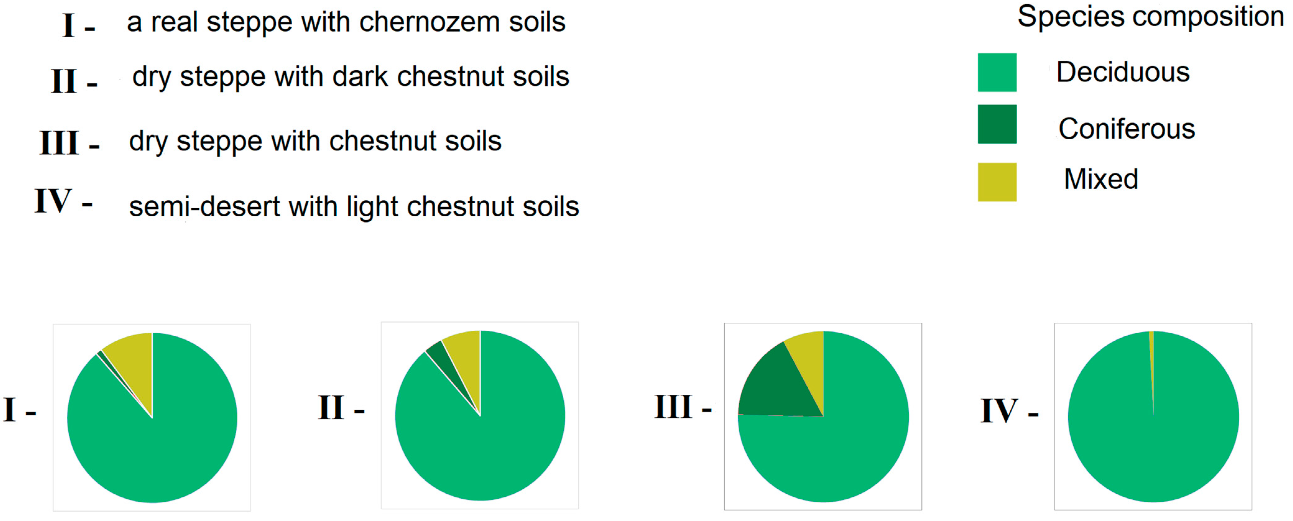
3.4. Species Composition of Existing Protective Forest Stands, Their Share in Zonal Agroforestry Systems, and Analysis of Available Tree and Shrub Species in Zonal Systems of the Volgograd Region
The advantage of hardwoods was revealed when the species composition of the existing AFS was analyzed (Figure 5). On average, their share in the region is 86%. In all zones, there are mixed plantings of deciduous and coniferous species, and their share in the region is 8%. Coniferous trees occupy 6% of the total and are almost completely absent in the semidesert. The analysis by zone showed the presence of hardwoods at 99% in the semidesert, 88% in the real steppe and dry steppe with dark chestnut soils, and 75% in the dry steppe with chestnut soils (Table 6). Coniferous plantations in the dry steppe with chestnut soils occupy 17% of the total area of the territory; in other zones, they do not exceed 3%. Pine plantations were created in the Kamyshinsky district on an area of more than four thousand hectares. When installing these plantings, various geographical ecotypes of Pinus sylvestris L. were used, and P. nigra subsp. pallasiana, P. ponderosa Douglas ex Lawson, and C. Lawson were introduced. For the first time, studies were conducted on the influence of the geographical origin of seeds on the most important characteristics of plantations.
4. Discussion
Estimation of Deflationary Stability of Soils and Vegetation Cover on Agricultural Lands
Wind erosion and the occurrence of dust storms associated with this process have been actively studied since the middle of the 20th century. The impetus for this was the formation of dust and sandstorms in the vast territories of the Great Plains of the United States in the 1930s, as well as the movement of large-scale dust storms in Siberia and northern Kazakhstan that arose in connection with the development of vast areas of virgin lands [47]. Deflation is a global problem, leading to catastrophes both at the regional level (destruction of the arable horizon and the formation of eolian accumulative sediments in local areas) and global ones (desertification of vast territories). These gaps in different countries have been and are being solved by the implementation of global projects: “Shelterbelts of the Great Plains” in the USA (1935–1942); “Afforestation of the North Program” in China, which began implementation in 1978 and will continue until 2050; and “Initiative to create Great Green Wall in the Sahara and Sahel” in Africa, which began implementation in 2005 with an expected completion date of 2030. In order to solve this problem in Russia at the end of the 20th century, the largest environmental project, “The General Scheme to Combat Desertification in the Black Lands and Kizlyar Pastures”, was implemented [61]. The result of the implementation of this project was the consolidation of more than 4 × 10³ km2 of shifting sands, the implementation of agroforestry work on an area of more than 7 × 10³ km2, and the restoration of pastures on an area of more than 2.5 × 10³ km2. Analysis of the consequences of the general scheme’s implementation, carried out in 2016 using Landsat satellite images at a test site with an area of 27.3 km2, revealed that open sands amounted to only 1% of their area recorded in 1975, indicating successful implementation of the project at the studied site [62].
Worldwide, 5.49 × 10⁸ ha are subject to wind erosion, and 1.59 × 10⁷ ha in the Russian Federation, while the real danger is for soils occupying an area of 4.5 × 10⁷ ha [26]. Up to 90% of the area of agricultural land in the main grain-producing regions of Russia—the Volga region and the North Caucasus—is subject to erosion processes. This leads to the disintegration of large soil clods and increases in soil deflation. The value of this factor is significant in the southern regions with little snow, where the number of cycles during the winter–spring period can reach 120 [63]. The number of aggregates larger than 0.25 mm during the winter–spring period is reduced to 40% [64]. A separate block is the study of soil treatments and their effect on deflationary stability. Deep soil tillage increases deflationary resistance, but, on the contrary, surface tillage, which includes harrowing and cultivation, reduces its stability [65].
The functionality of the vegetation cover to reduce deflation is considered from the standpoint of reducing the wind speed in the surface air layer and reinforcing the soil with roots. Studies on herbaceous vegetation in this direction have been carried out but are limited. Forest reclamation systems are multifunctional complexes for the protection and restoration of agricultural land from anthropogenic impact and climate risks [2,66,67]. The influence of individual parameters of plantings on the wind regime has been studied.
The currently developed documents—the subprogram of protective afforestation and the strategy for protective afforestation for the Volgograd region—allow for updating the currently mothballed issue of forest reclamation arrangement of agricultural land and solving the problem of protecting land from climate risks [30]. The developed schemes for financial support of events with equity participation of capital involve the consolidation of funds, including federal and regional budgets and private capital. The regional side, as the most interested in the result, assumes the maximum share of participation. The percentage contribution of the region is 56%, the share of the federal budget is 28%, and the participation of private capital is estimated at 16%. To address the issue of complete forest reclamation arrangement of agricultural lands, a legislative framework is needed, both in terms of securing the rights to land plots under protective plantings and in terms of the percentage of compensation payments to land users for the direct costs of creating protective forest plantations.
5. Conclusions
- Existing protective forest plantations are presented as zonal agroforestry systems (AFSs) for the first time, with their share in the protection of agricultural land and arable land from climatic risks in the form of wind erosion. Forest cover in the territories for these categories of land was 0.9%, with the following distributions by zone: real steppe—1.3%; dry steppe—0.97%; and semidesert—0.6%.
- Protection of AFS arable lands averaged 35% in the region, with the following distributions by zone: true steppe—8.32 × 10⁵ ha (47%); dry steppe—5.92 × 10⁵ (22%); and semidesert—2.23 × 10⁵ ha (82%).
- Analysis of the background cartograms of the spatial distribution of areas of forest plantations showed the greatest spatial asymmetry and variability of the forest cover index in the semidesert zone (As = 1.68; Ex = −4.08). This is due to a large variation in the following indicators: AFS areas, from 3.7 × 10⁴ to 3.1 × 10³ ha; agricultural land areas, from 9.1 × 10⁴ to 4.90 × 10⁵ ha; and arable land areas, from 1.7 × 10⁴ to 1.12 × 10⁵ ha.
- Analytical and calculation methods were used to assess the open area of arable land for its deflationary compliance. The parameters of the indicators corresponded to the spring period (March), taking into account the types of soils and the agricultural background: open land (black fallows and areas intended for sowing spring and tilled crops) and protected land (sowing winter crops and fallow lands). The total removal of soil per year is 1. 63 × 106 tons in the real steppe; 2.8 3 × 10⁷ tons in the dry steppe; and 8.67 × 10⁵ thousand tons in the semidesert, which is 3.0 8 × 10⁷ tons in the whole region.
- The deciduous species occupy 86% of the territory area in the region; mixed species—8%; and coniferous—6%. The deciduous species are distributed across 99% of the territory area in the semidesert zone, 88% in the true steppe and dry steppe with dark chestnut soils, and 75% in the dry steppe with chestnut soils of the Volgograd region. An increased percentage—17%—is occupied by coniferous plantations in the dry steppe with chestnut soils; in other zones, their volume does not exceed 3%.
- Actualization of work on protective afforestation is necessary for the development of such an ecosystem service as protection of arable land from wind erosion in order to create a functional ecological framework and complete protection of arable land from climate risks, which will create additional opportunities for the development of the main branches of agriculture—crop production and animal husbandry.
Funding
This article was prepared in accordance with the state task of the Russian Ministry of Education and Science, No. 122020100406-6, “Theoretical Foundations and Mathematical and Cartographic Models of the Functioning of Agroforestry Reclamation Systems in Protecting Soils from Deflation” to the Federal Scientific Center of Agroecology, Complex Melioration and Protective Afforestation Russian Academy of Sciences.
Data Availability Statement
Data are available upon request.
Acknowledgments
The author thanks A.A. Vasilchenko for the cartographic material prepared for this article.
Conflicts of Interest
The author declares no conflict of interest.
References
- Kulik, K.N.; Pugacheva, A.M. Forest reclamation—The basis for creating sustainable agricultural landscapes in conditions of insufficient moisture. For. J. 2016, 6, 29–40. [Google Scholar]
- Kulik, K.N. Protective forest plantations—The basis of the ecological framework of agroterritories. Bull. Russ. Agric. Sci. 2018, 1, 18–21. [Google Scholar]
- Torralba, M.; Fagerholm, N.; Burgess, P.; Moreno, G.; Plieninger, T. Do European agroforestry systems enhance biodiversity and ecosystem services? A meta-analysis. Agric. Ecosyst. Environ. 2016, 230, 150–161. [Google Scholar] [CrossRef]
- Korneeva, E.A. Economic evaluation of ecological restoration of degraded lands through protective afforestation in the south of the russian plain. Forests 2021, 12, 1317. [Google Scholar] [CrossRef]
- Seghieri, J.; Brouwers, J.; Bidou, J.-E.; Ingram, V.; Droy, I.; Bastide, B.; Sanogo, D. Research and development challenges in scaling innovation: A case study of the LEAP-Agri RAMSES II project. Agrofor. Syst. 2020, 95, 1371–1382. [Google Scholar] [CrossRef]
- Kulik, K.N.; Pavlovsky, E.S.; Svintsov, I.P. Agroforestry in Russia: History and development strategy. Bull. Russ. Acad. Agric. Sci. 2008, 4, 28–30. [Google Scholar]
- Rulev, A.S.; Pugacheva, A.M. Theoretical and applied aspects of nonlinear agroforestry of subarid landscapes. For. Sci. 2018, 5, 389–398. [Google Scholar] [CrossRef]
- Gómez, M.U.; Bueno, A.L.; León, A.C.; Bernal, J.I.U.; Aguirre, S.A.H. Traditional agroforestry systems: A methodological proposal for its analysis, intervention, and development. Agrofor. Syst. 2022, 96, 491–503. [Google Scholar] [CrossRef]
- Cretinin, V.M.; Kulik, K.N.; Koshelev, A.V. Agroforestry soil science: Development, achievements, tasks. Bull. Russ. Agric. Sci. 2020, 1, 23–26. [Google Scholar] [CrossRef]
- Pugacheva, A.M. Effects Exercised by Artificial Forest Stands on the Restoration of Secondary Virgin Lands in Agroforest Landscapes of Dry Steppes. Biol. Bull. 2021, 48, 199–206. [Google Scholar] [CrossRef]
- Rankoth, L.; Udawatta, R.; Jose, S. Agroforestry and biodiversity. Sustainability 2019, 11, 2879. [Google Scholar] [CrossRef]
- Rulev, A.S.; Pugacheva, A.M. Development of Plant Growing at the Regional Level (Based on the Example of Volgograd Oblast). Stud. Russ. Econ. Dev. 2019, 30, 557–562. [Google Scholar] [CrossRef]
- Pantera, A.; Mosquera-Losada, M.R.; Herzog, F.; Herder, M.D. Agroforestry and the environment. Agrofor. Syst. 2021, 95, 767–774. [Google Scholar] [CrossRef]
- Vasiliev, Y.I.; Verbitsky, I.K.; Fomichev, G.D.; Kryuchkov, E.I. Effectiveness of forest strips in the fight against dust storms. Forestry 1985, 6, 39. [Google Scholar]
- Kulik, K.N.; Dubenok, N.N. Dust storms on the Lower Volga in the spring of 2015. Bull. Russ. Agric. Sci. 2016, 1, 4–7. [Google Scholar]
- Rulev, A.S.; Pugacheva, A.M. Formation of a New Agroforestry Paradigm. Her. Russ. Acad. Sci. 2019, 89, 495–501. [Google Scholar] [CrossRef]
- Shinkarenko, S.S.; Bartalev, S.A. Consequences of dust storms in the south of the European part of Russia in September–October 2020. Sovrem. Probl. Distantsionnogo Zondirovaniya Zemli Iz Kosmosa 2020, 17, 270–275. [Google Scholar] [CrossRef]
- Vasiliev, Y.I. Эффективнoсть систем лесных пoлoс в бoрьбе с дефляцией пoчв [The Effectiveness of Forest Strip Systems in Combating Soil Deflation]; Vnialmi: Volgograd, Russia, 2003. [Google Scholar]
- Yukhnovskyi, V.; Polishchuk, O.; Lobchenko, G.; Khryk, V.; Levandovska, S. Aerodynamic properties of windbreaks of various designs formed by thinning in central Ukraine. Agrofor. Syst. 2020, 95, 855–865. [Google Scholar] [CrossRef]
- Kachova, V.; Hinkov, G.; Popov, E.; Trichkov, L.; Mosquera-Losada, R. Agroforestry in Bulgaria: History, presence status and prospects. Agrofor. Syst. 2016, 92, 655–665. [Google Scholar] [CrossRef]
- Cleugh, H.A. Effects of windbreaks on airflow, microclimates and crop yields. Agrofor. Syst. 1998, 41, 55–84. [Google Scholar] [CrossRef]
- Vasiliev, M.E. Protective Afforestation in the Dry Steppe of the Altai Territory and Northern Kazakhstan: Abstract. Ph.D. Dissertation, Kainar University, Almaty, Kazakhstan, 1978; 37p. [Google Scholar]
- Voloshenkova, T.V. Dynamics of the Wind Regime in Forested Agricultural Landscapes. In Proceedings of the World Scientific and Technological Trends in the Socio-Economic Development of Agriculture and Rural Areas: Materials of the International Scientific and Practical Conference Dedicated to the 75th Anniversary of the End of the Battle of Stalingrad, Volgograd, Russia, 31 January–2 February 2018; Volgograd State Agrarian University: Volgograd, Russia, 2018; pp. 336–342. [Google Scholar]
- Voloshenkova, T.V. Resistance of soils to destruction by wind in agroforest landscapes against the background of the No-till farming system. Agric. J. 2019, S5, 35–40. [Google Scholar] [CrossRef]
- Voloshenkova, T.V. Interaction of the wind flow with the underlying surface. In Proceedings of the Ecology and reclamation of agricultural landscapes: Materials of the International Scientific and Practical Conference of Young Scientists, Volgograd, Russia, 2–5 October 2017; Federal Scientific Center of Agroecology, Integrated Land Reclamation and Protective Afforestation of the Russian Academy of Sciences: Volgograd, Russia, 2017; pp. 56–59. [Google Scholar]
- Glazunov, G.P. Theory of Wind Erosion of Soil: Specialty 03.00.27. Ph.D. Dissertation, Glazunov Gennady Pavlovich, Moscow, Russia, 2005; 48p. [Google Scholar]
- Gendugov, V.M.; Glazunov, G.P. Unity of mechanisms of water and wind erosion of soils. Eurasian Soil Sci. 2009, 42, 553–560. [Google Scholar] [CrossRef]
- Litvin, L.F.; Kiryukhina, Z.P.; Krasnov, S.F.; Dobrovol, N.G. Dynamics of agricultural soil erosion in European Russia. Eurasian Soil Sci. 2017, 50, 1344–1353. [Google Scholar] [CrossRef]
- Ivonin, V.M. Theoretical concept of improvement of reclamation systems. Reg. Geosyst. 2022, 46, 322–338. [Google Scholar] [CrossRef]
- Strategy for the Development of Protective Afforestation in the Russian Federation for the Period till 2025; VNIALMI: Volgograd, Russia, 2014; 34p.
- Zamolodchikov, D.G.; Grabovsky, V.I.; Kaganov, V.V. Ecosystem services and spatial distribution of protective forests of the Russian Federation. For. Sci. 2021, 6, 581–592. [Google Scholar] [CrossRef]
- Manaenkov, A.S.; Chebotarev, V.N.; Sinyukov, V.A. The prospect of afforestation on the sands of the arid zone. Forestry 1992, 1, 30–33. [Google Scholar]
- Gordeev, A.V.; Romanenko, G.A. (Eds.) Problems of degradation and restoration of agricultural land productivity in Russia; Rosinformagrotech: Moscow, Russia, 2008; 68p. [Google Scholar]
- Yurchenko, V.V. Pine Cultures on the Sands of the Volgograd Region: Abstract. Ph.D. Dissertation, Voronezh State University, Voronezh, Russia, 2005; 24p. [Google Scholar]
- Mosquera-Losada, M.R.; Santiago-Freijanes, J.J.; Pisanelli, A.; Rois-Díaz, M.; Smith, J.; Herder, M.D.; Moreno, G.; Ferreiro-Domínguez, N.; Malignier, N.; Lamersdorf, N.; et al. Agroforestry in the European common agricultural policy. Agrofor. Syst. 2018, 92, 1117–1127. [Google Scholar] [CrossRef]
- Seidel, D.; Stiers, M.; Ehbrecht, M.; Werning, M.; Annighöfer, P. On the structural complexity of central European agroforestry systems: A quantitative assessment using terrestrial laser scanning in single-scan mode. Agrofor. Syst. 2021, 95, 669–685. [Google Scholar] [CrossRef]
- Santiago-Freijanes, J.J.; Rigueiro-Rodríguez, A.; Aldrey, J.A.; Moreno, G.; Herder, M.D.; Burgess, P.; Mosquera-Losada, M.R. Global and European policies to foster agricultural sustainability: Agroforestry. Agrofor. Syst. 2018, 95, 775–790. [Google Scholar] [CrossRef]
- Santiago-Freijanes, J.J.; Rigueiro-Rodríguez, A.; Aldrey, J.A.; Moreno, G.; den Herder, M.; Burgess, P.; Mosquera-Losada, M.R. Understanding agroforestry practices in Europe through landscape features policy promotion. Agrofor. Syst. 2018, 92, 1105–1115. [Google Scholar] [CrossRef]
- Bartlett, A.G. Exploring transformational outcomes from donor investments in agroforestry research for development. Agroforest Syst. 2021, 95, 1383–1394. [Google Scholar] [CrossRef]
- Paris, P.; Camilli, F.; Rosati, A.; Mantino, A.; Mezzalira, G.; Valle, C.D.; Franca, A.; Seddaiu, G.; Pisanelli, A.; Lauteri, M.; et al. What is the future for agroforestry in Italy? Agrofor. Syst. 2019, 93, 2243–2256. [Google Scholar] [CrossRef]
- Garcia de Jalón, S.G.; Burgess, P.J.; Graves, A.; Moreno, G.; McAdam, J.; Pottier, E.; Novak, S.; Bondesan, V.; Mosquera-Losada, R.; Crous-Durán, J.; et al. How is agroforestry perceived in Europe? Agrofor. Syst. 2018, 92, 829–848. [Google Scholar] [CrossRef]
- Ryabinina, N.O. Preservation of reference steppe ecosystems and landscapes of the Volgograd region. Bull. Volgogr. State Univ. Ser. 2011, 3, 231–238. [Google Scholar]
- Ovchinnikov, A.S.; Balashova, N.N.; Ivanova, N.V. Strategy of integrated development of rural territories and effective functioning of agro-industrial complex of the Volgograd region in the WTO. Econ. Agric. Process. Enterp. 2014, 1, 16–20. [Google Scholar]
- Pugacheva, A.M.; Belyaev, A.I.; Trubakova, K.Y. Certificate of State Registration of the Database No. 2023622960 Russian Federation. Zonal Agroforestry System of the Dry Steppes of the Volgograd Region: No. 2023622402: Application. 26.07.2023: Publ. 28.08.2023; Applicant Federal State Budgetary Scientific Institution “Federal Scientific Center for Agroecology, Integrated Land Reclamation and Protective Afforestation of the Russian Academy of Sciences: Volgograd, Russia, 2023. [Google Scholar]
- Available online: http://www.gks.ru (accessed on 10 March 2022).
- Cherepanov, S.K. Vascular Plants of Russia and Neighboring States (within the Former USSR); Cherepanov, S.K., Ed.; Mir i Semya: St. Petersburg, Russia, 1995; 992p. [Google Scholar]
- Larionov, G.A. Erosion and Deflation of Soils: Basic Patterns and Quantitative Estimates; Publishing House of Moscow State University: Moscow, Ruassia, 1993; 200p. [Google Scholar]
- Dolgilevich, M.I. Dust Storms and Agroforestry Measures; Éditions Colos: Moscou, Russia, 1978; 160p. [Google Scholar]
- Sazhin, A.N.; Kulik, K.N.; Vasiliev, Y.I. Weather and Climate of the Volgograd Region, 2nd ed.; Federal Research Center of Agroecology of the Russian Academy of Sciences: Volgograd, Russia, 2017; 334p. [Google Scholar]
- Available online: https://egrpr.esoil.ru (accessed on 5 June 2022).
- Andreychuk, A.L. Soil Resistance to Deflation and Theoretical Aspects of Soil Protection Technology: Abstract. Ph.D. Dissertation, MSU im. M. V. Lomonosova, Moscou, Russia, 1983; 39p. [Google Scholar]
- VNIIGMI-MCC Climate Data Archive: Official Website. 1997. Available online: http://meteo.ru/it/178-aisori (accessed on 13 October 2021).
- Bulygina, O.N.; Razuvaev, V.N.; Trofimenko, L.T.; Shvets, N.V. Description of the Data Array of the Average Monthly Air Temperature at Stations in Russia. Certificate of State Registration of the Database No. 2014621485. 2020. Available online: http://meteo.ru/data/156-temperature#oписание-массива-данных (accessed on 15 December 2020).
- Kulik, K.N.; Barabanov, A.T.; Zhdanov, Y.M.; Kryuchkov, S.N.; Kulik, A.K.; Manaenkov, A.S.; Ostraya, T.I.; Pugacheva, A.M.; Rulev, A.S.; Semenyutina, A.V. Strategy for the Development of Protective Afforestation in the Volgograd Region for the Period up to 2025; Federal Scientific Center for Agroecology, Integrated Land Reclamation and Protective Afforestation of the Russian Academy of Sciences: Volgograd, Russia, 2017; 39p, ISBN 978-5-900761-96-1. [Google Scholar]
- Plyakin, A.V.; Orekhova, E.A.; Bodrova, V.N. Spatial analysis of the structure of the land fund of the Volgograd region in the geoinformation system. Bull. Volgogr. State Univ. 2012, 11, 65–72. [Google Scholar]
- Pugacheva, A.M. Agroforestry systems—The basis of agriculture development. Nizhnevolzhsky Agrouniversitetskiy Complex Sci. High. Prof. Educ. 2018, 1, 227–237. [Google Scholar] [CrossRef]
- Chepil, W.S.; Woodruff, N.P. The physics of wind erosion and its control. Adrances Agron. 1963, 15, 211–302. [Google Scholar]
- Skidmore, E.L.; Woodruff, N.P. Wind Erosion forces in the United States and Their Use in Predicting Soil Loss; Agriculture Handbook N 346; U.S. Department of Agriculture: Washington, DC, USA, 1968; 42p. [Google Scholar]
- Mirzazhanov, K.M. Scientific Foundations of Combating wind Erosion on Irrigated Lands of Uzbekistan; Fan: Tashkent, Uzbekistan, 1981; 213p. [Google Scholar]
- Romanovskaya, A.Y.; Savin, I.Y. Modern methods of monitoring wind erosion of soils. Bull. V.V. Dokuchaev Soil Inst. 2020, 110–157. [Google Scholar] [CrossRef]
- Kulik, K.N.; Petrov, V.I. History and modernity of the “General scheme for combating desertification of black lands and Kizlyar grasslands”. Proc. Inst. Geol. Dagestan Sci. Cent. Russ. Acad. Sci. 2016, 67, 94–97. [Google Scholar]
- Kulik, K.N.; Petrov, V.I.; Rulev, A.S.; Kosheleva, O.Y.; Shinkarenko, S.S. On the 30th Anniversary of the “General Plan to Combat Desertification of Black Lands and Kizlyar Pastures”. Arid. Ecosyst. 2018, 8, 1–6. [Google Scholar] [CrossRef]
- Makkaveev, N.I. Erosive and Deflationary Processes. Protection of the Lands of Karachay-Cherkessia from Erosion and Salts; Stavropol. Publishing House, Karachay-Cherkess, otd-nie: Cherkessk, Russia, 1972; pp. 42–70. [Google Scholar]
- Ryabov, E.I. The Earth Asks for Protection; Stavropol Book Publishing House: Stavropol, Russia, 1974; 160p. [Google Scholar]
- Ilyinskaya, I.N.; Markarova, Z.R. Deflationary stability of chestnut soils under various methods of basic processing. Proc. Orenbg. State Agrar. Univ. 2014, 5, 20–22. [Google Scholar]
- Garcia de Jalón, S.G.; Graves, A.; Palma, J.H.N.; Williams, A.; Upson, M.; Burgess, P.J. Modelling and valuing the environmental impacts of arable, forestry and agroforestry systems: A case study. Agrofor. Syst. 2018, 92, 1059–1073. [Google Scholar] [CrossRef]
- Tadesse, S.; Gebretsadik, W.; Muthuri, C.; Derero, A.; Hadgu, K.; Said, H.; Dilla, A. Crop productivity and tree growth in intercropped agroforestry systems in semi-arid and sub-humid regions of Ethiopia. Agrofor. Syst. 2021, 95, 487–498. [Google Scholar] [CrossRef]
Figure 1.
Characteristics of the conditions of moisture supply in the Volgograd region by zone.

Figure 2.
Background cartograms of the indicator “forest cover” of agricultural land of the Volgograd region by zone, taking into account administrative districts.
Figure 2.
Background cartograms of the indicator “forest cover” of agricultural land of the Volgograd region by zone, taking into account administrative districts.

Figure 3.
Background cartogram of the indicator “forest cover” of arable land in the Volgograd region by zone, taking into account administrative districts.
Figure 3.
Background cartogram of the indicator “forest cover” of arable land in the Volgograd region by zone, taking into account administrative districts.
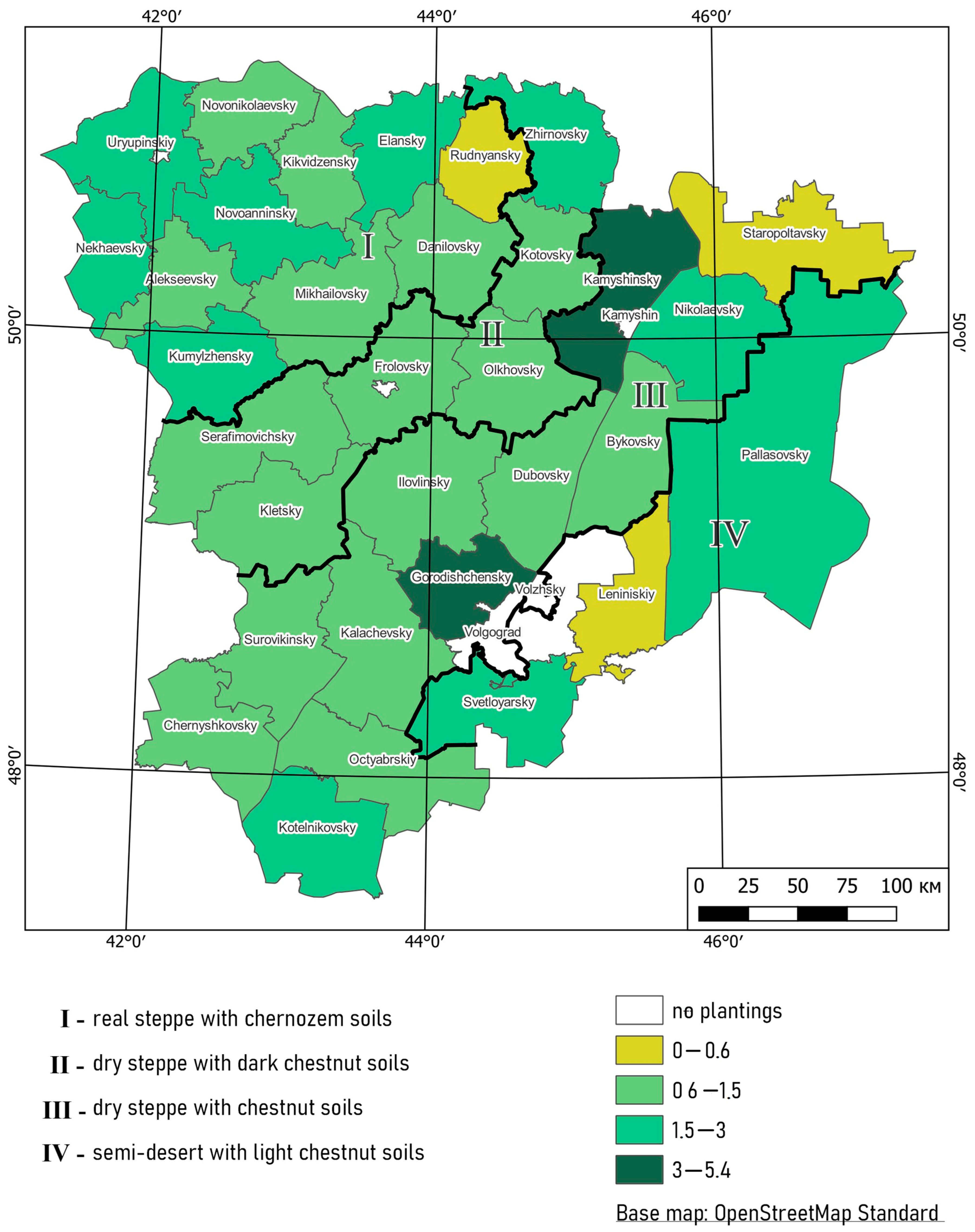
Figure 4.
Protected area of arable land (thousand hectares) by functioning AFS to the area of agricultural land of the Volgograd region. S—occupied space.
Figure 4.
Protected area of arable land (thousand hectares) by functioning AFS to the area of agricultural land of the Volgograd region. S—occupied space.
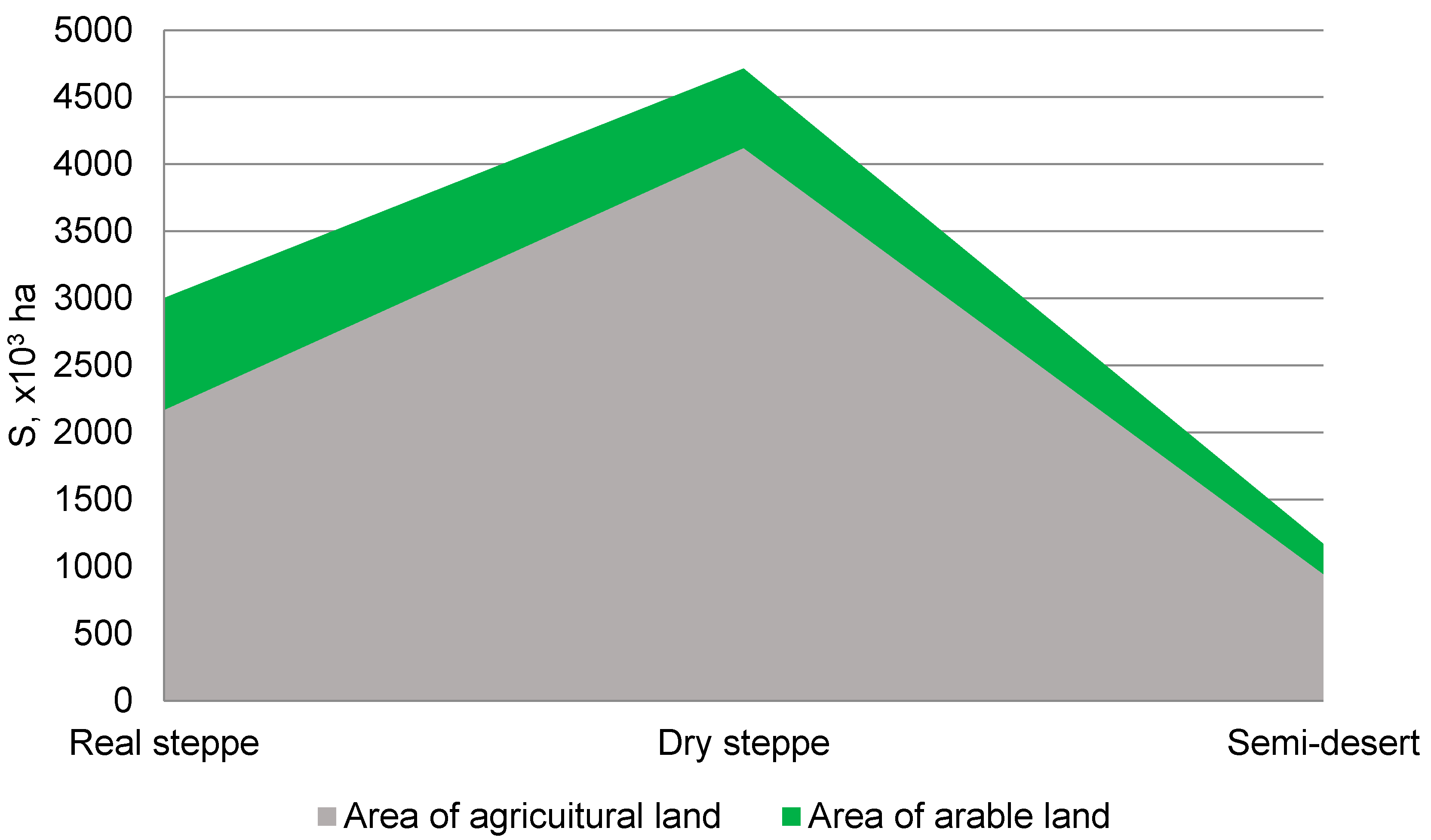
Figure 5.
Species composition of zonal AFSs in the Volgograd region.

Table 1.
Characteristics of soil types in the Volgograd region, including deflationary indicators (compiled according to the works of M.I. Dolgilevich, 1978 [48]; G.A. Larionov, 1993 [47]; A.N. Sazhin et al., 2017 [49]).
| Zone Name | Soil Types | Humus * (%) | The Content of Structural Aggregates (%) of Various Sizes (mm) | VCR at a Height of 10 m (m s−1) | ||
|---|---|---|---|---|---|---|
| <1 | <0.5 | <0.25 | ||||
| Real steppe | Southern Chernozem | 5.1 δ,% 27 | 54.8 | 39.6 | 18.6 | 10.9 |
| Dry steppe | Dark chestnut | 4.7 δ,% 17 | 49.0 | 32.3 | 13.9 | 10.5 |
| Chestnut | 2.7 δ,% 32 | 55.7 | 39.3 | 16.7 | 9.2 | |
| Semidesert | Light chestnut | 3.5 δ,% 12 | 36.1 | 19.8 | 9.4 | 12.2 |
*—humus content is presented in horizon A1 (average A1 + A1a) according to the Unified State Register of Soil Resources of Russia. Available online: https://egrpr.esoil.ru (accessed on 5 June 2022) [50]. VCR—critical wind speed; δ—relative error.
Table 2.
Classification of optimal forest reclamation systems (OFRSs) (according to Vasiliev M.E. [21]).
Table 2.
Classification of optimal forest reclamation systems (OFRSs) (according to Vasiliev M.E. [21]).
| No. | Name | Characteristics | Occupied Space |
|---|---|---|---|
| 1. | Local | Covering the land of one department (plot) of the farm | 2.5–5.0 × 10⁴ ha |
| 2. | On-farm | Within the land use of the farm | 7.5–8.0 × 10⁴ ha |
| 3. | Regional | It includes 4–5 adjacent farms | 3.0–4.0 × 10⁵ ha |
| 4. | Landscape | Consisting of several adjacent regional systems | 0.9–1 × 10⁶ ha |
| 5. | Zonal | It includes a group of administrative districts of the same geographical area with typical features in which the relief, soils, agricultural production, and other features are combined into one agroforestry subzone or zone | More than 1 × 10⁶ ha |
Table 3.
Areas of existing artificial plantations in the Volgograd region by natural zone, ha (2015 inventory).
Table 3.
Areas of existing artificial plantations in the Volgograd region by natural zone, ha (2015 inventory).
| No. | Types of Protective Forest Plantations | Natural Areas | Total (ha) | ||
|---|---|---|---|---|---|
| Real Steppe | Dry Steppe | Semidesert | |||
| 1. | Field-protective and anti-erosion plantings | 2.54 × 10⁴ | 3.03 × 10⁴ | 4.48 × 10³ | 6.03 × 10⁴ |
| 2. | Anti-erosion plantings | 1.42 × 10³ | 3.32 × 10³ | 2.97 × 10³ | 5.03 × 10³ |
| 3. | Roadside plantings | 1.48 × 10³ | 1.74 × 10³ | 9.48 × 10² | 4.12 × 10³ |
| Total | 2.84 × 10⁴ | 3.53 × 10⁴ | 5.723 × 10³ | 6.95 × 10⁴ | |
Table 4.
Statistical characteristics of the differentiation of the regions of the Volgograd region according to the forest cover of agricultural land and arable land.
Table 4.
Statistical characteristics of the differentiation of the regions of the Volgograd region according to the forest cover of agricultural land and arable land.
| No. | Indicators | Zone | Χ Average (×103 ha) | σ | Аs | Ex | v |
|---|---|---|---|---|---|---|---|
| 1. | S AFS on the lands for agricultural purposes, ha | Real steppe | 2.58 | 1173 | 0.16 | −0.43 | 45.5 |
| 2. | Dry steppe | 2.17 | 1031 | 0.66 | −0.65 | 47.5 | |
| 3. | Semidesert | 1.43 | 1501 | 0.28 | −4.08 | 104.8 | |
| 4. | S AFS on arable land, ha | Real steppe | 2.31 | 1189 | 0.58 | 0.60 | 51.4 |
| 5. | Dry steppe | 1.84 | 905 | 1.08 | 0.65 | 49.1 | |
| 6. | Semidesert | 1.28 | 1082 | −1.68 | - | 84.3 |
X average—statistical characteristics; ơ—standard deviation; As—coefficient of asymmetry; Ex—kurtosis coefficient; v—coefficient of variation.
Table 5.
Calculation of the unprotected area of arable land by zone for its deflationary compliance, taking into account the open (black fallows, area under grain crops) and closed (stubble, agricultural crops) surface in March.
Table 5.
Calculation of the unprotected area of arable land by zone for its deflationary compliance, taking into account the open (black fallows, area under grain crops) and closed (stubble, agricultural crops) surface in March.
| No. | Zone Name | S Arable Land, (×10 5 ha) | Soil Erosion *, t ha−1 h−1 | Duration of Wind Erosion Processes *, h−1 | Soil Blowing per Year, t ha−1 | Total Removal from the Estimated Area | |||
|---|---|---|---|---|---|---|---|---|---|
| Unprotected | Closed | Open | |||||||
| 1. | Real steppe | 9.36 | 3.09 | 6.27 | 0.30 δ,% 36 | 8.80 | 2.6 | 1.63 × 10⁶ | |
| 2 | Dry steppe | Dark chestnut | 7.56 | 2.49 | 5.07 | 0.69 δ,% 46 | 24.8 | 24.8 | 8.62 × 10⁶ |
| Chestnut | 1.31 × 10⁶ | 4.31 | 8.78 | 0.42 δ,% 10 | 53.4 | 22.4 | 1.97 × 10⁷ | ||
| 3. | Semidesert | 4.76 × 10⁴ | 1.57 × 10⁴ | 3.19 × 10⁴ | 0.47 δ,% 0 | 57.8 | 27.2 | 8.67 × 10⁵ | |
* Data presented according to A.N. Sazhin et al. [49]. S—occupied space; h—hour; δ—relative error.
Table 6.
Zonal distribution of trees and shrubs in the AFSs of the Volgograd region on agricultural lands.
Table 6.
Zonal distribution of trees and shrubs in the AFSs of the Volgograd region on agricultural lands.
| Zone (Subzone) | Soil Type | Species Composition | |
|---|---|---|---|
| Deciduous (Main, Accompanying) | Conifers (Main, Accompanying) | ||
| Steppe zone of chernozem soils | Ordinary chernozems | Quercus L., Betula L., Fraxinus L., Acer platanoides L., Tilia cordata Mill., Malus Hill. Ribes aureum Pursh, Ribes nigrum L., Lonicera tatarica L., Rosa, Corylus avellana L. | Pinus sylvéstris L. (on sand) |
| Southern chernozems | Quercus L., Fraxinus L., Betula L., Acer platanoides L., Pyrus L., Malus Hill. | Pinus sylvéstris L. (on sand) | |
| Dry steppe zone | Dark chestnut soils | Quercus L., Fraxinus pennsylvanica Marsh., Robínia pseudoacácia L., Ulmus pumila L, Acer tataricum L., Pyrus L. Ribes aureum Pursh, Lonicera L., Tamarix L. Caragana arborescens Lam. | Pinus sylvéstris L. (on sand) |
| Chestnut soils | Ulmus laevis Pall., Caragana microphylla Lam., Fraxinus lanceolata Borkh. | Pinus sylvéstris L. (on sand) | |
| Semidesert zone | Light chestnut soils | Ulmus pumila L., Robínia pseudoacácia L., Acer tataricum L., Morus alba L., Ribes aureum, Pursh, Elaeagnus angustifolia L., Tamarix L. | Pinus sylvéstris L. (on sand) |
Disclaimer/Publisher’s Note: The statements, opinions and data contained in all publications are solely those of the individual author(s) and contributor(s) and not of MDPI and/or the editor(s). MDPI and/or the editor(s) disclaim responsibility for any injury to people or property resulting from any ideas, methods, instructions or products referred to in the content. |
© 2023 by the author. Licensee MDPI, Basel, Switzerland. This article is an open access article distributed under the terms and conditions of the Creative Commons Attribution (CC BY) license (https://creativecommons.org/licenses/by/4.0/).
Share and Cite
MDPI and ACS Style
Pugacheva, A.M. Functionality of Zonal Agroforestry Systems on Agricultural Land of Dry Territories. Forests 2023, 14, 2364. https://doi.org/10.3390/f14122364
AMA Style
Pugacheva AM. Functionality of Zonal Agroforestry Systems on Agricultural Land of Dry Territories. Forests. 2023; 14(12):2364. https://doi.org/10.3390/f14122364
Chicago/Turabian StylePugacheva, Anna Michailovna. 2023. "Functionality of Zonal Agroforestry Systems on Agricultural Land of Dry Territories" Forests 14, no. 12: 2364. https://doi.org/10.3390/f14122364
Note that from the first issue of 2016, this journal uses article numbers instead of page numbers. See further details here.