Abstract
The integration of shared autonomous vehicles into historic urban areas presents both opportunities and challenges. In heritage-rich environments like very old Asian (such as Suzhou old town, which serves as a use case example) or European (especially Mediterranean coastal cities) areas—characterized by narrow alleys, dense development, and sensitive cultural landscapes—shared autonomous vehicle adoption raises critical spatial and social questions. This study employs a qualitative, user-centered approach based on the ripple model to examine residents’ perceptions across four dimensions: residential patterns, parking land use, regional accessibility, and street-level infrastructure. Semi-structured interviews with 27 participants reveal five key findings: (1) public trust depends on transparent decision-making and safety guarantees; (2) shared autonomous vehicles may reshape generational residential clustering; (3) the short-term parking demand remains stable, but the long-term reuse of space is feasible; (4) shared autonomous vehicles could enhance accessibility in historic cores; (5) transport systems may evolve toward intelligent, human-centered designs. Based on these insights, the study proposes three strategies: (1) transparent risk assessment using explainable artificial intelligence and digital twins; (2) polycentric development to diversify land use; (3) hierarchical street retrofitting to balance mobility and preservation. While this study is limited by its qualitative scope and absence of simulation, it offers a framework for culturally sensitive, small-scale interventions supporting sustainable mobility transitions in historic urban contexts.
1. Introduction
The rapid development of the global economy and society has led to the continuous concentration of urban populations, resulting in the ongoing expansion of urban areas [1]. The number of urban residents has increased from 751 million in 1950 to 4.2 billion in 2018. The global average urbanization rate has reached 55%, and it is projected that, by 2050, the urban population will increase by an additional 2.5 billion, pushing the average urbanization rate to 68% [2]. In China, the urbanization rate had already surpassed 60% by 2019. This accelerated urbanization, coupled with rapid population growth, has placed considerable pressure on urban land resources—a challenge that is particularly severe in old town districts. As a representative of China’s new first-tier cities, Suzhou is now facing significant land supply and demand conflicts triggered by urbanization [3]. In response, national policy guidelines in China stipulate that non-motorized transportation modes—such as walking, cycling, and integrated public transit—should account for no less than 75% of the modal share within urban passenger transport systems. Furthermore, walking and cycling should comprise at least 80% of intra-urban trips [4]. However, according to traffic management statistics from public security departments across China, the number of privately owned vehicles has continued to rise steadily in recent years [5] (Figure 1). Simultaneously, the modal share of public transportation has shown a declining trend globally, especially in the aftermath of the COVID-19 pandemic [6]. At present, the usage rate of sustainable transport modes such as walking, cycling, and public transportation remains lower than that of private vehicles. Issues such as insufficient safety, convenience, and comfort in sustainable travel modes contribute to the relatively low adoption of public transport [7]. Moreover, the right of way for sustainable transportation users is often overlooked, and urban street space is frequently occupied by motorized traffic, further weakening the position of sustainable urban mobility in the long term [8].

Figure 1.
Car ownership in Suzhou.
According to a projection by Goldman Sachs, autonomous vehicles (AVs) are expected to account for 50% of all vehicles on the road by 2040 [9], while the Institute of Electrical and Electronic Engineers (IEEE) anticipates that, by around 2050, AVs could constitute as much as 90% of the vehicle fleet [10]. Autonomous vehicle technology is evolving rapidly and encompasses a wide range of applications. To clarify the standards of “driving automation levels”, the Society of Automotive Engineers (SAE) International has developed a classification system that defines six levels of driving automation [11]:
- L0: No driving automation;
- L1: Driver assistance;
- L2: Partial driving automation;
- L3: Conditional driving automation;
- L4: High driving automation;
- L5: Full driving automation.
Because lower-level AVs (L0–L2) have a limited impact on travel behavior, most current research focuses on high-level AVs, particularly Level 4 vehicles, which can operate without human input under specific conditions, and Level 5 vehicles, which are fully autonomous in all environments [12]. Broadly speaking, AVs can be categorized into three types: privately owned AVs (PAVs), commercially operated SAVs, and government-run autonomous public transit systems [13]. SAVs represent a novel concept that integrates scheduled service models, shared mobility platforms, and various levels of intermodal connectivity [14]. SAVs are self-driving taxi fleets typically operated by commercial service providers. They are particularly attractive to users with a low annual mileage, offering them flexible access to various vehicle types tailored to their needs [15]. As an essential component of future urban transportation systems, SAVs are not only poised to transform individual travel behavior but are also expected to reshape urban spatial structures, land use patterns, and social interactions. However, despite their potential dominance in future urban mobility, there remains a notable mismatch between these emerging vehicle technologies and existing urban transportation infrastructure.
In addition, SAVs can play a pivotal role in addressing the “first-mile” and “last-mile” connectivity challenges within urban transport systems. They are particularly effective in areas underserved by conventional public transit, where they may operate as flexible substitutes for fixed-route services. The key advantages of SAVs in this context include door-to-door service, customizable vehicle types, and intelligent fleet scheduling, all of which contribute to greater spatial coverage and service precision. However, several challenges remain. These include uncertainty in waiting times, inconsistent vehicle conditions, and inadequate responses to emergency situations. Such limitations are largely influenced by platform governance mechanisms and the prevailing norms of public user behavior [15] (Figure 2).

Figure 2.
Operation process of SAV system.
An “old town” is a historically developed core area within a city, often regarded as the origin of urban growth and a central hub for cultural heritage and social activity [16]. These areas, rich in historical and cultural value, serve as vital components of urban memory and identity [17]. However, due to the constraints of historical development, the infrastructure in old towns is often outdated and inadequate in meeting the demands of modern urban life. Currently, urban development in China is undergoing a transformation—from incremental expansion to stock optimization, focusing on improving quality and efficiency. Scholars have pointed out that urban renewal in Suzhou’s old town faces a range of persistent challenges, including unresolved tensions between existing public services and increasing demands for high-quality urban amenities, as well as the need for more effective traffic governance in the old districts [18]. With the rapid advancement of AV technologies, there is growing public anticipation surrounding future mobility possibilities [19].
Stead and Vaddadi [20] argue that the widespread adoption of AVs across the United States could substantially transform existing street configurations. Specifically, if AVs were fully implemented nationwide, approximately 6.63 million kilometers of sidewalks could potentially be widened to 9.1 m, thereby unlocking significant spatial capacity for alternative uses. Under equivalent traffic volumes, SAVs are estimated to reduce the required road space by approximately 11–12% [21] (see Figure 3), highlighting their efficiency in spatial utilization compared to conventional vehicles.
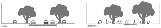
Figure 3.
The changes in road space after integrating SAVs.
A separate study focused on the Melbourne metropolitan region in Australia assessed the spatial impacts of AV deployment under varying scenarios. Assuming a 50% reduction in the typical value of travel time (VTT), the full adoption of PAVs was projected to increase the population density in the outer suburbs, while paradoxically increasing the per capita vehicle kilometers traveled (VKT) by 30% during morning peak hours. Conversely, under a full SAV adoption scenario, the most pronounced population density growth was observed in middle-ring suburbs, with a 9% decrease in per capita VKT [22]. Furthermore, when all AVs are deployed as SAVs, the overall commuting times are projected to decrease by 19% and the total vehicle mileage by 2% [23].
Collectively, these studies suggest that, compared to PAVs, SAVs offer greater potential to alleviate urban congestion and promote the more efficient use of road infrastructure.
SAVs are widely seen as one of the most promising innovations to transform traditional transportation systems [24]. In old town areas, residential environments are often outdated and lack comfort, while the mismatch between emerging transport technologies and existing infrastructure creates an urgent need for transportation system upgrades. Issues such as inadequate infrastructure, poor-quality street networks, and suboptimal travel experiences for both residents and tourists remain pressing concerns. As a renowned historical and cultural city in China, Suzhou’s old town is characterized by its compact street grid, high-density built environment, and abundant cultural heritage. These features present unique challenges for the integration of SAVs into the urban fabric (Figure 4a–c).
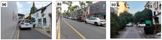
Figure 4.
The current situation of urban space in Suzhou old town. (a) Road space in Suzhou old town, (b) roadside parking space in Suzhou old town, (c) residential human settlement environment in Suzhou old town.
Milakis et al. developed the ripple model to conceptualize the multi-layered impacts of AVs on transportation systems, the urban form, and society [25]. Building upon this framework, Qin et al. refined the model within the domains of urban transport and urban studies, dividing it into three concentric layers: the first layer addresses urban transportation; the second layer focuses on the urban spatial form and land use; and the third layer examines broader impacts on the urban economy, society, and the environment [26]. Based on this extended model, they proposed planning strategies for cities to better respond to the emergence of AVs as a transformative transportation mode. Zhang et al. [12] further elaborated on the second layer of Qin’s ripple model and explored four key dimensions of the urban spatial form and land use: the residential population distribution, parking land allocation, regional accessibility, and the quality of street-level environmental facilities. Their findings provided important insights for large cities in China regarding the spatial implications of AV adoption. The relationship between SAVs and public transportation is pivotal in shaping urban outcomes such as central accessibility, traffic congestion, and carbon emissions. Wang et al. [17] argued that SAVs could contribute positively to the restructuring of urban transport networks, a view consistent with those of other scholars in the field. This paper focuses specifically on the second layer of the ripple model—the urban spatial form and land use—and investigates four core dimensions: the residential population distribution, parking land use, regional accessibility, and street-level environmental facilities (Figure 5).
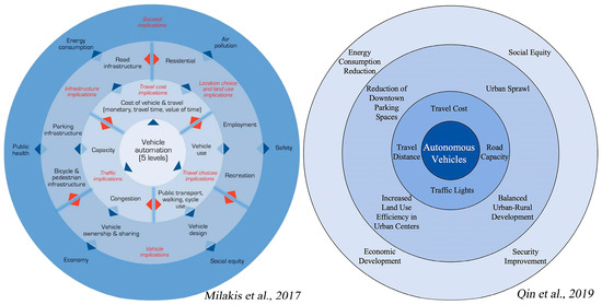
Figure 5.
Comparison of ripple models among different researchers [26,27].
The adoption of SAVs serves as a catalytic force in advancing mobility transitions within historic urban areas. Beyond their technological dimensions, SAVs reshape travel behavior by influencing modal choices, reducing the dependency on private vehicles, and enhancing accessibility through demand-responsive routing. In heritage-sensitive contexts such as Suzhou’s old town, the integration of SAVs may also induce secondary transformations in land use patterns, street design, and spatial allocation. These shifts present a unique opportunity to embed SAV deployment within broader, integrative urban regeneration strategies that align mobility innovation with cultural and spatial conservation goals [28]. The challenge of integrating SAVs into heritage-laden urban cores is not unique to Suzhou. Many historic districts across Europe—particularly in Mediterranean coastal cities such as Valletta, Dubrovnik, and Palermo—face comparable tensions between highly compact spatial morphologies and the demands of intelligent mobility infrastructure. As such, this study aims to generate context-sensitive yet transferable insights that may inform policy and spatial strategies in similarly constrained urban environments worldwide. By articulating the socio-spatial dynamics specific to Suzhou, this research contributes to a broader comparative framework for an understanding of SAV deployment in culturally and physically dense cityscapes.
While an increasing number of studies have focused on the technical dimensions of SAVs—including deep learning-based perception systems, AI-assisted path planning strategies [29], autonomous navigation algorithms, sensor fusion systems, and vehicle-to-everything (V2X) communication platforms [12]—far less scholarly attention has been directed toward their spatial and morphological impacts within historic urban cores. This study aims to address this critical gap by investigating how SAVs, as a socio-technical system, interact with the embedded spatial logics, material constraints, and cultural rhythms of traditional urban environments, using Suzhou’s old town as a representative case.
Research Significance:
- This study contributes to the empirical enrichment of the ripple model by focusing on the user demand within the spatial context of old towns.
- It also explores the potential impacts of SAV technology on the spatial structures of old towns from the perspective of urban residents. Specifically, it proposes adaptive development strategies for Suzhou’s historic districts to promote the organic integration of SAVs with traditional urban environments.
Research Objectives:
- To investigate urban residents’ perceptions in the context of SAVs’ integration into old town environments and to identify key spatial renewal priorities during the transitional phase of technological adoption, based on user-centered insights.
- To provide complementary strategies for spatial optimization in urban stock renewal processes, offering a novel perspective tailored to the unique challenges of old town districts.
Research Novelties:
- While previous studies have examined the impacts of SAVs on urban transportation systems and land use patterns, few have addressed their spatial and socio-cultural implications within the historically layered environments of old town districts.
- Moreover, the majority of existing SAV research remains dominated by simulation-based modeling or large-scale quantitative datasets, often marginalizing the place-based experiences, perceptions, and needs of local residents.
To address these gaps, this study adopts a qualitative, resident-centered framework to investigate the integration of SAVs into heritage urban contexts. By emphasizing the socio-spatial interface between emerging mobility technologies and the traditional urban fabric, this research offers novel insights into the bidirectional adaptation processes required for sustainable and context-sensitive urban transformation.
2. Methodology
2.1. Study Area
This study focuses on the spatial characteristics of the old town of Suzhou as the primary research subject. Suzhou’s historic city center covers an area of approximately 14.2 km2 and has a current population of 252,000 residents, based on official street-level statistical data from 2020 [30]. Although this study utilizes street-level statistical data from Suzhou in 2020, alongside official demographic information from the Seventh National Population Census, the dataset remains both representative and timely. On the one hand, it is the most comprehensive and authoritative demographic dataset currently available, released by national statistical agencies and widely employed in urban planning, policy formulation, and academic research. On the other hand, recent studies have continued to rely on this dataset. For example, Yang et al. (2024) adopted the 2020 census data as the foundational basis in their study on population capacity adjustment and optimization in Suzhou’s old town under the lens of social sustainability [31]. This continued usage highlights the dataset’s relevance and explanatory power regarding the demographic patterns and spatial structures of historic urban areas in the short to medium term. Therefore, in the absence of more detailed follow-up census data, the 2020 dataset remains a reliable foundation for the analysis of residential patterns and mobility behaviors in Suzhou’s old town.
The dominant land uses include residential areas and public administration and service facilities, as well as commercial and business-related functions. The spatial structure of Suzhou’s old town is characterized by a water-oriented urban fabric: rivers form the structural backbone, while roadways are organized around a dual-grid system aligned with the water network [32].
The selection of Suzhou’s old town as the case study is grounded in the following considerations (Figure 6a–c):

Figure 6.
Suzhou old town location. (a) Jiangsu Province, China; (b) map of Suzhou; (c) map of Suzhou old town; (d) Pingjiang Map of Suzhou (1229 AD—the earliest and most complete existing city plan in China).
- Representative Urbanization Dynamics: Suzhou’s urbanization rate has reached 81.72%, marking an increase of 11.65% from the 70.07% recorded in the Sixth National Population Census. During this period, the permanent population grew from 10.45 million to 12.74 million, and the urban population increased from 7.32 million to 10.41 million [33]. As a typical representative of China’s densely urbanized regions and a national pilot city for urban–rural integration, Suzhou reflects the broader transition from separation to integration in urban–rural relations and the rationalization of planning paradigms [34]. Therefore, the study of Suzhou’s old town offers a valuable reference for similar contexts in East Asia and beyond.
- Strong Regional Identity and Historic Continuity: Suzhou’s old town retains a highly distinctive spatial identity. Over the past two millennia, its urban form and location have remained remarkably stable [32]. When compared to the historic “Pingjiang Map”, the city’s overall framework, primary water systems, and historic bridges and landmarks remain largely unchanged—an extremely rare phenomenon globally (see Figure 6d). Additionally, the old town’s traditional architectural façades, built heritage, and social customs embody rich cultural value, forming a diverse and distinctive urban landscape [34]. As such, investigating the spatial adaptation of SAVs in Suzhou’s old town offers valuable insights not only for local development but also for the adaptive renewal of historic urban cores across East Asia and other parts of the world.
2.2. Data Collection
This study adopts a general qualitative research design [35], aiming to explore, from both descriptive and interpretive perspectives, how urban residents currently perceive the use of SAVs and how they subjectively interpret the potential spatial impacts of this emerging technology on old town environments. While relatively underutilized in studies concerning the integration of SAVs into urban space—especially within historical urban cores—this method offers significant flexibility, allowing for a deeper investigation into the ways that SAVs may influence old towns’ spatial structures from a user-centered perspective (Figure 7).

Figure 7.
Research framework.
This qualitative inquiry is structured around the second layer of the ripple model, which includes four key dimensions related to urban spatial transformation: (1) the residential population distribution, (2) parking land use, (3) regional accessibility, and (4) the quality of street-level infrastructure. Guided by this framework, a questionnaire was developed to inform a series of semi-structured, in-depth interviews designed to analyze perceived spatial impacts.
Data were collected through individual interviews, each lasting approximately 60 min. The core interview question was “From the user’s perspective, what are the potential impacts of SAVs on the spatial structure of old town areas?”
Participants were briefed on the specific focus on SAVs as distinct from privately owned AVs. This clarification was reiterated during the interviews to ensure consistent understanding.
The interview questions were developed under the four aforementioned themes—the residential population, parking land use, regional accessibility, and street-level environmental facilities—and were refined through brainstorming to ensure that the participants provided spatially relevant responses (Table 1).
The interview protocol consisted of the following major sections:
- Sociodemographic information: including gender, age, possession of a personal driver’s license, and duration of residence in Suzhou [36];
- Basic understanding of autonomous driving technology;
- Urban spatial issues related to the integration of SAVs, based on the ripple model framework;
- Open-ended questions aimed at eliciting broader perspectives.
A pilot study involving three interviewees was conducted to refine the interview process. During the pilot phase, it was observed that participants often confused the concepts of “AVs” and “SAVs”. To address this, later interviews explicitly emphasized that the discussion focused specifically on SAVs.

Table 1.
Semi-structured interview questions based on the ripple model (second circle).
Table 1.
Semi-structured interview questions based on the ripple model (second circle).
| Element Layer | Interview Questions | Objective | Source |
|---|---|---|---|
| Basic Understanding | How familiar are you with SAVs? Have you ever experienced riding in an AVs? | To assess respondents’ basic level of knowledge about SAVs. | Etminani-Ghasrodashti et al., 2021 [37] |
| If SAVs were introduced more extensively in Suzhou’s old town, would you prefer using SAVs for your daily travel? Why or why not? | To explore whether the introduction of SAVs may alter residents’ or tourists’ travel behavior. | Etminani-Ghasrodashti et al., 2021 [37] | |
| Residential Population | Do you think the development of SAVs technology would influence your residential location choice? Would you be more willing to live in the city center or suburbs? Why? | To examine whether SAVs could affect the residential distribution, such as encouraging suburban living due to reduced commuting pressure. | Zhang W. et al., 2022 [12]; Zhang and Guhathakurta, 2018 [23] |
| Parking Land Use | Do you think the widespread use of SAVs would reduce the need for parking in the old town? Why or why not? | To investigate the potential reduction in parking demand and its implications for urban land use. | Zhang W. et al., 2022 [12]; Zhang W. et al., 2015 [38] |
| If parking demands were reduced, what types of facilities or spaces would you prefer to see replacing parking lots? | To collect preferences regarding alternative uses of urban land currently occupied by parking facilities. | Xia et al., 2021 [39] | |
| Regional Accessibility | In your opinion, will SAVs change the layout or location of parking facilities in the future? | To explore public perceptions of how SAVs may reshape the existing parking infrastructure. | Xia et al., 2021 [39]; Gu et al., 2023 [40] |
| Do you think SAVs development will improve the accessibility of certain urban areas? Which areas might become more accessible? | To determine whether SAVs might enhance access to remote or peripheral locations, possibly affecting mobility choices. | Milakis et al., 2017 [27] | |
| If SAVs improve accessibility across the city, what impacts would you hope to see on the distribution of commercial, residential, or public service facilities? | To explore expectations regarding how improved connectivity might influence the spatial distribution of urban functions. | Qin et al., 2019 [26]; Zhang W. et al., 2022 [12] | |
| Do you think SAVs will affect how easily tourists can access various urban attractions? Would it change your travel plans? Why or why not? | To understand the potential of SAVs to reshape tourism mobility and influence travel decisions. | Qin et al., 2019 [26]; Zhang W. et al., 2022 [12] | |
| Street Infrastructure and Environment | In your opinion, will the prevalence of SAVs change the design of city streets? | To explore whether the introduction of SAVs will create new demands for street layouts, especially regarding pedestrians and cyclists. | Qin et al., 2019 [26] |
| What aspects of the street environment would you like SAVs to help improve? | To understand expectations for SAVs in improving urban streetscapes (e.g., noise reduction, increased safety, environmental quality). | Ambühl et al., 2016 [21]; Zhang W. et al., 2022 [12] | |
| If SAVs significantly reduce traffic accidents, what changes do you think may occur in street infrastructure? | To guide a discussion of the potential reconfiguration of safety infrastructure and street design. | Qin et al., 2019 [26]; Zhang W. et al., 2022 [12] | |
| With the advancement of SAVs, what changes do you anticipate in the overall urban traffic layout? | To examine the broader urban planning implications of SAV integration, especially in terms of road design and space allocation. | Heinrichs, 2016 [41]; Zhang W. et al., 2022 [12] | |
| Open Perspective | Do you have any other thoughts or suggestions regarding how SAVs may influence the urban spatial structure of Suzhou’s old town? | To allow respondents to provide additional insights or raise points not captured by the structured questions. | Etminani-Ghasrodashti et al., 2021 [37] |
2.3. Data Analysis
This study employs the KJ method, also known as the affinity diagram technique, to analyze the qualitative interview data. Originating from Japanese anthropologist Jiro Kawakita in 1964, the KJ method is a structured technique for the extraction of solutions from complex and ambiguous information [42]. It is widely used in early-stage product or system design to clarify functional needs by transforming fragmented information into a coherent, organized structure. The method is particularly effective in capturing a diversity of perspectives and synthesizing them into a shared understanding of the problem. It is particularly effective for early-stage exploratory research where predefined coding frames may constrain emergent meanings [43].
The application of the KJ method in this study follows a general four-step process: (1) respondent identification, (2) idea generation, (3) data collection and organization, and (4) demand extraction.
Step 1: Respondent Identification
Interviewees were primarily composed of residents in Suzhou who had either experienced or not yet experienced SAVs. This diversity ensured a range of insights into user needs and perceptions.
Step 2: Data Collection
Informed by the second ring of the ripple model—the residential population distribution, parking land use, regional accessibility, and street infrastructure and the environment—a series of in-depth interviews and brainstorming sessions were conducted to gather qualitative data. These interviews aimed to collect spontaneous, unstructured feedback reflecting users’ real concerns, expectations, and adaptation preferences in the context of SAVs’ integration in Suzhou’s old town.
Step 3: Affinity Clustering and Categorization
The collected data were analyzed using the following procedures [44].
- Transcription and Data Compilation
All one-on-one interview recordings were transcribed into textual data for subsequent analysis.
- 2.
- Extraction of Key Information
Core information was identified from each interview, including short phrases, keywords, and participants’ primary viewpoints.
- 3.
- Unstructured Clustering Based on Affinity
Without predefined categories, the extracted key information was grouped according to content relevance. Items were continuously compared, repositioned, and refined until coherent clusters emerged.
- 4.
- Theme Identification and Categorization
Each cluster was assigned a thematic label that captured the essence of the grouped content. Any outliers that could not be logically clustered were kept as independent categories for further interpretation.
- 5.
- Interpretation and Synthesis
The final step involved analyzing the identified themes and categories to discover patterns and tendencies in the interview data. These were then mapped against the research questions to generate discussion points and inform spatial strategies for the integration of SAVs into the old town context.
By visually and semantically organizing residents’ unstructured viewpoints, the KJ method provided a rigorous yet flexible structure for qualitative sensemaking. Compared to conventional open coding, it supports collaborative interpretation and emphasizes spatial relevance in user-derived insights.
In this study, the KJ method, while traditionally associated with early-stage problem framing and qualitative clustering, is innovatively applied within a cross-disciplinary context that bridges urban spatial restructuring and the integration of SAVs in heritage-sensitive environments. Rather than serving solely as a tool for thematic description, the method was adopted as a strategic interpretive framework to translate user-centered qualitative data into spatial planning insights. Specifically, the KJ method process proceeded in three stages.
- It facilitated the structuring of fragmented public perceptions into four spatial dimensions derived from the second layer of the ripple model—namely, the residential population distribution, parking land use, regional accessibility, and the street-level environmental quality.
- Through affinity-based clustering and abstraction, these perceptions were synthesized into actionable urban themes that reflected emergent tensions and opportunities in SAV deployment.
- The resulting themes served as a conceptual foundation for the development of targeted, scenario-based spatial strategies in Section 4.2.
In this way, the KJ method functioned not only as a coding device but as a bridge between qualitative perception data and urban design-oriented policy recommendations. This application demonstrates methodological value beyond traditional uses, offering a user-informed pathway for planning interventions in future-oriented mobility transformations of historic districts.
2.4. Samples
The interview sample size in this study was determined based on the principle of thematic saturation, which refers to the point at which additional data no longer yield new insights or themes relevant to the research questions. The interviews were conducted online through one-on-one sessions. According to a study by Mason [45], which analyzed 560 doctoral dissertations indexed in the Index to Theses covering higher-degree research in Great Britain and Ireland, the average sample size for qualitative research employing various methodologies typically falls within the range of 23 to 36 participants. In this study, the number of interviewees was selected within this range, thereby meeting the accepted standard for qualitative research sample adequacy.
Consistent with this benchmark, a total of 27 interviews were conducted, which allowed for the emergence of stable patterns in user perceptions and spatial adaptation preferences regarding SAVs in historic urban areas. Furthermore, no substantially new keywords emerged after the 24th interview, suggesting that thematic saturation had been effectively reached.
2.5. Particaipants
The participants in this study were non-disabled individuals aged 18 and above, and none of them were considered members of vulnerable populations. One-on-one interviews were conducted using purposive sampling to construct a representative sample structure based on age, gender, and the length of residence in Suzhou. The study gathered feedback from both current and former residents of Suzhou to obtain deeper insights into public perceptions and to enhance the user-oriented dimension of the evaluation framework.
In terms of the age structure, young and middle-aged adults aged 25–39 constitute the majority (62.8%) of online ride-hailing users in China. This demographic group is characterized by higher levels of education and income, stronger expectations for service quality, and a greater willingness to pay for mobility services [46]. Moreover, they are also the most frequent and proficient users of internet-based services, making them more likely to adopt and use SAVs in the future. Therefore, a higher proportion of interviewees in this age range was intentionally included to better understand their specific mobility needs.
Participants were selected using purposive sampling, with stratification based on the age group, gender, and length of residence in Suzhou. A preliminary screening questionnaire was administered to identify eligible participants and ensure balanced representation across the following categories: (1) current residents aged 25–39 with high-frequency mobility needs; (2) older residents aged 40 and above with long-term residential histories; (3) approximately equal representation of male and female participants; and (4) both current and former residents who had lived in Suzhou for a minimum of six months. Table 2 summarizes the demographic distribution of the interviewees across these strata. This structured sampling approach was designed to capture a broad spectrum of mobility-related perceptions, particularly with regard to generational differences and locational experiences that may shape responses to emerging transportation technologies.
Table 2.
Interviewee demographics.
According to standard demographic definitions, a permanent resident is typically defined as an individual who has lived in a given area for more than six months [47]. In this study, all selected interviewees had lived in Suzhou for more than six months, thereby meeting the requirement for permanent residency (Table 2).
While the sample was somewhat skewed toward younger adults, this demographic aligns with national trends in SAV adoption readiness and ride-hailing usage patterns. Nonetheless, this study acknowledges the potential underrepresentation of older residents. Future research should incorporate a broader age spectrum—including elderly individuals and those with mobility impairments—to ensure that emerging mobility systems are developed through an inclusive and equitable planning framework.
This study focused exclusively on local residents aged 18 and above as the primary participants. This sampling decision was guided by the objective of capturing perspectives from individuals with long-term residential experience within the spatial and social fabric of Suzhou’s old town. Consequently, certain groups—such as tourists, minors under the age of 18, persons with disabilities, and short-term visitors—were not included in the participant pool. While this resident-centered approach facilitated a deeper understanding of the everyday mobility needs and spatial adaptation concerns of long-term users, it also introduced limitations regarding the inclusivity and representativeness of stakeholder perspectives. In particular, the spatial behaviors, mobility constraints, and technological expectations of transient users (e.g., tourists), marginalized populations (e.g., elderly individuals with disabilities), and recent migrants remain underexplored. Future research should adopt more inclusive or stratified sampling strategies to capture the full diversity of user experiences—particularly those of populations who may face disproportionate barriers or exhibit differentiated responses to SAVs in heritage-sensitive urban environments. Participants were asked whether they had prior exposure to SAVs through travel, media, or other city contexts. Only one respondent had direct experience using SAVs in other cities. Hence, the majority of the responses reflected perceptions formed in low-exposure contexts.
2.6. Ethical Considerations
This study was approved by the Institutional Review Board (IRB) of King Mongkut’s University of Technology Thonburi under approval number KMUTT-IRB-COE-2025-044.
Participants. All participants, including experts and end users (both urban and rural residents), were non-disabled individuals aged 18 years and above. No vulnerable populations were included in this study.
Data Anonymization. All interview and questionnaire responses were anonymized to ensure the protection of participants’ privacy and confidentiality.
Participant Information Sheet. Prior to data collection, all participants were provided with a Participant Information Sheet detailing the purpose of the study, the estimated time commitment, potential risks, and the intended use of the collected data. Informed consent was obtained before participation.
3. Results
The interview data were collected between 26 December 2024 and 9 January 2025, with a total of 27 valid responses. All interviews were conducted via an online platform (WeChat) through one-on-one sessions.
3.1. Demographic Characteristics of Interview Participants
A total of 27 interviewees participated in this study, meeting the recommended sample size range of 23 to 36 for qualitative research, as suggested by Mason (2009) [37]. Among them, 14 participants were male (52%) and 13 were female (48%), closely aligning with the gender distribution reported in the Seventh National Census of Suzhou, where males accounted for 52.22% and females for 47.78% [25]. The study placed particular emphasis on participants aged 25–39, with 16 individuals (59%) falling into this age group, while the remaining age groups comprised 41% of the sample.
Regarding driver’s license ownership, 25 participants (93%) held a valid license, whereas only two (7%) did not. In terms of residency status, the definition of permanent residents in China typically includes those who have lived in a location for more than six months [47]. Based on this criterion, all interviewees qualified as permanent residents. Specifically, seven participants (26%) had lived in Suzhou for 0.6 to 5 years, six participants (22%) for 6 to 10 years, and 14 participants (52%) for more than 11 years (Table 3).
Table 3.
Demographic characteristics of interview participants.
Overall, the demographic characteristics of the sample closely mirrored Suzhou’s broader population structure and met the targeted recruitment criteria regarding age and long-term residency. This enhances the representativeness and relevance of the qualitative data collected for this research.
3.2. Analysis of Interviews
3.2.1. Interview Results
As part of the qualitative analysis process, a total of 159 keywords were extracted from the user interview transcripts. These keywords were each transcribed onto individual sticky notes and subsequently organized on a physical whiteboard for clustering and classification. This procedure followed the KJ method, allowing for the visual grouping of user-generated insights into thematically coherent categories (Table 4, Figure 6 and Figure 7).
Table 4.
Key information from interviews.
To assess whether thematic saturation was achieved, the research team systematically monitored the emergence of new codes throughout the KJ method analytical process. After the 24th interview, no substantially new categories or themes emerged, and existing thematic clusters—such as perceived safety, ride comfort, residential spatial quality, cultural accessibility, and functional daily-life spaces—were consistently reinforced by subsequent participants. This convergence pattern suggests that the data reached a point of theoretical saturation, consistent with established qualitative research standards. During the affinity clustering phase of the KJ method, the research team tracked both thematic recurrence and code frequencies to substantiate the saturation judgment. Following the completion of 27 interviews, no additional salient categories emerged. Moreover, each of the five core spatial themes appeared in at least five distinct interviews, and key descriptors were repeatedly mentioned across multiple participants. While frequency alone does not determine saturation, this pattern provided sufficient empirical support for the conclusion that thematic saturation had been achieved.
According to the interview results, most Suzhou residents interviewed had not yet directly experienced SAVs, but they generally held a positive attitude toward the technology. Key factors influencing their willingness to use SAVs included travel convenience, safety, accessibility, speed, affordability, avoidance of social interaction, and vehicle hygiene. However, safety remained the predominant concern among respondents, primarily due to the perceived uncertainty of the technology. Their concerns centered around whether SAVs could accurately anticipate and respond to hazards, whether the vehicle speed and direction would remain controllable, how to address system failures such as AI or network outages, and whether passengers could intervene during emergencies or how liability would be handled in the event of an accident.
Regarding the potential impact on the residential population distribution, several respondents believed that SAVs were unlikely to significantly influence their residential choices in the near term. Factors such as age, housing prices, neighborhood quality, individual lifestyle preferences, and perceived convenience were more frequently cited as decisive. Transportation, while important, is considered only one of many elements influencing residential decisions. Overall, most participants suggested that the popularization of SAVs would not markedly alter the spatial distribution of the population in the short term.
On the topic of parking land use and its potential transformation, some respondents acknowledged that the use of SAVs may gradually reduce personal and household vehicle ownership. However, others argued that rising household incomes could conversely increase vehicle ownership, leading to sustained or even heightened parking demands. In densely populated areas such as Suzhou’s old town, the need for parking spaces remains acute. Many residents emphasized that SAVs merely represent an additional travel option and are unlikely to fundamentally reshape urban spatial structures. Nevertheless, when asked about potential future uses for repurposed parking land, most respondents expressed a desire for more green spaces, parks, and recreational facilities that could benefit residents of all ages.
In terms of changes to urban accessibility, some interviewees hoped that integrating SAVs into the urban fabric—especially within the old town—could result in expanded non-motorized travel spaces, such as wider sidewalks and bike lanes, as well as enhanced green areas. However, others expressed concerns about disrupting the existing urban spatial configuration, fearing new traffic problems during the early phases of implementation. For example, the narrowing of already constrained alleyways could negatively impact walkability and the overall living environment. A number of participants proposed the creation of dedicated SAV lanes to improve the operational efficiency while minimizing conflicts with other modes of transport.
In the discussions related to street infrastructure and the urban environment, most respondents expressed optimism that the widespread adoption of SAVs, particularly those powered by electricity or other clean energy sources, would contribute to improved urban air quality. Enhancing street-level safety was another key concern, followed by the reduction of noise pollution and traffic congestion [48]. The majority of participants predicted a gradual decline in the use of physical barriers such as guardrails and traffic signals. Some residents suggested replacing traditional, standardized road signage with aesthetically pleasing and personalized wayfinding systems, aiming to enhance both navigability and visual appeal.
Regarding anticipated changes in the urban transport layout, most residents expected the creation of designated pick-up/drop-off zones in high-footfall areas. They also advocated for better integration between SAVs and existing public transit infrastructure—particularly at bus stops—to ensure seamless multimodal transfers and maximize SAVs’ service efficiency. Respondents generally believed that the transformative impacts of SAVs on urban mobility would manifest in several key areas: (1) alleviating urban commuting pressure, (2) improving accessibility for short-distance trips, (3) enhancing safety during nighttime travel, (4) addressing ride-hailing difficulties in peripheral areas, (5) reducing the parking demand, (6) offering more flexible route options, and (7) lowering overall travel costs.
In relation to broader issues in the old town spatial context, residents identified several additional concerns and expectations. First, the supporting infrastructure for SAVs—such as an adequate density of parking areas, refueling stations, and charging facilities—must be expanded to meet the future service demand. Second, SAVs could help to meet the growing cultural and entertainment needs of younger residents by providing convenient access to venues such as concerts, immersive theater experiences, and comedy shows. Third, improving accessibility to Suzhou’s numerous historic districts and cultural landmarks was seen as essential. Finally, respondents emphasized the importance of ensuring that the urban space is used not only functionally but also in a visually appealing and efficient manner to better support daily travel.
3.2.2. Classifying the Key Information of the Interviews Using the KJ Method
Based on the qualitative interviews with residents, a total of 159 key expressions were extracted and summarized using the KJ method. These expressions were organized into thematic clusters on a whiteboard using labeled sticky notes, which were iteratively sorted, discussed, and refined. Through this process, 22 representative indicators (C1–C22) were ultimately identified to reflect residents’ perceptions, expectations, and concerns regarding the integration of SAVs into Suzhou’s old town (Table 4 and Table 5, Figure 8).
Table 5.
Classification of key information and word frequencies.
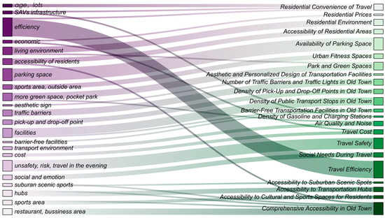
Figure 8.
Sankey diagram of key words and summary indices.
These indicators were systematically grouped into five criterion layers (B1–B5), which together constituted macro-theme A1: “the living environment, travel experience, and spatial quality demands of the residents in old town”. This hierarchical structure serves as a foundational framework for the analysis of the bidirectional adaptation strategies between SAVs and the complex spatial system of the old town. The dimensions and their corresponding indicators are as follows:
- A1. The living environment, travel experience, and spatial quality demands of the residents in the old town;
- B1. The influencing factors of residential area selection.
The following dimensions (C1–C4) reflect key factors shaping residents’ willingness to relocate or remain in specific residential areas:
- C1. Commuting convenience;
- C2. Residential cost affordability;
- C3. Quality of housing environment;
- C4. Spatial accessibility of residential area.
These elements help to assess the potential impacts of SAVs on residential attraction and the evolving spatial configuration of the old town.
- 3.
- B2. The daily functional space requirements of the old town.
Focusing on the accessibility and adaptability of essential urban functions (C5–C7), this dimension includes the following:
- C5. Availability of parking spaces;
- C6. Access to fitness and exercise facilities;
- C7. Green and recreational open spaces (e.g., parks, pocket parks).
This reflects residents’ expectations for the better integration of SAVs with multi-functional urban land use.
- 4.
- B3. Perceptions of the environmental quality of traffic spaces in the old town.
Comprising indicators C8–C14, this dimension captures how residents evaluate the sensory, functional, and ecological conditions of traffic spaces:
- C8. Street safety and orderliness;
- C9. Visual attractiveness and spatial aesthetics;
- C10. Reduction in noise pollution;
- C11. Improvements in air quality;
- C12. Human-centered and inclusive street design;
- C13. Compact and efficient infrastructure layout;
- C14. Harmony between mobility and livability.
This dimension helps to assess whether SAVs can enhance the quality of the urban transportation environment.
- 5.
- B4. Dimension of SAV service quality.
Indicators C15–C18 represent users’ core experience factors when using SAVs:
- C15. Affordability and cost-effectiveness of SAVs;
- C16. Safety and risk management in SAV operations;
- C17. Efficiency and reliability of SAV services;
- C18. Emotional and psychological comfort during rides.
These dimensions offer insights into residents’ acceptance and satisfaction with SAV-based urban mobility.
- 6.
- B5. The accessibility requirements of multi-functional urban spaces.
Reflecting broader spatial justice and service equity concerns, C19–C22 focus on access to key urban destinations:
- C19. Accessibility to transportation hubs;
- C20. Access to public service facilities;
- C21. Reachability of leisure and tourist destinations;
- C22. Accessibility within and beyond the old town area.
This dimension supports the evaluation of SAVs’ capacity to enhance urban connectivity and service coverage across spatial hierarchies.
This structured indicator system provides an empirical foundation for subsequent quantitative assessments, including AHP-EWM weighting, spatial accessibility analysis, and satisfaction gap evaluations. It also serves as a critical reference for policy recommendations on the optimized co-adaptation between emerging mobility technologies and the spatial characteristics of historical urban cores (Table 6, Figure 9).
Table 6.
Detail list for KJ method.
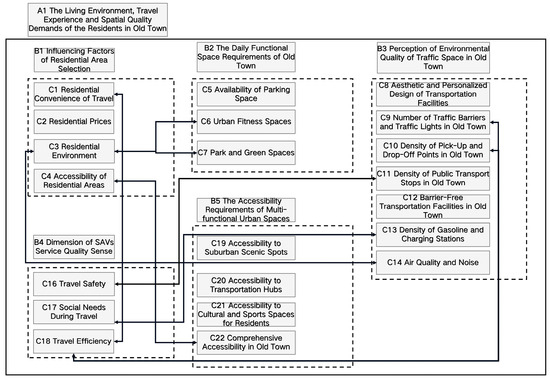
Figure 9.
The association relationships among various subject categories in the KJ method.
4. Discussion and Conclusions
4.1. User Demand Characteristic Analysis Based on KJ Method
The interview data revealed a paradoxical public attitude toward SAVs: while respondents generally maintained an optimistic outlook, they simultaneously expressed profound concerns regarding safety. This finding is consistent with previous studies suggesting that safety concerns may negatively influence the adoption of SAVs [49]. Residents’ apprehensions primarily focus on the perceived risk-handling capabilities of AI systems, the reliability of emergency response mechanisms (e.g., traffic gridlocks, system crashes), and ambiguities surrounding liability in the event of accidents. These concerns not only pertain to technological stability but also reflect deeper anxieties regarding machine ethics and the adaptability of AI in complex urban contexts [50].
Such findings are aligned with the existing literature on public trust in autonomous systems [51]. Notably, YouTube content creator Not Just Bikes articulated his personal fear of future automated mobility despite the prevailing optimism among researchers, emphasizing the psychological distance between expert assurance and public apprehension. This suggests that increasing transparency in algorithmic decision-making and enhancing safety protocols may mitigate public fears regarding the “black box” nature of AV technologies [52]. Addressing these issues is not merely a technical challenge but also a prerequisite for the widespread societal acceptance of SAVs.
At the level of residential preferences and the population distribution, divergent views emerged across different age groups. Several respondents expressed distinct generational lifestyle patterns, such as “I prefer living in the suburbs because it’s quieter” versus “I enjoy the lively atmosphere of the old town.” Older respondents (aged 40 and above) showed a stronger preference for suburban living, citing a desire to avoid the dense and dynamic environments of central districts. In contrast, younger residents (aged 18–30) emphasized accessibility and convenience, showing a strong preference for living in areas close to work, education, and leisure activities. This group also anticipated using SAVs to enable safe and efficient night travel.
However, Suzhou’s old town currently exhibits a significant aging population, with residents aged 60 and above accounting for 25.17% of the total population, compared to just 19.41% in the broader Suzhou metropolitan area [53,54]. This demographic imbalance implies that, with the implementation of SAVs and the consequent improvement in accessibility and commuting efficiency, younger populations may increasingly be drawn back to the old town, while older populations may shift toward quieter suburban settings. Such intergenerational shifts in residential preferences present new challenges for urban spatial restructuring. The development of SAVs may accelerate the rebalancing of the urban population and facilitate the emergence of a “jobs–housing balance” spatial paradigm [55].
In terms of parking land use, residents generally held a positive attitude toward the transformative potential of SAVs. Many anticipated that the technology would lead to more compact and efficient parking systems, with intelligent spatial arrangements maximizing land use in the constrained old town context. Residents believed that SAVs could help to alleviate the longstanding problem of parking scarcity in Suzhou’s historic core. Importantly, the repurposing of freed up parking areas was viewed as a key opportunity for spatial renewal—transforming underutilized parking lots into public spaces or mixed-use developments. This aligns with the global trend of “repurposing parking spaces” observed in many cities embracing transport innovation [56].
Nevertheless, some interviewees voiced concerns regarding the challenges posed by the initial implementation phase of SAVs, particularly with respect to governance. They emphasized the need for robust regulatory frameworks, infrastructure upgrades, and cross-sectoral coordination to ensure a smooth and equitable transition. The success of SAVs in reshaping the spatial structures of old urban areas thus relies not only on technological readiness but also on institutional adaptability and public trust.
From the perspective of regional accessibility, most interviewees believed that the application of SAV technology would significantly enhance the connectivity between suburban residential zones, tourist attractions, major transportation hubs, sports venues, and the core areas of the old town—especially in districts constrained by narrow streets and limited parking availability. SAVs were viewed as a potentially more competitive mobility option in such contexts. However, a subset of residents expressed reservations regarding the safety and maturity of SAVs, indicating that technological uncertainty may influence their daily mobility choices. This suggests that the widespread adoption of SAVs will require not only technical advancement but also robust policy guidance and the cultivation of public trust.
Regarding the optimization of street facilities and the urban environment, several respondents reiterated the critical role of public transportation in the old town’s mobility system. They cautioned against overemphasizing the advantages of emerging technologies while neglecting the risks associated with their implementation. During the transitional phase of transportation restructuring, the concept of multimodal redundancy—the coexistence of SAVs, public transit, and non-motorized systems (e.g., walking and cycling) within the same spatial framework—was seen as essential in maintaining accessibility equity among diverse user groups [57]. In this regard, inclusive design considerations, such as barrier-free infrastructure for vulnerable populations, must not be overlooked. The integration of SAVs into the old town’s transportation network must delicately balance efficiency, historical preservation, spatial quality, and residential livability to achieve synergistic urban optimization.
Drawing from the above, we further explore the potential impacts of SAVs on the old town’s spatial structure through three interrelated analytical dimensions: spatial evolution, social space and accessibility equity, and the cultural sensitivity of historical urban areas.
From a spatial structural standpoint, SAVs are driving the reconfiguration of the old town traffic space—particularly in relation to pick-up/drop-off areas, parking zones, and pedestrian mobility networks. These shifts trigger new forms of spatial overlap and conflict at the alleyway and neighborhood scale. This emerging restructuring calls for a redefinition of the boundaries between “shared” and “slow” mobility modes within micro-scale urban planning. Without such fine-grained control, the introduction of automated transport risks encroaching on human-centered spatial domains. These trends align with ongoing theoretical discourse on “urban regeneration”, “micro-renewal”, and “community upgrading” in the contemporary planning literature [58].
From the perspective of social spatial equity, SAVs offer potential improvements in traffic efficiency, reduced time costs, and expanded spatial access to cultural and ecological amenities. However, these benefits may also inadvertently reinforce pre-existing spatial hierarchies within the old town. For example, properties located near cultural landmarks or transit nodes may rapidly rise in value due to increased accessibility, exacerbating spatial inequalities. Young people who wish to reside in the old town may find themselves priced out, while older residents—despite preferring suburban environments—may remain for asset retention reasons. This could hinder efforts to achieve an intergenerational balance in the old town’s population structure and undermine social diversity.
Finally, the cultural landscape of the old town exhibits heightened sensitivity to technological intervention. Traditional alleyways, where daily life and intangible cultural heritage are tightly interwoven, often lack standardized traffic logic. This poses a challenge for SAVs’ AI navigation systems, which depend on predictable spatial rules and structured data inputs. Such mismatches echo broader concerns among architectural scholars that technological updates may dilute the emotional resonance and cultural continuity of historical districts. As cities become increasingly “smart”, safeguarding the embodied memory and lived experiences embedded in old urban forms must remain a core planning priority.
4.2. Practice Strategies
4.2.1. Proposed Strategy 1: Enhancing Public Trust Through Transparent Risk Assessment
The interview data reveal a paradoxical public perception toward SAVs: while the general attitude is optimistic, there is a widespread and profound concern regarding safety. Residents’ worries mainly focus on the risk perception capabilities of AI systems, response mechanisms during emergencies (e.g., traffic gridlock or system failures), and the assignment of liability in the event of an accident. These concerns are not limited to technical stability but also reflect broader anxieties about the adaptability of machine ethics in complex urban environments [50].
To mitigate such concerns, policymakers should implement transparent risk assessment mechanisms aimed at fostering public trust in SAVs.
- The integration of explainable artificial intelligence (XAI) frameworks is recommended to improve transparency in SAVs’ decision-making processes, thereby reducing public anxiety over so-called “black box” algorithms. In sensitive areas with historical heritage—such as Pingjiang Road—redundant control systems, including emergency manual override options, should be incorporated to minimize safety risks associated with technical malfunctions.
- Additionally, digital twin technologies can be employed to dynamically simulate the traffic flow in Suzhou’s Gusu District, optimizing SAVs’ operational strategies. By visually demonstrating the safety and efficiency of SAV deployment through real-time simulations, public acceptance and confidence in the technology can be significantly enhanced.
The proposed measures to enhance public trust through XAI and digital twin simulations are not only applicable to Suzhou but also hold significant potential for broader adoption across historic urban environments worldwide. Cities with intricate street networks and strong heritage preservation imperatives—such as Kyoto (Japan), Avignon (France), and Toledo (Spain)—could similarly benefit from transparency-oriented trust-building mechanisms that bridge emerging technologies with culturally sensitive urban settings.
However, effective implementation is contingent upon several preconditions, including robust digital infrastructure, adequate public digital literacy, and supportive regulatory frameworks that enable the integration of autonomous systems into the historically embedded urban fabric. In regions characterized by lower levels of digital maturity or heightened public skepticism toward AI—such as parts of Central and Eastern Europe—such mechanisms may need to be complemented by participatory public engagement processes and sustained capacity-building initiatives.
4.2.2. Proposed Strategy 2: Adopting a Polycentric Development Strategy to Enhance the Land Use Mix in the Old Town
Recent studies suggest that a single SAV can potentially replace three to nine privately owned cars [55], indicating that the widespread adoption of SAVs may help to alleviate the spatial and environmental pressures caused by the increasing number of private vehicles. However, the interview findings and demographic data indicate clear generational differences in residential preferences: residents over the age of 40 tend to prefer quieter suburban areas away from the urban core, whereas younger residents value accessibility to urban amenities and would rely on SAVs for efficient nighttime mobility. This generational divergence presents new challenges for the urban spatial structure and residential planning.
To address these differentiated needs while improving land use diversity within the old town, a polycentric development strategy (referring to the spatial decentralization of urban functions into multiple smaller hubs—as proposed to address land use intensity) is proposed.
In peripheral urban areas, the development of micro-community hubs is encouraged to integrate functions such as co-working spaces, telemedicine services, and community support facilities. These hubs can effectively reduce the reliance on central areas for daily commuting.
Meanwhile, within the historic core of the city, particularly in areas like Guanqian Street, land use adjustments should be made to enhance the vertical and horizontal integration of commercial, residential, and office functions. For example, the promotion of mixed-use developments—such as combining ground-floor retail with upper-floor residential units—can foster a more compact and efficient urban form. This would not only reduce long-distance commuting but also improve walkability and overall urban livability (Figure 10a–c and Figure 11).

Figure 10.
The current situation of Suzhou old town: (a) related urban functional planning zoning, (b) main transportation network of old town, (c) related urban POI, (d) planned historical and cultural blocks in old town (Special Planning for the Protection of Suzhou’s Historical and Cultural City).
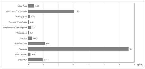
Figure 11.
The related urban spatial areas of Suzhou old town.
The polycentric development strategy proposed for Suzhou’s old town—featuring micro-community hubs and vertically integrated land use patterns—offers potential transferability to other historic cities grappling with spatial–functional imbalances. Cities such as Bologna (Italy), Bath (UK), and Graz (Austria), which share a common structure of compact heritage cores and rapidly expanding peripheries, may benefit from similar interventions aimed at balancing accessibility, livability, and cultural preservation.
However, the effectiveness of such a strategy remains highly contingent upon local land use regulations, property ownership frameworks, and urban morphological conditions. In European cities, where heritage protection laws are more stringent or building height restrictions are strictly enforced, vertical land use integration would require close coordination with preservation authorities, which may significantly constrain the implementation feasibility.
4.2.3. Proposed Strategy 3: Hierarchical Street Renovation Strategy to Reconcile Traffic Efficiency and Heritage Conservation
As SAVs are gradually integrated into the urban mobility systems of historic districts, it becomes imperative to strike a balance between traffic efficiency, heritage conservation, and the quality of urban spaces. Given the unique street morphology of old towns, a hierarchical renovation strategy is proposed to accommodate the functional diversity of different road types.
- Arterial Roads: For primary commuting corridors such as Ganjiang Road and Renmin Road (Figure 10b), the implementation of a time-variable lane allocation strategy is recommended. During peak hours, the existing traffic capacity should be maintained to ensure mobility, while, in off-peak periods, selected lanes can be dynamically repurposed as green buffers or pedestrian zones, thereby improving the streetscape quality. In addition, intelligent signal control systems should be deployed to optimize SAVs’ routing and ensure adaptability to fluctuating traffic conditions.
- Alleyways: In culturally sensitive alleyways (Figure 10d), motorized traffic should be strictly limited. Only low-speed SAVs (≤15 km/h) should be permitted, operating via subsurface optical guidance systems to enable minimally invasive navigation. This approach ensures the continuity of the pedestrian space while minimizing disruptions to the historical fabric and ambiance.
- Cultural Precincts: In core heritage zones, the establishment of zero-emission zones is advised. SAV transfer hubs should be located at the periphery to buffer the impact of motorized vehicles. Additionally, wayfinding systems should be enhanced using Suzhou-style aesthetic markers in place of standardized signage to ensure visual harmony with traditional cultural landscapes.
Moreover, throughout the process of mobility system restructuring, the principle of multimodal redundancy must be upheld. This means ensuring that SAVs, public transportation, and active modes (e.g., walking and cycling) are all effectively integrated within the core area. Such redundancy would support mobility equity for diverse user groups and provide the necessary flexibility during the technological transition phase.
The hierarchical street renovation framework—comprising time-regulated lanes, optical guidance systems in narrow alleyways, and zero-emission cultural precincts—offers a transferable conceptual model for historic urban areas with stratified street networks. Cities such as Bruges (Belgium) and Dubrovnik (Croatia), characterized by constrained medieval alleys and high densities of pedestrian tourism, face comparable challenges in modernizing their mobility systems without compromising their heritage value. However, successful adaptation requires context-sensitive calibration to local urban morphologies, material conservation codes, and tourism flows.
In European heritage towns with stone pavements, preservation-oriented construction codes, and strictly pedestrianized zones, the deployment of underground optical guidance or dynamic lane allocation may need to be translated into surface-level technologies or time-specific access strategies to ensure regulatory compliance and spatial integrity. These interventions must also be attuned to the current technological limitations of SAVs, particularly regarding the sensor resolution, latency in response, and spatial buffers required for emergency halts.
Furthermore, the proposed framework holds significant implications for the design and governance of urban transport infrastructure. By facilitating demand-responsive SAV routing and encouraging mixed-use land configurations, it can reduce the dependence on conventional parking structures and rigid public transit lines. The hierarchical restructuring of street space allows for more efficient road width distribution, enhances multimodal system resilience, and lays the groundwork for the seamless integration of low-emission and autonomous transport technologies in heritage-sensitive urban contexts.
4.3. Limitations and Future Research Directions
Although this study qualitatively explores the spatial implications of SAVs in the old town of Suzhou from a user-centered perspective, several limitations remain.
- Data Source Limitations: The study relies primarily on in-depth interview data. While it captures residents’ multidimensional perceptions, it may not fully reflect the objective impacts of SAVs on the urban space—such as changes in traffic flow, parking turnover rates, or land use efficiency—which require further support from quantitative data and geospatial analytics.
- Sampling Bias: The findings may be subject to bias due to differences in respondents’ backgrounds, ages, and travel habits. Especially in the current phase, where SAVs have not been widely deployed, residents’ attitudes are largely shaped by hypothetical assumptions and subjective impressions, rather than lived experience.
- Technological Uncertainty: The research does not fully account for the dynamic nature of SAV technologies. Future breakthroughs in AI, changes in transportation policy, or shifts in social demand could significantly reshape the urban spatial landscape. Thus, the current conclusions may require adaptation over time.
- Geographical Specificity: The study focuses exclusively on Suzhou’s old town, whose historical, spatial, and demographic characteristics are unique. The generalizability of the findings to other cities or different urban typologies remains to be tested through comparative or multi-case research.
- Implementation Challenges: Given that SAV technologies are still in the developmental stages, real-world deployment may encounter a variety of complex challenges—including infrastructure retrofitting, legal and regulatory adaptation, and varying levels of market acceptance—which exceed the scope of this study.
Additionally, the specificity of Suzhou’s old town—with its unique cultural regulations, population density, and tourism patterns—may limit the generalizability of the proposed strategies. The findings may not fully account for variability in local governance, infrastructure maturity, or public attitudes in other regions. Further, the rapid pace of SAVs’ technological development introduces an evolving challenge in aligning urban planning strategies with shifting system capabilities and regulatory conditions.
Despite the promise of XAI and digital twin technologies, real-world implementation in historic urban contexts remains fraught with challenges. These include high computational demands, unresolved data privacy concerns, and limitations in AI performance under real-time, unstructured environmental conditions. Sensor constraints—such as occlusions in narrow alleyways or diminished visibility during heavy rainfall—remain particularly acute in dense heritage areas where spatial irregularities are common. Moreover, the introduction of SAVs in culturally sensitive zones may encounter public resistance, especially where such interventions are perceived as intrusive or disruptive to the historical character of the area. High tourist densities and unpredictable pedestrian behavior along heritage corridors further complicate the deployment of sensor-based navigation systems, raising questions about reliability, safety, and the spatial–temporal alignment of autonomous mobility with existing urban rhythms.
Looking ahead, the promotion of SAVs must be driven by an integrated approach encompassing technological innovation, policy alignment, and urban spatial planning. Future research should leverage large-scale empirical data, simulation-based models, and comparative case studies to enhance the robustness and transferability of the findings. Only through such a multidimensional framework can the deployment of SAVs effectively optimize urban spatial structures, enhance residents’ travel experiences, and guide the sustainable transformation of historic urban districts. While this study primarily focuses on qualitative spatial reconfiguration, subsequent work could incorporate agent-based simulation platforms—such as MATSim or SUMO—to model SAV operations under varied historic street conditions. This would enable the data-informed optimization of routing strategies, vehicle density thresholds, and infrastructure adaptation, offering deeper insights into the spatial–temporal dynamics of autonomous mobility in heritage-rich environments.
This study did not include perspectives from local planning officials or business owners. Future research should adopt a multi-stakeholder approach to capture the planning rationale and economic dimensions associated with SAV deployment in heritage zones.
Given the low actual exposure to SAVs among the participants, many responses were shaped by media narratives or speculative assumptions. This limits the ecological validity of some perceptions, especially regarding safety and comfort. Future studies may benefit from simulation-based tools or immersive mock-ups to elicit more experience-aligned responses.
5. Conclusions
The integration of SAVs into historic urban centers represents not merely a technological shift but a catalyst for the reconfiguration of spatial structures, retrofitting strategies, and mechanisms of public trust. Drawing on a qualitative inquiry conducted in Suzhou’s old town, this study proposes three strategic pathways: (1) transparent risk assessment frameworks—leveraging XAI and digital twin simulations—to build public confidence; (2) polycentric development models to accommodate diverse land use demands and decentralize urban functions; and (3) hierarchical street retrofitting to reconcile mobility enhancement with heritage preservation. Collectively, these strategies underscore the imperative to move beyond technocentric narratives and embrace the spatial, social, and cultural dimensions of mobility transitions in heritage-sensitive contexts.
Nevertheless, this study is not without limitations. The qualitative sample of 27 participants, while sufficient for thematic saturation, may not fully capture the heterogeneity of stakeholder perspectives—particularly those of vulnerable or mobility-impaired populations. In addition, the proposed strategies remain conceptual and require empirical testing through real-world pilot implementations and cross-contextual comparisons with other historic cities in China and beyond.
Future research should incorporate multi-source datasets—including real-time traffic sensors, pedestrian behavioral tracking, and GIS-based simulation models—to triangulate insights and enhance the analytical robustness. A longitudinal perspective is also essential to evaluate the enduring socio-spatial impacts of SAV deployment over time. By acknowledging its methodological constraints while articulating actionable research directions, this study offers both strategic foresight and a foundation to guide sustainable, culturally attuned mobility transformations in legacy urban environments.
Author Contributions
Conceptualization, S.Y. and K.B.; methodology, S.Y. and S.T.; software, S.Y. and X.C.; validation, S.Y., X.C. and Z.Z.; formal analysis, S.Y.; investigation, S.Y. and K.B.; data curation, S.Y. and Z.Z.; writing—original draft preparation, S.Y.; writing—review and editing, K.B.; visualization, S.Y.; supervision, K.B.; project administration, K.B. All authors have read and agreed to the published version of the manuscript.
Funding
This research received no external funding.
Institutional Review Board Statement
The study was conducted in accordance with the Declaration of Helsinki, and approved by the Institutional Review Board of King Mongkut’s University Technology Thonburi (protocol code KMUTT-IRB-COE-2025-044 and 19 December 2024 of approval).
Informed Consent Statement
Informed consent was obtained from all subjects involved in the study.
Data Availability Statement
The data presented in this study are available on request from the corresponding author.
Acknowledgments
The authors thank all respondents for their help with this research. They also thank the reviewers, whose comments were helpful and practical.
Conflicts of Interest
The authors declare no conflicts of interest.
Abbreviations
The following abbreviations are used in this manuscript:
| AI | Artificial Intelligence |
| SAVs | Shared Autonomous Vehicles |
| IEEE | Institute of Electrical and Electronic Engineers |
| SAE | Society of Automotive Engineers |
| AVs | Autonomous Vehicles |
| V2X | Vehicle-to-Everything |
| VTT | Value of Travel Time |
| PAVs | Private Autonomous Vehicles |
| VKT | Vehicle Kilometers Traveled |
| XAI | Explainable Artificial Intelligence |
References
- Ji, L.; Zhang, W.; Sun, S. Urban spatial optimization and high-quality economic development: Empirical evidence based on district boundary reorganization. J. Finance Econ. 2023, 49, 4–18. [Google Scholar] [CrossRef]
- UN DESA. World Urbanization Prospects the 2018 Revision; United Nations Department of Economic and Social Affairs: New York, NY, USA, 2018. [Google Scholar]
- Wang, W.; Li, M.; Li, J.; Zhang, Y. Exploration on renewal and protection methods of historical and cultural cities: A case study of Suzhou CIM. Urban Dev. Stud. 2023, 30, 96–102. [Google Scholar]
- GB/T51328-2018; Standard for Urban Comprehensive Transport System Planning. CAUPD China Architecture & Building Press: Beijing, China, 2019.
- Suzhou Daily Suzhou Motor Vehicle Ownership Exceeded 5 Million. Available online: https://www.suzhou.gov.cn/szsrmzf/szyw/202210/3fc13e7b5b554fb289fddd9f7a34aa21.shtml (accessed on 21 March 2025).
- UITP. What Is the “New Normal” for Travel? UITP: Brussels, Belgium, 2023; pp. 1–12. [Google Scholar]
- Ipsos. Towards Zero Emissions Mobility: A Study on Urban Public Awareness, Behavior, and Drivers. 2022. Available online: https://www.efchina.org/Attachments/Report/report-comms-20220710/Towards-Zero-Emissions-Mobility-A-Study-on-Urban-Public-Awareness-Behavior-and-Drivers.pdf (accessed on 14 June 2025).
- Liu, P.; Zhang, N. Construction Path Exploration of Slow Driving System Based on Urban Material Space Characteristics. Available online: http://mp.weixin.qq.com/s?__biz=MzA3NTE1MjI5MA==&mid=2650850897&idx=2&sn=7e2ddfeb1ad89803751a75a7f2b4236c&chksm=854ef567013ac7fcb1f66b08e656e7551d85d743c34a9c8269e6e97532613c7a0335a12e1e46#rd (accessed on 21 March 2025).
- Stevens, P. Electric and Hybrid Vehicles Will Account for Nearly Half the Cars on the Road by 2040, Goldman Predicts. Available online: https://www.cnbc.com/2022/04/04/electric-and-hybrid-vehicles-will-account-for-nearly-half-the-cars-on-the-road-by-2040-goldman-predicts.html (accessed on 21 March 2025).
- Wang, W.; Zhu, J.; Zheng, S. The Characters of Urban Space in Automated Vehicle Era. Planners 2018, 34, 155–160. [Google Scholar]
- Shuttleworth, J. SAE Standards News: J3016 Automated-Driving Graphic Update. Available online: https://www.sae.org/site/news/2019/01/sae-updates-j3016-automated-driving-graphic (accessed on 24 March 2025).
- Zhang, W.; Chen, Y.; Jiang, Y. An Overview of the Impacts of Autonomous Vehicles on Urban Spatial Form. Urban Transp. China 2022, 20, 1–10. [Google Scholar] [CrossRef]
- Hawkins, J.; Nurul Habib, K. Integrated Models of Land Use and Transportation for the Autonomous Vehicle Revolution. Transp. Rev. 2019, 39, 66–83. [Google Scholar] [CrossRef]
- Narayanan, S.; Chaniotakis, E.; Antoniou, C. Shared Autonomous Vehicle Services: A Comprehensive Review. Transp. Res. Part C Emerg. Technol. 2020, 111, 255–293. [Google Scholar] [CrossRef]
- Nimish Biloria Autonomous Mobility in the Built Environment. In Intelligent Environments; North-Holland: Amsterdam, The Netherlands, 2023; pp. 351–394.
- Wikipedia. Old Town; Wikipedia: San Francisco, CA, USA, 2020. [Google Scholar]
- Wang, F.; Lv, Z.; Zhang, B.; Zhang, S.; Dong, W.; Liu, P.; Huang, Z.; Wu, B.; Lu, S.; Xu, F.; et al. Memory and homesickness in transition: Evolution mechanism and spatial logic of urban and rural memory. Geogr. Res. 2017, 36, 3–25. [Google Scholar]
- Yao, Y. Research on the Dilemma and Countermeasures of Urban Renewal in the Ancient City of Suzhou. Master’s Disseration, Soochow University, Suzhou, China, 2023. [Google Scholar]
- Li, S.; Sun, L. 2021 Urban Transport Travel Report: More Than 70% of Urban Residents’ Preferred Shared Travel Online Car Self-Driving or Bring Subversive Changes. Available online: https://www.nbd.com.cn/articles/2021-04-14/1696819.html (accessed on 26 March 2025).
- Stead, D.; Vaddadi, B. Automated Vehicles and How They May Affect Urban Form: A Review of Recent Scenario Studies. Cities 2019, 92, 125–133. [Google Scholar] [CrossRef]
- Ambühl, L.; Ciari, F.; Menendez, M. What About Space? A Simulation Based Assessment of AVs Impact on Road Space in Urban Areas. In Proceedings of the 16th Swiss Transport Research Conference, Ascona, Switzerland, 18–20 May 2016; pp. 1–9. [Google Scholar]
- Thakur, P.; Kinghorn, R.; Grace, R. Urban Form and Function in the Autonomous Era. In Proceedings of the 38th Australasian Transport Research Forum (ATRF 2016), Melbourne, Australia, 16–18 November 2016; ARRB: Victoria, Australia, 2016; pp. 1–15. [Google Scholar]
- Zhang, W.; Guhathakurta, S. Residential Location Choice in the Era of Shared Autonomous Vehicles. J. Plan. Educ. Res. 2018, 41, 135–148. [Google Scholar] [CrossRef]
- Stocker, A.; Shaheen, S. Shared Automated Vehicles: Review of Business Models; OECD: Paris, France, 2017; pp. 5–21. [Google Scholar]
- Yang, L.; Liang, Y.; Zhang, S.; Bai, J. Smart Street Design in the Era of Autonomous Driving: An Overview of Historical Evolution and Development Trends. Urban Plan. Int. 2024, 1–18. [Google Scholar] [CrossRef]
- Qin, B.; Chen, X.; Qu, S. The Impacts of Autonomous Vehicle on the Cities and Planning Responses: A Literature Review Based on Ripple Effect Model. Urban Plan. Int. 2019, 34, 108–114. [Google Scholar] [CrossRef]
- Milakis, D.; Van Arem, B.; Van Wee, B. Policy and Society Related Implications of Automated Driving: A Review of Literature and Directions for Future Research. J. Intell. Transp. Syst. 2017, 21, 324–348. [Google Scholar] [CrossRef]
- Katerinin, K.; Sanzhapov, B. Optimization of the Traffic Light Regulation Parameters on the Urban Road Network in Order to Minimize the Negative Environmental Impact. E3S Web Conf. 2019, 138, 1024. [Google Scholar] [CrossRef]
- He, Y.; Lin, H.; Liu, Y.; Yang, L.; Qu, X. Applications and Challenges of Reinforcement Learning. J. Tongji Univ. Sci. 2024, 52, 520–531. [Google Scholar] [CrossRef]
- Ou, J.; Wang, M. A study on the comprehensive evaluation and decision optimization of Suzhou old town capacity. City Plan. Rev. 2023, 47, 43–53. [Google Scholar]
- Yang, J.; Yang, Z. Adjustment and Optimization of the Carrying Capacity of the Ancient City of Suzhou for Social Sustainability. Urban Plan. Forum 2024, 283, 65–73. [Google Scholar] [CrossRef]
- Ruan, Y.; Liu, H. Gusu Xin Xu, 1st ed.; China Architecture & Building Press: Beijing, China, 2005. [Google Scholar]
- Suzhou Daily The 7th National Census Data of Suzhou City Was Released, and the Total Population, Population Increment and Growth Rate Were the First in the Province, The Number of Talents Accounted for the Second in the Province, and the Proportion of the Elderly Aged 65 and Above Was the Lowest in the Province. Available online: https://www.suzhou.gov.cn/szsrmzf/szyw/202105/d2f835220e41475da3cab680df16d7a2.shtml (accessed on 28 March 2025).
- Fan, L. Evolution and Reflection on Rural Planning of City-cluster Areas from the Perspective of Urban-rural Relationship: A Case Study of Suzhou. Urban Plan. Forum 2015, 6, 106–113. [Google Scholar] [CrossRef]
- Wandenkolk, I.; Winter, S.; Stetten, N.; Classen, S. Department of Veterans Affairs’ Transportation System: Stakeholder Perspectives on the Current and Future System, Including Electric Autonomous Ride-Sharing Services. World Electr. Veh. J. 2025, 16, 293. [Google Scholar] [CrossRef]
- Fu, X.; Nie, Q.; Liu, J.; Zhang, Z.; Jones, S. How Do College Students Perceive Future Shared Mobility with Autonomous Vehicles? A Survey of the University of Alabama Students. Int. J. Transp. Sci. Technol. 2022, 11, 189–204. [Google Scholar] [CrossRef]
- Etminani-Ghasrodashti, R.; Ketankumar Patel, R.; Kermanshachi, S.; Michael Rosenberger, J.; Weinreich, D.; Foss, A. Integration of Shared Autonomous Vehicles (SAVs) into Existing Transportation Services: A Focus Group Study. Transp. Res. Interdiscip. Perspect. 2021, 12, 100481. [Google Scholar] [CrossRef]
- Zhang, W.; Guhathakurta, S.; Fang, J.; Zhang, G. Exploring the Impact of Shared Autonomous Vehicles on Urban Parking Demand: An Agent-Based Simulation Approach. Sustain. Cities Soc. 2015, 19, 34–45. [Google Scholar] [CrossRef]
- Xia, B.; Wu, J.; Wang, J.; Fang, Y.; Shen, H.; Shen, J. Sustainable Renewal Methods of Urban Public Parking Spaces under the Scenario of Shared Autonomous Vehicles (SAV): A Review and a Proposal. Sustainability 2021, 13, 3629. [Google Scholar] [CrossRef]
- Gu, T.; Yang, X.; Jiang, W.; Yao, C.; Chen, S.; Tian, R. Supply-oriented demand control of private car use in central urban areas: An empirical study on typical cases. 2023, 1–15. [Google Scholar] [CrossRef]
- Heinrichs, D. Autonomous Driving and Urban Land Use. In Autonomous Driving; Maurer, M., Gerdes, J.C., Lenz, B., Winner, H., Eds.; Springer: Berlin/Heidelberg, Germany, 2016; pp. 213–231. ISBN 978-3-662-48845-4. [Google Scholar]
- Zhu, W.; Huang, W.; Yue, D.; Cheng, Y. Evaluation of Elderly-oriented Public Space Facilities in Old Neighborhoods. Packag. Eng. 2023, 44, 169–177, 200. [Google Scholar] [CrossRef]
- Viriyayudhakorn, K. Creativity Assistants and Social Influences in KJ-Method Creativity Support Groupware. Ph.D. Dissertation, Japan Advanced Institute of Science and Technology, Nomi, Japan, 2013. [Google Scholar]
- Huang, Z.; Yang, Z.; Liang, Y. Research on the Design of Public Facilities in Nandan Baiku Yao Scenic Area Based on Miryoku Engineering Theory. Packag. Eng. 2023, 44, 431–439. [Google Scholar] [CrossRef]
- Mason, M. Sample Size and Saturation in PhD Studies Using Qualitative Interviews. Forum Qual. Sozialforschung Forum Qual. Soc. Res. 2010, 11, 1–19. [Google Scholar] [CrossRef]
- SP Consulting The Market Size and Growth Trend of China’s Online Car Hailing in 2022. Available online: https://www.sohu.com/a/www.sohu.com/a/666196015_120245260 (accessed on 26 March 2025).
- National Bureau of Statistics How to Distinguish Between Permanent Residents and Floating Population? Available online: https://www.stats.gov.cn/zs/tjws/tjbz/202301/t20230101_1903796.html (accessed on 19 April 2025).
- Danilevičius, A.; Danilevičienė, I.; Karpenko, M.; Stosiak, M.; Skačkauskas, P. Determination of the Instantaneous Noise Level Using a Discrete Road Traffic Flow Method. Promet-Traffictransportation 2025, 37, 71–85. [Google Scholar] [CrossRef]
- Nazari, G.; Bobos, P.; MacDermid, J.C.; Birmingham, T. The Effectiveness of Instrument-Assisted Soft Tissue Mobilization in Athletes, Participants without Extremity or Spinal Conditions, and Individuals with Upper Extremity, Lower Extremity, and Spinal Conditions: A Systematic Review. Arch. Phys. Med. Rehabil. 2019, 100, 1726–1751. [Google Scholar] [CrossRef]
- Nyholm, S.; Smids, J. Automated Cars Meet Human Drivers: Responsible Human-Robot Coordination and the Ethics of Mixed Traffic. Ethics Inf. Technol. 2020, 22, 335–344. [Google Scholar] [CrossRef]
- Zmud, J.; Sener, I.N.; Wagner, J. Self-Driving Vehicles: Determinants of Adoption and Conditions of Usage. Transp. Res. Rec. J. Transp. Res. Board 2016, 2565, 57–64. [Google Scholar] [CrossRef]
- Zhong, X. From Algorithmic “ Black Box” to Algorithmic Transparency: A Dualistic Law Governance Model Based on “ Hard Law-Soft Law”. Chin. J. Marit. Law 2023, 34, 53–62. [Google Scholar]
- Bureau of Statistics of Gusu District Bulletin of the Seventh National Population Census of Gusu District. Available online: https://tjgb.hongheiku.com/12035.html (accessed on 29 April 2025).
- The Paper The Permanent Resident Population of Suzhou Increased by 47,400 Last Year, and the Total Number Continued to Rank First in Jiangsu Province. Available online: https://baijiahao.baidu.com/s?id=1793569016472174704&wfr=spider&for=pc (accessed on 29 April 2025).
- Fagnant, D.J.; Kockelman, K. Preparing a Nation for Autonomous Vehicles: Opportunities, Barriers and Policy Recommendations. Transp. Res. Part Policy Pract. 2015, 77, 167–181. [Google Scholar] [CrossRef]
- Millard-Ball, A. The Autonomous Vehicle Parking Problem. Transp. Policy 2019, 75, 99–108. [Google Scholar] [CrossRef]
- Karpenko, M.; Prentkovskis, O.; Skačkauskas, P. Analysing the Impact of Electric Kick-Scooters on Drivers: Vibration and Frequency Transmission during the Ride on Different Types of Urban Pavements. Eksploat. Niezawodn.—Maint. Reliab. 2025, 27, 2025. [Google Scholar] [CrossRef]
- Ma, H. Research on the Development and Evolution of Urban Renewal in China Based on Periodical Literature Statistics. Master’s Thesis, Xian University of Architecture and Technology, Xi’an, China, 2022. [Google Scholar]
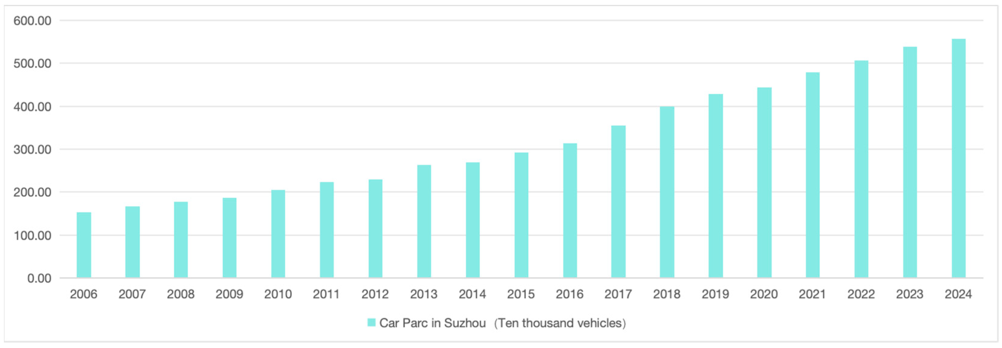
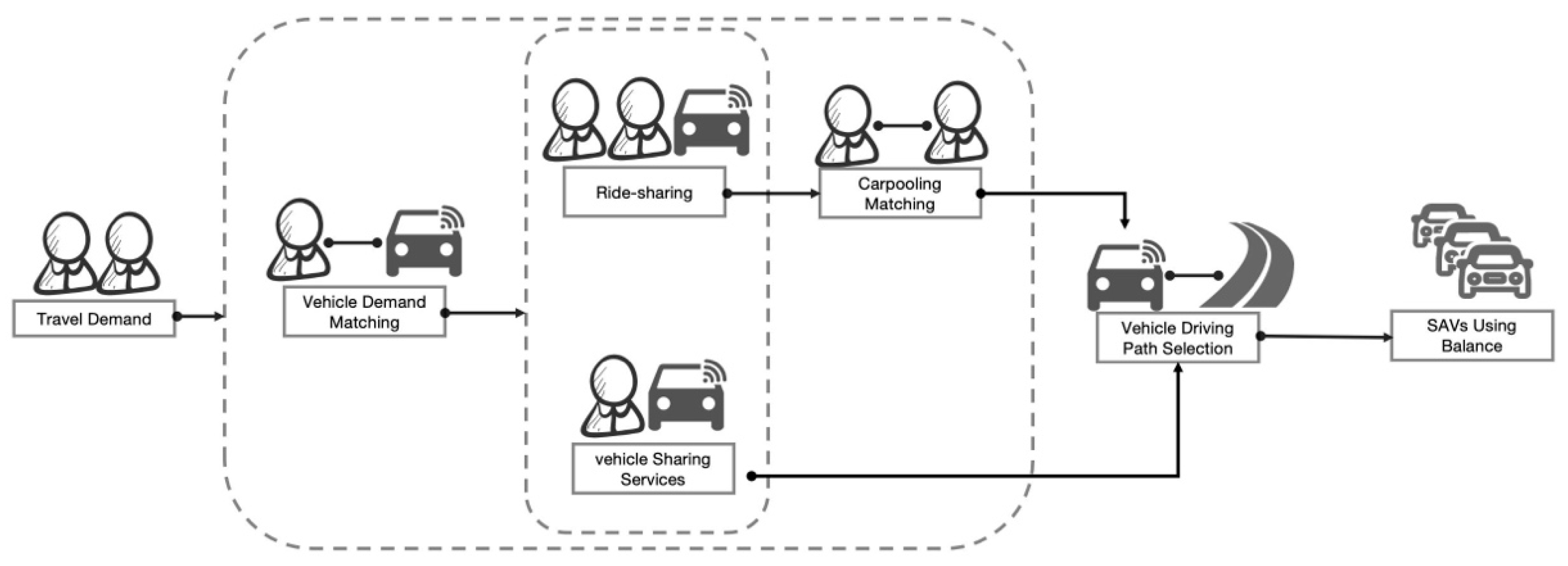
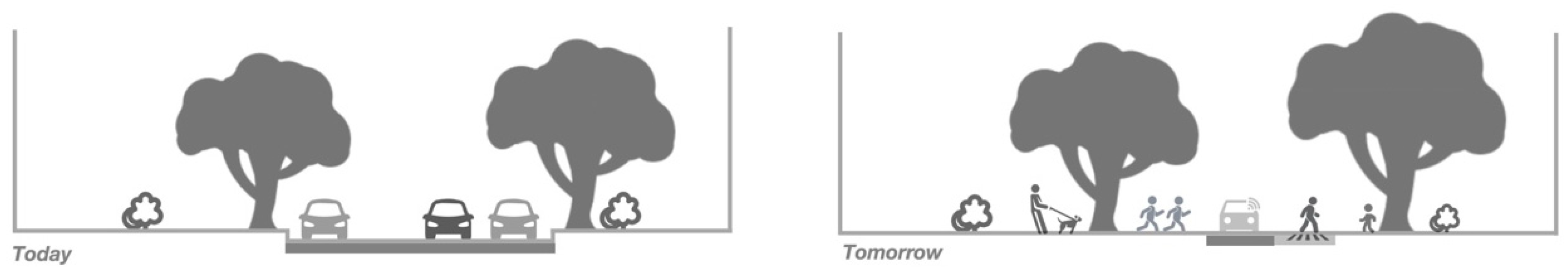
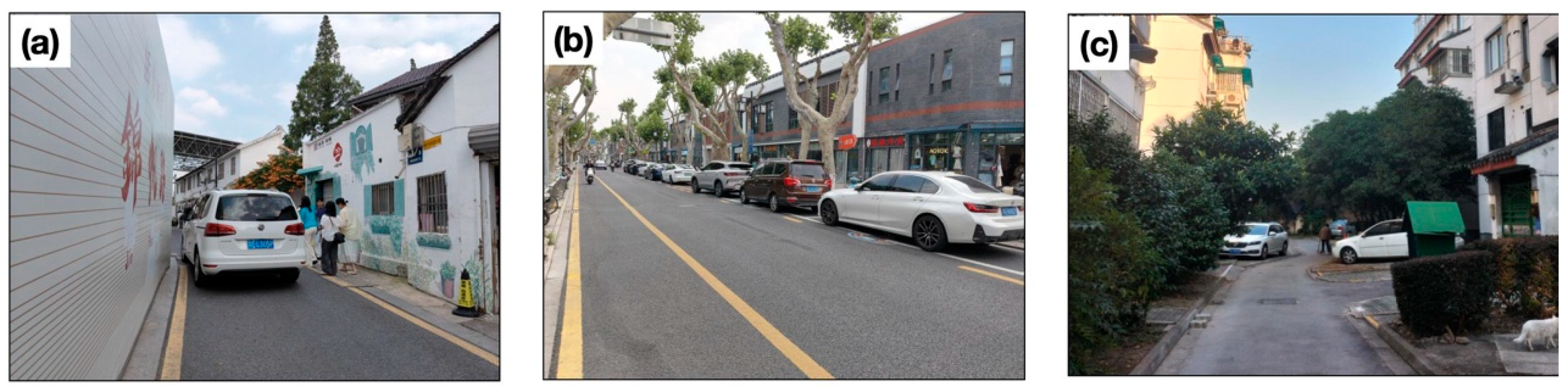
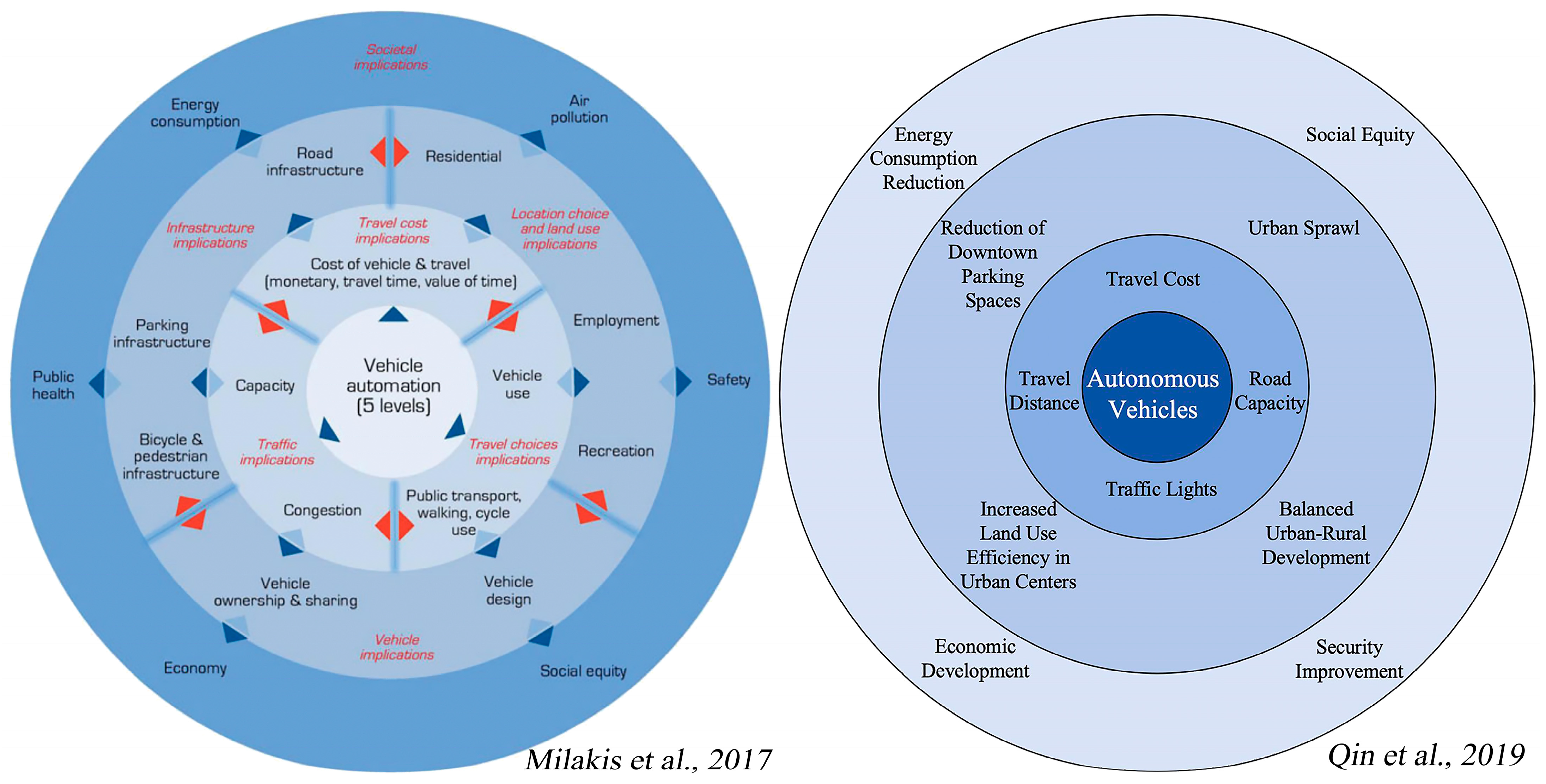
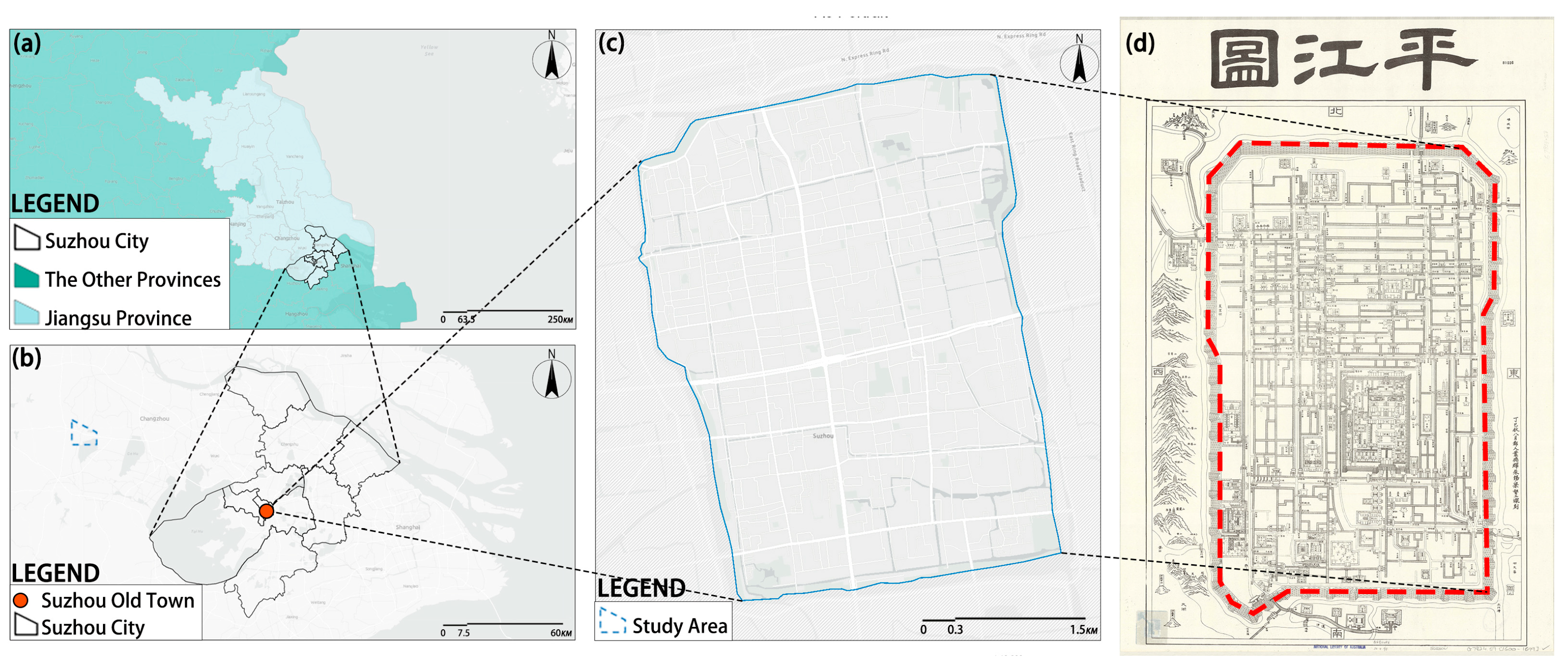
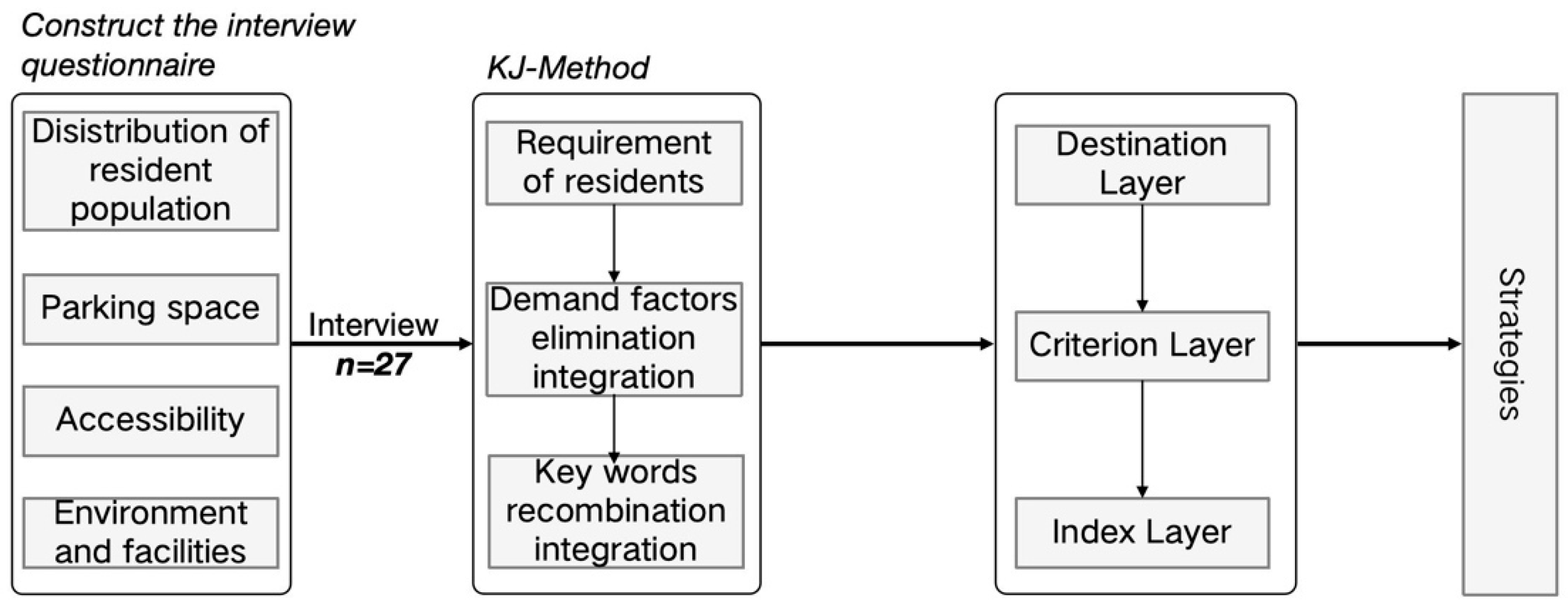
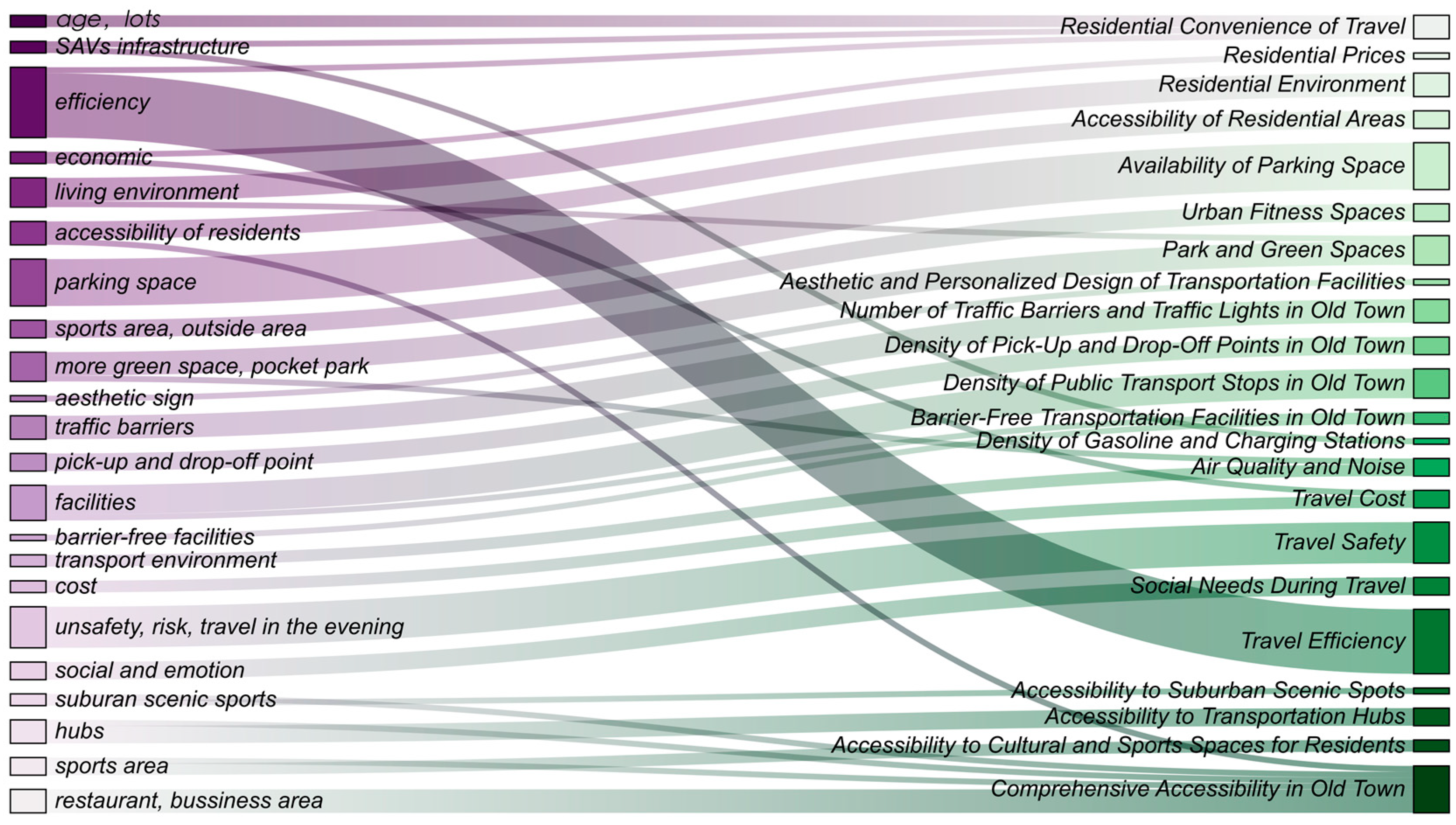
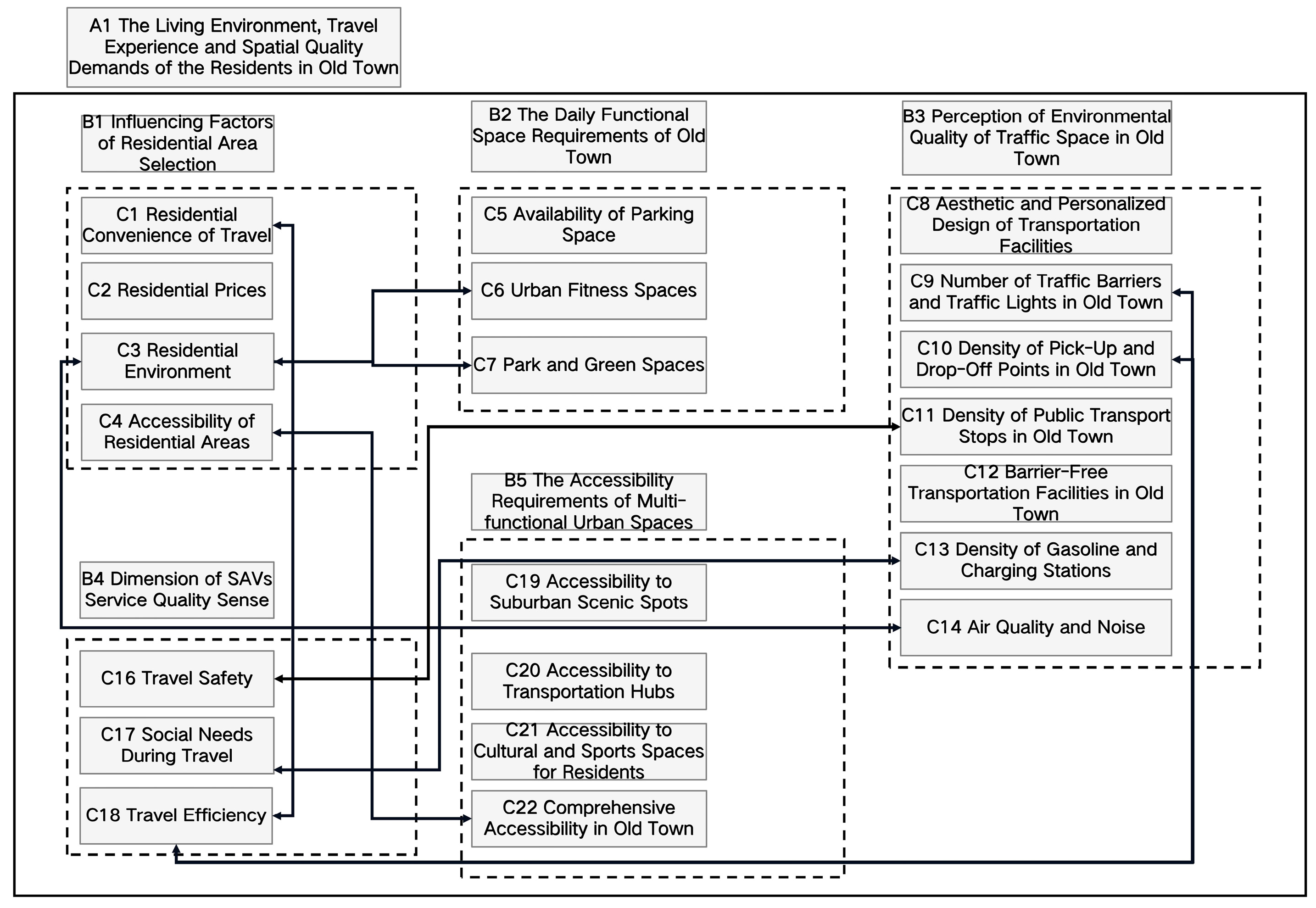
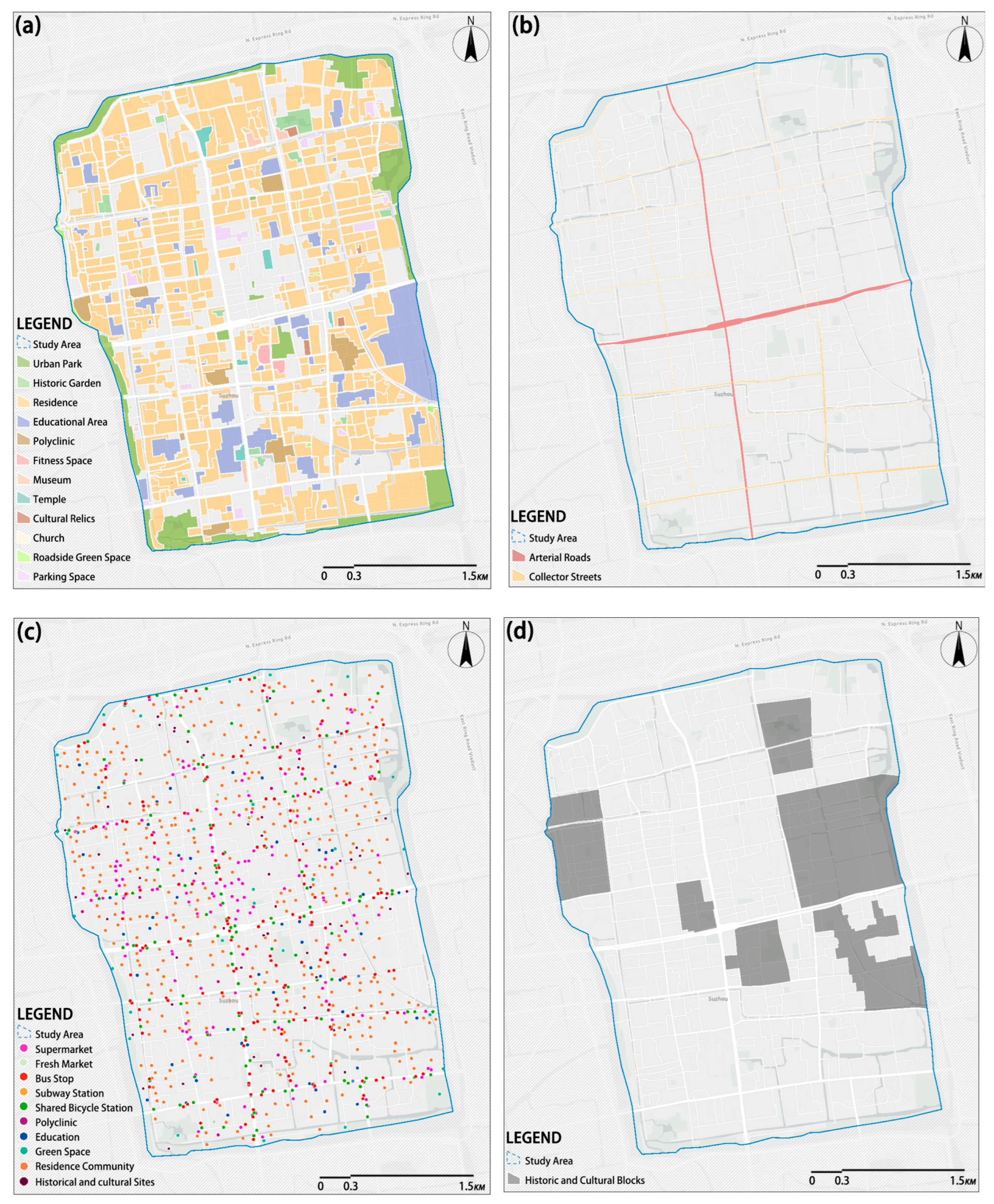

Disclaimer/Publisher’s Note: The statements, opinions and data contained in all publications are solely those of the individual author(s) and contributor(s) and not of MDPI and/or the editor(s). MDPI and/or the editor(s) disclaim responsibility for any injury to people or property resulting from any ideas, methods, instructions or products referred to in the content. |
© 2025 by the authors. Published by MDPI on behalf of the World Electric Vehicle Association. Licensee MDPI, Basel, Switzerland. This article is an open access article distributed under the terms and conditions of the Creative Commons Attribution (CC BY) license (https://creativecommons.org/licenses/by/4.0/).